Adventure Magazine
Issue 230, February/March 2022
Issue 230, February/March 2022

Create successful ePaper yourself
Turn your PDF publications into a flip-book with our unique Google optimized e-Paper software.
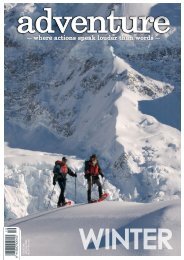
Scott’s track up to Avalanche Peak is a steep and rocky but<br />
easily accessible path from Arthurs Pass village. Rising the<br />
1.1km over 2.5km, this is no walk in the park especially with an<br />
overnight pack on your back. But it also offers plenty to enjoy as<br />
you try to keep your heart rate in check.<br />
Within the first half-hour you get to take in priceless views<br />
eastwards to the Temple Basin ski field and the ice-splattered<br />
summits of Stuart, Phipps and Blimit, all over 1900m. Behind<br />
us Arthurs Pass village became more and more like a miniature<br />
kitset as we climbed. Kea were calling across to each other<br />
as they searched for breakfast amongst the trees and shrubs.<br />
The sound of water cascading down the 130 metre Devils<br />
Punchbowl waterfall across the valley ebbed and flowed for the<br />
first hour or so, muted by the trees, the distance and the breeze.<br />
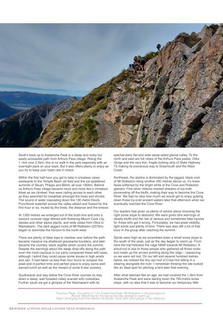
At 1300 metres we emerged out of the bush-line and onto a<br />
tussock covered ridge littered with flowering Mount Cook Lily,<br />
daisies and other alpine plants, and wide vistas from Otira to<br />
Waimakariri. The dark jagged rocks of Mt Rolleston (2275m)<br />
began to dominate the horizon to the north-west.<br />
There are plenty of false tops to clamber over before the path<br />
became massive ice-shattered greywacke boulders, and later<br />
became the crumbly, black argillite which covers the summit.<br />
Despite the warnings about the steep drop-offs along the path<br />
even the most cautious in our party conquered these with ease,<br />
although I admit they could cause some issues in high winds<br />
and rain. It had taken us less than four hours to conquer the<br />
peak and in perfect time and perfect place to enjoy some wellearned<br />
lunch as well as the reward of some 6-star scenery.<br />
Southwards and way below the Crow River courses its way<br />
down a steep, well forested valley scarred with rockslides.<br />
Further south we got a glimpse of the Waimakariri with its<br />
spectacularly flat and wide steep-sided glacial valley. To the<br />
north and east are full views of the Arthurs Pass peaks, Otira<br />
Gorge and the very thin, fragile looking strip of State Highway<br />
73 making its precarious way to Greymouth and the West<br />
Coast.<br />
Northwest, the skyline is dominated by the jagged, black rock<br />
of Mt Rolleston rising another 450 metres above us, it’s lower<br />
faces softened by the bright white of the Crow and Rolleston<br />
glaciers. Fine silver ribbons marked streams of ice-melt<br />
plummeting off the bluffs, making their way to become the Crow<br />
River. We had no idea how much we would get to enjoy gulping<br />
down those icy-cold ancient waters later that afternoon when we<br />
eventually reached the Crow River.<br />
Our leaders had given us plenty of advice about choosing the<br />
right scree slope to descend. We were given dire warnings of<br />
deadly bluffs and the risk of serious and sometimes fatal injuries<br />
for those who get it wrong. Fortunately, we had great visibility,<br />
light winds and plenty of time. There was also still a bit of that<br />
buzz in the group after reaching the summit.<br />
Spirits were high as we scrambled down a small scree slope to<br />
the south of the peak, just as the day began to warm up. From<br />
here the trail followed the ridge NNW towards Mt Rolleston. A<br />
shout-out is due to those people who gathered all those rocks<br />
and made up the arrows pointing along the ridge – reassuring<br />
us we were not lost. On our left and several hundred metres<br />
below, we noticed the tiny red roof of Crow Hut sitting in a<br />
clearing alongside the river. I remember thinking the site looked<br />
like an ideal spot for pitching a tent later that evening.<br />
After what seemed like an age, we had covered the 1.5km from<br />
Avalanche Peak and were staring down the 700-metre scree<br />
slope, with no idea that it was to become our temporary little<br />
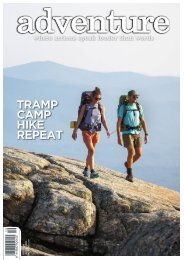
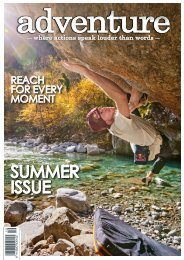
Previous Page: Our party of 7 on Avalanche Peak, Mt Rolleston in the backgound.<br />
Above: Reaching for the top as the day started to warm up.<br />
Right: Emerging from the treeline on Scotts Track with Otira gorge in the distance.<br />
24//WHERE ACTIONS SPEAK LOUDER THAN WORDS/#230