ADV229 online
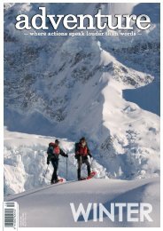
Summer issue of Adventure Magazine
Summer issue of Adventure Magazine

Create successful ePaper yourself
Turn your PDF publications into a flip-book with our unique Google optimized e-Paper software.
Hike two: Rangipo Hut<br />
Two days, one night<br />
5 km one way to Rangipo, approximately 4 hours return<br />
Access to this section of the Round the Mountain Track is from<br />
Desert Road, via the Waihohonu Track (a full day hike) or from the<br />
4WD access road to Tukino Ski Field. We took the latter, and have a<br />
new found respect for the local skiers, who drive this road to access<br />
the ski field.<br />
This side of the mountain is in stark contrast to our first hike, the<br />
track for most of the way is sparce of vegetation and very exposed<br />
to the elements. According to DOC it is the only true desert<br />
landscape in the North Island, with features of vast plains of windswept<br />
sands and volcanic rock.<br />
The first significant landmark, and challenging section of this part of<br />
the track is crossing the Whangaehu River lahar path, an area with<br />
great historical significance in New Zealand, being responsible for<br />
the 1953 Tangiwai Disaster. There are plenty of signs warning you<br />
that you are in the area and they are somewhat ominous. “Do not<br />
stop”… “Do not enter if you hear a loud roaring noise upstream.”<br />
It does make for a rather nervous crossing, not only does it come<br />
with some potential lahar danger, the terrain itself is also quite<br />
challenging, with large rocks and valleys to clamber over and<br />
under as well as a single person bridge in the middle. However, the<br />
scenery here is spectacular, particularly the view of the mountain on<br />
a clear day.<br />
Although only 5km to the hut, the terrain is varied with lots of ups<br />
and downs. The trail is largely unformed but well-marked, mostly<br />
rocky with large tracks of fine scoria, making our poles invaluable.<br />
Rangipo Hut is a serviced 20 bunk hut facing east and sitting at an<br />
altitude of 1556m. It’s perched on the southern edge of the desert<br />
looking out to the Kaimanawa Mountains and Desert Road. The<br />
positioning of this hut offers impressive sunrises on a clear morning,<br />
worth getting up early for, and a vast night sky. Reading the hut<br />
book, with tales of stormy nights and blizzard conditions, it reminded<br />
us that clear weather is not always a guarantee.<br />
"Extreme lahar risk, next 400m.<br />
Do not stop in this area.<br />
Do not proceed past here if you<br />
hear a loud roaring noise upriver"<br />
If you are lucky enough to get great weather, you can climb the<br />
rocky outcrop directly behind the hut, and the mountain will reveal<br />
itself.<br />
30//WHERE ACTIONS SPEAK LOUDER THAN WORDS/#229