

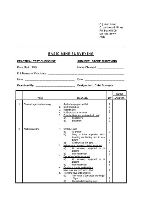
BASIC MINE SURVEYING
BASIC MINE SURVEYING
BASIC MINE SURVEYING

You also want an ePaper? Increase the reach of your titles
YUMPU automatically turns print PDFs into web optimized ePapers that Google loves.
<strong>BASIC</strong> <strong>MINE</strong> <strong>SURVEYING</strong><br />
PRACTICAL TEST CHECKLIST SUBJECT: STOPE <strong>SURVEYING</strong><br />
Pass Mark: 75% Marks Obtained: __________________<br />
Full Names of Candidate: ____________________________________________________<br />
Mine: __________________________________ Date: ___________________________<br />
Examined By: ___________________________ Designation: Chief Surveyor<br />
1<br />
2<br />
Plan and organise stope survey<br />
Apply loss control<br />
MARKS<br />
TASK STANDARD SET ACHIEVED<br />
1. Study stope peg request list<br />
2. Study stope sheet<br />
3. Record bases<br />
4. Notify production personnel<br />
5. Organise labour and equipment – L Hand<br />
(a) Correct level<br />
(b) Equipment<br />
1. Control of gang<br />
(a) All present?<br />
(b) Gang to follow supervisor whilst<br />
travelling and leading hand to walk<br />
behind<br />
(c) Communicate with gang<br />
2. Maintenance, care and control of equipment<br />
(a) All necessary equipment to be<br />
present<br />
(b) In good condition<br />
3. First aid and safety equipment<br />
(a) All necessary equipment to be<br />
present<br />
(b) In good condition<br />
4. Permission to enter working place<br />
Miner must also notify winch driver<br />
5. Travelling ways and barricades<br />
(a) Take notice of barricades and danger<br />
Signs<br />
(b) Use indicated travelling ways<br />
C J Anderson<br />
Chamber of Mines<br />
PO Box 61809<br />
Marshalltown<br />
2107<br />
2<br />
2<br />
2<br />
2<br />
2<br />
2<br />
2<br />
2<br />
4<br />
2<br />
2<br />
1<br />
1<br />
2<br />
2<br />
2
2<br />
3<br />
4<br />
5<br />
6<br />
Apply loss control (Cont.)<br />
Install survey peg<br />
Set up theodolite<br />
Record field work<br />
Calculation of peg<br />
- 2 -<br />
MARKS<br />
TASK STANDARD SET ACHIEVED<br />
6. Hazard reporting<br />
Report any unsafe conditions<br />
7. Malpractice<br />
(a) No short cuts<br />
(b) No dangerous practices<br />
8. Integrity<br />
Adhere to standards<br />
1. Select position<br />
Check hanging wall<br />
2. Drill hole<br />
(a) 5 cm<br />
(b) use safe goggles<br />
(c) used swab<br />
3. Secure peg<br />
4. Tie plumb bobs<br />
Non-slip knots<br />
1. Set up tripod and theodolite<br />
(a) Under correct station peg<br />
(b) Secure tripod<br />
(c) Tripod head level<br />
2. Levelling and centre theodolite<br />
According to standards<br />
1. Headings<br />
2. Record correct peg numbers<br />
3. Record angular observations<br />
(a) Change of base plate<br />
(b) Two arcs to be taken<br />
(c) Check levelling and centering<br />
(d) Double foresight when applicable<br />
4. Record slope distances<br />
(a) Support tape<br />
(b) Correct pull applied<br />
5. Record bob heights<br />
(a) Backsight<br />
(b) Foresight<br />
6. Record instrument height<br />
1. Forward distance and elevation<br />
(a) Name of surveyor, date, field book<br />
number and page<br />
(b) Entering base, vertical angle, slope<br />
distance, instrument and bob heights<br />
(c) Cross reference<br />
(d) Calculation of vertical difference,<br />
elevation and horizontal distance<br />
(e) Check<br />
1<br />
1<br />
1<br />
2<br />
2<br />
2<br />
2<br />
2<br />
2<br />
2<br />
2<br />
2<br />
2<br />
2<br />
2<br />
2<br />
2<br />
2<br />
2<br />
2<br />
2<br />
2<br />
1<br />
1<br />
1<br />
1<br />
1<br />
1<br />
3<br />
1
6<br />
7<br />
8<br />
9<br />
10<br />
Calculation of peg (Cont.)<br />
YYComputer terminal input<br />
- 3 -<br />
MARKS<br />
TASK STANDARD SET ACHIEVED<br />
YYComputer peg calculation source<br />
document<br />
Plotting of peg<br />
Filing<br />
YY Where applicable<br />
2. Check back distance and elevation<br />
(a) Name of surveyor, date, field book<br />
number and page<br />
(b) Entering base, vertical angle, slope<br />
distance, instrument and bob heights<br />
(c) Calculation of vertical difference,<br />
elevation and horizontal distance<br />
(d) Check<br />
(e) Highlighting mean horizontal distance<br />
3. Directions<br />
(a) Forward direction<br />
(b) Backward direction<br />
(c) Back direction plus 45º<br />
4. Co-ordinates<br />
(a) Forward co-ordinate differences and<br />
co-ordinates<br />
(b) Check<br />
1. Select peg calculation programme<br />
2. Enter field work<br />
3. Check printout<br />
1. Enter field work<br />
2. Check entries<br />
1. Plotting the peg<br />
2. Check HD from station peg<br />
3. Check horizontal angle with protractor<br />
4. Project peg<br />
5. Ink in peg<br />
1. File peg printout<br />
2. Forward reference on station peg and printout<br />
TOTAL:<br />
1<br />
1<br />
1<br />
3<br />
1<br />
1<br />
1<br />
1<br />
2<br />
2<br />
2<br />
2<br />
2<br />
2<br />
2<br />
2<br />
2<br />
2<br />
2<br />
2<br />
2<br />
2<br />
121