Wander Guide 2021

Create successful ePaper yourself
Turn your PDF publications into a flip-book with our unique Google optimized e-Paper software.
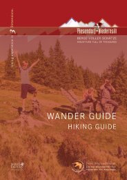
Hacklsee im Mühlbachtal<br />
Vom <strong>Wander</strong>infopoint der Dorfstraße, Weg Nr. 1 und Schattbergstraße<br />
bis zur Jausenstation Burgeck folgen. Von hier<br />
führt der Pionier-/Vitalisweg und danach der <strong>Wander</strong>weg Nr.<br />
722 vorbei and der Schaunbergalm bis zur Schaunberg Mitteralm.<br />
Nun auf den <strong>Wander</strong>steig wechseln und diesem über<br />
die Hackl Hochalm bis zum Hacklsee folgen. Der Abstieg<br />
erfolgt über dieselbe Strecke oder entlang der Forststraße.<br />
<strong>Wander</strong>taxi: Oberkofler Touristik Tel. +43 6549 20421<br />
Gehzeit ab Schaunbergalm ca. 4,5 Std. (hin & retour)<br />
Achtung! Ein Grundmaß an Trittsicherheit & Schwindelfreiheit<br />
ist erforderlich.<br />
m<br />
2500<br />
2000<br />
1500<br />
Jausenstation Burgeck<br />
Schaunbergalm<br />
Hacklsee<br />
Asphalt<br />
Weg | way<br />
Pfad | path<br />
Schaunbergalm<br />
1000<br />
500<br />
km<br />
5<br />
10<br />
15<br />
20<br />
From the hiking info point, follow the Dorfstraße, path no. 1 and<br />
Schattbergstraße to the Burgeck snack station. From here, take<br />
the Pionierweg/Vitalisweg and then the hiking path no. 722 past<br />
the Schaunbergalm to the Schaunberg Mitteralm. Now change<br />
to the hiking trail and follow it over the Hackl Hochalm to the<br />
Hacklsee. The descent is via the same route or via the forest road.<br />
Hiking taxi: Oberkofler Touristik tel. +43 6549 20421<br />
Hiking time from Schaunbergalm approx. 4.5 hrs. (there & back)<br />
Attention! A basic level of surefootedness & head of heights is<br />
required!<br />
4,4 km<br />
12,0 km<br />
7,0 km<br />
23,4 km<br />
8 - 10 h<br />
Start & Ziel:<br />
<strong>Wander</strong>infopoint Niedernsill<br />
1.467 m<br />
Start & destination:<br />
1.467 m<br />
Hiking info point Niedernsill