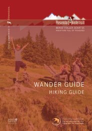
Wander Guide 2021

Create successful ePaper yourself
Turn your PDF publications into a flip-book with our unique Google optimized e-Paper software.
Maurerkogel<br />
Von der Hochsonnbergalm auf den Pinzgauer Spaziergang<br />
aufsteigen und dem Weg Nr. 19 in Richtung Schmittenhöhe bis<br />
zur Kesselscharte folgen. Hier links abbiegen und entlang dem<br />
Grat bis zum Gipfel wandern. Nun geht es in weiter bis zum<br />
Rohrertörl und anschließend führt der <strong>Wander</strong>weg Nr. 719,<br />
Pinzgauer Spaziergang wieder retour zum Ausgangspunkt.<br />
Aufstiegszeit bis zur Hochsonnbergalm: ca. 3 bis 4 Stunden<br />
<strong>Wander</strong>taxi: Oberkofler Touistik Tel. +43 6549 20421<br />
Start from the Hochsonnbergalm and ascend to the Pinzgauer<br />
Spaziergang, trail no. 19. Then follow it in the direction of the<br />
Schmittenhöhe until you reach the Kesselscharte. Turn left and<br />
hike along the ridge up to the summit. Now the hike continues<br />
to Rohrertörl. From there, the hiking trail no. 719, Pinzgauer<br />
Spaziergang trail leads back to the Hochsonnbergalm.<br />
Ascent to the Hochsonnbergalm: approx. 3 to 4 hours.<br />
Hiking taxi: Oberkofler Touristik tel. +43 6549 20421<br />
m<br />
2100<br />
2000<br />
1900<br />
1800<br />
Weg | way<br />
Pfad | path<br />
Hochsonnbergalm<br />
1,6 km<br />
4,9 km<br />
Maurerkogel<br />
Hochsonnbergalm<br />
6,5 km<br />
2,5 - 3,5 h<br />
318 m<br />
318 m<br />
Start & Ziel:<br />
Hochsonnbergalm Piesendorf<br />
Start & destination:<br />
Hochsonnbergalm Piesendorf<br />
km 1 2 3 4 5 6