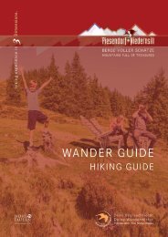
Wander Guide 2021

You also want an ePaper? Increase the reach of your titles
YUMPU automatically turns print PDFs into web optimized ePapers that Google loves.
Niedernsiller Hochsonnberg<br />
Ausgehend vom <strong>Wander</strong>infopoint der Straße bis zum Kreisverkehr<br />
folgen und links weiter durch die Unterführung in die<br />
Steindorfer Straße. Nun führen die <strong>Wander</strong>wege 3 und 5 bis<br />
Hochprack. Auf die Forststraße wechseln, bei der Weggabelung<br />
nach dem Schranken links abbiegen und dem Weg Nr.<br />
13 über die Bachrainalm bis zur Hochsonnberghütte folgen.<br />
Der Abstieg erfolgt entlang den <strong>Wander</strong>wegen 13 und 748A<br />
(Steinbachriedel) bis Hochprack und anschließend geht es entlang<br />
der Aufstiegsroute wieder retour zum Ausgangspunkt.<br />
Hinweis: Die Hochsonnberghütte ist nicht bewirtschaftet!<br />
Begrenzte Parkmöglichkeiten Hochprack - Gehzeit ca. 6,5 Std.<br />
m<br />
2000<br />
Asphalt<br />
Weg | way<br />
Pfad | path<br />
1500<br />
1000<br />
500<br />
km 2 4 6 8 10 12 14 16<br />
Starting from the hiking info point, follow the road to the roundabout<br />
and continue left through the underpass into Steindorfer<br />
Straße. Now follow the hiking path nos. 3 and 5 uphill<br />
to Hochprack. Change to the forest road, turn left at the fork in<br />
the road after the barrier and take trail no. 13 via the Bachrainalm<br />
to the Hochsonnberghütte hut. The descent is along<br />
hiking trails 13 and 748A (Steinbachriedel) to Hochprack<br />
and then hike back to the starting point via the ascent route.<br />
Note: The Hochsonnberghütte isn‘t managed!<br />
Limited parking Hochprack - hiking time approx. 6.5 hours<br />
9,8 km<br />
3,7 km<br />
5,6 km<br />
19,1 km<br />
7 - 8 h<br />
Start & Ziel:<br />
<strong>Wander</strong>infopoint Niedernsill<br />
1.106 m<br />
Start & destination:<br />
1.106 m<br />
Hiking info point Niedernsill<br />
18