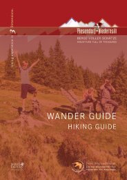
Wander Guide 2021

Create successful ePaper yourself
Turn your PDF publications into a flip-book with our unique Google optimized e-Paper software.
Hochsonnbergalm<br />
Ausgehend vom Parkplatz der Schiliftstraße talwärts bis zur<br />
Brücke folgen und links abbiegen. Weiter geht es entlang der<br />
Straße und am Weg Nr. 5 nach Friedensbach. An der Weggabelung<br />
links halten, ein kurzes Stück der Straße bis zur nächsten<br />
Brücke folgen und nochmals links abbiegen. Danach am<br />
<strong>Wander</strong>weg 5 & 5A Richtung Gosen wandern. Nun führt<br />
der Weg Nr. 17 übern Angerberg bis zur Hochsonnbergalm.<br />
Der Rückweg erfolgt über die <strong>Wander</strong>wege 18A, 18 und 6A.<br />
Weitere Abstiegsmöglichkeiten: über die Aufstiegsroute wieder<br />
retour oder am Weg Nr. 1A zur Pinzgauer Hütte wandern<br />
und weiter talwärts am Weg Nr. 1B nach Piesendorf.<br />
<strong>Wander</strong>taxi: Oberkofler Touristik Tel. +43 6549 20421<br />
m<br />
2000<br />
Hochsonnbergalm<br />
Asphalt<br />
Weg | way<br />
Pfad | path<br />
1500<br />
1000<br />
500<br />
km 2 4 6 8 10 12 14<br />
Starting from the car park follow the Schiliftstraße downhill<br />
to the bridge and turn left. Continue along the road and trail<br />
no. 5 to Friedensbach. Keep left at the fork in the road, walk a<br />
short distance along the road to the next bridge and turn left<br />
again. Now follow hiking trail no. 5 & 5A in the direction of<br />
Gosen and then path no. 17 leads over Angerberg to the Hochsonnbergalm.<br />
The way back is via hiking trails 18A, 18 and 6A.<br />
Further descent options: hike via the ascent route back to<br />
Walchen or via path no. 1A to the Pinzgauer Hütte and<br />
from there further downhill on path no. 1B to Piesendorf.<br />
Hiking taxi: Oberkofler Touristik tel. +43 6549 20421<br />
3,6 km<br />
9,7 km<br />
2,7 km<br />
16 km<br />
6 - 7 h<br />
Start & Ziel:<br />
Parkplatz Walchen<br />
1.052 m<br />
Start & destination:<br />
1.065 m<br />
Parking lot Walchen<br />
16