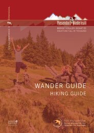
Wander Guide 2021

You also want an ePaper? Increase the reach of your titles
YUMPU automatically turns print PDFs into web optimized ePapers that Google loves.
NIEDERNSILL<br />
Hochprack - Röderlehen 3 5<br />
11,8 km<br />
4 - 5 h<br />
651 m<br />
651 m<br />
Start & Ziel: <strong>Wander</strong>infopoint<br />
Start & destination: Hiking info point<br />
Schwierigkeit: mittel<br />
Difficult: medium<br />
Technik<br />
Technique<br />
Kondition<br />
Stamina<br />
Erlebnis<br />
Experience<br />
Landschaft<br />
Landscape<br />
Vom Ausgangspunkt der Straße bis zum<br />
Kreisverkehr und weiter bergwärts dem<br />
Weg Nr. 3 & 5 bis Hochprack folgen. An<br />
der Weggabelung nach dem Schranken geradeaus<br />
weiter und entlang der Forststraße<br />
bis Röderlehen wandern. Unterhalb vom<br />
Bauernhof, in der Kurve rechts auf den<br />
<strong>Wander</strong>weg wechseln und diesem über<br />
Gitschen wieder retour zum Start folgen.<br />
From the starting point, follow the road to<br />
the roundabout and continue uphill along<br />
trail no. 3 & 5 to Hochprack. At the fork<br />
in the road after the barrier, walk straight<br />
ahead along the forest road to Röderlehen.<br />
Below the farm, in the left-hand bend turn<br />
right onto the hiking trail and follow it via<br />
Gitschen and Ematen back to the start.<br />
111<br />
Rundweg Katzsteinalm 5 5 A 19 748<br />
14,1 km<br />
5 - 6 h<br />
1.025 m<br />
1.025 m<br />
Start & Ziel: <strong>Wander</strong>infopoint<br />
Start & destination: Hiking info point<br />
Schwierigkeit: mittel<br />
Difficult: medium<br />
Technik<br />
Technique<br />
Kondition<br />
Stamina<br />
Erlebnis<br />
Experience<br />
Landschaft<br />
Landscape<br />
Vom Ausgangspunkt der Straße in nördlicher<br />
Richtung bis Ematen folgen. Weiter<br />
bergwärts am <strong>Wander</strong>weg Nr. 5, vorbei an<br />
Röderlehen und danach entlang der Forststraße<br />
Richtung Hochprack wandern.<br />
Rechts halten, auf Weg Nr. 5A wechseln<br />
und diesem über die Katzsteinalm sowie<br />
Gitschalm bis zur Weggabelung folgen.<br />
Nochmals rechts abbiegen und über die<br />
Wege 19, 748 & 5 geht‘s wieder retour.<br />
From the starting point, follow the road<br />
northwards via Steindorf to Ematen. Walk<br />
further uphill along trail no. 5 to Röderlehen<br />
and then along the forest road in the<br />
direction of Hochprack. Keep to the right,<br />
change to trail no. 5A and follow this via<br />
the Katzsteinalm and Gitschalm to the fork<br />
in the trail. Turn right again and hike back<br />
along trails 19, 748 & 5 to the starting point.