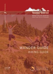
Wander Guide 2021

You also want an ePaper? Increase the reach of your titles
YUMPU automatically turns print PDFs into web optimized ePapers that Google loves.
NIEDERNSILL<br />
Ortsrunde Jesdorf - Mühlbach - Aisdorf<br />
2<br />
1<br />
1 A<br />
6,1 km<br />
1,5 - 2 h<br />
115 m<br />
115 m<br />
Start & Ziel: <strong>Wander</strong>infopoint<br />
Start & destination: Hiking info point<br />
Schwierigkeit: leicht<br />
Difficult: easy<br />
Technik<br />
Technique<br />
Kondition<br />
Stamina<br />
Erlebnis<br />
Experience<br />
Landschaft<br />
Landscape<br />
Vom <strong>Wander</strong>infopoint dem Weg Nr. 2<br />
(Jesdorferstraße/Tauernradweg) bis zum<br />
Hundeabrichteplatz folgen. Rechts abbiegen<br />
und weiter bis zur Weggabelung spazieren.<br />
Hier geradeaus weiter und bei der<br />
nächsten Kreuzung nochmals geradeaus.<br />
Kurz danach rechts auf Weg Nr. 1 wechseln<br />
und diesem bis Aisdorf folgen. Der<br />
Weg Nr. 1A führt wieder retour zum Start.<br />
From the hiking info point follow trail no. 2<br />
(Jesdorferstraße/Tauern cycle path) to the<br />
dog training area. Turn right and continue<br />
to the fork in the road. Walk straight ahead<br />
here and straight ahead again at the next<br />
crossroads. Shortly afterwards, turn right<br />
onto trail no. 1 and follow it to Aisdorf. Then<br />
path no. 1A leads back to the starting point.<br />
Rundweg Naglköpfl - Walchen - Niedernsill 6 2<br />
9,1 km<br />
2,5 - 3 h<br />
350 m<br />
350 m<br />
Start & Ziel: <strong>Wander</strong>infopoint<br />
Start & destination: Hiking info point<br />
Schwierigkeit: leicht<br />
Difficult: easy<br />
Technik<br />
Technique<br />
Kondition<br />
Stamina<br />
Erlebnis<br />
Experience<br />
Landschaft<br />
Landscape<br />
Vom Start der Straße Richtung Steindorf<br />
folgen und rechts weiter bis Ematen. Bei<br />
der Abzweigung auf den Naglköpfl-weg,<br />
Weg Nr. 6 wechseln und entlang dem bis<br />
zum Naglköpfl wandern. Weiter geht es<br />
am Kulturlandschaftsweg nach Walchen.<br />
In der Kehlbachgasse rechts in Bachweg<br />
einbiegen und nochmals rechts weiter in<br />
die Fuchshausstraße. Nun dem <strong>Wander</strong>weg<br />
und dann Weg Nr. 2 retour folgen.<br />
From the start, follow the road in the direction<br />
of Steindorf and continue to the<br />
right until you reach Ematen. At the junction,<br />
change to the Naglköpflweg, trail no.<br />
6 and hike along it to the Naglköpfl. Continue<br />
along the Kulturlandschaftsweg trail<br />
to Walchen. In the Kehlbachgasse turn right<br />
into Bachweg and right again into Fuchshausstraße.<br />
Now follow the hiking trail and<br />
then trail no. 2 back to the starting point.