Adirondack Sports November 2020
IN THIS ISSUE: 1 – Mountain Biking: Saratoga Shredders Girls Mountain Bike Club 3 – Running & Walking: Thanksgiving Reimagined 5 – News Briefs &From the Publisher 7 – Hiking & Snowshoeing: The Secret Views of Eleventh Mountain 9 – Athlete Profile: Skiing with Jack & Cathy Hay 12-14 – CALENDAR OF EVENTS: Find Races, Events & Things to Do! 15 – Hiking, XC Skiing & Snowshoeing: Prepare for Late Fall Adventures 16 – Alpine Skiing: Willard, The Little Mountain That Could 17 – Bicycling: Winter Riding Options 19 – Run, Walk & Snowshoe: Best Bets for Winter Running
IN THIS ISSUE:
1 – Mountain Biking: Saratoga Shredders Girls Mountain Bike Club
3 – Running & Walking: Thanksgiving Reimagined
5 – News Briefs &From the Publisher
7 – Hiking & Snowshoeing: The Secret Views of Eleventh Mountain
9 – Athlete Profile: Skiing with Jack & Cathy Hay
12-14 – CALENDAR OF EVENTS: Find Races, Events & Things to Do!
15 – Hiking, XC Skiing & Snowshoeing: Prepare for Late Fall Adventures
16 – Alpine Skiing: Willard, The Little Mountain That Could
17 – Bicycling: Winter Riding Options
19 – Run, Walk & Snowshoe: Best Bets for Winter Running

Create successful ePaper yourself
Turn your PDF publications into a flip-book with our unique Google optimized e-Paper software.
HIKING & SNOWSHOEING<br />
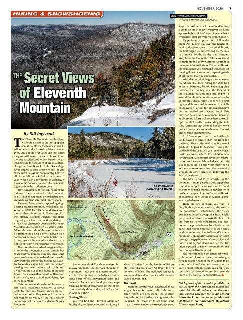
VIEW FROM ELEVENTH MOUNTAIN.<br />
NOVEMBER <strong>2020</strong> 7<br />
PHOTOS & MAP BY BILL INGERSOLL<br />
THE Secret Views<br />
of Eleventh<br />
Mountain<br />
By Bill Ingersoll<br />
The Eleventh Mountain trailhead on<br />
NY Route 8 is one of the most popular<br />
access points for the Siamese Ponds<br />
Wilderness, and it is used by hikers almost<br />
every week of the year. Although this is not<br />
a region with many routes to choose from,<br />
the one excellent route that begins here –<br />
leading over the shoulder of the mountain,<br />
along the East Branch of the Sacandaga<br />
River, and up to the Siamese Ponds – is one<br />
of the most enjoyable backcountry hikes in<br />
all of the <strong>Adirondack</strong> Park, at any time of<br />
year. Within just a few hours of walking, it<br />
transports you from the side of a busy state<br />
highway into the wilderness core.<br />
However, despite the official name of the<br />
trailhead, there is no trail to the mountain<br />
itself. This is an important point that has been<br />
known to confuse some first-time visitors!<br />
Eleventh Mountain is a sprawling ridge<br />
bearing multiple summits, with a peak elevation<br />
of 3,290 feet. Its name derives from<br />
the fact that it is located in Township 11 of<br />
the Totten & Crossfield Purchase, one of the<br />
original great land transactions dating to<br />
1771. (It has alternately been called Cataract<br />
Mountain due to the high-elevation waterfall<br />
on the east side of the mountain, visible<br />
from Route 8 near Bakers Mills.) It is an<br />
enormous mountain – if not in height, then<br />
in pure geographic sprawl – and even I cannot<br />
claim to have explored the whole thing.<br />
However, the bushwhack suggested here<br />
is not to the mountain’s main summit, but<br />
to its southwesternmost bump. This is the<br />
portion of the mountain that dominates the<br />
view from the trail to the Sacandaga Lean-<br />
To. For a while as you hike that trail, you are<br />
passing very near the foot of its cliffs, and<br />
if you venture out to the banks of the East<br />
Branch Sacandaga River north of Diamond<br />
Brook you’re sure to find an enticing view<br />
of the mountain.<br />
This outermost shoulder of the mountain<br />
has a maximum elevation of about<br />
2,500 feet, but my favorite views are well<br />
below that point. They overlook the interior<br />
wilderness valley of the East Branch<br />
Sacandaga, all the way to a distant Snowy<br />
Mountain.<br />
Diamond Brook<br />
East Branch Sacandaga River<br />
But lest you think I’m about to describe<br />
an easy hike to the shoulder of a shoulder of<br />
a mountain – not even the main summit! –<br />
let’s be clear: getting to the ledges requires<br />
some basic off-trail navigation skills, and<br />
there are places where the slopes are steep.<br />
But as wilderness bushwhacks go, this one is<br />
comparatively short, and it makes for a fine<br />
snowshoe outing.<br />
Getting There<br />
You will find the Eleventh Mountain<br />
Trailhead prominently located on Route 8<br />
Eleventh Mountain<br />
P<br />
EAST BRANCH<br />
SACANDAGA RIVER.<br />
about 3.7 miles from the hamlet of Bakers<br />
Mills and 13.5 miles from NY Route 30 near<br />
the town of Wells. The trailhead can easily<br />
accommodate a dozen cars, and it is maintained<br />
all year long.<br />
The Trail<br />
There are several ways to approach these<br />
ledges, but unfortunately all of the most<br />
direct routes are very steep. The shortest<br />
way to the top is to bushwhack right from the<br />
trailhead. This entails a 730-foot climb in the<br />
space of just 0.5 mile – an exceedingly steep<br />
8<br />
slope that will seem all the more daunting<br />
if the rocks are at all icy. I’ve never tried this<br />
approach, but a friend who did came back<br />
with a less-than-glowing recommendation.<br />
My preferred approach is to follow the<br />
main DEC hiking trail over the height-ofland<br />
and down toward Diamond Brook,<br />
the first major stream crossing on the trek<br />
to Siamese Ponds. As the trail wanders<br />
away from the foot of the cliffs, leave it and<br />
contour around the westernmost corner of<br />
the mountain, well above Diamond Brook.<br />
From this angle you can then bushwhack up<br />
the ridgeline to the summit, exploring each<br />
of the ledges that you encounter.<br />
With that in mind, begin the same way<br />
everybody else does: hiking the state trail<br />
as far as Diamond Brook. Following blue<br />
markers, the trail begins at the far end of<br />
the trailhead parking area and begins to<br />
ascend the shoulder of the mountain within<br />
minutes. Steep, rocky slopes rise to your<br />
right, and these are often covered in icefalls<br />
in the winter. Parts of the old roadbed have<br />
become eroded from water runoff. This<br />
may not be a new development, because<br />
as observant hikers will note there are multiple<br />
parallel roadbeds ascending the hillside,<br />
suggesting that the road builders were<br />
quick to cut a new route whenever the old<br />
one became unsatisfactory.<br />
At 0.5-mile you reach the height-ofland,<br />
having ascended 260 feet from the<br />
trailhead. After a brief level stretch, the trail<br />
gradually begins to descend. During the<br />
cold half of the year, you can see the ledges<br />
on the southwest side of Eleventh Mountain<br />
to your right. Assuming that your sole destination<br />
are the tops of those ledges, then this<br />
is a good point to begin your bushwhack;<br />
as the trail veers away from the mountain,<br />
stray in the other direction, following the<br />
foot of the slopes.<br />
The idea is not to go straight up the<br />
mountain – most people would agree that<br />
way is too steep. Instead, you want to round<br />
its corner, seeking out the somewhat more<br />
moderate slopes closer to Diamond Brook.<br />
Then double-back up the mountain, parallel<br />
to the ledge tops.<br />
There are two openings you want to<br />
find, both with open views to the west –<br />
the panorama is astonishing! The views<br />
extend southwest through the Square Falls<br />
gorge and northwest across the heart of<br />
the Siamese Ponds Wilderness. You cannot<br />
see the ponds themselves, but you can<br />
guess their location in relation to the nearby<br />
landmarks County Line, Puffer and Siamese<br />
mountains. Humphrey Mountain is visible<br />
through the gap between County Line and<br />
Puffer, and beyond it you can see the distinctive<br />
profile of Snowy Mountain on the<br />
horizon, over 16 miles away.<br />
The recommended descent is essentially<br />
the same. However, since you no longer<br />
need to hug the edge of the mountain to be<br />
sure you’ve found the best views, you can<br />
keep a short distance to the east and enjoy<br />
the open hardwood forest that extends<br />
much of the way to Diamond Brook.<br />
Bill Ingersoll of Barneveld is publisher of<br />
the Discover the <strong>Adirondack</strong>s guidebook<br />
series: hiketheadirondacks.com. For more<br />
info, consult Discover the South Central<br />
<strong>Adirondack</strong>s or his recently-published<br />
50 Hikes in the <strong>Adirondack</strong> Mountains<br />
(Countryman Press).