UNHCR's ELIGIBILITY GUIDELINES FOR ASSESSING THE ...
UNHCR's ELIGIBILITY GUIDELINES FOR ASSESSING THE ...
UNHCR's ELIGIBILITY GUIDELINES FOR ASSESSING THE ...

You also want an ePaper? Increase the reach of your titles
YUMPU automatically turns print PDFs into web optimized ePapers that Google loves.
In addition, there is also a continuing criminal threat of car-jacking and robbery. 794<br />
According to the US Department of State,<br />
“(t)ravel in or through Ramadi and Fallujah; in and between al-Hillah, al-Basrah, Kirkuk,<br />
and Baghdad; between the International Zone and Baghdad International Airport; and<br />
from Baghdad to Mosul is particularly dangerous.”<br />
The fact that Iraqis continue to travel should not be taken as an indicator that traveling is<br />
safe. Rather, Iraqis travel out of necessity and avoid traveling as much as possible.<br />
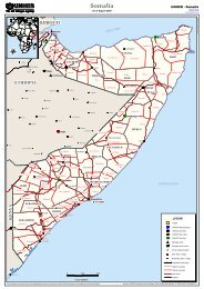
The following provides an overview of Iraq’s main roads and possible security issues.<br />
- Baghdad Western South route<br />
This road leads from Baghdad to the Jordanian, Syrian and Saudi borders passing<br />
through the Governorates of Al-Anbar, Babylon, Najaf, Kerbala, Qadissiyah and<br />
Al-Muthanna. This road divides into two 50 kms south of Baghdad with one road<br />
(Highway No. 10) leading further to the Jordanian and Syrian borders and the other<br />
(Highway No. 31) leading to the Saudi Arabian border crossing of ‘Ar’ar.<br />
The first 50kms are considered very dangerous, and the road remains very risky<br />
towards the Jordanian/Syrian borders passing by Fallujah and Ramadi with armed<br />
conflict and crime being a daily occurrence. The road leading further South to the<br />
Saudi border is considerably safer, except for the route towards the town of Hilla<br />
(Triangle of Death) and south of it. In late March 2007, the town of Haswa, 50 km<br />
south of Baghdad, saw an increase in violence and the road was closed for two days.<br />
Further South, the road as such is mostly safe but security incidents are common in<br />
the cities it passes, in particular Najaf and Kerbala. Traveling after sunset is not<br />
safe. Increased security incidents also occur during Shi’ite religious festivities when<br />
Sunni insurgents target Shi’ite pilgrims on their way to the holy cities of Najaf and<br />
Kerbala. 795 On the route between Nassriyah and Basrah frequent incidents of carjacking<br />
have taken place. It was also reported that the fact that cars try to avoid<br />
approaching MNF convoys often lead to car accidents.<br />
- Baghdad Eastern South route<br />
This road (Highway No. 6) passes from Baghdad through the Governorates of Al-<br />
Wassit, Missan and Basrah towards the Kuwaiti border. This road is generally<br />
considered safer than the Western route although sporadic roadside bombs are being<br />
reported and car-jackings are a common occurrence.<br />
- Baghdad Western North route<br />
This road passes from Baghdad through the Governorates of Salah Al-Din and<br />
Ninewa (Highway No. 1) and further North to Dahuk and finally the Turkish<br />
border. The road is extremely dangerous between Baghdad and the town of Tikrit<br />
794<br />
FCO, Travel Advise by Country – Iraq, see above footnote 790; USDOS, Travel Warning – Iraq, see<br />
above footnote 790.<br />
795<br />
See, for example, Brian Murphy, Bombers Massacre Shiite Pilgrims in Iraq, AP, 7 March 2007,<br />
http://abcnews.go.com/International/wireStory?id=2928921.<br />
154