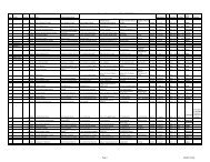
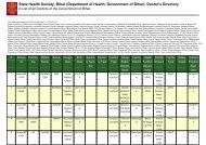
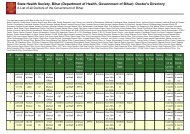
District Health Action Plan - STATE HEALTH SOCIETY-----BIHAR
District Health Action Plan - STATE HEALTH SOCIETY-----BIHAR
District Health Action Plan - STATE HEALTH SOCIETY-----BIHAR

You also want an ePaper? Increase the reach of your titles
YUMPU automatically turns print PDFs into web optimized ePapers that Google loves.
Geographical Profile of Saran <strong>District</strong><br />
Location <strong>District</strong> is situated between 25°36' & 26°13' North latitude and 84°24' & 85°15' East<br />
longitude in the southern part of Saran Division of North Bihar<br />
Geographical<br />
Area<br />
Physiography<br />
2641 Sq. Kms<br />
<strong>District</strong> is entirely constituted of plains. Alluvial plains along the big rivers, region of<br />
uplands away from the rivers and not subject to floods and Diara areas in the beds of<br />
the great rivers. The soil of the district is alluvial. No mineral of economic value is<br />
found in the district.<br />
Climate Generally tropical in nature with hot summer and cold winter.<br />
Rainfall<br />
Forest<br />
Agriculture<br />
rainy season lasts till the end of September. Maximum rainfall occurs in the month of<br />
July & August. normal rainfall is 1140 mm.<br />
In the remote past, district was densely wooded and presumably derived its name from<br />
its forest, is completely devoid of any forest now. Cultivated land is dotted over with<br />
bamboo groves, palm trees & mango orchids.<br />
Very good potential for Agriculture and allied activities. Agriculture has continued to<br />
be the main occupation in the district and also the main source of livelihood of the<br />
people.<br />
Main Crops Rice and Maize. About 47.1% of the net sown area. Maize is produced through mix<br />
cropping with Potato.<br />
Irrigation<br />
Animal<br />
Husbandry<br />
Rains are the main source of irrigation. Irrigation through watering of fields on one<br />
hand and draining of water logged on the other. Many schemes for irrigation.<br />
Very important for district. Cattle of local breeds. Buffalos, Goats, are very common.<br />
Industry no large-scale industries or heavy industry a. But at present they all are closed.<br />
Minerals No minerals of any economic importance are found in the district.<br />
River System Ganga, Ghaghra and Gandak rivers encircle the district. Out of twenty blocks in the<br />
districts, six blocks viz Sonepur, Dighwara, Revelganj, Chapra, Manjhi and Dariyapur<br />
are flood prone. There are six partially flood affected blocks Viz. Garkha, Parsa,<br />
Marhoura, Amnaur, Jalalpur, and Ekma. The remaining blocks are free from floods.<br />
Road &<br />
Transport<br />
Administrative<br />
Divisions<br />
Tourisms<br />
Places in<br />
Saran<br />
Good network of roads. The district headquarter Chapra is situated on the National<br />
Highway 19, which provides road link between east and west (Hazipur to Gazipur).<br />
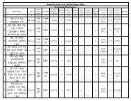
3 subdivisions with 20 blocks. The district has 330 Gram Panchayats constituting<br />
1767 villages. The district has 5 numbers of statutory towns with one Nagar Parishad<br />
and 4 Nagar Panchayats. Subdivision:- Chapra, Marhaurah and Sonepur<br />
Saran district has been a hub of interfaith interaction with all the religion, resulting in<br />
places of tourist interests and cultural fairs. Sonepur is one of the most Internationally<br />
famous tourist centre due to having the large fair.<br />
12 | P a g e D i s t r i c t H e a l t h A c t i o n P l a n 2 0 1 2 - 1 3 D H S , S a r a n