Adventure Magazine Issue 220
Issue 220: June/July Winter 2020
Issue 220: June/July
Winter 2020

You also want an ePaper? Increase the reach of your titles
YUMPU automatically turns print PDFs into web optimized ePapers that Google loves.
Know before you go:<br />
Even experienced trampers have<br />
come unstuck in this extreme<br />
environment. The weather can be<br />
especially unpredictable in winter,<br />
with big temperature drops and heavy<br />
downpours that can make streams and<br />
rivers dangerous or impassable. There<br />
are also volcanic hazards, so it’s vital to<br />
obey all warnings and signs.<br />
Check in with the Visitor Centre at<br />
Whakapapa for advice, forecasts<br />
and hut bookings. The Walks in<br />
and around Tongariro National Park<br />
brochure has further detail on these<br />
tramps and others in the national park.<br />
A topographical map is essential for<br />
longer walks.<br />
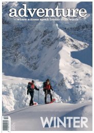
Above and right: Hiking in the Tongariro National Park - Image compliments of Visit Ruapehu<br />
Day Walks:<br />
Tongariro National<br />
Park’s spectacular day<br />
walks venture into all<br />
corners and will keep<br />
you occupied for a<br />
solid week.<br />
Tongariro Alpine Crossing:<br />
7–8 hr<br />
Snowy surrounds and low crowds make winter a fabulous time to hike<br />
the Crossing, but you’ll need to go with a guide unless you’re an expert<br />
alpine tramper. This challenging track starts at 1120m and winds up<br />
the Mangatepopo Valley to the saddle between Mts Tongariro and<br />
Ngauruhoe. You’re into crater territory as you reach the crossing’s<br />
highpoint at 1886m.<br />
The descent is via a rock scree track to the vivid Emerald Lakes/<br />
Ngā Rotopounamu (greenstone-hued lakes) and Blue Lake/Te Waiwhakaata-o-te-Rangihiroa<br />
(Rangihiroa’s mirror). The track then sidles<br />
around the northern slope of Tongariro to descend via a zigzag track<br />
past Ketetahi Shelter and down to the road end.<br />
Attempting the Tongariro<br />
Alpine Crossing in winter is a<br />
very different experience than<br />
during other times of the year.<br />
From May to October, snow<br />
and ice mean alpine skills<br />
and experience are essential.<br />
Therefore, the best and safest<br />
way to enjoy the Crossing in<br />
its full alpine glory is to go with<br />
guide. Two Tongariro Alpine<br />
Crossing guiding companies,<br />
with decades of experience<br />
and approved by the<br />
Department of Conservation,<br />
operate from National Park<br />
Village - Adrift Tongariro and<br />
<strong>Adventure</strong> Outdoors Tongariro,<br />
and can guide you safely<br />
across this incredible, yet risky,<br />
wintery wonderland.<br />
Multi Day Walks:<br />
Round the Mountain Track:<br />
Tama Lakes Tramping Track:<br />
Lake Surprise:<br />
There are two classic multi-day tramps in<br />
Tongariro: the Northern Circuit Great Walk<br />
and the Round the Mountain Track.<br />
The Tongariro Northern Circuit:<br />
3–4 days<br />
One of New Zealand’s Great Walks, this tramp can<br />
be completed in the winter months by experienced<br />
trampers with all the right gear, preparation and<br />
favourable conditions.<br />
It’s usually started in Whakapapa Village and walked<br />
clockwise, winding first to Mangetepopo Hut to join the<br />
Alpine Crossing with its craters and surreal lakes. The<br />
circuit then continues down the spectacular Oturere<br />
Valley and around Mt Ngauruhoe’s foothills towards<br />
historic Waihohonu Hut.<br />
The final day sees you hike over Tama saddle between<br />
Ngauruhoe & Ruapehu – with a possible detour to<br />
the must-see Tama Lakes – before heading past the<br />
tumbling Taranaki Falls to return to Whakapapa Village.<br />
4–6 days<br />
A more remote and advanced adventure than the<br />
Northern Circuit, this unforgettable tramp traverses<br />
a variety of landscapes from mountain beech forest,<br />
tussock country and alpine herbfields, to desert lands<br />
and glacial river valleys.<br />
As much of the track passes through alpine terrain,<br />
it is recommended that winter trips are completed<br />
with a guide. The rest of the year it can be walked by<br />
experienced, well-prepared trampers when the weather<br />
is favourable.<br />
Starting at Whakapapa, it heads clockwise around Mt<br />
Ruapehu taking in many of the park’s most famous<br />
sights: Taranaki Falls, Tama Lakes, Waitonga Falls,<br />
Lake Surprise and Silica Rapids. It also takes in the<br />
Rangipo desert, with its barren and peculiar beauty. Six<br />
huts along the way each have their own character, too.<br />
5–6 hr<br />
This memorable walk starts at Whakapapa Village<br />
along the Taranaki Falls Track with all its interesting<br />
landforms and gushing streams. At the top of Taranaki<br />
Falls, the track branches off through rolling tussock<br />
country and alpine herbfields towards Tama Lakes.<br />
Beyond the lower lake viewpoint (1240m), the track<br />
climbs steeply to a 1440m-viewpoint of the upper lake.<br />
Tama Lakes occupy several old explosion craters on<br />
Tama Saddle between Ruapehu and Ngauruhoe. In<br />
winter, it’s essential to check in with Whakapapa Visitor<br />
Centre on the current trail conditions.<br />
Old Blyth Tramping Track:<br />
4–5 hr<br />
Starting on the Ohakune Mountain Road, this track partly<br />
follows the historic route up Mt Ruapehu through significant<br />
vegetation including mixed beech forest. When Blyth Track<br />
was constructed in the early 1900s, much of the route was<br />
through alpine bog; you can see the remains of ‘corduroy’<br />
laid across the muddy surface. Return the same way or<br />
walk out to the Mountain Road via the Waitonga Falls/<br />
Round the Mountain Tramping Track, and then walk back<br />
down the road – the views are epic.<br />
5 hrs<br />
Few walks are as aptly named this, but a hidden lake<br />
isn’t the only surprise on this amazing day out. Starting<br />
high on Mt Ruapehu, this advanced trail heads through<br />
epic boulder fields, bluffs and scree slopes with alpine<br />
gardens boasting a colourful array of flowers, lichens and<br />
moss. A climb into Mangaturuturu Valley follows a waterfall<br />
flowing over an ancient lava cascade. You’ll also pass a<br />
70-year-old tramping hut, nestled amongst stunted forest.<br />
Ever-changing views stretch from Ruapehu’s peak to the<br />
edges of the volcanic plateau. The lake itself is tranquil and<br />
untouched. The trail starts 20 minutes’ drive up Ohakune<br />
Mountain Road.<br />
Historic Waihohonu Hut:<br />
3 hr<br />
It’s well worth the half-day return hike to see this historic<br />
hut, especially as you’ll get up close to the strange terrain<br />
of the Rangipo desert, deep beech forest, and tussockland.<br />
Built in 1903/04 as a stopover for stagecoaches, it’s<br />
constructed of a double layer of corrugated iron with a layer<br />
of pumice between. No longer used for accommodation, the<br />
hut is preserved as an historical building and is classified by<br />
the Heritage New Zealand. This track starts off the Desert<br />
Rd (SH1), signposted 35km south of Turangi.<br />
54//WHERE ACTIONS SPEAK LOUDER THAN WORDS/#<strong>220</strong> ADVENTUREMAGAZINE.CO.NZ 55