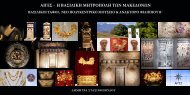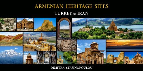
ARMENIAN HERITAGE SITES IN TURKEY AND IRAN

Create successful ePaper yourself
Turn your PDF publications into a flip-book with our unique Google optimized e-Paper software.
<strong>ARMENIAN</strong> <strong>HERITAGE</strong> <strong>SITES</strong><br />
<strong>TURKEY</strong>&<strong>IRAN</strong><br />
<strong>ARMENIAN</strong> <strong>HERITAGE</strong> <strong>SITES</strong><br />
DIMITRA STAS<strong>IN</strong>OPOULOU
ARMENIA’S<strong>HERITAGE</strong><strong>IN</strong><strong>TURKEY</strong><br />
<strong>ARMENIAN</strong><strong>HERITAGE</strong><strong>IN</strong><strong>IRAN</strong><br />
<strong>ARMENIAN</strong><strong>HERITAGE</strong><strong>AND</strong>UNESCO<br />
byVaheGabrielyan<br />
Armenians take pride in quoting famous foreigners<br />
who have called Armenia a museum under open<br />
skies. Throughout a long and turbulent history, of<br />
which at least over 3000 years have been<br />
documentedtovariousextentinhistoricaltextsand<br />
maps and even more in myths and folklore,<br />
Armenians have succeeded in building kingdoms<br />
and even empires with highly advanced social<br />
structures and infrastructure, magnificent religious<br />
andseculararchitectureandartsandcraftsthatstill<br />
fascinate, amaze and enchant. Quite a lot of that<br />
tangible heritage has been destroyed in wars and<br />
naturaldisastersandmuchofwhatremainshasbeen<br />
covered in the dust of time and is yet to be<br />
unearthed.<br />
Evenwhathassurvivedcanstillbeatestimonytothe<br />
astonishing talent and skills of a nation that has<br />
outlived many formidable hostile empires and<br />
hordes of different eras. This book is neither a<br />
textbookofArmenianhistory,norofArmenianarts,<br />
neitherisitastudyofthoserealms.Thisissimplyan<br />
attemptataguidetothatpartofArmeniancultural<br />
heritage that has already been recognized and<br />
appreciated by the rest of the family of nations.<br />
Unlike that of many other nations, Armenian<br />
heritage is not limited to the physical boundaries of<br />
the state currently representing the nation, the<br />
Republic of Armenia. At different times, Armenian<br />
kingdoms and empires of the past centuries covered<br />
anareaseveraltimesthatoftheRepublictoday,and<br />
even as their country continued to reduce in size,<br />
Armenians continued to live on their ancestral<br />
lands, despite campaigns of massacres and genocide<br />
against them. Therefore, monuments of Armenian<br />
architecture can be found in abundance in<br />
neighboring countries on historically Armenian<br />
lands and in countries where Armenian Diaspora<br />
communitieshavebeenestablished.<br />
Armenian Heritage and UNESCO: Volume 1<br />
and2–2017<br />
https://www.amazon.com/Armenian-Heritage-<br />
UNESCO-1-2/dp/9939018541<br />
In July 2016, the ancient Armenian city of Ani, now<br />
in eastern Turkey, was inscribed as a UNESCO<br />
World Heritage site. For Armenians, a people still<br />
living under the shadow of what they regard as "the<br />
firstgenocideofthe20 th century”carriedoutagainst<br />
their ancestors who lived under the Ottoman<br />
Empire, the listing ensures protection of a small but<br />
treasured piece of their heritage. But a visit to the<br />
region today shows that, outside the walls of Ani,<br />
what remains of Armenian culture in Turkey is in<br />
dangerofdisappearingentirely.<br />
The eastern part of the current territory of the<br />
RepublicofTurkeyispartoftheancestralhomeland<br />
of the Armenians. Along with the Armenian<br />
population, during and after the Armenian<br />
Genocide the Armenian cultural heritage was<br />
targetedfordestructionbytheTurkishgovernment.<br />
Of the several thousand churches and monasteries<br />
(usually estimated from two to three thousand) in<br />
the Ottoman Empire in 1914, today only a few<br />
hundred are in still standing in some form; most of<br />
these are in danger of collapse. Those that continue<br />
tofunctionaremainlyinIstanbul.<br />
Most of the properties formerly belonging to<br />
Armenians were confiscated by the Turkish<br />
government and turned into military posts,<br />
hospitals, schools and prisons. Many of these were<br />
also given to Muslim migrants or refugees who had<br />
fled from their homelands during the Balkan Wars.<br />
Thelegaljustificationfortheseizureswasthelawof<br />
Emval-i Metruke (Law of Abandoned Properties),<br />
which legalized the confiscation of Armenian<br />
propertyiftheownerdidnotreturn.<br />
https://www.rferl.org/a/armenian-heritage-in-turkey/<br />
28029302.html<br />
InthemuseumsofTehran,Isfahan,andTabriz,more<br />
than 3.000 ancient parchment manuscripts in the<br />
Armenian language are stored. Thanks to the efforts<br />
oftheIraniangovernment,3Armenianarchitectural<br />
monuments in Iran were inscribed in the UNESCO<br />
WorldHeritageList.TheseweretheSt.Thaddeusand<br />
St. Stepanos monasteries, as well as the Chapel of<br />
Dzordzor. Their significance lies in their<br />
architectural representation of the exchanges<br />
between the regional cultures including Byzantine,<br />
Orthodox, and Persian. The monasteries have<br />
withstood numerous calamities, both human and<br />
natural, throughout the centuries. St. Stepanos,<br />
arguablythemostwell-knownofthethree,standsin<br />
a canyon past the twists and bends of the Aras River<br />
ontheAzerbaijanborder.<br />
The Armenian quarter of New Julfa in Isfahan, was<br />
established in 1606 as an Armenian quarter by the<br />
edictofShahAbbasIfromtheSafaviddynasty.Over<br />
150,000 Armenians were moved there from the<br />
older Julfa (also known as Jugha or Juła)<br />
in Nakhichavan. Iranian sources state that the<br />
Armenians came to Iran fleeing the Ottoman<br />
Empire's persecution. Nevertheless, historical<br />
records indicate that the residents of Julfa were<br />
treated well by Shah Abbas in the hopes that their<br />
resettlement in Isfahan would be beneficial to Iran<br />
due to their knowledge of the silk trade. The Holy<br />
Savior Cathedral, also known the Church of the<br />
Saintly Sisters, is located here. It is commonly<br />
referredtoastheVank,whichmeans"monastery"or<br />
"convent"intheArmenianlanguage.<br />
www.wikipedia
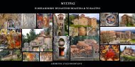
ANI–‘THECITYOF1001CHURCHES’<br />
AniisaruinedmedievalArmeniancitynowsituated<br />
in Turkey's province of Kars, next to the closed<br />
borderwithArmenia.<br />
Between 961 and 1045, it was the capital of<br />
theBagratidArmeniankingdomthatcoveredmuch<br />
of present-day Armenia and eastern Turkey. Ani<br />
stoodonvarioustraderoutesanditsmanyreligious<br />
buildings, palaces, and fortifications were amongst<br />
the most technically and artistically advanced<br />
structuresintheworld. Atitsheight,Aniwasoneof<br />
the world's largest cities,with a possible population<br />
of100,000.<br />
Renowned for its splendor, Ani was sacked by the<br />
Mongols in 1236. Ani never recovered from a<br />
devastating 1319 earthquake, and was gradually<br />
abandoneduntilitwaslargelyforgottenbythe17 th c.<br />
Ani is a widely recognized cultural, religious, and<br />
national heritage symbol for Armenians.According<br />
to Razmik Panossian, Ani is one of the most visible<br />
and ‘tangible’ symbols of past Armenian greatness<br />
andhenceasourceofpride.<br />
In 1064, a large Seljuk army under Alp<br />
ArslanattackedAni;afterasiegeof25days,they<br />
capturedthecityandslaughtereditspopulation.<br />
An account of the sack and massacres in Ani is<br />
given by the Arab historian Sibt ibn al-Jawzi,<br />
whoquotesaneyewitnesssaying:<br />
“Putting the Persian sword to work, they spared no<br />
one... One could see there the grief and calamity of<br />
everyageofhumankind.Forchildrenwereravished<br />
from the embraces of their mothers and mercilessly<br />
hurled against rocks, while the mothers drenched<br />
them with tears and blood... The city became filled<br />
from one end to the other with bodies of the slain<br />
and[thebodiesoftheslain]becamearoad.[...]The<br />
army entered the city, massacred its inhabitants,<br />
pillagedandburnedit,leavingitinruinsandtaking<br />
prisoner all those who remained alive...The dead<br />
bodies were so many that they blocked the streets;<br />
one could not go anywhere without stepping over<br />
them.Andthenumberofprisonerswasnotlessthan<br />
50,000 souls. I was determined to enter city and see<br />
the destruction with my own eyes. I tried to find a<br />
streetinwhichIwouldnothavetowalkoverthe<br />
corpses;butthatwasimpossible.”<br />
In 1072, the Seljuks sold Ani to the Shaddadids, a<br />
Muslim Kurdish dynasty. The Shaddadids generally<br />
pursued a conciliatory policy towards the city's<br />
overwhelmingly Armenian and Christian<br />
populationandactuallymarriedseveralmembersof<br />
the Bagratid nobility. Whenever the Shaddadid<br />
governance became too intolerant, however, the<br />
population would appeal to the Christian Kingdom<br />
ofGeorgiaforhelp.TheGeorgianscapturedAnifive<br />
timesbetween1124and1209.<br />
The Mongols unsuccessfully besieged Ani in 1226,<br />
but in 1236 they captured and sacked the city,<br />
massacring large numbers of its population. Under<br />
the Mongols the Zakarids continued to rule Ani, as<br />
thevassalsoftheGeorgianmonarch.<br />
Bythe14 th century,thecitywasruledbyasuccession<br />
of local Turkish dynasties, including the Jalayrids<br />
andtheKaraKoyunlu(BlackSheepclan)whomade<br />
Ani their capital. It was ruined by an earthquake in<br />
1319. Tamerlane captured Ani in the 1380s. On his<br />
death the Kara Koyunlu regained control but<br />
transferred their capital to Yerevan. In 1441 the<br />
Armenian Catholicosate did the same. The<br />
PersianSafavidsthenruledAniuntilitbecamepart<br />
of the Turkish Ottoman Empire in 1579. A small<br />
town remained within its walls at least until the<br />
middle of the seventeenth century, but the site was<br />
entirelyabandonedby1735whenthelastmonksleft<br />
themonasteryintheVirgin'sFortressorKizkale.<br />
MONUMENTSATANI<br />
All the structures at Ani are constructed using the<br />
localvolcanicbasalt,asortoftufastone.Itiseasily<br />
carvedandcomesinavarietyofvibrantcolors,from<br />
creamy yellow, to rose-red, to jet black. The most<br />
importantsurvivingmonumentsareasfollows.<br />
THECATHEDRAL<br />
Also known as Surp Asdvadzadzin (the Church of<br />
the Holy Mother of God), its construction was<br />
startedintheyear989,underKingSmbatII,andwas<br />
only finished in 1001. The design of the cathedral<br />
was the work of Trdat, the most celebrated architect<br />
of medieval Armenia. The cathedral is a domed<br />
basilica (the dome collapsed in 1319). The interior<br />
containsseveralprogressivefeatures(suchastheuse<br />
of pointed arches and clustered piers) that give to it<br />
theappearanceofGothicarchitecture(astylewhich<br />
theAnicathedralpredatesbyseveralcenturies)<br />
. SURPSTEPHANOSCHURCH<br />
There is no inscription giving the date of its<br />
construction,butanedictinGeorgianisdated1218.<br />
The church was referred to as "Georgian". During<br />
this period "Georgian" did not simply mean an<br />
ethnic Georgian, it had a denominational meaning<br />
and would have designated all those in Ani who<br />
professed the Chalcedonian faith, mostly<br />
Armenians. Although the Georgian Church<br />
controlled this church, its congregation would have<br />
mostlybeenArmenians.<br />
THECHURCHOF<br />
STGREGORYOFTIGRANHONENTS<br />
This church, finished in 1215, is the best-preserved<br />
monumentatAni.Itwasbuiltduringtheruleofthe<br />
Zakarids and was commissioned by the wealthy<br />
Armenian merchant Tigran Honents. Its plan is of a<br />
typecalledadomedhall.Infrontofitsentranceare<br />
the ruins of a narthex and a small chapel that are<br />
from a slightly later period. The exterior of the<br />
church is spectacularly decorated. Ornate stone<br />
carvings of real and imaginary animals fill the<br />
spandrelsbetweenblindarcadesthatrunsaroundall<br />
four sides of the church. The interior contains an<br />
important and unique series of frescoes cycles that<br />
depict two main themes. In the eastern third of the<br />
church is depicted the Life of Saint Gregory the<br />
Illuminator, in the middle third of the church is<br />
depicted the Life of Christ. Such extensive fresco<br />
cyclesarerarefeaturesinArmenianarchitecture–it<br />
isbelievedthattheseoneswereexecutedbyGeorgian<br />
artists,andthecyclealsoincludesscenesfromthelife<br />
ofSt.Nino,whoconvertedtheGeorgiansto<br />
Christianity. In the narthex and its chapel survive<br />
fragmentary frescoes that are more Byzantine in<br />
style.
THECHURCHOFTHEREDEEMER<br />
This church was completed shortly after the year<br />
1035. It had a unique design: 19-sided externally, 8-<br />
apsed internally, with a huge central dome set upon<br />
a tall drum. It was built by Prince Ablgharib<br />
PahlavidtohouseafragmentoftheTrueCross.The<br />
churchwaslargelyintactuntil1955,whentheentire<br />
easternhalfcollapsedduringastorm<br />
THECHURCHOFSTGREGORY<br />
OFTHEABUGHAMRENTS<br />
Thissmallbuildingprobablydatesfromthelate10 th<br />
century. It was built as a private chapel for the<br />
Pahlavuni family. Their mausoleum, built in 1040<br />
andnowreducedtoitsfoundations,wasconstructed<br />
against the northern side of the church. The church<br />
hasacentralizedplan,withadomeoveradrum,and<br />
theinteriorhassixexedras.<br />
K<strong>IN</strong>GGAGIK'S<br />
CHURCHOFSTGREGORY<br />
Also known as the Gagikashen, this church was<br />
constructed between the years 1001 and 1005 and<br />
intended to be a recreation of the celebrated<br />
cathedral of Zvartnots at Vagharshapat. Nikolai<br />
Marr uncovered the foundations of this remarkable<br />
building in 1905 and 1906. Before that, all that was<br />
visible on the site was a huge earthen mound. The<br />
designer of the church was the architect Trdat. The<br />
church is known to have collapsed a relatively short<br />
time after its construction and houses were later<br />
constructedontopofitsruins.Trdat'sdesignclosely<br />
followsthatofZvartnotzinitssizeandinitsplan(a<br />
quatrefoil core surrounded by a circular<br />
ambulatory).<br />
THECHURCHOFTHE<br />
HOLYAPOSTLES<br />
The date of its construction is not known, but the<br />
earliestdatedinscriptiononitswallsisfrom1031.It<br />
was founded by the Pahlavuni family and was used<br />
by the archbishops of Ani (many of whom belonged<br />
tothatdynasty).Ithasaplanofatypecalledan<br />
inscribed quatrefoil with corner chambers. Only<br />
fragments remain of the church, but a narthex with<br />
spectacularstonework,builtagainstthesouthsideof<br />
the church, is still partially intact. It dates from the<br />
early 13 th century. A number of other halls, chapels,<br />
and shrines once surrounded this church: Nicholas<br />
Marr excavated their foundations in 1909, but they<br />
arenowmostlydestroyed.<br />
THEMOSQUEOFMANUCHIHR<br />
The mosque is named after its presumed founder,<br />
Manuchihr, the first member of the Shaddadid<br />
dynasty that ruled Ani after 1072. The oldest<br />
surviving part of the mosque is its still intact<br />
minaret. It has the Arabic word Bismillah ("In the<br />
nameofGod")inKuficletteringhighonitsnorthern<br />
face. The prayer hall, half of which survives, dates<br />
fromalaterperiod(the12 th or13 th century).In1906<br />
the mosque was partially repaired in order for it to<br />
house a public museum containing objects found<br />
duringNicholasMarr'sexcavations.<br />
THECITADEL<br />
At the southern end of Ani is a flat-topped hill once<br />
knownasMidjnaberd(theInnerFortress). Ithasits<br />
own defensive walls that date back to the period<br />
whentheKamsarakandynastyruledAni(7 th century<br />
AD).NicholasMarrexcavatedthecitadelhillin1908<br />
and 1909. He uncovered the extensive ruins of the<br />
palaceoftheBagratidkingsofAnithatoccupiedthe<br />
highestpartofthehill.Alsoinsidethecitadelarethe<br />
visible ruins of three churches and several<br />
unidentified buildings. One of the churches, the<br />
"churchofthepalace"istheoldestsurvivingchurch<br />
in Ani, dating from the 6th or 7th century. Marr<br />
undertook emergency repairs to this church, but<br />
most of it has now collapsed – probably during an<br />
earthquakein1966 .<br />
THECITYWALLS<br />
Alineofwallsthatencircledtheentirecitydefended<br />
Ani. The most powerful defences were along the<br />
northernsideofthecity,theonlypartofthesitenot<br />
protected by rivers or ravines. Here the city was<br />
protectedbyadoublelineofwalls,themuchtaller<br />
inner wall studded by numerous large and closely<br />
spaced semicircular towers. Contemporary<br />
chroniclers wrote that King Smbat (977–989) built<br />
these walls. Later rulers strengthened Smbat's walls<br />
bymakingthemsubstantiallyhigherandthicker,and<br />
byaddingmoretowers.Armenianinscriptionsfrom<br />
the 12 th and 13 th century show that private<br />
individualspaidforsomeofthesenewertowers.The<br />
northern walls had three gateways, known as the<br />
LionGate,theKarsGate,andtheDvinGate(also<br />
knownastheChequer-BoardGatebecauseofapanel<br />
ofredandblackstonesquaresoveritsentrance)<br />
OTHERMONUMENTS<br />
There are many other minor monuments at Ani.<br />
These include a convent known as the Virgins'<br />
chapel; a church used by Chalcedonian Armenians;<br />
the remains of a single-arched bridge over the Arpa<br />
river; the ruins of numerous oil-presses and several<br />
bath houses; the remains of a second mosque with a<br />
collapsedminaret;apalacethatprobablydatesfrom<br />
the 13 th century; the foundations of several other<br />
palaces and smaller residences; the recently<br />
excavatedremainsofseveralstreetslinedwithshops;<br />
etc.<br />
CAVEVILLAGE<br />
Directly outside of Ani, there was a settlement-zone<br />
carved into the cliffs. It may have served as "urban<br />
sprawl" when Ani grew too large for its city walls.<br />
Today, goats and sheep take advantage of the caves'<br />
cool interiors. One highlight of this part of Ani is a<br />
cave church with frescos on its surviving walls and<br />
ceiling.<br />
AniislistedinUNESCO’sWorldHeritageSites.<br />
https://en.wikipedia.org/wiki/Ani
MonasteryofHripsimianVirgins
Lion’sGate
ThechurchofStGregoryofTigranHonents
TheCathedral
ThemosqueofManuchihr
StGregoryoftheAbughamrentsis
CHURCHOFTHEHOLYREDEEMER
AncientArmeniancavedwellings
DOĞUBAYAZIT<br />
URARTIANCASTLE<br />
Doğubayazıt is the easternmost district of Turkey,<br />
bordering with Iran, at an elevation of 1625 m. The<br />
town is a settlement with a long history and lies<br />
15kmsouthwestofMountArarat.<br />
The area has had a rich history with monuments<br />
dating back to the time of the Kingdom of Urartu<br />
(over 2700 years ago). The Kingdom of Urartu was<br />
centered in modern-day eastern Turkey, southwest<br />
Armenia, and northwestern Iran. Urartu enjoyed<br />
considerable political power in the region in the 9 th<br />
and 8 th centuries BCE. Similar to Assyrian in<br />
language and culture, their capital was Tushpa<br />
(modern-day Van, Turkey). Before the Ottoman<br />
Empire the site was referred to by its Armenian<br />
name Daruynk. In the 4 th century the Sasanians<br />
failedtocapturetheArmenianstrongholdandroyal<br />
treasury at Daruynk. Princes of the Bagratid<br />
dynasty of Armenia resided at Daruynk and rebuilt<br />
the fortress into its present configuration with<br />
multiplebaileysandtowerscarefullyintegratedinto<br />
the ascending rock outcrop. When King Gagik<br />
Arcruni reoccupied the fortress in 922 A.D. it<br />
became the seat of a bishop. It was subsequently<br />
conquered and reconquered by Persians,<br />
Armenians, Byzantines, and Seljuks, all of whom<br />
wouldhaveusedtheplaintorestandrecoupduring<br />
their passages across the mountains. The castle of<br />
Daruynk was repaired many times throughout this<br />
history, although it is now named after the Turkish<br />
warlord Celayırlı Şehzade Bayazıt Han who ordered<br />
oneoftherebuildings(in1374).Ultimately,thetown<br />
was renamed Beyazit itself in the 16 th century.The<br />
widelydispersedvillageofBayazit,wasoriginallyan<br />
Armenian settlement and populated by Kurds in<br />
1930andYazidisfromtheSerhatregion.Butin1930<br />
the Turkish army destroyed it in response to the<br />
AraratRebellion.Anewtownwasbuiltintheplain<br />
below the old site in the 1930s (hence the new name<br />
"Doğubayazıt",whichliterallymeans"EastBeyazıt").<br />
ISHAKPASHAPALACE<br />
Ishak Pasha Palace, on the Silk Route near the<br />
Iranian frontier, is situated on a high and vast<br />
platform of strategic importance on an area of 7600<br />
squaremeters.<br />
Built over an entire century by generations of the<br />
Pashafamily,theMiddleEastern-inspiredarchesand<br />
domesofthesprawlingpalacehavesurvivedforover<br />
400 years. Sitting near the Iranian border, the<br />
architectural design of the palace is heavily<br />
influencedbyitsneighboringArmenianandIranian<br />
cultures. The palace was outfitted with a dizzying<br />
arrayoffacilitiesandamenitiesincludingabakery,a<br />
mosque, dungeons, and even a harem, all with a<br />
central heating system. It has been decorated with<br />
white and black stones and consists of 366 rooms,<br />
twocourtyards,mosque,tombsandharem.<br />
The landscape around Ishak Pasha Palace is<br />
hauntingly beautiful located in this majestic<br />
mountainous region. This area boasts of several<br />
mountains: Ararat, Little Ararat, Tendürek Dagi,<br />
Kaletepe,Agridagi,andGöllertepe.<br />
AftertheTopkapıPalace,itisthemostfamouspalace<br />
in Turkey and was depicted on the reverse of the<br />
Turkish100newlirabanknoteof2005–2009.
KARS<br />
KarsProvince(Turkish:Karsili,Armenian: Կարսի<br />
նահանգ) is a province of Turkey, located in the<br />
northeasternpartofthecountry.Itsharespartofits<br />
closed border with Armenia. The provincial capital<br />
isthecityofKars.<br />
In ancient times, Kars was part of the province of<br />
AraratintheKingdomofArmenia.Thefirstknown<br />
peoplewerethefollowersofVanand(Վանանդ),for<br />
whom Kars was their main settlement and fortress.<br />
In928,KarsbecamethecapitalofBagratidArmenia.<br />
In968,thecapitalofArmeniawasmovedtoAni,but<br />
Kars remained the capital of the feudal principality<br />
of Vanand. As a result of the Russo-Turkish War of<br />
1877to1878,theprovinceofKarswasincorporated<br />
into the Russian Empire as part of the militarily<br />
administered Kars Oblast and remained so until<br />
1918.<br />
Forashorttime(928-961)Karswasthecapitalofthe<br />
Armenian Bagratid kingdom and it was during this<br />
timethattheCathedral,nowknownastheChurchof<br />
the Apostles, was built. Shortly after the Bagratid<br />
capitalwastransferredtoAni,Karsbecame(in963)<br />
aseparateindependentkingdomknownasVannadthe<br />
Armenian name for the Kars region. This<br />
kingdomwastooutlivethatofAni.<br />
After the Seljuk Turks captured Ani, the last<br />
Armenian king of Kars ceded his city to the<br />
Byzantine Empire in 1064, getting in return the city<br />
of Amasya and lands in northern Cilicia. The<br />
Byzantines were no more successful in defending<br />
KarsthantheywerewithAni,andsoonlostittothe<br />
Turks (in 1071). In 1236 the Mongols occupied the<br />
region. As with other places, they probably gave a<br />
great deal of autonomy to the majority Armenian<br />
population: an Armenian prince is known to have<br />
beengoverningKarsin1284.<br />
ThegradualRussianconquestoftheCaucasusinthe<br />
18 th century, led to an influx of Muslim migrants,<br />
especially Circassians. Kars became a strategic and<br />
heavily fortified border town protecting the Turkish<br />
Empire's eastern frontier and the road to Erzurum.<br />
The Russians occupied Kars in 1828, in 1855 and<br />
againin1877.<br />
AsubstantialpartoftheMuslimpopulationleftafter<br />
1877, choosing not to live under Russian rule. The<br />
Armenians gradually moved into a new district of<br />
European-style buildings built on a grid plan to the<br />
south of the old medieval city, and most of the old<br />
city walls were demolished. There was a large influx<br />
ofArmeniansfromotherpartsofRussiancontrolled<br />
Armenia, as well as Armenians fleeing the<br />
oppressionandmassacresoftheOttomanEmpire.<br />
By 1918 the Turkish army was cutting a swathe of<br />
destruction across the newly declared Republic of<br />
Armenia,capturingKarsinApril1918andreaching<br />
BakuontheCaspianSea.<br />
In November 1920 the Bolsheviks annexed the little<br />
that was left of the Armenian republic. With<br />
Armenia now under Soviet "protection" the Turks<br />
ceased their advance and even withdrew from some<br />
captured territory, including Alexandropol. The<br />
Bolsheviks wanted good relations with Turkey, and<br />
in 1921 they signed the "Treaty of Kars" ceding the<br />
townofKarstoTurkey.
VAN–ANCIENTK<strong>IN</strong>GDOM<br />
OFURARTU<br />
Urartu is a geographical region commonly used as<br />
theexonymfortheIronAgekingdomalsoknownby<br />
the modern rendition of its endonym, the Kingdom<br />
of Van, centered around Lake Van in the historic<br />
Armenian Highlands (present-day eastern<br />
Anatolia).Thekingdomrosetopowerinthemid-9 th<br />
century BC, but went into gradual decline and was<br />
eventually conquered by the Iranian Medes in the<br />
early 6 th century BC. The geopolitical region would<br />
re-emerge as Armenia shortly after. The peoples of<br />
Urartu are the earliest identifiable ancestors of the<br />
Armenians. Urartu at its zenith had a profound<br />
culturalinfluenceonitsneighborsreachingasfaras<br />
AsiaandEurope.<br />
ThenameUrartu(Armenian: Ուրարտու;Assyrian:<br />
טָרָרֲא Hebrew: māt Urarṭu; Babylonian: Urashtu;<br />
Ararat) comes from Assyrian sources. Urartu is<br />
cognatewiththeBiblicalArarat,AkkadianUrashtu,<br />
and Armenian Ayrarat. The name Kingdom of Van<br />
(Urartian:Biai,Biainili; Վանի թագավորություն)<br />
isderivedfromtheUrartiantoponymBiainili,which<br />
was probably pronounced as Vanele, and called Van<br />
(Վան) in Old Armenian, hence the names<br />
"KingdomofVan"or"VannicKingdom".<br />
TheKingdomofVanwasdestroyedin590BCandby<br />
the late 6 th century, the Satrapy of Armenia had<br />
replaced it. Little is known of what happened to the<br />
region between the fall of the Kingdom of Van and<br />
the appearance of the Satrapy of Armenia.<br />
According to historian Touraj Daryaee, during the<br />
Armenian rebellion against the Persian king Darius<br />
I in 521 BC, some of the personal and topographic<br />
names attested in connection with Armenia or<br />
Armenians were of Urartian origin, suggesting that<br />
UrartianelementspersistedwithinArmeniaafterits<br />
fall.IntheBehistunInscription(c.522BC),aswellas<br />
theXVInscription(c.486–465BC),refertoArmenia<br />
and Armenians as synonyms of Urartu and<br />
Urartians. The toponym Urartu did not disappear,<br />
however, as the name of the province of Ayrarat in<br />
the center of the Kingdom of Armenia is believed to<br />
beitscontinuum.<br />
AccordingtoHerodotus,theAlarodians(Alarodioi),<br />
presumably a variation of the name Urartian/<br />
Araratian, were part of the 18 th Satrapy of the<br />
AchaemenidEmpireandformedaspecialcontingent<br />
in the grand army of Xerxes I. According to this<br />
theory, the Urartians of the 18 th Satrapy were<br />
subsequentlyabsorbedintotheArmeniannation.<br />
In a study published in 2017, the complete<br />
mitochondrial genomes of 4 ancient skeletons from<br />
Urartu were analyzed alongside other ancient<br />
populations found in modern-day Armenia and<br />
Artsakh spanning 7,800 years. The study shows that<br />
modern-dayArmeniansarethepeoplewhohavethe<br />
leastgeneticdistancefromthoseancientskeletons.<br />
The written language that the kingdom's political<br />
elite used is retroactively referred to as Urartian,<br />
which is attested in numerous cuneiform<br />
inscriptions throughout Armenia and eastern<br />
Turkey. It is unknown what language was spoken by<br />
the peoples of Urartu at the time of the existence of<br />
the Kingdom of Van, but there is evidence of<br />
linguistic contact between the proto-Armenian<br />
language and the Urartian language at an early date<br />
(sometime between the 3rd—2nd millennium BC),<br />
occurringpriortotheformationofthekingdom.
MOUNTNEMROUT–TOMBOF<br />
ANTIOCHUSITHEOSOFCOMMAGENE<br />
Nemrut or Nemrud (Turkish: Nemrut Dağı;<br />
Kurdish: Çiyayê Nemrûdê; Armenian: Նեմրութ<br />
լեռ) is a 2,134 m-high mountain in southeastern<br />
Turkey, notable for the summit where a number of<br />
large statues are erected around what is assumed to<br />
bearoyaltombfromthe1 st c.BC.<br />
Antiochus I Theos Dikaios Epiphanes<br />
Philorhomaios Philhellen (Ancient Greek: Ἀντίοχος<br />
ὁ Θεὸς Δίκαιος Ἐπιφανὴς Φιλορωμαῖος Φιλέλλην,<br />
meaning"Antiochos,thejust,eminentgod,friendof<br />
Romans and friend of Greeks", c. 86 BC – 31 BC,<br />
ruled70BC–31BC)wasKingoftheGreco-Iranian<br />
KingdomofCommageneandthemostfamousking<br />
of that kingdom. In 1987, Mount Nemrut was<br />
declaredaWorldHeritageSitebyUNESCO .<br />
When the Seleucid Empire was defeated by the<br />
Romansin190BCattheBattleofMagnesiaitbegan<br />
to fall apart and new kingdoms were established on<br />
itsterritorybylocalauthorities.Commagene,oneof<br />
the Seleucid successor states, occupied a land<br />
between the Taurus mountains and the Euphrates.<br />
ThestateofCommagenehadawiderangeof<br />
cultureswhichleftitsleaderfrom62BC–38BC<br />
Antiochus I Theos to carry on a peculiar dynastic<br />
religious program, which included not only Greek<br />
and Iranian deities but Antiochus and his family as<br />
well. This religious program was very possibly an<br />
attempt by Antiochus to unify his multiethnic<br />
kingdom and secure his dynasty's authority.<br />
Antiochussupportedthecultasapropagatorof<br />
happinessandsalvation.<br />
ORONTIDSOFCOMMAGENE<br />
In Nemrut Dagi, opposite the statues of Gods there<br />
arealongrowofpedestals,onwhichstoodthesteles<br />
oftheGreekancestorsofAntiochos.Atarightangle<br />
tothisrowstoodanotherrowofsteles,depictinghis<br />
Orontid and Achaemenid ancestors. From these<br />
steles the ones of Darius and Xerxes are well<br />
preserved.Antiochosexpendedgreatefforttoensure<br />
that everyone was aware that he was related to the<br />
dynasty of the King of Kings, Darius I, by the<br />
marriage of princess Rhodogune to his ancestor<br />
Orontes. The father of Rhodogune was the Persian<br />
king, Artaxerxes. In 401 BC Artaxerxes defeated his<br />
youngerbrother,whotriedtodeposehim.Becauseof<br />
the help Artaxerxes received from Orontes—his<br />
military commander and satrap of Armenia—he<br />
gavehisdaughterinmarriagetohim.<br />
The Orontid dynasty, also known by their native<br />
nameEruandidorYervanduni(Armenian: Երվանդ<br />
ունի), was a hereditary Armeniandynasty and the<br />
rulersofthesuccessorstatetotheIronAgekingdom<br />
of Urartu (Ararat). The Orontids established their<br />
supremacy over Armenia around the time of<br />
the Scythian and Median invasion in the 6 th century<br />
BC.MembersoftheOrontiddynastyruledArmenia<br />
intermittently during the period spanning the 6 th<br />
centuryBCtoatleastthe2 nd century BC, first as<br />
client kings or satraps of<br />
the Median and Achaemenid empires who<br />
established an independent kingdom after the<br />
collapseoftheAchaemenidempire,andlateraskings<br />
of Sophene and Commagene who eventually<br />
succumbedtotheRomanEmpire.
APHRODISIAS–CARIA,<strong>TURKEY</strong><br />
AphrodisiasislocatedinsouthwesternTurkey,inthe<br />
fertile valley formed by the Morsynus River, in the<br />
ancient region of Caria and was founded as a citystate<br />
in the early 2 nd century BC. Because the city<br />
sharedacloseinterestinthegoddessAphroditewith<br />
Sulla, Julius Caesar and the emperor Augustus,<br />
Aphrodisias came to have a close relationship with<br />
Rome. It obtained a privileged ‘tax-free’ political<br />
status from the Roman senate, and developed a<br />
strong artistic, sculptural tradition during the<br />
ImperialPeriod.<br />
The sanctuary at Aphrodisias had a distinctive cult<br />
statueofAphroditewhichdefinedthecity’sidentity.<br />
TheAphroditeofAphrodisiascombinedaspectsofa<br />
local Anatolian, archaic fertility goddess with those<br />
oftheHellenicAphrodite,goddessofloveand<br />
beauty.<br />
The proximity of the marble quarries to the city<br />
was a major reason that Aphrodisias became an<br />
outstanding high-quality production centre for<br />
marble sculpture. Sculptors from the city were<br />
famousthroughouttheRomanEmpire.Theywere<br />
well-known for virtuoso portrait sculpture and<br />
Hellenistic-style statues of gods and Dionysian<br />
figures. In late antiquity (4 th -6 th centuries AD),<br />
Aphrodisian sculptors were in great demand for<br />
marble portrait busts and statues of emperors,<br />
governors and philosophers in the major centers<br />
oftheempire–forexample,atSardis,<br />
Stratonikeia, Laodikeia, Constantinople and<br />
Rome. In this period they were the best carvers of<br />
marblestatuesoftheirday.<br />
THESTATUEOF<br />
NEROWITHARMENIA<br />
Nero supports the slumping figure of Armenia<br />
between his wide-striding legs, holding her by her<br />
upper arms. She collapses, sitting back on her left<br />
heel, her right leg stretched out in front, the foot<br />
bracedagainst,itwouldhaveseemed,thesideofthe<br />
columnframingthepanel<br />
Nerowearsashortcloakfastenedwitharound<br />
broochandabaldriccarryinganemptyscabbard.<br />
Armenia wears short, plain boots with ribbon-like<br />
ties shown on the left boot, a cloak fastened on the<br />
rightshoulder,andsoft'Phrygian'capwithsoft,freestanding<br />
peak, modelled carefully in the round. She<br />
has long, wavy hair, untied and reaching over her<br />
shoulders. Her body is naked and well realized in a<br />
compact design. The quiver and bow, normal for<br />
Armenia iconography, are shown in lower relief on<br />
thebackground,leaningagainstthesideofthepanel.<br />
Iconographically, the evocation is clearly of Achilles<br />
and Penthesilea: the striding hero with cloak and<br />
baldricsupportingtheeastern/Amazonqueen.<br />
The statue symbolizes the support of the Roman<br />
Emperor Nero to the King Tiridates the III of<br />
Armenia. In 63 AD after many defeats with the<br />
Parthians, King Tigranes resigned and the throne<br />
passed on to the Prince of Tiridates, the founder of<br />
the Arsacides dynasty of Armenia. His coronation<br />
took place in Rome by Nero himself. Returning to<br />
Armenia and having considerable help from the<br />
Romans,herebuiltthedestroyedcapitalofArmenia<br />
andnameditNeroniatohonortheRomanEmperor.
ClaudiusandBritannia<br />
NeroandArmenia
<strong>IRAN</strong>
Church of St Stepanos
ST STEPANOS
<strong>ARMENIAN</strong> MONASTIC ENSEMBLES<br />
OF<strong>IRAN</strong><br />
TheWestAzerbaijanProvinceinnorthwestIranhas<br />
a fairly sizable Christian Armenian population, so<br />
the number of churches in this area is no surprise.<br />
The three monastic ensembles, St. Thaddeus (the<br />
oldest dating back to the 7 th century), St. Stepanos,<br />
and the Chapel of Dzordzor, were listed with<br />
UNESCO in 2008. Their significance lies in their<br />
architectural representation of the exchanges<br />
between the regional cultures including Byzantine,<br />
Orthodox, and Persian. The monasteries have<br />
withstood numerous calamities, both human and<br />
natural, throughout the centuries. St. Stepanos,<br />
arguablythemostwell-knownofthethree,standsin<br />
acanyonpastthetwistsandbendsoftheArasRiver<br />
on the Azerbaijan border. These churches are still<br />
placesofpilgrimagefortheArmeniancommunity.<br />
MONASTERY OF SA<strong>IN</strong>T THADDEUS<br />
(THEBLACKCHURCHORKARAKELISA)<br />
Legendhasitthatachurchdedicatedtohimwasfirst<br />
builtonthepresentsiteinAD68.Itwasextensively<br />
rebuiltafteranearthquakedamageditin1319.Some<br />
ofthepartssurroundingthealtardatefromthe7 th c.<br />
Muchofthepresentstructuredatesfrom1811,when<br />
theQajarprinceAbbasMirzaaidedrenovationsand<br />
repairs.<br />
According to Armenian Church tradition, the<br />
Apostles Thaddeus and Bartholomew traveled<br />
through Armenia in AD 45 to preach the word of<br />
God,wheremanypeoplewereconvertedand<br />
numerous secret Christian communities were<br />
established.<br />
Armenians hold that Qara Kelisa is the world's first<br />
church and was constructed in 68 BC by one of the<br />
apostles of Jesus, Saint Thaddeus, who traveled to<br />
Armenia, then part of the Persian Empire, to preach<br />
theteachingsofChrist.<br />
The church consists of two parts: a black structure<br />
(the original structure was black, and Qara means<br />
black in Turkish), and a white structure, the main<br />
church, which was added to the original building’s<br />
westernwingin1810.<br />
THECHAPELOFCHUPAN<br />
A small, historic Armenian church building in a<br />
mountainvalleywestofJolfa,neartheArasRiverin<br />
East Azerbaijan province, built in the 16 th century<br />
andrebuiltin1836.<br />
MONASTERYOFST.STEPANOS<br />
Saint Stepanos Monastery is the second important<br />
Armenian monastery in Iran after St Thaddeus<br />
Monastery. The monastery was built in 9 th century<br />
AD,butitwasseriouslydamagedbyearthquake. So,<br />
it was refurbished in Safavid period. This monastery<br />
is respected by all Christians and almost all other<br />
religions. However, it actually belongs to Gregory<br />
Christians (Followers of Gregory the Illuminator)<br />
inhabitinginArmenia.<br />
The church's architectural style is a mixture of<br />
Urartan, Parthian, Greek, and Roman styles that<br />
came to be known as Armenian subsequent to the<br />
construction of the fantastic structures of<br />
Echmiadzin, Thaddeus, Akhtmar, and indeed<br />
Stephanos. Thischurch,whichhasfounditsplacein<br />
the hearts of Christians throughout the world and is<br />
visited annually by hundreds of Iranian and foreign<br />
tourists, is located in the abandoned village of Dare<br />
Sham,intheGechlartdistrict.
MonasteryofSaintThaddeus<br />
(TheBlackChurchorKaraKelisa)
TheChapelofChupan
MonasteryofStStepanos
<strong>ARMENIAN</strong> <strong>HERITAGE</strong> <strong>SITES</strong><br />
<strong>TURKEY</strong>&<strong>IRAN</strong><br />
<strong>TURKEY</strong>2016-2017/<strong>IRAN</strong>2019<br />
PHOTOGRAPHY&EDIT<strong>IN</strong>G<br />
Dimitra Stasinopoulou