Globerovers Magazine, July 2019
GLOBEROVERS MAGAZINE IS NO LONGER ALLOWED TO HAVE MORE THAN 3 ISSUES ON YUMPU UNLESS WE PAY (to provide revenue-generating content to Yumpu!!) SO PLEASE SEE ALL OUR ISSUES FOR FREE ON THESE MAGAZINE PLATFORMS: CALAMEO, MAGZTER, AND ON THE FREE "globerovers" APP. In this 13th issue (July 2019) of Globerovers Magazine, the feature destination is Argentina. We travel from the far north on the border with Bolivia all the way down south to Ushuaia, the gateway to the Antarctic Peninsula. We also have articles about Cyprus and Mauritius Island, Australia, Canada, and we enjoy a colourful New Year Festival with the Naga people in the remote Nagaland region of Myanmar. Photo Essays include the proboscis monkeys and orangutans in Malaysia’s Sabah State on Borneo Island, Peru’s Sacred Valley, and a boat trip down the Li River from Guilin to Yangshuo in China. Furthermore, we have traveller interviews, book reviews, and a lot more! Feedback to editor@globerovers.com. Enjoy!
GLOBEROVERS MAGAZINE IS NO LONGER ALLOWED TO HAVE MORE THAN 3 ISSUES ON YUMPU UNLESS WE PAY (to provide revenue-generating content to Yumpu!!) SO PLEASE SEE ALL OUR ISSUES FOR FREE ON THESE MAGAZINE PLATFORMS: CALAMEO, MAGZTER, AND ON THE FREE "globerovers" APP.
In this 13th issue (July 2019) of Globerovers Magazine, the feature destination is Argentina. We travel from the far north on the border with Bolivia all the way down south to Ushuaia, the gateway to the Antarctic Peninsula.
We also have articles about Cyprus and Mauritius Island, Australia, Canada, and we enjoy a colourful New Year Festival with the Naga people in the remote Nagaland region of Myanmar.
Photo Essays include the proboscis monkeys and orangutans in Malaysia’s Sabah State on Borneo Island, Peru’s Sacred Valley, and a boat trip down the Li River from Guilin to Yangshuo in China.
Furthermore, we have traveller interviews, book reviews, and a lot more!
Feedback to editor@globerovers.com. Enjoy!

You also want an ePaper? Increase the reach of your titles
YUMPU automatically turns print PDFs into web optimized ePapers that Google loves.
VOL. 7 · NO. 1, <strong>July</strong> <strong>2019</strong><br />
Journal of <strong>Globerovers</strong> Productions · GR<br />
GlobeRovers<br />
Feature Article<br />
10 Argentina - The Long Way Down<br />
Argentina is a world in one. A country that offers rose-red deserts, snow-capped mountains, massive glaciers,<br />
rugged landscapes, vast plains, great food and wine, and the best tango dancing in the world. We travel all the<br />
way from the Bolivian border at the northern tip of Argentina down to Ushuaia, the southernmost town in the<br />
world. Along the way we explore the world renowned Iguazú Falls, we dance the tango in the nation’s charming<br />
capital, we crawl close to the wildlife of Peninsula Valdés, and walk on glaciers. Viva! Argentina.<br />
ARTICLES + PHOTOS ESSAYS<br />
REGULAR SECTIONS<br />
38<br />
Malaysia’s Sabah on Borneo Island<br />
Malaysia’s untamed state of Sabah is<br />
located on Borneo Island, home to the<br />
proboscis monkeys and orangutans, as<br />
well as tiny paradise islands.<br />
52<br />
138<br />
144<br />
SPECIAL FEATURES<br />
Sensible Travel Gear<br />
Tasty Traveller’s Treats<br />
Postcards to Mommy<br />
54<br />
68<br />
Cyprus - A Divided Island<br />
The Republic of Cyprus with its predominantly<br />
Greek inhabitants lies<br />
south of the Turkish controlled North<br />
Cyprus. We explore the Republic.<br />
Mauritius - Idyllic Indian Ocean Island<br />
Located west of Madagascar, Mauritius<br />
is known for its turquoise seas, black<br />
volcanic rocks, palm trees, sugar cane<br />
fields and craggy mountain peaks.<br />
94<br />
118<br />
136<br />
142<br />
148<br />
152<br />
CONTRIBUTIONS<br />
Travel Ethics<br />
Cruising with Crocodiles in Australia<br />
Canada’s Best Hidden Train Journey<br />
Volunteering Q&A<br />
Travellers in the Spotlight<br />
Book Reviews<br />
82<br />
102<br />
124<br />
Peru’s Sacred Valley<br />
This fertile river valley, a narrow strip of<br />
land in the Peruvian Andes, has a long<br />
history and is a place of eerie natural<br />
beauty and a rich, colourful culture.<br />
A Naga New Year Festival, Nagaland<br />
In the remote northwest of Myanmar<br />
(Burma) live the Naga people. Every<br />
mid-January they come together for a<br />
colourful 3-day New Year’s festival.<br />
Boating Guilin to Yangshou, China<br />
A karst landscape dominates the course<br />
of the slow flowing Li River and its many<br />
tributaries that drain the mountenous<br />
area from Guilin to Yangshuo.<br />
Les Eclaireurs Lighthouse, Beagle<br />
Channel, Ushuaia, Argentina<br />
34<br />
66<br />
122<br />
156<br />
TOP LISTS<br />
10 Great Experiences in Argentina<br />
10 Highlights of Cyprus<br />
9 Must-do’s in South America<br />
IN THE NEXT ISSUE<br />
Japan’s Winter Wonderland<br />
The winter season in Japan is December<br />
through March. This is a time of incredibly<br />
beautiful snow-covered landscapes,<br />
steam-engulfed hot springs, and many<br />
winter acitivities for the active adventurers.<br />
A beautiful time to visit Japan.<br />
1
2 <strong>Globerovers</strong> · <strong>July</strong> <strong>2019</strong><br />
6/28-2
Editor‛s Message<br />
“Not all those who wander are lost”. J.R.R. Tolkien<br />
John Tolkien (3 Jan 1892 – 2 Sep 1973), an English writer, poet, philologist,<br />
university professor, and author of ‘The Hobbit’, and ‘Lord of the Rings’.<br />
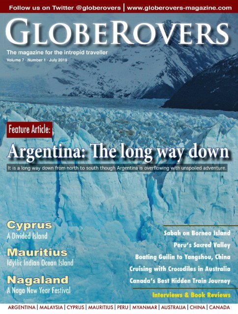
THE FRONT COVER:<br />
Perito Moreno Glacier, Patagonia, Argentina<br />
<strong>Globerovers</strong> <strong>Magazine</strong><br />
is currently a biannual magazine, available<br />
in digital and printed formats.<br />
We focus on bringing exciting destinations<br />
and inspiring photography from around<br />
the globe to the intrepid traveller.<br />
Published in Hong Kong<br />
Printed in U.S.A. and Europe<br />
WHO WE ARE:<br />
Editor-in-Chief - Peter Steyn<br />
Editorial Director - Tsui Chi Ho<br />
Graphic Designer - Peter Steyn<br />
Photographer & Writer - Peter Steyn<br />
Proofreaders - Marion Halliday<br />
Janet-Lynn Vorster<br />
Advertising - Lizzy Chitlom<br />
Distribution - Leon Ringwell<br />
FOLLOW US:<br />
www.globerovers-magazine.com<br />
www.globerovers.com<br />
facebook.com/<strong>Globerovers</strong>Mag<br />
pinterest.com/<strong>Globerovers</strong><br />
twitter.com/<strong>Globerovers</strong><br />
instagram.com/<strong>Globerovers</strong>Mag<br />
CONTACT US:<br />
editor@globerovers.com<br />
Dear Readers,<br />
In this 13th issue of <strong>Globerovers</strong> <strong>Magazine</strong>, we are pleased to bring you a variety of<br />
exciting destinations and other reading enjoyment.<br />
The feature destination is Argentina—truly a world in one! We travel from the far<br />
north on the border with Bolivia all the way down south to Ushuaia, the gateway<br />
to the Antarctic Peninsula. Along the way, we explore rusty-red valleys, spectacular<br />
waterfalls, the world’s tango capital, wildlife hotspots, glaciers, national parks,<br />
snow-covered mountains, the world’s southernmost town, and a lot more.<br />
We drive around the island of Cyprus in the Mediterranean Sea and Mauritius<br />
Island in the southern Indian Ocean, and then enjoy a colourful New Year Festival<br />
with the Naga people in the remote Nagaland region of Myanmar.<br />
Photo Essays include the proboscis monkeys and orangutans in Malaysia’s Sabah<br />
State on Borneo Island, Peru’s Sacred Valley, and a boat trip down the Li River<br />
from Guilin to Yangshuo in China.<br />
We also have our usual contributions from Canada and Australia, a Q&A about<br />
volunteering, and a 5-member panel offering their opinions about travel ethics.<br />
A special thank you to our sponsors as well as all our<br />
wonderful contributors who we introduce on page 5.<br />
Visit our website and social media. For easy access,<br />
scan the QR codes on page 7.<br />
Feedback to editor@globerovers.com.<br />
I travel so you can see the world!<br />
Peter Steyn, PhD<br />
Editor-in-Chief and Publisher<br />
Copyright © 2013-<strong>2019</strong>. All rights reserved. Reproduction of any part of this magazine<br />
is strictly prohibited without the prior written approval of the publisher. The publisher<br />
does not take responsibility for any potential inaccurate information herein.<br />
THE FRONT COVER<br />
Perito Moreno Glacier<br />
Perito Moreno Glacier in Patagonia, southern Argentina, is one<br />
of the largest, most impressive, and most accessible glaciers. The<br />
glacier’s front-face is 5 kilometres (3.1 mi) wide with an average<br />
height of 74 metres (240 ft) above the surface of Lake Argentino.<br />
3
4 <strong>Globerovers</strong> · <strong>July</strong> <strong>2019</strong>
Thanks to our Contributors<br />
In this issue<br />
CONTRIBUTORS<br />
All words and photos by Peter Steyn, except where otherwise indicated. A very special thank you to our<br />
awesome contributors in this issue. Without you, <strong>Globerovers</strong> <strong>Magazine</strong> just wouldn’t be the same!<br />
Janet-Lynn Vorster, Cape Town, South Africa (page 68)<br />
Janet is a numerologist by profession, and journalist, editor and photographer by hobby. She is<br />
the proud mother of three grown children and granny to three grandchildren. Janet is the Southern<br />
African editor for <strong>Globerovers</strong> <strong>Magazine</strong>.<br />
Marion Halliday, Adelaide, South Australia (page 118)<br />
Marion is “Red Nomad OZ”, author, blogger and Aussie traveller who loves discovering naturebased<br />
attractions and activities – and scenic loos – all over Australia. Her Aussie travel blog and<br />
published book “Aussie Loos with Views” provide inspiration for other Aussie explorers.<br />
Yrene Dee, Lumby, BC, Canada (Page 136)<br />
Yrene is the founder of BackcountryCanadaTravel.com. She was born in Switzerland, lived and<br />
worked on different continents and travelled the world before she settled in Canada. She is an<br />
entrepreneur, wilderness nut, and animal lover who prefers off-the-beaten-track places.<br />
Claire Bennett, Kathmandu, Nepal (page 142)<br />
Claire lives and works in Kathmandu, Nepal, and freelances as a trainer and consultant. She is<br />
passionate about global education, ethical travel and ensuring good intentions are put to good<br />
use. She is co-author of Learning Service: The Essential Guide to Volunteering Abroad.<br />
Matt Long, Washington DC, USA (Page 148)<br />
Matt is an experiential luxury traveller who shares his adventures with thousands of readers<br />
every day through his award winning site LandLopers.com. He has been to more than 95 countries<br />
and all 7 continents and is also the host of the weekly Explore the World Travel Podcast.<br />
Linda Ballou, Los Angeles, CA, USA (page 152)<br />
Adventure travel writer, Linda has published a collection of travel essays, including Wai-nani, A<br />
Voice From Old Hawai’i, The Cowgirl Jumped Over The Moon, Lost Angel Walkabout, and her<br />
latest book: Lost Angel Walkabout-One Traveler’s Tales. www.LindaBallouAuthor.com<br />
Mike and Anne Howard, USA (page 154)<br />
Mike & Ann Howard at HoneyTrek.com are the authors of their couples’ adventure travel book,<br />
“Ultimate Journeys for Two”. Known as the world’s longest honeymooners—seven years and<br />
counting—they are constantly travelling and exploring the world.<br />
Travel Ethics Panel (page 94)<br />
Thank you to the travel bloggers and ethics experts on our Travel Ethics Panel who were brave<br />
enough to truly speak their minds. Marion Halliday (Australia), Claire Bennett (Nepal), Matt<br />
Long (USA), Lauren Yakiwchuk (Canada), and Christine Dutaut (UK).<br />
5
The <strong>Globerovers</strong>‛ World<br />
<strong>Globerovers</strong> <strong>Magazine</strong> was created by Peter Steyn, an avid explorer who is constantly in search of the<br />
edge of the world. He will always hike the extra mile or ten to get as far off the beaten track as he can.<br />
It is his mission to discover and present the most exciting destinations for intrepid travellers. He has<br />
visited 122 countries (including territories: Greenland, Hong Kong, Macau) and is poised to explore<br />
Africa & the Pacific Islands in the near future. Peter’s home is wherever he lays down his cameras.<br />
Afghanistan<br />
Albania<br />
Andorra<br />
Argentina<br />
Armenia<br />
Australia<br />
Austria<br />
Azerbaijan<br />
Bahrain<br />
Bangladesh<br />
Belarus<br />
Belgium<br />
Belize<br />
Bolivia<br />
Bosnia-Herzegovina<br />
Brazil<br />
Brunei<br />
Bulgaria<br />
Cambodia<br />
Canada<br />
Chile<br />
China<br />
Colombia<br />
Costa Rica<br />
Croatia<br />
Cuba<br />
Cyprus<br />
Czech Rep.<br />
Denmark<br />
Ecuador<br />
Egypt<br />
El Salvador<br />
Estonia<br />
Finland<br />
France<br />
Georgia<br />
Germany<br />
Greece<br />
Greenland<br />
Guatemala<br />
Honduras<br />
Hong Kong<br />
Hungary<br />
Iceland<br />
India<br />
Indonesia<br />
Iran<br />
Ireland<br />
Israel<br />
Italy<br />
Japan<br />
Jordan<br />
Kazakhstan<br />
Kosovo<br />
Kyrgyzstan<br />
Laos<br />
Latvia<br />
Lebanon<br />
Lesotho<br />
Liechtenstein<br />
Lithuania<br />
Luxembourg<br />
Macau<br />
Macedonia<br />
Malaysia<br />
Maldives<br />
Malta<br />
Mauritius<br />
Mexico<br />
Moldova<br />
Monaco<br />
Montenegro<br />
Morocco<br />
Myanmar / Burma<br />
Namibia<br />
Nepal<br />
Netherlands<br />
New Zealand<br />
Nicaragua<br />
North Korea<br />
Norway<br />
Oman<br />
Pakistan<br />
Panama<br />
Papua New Guinea<br />
Paraguay<br />
Peru<br />
Philippines<br />
Poland<br />
Portugal<br />
Romania<br />
Russia<br />
San Marino<br />
Serbia<br />
Singapore<br />
Slovakia<br />
Slovenia<br />
South Africa<br />
South Korea<br />
Spain<br />
Sri Lanka<br />
Swaziland<br />
Sweden<br />
Switzerland<br />
Syria<br />
Taiwan<br />
Tajikistan<br />
Thailand<br />
Timor Leste (East Timor)<br />
Turkey<br />
Ukraine<br />
United Arab Emirates<br />
United Kingdom<br />
United States<br />
Uruguay<br />
Uzbekistan<br />
Vanuatu<br />
Vatican<br />
Vietnam<br />
Yemen<br />
Zambia<br />
Zimbabwe<br />
122 and counting...<br />
6 <strong>Globerovers</strong> · <strong>July</strong> <strong>2019</strong>
Follow<br />
us....<br />
Don’t hesitate to follow us to some incredible<br />
destinations. You will never be sorry you did!<br />
Use a QR reader<br />
on your smart phone<br />
facebook.com/<strong>Globerovers</strong>Mag<br />
pinterest.com/globerovers<br />
twitter.com/globerovers<br />
globerovers-magazine.com<br />
Scan this code for a<br />
FREE download of GlobeRovers app<br />
Apple Store<br />
Google Play<br />
globerovers.com<br />
Or search for “<strong>Globerovers</strong>” in your app store<br />
7
Use a QR reader on your<br />
phone to read these codes<br />
CANADA<br />
Page 136<br />
CYPRUS<br />
Page 54<br />
PERU<br />
Page 82<br />
ARGENTINA<br />
Page 10<br />
8 <strong>Globerovers</strong> · <strong>July</strong> <strong>2019</strong>
DESTINATIONS<br />
IN THIS ISSUE<br />
NAGALAND<br />
Page 102<br />
CHINA<br />
Page 124<br />
SABAH<br />
Page 38<br />
AUSTRALIA<br />
Page 118<br />
MAURITIUS<br />
Page 68<br />
9
Feature Article<br />
Argentina<br />
While the South American llama is a relative of the camel, it does not<br />
have a hump and its most closely related cousins are the alpacas, guanacos,<br />
and the vicuñas. The native people of South America have used<br />
llamas as pack animals for centuries. The guanacos and vicuñas are less<br />
likely to be domesticated but are raised for meat and their very fine wool.<br />
10 <strong>Globerovers</strong> · <strong>July</strong> <strong>2019</strong>
Argentina<br />
The Long Way Down<br />
From north to south it is a long way down but what a pleasant country to get lost in any direction.<br />
Come along as we explore the wildlife, deserts, glaciers, mountains, coastline, cities, and more!<br />
Thinking about Argentina, you may<br />
get visions of large stadiums packed<br />
with chanting football fans. You also<br />
may think of Evita Perón, or rugged<br />
snow-capped mountains, or even large chunks of<br />
BBQ’d steaks and tango dancing. Argentina is all<br />
of this, and a lot more.<br />
From the snow-capped Andes Mountain<br />
Range in the west and the red-rock deserts in the<br />
north to the swampy<br />
Iberá Provincial<br />
Reserve to the east<br />
and the Patagonian<br />
glaciers to the south, it<br />
seems like Argentina has it all.<br />
Argentina is one of the most diverse and most<br />
pristine places on planet earth. Unquestionably.<br />
Enjoy some of the best BBQ’s in the world,<br />
known as “asado” cooked on a grill, or “parrilla”,<br />
while sipping on a Malbec wine from the Mendoza<br />
wine region. All of this enjoyment while watching<br />
impromptu tango dancing on the cobbled<br />
streets of San Telmo in Buenos Aires.<br />
You might already be thinking about taking a<br />
week or two to explore this amazing country. The<br />
problem is, Argentina is far away from much of<br />
the world, and distances within the country are<br />
vast. As a starter, the far north to the far south<br />
stretches over 5,000 kilometres (3,100 mi).<br />
Once you make it here, you’d better plan on<br />
spending at least four weeks, and without a doubt<br />
when you leave, you will promise yourself to be<br />
back soon with another four weeks or more.<br />
Argentina is a lot more than mountains, glaciers,<br />
deserts, waterfalls and wildlife. The country’s<br />
best asset is its people, and you will realize it<br />
the moment you arrive.<br />
This is a place where family, friends, and<br />
even colleagues have a ritual based on sharing a<br />
cup of “mate” (pronounced mah-tay), a caffeinerich<br />
drink made from the chopped dried leaves<br />
of “yerba mate” soaked in boiling water. Served in<br />
a small metal-rimmed hollow calabash gourd and<br />
sipped through a metal straw, the drink and straw<br />
are shared among several people. This is a country<br />
where people dance the tango on the cobbled<br />
streets before breakfast!<br />
Argentina is also the birthplace of Eva (Evita)<br />
Perón, the First<br />
Lady of Argentina<br />
from 1946 until her<br />
death (aged 33) in<br />
1952 from cervical<br />
cancer. Che Guevara, one of the most famous revolutionaries<br />
who assisted Fidel Castro to win<br />
back Cuba in 1959, was born in Rosario, Santa Fe<br />
province. Diego Maradona and Lionel Messi, two<br />
of the best footballers in the world, are also from<br />
Argentina.<br />
Let’s take the long way down to Ushuaia,<br />
the world’s southernmost town, and gateway to<br />
Antarctica. While we can’t visit the entire country,<br />
we will explore some of the most recommended<br />
destinations.<br />
Starting from La Quiaca on the Bolivian border,<br />
we travel south to the red mud-brick village<br />
of Humahuaca. From here we travel farther south<br />
to Salta before we head east to the spectacular<br />
Iguazú Falls on the tri-junction of Argentina,<br />
Brazil and Paraguay. Buenos Aires is next before<br />
heading south to the wildlife at Patagonia’s<br />
Peninsula Valdés. Further south, we visit some<br />
of the world’s most impressive glaciers in the Los<br />
Glaciares National Park before reaching our final<br />
destination at Ushuaia and the Parque Nacional<br />
Tierra Del Fuego. From here it is a hop, skip, and<br />
a jump to the Antarctic Peninsula, but we will<br />
leave that for next time.<br />
Feature • Argentina | 11
Argentina: The North<br />
HUMAHUACA<br />
The rustic town at the heart of the<br />
Quebrada de Humahuaca Valley.<br />
Argentina’s northern gateway<br />
is the border-crossing at La<br />
Quiaca in Argentina and Villazon<br />
in Bolivia to the north. This is a<br />
border crossing which often requires a lot<br />
of patience as queue lines can be long.<br />
While Argentinians and Bolivians walk<br />
freely across the bridge, foreigners must<br />
get their passports processed in a building<br />
below the bridge which can be tedious and<br />
slow.<br />
Not waiting in line are the hundreds of<br />
labourers running back and forth across<br />
the border to upload and unload heavy<br />
bags and other goods between trucks<br />
parked on both sides of the dividing line.<br />
The border is not always open to cargo<br />
vehicles so all cargo must be carried across<br />
the border by manpower.<br />
envenidos a La Quiaca - Ushuaia 5,121<br />
kilometres (3,182 mi)”. As you stare at the<br />
big number, you will with no doubt get<br />
dizzy with the realization that it is a very<br />
long way down to Argentina’s most southern<br />
town, Ushuaia. Between the Bolivian<br />
border and Ushuaia, known as the “world’s<br />
southernmost town”, Argentina has more to<br />
offer than we can experience in a lifetime!<br />
About 160 kilometres (99 mi) south<br />
on the road to the town of Salta lies the<br />
red mudbrick<br />
village<br />
of Humahuaca.<br />
While<br />
the town<br />
itself is not<br />
one of the country’s highlights, the surrounding<br />
narrow mountains and valleys,<br />
named Quebrada de Humahuaca, are<br />
a vivid red-orange multi-coloured display<br />
created by mother nature. Indeed, so<br />
incredibly beautiful that it is a UNESCO<br />
World Heritage Site.<br />
As you arrive in Argentina, a large yellow<br />
road sign will welcome you with “Bidered<br />
by the Andean Plateau to the west<br />
and north and by the sub-Andean hills to<br />
the east. The Grande River (Río Grande)<br />
flows through Quebrada de Humahuaca<br />
and served as a caravan route to the Inca<br />
Empire during the 15th century. The<br />
river is mostly dry during the winter<br />
months, which made it a perfect highway<br />
for ancient explorers.<br />
The Spanish conquerors knew these<br />
Indian people of the Grande de Jujuy<br />
River as<br />
the “omaguacas”.<br />
According<br />
to historians,<br />
the name<br />
is derived<br />
from an Andean Indian legend that makes<br />
reference to a people crying: Humahuacac!<br />
Humahuacac!<br />
Quebrada de Humahuaca, known as Argentina’s<br />
Rainbow Valley, has been populated for thousands of<br />
years. It is packed with history and natural wonders.<br />
Base yourself in sleepy Humahuaca<br />
and head out into the rusty-red valley<br />
by horse, on foot, or any other type of<br />
transportation fit for a moon landscape.<br />
The valley stretches about 155 kilometres<br />
(96 mi) from north to south and is bor-<br />
The town’s Hispanic foundation dates<br />
back to 1591 as it served as a stopover for<br />
expeditions to the High Perú.<br />
Humahuaca has narrow cobbled<br />
streets, illuminated by colonial-style street<br />
lamps and is inhabited by a people clinging<br />
to ancient traditions.<br />
The curious traveller will find a few<br />
interesting attractions in town such as<br />
Humahuaca in northern Argentina.<br />
12 <strong>Globerovers</strong> · <strong>July</strong> <strong>2019</strong>
the Monumento a los Héroes de la Independencia,<br />
a monument made from<br />
over 70 tons of bronze built in honour of<br />
the “Army of North” and the indigenous<br />
peoples who fought in the Quebrada de<br />
Humahuaca during Argentina’s War of<br />
Independence.<br />
The San Francisco Solano de la Bendición<br />
is a Franciscan church in the main<br />
plaza, and well worth a visit, mainly for its<br />
unique bell-tower. Every day at precisely<br />
12-noon, the heavy copper doors of the<br />
bell-tower slowly open, and a life-size<br />
animated wooden statue of San Francisco<br />
Solano appears for about two minutes.<br />
He makes the sign of the cross and bestows<br />
his blessing on believers and passersby on<br />
the village plaza before returning to his tiny<br />
home inside the bell-tower.<br />
Also check out the artisan market at<br />
Centro de Artesanías Tantanahue, folkloric<br />
music and dancing at selected venues including<br />
restaurants, and red pottery shops<br />
creating vivid red earthenware craft pottery.<br />
Make sure to taste llama meat stews and<br />
many delectable dishes from the Quebrada<br />
de Humahuaca, such as quinoa empanadas<br />
(a small baked pie), locro (hearty thick<br />
stew), tamales (dough steamed in a corn<br />
husk), humitas (steamed corn cakes similar<br />
to tamales), charqui (dried, salted meat),<br />
and many more local delicacies.<br />
About 25 kilometres (15.5 mi) east of<br />
Humahuaca lies the Serranía del Hornocal<br />
mountain range at a height of 4,761 metres<br />
(15,620 ft) with its multi-coloured jagged<br />
landscape. The colours are most vivid in<br />
the late afternoon and immediately after<br />
sunset.<br />
“The non-touristy town<br />
of Humahuaca is dotted with<br />
adobe houses, cobblestone<br />
streets and a quaint plaza.”<br />
Driving south of Humahuaca along<br />
Route 9 to Purmamarca with its Cerro<br />
de los Siete Colores (The Hill of Seven<br />
Colours) is a world of dazzling red rocks in<br />
all directions. Purmamarca is considered to<br />
be one of the most picturesque villages in<br />
the Quebrada de Humahuaca, so it is not<br />
to be missed! Enroute, spend a day or two<br />
at Tilcara, about 26 kilometres (16 mi)<br />
from Purmamarca. Tilcara is a small village<br />
with a lively town square, a few bars and<br />
restaurants, and plenty of historical and<br />
natural sights to adore.<br />
Don’t miss the Pucará de Tilcara, a<br />
pre-Inca fortification on a hill just outside<br />
of town.<br />
The drive southward from Purmamarca<br />
to Salta takes less than three hours though<br />
you will be tempted to stop frequently for<br />
the views.<br />
Cacti in Humahuaca.<br />
ARGENTINA<br />
THE NORTH<br />
Monumento a los Hèroes de la independencia, Humahuaca.<br />
San Francisco Solano de la<br />
Bendición, Humahuaca.<br />
Early morning in Humahuaca.<br />
Feature • Argentina | 13
Teleférico from Parque San Martín to the top of Cerro San Bernardo.<br />
SALTA<br />
Founded in 1582, Salta is known for its<br />
Spanish heritage & colonial architecture.<br />
Salta, capital of Argentina’s Salta<br />
Province, lies in the Lerma Valley<br />
at 1,152 metres (3,780 feet)<br />
above sea level and has a population of<br />
well over half a million.<br />
A great start to exploring the streets and<br />
architecture of the city is to survey it from<br />
above. Board the teleférico (cable car) from<br />
Parque San Martín and reach the top of Cerro<br />
San Bernardo Hill in less than 10 minutes.<br />
Alternatively, take the trail with many<br />
stairs starting at the Güemes Monument,<br />
or just drive up by car. At the top<br />
of the hill, you will find a wine bar operated<br />
out of a tricked-out bicycle and wagon,<br />
and several handicraft shops.<br />
Salta’s palm tree lined main square,<br />
Plaza 9 de Julio, is surrounded by Spanish<br />
colonial architecture, cobblestone<br />
streets and cosy<br />
cafes. Along the<br />
square is Salta’s<br />
most recognizable<br />
sight,<br />
the magnificent<br />
lightpink<br />
neoclassical<br />
Catedral Basílica de Salta with its brilliant<br />
red, gold, green, and blue interior.<br />
“Time stands still in certain parts of<br />
the city with its preserved cobblestone<br />
streets and Spanish architecture"<br />
Also along the square is the whitewashed<br />
El Cabildo de Salta, the colonial<br />
town hall which nowadays serves as<br />
the Historical Museum of the North. The<br />
current building was constructed in 1780<br />
—thecrazytourist.com<br />
while the tower was completed several<br />
years later. Since its completion, the building<br />
has served many purposes including<br />
police headquarters, government house, a<br />
private compound, and even a hotel. Since<br />
its full restoration in 1945, it is the most<br />
complete and<br />
Salta Cerveza (beer).<br />
best-preserved<br />
town hall in all of<br />
Argentina.<br />
Sit under<br />
the umbrellas outside<br />
the El Cabildo<br />
and order a cold<br />
As we’re on the long way down to the<br />
world’s southernmost town of Ushuaia,<br />
we continue southeast of Salta on a rather<br />
long detour to the Iguaçu Falls before<br />
turning southwest to the nation’s capital,<br />
Buenos Aires.<br />
14 <strong>Globerovers</strong> · <strong>July</strong> <strong>2019</strong>
Argentina: The North<br />
Colonial El Cabildo de Salta at Plaza 9 de Julio.<br />
Plaza 9 de Julio.<br />
Interior of the Catedral Basílica de Salta.<br />
Feature • Argentina | 15
IGUAZÚ FALLS<br />
The Iguazú Falls is the largest waterfall<br />
system in the world.<br />
The spectacular Iguazú Falls lie<br />
over 1,400 kilometres (870<br />
mi) east of Salta on the trijunction<br />
of Argentina, Brazil and Paraguay.<br />
The Iguazú River, with a drainage basin of<br />
62,000 km 2 (24,000 sq mi), is 1,320 kilometres<br />
(820 mi) long.<br />
The falls, which divide the Iguazú River<br />
into the upper and lower Iguazú, are the<br />
largest waterfall system in the world. While<br />
most of the river flows through Brazil,<br />
the largest section (about 80%) of the falls<br />
is on the Argentinian side.<br />
While Iguazú Falls, at over 1,600 metres<br />
(5,249 ft) wide and over 100 metres (328 ft)<br />
in height, is wider than the Victoria Falls in<br />
Southern Africa, the latter has a much<br />
larger “solid curtain of falls” in high-flow<br />
season. Iguazú is split into roughly 275 distinct<br />
falls by<br />
river islands<br />
and therefore<br />
is not a wide<br />
solid curtain.<br />
Most of<br />
them are about 64 metres (210 ft) in height.<br />
The most impressive of them all is the<br />
Devil’s Throat U-shaped falls at 80–90 metres<br />
(262–295 ft) wide and 70–80 metres<br />
(229–262 ft) high.<br />
Iguazú Falls is generally listed as the<br />
world’s biggest waterfall, followed by Victoria<br />
Falls, Niagara Falls, and Venezuela’s Angel<br />
Falls which is also the world’s highest.<br />
While it is easy to watch the plunging<br />
waters all day long from several vantage<br />
points, there are a lot more things to do at<br />
Iguazú Falls than simply to marvel at their<br />
beauty.<br />
The falls divide the river into the upper and lower<br />
Iguazu. Some of the falls are over 80 m (269 ft) in<br />
height, though the majority are about 64 m (210 ft).<br />
On the Brazilian<br />
side, go<br />
on the Macuco<br />
Jetboat Safari.<br />
At $65 for an<br />
adult, this is a speedboat ride you won’t<br />
easily forget. The boat takes you right into<br />
the Devil’s Throat where you run rapids<br />
and ride right under the thunderous falls<br />
located on the Argentinian side. As you<br />
16 <strong>Globerovers</strong> · <strong>July</strong> <strong>2019</strong>
Argentina: The North<br />
get thoroughly drenched, you will know<br />
that you survived a ride underneath one of<br />
the world’s greatest waterfalls.<br />
Also on the Brazilian side is the Parque<br />
das Aves, where you can get close to<br />
several bird species, including toucans,<br />
macaws, scarlet ibises, flamingos and parrots<br />
located in three immersion aviaries.<br />
You’ll also find reptiles such as alligators,<br />
anacondas and boas.<br />
Helicopter rides over the falls are<br />
available though they are quite pricey. You<br />
can also hike, bike, and paddle around<br />
the area, in addition to going on a guided<br />
jungle safari.<br />
Just 13 kilometres (8 mi) north of<br />
the falls is the Itaipu Dam, once billed as<br />
the “largest dam project on earth” until<br />
China’s Three Gorges Dam Project overshadowed<br />
it. A sunset tour by catamaran is<br />
a great way to end your day.<br />
“Iguazu waterfalls are unquestionably<br />
more impressive than the<br />
Niagara Falls in Canada / USA! "<br />
All these activities will work up a good<br />
appetite, so try one of the authentic restaurants<br />
located in the area of the falls where<br />
waiters serve an endless selection of prime<br />
meat cuts to your table.<br />
Choose from pork, lamb, chicken and<br />
every cut of beef you can think of. Eat as<br />
much or as little as you like.<br />
Red-winged tinamou.<br />
Bare-faced curassow.<br />
Red-breasted toucan.<br />
Scarlet macaw.<br />
Feature • Argentina | 17
Indonesia<br />
ARGENTINA<br />
CENTRAL<br />
The wide <strong>July</strong> 9 Avenue, Buenos Aires.<br />
English clock tower, San Martin.<br />
Congress building in Buenos Aires.<br />
Statue of Evita, Recoleta cemetery.<br />
Colonial building in Buenos Aires.<br />
Parrilla (BBQ) at the Siga La Vaca restaurant in Buenos Aires.<br />
18 <strong>Globerovers</strong> · <strong>July</strong> <strong>2019</strong>
Argentina: Central<br />
BUENOS AIRES<br />
Capital and largest city of Argentina,<br />
BA is a feast for all the senses.<br />
The road from the Iguazú Falls<br />
to the nation’s capital, Buenos<br />
Aires, stretches for almost 1,300<br />
kilometres (807 mi) along the border<br />
with Brazil and Uruguay. Located south<br />
of the Rio de la Plata River on the Atlantic<br />
Coast, the name Buenos Aires means<br />
“good air”, for a very good reason.<br />
Buenos Aires is a city where you may<br />
want to linger for a few days, or even a few<br />
weeks or months. Many travellers have<br />
come here and stayed for years. Once the<br />
city, locally known as BA, is in your blood,<br />
it is hard to remove yourself from its loving<br />
arms. No wonder some people describe<br />
the city as ‘seductive’.<br />
As the capital of Argentina, and also<br />
one of the largest cities of South America,<br />
the people of BA are known as the “Porteños”<br />
or “people of the port”. Considered<br />
to be the “pearl city” of South America, it<br />
is one of the least expensive cities in the<br />
world.<br />
Few cities will tug on your heart strings more<br />
than Buenos Aires — the city of tango, food,<br />
wine, and barrios with great personalities.<br />
The recent decline in the value of the<br />
Argentinian Peso has made it even more<br />
affordable, though get in quick before a<br />
spike in inflation erodes its affordability.<br />
Many travellers visit BA for tango<br />
dancing in the streets, the parrilla<br />
(BBQ) restaurants, parks such as the<br />
Reserva Ecológica Costanera Sur and<br />
the Bosques de Palermo, and the open-air<br />
markets. However, BA is best understood<br />
and appreciated by knowing, and enjoying<br />
its 48 distinctive neighbourhoods<br />
known locally as barrios, each with its own<br />
personality and special characteristics. The<br />
most popular barrios include:<br />
• Palermo, BA’s most populated barrio,<br />
has a young vibe that attracts expats,<br />
foreign visitors and an evergrowing<br />
number of porteños (local<br />
residents). Here you will find boundless<br />
cafés and restaurants, bars and<br />
nightclubs, parks, botanical gardens,<br />
a zoo, museums and galleries, shops,<br />
and artisan markets. Its tree-lined cobblestone<br />
streets are a favourite haunt<br />
for backpackers, hipsters, designers<br />
and digital nomads. During your visit,<br />
you will no doubt end up spending<br />
time in Palermo.<br />
Street performers at work, Buenos Aires.<br />
Tango dancing in the streets of Buenos Aires.<br />
• Recoleta is an upscale area with welldressed<br />
locals meandering along<br />
exclusive avenues and dining in chic<br />
cafés and trendy bars. It has countless<br />
plazas, parks, museums, the national<br />
library, and is home to the Recoleta<br />
cemetery, a must-visit for graveyard<br />
enthusiasts. Here you will find the<br />
family tomb of Eva Mara Duarte de<br />
Perón (aka ‘Evita’), Argentina’s First<br />
Lady from 1946 to 1952. The graveyard<br />
covers an area of about 55,000 m 2<br />
(592,000 sq feet) and is a mini-village<br />
of tombs, some lavish while others<br />
crumble.<br />
• Puerto Madero is the old port<br />
district transformed into a trendy area<br />
with hotels and restaurants. Historically,<br />
this busy old port was the heart<br />
of the city, though it only functioned<br />
as a port for about 15 years from 1897.<br />
The increasingly large cargo ships<br />
quickly rendered the port obsolete<br />
and so a new port was opened in<br />
1911. The ships and warehouses have<br />
now made space for an upmarket area<br />
with high-end night haunts, a rotating<br />
footbridge, a floating-ship museum,<br />
and the 864-acre Reserva Ecológica<br />
Costanera Sur, popular with birdwatchers.<br />
Feature • Argentina | 19
Argentina: Central<br />
20 <strong>Globerovers</strong> · <strong>July</strong> <strong>2019</strong>
• Belgrano is one of the largest barrios<br />
and is a pleasant neighbourhood<br />
for aimless strolling and admiring<br />
residential homes. The barrio’s<br />
square, Plaza Manuel Belgrano, offers<br />
a weekend artisan fair where locals<br />
show off their handicrafts and jewellery.<br />
• San Telmo is blessed with cobblestoned<br />
streets, colonial buildings<br />
with crumbling facades, an amazing<br />
weekly street market, and many great<br />
restaurants and bars. With a very humble<br />
beginning as home to the poor, its<br />
past has been left behind. Today San<br />
Telmo is a Bohemian enclave dotted<br />
with designer boutiques, cafes, tango<br />
parlours, and is described by many<br />
as the city’s most fashionable barrio.<br />
Be here on Sundays when the antique<br />
market and street party turns Calle<br />
Defensa street into the hippest place<br />
in town.<br />
Outdoor BBQ (parrilla) is very popular, Tigre.<br />
• Monserrat is home to many significant<br />
public buildings and the famous<br />
Plaza de Mayo. In fact, the entire city<br />
of Buenos Aires was built around the<br />
plaza and many of Argentina’s historical<br />
events took place here. In 1810,<br />
Plaza de Mayo was the focal point of<br />
the revolution that triggered the War<br />
of Independence against the Spanish<br />
colonialists. Surrounding this plaza are<br />
historical buildings and architectural<br />
masterpieces such as the pink Casa<br />
Rosada, office of the President of<br />
Argentina. Nearby is the Museo del<br />
Bicentenario, the Cabildo (Town<br />
Hall), the Catedral Metropolitana,<br />
Museo Histórico Nacional del<br />
Cabildo y la Revolución de Mayo, and<br />
several galleries and churches.<br />
• La Boca sits at the mouth of the Matanza<br />
River and is known for its colourful<br />
buildings and music, a buzzing barrio<br />
where tango dancers rule the streets<br />
and houses resemble a painter’s palette,<br />
awash with all hues and colours. Caminito,<br />
the main street, is every bit as<br />
colourful as the La Boca houses, complete<br />
with fairs of artists and painters<br />
and tango shows. Here you will also<br />
find La Bombonera, the 49,000-<br />
seat football stadium that is home to<br />
the much beloved Boca Juniors team.<br />
Don’t miss a match when they are<br />
playing on their home turf.<br />
• Caballito is in the geographic centre<br />
of the city and a great place to check<br />
out the colonial-style mansions on<br />
Avenida Rivadavia. Parque Rivadavia<br />
has a daily market packed with all<br />
kinds of interesting items. Interested<br />
in historical tramways? On Saturdays,<br />
Sundays and public holidays, take<br />
a free two-kilometre loop ride on<br />
the Tranvía Histórico trams lovingly<br />
maintained by Amigos del Tranvía<br />
(friends of the tramway) Association.<br />
While BA offers an array of dining<br />
experiences, nothing comes close to dining<br />
at the 25-year old Siga la Vaca chain of<br />
restaurants, which is exclusively for serious<br />
carnivores.<br />
Need a break from the big city? Just 32<br />
kilometres (20 mi) northwest of the city is<br />
the town of Tigre, a picturesque town on<br />
the banks of the Luján River and the Río de<br />
la Plata. The most economical way to Tigre<br />
is via the Linea Mitre train which begins<br />
at BA’s Retiro station. This is an interesting<br />
experience complete with roving onboard<br />
merchants selling anything you may need.<br />
However, for those who want to travel in<br />
style, the 11-station light rail line, Tren de<br />
La Costa (Coastal Train), takes tourists to<br />
various stops along the river with picturesque<br />
views of the Paraná Delta.<br />
Alternatively, go by bus or take a boat<br />
trip to Tigre from the barrio of Puerto<br />
Madero.<br />
Boat rides among the Parana Delta Islands, Tigre.<br />
Once in Tigre you can walk around the<br />
interesting town, along the river or take a<br />
boat tour among the Parana Delta Islands.<br />
Don’t miss the Museo de Arte Tigre which<br />
is housed in one of Tigre’s most stunning<br />
Belle Epoque palaces. The museum focuses<br />
on Argentine art from the 19th and<br />
20th centuries by masters such as Antonio<br />
Berni, Raúl Soldi, and Eduardo Sivori.<br />
Feature • Argentina | 21
ARGENTINA<br />
PATAGONIA<br />
Southern right whales can be seen around Puerto Piramides and Puerto Madryn, Peninsula Valdés.<br />
PENINSULA VALDEZ<br />
Península Valdés is best known for its<br />
protected marine animals.<br />
One of the best areas to experience<br />
wildlife in Argentina is<br />
at Peninsula Valdés, a Patagonian<br />
coastal nature reserve. Located in<br />
the Argentinian Province of Chubut, the<br />
peninsula is known for its conservation<br />
of marine mammals with a large breeding<br />
population of the endangered southern<br />
right whale as well as active breeding<br />
populations of southern elephant seals,<br />
southern sea lions and thousands of nesting<br />
Magellanic penguins.<br />
One of the biggest attractions in this<br />
area is observing the unique hunting<br />
strategy of the killer whale or orcas—a<br />
coordinated strategy to encircle and push<br />
their prey into shallow waters where they<br />
are devoured.<br />
In addition to roughly 400 kilometres<br />
(249 mi) of unspoiled shoreline, the mushroom-<br />
shaped peninsula<br />
also<br />
boasts rocky<br />
cliffs of up to<br />
100 metres<br />
(328 ft) high,<br />
shallow bays, shifting coastal lagoons with<br />
extensive mudflats, pebble beaches, large<br />
sand dunes, and a few small islands.<br />
The land ecosystem is dominated by<br />
the Patagonian Desert Steppe with herds<br />
of guanacos, one of South America’s native<br />
camelid species and cousin of the llama.<br />
You may also get to see the Patagonian<br />
mara, a rodent endemic to Argentina, and<br />
plenty of birds including the migratory<br />
snowy sheathbill, white-headed steamer<br />
duck and the ostrich-like flightless lesser<br />
rhea.<br />
Patagonia’s Peninsula Valdés is home to an active breeding<br />
population of endangered southern right whales,<br />
southern elephant seals, and southern sea lions.<br />
Punta<br />
Pirámides<br />
is famous for<br />
its sea-lion<br />
rookery and cormorants<br />
that can be viewed from the cliffs<br />
high above.<br />
While you may need a few weeks to<br />
see all the animals that make their home<br />
22 <strong>Globerovers</strong> · <strong>July</strong> <strong>2019</strong>
Argentina: Patagonia<br />
Guanacos, Peninsula Valdés.<br />
Magellanic penguins, Peninsula Valdés.<br />
Southern sea lions at Punta Pirámides, Peninsula Valdés.<br />
at Peninsula Valdés, even a one-day trip<br />
from the nearby town of Puerto Madryn is<br />
a must-do.<br />
Over 800 kilometres (497 mi) northwest<br />
of Peninsula Valdés is the town of<br />
Bariloche. Situated in the foothills of the<br />
Andes Mountains on the southern shores<br />
of Lake Nahuel Huapi, it is a long detour<br />
but the rewards are immense.<br />
The ski resort at Cerro Catedral is<br />
the biggest in the southern hemisphere.<br />
Swimming in the lakes, fishing, whitewater<br />
rafting, hiking, and bird watching are some<br />
of the many reasons to visit.<br />
Southern sea lions at Punta Pirámides, Peninsula Valdés.<br />
Feature • Argentina | 23
PATAGONIA GLACIERS<br />
Patagonia’s glaciers are among the<br />
world’s most impressive and accessible.<br />
Southern Argentina has well<br />
over 300 glaciers. Many of them<br />
located in the Los Glaciares<br />
National Park, a UNESCO World Heritage<br />
Site in Argentina’s Santa Cruz province. Ice<br />
covers over 40% of this national park with<br />
about 47 glaciers, all of which are fed by<br />
the Southern Patagonian Ice Field which<br />
holds the world’s third largest reserve of<br />
freshwater.<br />
Perito Moreno Glacier, one of the largest,<br />
most impressive, and most accessible<br />
glaciers in the park, covers an area of 250<br />
km² (97 sq mi) and is about 30 kilometres<br />
(19 mi) in length. The glacier’s terminal<br />
(front-face) is 5 kilometres (3.1 mi) wide,<br />
with an average height of 74 metres (240<br />
ft) above the surface of Lake Argentino. Its<br />
total ice depth<br />
at the terminal<br />
is 170 metres<br />
(558 ft).<br />
While<br />
most glaciers<br />
worldwide are<br />
retreating, glaciologists claim that Perito<br />
Moreno is one of only three Patagonian<br />
glaciers actually growing.<br />
A full day visit allows for views from<br />
different vantage points around the terminal<br />
of the glacier. The surrounding hills<br />
offer spectacular views of the glacier while<br />
other glaciers along the lake (e.g. Upsala<br />
Glacier) can be visited by catamaran,<br />
kayak, or 4x4 excursions.<br />
Glacier hikes are offered, and as long<br />
as you are very careful you won’t die a slow<br />
icy death. Join a local glacier-hiking group<br />
with a guide, put<br />
Argentina’s southern Patagonia region is famous for<br />
its Los Glaciares National Park with several massive<br />
glaciers fed by the Southern Patagonian Ice Field.<br />
on your crampons<br />
(spiked<br />
ice-boots),<br />
secure the ropes,<br />
and get onto<br />
the glacier. An<br />
unforgettable hike indeed!<br />
Perito Moreno Glacier is a 90-minute<br />
ride (78 km / 19 mi) west from the town of<br />
El Calafate (pop. 6,500). The town is a convenient<br />
base for many scenic spots in the<br />
area, including the spectacular flamingos<br />
that congregate on Lake Argentino. While<br />
in the area, take a three-hour drive up to El<br />
Upsala Glacier is one of the largest glaciers of the South American continent.<br />
H. Hesketh Prichard, who called it “Giant Glacier”, discovered the<br />
glacier in 1901 but in 1908, it was renamed by Geologist P.D. Quensel for<br />
the Swedish Uppsala University, located 71 kilometres (44 mi) from the<br />
Swedish capital, Stockholm. It was the fi rst university to sponsor glaciological<br />
studies in Argentina’s Los Glaciares National Park.<br />
24 <strong>Globerovers</strong> · <strong>July</strong> <strong>2019</strong>
Argentina: Patagonia<br />
Chaltén, a small mountain village located<br />
on the riverside of Rio de las Vueltas which<br />
is known as “Argentina’s Trekking Capital.”<br />
As the crow flies, roughly 40 kilometres<br />
(25 mi) south of Perito Moreno lies the<br />
equally impressive Upsala Glacier, one of<br />
the largest glaciers on the South American<br />
continent with a surface area of 765 km²<br />
(295 sq miles), 53.7 kilometres (33.3 miles)<br />
long and 70 metres (230 ft) high. Back in<br />
1986, the area of the glacier was 896 km²<br />
(346 sq miles), so it has shrunk significantly.<br />
Occasionally, large portions of the<br />
glacier break loose that create “floating<br />
isles” on Lake Argentino.<br />
Southeast of El Calafate, a half-moon<br />
detour of almost 300 kilometres (186 mi)<br />
by road, is the Torres del Paine National<br />
Park in Chile, one of the most beautiful<br />
mountain landscapes in the world.<br />
Feature • Argentina | 25
26 <strong>Globerovers</strong> · <strong>July</strong> <strong>2019</strong>
Perito Moreno Glacier has a powdery blue colour that comes mainly from<br />
compressed snow and ice crystals formed by air bubbles. It appears blue<br />
as a result of an overtone of oxygen-hydrogen (O-H) in the frozen water<br />
which absorbs light at the red end of the visible spectrum (long wavelengths)<br />
while the blue end of the visible spectrum (short wavelengths) is<br />
transmitted and scattered. The longer the light takes to travel through the<br />
ice before reaching our eyes, the deeper blue it appears.<br />
Feature • Argentina | 27
Welcome to the<br />
Edenia Punta Soberana Hotel<br />
El Calefate, Patagonia, Argentina<br />
The Hotel Edenia is strategically located in front of the Redonda Bay of El Calafate<br />
and meters from the Argentino Lake, allowing you to enjoy a unique view.<br />
It has a gourmet restaurant overlooking Lake Argentino and a Lounge Bar overlooking<br />
Redonda Bay and the city of El Calafate.<br />
Our spacious rooms are soundproofed for the tranquility and rest of the guest.<br />
Surrounded by mountains and lakes, this hotel gives you the opportunity to be in<br />
contact with nature and enjoy the tranquility of the landscape.<br />
CONTACT US:<br />
Tel: +54 2902 49-7021<br />
reservas@edeniahoteles.com.ar,<br />
www.edeniahoteles.com.ar<br />
Manzana 642, 9405, El Calafate, Argentina<br />
28 <strong>Globerovers</strong> · <strong>July</strong> <strong>2019</strong>
Las Lengas Hotel<br />
USHUAIA, ARGENTINA<br />
The Las Lengas Hotel is located in front of the Parque Centenario,<br />
placed on an elevation of the land with panoramic view of the city. PH: +54 02901 436100<br />
It is located 15 minutes by car from the International<br />
Airport of Ushuaia Islas Malvinas and 5<br />
minutes from the Port of Ushuaia from where they<br />
start sailing excursions to the Beagle Channel.<br />
San Martin Avenue is 200 meters away. In common<br />
areas of the hotel, high speed Wi-Fi is free.<br />
FAX: +54 02901 423366<br />
reservas@albatroshotel.com.ar<br />
www.laslengashotel.com.ar<br />
Goleta Florencia 1722<br />
Ushuaia - Argentina<br />
twitter.com/laslengashotel<br />
facebook.com/LasLengasHotel<br />
Feature • Argentina | 29
ARGENTINA<br />
FAR SOUTH<br />
Ushuaia viewed from the harbour.<br />
Streets of Ushuaia.<br />
Beagle Channel.<br />
Sea lions on La Isla de Los<br />
Lobos, Beagle Channel.<br />
Hiking over Martial Glacier.<br />
30 <strong>Globerovers</strong> · <strong>July</strong> <strong>2019</strong>
Argentina: The South<br />
USHUAIA<br />
The world’s southernmost town is also<br />
the gateway to a lot of adventure.<br />
Ushuaia, pronounced [u’swaia],<br />
is the capital of the province of<br />
Tierra del Fuego in southern<br />
Argentina. Lonely Planet Travel guides describes<br />
the town as “A sliver of steep streets<br />
and jumbled buildings below the snowcapped<br />
Martial Range. Here the Andes<br />
meets the southern ocean in a sharp skid,<br />
making way for the city before reaching a<br />
sea of lapping currents”. How idyllic!<br />
While this is not the most southern<br />
settlement, it is generally labelled as the<br />
“southernmost town” in the world, a title<br />
long disputed by the much smaller Puerto<br />
Williams.<br />
Although Puerto Williams, southeast of<br />
Ushuaia on the Chilean island of Navarino,<br />
is farther south, it has only 2,900 inhabitants<br />
compared with Ushuaia’s population of<br />
more than 60,000. As Ushuaia is commonly<br />
regarded as the “southernmost town,” it<br />
leaves Puerto Williams with the title of<br />
“southernmost village.”<br />
Ushuaia is located in a wide bay on the<br />
southern coast of the island known as “Isla<br />
Grande de Tierra del Fuego.” Guarded on<br />
the north by the Martial Mountain Range<br />
and on the south by the Beagle Channel,<br />
the first humans to settle in the Tierra del<br />
Fuego date back about 10,000 years when<br />
the Selk’nam Indians, also called the Ona,<br />
arrived. Their southern splinter group, referred<br />
to as the Yaghan or Yámana, occupied<br />
the area which now is known as Ushuaia.<br />
British missionaries founded the town<br />
of Ushuaia in<br />
1884, and the<br />
town’s population<br />
slowly<br />
grew. However,<br />
epidemics<br />
including<br />
typhus,<br />
pertussis, and measles decimated the native<br />
population and by 1911 the Yámana had all<br />
practically vanished.<br />
The original train line was constructed<br />
in 1902 and shuffled around on wooden<br />
rails with flatbed wagons pulled by oxen. In<br />
1910 a steam engine was brought in and the<br />
gauge was widened, presumably with steel<br />
tracks. The 1949 Tierra del Fuego earthquake<br />
caused a landslide which blocked<br />
much of the line just two years after the<br />
prison was<br />
closed, so<br />
gone were the<br />
labourers to<br />
remove the<br />
blockage. The<br />
blockage was<br />
cleared by<br />
non-prisoners but again closed in 1952 due<br />
to a lack of money.<br />
Being so close to the bottom of the world is a<br />
special feeling, in particular when you are surrounded<br />
by beautiful scenery and wildlife.<br />
To boost the small population, the<br />
Argentine government started sending reoffenders<br />
and dangerous prisoners, as well<br />
as political prisoners from Buenos Aires to<br />
the new jail in Ushuaia which at this time<br />
was known as Presidio, meaning “the jail at<br />
the end of the world.<br />
The prisoners were subjected to hard<br />
labour both inside the prison grounds and<br />
outside. As forced colonists, they spent<br />
much of their time building the new town<br />
of Ushuaia with timber collected from the<br />
lush forest around the town. They also constructed<br />
a short railway to transport rock,<br />
sand and timber to expand the prison and<br />
the town.<br />
Fast forward to 1994 when the line was<br />
reopened and upgraded, with the addition<br />
of a new steam engine from England. Now<br />
known as the “Southern Fuegian Railway”<br />
or “End of the World Train,” it serves champagne<br />
and dinner to tourists on a short ride<br />
along Pico Valley in the Toro Gorge. At the<br />
Macarena Station passengers learn about<br />
the Yámana indigenous people and then<br />
continue on through the scenic Tierra del<br />
Fuego National Park.<br />
Guess what? It is indisputably labelled<br />
as the “southernmost railway in the world.”<br />
The original jail, closed in 1947 by President<br />
Juan Perón, today serves as a museum<br />
known as the Museo Marítimo de Ushuaia,<br />
which is the southernmost museum in the<br />
world, we assume! One of the cells known<br />
as the Ala Histórica remains almost intact<br />
to demonstrate the mysterious and dark<br />
atmosphere inside the cells, complete with<br />
memorabilia from the last prisoners who<br />
lived here.<br />
Another pleasant day trip is to explore<br />
the Beagle Channel and Lapataia Bay by<br />
boat. The channel, named after the explorer<br />
Charles Darwin’s ship which sailed here in<br />
1833-34, separates Isla Grande de Tierra<br />
del Fuego from the southern islands of Navarino,<br />
Nueva, Lennox, Picton, and many<br />
other smaller islands.<br />
Lighthouse, Beagle Channel.<br />
As your boat sails past the Les Eclaireurs<br />
Lighthouse and many islands, look<br />
out for breeding colonies of sea lions, imperial<br />
cormorants, dolphin gulls, and steamer<br />
ducks.<br />
Feature • Argentina | 31
Argentina: The South<br />
TIERRA DEL FUEGO<br />
Tierra del Fuego National Park has<br />
dramatic scenery and wildlife.<br />
From Ushuaia, it’s a pleasant day<br />
trip into the nearby Parque Nacional<br />
Tierra Del Fuego. Established<br />
in 1960 and expanded in 1966, the park is<br />
well-known for its dramatic scenery with<br />
waterfalls, forests, mountains and glaciers.<br />
Look out for several species of mammals,<br />
including the guanaco, Andean fox,<br />
and the North American beaver. Ignore the<br />
many European rabbits as they don’t belong<br />
here, and neither do other introduced<br />
species such as Canadian beaver, muskrat<br />
rodent, mink and armadillo.<br />
A few pairs of European rabbits were<br />
introduced to the Chilean side of Tierra<br />
del Fuego Island in 1936 and knowing<br />
these bunnies, they multiplied rapidly. Due<br />
to these unwelcome breeders, the ground<br />
in many parts of the park became riddled<br />
with holes, and some areas denuded of<br />
vegetation.<br />
Back in 1950, the rabbit population<br />
was estimated to be a whopping 30<br />
million. In an attempt to control them,<br />
grey foxes, which never existed on Tierra<br />
del Fuego Island, were released in 1951.<br />
The grey fox and the native Patagonian fox<br />
did not do much to control the rabbit population,<br />
so<br />
the muchfeared<br />
myxoma<br />
virus<br />
that causes<br />
myxomatosis<br />
in rabbits was introduced. It almost<br />
decimated the entire rabbit population,<br />
however, some survived so today there<br />
are plenty of rabbits to be seen within the<br />
park.<br />
from the nation’s capital, Buenos Aires.<br />
The Martial Range to the north of<br />
Ushuaia offers good ski runs. Taking the<br />
Aerosilla chairlift to the top during any<br />
time of the year offers spectacular panoramas<br />
over the mountains, Tierra Del Fuego<br />
Park, Ushuaia, and the Beagle Channel.<br />
At the exit<br />
of the chairlift<br />
is the Club Andino<br />
Ushuaia<br />
shelter which<br />
is a great place<br />
for a rest and a drink. From here the trail<br />
leads to the base of Glacier Martial, which<br />
runs alongside a little mountain river in<br />
its last stage. However, if conditions are<br />
favourable, the panoramic views are more<br />
impressive than the actual glacier. Glacier<br />
Martial has shrunk dramatically over<br />
the past century, as is shown in the photographs<br />
on display in the shelter’s café.<br />
The 63,000 hectares Tierra del Fuego National Park<br />
stretches from the Beagle Channel to the edges of Lago<br />
Kami at the southernmost point of Argentine Patagonia.<br />
Among the many species of birds in<br />
the park are kelp goose, upland goose,<br />
torrent duck, southern crested caracara,<br />
Austral parakeet, Andean condor, blackish<br />
oystercatcher, and the Magellanic oystercatcher.<br />
In addition to the fauna and flora, the<br />
park is also famous for being the southern<br />
terminus of the Pan-American Highway<br />
(National Route 3), a highway which runs<br />
3,045 kilometres (1,892 mi) all the way<br />
So now we have made it all the way<br />
down to Ushuaia and the Beagle Channel.<br />
Going any farther south, we will enter<br />
the most southern territory of Chile, Isla<br />
Navarino and the Wollaston Islands. Next<br />
stop is the Antarctic Peninsula which we<br />
will leave for next time. GR<br />
Upland goose.<br />
Chimango caracara.<br />
Scenery in Tierra del Fuego National Park.<br />
Darwin’s fungus.<br />
Black-faced Ibis.<br />
32 <strong>Globerovers</strong> · <strong>July</strong> <strong>2019</strong>
Small chapel (Cappella Maria Auxiliadora) in the Tierra del Fuego National Park.<br />
ESSENTIAL INFORMATION<br />
Getting There<br />
Several airlines offer regularly scheduled<br />
fl ights from Europe, the USA, and<br />
Canada. Flights from Asia and Africa are<br />
limited and often require a change in<br />
Europe, the USA, or in Central America<br />
(such as Copa Airlines based in Panama).<br />
A north-south journey is best started<br />
in La Paz, Bolivia, via the incredible Uyuni<br />
Salt Flats to Villazon on the border.<br />
Getting Around<br />
While an Aerolineas Argentinas “Visit<br />
Argentina Pass” will save you money, it is<br />
more fun to take the long road. Popular<br />
long-distance bus routes are served by<br />
several bus companies, some of which are<br />
super luxury and come at a reasonable<br />
fare. The bus routes are extensive and a<br />
highly recommended way to travel. Longdistance<br />
passenger trains are limited.<br />
Photography<br />
Argentina is a photographer’s playground.<br />
While the cities, Buenos Aires in particular,<br />
have many neighbourhoods of interest<br />
to urban living photographers, the country<br />
is packed with beautiful landscapes, in<br />
particular the mountains, ski resorts,<br />
national parks, waterfalls, Patagonia’s<br />
glaciers and lakes, wildlife hotspots such<br />
as Península Valdés, etc.<br />
When to Go<br />
Argentina is an all-year destination. It’s<br />
best to decide what you want to see and<br />
where you want to go. Avoid the December<br />
and January holidays. Generally,<br />
springtime (October to mid-December)<br />
and autumn (April to mid-June) are the<br />
best times to visit Argentina.<br />
Where to Stay<br />
The tourist infrastructure is well developed<br />
and accommodation is available in all<br />
price ranges, except for the smaller villages.<br />
Guesthouses and quality hostels are<br />
widely available. If you visit the Pampas<br />
lowlands, stay at a cattle and sheep ranch<br />
(estancias) and hang out with a cowboy.<br />
Safety<br />
Argentina is a modern country but has<br />
experienced a depressed economy in<br />
recent years. Petty theft is common in cities<br />
and muggings do happen. Argentina has<br />
a problem with drugs, which can make<br />
people unpredictable, so be careful. Nature<br />
should be your biggest safety concern.<br />
Dining Out<br />
Dining is the most important reason for<br />
many people to visit Argentina, in particular<br />
if you are a serious carnivore and a<br />
wine drinker. The BBQ asados are among<br />
the best in the world. These people are<br />
serious meat connoisseurs. Wines from<br />
the Mendosa region are excellent.<br />
Packing<br />
This is a laidback country so dress casually<br />
for most of the time. Your activities<br />
and the time of the year will determine<br />
the clothes you pack. Winters in the south<br />
can be quite cold and summers in Buenos<br />
Aires and the north are very hot. The<br />
coldest months are June and <strong>July</strong>.<br />
Cost of Travel<br />
While the Argentina Peso has been<br />
depreciating against the USD in recent<br />
years, it lost half of its value since early<br />
2018. Now is a great time to visit, though<br />
infl ation hit 48% in 2018 but is expected<br />
to cool down in <strong>2019</strong>. Go soon to get<br />
great value for your foreign currency.<br />
Feature • Argentina | 33
10 Experiences in Argentina<br />
great<br />
It is tough to select the best experiences in such a large and diverse country. For those with less than a week, you will undoubtedly<br />
miss out on some of the best places. Argentina should be explored in not less than three or four weeks, if not more. Based on my<br />
own personal interests and preferences, here is my list of Top 10 experiences not to be missed. Beyond these ten, honorable mentions<br />
must go to Córdoba city, Valle de la Luna (Moon Valley), Punta Tombo National Reserve, and Talampaya National Park.<br />
1<br />
Iguazú Falls<br />
Iguazú River<br />
Viewing the Iguazu Falls from the Argentine side is a sight to<br />
behold. The never-ending spray coming from the cascades<br />
of white foam tumbling into the depths below is an incredible<br />
sight and sound.<br />
Between the many vantage points walk through the rainforest<br />
to see coatis and tropical birds. Some of the walkways<br />
get real close to the thundering falls and you will get completely<br />
soaked by the spray. Once you are close to the falls<br />
the sound is so loud that you can’t even hear people around<br />
you. Take a helicopter ride over the falls or take a speedboat<br />
to see the falls from below to appreciate the sheer power.<br />
2<br />
Food, Tango, Barrios<br />
3<br />
The Glaciers<br />
4<br />
Wildlife<br />
Buenos Aires<br />
Los Glaciares National Park<br />
Península Valdés<br />
Watch the live tango lessons on the street in<br />
the bohemian San Telmo district of Buenos<br />
Aires. Meet up with a local Porteño (resident<br />
of the city) to walk with you through the<br />
many barrios (suburbs). Each barrio has its<br />
own distinct personality and attractions.<br />
After exploring the city, settle down in a nice<br />
cafe for a few glasses of wine from Argentina’s<br />
Mendosa region. Don’t miss the Malbec<br />
reds, which are authentically Argentinian.<br />
For dinner, get to Siga La Vaca restaurant<br />
in the barrio of Puerto Madero for a serious<br />
carnivore indulgence, with more wine!<br />
34 <strong>Globerovers</strong> · <strong>July</strong> <strong>2019</strong><br />
Perito Moreno Glacier in the Los Glaciares<br />
National Park of the Patagonia Region is<br />
one of the most accessible glaciers in the<br />
world. No need to hike for days through the<br />
rugged mountain terrain. The front end of<br />
this massive glacier reaches out into Lago<br />
Argentino and is about a 1-hour drive from<br />
the small town of El Calafate, a great base<br />
to explore the region.<br />
The area around Lago Argentino in the<br />
Southern Patagonian Ice Field has several<br />
glaciers, including the impressive Upsala<br />
Glacier, known for its rapid retreat.<br />
Located over 1,300 km (800 mi) south of<br />
Buenos Aires, Península Valdés in Patagonia<br />
is connected to the mainland by the<br />
isthmus of Carlos Ameghino. It is home to<br />
an important breeding population of the<br />
endangered southern right whale as well<br />
as southern elephant seals and southern<br />
sea lions. You may also see orcas, rheas,<br />
guanacos, maras, magellanic penguins,<br />
foxes, and many bird species.<br />
Stay in the nearby town of Puerto Madryn<br />
or even closer at the small settlement of<br />
Puerto Pirámides.
5<br />
Mount Fitz Roy<br />
El Chalten<br />
6<br />
Iberá Wetlands<br />
7<br />
Myrtle Forest<br />
Corrientes<br />
Bariloche<br />
Located in the Glaciares National Park<br />
near the town of El Chalten along the<br />
border with Chile, this is one of the most<br />
beautiful places on earth. Cerro (hill) Fitz<br />
Roy has become an important symbol<br />
of Patagonia, and also of Argentina. The<br />
rugged sky-puncturing peaks are visible<br />
from far away and only the most adventurous<br />
dare to climb the peaks. Most travellers<br />
come here to hike the trails rather<br />
than climbing its high peaks at 3,375 m<br />
(11,070 ft). Visitors can camp for free in<br />
the designated campgrounds and entry to<br />
the national park carries no entry fee.<br />
The Iberá Wetlands is comparable to the<br />
Pantanal, the world’s largest tropical wetland<br />
area located across Brazil, Bolivia and<br />
Paraguay. It is teeming with wildlife such as<br />
caiman, otters, capybaras, wolves, howler<br />
monkeys and over 400 species of birds.<br />
The Iberá Wetlands is a mix of swamps,<br />
stagnant lakes, and lagoons and is the<br />
second largest wetland in the world after<br />
the Pantanal. Stay on a farm with the<br />
gauchos (South American cowboys) and<br />
experience life by drinking maté tea with<br />
Argentina’s most skilled horsemen.<br />
The legendary myrtle woods are located<br />
near Bariloche in the stunning Quetrihue<br />
Peninsula west of Península Valdés along<br />
the Chile border.<br />
The Myrtle is a bush with an exquisite<br />
saffron-tanned colour covered in petite<br />
white flowers. As the bush gets older it<br />
becomes a tree and creates a unique<br />
dense forest. The old trees have wide<br />
trunks with saffron-tanned bark covered in<br />
white spots. Nearby Lake Nahuel Huapi<br />
and Victoria Island are located in a calming<br />
and beautiful, natural environment.<br />
8<br />
Southern Lighthouse<br />
9<br />
Wines and Wineries<br />
10<br />
Red Earth<br />
Beagle Channel<br />
Mendoza<br />
Quebrada de Humahuaca<br />
No trip to Argentina is complete without<br />
going the long way down to Ushuaia, the<br />
world’s southernmost town. From here take<br />
day trips to the nearby Parque Nacional<br />
Tierra del Fuego and the Glaciar Martial.<br />
Boat trips leave from the Ushuaia harbour<br />
to show travellers the beauty of the Beagle<br />
Channel that separates the larger main<br />
island of Isla Grande de Tierra del Fuego<br />
from various smaller islands to the south.<br />
Here you will see the world’s southernmost<br />
lighthouse, the 1920-built Les Eclaireurs<br />
Lighthouse. It is 11 m (36 ft) high.<br />
From north to south, Argentina has two<br />
popular wine-making regions, Mendoza<br />
and San Juan, and a developing region<br />
of La Rioja, and Catamarca. There are<br />
also some vineyards in the eastern part of<br />
the country, in the provinces of Cordoba,<br />
Buenos Aires, and La Pampa, but their<br />
production is still low.<br />
Mendoza, Argentina’s largest wine region,<br />
is located at the edge of the Andes Mountains.<br />
The fi rst vines were planted here in<br />
the mid-16th century. It is most famous for<br />
its excellent Malbec grape variety.<br />
Two hours drive south of the Bolivia border<br />
lies the Quebrada de Humahuaca (Humahuaca<br />
Gorge). This is a 200 km long (124<br />
mi) UNESCO World Heritage Site that<br />
contains evidence of being inhabited by prehispanic<br />
tribes about 15,000 years ago.<br />
The area is rich in history, art and culture,<br />
and one of the most unique and beautiful<br />
landscape sceneries in the world. A highlight<br />
is the Cerro de 7 Colores (Hill of Seven Colours)<br />
in Purmamarca, as well as the ruins<br />
of the Pucara fortress. The tranquil town of<br />
Humahuaca is a must visit.<br />
Feature • Argentina | 35
globerovers<br />
Travel <strong>Magazine</strong><br />
— for the intrepid traveller —<br />
Coming in the<br />
next issue<br />
Japan’s<br />
Winter Wonderland<br />
Don’t miss an Issue<br />
Subscribe NOW<br />
GlobeRovers is published in <strong>July</strong> and December<br />
Scan this code for a<br />
FREE download of <strong>Globerovers</strong> app<br />
Apple Store<br />
Google Play<br />
www.globerovers-magazine.com<br />
pinterest.com/globerovers<br />
facebook.com/<strong>Globerovers</strong>Mag<br />
twitter.com/globerovers<br />
GlobeRovers, an independent travel magazine headquartered in Hong<br />
Kong, focuses on off-the-beaten-track destinations free of mass tourism.<br />
36 <strong>Globerovers</strong> · <strong>July</strong> <strong>2019</strong>
walk to the ends of the earth with<br />
<strong>Globerovers</strong><br />
The <strong>Magazine</strong> for the Intrepid Traveller<br />
Advertise with us<br />
Sponsor our brand reviews<br />
Write for us<br />
Travel with us<br />
... or just be with us<br />
contact@globerovers.com<br />
Scan this QR Code<br />
with your smartphone<br />
globerovers.com<br />
Photo location: Somewhere around Chak Chak, Iran.<br />
37
Photo Essay<br />
Sabah, Borneo Island<br />
38 <strong>Globerovers</strong> · <strong>July</strong> <strong>2019</strong>
BORNEO ISLAND, ASIA<br />
Sabah<br />
Malaysia’s Untamed State on<br />
borneo island<br />
Malaysia’s State of Sabah is located<br />
in the northern portion of<br />
Borneo Island, the third-largest<br />
island in the world. The island is politically divided<br />
among Malaysia and Brunei in the north,<br />
and Indonesia (Kalimantan) in the south. The<br />
“East Malaysian” states of Sabah and Sarawak<br />
make up about 26% of the island. Sabah is<br />
less than half the size of Sarawak and occupies<br />
the most northern tip of the island.<br />
Borneo is home to one of the oldest rainforests<br />
in the world, and Sabah has no shortage of untamed<br />
jungles. While large portions of the state<br />
remain inaccessible to most hikers, several<br />
trails with accommodation are open.<br />
With over 1,600 known species of animals,<br />
birds, amphibians and reptiles, the jungle is<br />
an Eden-like paradise. Sadly, the jungle is fast<br />
disappearing due to deforestation and the encroachment<br />
of oil palm plantations. According<br />
to Greenpeace, some of the world’s biggest<br />
brands are still linked to rainforest destruction<br />
in Indonesia. These include Unilever, Nestlé,<br />
Colgate-Palmolive and Mondelez.<br />
Sabah is known for its rich biodiversity and<br />
wildlife. However, the rapid deforestation in<br />
Sabah has caused massive habitat destruction<br />
and pushed many species to the brink of extinction.<br />
Wildlife poaching to supply the illegal<br />
pet trade and those with a taste for rare exotic<br />
meat are speeding up the extinction. Among<br />
the animals of Sabah under threat are the proboscis<br />
monkey, orangutan, clouded leopard,<br />
Borneo rhino, Borneo pygmy elephant, slow<br />
loris, and the binturong bearcat.<br />
Come along as we visit Borneo to photograph<br />
the proboscis monkeys and orangutans in<br />
their natural habitats at the Sepilok Reserve<br />
and elsewhere. We start our trip at the laidback<br />
town of Kota Kinabalu, the gateway to<br />
Sabah, and also visit Pulau Tiga, one of the<br />
most beautiful islands off the coast of Borneo.<br />
Photo Essay • Sabah, Borneo Island | 39
Sabah, Borneo Island<br />
Likas Mosque (City Mosque).<br />
40 <strong>Globerovers</strong> · <strong>July</strong> <strong>2019</strong>
Kota Kinabalu - Sabah’s Gateway<br />
Kota Kinabalu, affectionately known as KK, is the<br />
state capital of Sabah and lies west of Mount<br />
Kinabalu (4,095 metres / 13,435 ft), which gave the<br />
city its name. Mainly serving as the gateway to Borneo<br />
Island, the city has a few interesting attractions.<br />
The Masjid Negeri Sabah (Sabah State Mosque)<br />
is a masterpiece of architecture with its dove-grey<br />
walls and glittering majestic domes with gold inlay.<br />
The second main mosque is the Kota Kinabalu City<br />
Mosque at Likas Bay which can accommodate up<br />
to 12,000 worshippers. It is partially surrounded<br />
by an artificial lagoon.<br />
From Signal Hill Observatory Tower you can get a<br />
fantastic view over Kota Kinabalu, the South China<br />
Sea, and several small islands.<br />
Masjid Negeri Sabah (Sabah State Mosque).<br />
Located about 20 kilometres (12 mi) south of the<br />
city is the Lok Kawi Wildlife Park which covers<br />
about 280 acres of land. The park features species<br />
such as the Sumatran rhinoceros, proboscis monkeys,<br />
Malayan tigers, orangutans, Borneo pygmy<br />
elephants and colourful hornbills.<br />
Photo Essay • Sabah, Borneo Island | 41
Kota Kinabalu’s City Mosque on Likas Bay is based on the design of the<br />
Nabawi Mosque in Medina, Saudi Arabia. Surrounded by an artificial lagoon,<br />
it has the nickname of the “Floating Mosque”.<br />
42 <strong>Globerovers</strong> · <strong>July</strong> <strong>2019</strong>
Photo Essay • Sabah, Borneo Island | 43
Sabah, Borneo Island<br />
44 <strong>Globerovers</strong> · <strong>July</strong> <strong>2019</strong>
Sandakan and the Sepilok Reserve<br />
Sandakan, the second largest town in Sabah<br />
after Kota Kinabalu, is located along the Sulu<br />
Sea, over 300 kilometres (186 mi) east of Kota Kinabalu.<br />
A road trip from Kota Kinabalu takes about<br />
6 hours while one of the many daily flights on Malaysia<br />
Airlines or AirAsia takes just 45 minutes.<br />
While the town has a few interesting spots such as<br />
fresh markets and the Sandakan Memorial Park, it<br />
is worth taking a short trip out of town to the Puu<br />
Gih Jih Chinese temple and Kampung Buli Sim Sim,<br />
a picturesque traditional Malay water village on<br />
stilts. It is an atmospheric (and pungent) place to<br />
just wander around.<br />
The region’s best attractions are further afield and<br />
include the Sepilok Orang Utan Rehabilitation Centre,<br />
Labuk Bay Proboscis Monkey Sanctuary, Turtle<br />
Islands Park, and the Gomantong Caves that are<br />
home to many swallow nests. Spend time with the<br />
proboscis monkeys and orangutans. The proboscis<br />
monkey sanctuary is about 40 kilometres (25 mi)<br />
east of town while the orangutans are halfway at<br />
the edge of the Kabili-Sepilok Forest Reserve.<br />
Photo Essay • Sabah, Borneo Island | 45
Proboscis monkeys are intelligent and incredibly sociable animals. This alpha male<br />
with his wives and offspring were watching a nearby group while seemingly gossipping.<br />
In this photo they seem to be grinning. Moments earlier their facial expressions were<br />
rather perplexed.<br />
46 <strong>Globerovers</strong> · <strong>July</strong> <strong>2019</strong>
Photo Essay • Sabah, Borneo Island | 47
Sabah, Borneo Island<br />
48 <strong>Globerovers</strong> · <strong>July</strong> <strong>2019</strong>
Pulau Tiga<br />
Located in Kimanis Bay off the western coast of<br />
Sabah, Tiga Island was formed in 1897 when<br />
an earthquake on the Philippine island of Mindanao<br />
caused a volcanic eruption near Borneo. Tiga<br />
Island is one of the three islands that make up Tiga<br />
Island National Park.<br />
The island’s claim to fame is being the first ever ʻsecret’<br />
location for the TV hit reality series, ʻSurvivor’.<br />
Hence, many refer to Pulau Tiga as Survivor Island.<br />
Located about 10 kilometres (6 mi) off the coast,<br />
the island is reached by a 30 to 40-minute boat<br />
ride from the small settlement of Kuala Penyu. An<br />
overnight stay is better than a daytrip. Stay at<br />
the Pulau Tiga Resort which offers recreational<br />
opportunities such a diving, fishing, billiards, and<br />
non-motorized water sports.<br />
The island is famous for its therapeutic natural active<br />
mud volcanoes, however, at the time I visited<br />
they were in a dire state. While the trails around<br />
the island are worth the hike, the best attraction of<br />
the island is the beaches and the incredibly beautiful<br />
sunsets over the South China Sea.<br />
Photo Essay • Sabah, Borneo Island | 49
50 <strong>Globerovers</strong> · <strong>July</strong> <strong>2019</strong>
ACTION<br />
Trusted by travel photographers<br />
FUJIFILM GFX 100<br />
The world’s highest 102 million pixels resolution<br />
delivers world-leading image quality<br />
51
$ensible Travel Gear<br />
GlobeRovers recommends purchasing your $ensible Travel Gear at Amazon.com<br />
Travel Security Belt with Hidden Money Pocket<br />
Make every journey worry-free with this travel money belt.<br />
It may seem a simple belt, but thieves will never know<br />
that you’ve got a hidden zippered security pocket<br />
inside this belt.<br />
Travel in style while keeping your essentials<br />
close to you. You’ll never have to worry about a<br />
single thing. No matter what size you are, this<br />
adjustable belt has got you covered. Available<br />
in black only.<br />
Get at amazon.com<br />
TSA Approved Cable Luggage Locks<br />
Forge locks are designed from the ground up to<br />
be the toughest luggage locks around.<br />
The locks have an easy to use lever<br />
mechanism to set the combination.<br />
The lock’s cable is thin enough<br />
to thread through all standard<br />
sized zippers but strong<br />
enough to protect your<br />
belongings.<br />
Get at amazon.com<br />
Letsfit Digital Luggage Scale<br />
The Letsfi t hanging baggage scale easily<br />
prevents overweight-baggage charges; a<br />
must have for all travellers.<br />
It has a capacity of 1kg (2.2lbs) to 50kg<br />
(110lbs). The small and lightweight design<br />
fi ts into your bag or purse; easy to store<br />
and carry and is perfect for travellers. It<br />
has a comfortable contoured shape for a<br />
secure grip and easy weighing.<br />
Get at amazon.com<br />
Youphoria Microfiber Quick<br />
Dry Towel<br />
This quick dry travel towel<br />
comes in three convenient sizes:<br />
20 x 40, 28 x 56 and 32 x<br />
72 inches. The towel can hold<br />
up to fi ve times its weight in<br />
water making it the most<br />
functional microfi ber towel<br />
for travel packing.<br />
Get at amazon.com<br />
Portable Safe Bag<br />
Hide any valuables, travel gadgets, electronics,<br />
gear and important documents<br />
while you’re travelling. It looks<br />
like a canvas bag, but it is<br />
made of stainless steel wire<br />
mesh embedded into the<br />
fabric and includes a combination<br />
lock. Comes in two<br />
sizes: 5L and 12L. Available<br />
in different colours.<br />
Get at amazon.com<br />
Gonex Ultralight Collapsible Daypack<br />
A daypack the can fold into a small pouch<br />
is one piece of travel gear that smart<br />
travellers always need to pack. It is very<br />
lightweight and takes up little space in your<br />
larger bag. Ideal for carrying your daily<br />
necessities while travelling.<br />
The high-quality foldable bag comes in different<br />
colours and sizes. They are inexpensive<br />
and will last you a long time.<br />
Get at amazon.com<br />
52 <strong>Globerovers</strong> · <strong>July</strong> <strong>2019</strong>
globerovers<br />
Travel <strong>Magazine</strong><br />
— for the intrepid traveller —<br />
Download<br />
GlobeRovers App<br />
Join us on our<br />
WORLD WIDE<br />
Intrepid Travels<br />
We go many extra miles to bring you<br />
stories, travel tips, and photos<br />
from far away places<br />
Available<br />
for FREE on:<br />
53
Article<br />
Cyprus<br />
Ayia Napa, Republic of Cyprus<br />
Agia Napa Monastery<br />
The Venetian-era monastery is located in Ayia Napa<br />
on the east coast of the Republic of Cyprus.<br />
Although it is unsure exactly when the monastery<br />
was constructed, the cave of the monastery indicates<br />
that Christians used to meet here in secret around<br />
the 11th century.<br />
54 <strong>Globerovers</strong> · <strong>July</strong> <strong>2019</strong>
Cyprus<br />
A divided island<br />
The Mediterranean island of Cyprus is a divided island where the Turkish Cypriots live<br />
north of the demilitarized zone, and the Greek Cypriots to the south.<br />
Welcome to a guitar-shaped<br />
island that claims to be the<br />
birthplace of Aphrodite, the<br />
Greek goddess of love! An<br />
island with an amber-coloured sweet dessert wine,<br />
commandaria, recognised as the world’s oldest<br />
named wine, dating back to the 13th century. Here,<br />
ancient tombs are carved from solid rock and decorated<br />
with among the world’s best Roman mosaics.<br />
Located a mere 70 kilometres (43 mi) south of<br />
Turkey and 100 kilometres (62 mi) west of Syria,<br />
Cyprus is a glowing gemstone in the turquoise<br />
waters of the eastern Mediterranean Sea.<br />
Travellers are attracted to the island for many<br />
reasons. Some come here for the world-class scuba<br />
diving and wide<br />
sandy beaches.<br />
Others come for the<br />
mountains, turquoise<br />
seas, the food and<br />
people in quaint villages.<br />
Many are attracted to the ancient historic sites,<br />
remnants of bygone civilisations.<br />
Turkey, however, considered Cyprus an “extension<br />
of the Turkish Anatolia Peninsula”, so in line<br />
with a 1950s policy of the Turkish Cypriot leaders<br />
and the Turkish government, it was partitioned to<br />
create a Turkish state in the north of the island.<br />
After Cyprus was granted independence from<br />
Britain on August 16, 1960, eleven years of intercommunal<br />
violence between the Greek Cypriots and<br />
the Turkish Cypriots followed.<br />
The predominantly Greek population of the<br />
Republic of Cyprus live uncomfortably, and with regret,<br />
south of their Turkish neighbours.<br />
During the 70s and early 80s, Cyprus went through a<br />
tumultuous time when hundreds of thousands of Greek<br />
Cypriots fled the northern areas occupied by the Turkish<br />
troops while tens of thousands of Turkish Cypriots were<br />
transferred from the south. These forced displacements<br />
left people on both sides of the dividing line with a<br />
never-ending bitterness. The Cyprus divide, also known<br />
as the “Cyprus problem”, still remains unsolved.<br />
How the “Cyprus problem” was created: Britain<br />
took over Cyprus from the Ottoman Empire as a<br />
protectorate back in 1878, then annexed it in 1914.<br />
After the dissolution of the Ottoman Empire in<br />
1925, the island was made a British Crown Colony.<br />
The Turkish military invaded the island on 20 <strong>July</strong><br />
1974, and by August they had annexed over 40% of the<br />
island. After a ceasefire, the Green Line demilitarized<br />
zone was established between the Turkish north and<br />
the Greek Cypriots in the south. In 1983 the Turkish<br />
Republic of Northern Cyprus (TRNC) declared independence,<br />
with Turkey<br />
the only country to<br />
recognise this illegitimate<br />
new government.<br />
Travelling is easy<br />
except for taking a rental car across the dividing<br />
Green Line. Car rental companies do not allow<br />
cross-border driving so we will stay in the south and<br />
explore the Greek Cypriot part of the island, officially<br />
known as the Republic of Cyprus, or just Cyprus.<br />
As the crow flies, the distance between Paphos in<br />
the west to Cape Greco in the east is 153 kilometres<br />
(95 mi) with a driving distance of about 186 kilometres<br />
(116 mi). We start in the divided city of Nicosia<br />
in the north, then travel southeast to Cape Greco.<br />
From here we go southwest to the city of Larnaca,<br />
then Limassol in the far south, west along the southern<br />
coast and all the way to the historic city of Paphos<br />
in the far west. We return to Nicosia by crossing the<br />
scenic hills and valleys around Mount Olympos.<br />
Article • Cyprus |<br />
55
Cyprus: The north<br />
Hilton Cyprus is the only five-star hotel in Nicosia, the premium business address and a home away from home for business travellers<br />
looking for luxury during their stay.<br />
Located next to the business distict and just half an hour away from Larnaca International Airport by car, Hilton Cyprus is perfectly<br />
situated for your convenience whether you are staying for a couple of nights or a whole week. All 294 guests rooms have their own<br />
private balcony with fantastic views over the city and a bright airy space within. High-speed internet access is available in all rooms.<br />
Guests staying in one of our 76 Executive Rooms or 19 suites enjoy additional benefits including access to the Executive Lounge, with<br />
complimentary breakfast and beverages.<br />
The Executive Lounge is your home away from home, with breakfast served in the morning and hot and cold drinks, canapés and<br />
cocktails available throughout the day. Satellite TV and a range of international newspapers and magazines keep you connected to<br />
the outside world, and the Business Centre can help with any secretarial requirements you have during your stay.<br />
For conferences, the hotel can accommodate groups of up to 720 guests in up to 1,900 sqm of function space, while smaller meeting<br />
rooms are perfect for corporate meetings and presentations.<br />
The Hiltonia Health Club is an oasis of calmness, with a fitness center, indoor swimming pool, a tennis court and a spa area with<br />
steam bath, Jacuzzi, sauna and beauty center offering a selection of treatments to indulge yourself.<br />
Whatever the purpose of your visit, make sure you take the time to soak up some Cypriot sun and enjoy the Mediterranean climate<br />
at our outdoor swimming pool.<br />
Hilton Cyprus - come and stay with us.<br />
56 <strong>Globerovers</strong> · <strong>July</strong> <strong>2019</strong>
The North<br />
The United Nations Buffer Zone (Green<br />
Line) stretches 180 km along the north.<br />
Nicosia, capital of the Republic<br />
of Cyprus, is the world’s<br />
last divided capital. Split into<br />
North Nicosia and South Nicosia, the<br />
Green Line of separation goes straight<br />
through the city.<br />
For many years, most crossings<br />
between the North and the South were<br />
closed, but in 2003 a few were opened, and<br />
since 2008 the “Ledra Street crossing” has<br />
allowed pedestrian traffic. This is a popular<br />
place for travellers to cross from the<br />
modern and developed South to the rather<br />
depressing and backward North.<br />
Bring along your passport as you will<br />
need it to enter the North.<br />
As you cross from the South into<br />
the North, the scars of past conflict are<br />
brutally evident. The dividing line itself is a<br />
few metres wide and filled with abandoned<br />
homes, shops, and deserted land. Buildings<br />
still show the remnants of war — bulletpockmarks,<br />
sandbags, and gun ports. Here<br />
you need to stand still for a few moments<br />
and ponder human stupidity.<br />
When talking to people on both sides,<br />
one gets the vibe that a spirit of reconciliation<br />
is flowing through the fences. There<br />
is a hope among the new generation of<br />
Cypriots that their Greek and Turkish heritage<br />
could soon be unified. It is time for<br />
the gaping wound between the two sides<br />
to mend.<br />
The Greek side of the city has modern<br />
restaurants, shopping malls and fancy cars,<br />
similar to the rest of the South.<br />
Must-see attractions are scarce, except<br />
for a few churches, mosques and museums,<br />
Venetian walls, and the Liberty<br />
Monument.<br />
North Nicosia is more of a traveller’s<br />
adventure as time has been standing still<br />
here since the Turkish invasion in 1974.<br />
Just north of the dividing line are the<br />
well preserved 16th century Büyük Han<br />
Caravanserai and 14th century Selimiye<br />
Mosque, historically known as the Saint<br />
Sophia Roman Catholic Cathedral.<br />
Wandering around North Nicosia’s old<br />
town is such a pleasure. Make sure to have<br />
lunch or dinner at one of the many authentic<br />
Turkish restaurants. You likely will see<br />
the Kahraman ice-cream man dressed in<br />
his traditional Turkish attire mixing and<br />
serving marvellous ice creams while entertaining<br />
the kids.<br />
Euros in the South, Turkish Lira in the<br />
North.<br />
Hotel sponsorship provided by Hilton<br />
Cyprus who treated me like royalty. I can<br />
highly recommend the beautiful Hilton<br />
which is conveniently located. Awesome<br />
staff, food, rooms, everything!<br />
Ice cream man, North Nicosia.<br />
Selimiye Mosque, North Nicosia.<br />
Liberty monument, South Nicosia.<br />
Archbishop Palace, South Nicosia.<br />
Article • Cyprus | 57
Cyprus: The east<br />
The Principality of Liechtenstein is double-landlocked<br />
as it is totally surrounded by two landlocked countries<br />
Austria and Switzerland.<br />
We are all you need<br />
for a friendly and<br />
comfortable stay<br />
in Larnaca<br />
LARNACA<br />
Explore the heart of Larnaka from Livadhiotis<br />
City Hotel, just 100 meters from the famous<br />
Larnaka Seafront (Finikoudes Beach) and 10<br />
minutes away from Larnaka International<br />
Airport.<br />
Surrounded by lots of great cafes, pubs and<br />
restaurants and just a stone’s throw away<br />
from the<br />
Welcome<br />
town’s main shopping and<br />
to Larnaca<br />
commercial centre, Livadhiotis City Hotel is<br />
the ideal base to discover the island.<br />
www.Livadhiotis.com<br />
Email: info@livadhiotis.com<br />
Tel: 00357-24626222 | Fax: 00357-24626406 | 50 Nicolaou Rossou Street, St Lazarus Square, POB: 42800, 6021 LARNACA, CYPRUS<br />
58 <strong>Globerovers</strong> · <strong>July</strong> <strong>2019</strong>
The East<br />
The Republic’s east coast is home to the<br />
most beautiful turquoise sea waters!<br />
The road from Nicosia to the far<br />
south-eastern tip, Cape Greco,<br />
is a pleasant drive along wellmaintained<br />
highways.<br />
About 35 kilometres (22 mi) before<br />
reaching the Cape Greco National Forest<br />
Park, the road passes through the British<br />
controlled area of Dhekelia, a United Kingdom<br />
Overseas Territory, though you may<br />
not even notice it. The Sovereign Base Areas<br />
of Dhekelia and Akrotiri (near Limassol),<br />
have British military bases and eavesdropping<br />
installations on lands that were retained<br />
under the 1960 treaty of independence.<br />
Once you pass Dhekelia, the coastline<br />
is idyllic, especially as you get closer to the<br />
Capo Greco headland at the southern end<br />
of Famagusta Bay. The water here is a brilliant<br />
turquoise colour.<br />
As you swim in these waters of paradise,<br />
keep an eye out for the legendary Ayia<br />
Napa cryptids sea monster known by the<br />
local fishermen as “the friendly monster”.<br />
While not regarded as dangerous, from<br />
time to time the monster is reported to<br />
drag away fishing nets.<br />
Head back east to the pleasant city of<br />
Larnaca with its popular beaches, historic<br />
churches and museums, as well as a fortress<br />
and the 18th century Kamares aqueduct.<br />
A short drive south of the city on the<br />
airport road is Larnaca’s own salt lake,<br />
complete with pink flamingos from November<br />
to January.<br />
About 40 kilometres (25 mi) south<br />
of Larnaca on highway A5, the Nicosia<br />
highway A1 turns north. A 20 kilometres<br />
(12 mi) drive gets you to the Stavrovouni<br />
Monastery in Pyrga, founded in AD 327<br />
and sitting in splendid isolation commanding<br />
superb panoramic views across the sur-<br />
rounding countryside. Note that only men<br />
are allowed inside the monastery buildings.<br />
From the monastery it is about 75<br />
kilometres (48 mi) to the Limassol Salt<br />
Lake, also known as Akrotiri Lake, lying at<br />
2.7 metres (8.9 ft) below sea level. The lake<br />
is worth a visit, especially in winter when<br />
thousands of flamingos hang around while<br />
gobbling up brine shrimp, crustaceans, and<br />
blue-green algae.<br />
Akrotiri Lake is the largest inland body<br />
of water on the island and lies inside the<br />
United Kingdom Overseas Territory of<br />
Akrotiri.<br />
No passports or roadblocks in Akrotiri<br />
Territory—only large roadside signs forbidding<br />
passing travellers to take photos of the<br />
massive radar installations.<br />
My accommodation in Larnaca was<br />
sponsored by the Livadhiotis City Hotel,<br />
which I can highly recommend. The hotel<br />
is centrally located and a short walk from<br />
the beach. Great rooms, great service, great<br />
food!<br />
Cape Greco.<br />
Salt Lake of Larnaca.<br />
Fig Tree Bay, Protaras.<br />
Beaches of Larnaca.<br />
Article • Cyprus | 59
The Southern Route<br />
The rugged southern coast of Cyprus is<br />
known for its beaches and ancient ruins.<br />
Limassol, the second largest city<br />
after Nicosia, is very pleasant.<br />
Make sure to visit the 13th<br />
century Kolossi Castle and wander around<br />
the old town of Limassol, then head 15<br />
kilometres (9 mi) west to the ruins of the<br />
2nd century city-kingdom of Kourion.<br />
This once flourishing kingdom was<br />
destroyed in a magnitude 8.0 or higher<br />
earthquake at sunrise on <strong>July</strong> 21, 365 AD.<br />
The earthquake’s epicentre was near the<br />
island of Crete and caused widespread<br />
damage in Greece, northern Libya, Egypt,<br />
Sicily, Spain and here in Cyprus.<br />
Today we are left with ruins of the<br />
Greco-Roman theatre—the site’s centrepiece,<br />
open during the summer months<br />
for outdoor musical and theatrical performances.<br />
Protected from the elements by<br />
a large domed roof are the well-preserved<br />
geometric mosaics and inscriptions of the<br />
‘House of Eustolios’, originally a private<br />
villa dedicated to Christ.<br />
The 4th century AD ‘House of Achilles’<br />
and the late-3rd century AD ‘House of<br />
the Gladiators’ both have impressive mosaic<br />
floors. The original parts of the Roman<br />
Agora date back to the early 3rd century.<br />
A few hundred metres east of the<br />
Κourion Ancient Amphitheater stands a<br />
chapel dedicated to Agios Ermogenis, who<br />
was born in the 4th century. The original<br />
chapel was destroyed by invaders, and the<br />
current structure, within which a relic of<br />
Agios Ermogenis is found, was built in the<br />
17th century.<br />
About 4 kilometres (2.5 mi) west of<br />
Kourion at Episkopi is the 8th century BC<br />
Temple of Apollo Hylates, which is well<br />
worth a short visit. This ancient monument<br />
was dedicated to the god of Apollo,<br />
thought to be the protector of nearby<br />
Kourion city. In ancient times this was one<br />
of the most prominent religious centres on<br />
the island where Apollo was worshipped as<br />
Hylates, god of the woodlands. The temple<br />
was destroyed in the same earthquake that<br />
destroyed Kourion.<br />
Almost 70 kilometres (43 mi) further<br />
west is the famous Aphrodite’s Rock, locally<br />
known as Petra tou Romiou. Located<br />
along the beautiful rocky southern coastline,<br />
this is the legendary spot where the<br />
ancient Greek goddess Aphrodite—associated<br />
with love, beauty, pleasure, passion<br />
and procreation—is said to have emerged<br />
from the waves.<br />
You will see two large rocks jutting out<br />
from the sea, creating one of Cyprus’ most<br />
photographed spots. At sunset, it is one of<br />
the island’s most magical places.<br />
The coastline around this part of Cyprus<br />
is truly magnificent as the road winds<br />
high above the cliffs with panoramic views<br />
over the rocky shoreline.<br />
Roman Nymphaeum, Kourion.<br />
Lets hike the long road<br />
together<br />
globerovers.com<br />
Roman Agora, Kourion.<br />
60 <strong>Globerovers</strong> · <strong>July</strong> <strong>2019</strong>
Cyprus: the south<br />
Cyprus: The south<br />
Church of St. Hermogenes, Kourion.<br />
Church of St. Hermogenes, Kourion.<br />
House of Gladiators, Kourion.<br />
Coastline southeast of Paphos.<br />
Aphrodite’s Rock.<br />
Aphrodite’s Rock.<br />
Article • Cyprus | 61
Cyprus: The west<br />
62 <strong>Globerovers</strong> · <strong>July</strong> <strong>2019</strong>
Tombs of the kings, Paphos.<br />
Little fisherman statue, Paphos.<br />
Paraskevi Byzantine Church, Geroskipou.<br />
Tombs of the kings, Paphos.<br />
The West<br />
The west is dominated by beaches and<br />
Paphos, inhabited since Neolithic times.<br />
The route to Paphos continues<br />
west along another beautiful<br />
stretch of coast. Just a few kilometres<br />
southeast of Paphos is the village<br />
of Geroskipou, known for its 9th century<br />
Byzantine church, one of only two such<br />
churches on the entire island.<br />
Dedicated to Agia Paraskevi, it is a<br />
five-domed, three-aisled, barrel-vaulted<br />
basilica. The interior wall paintings date<br />
from the 8th to 15th centuries.<br />
In Paphos, my stay was sponsored by<br />
the highly recommended family owned<br />
and managed Axiothea Hotel where you<br />
will receive true Cypriot hospitality.<br />
The sweeping views from the hotel<br />
over the town and the ocean are beautiful.<br />
The dominant feature of the town<br />
of Paphos is the old part of town and<br />
Medieval Castle by the harbour. This is<br />
also where you will find the Paphos Archaeological<br />
Park, locally referred to as the<br />
“Kato Pafos”.<br />
This large area, which remains under<br />
constant excavation, contains an ancient<br />
Greek and Roman city dating from prehistoric<br />
times throughout the Middle Ages.<br />
Here you will find four large and elaborate<br />
Roman villas: the Houses of Dionysos,<br />
Aion, Theseus and Orpheus. They all have<br />
intricate mosaic pavements, in particular<br />
at the House of Dionysus.<br />
Past excavations have also uncovered<br />
an Agora, Odeon, and large Hellenistic-<br />
Roman theatre. A little closer to town<br />
is the ancient and very well preserved<br />
4th century Agia Kyriaki known as the<br />
Hrysopolitissa or Chrysopolitissa Basilica.<br />
Several magnificent marble columns decorated<br />
with mosaics remain, including the<br />
so-called “St Paul’s Pillar” on the western<br />
side of the church. According to ancient<br />
scriptures, this is the spot where Saint<br />
Paul was tied to the pillar and scourged<br />
39 times before he finally converted his<br />
tormentor, the Roman governor Sergius<br />
Paulus, to Christianity.<br />
Here you will also find the tomb of<br />
Eric the Good, the 12th century king of<br />
Denmark who fell ill and died at the age<br />
of 42 or 43 on <strong>July</strong> 10, 1103, on his way to<br />
Constantinople, now Istanbul.<br />
A few kilometres north of Paphos are<br />
the Tombs of the Kings, dating from the<br />
4th century BC to 3rd century AD. This<br />
UNESCO World Heritage Site contains<br />
solid rock-cut tombs of several high ranking<br />
officials or members of society, but no kings.<br />
Article • Cyprus | 63
Cyprus: The west<br />
The reference to King’s Tombs is more<br />
likely referring to the magnificence of the<br />
tombs than to kings being buried here. The<br />
elaborately decorated walls and columns<br />
carved out of the solid rock are truly aweinspiring.<br />
Further north of Paphos are several<br />
beautiful beaches, one of which is Lara<br />
Beach, leading to the Akamas Peninsula in<br />
the far northwest.<br />
On the north side of the peninsula<br />
near the monumental baths of Aphrodite<br />
is Yiannakis Beach, regarded as one of the<br />
island’s top beaches. The beaches of Cyprus<br />
are more celebrated for the crystal clean<br />
turquoise-emerald waters than their white<br />
sand.<br />
It is time to return to Nicosia where we<br />
started our journey. The shortest route is<br />
89 kilometres (55 mi) and passes through<br />
North Cyprus, a route not allowed by most<br />
car rental companies.<br />
The best option is therefore to backtrack<br />
and take the 121 kilometres (75 mi) southern<br />
route through the Paphos Forest. The<br />
roads here are challenging and adventurous.<br />
Once you exit the forest just to the<br />
north of Mount Olympos, take a short<br />
detour via the villages of Pedoulas and<br />
Kakopetria.<br />
Both are beautiful red-roofed communities<br />
built along the valleys, each with<br />
its own prominent and impressive church<br />
building. Pedoulas has the Church of the<br />
Holy Cross (Timios Stavros) completed in<br />
1935, while Kakopetria has the St. Panteleimon<br />
Church (Agios Panteleimonas)<br />
that was re-constructed between 1989 and<br />
1994.<br />
From Kakopetria it is about 30 kilometres<br />
(19 mi) to Nicosia. You will be happy<br />
to check into the Hilton Cyprus and order<br />
a Commandaria, known as the “Wine of<br />
Kings and King of Wines”.<br />
Alternatively, order one of the local<br />
favourites such as a Brandy Sour cocktail<br />
or the local ‘firewater’ called Zivania, a<br />
distillation of leftover grape skins and<br />
residue from winemaking.<br />
It is time to promise yourself to soon<br />
return to Cyprus! GR<br />
FAST FACTS<br />
The REPUBLIC OF CYPRUS<br />
• Land area: 5,896 km².<br />
• Population: 854,800.<br />
• Tourist arrivals: 3,652,073 (2017).<br />
• Capital: Nicosia (Lefkosia).<br />
• Neighbouring countries: UN unrecognised<br />
de facto state of Northern Cyprus.<br />
• Known for: The mythical birth place of<br />
Aphrodite, the Greek goddess of love.<br />
• Interesting facts:<br />
• Cyprus is one of the oldest wine producing<br />
countries in the world.<br />
• Cyprus’ beaches have been continuously<br />
named the cleanest in Europe<br />
for the past decade.<br />
• The world’s oldest perfume was discovered<br />
in Cyprus.<br />
Lara Beach, Akamas Peninsula.<br />
Akamas Peninsula.<br />
Crossing the mountains from Paphos to Nicosia.<br />
64 <strong>Globerovers</strong> · <strong>July</strong> <strong>2019</strong>
Agios Nikolaos, Kakopetria.<br />
Agios Nikolaos, Kakopetria.<br />
ESSENTIAL INFORMATION<br />
Getting There<br />
Frequent scheduled fl ights operate yearround<br />
from European and Middle Eastern<br />
cities. Cyprus has two international<br />
airports: Larnaca and Paphos. Mediterranean<br />
cruise ships stop at Limassol Port.<br />
This port also handles connections to the<br />
Greek islands of Rhodes, Crete and to<br />
the port of Pireaus (Athens) and between<br />
Cyprus and Israel, Lebanon and Egypt.<br />
When to Go<br />
Summers (May all the way through to<br />
October) are dry and sunny but quite hot<br />
while winters (November to February) are<br />
mild but wet. Spring and fall are ideal to<br />
travel around the entire country. Spring<br />
is blessed with fl owers, such as orchids,<br />
while autumn is colourful in a different way.<br />
Getting Around<br />
Cyprus has no train network and no domestic<br />
air service, so your main options<br />
are to drive, catch buses or take taxis.<br />
Bus services between the large cities<br />
such as Larnaca, Limassol, Paphos and<br />
Nicosia are reliable and not expensive.<br />
However, without your own wheels you<br />
will be missing the best of Cyprus, so it is<br />
best to rent a car or motorbike.<br />
Where to Stay<br />
Cyprus has a well-developed tourist<br />
infrastructure with accommodation available<br />
across the republic. This may not<br />
be true for Northern Cyprus. In the small<br />
towns and mountainous areas, many old<br />
traditional homes have been converted<br />
into guesthouses and are very pleasant.<br />
Photography<br />
While most photographers will fi nd<br />
enough beautiful scenery to keep them<br />
busy for a while, the country is not a<br />
photographer’s paradise. Obviously it<br />
depends on what scenery makes you tick!<br />
Paphos and Kourion have many photogenic<br />
ancient ruins while North Nicosia is<br />
interesting as time seems to have stood<br />
still for many years.<br />
Safety<br />
Cyprus is generally safe. The most important<br />
safety rule to follow is to not attempt to<br />
enter the United Nations buffer zone at any<br />
place other than a designated crossing point.<br />
Police and UN forces strictly enforce this restriction.<br />
It is forbidden to take photos while<br />
driving through the British territories.<br />
Dining Out<br />
Cyprus has great food and restaurants.<br />
Traditional Cypriot foods include souvlakia<br />
(grilled meat kebabs), shaftalia (grilled<br />
sausage), afella (marinated pork), fried<br />
halloumi cheese, olives, pitta bread, kolokasi<br />
(taro), lamb, chickpeas, artichokes,<br />
and rabbit stews. All very delicious.<br />
Packing<br />
Summers are hot but generally not<br />
unbearable. Winters are mild but wet.<br />
Packing all depends on the activities you<br />
are planning. Hiking and swimming are<br />
popular. The coastline is volcanic so bring<br />
along the rubber shoes for swimming.<br />
Cypriots are casual so dress down.<br />
Cost of Travel<br />
Bring cash in Euro though credit cards<br />
are accepted in most hotels, restaurants<br />
and larger shops throughout Cyprus.<br />
ATMs are widely available. As with most<br />
countries, it all depends on how much<br />
you want to spend. Prices vary widely for<br />
accommodation and food.<br />
Article • Cyprus | 65
10 Republic of Cyprus<br />
Highlights<br />
of the<br />
Cyprus is a jewel tucked in the Eastern Mediterranean, the pearl of the turquoise seas! Filled with archaeological, mythical as well<br />
as cultural destinations, this small island has plenty to keep most visitors occupied for several days. Whether you are an adventure<br />
hiker, a scuba diver, beach bum, history buff, mountaineer, city slicker, a foodie, or a salt lake walker, you will find Cyprus to be<br />
mesmerizing. Rent a 4x4 vehicle, put on your hiking shoes, and explore the Republic of Cyprus.<br />
1<br />
Ayia Napa<br />
The southeastern coastline of Cyprus is idyllic, especially as<br />
you get closer to the Capo Greco headland at the far eastern<br />
end. The water here is a brilliant turquoise colour. The entire<br />
area around the Cape Greco National Forest Park is worth<br />
exploring—beaches, swimming holes, sea caves, and more.<br />
Several beaches to the west of Cape Greco, such as Nissi<br />
Beach, are beautiful. The town of Ayia Napa is interesting,<br />
especially the Ayia Napa Monastery.<br />
To the north of Capo Greco are more beautiful beaches,<br />
including Fig Tree Bay, Kalamies Beach and Trinity Beach.<br />
2 Paphos 3 Troodos Villages 4 Nicosia<br />
The dominant features of the town of<br />
Paphos are the Medieval Castle by the<br />
harbour, the Paphos Archaeological Park,<br />
and the Tombs of the Kings. These are<br />
ancient structures dating back to between<br />
the 4th century BC to 3rd century AD.<br />
In the central western part of the island<br />
are the Troodos Mountains with Mount<br />
Olympus (Chionistra) at 1,952 m (6,404<br />
ft), being the highest point in Cyprus. Here<br />
you will find ski resorts and quaint mountain<br />
villages.<br />
Nicosia, capital of Cyprus, is the world’s last<br />
divided capital. Split into North Nicosia and<br />
South Nicosia, the Green Line of separation<br />
goes through the city. Many travellers come<br />
here to walk across the Ledra Street pedestrian<br />
crossing to get that “strange feeling”.<br />
North of Paphos are several beautiful<br />
beaches, one of which is Lara Beach,<br />
leading to the Akamas Peninsula in the<br />
far northwest. A few kilometres southeast<br />
of Paphos is the village of Geroskipou,<br />
known for its 9th century Byzantine<br />
Church.<br />
66 <strong>Globerovers</strong> · <strong>July</strong> <strong>2019</strong><br />
Among the highlights of this area are the<br />
villages of Pedoulas and Kakopetria. Both<br />
are red-roofed communities built along<br />
the valleys, each with its own prominent<br />
church building. The winding road through<br />
the mountains is beautiful, especially at<br />
the Amiantos Mine View Point.<br />
While South Nicosia has modern restaurants,<br />
shopping malls and fancy cars, North<br />
Nicosia is more of a traveller’s adventure<br />
as time has been moving very slowly here<br />
since the Turkish invasion in 1974. Don’t<br />
miss the 14th century Selimiye Mosque and<br />
the 16th century Büyük Han Caravanserai.
5 Salt Lakes 6 Aphrodite’s Rock 7 Akamas Peninsula<br />
A short drive south of Larnaca on the airport<br />
road is the Larnaca Salt Lake, complete<br />
with pink flamingos from November<br />
to January.<br />
About 80 km (50 mi) southwest is Limassol<br />
Salt Lake, also known as Akrotiri Lake<br />
which lies at 2.7 m (8.9 ft) below sea level.<br />
The lake is worth a visit, especially in winter<br />
when thousands of flamingos gobble up<br />
brine shrimp, crustaceans, and blue-green<br />
algae. It is the largest inland body of water<br />
on the island and lies inside the United<br />
Kingdom Overseas Territory of Akrotiri.<br />
Along the southwest coast is the famous<br />
Aphrodite’s Rock, locally known as Petra<br />
tou Romiou. Located along the beautiful<br />
rocky southern coastline, this is the<br />
legendary spot where the ancient Greek<br />
goddess Aphrodite—associated with love,<br />
beauty, pleasure, passion and procreation,<br />
is said to have emerged from the waves.<br />
Two large rocks jut out from the sea, creating<br />
one of Cyprus’ most photographed<br />
spots. At sunset, it is one of the island’s<br />
most magical places. The entire coastline<br />
here is quite dramatic and beautiful.<br />
The Akamas Peninsula lies at the westernmost<br />
point of the Republic of Cyprus.<br />
The area covers 230 square kilometres<br />
(88 sq mi) containing valleys, gorges and<br />
wide sandy bays. Here you will find 168<br />
varieties of birds, 20 different reptiles,<br />
16 species of butterfly and 12 different<br />
mammals, not to mention its rich variety<br />
of fauna. As one of the least inhabited<br />
places on the island, roads are not great<br />
with mostly just dirt tracks and footpaths.<br />
The best way to explore is by hiking, renting<br />
a 4WD or signing up for a jeep safari,<br />
or by taking a boat tour along the coast.<br />
8 Lefkara 9 Ancient Kourion 10 Larnaca<br />
Located about halfway between Limassol<br />
and Larnaca, Lefkara is a mountain village<br />
famous for its lace, known as lefkaritika,<br />
and silver handicrafts. This picturesque<br />
village with its narrow, winding streets and<br />
traditional architecture of old, terracottaroofed<br />
houses is unquestionably one of the<br />
most beautiful villages in Europe!<br />
To the east of the village lies the Greek<br />
Orthodox Stavrovouni Monastery, founded<br />
by Saint Helena between 327–329 AD<br />
which makes it one of the oldest monasteries<br />
in the world.<br />
West of Limassol are the ruins of the 2nd<br />
century city-kingdom of Kourion. This<br />
once flourishing kingdom was destroyed<br />
in a magnitude 8.0 or higher earthquake<br />
at sunrise on <strong>July</strong> 21, 365 AD.<br />
Here you will find the ruins of the Greco-<br />
Roman theatre—the site’s centrepiece,<br />
the 4th century AD ‘House of Achilles’<br />
and the late-3rd century AD ‘House of the<br />
Gladiators’, both have impressive mosaic<br />
floors. The original parts of the Roman<br />
Agora date back to the early 3rd century.<br />
An interesting site if you like ancient ruins.<br />
Larnaca, the third largest city after Nicosia<br />
and Limassol, is the premier seaside<br />
resort town of the country. The pleasant<br />
beach is backed by a seafront promenade<br />
lined with hotels and restaurants and<br />
overlooked by a 17th century Ottomanera<br />
fort.<br />
Other attractions include the Agios Lazaros<br />
(Church of St. Lazarus), the Hala<br />
Sultan Tekke Mosque, Skala the old Turkish<br />
Quarter, and several museums. Outside<br />
town is the Kamares Aqueduct and<br />
the Larnaca Salt Lake near the airport.<br />
Article • Cyprus | 67
Mauritius island: Part 1<br />
Gardens, tea, sugar, dolphins,shipwrecks<br />
Indian ocean<br />
Words by Janet-Lynn Vorster,<br />
Cape Town, South Africa.<br />
Photos by Janet-Lynn and others.<br />
In our series, Island LIFE, our Southern Africa correspondent, Janet-Lynn Vorster, takes us<br />
2,000 kilometres (1,243 mi) east of the South African coast to the tropical Indian Ocean island<br />
of Mauritius. In this 1st part of her article she introduces us to life on the island and takes us<br />
around the Pamplemousses botanical gardens, the tea route, swimming with dolphins and she<br />
tells us about some of the many shipwrecks scattered around the island. In the 2nd part (December<br />
<strong>2019</strong>) she will take us to all 9 districts around the island, its islets, markets, and more.<br />
Think turquoise crystal sea, black<br />
volcanic rock, palm trees, sugar<br />
cane fields and craggy mountain<br />
peaks. Add waves crashing<br />
relentlessly against high cliffs, strong currents,<br />
lush green vegetation and waterfalls.<br />
Surround this with coral reefs and you<br />
know you are on the beautiful island of<br />
Mauritius, also known by its Mauritian<br />
Creole name, Île Maurice.<br />
Officially known as the Republic of<br />
Mauritius, named after Dutch Prince<br />
Maurice of Nassau, Mauritius is an African<br />
island located in the Indian Ocean about<br />
2,300 kilometres (1,430 mi) off the southeast<br />
coast of Africa.<br />
“Mauritius was made first<br />
and then heaven.”<br />
Mark Twain<br />
Mauritius includes many tiny islets<br />
scattered around the coast, as well as<br />
Rodrigues and the outer islands of Agaléga<br />
and St. Brandon. Mauritius and Rodrigues<br />
form part of the Mascarene Islands, along<br />
with nearby Réunion, a fellow member of<br />
the Indian Ocean Commission (IOC).<br />
The island of Mauritius consists of<br />
Indian Ocean<br />
Mauritius<br />
Island<br />
Fast Facts: Mauritius<br />
Size:<br />
2,040 sq. km (790 sq. mi)<br />
Ethnicity:<br />
Multi-ethnic, descended from India, Africa, Chinese and Europe (mostly France)<br />
Official language; English<br />
Most spoken language: 84% Creole, 5.3% Bhojpuri-Hindustani, 3.6% French and 14.4% others (including English)<br />
Religion: Hinduism is the major religion (48.54%), followed by Roman Catholic (26.26%), Islam (17.30%),<br />
other Christian (5.54%) and Buddhism (0.18%)<br />
Population: 1.265 million (2017)<br />
Life expectancy: 74.40 years (2016)<br />
Fertility rate: 1.40 births per woman (2016)<br />
Population growth: 0.1% annual change (2017); among the lowest population growth rates in the developing world<br />
Malaria status: Mosquitoes, but no malaria<br />
Electrical Standards: Electrical current is 220/50 (volts/hz). UK Style Adaptor Plug and European Style Adaptor Plug.<br />
Grounding Adaptor Plugs C, D<br />
Per capita income: Mauritius is seen as a model of stability and economic prosperity<br />
Coastline:<br />
177 km<br />
Agricultural land: 43.8%<br />
Forest: 17.3%<br />
Highest point: Piton de la Petite Rivière Noire: 828 m<br />
Natural resources: Arable land, fish<br />
National bird: Dodo. This flightless bird is now extinct<br />
National Flower: Trochetia Boutoniana (Boucle d’Oreille or Earring tree)<br />
68 <strong>Globerovers</strong> · <strong>July</strong> <strong>2019</strong>
Island LIFE<br />
Mauritius, Indian Ocean<br />
Photo: Janet-Lynn Vorster<br />
Statue of Lord Shiva, the tallest statue on the island, at 33m (108 feet).<br />
nine districts, one city, four towns and<br />
134 villages. The capital, Port Louis, has<br />
around 140,600 inhabitants.<br />
In this first part of a two-part feature<br />
on Mauritius, we focus on the climate, life<br />
in Mauritius, the botanical gardens, Mauritius<br />
Tea Route and the sugar industry, and<br />
we swim with the dolphins. We will add<br />
tips for travellers, a few interesting facts<br />
about Mauritius, and pique your curiosity<br />
a little on wreck diving. For those interested<br />
in mysteries related to lost continents,<br />
there is a section for you too.<br />
In the next issue, we look at Mauritius<br />
by district, each with its main attractions<br />
and beaches. We visit the islets around<br />
Mauritius, give you some ideas on where<br />
to shop and which bazaars to visit. We<br />
wrap it up with useful information on how<br />
to negotiate with the local taxi drivers.<br />
Highlights of this beautiful island<br />
include idyllic beaches, snorkelling, diving,<br />
sea kayaking and boat trips to waterfalls,<br />
nearby islands or around the coast.<br />
Visit vibrant local markets and purchase<br />
speciality items like handcrafted wooden<br />
boats. Explore the Black River Gorges<br />
National Park, visit the caves and blowhole<br />
on the rugged southern coast and dare<br />
to try the longest zipline in the world.<br />
See waterfalls such as the jaw-dropping<br />
Chamarel falls. The Seven Coloured Earth<br />
sand dunes in Chamarel are an amazing<br />
natural phenomenon. Not to mention the<br />
temples, historical places, fishing, cuisine,<br />
rum and tea.<br />
In short: Mauritius has something for<br />
everyone, young or old, adventurous or<br />
just curious to experience a little piece of<br />
paradise.<br />
Photo: H. Hach<br />
The Climate of Mauritius<br />
There are only two seasons in Mauritius:<br />
summer and winter.<br />
Summer, from November to April,<br />
has an average temperature of around<br />
26°C. January and February are the hottest<br />
months with temperatures hovering<br />
around 28°C. Humidity is very high during<br />
summer, particularly in the coastal areas,<br />
and so it can become sweltering hot. High<br />
rainfall, tropical storms and occasional cyclones<br />
are pretty common during summer.<br />
Winter is from May to October, when<br />
Island LIFE • Mauritius |<br />
69
70 <strong>Globerovers</strong> · <strong>July</strong> <strong>2019</strong>
the average temperature is around 22°C.<br />
<strong>July</strong> is usually the coolest month of the<br />
year with an average temperature of 21°C.<br />
Generally, the cooler months are the best<br />
time to visit. I found September and October<br />
to be particularly lovely.<br />
Life in Mauritius<br />
The population density in Mauritius is<br />
one of the highest in the world, especially<br />
in Port Louis. Houses in Mauritius are<br />
not built for beauty, but to withstand the<br />
onslaught of cyclones. Cyclones have no<br />
respect for architectural design.<br />
Houses are typically multi-storied<br />
structures, with many generations sharing<br />
a home. Each generation has their own<br />
level, and houses are often unfinished to<br />
avoid having to pay taxes.<br />
Many houses are concrete structures<br />
with shutters which are bolted closed in<br />
extreme winds and cyclones. During summer,<br />
check ahead to make sure you have<br />
air conditioning. Mosquito nets are also<br />
very advisable.<br />
Many houses have a predictable array<br />
of plants and trees in their gardens:<br />
a banana tree, coconut tree, papaya tree,<br />
mango- and/or lychee tree. Fruit trees are<br />
protected from bats that destroy the fruit<br />
virtually overnight. A curry tree which is<br />
annually cut down to knee height is a standard<br />
feature in many gardens too, and its<br />
fragrant leaves are added to many Creole<br />
and Indian dishes and have fabulous health<br />
benefits.<br />
Mauritians have found innovative<br />
ways to use fruit before it ripens and is<br />
destroyed by bats and fruit flies. I loved the<br />
grated green mango salad with raw onions,<br />
salt, pepper and vinegar. Green banana<br />
curry is also a well-loved dish.<br />
The locals eat plenty of fruit, vegetables,<br />
salad, beans and lentils. Meat dishes<br />
are generally chicken, lamb or fish. Cows<br />
are sacred in the Hindu religion and pork<br />
forbidden in many religions, so this is not<br />
cooked much. Duck is a favourite and<br />
I found pre-cooked duck in large tins –<br />
most delicious after being pan fried for a<br />
few minutes.<br />
What I found fascinating in Mauritius<br />
when I first visited 20 years ago, was how<br />
people shared jobs. For two women, alternating<br />
and sharing a job meant sharing the<br />
responsibility of raising the children while<br />
each had time to cook and do household<br />
chores. I still marvel at this brilliant solution<br />
to joblessness, saving costs on daycare<br />
Photo: Janet-Lynn Vorster<br />
View from Butte aux Papayes across the sugar cane fields and islands to the north.<br />
Island LIFE • Mauritius |<br />
71
and ensuring that children are properly<br />
supervised and cared for.<br />
This time when I was in Mauritius,<br />
it was noticeable how little poverty was<br />
visible. Questioning the locals uncovered<br />
the Mauritian strategy for the upliftment<br />
of their country which has the largest per<br />
capita earnings in Africa. Everyone here is<br />
educated. Schools are free and compulsory<br />
up to the age of 16. Schooling is either in<br />
French or English, and pupils learn the<br />
other as a second language, although English<br />
is the official language in Mauritius.<br />
The school system in Mauritius is heavily<br />
based on the British schooling system,<br />
and thus the standard of education is quite<br />
high and challenging.<br />
Mauritius is a well-educated country<br />
and it shows.<br />
Pamplemousses — Home of The Giants<br />
A visit to Sir Seewoosagur Ramgoolam<br />
Botanical Garden, better known as the<br />
Pamplemousses Botanical Garden, northeast<br />
of Port Louis is non-negotiable. It is<br />
reputedly the oldest botanical garden in<br />
the Southern Hemisphere.<br />
Here you will find the famous giant<br />
water lilies. When I was here in October<br />
2018, the lilies were not at their prime.<br />
They were apparently decimated by apple<br />
snails, though the situation is being remedied<br />
and the lilies will soon regain their<br />
former splendour.<br />
The garden is known by botanists<br />
worldwide for its enviable collection of<br />
indigenous and exotic plants including<br />
the numerous species of palm trees. Trees<br />
are well marked, and a stroll around the<br />
gardens is both educational and a delight<br />
for botanists and nature lovers alike.<br />
Historical Château de Mon Plaisir in<br />
the gardens is a fine example of a colonial<br />
mansion.<br />
The second largest botanical garden<br />
in Mauritius is the Curepipe Botanical<br />
Gardens in Route des Jardins, Curepipe.<br />
This garden was created in 1870 for plants<br />
that thrive in cooler weather. The Pamplemousses<br />
Botanical Garden is far too hot<br />
for certain species.<br />
Curepipe on the central plateau is the<br />
highest elevated town and therefore the<br />
coolest, while the northern part of the<br />
island is by far the hottest.<br />
The Mauritius Tea Route<br />
I love tea. I have found there is little<br />
that a hot bath and a good cuppa cannot<br />
fix. It is supportive and nurturing—a balm<br />
for the heart and soul.<br />
Exploring the tea route of Mauritius<br />
is a delightful sensory experience. Discover<br />
the making of teas, rum, vanilla, and<br />
perfumes.<br />
The tour starts in Curepipe at the<br />
stately Domaine des Aubineaux restaurant<br />
and museum. During the tour, you will<br />
also visit Bois Chéri, Domaine de Saint<br />
Aubin and Le Saint Aubin in the south.<br />
Domaine des Aubineaux is a colonial<br />
house built in 1872 which has since been<br />
converted into a museum dedicated to<br />
the history of Mauritian tea. While here,<br />
visit La Maison des Essences, a range of<br />
perfumery for men and women, born<br />
from essences chosen with care by master<br />
perfumers. Enjoy buffet tea in their famous<br />
restaurant and tea room.<br />
Bois Chéri is the first and biggest tea<br />
producer in Mauritius since 1892. Visit the<br />
plantations and factory and discover the<br />
history of tea while visiting the tea produc-<br />
Photo: Nici Keil<br />
Photo: Janet-Lynn Vorster<br />
72 <strong>Globerovers</strong> · <strong>July</strong> <strong>2019</strong><br />
Photo: Nici Keil<br />
Pamplemousses Botanical Gardens.
Photo: Janet-Lynn Vorster<br />
An old decommissioned sugar factory in Bel Ombre.<br />
Photo: Janet-Lynn Vorster<br />
Heritage Bel Ombre (formerly Domaine de Bel Ombre)<br />
dates back to 1765 and is a fine example of an Anglo-Indian<br />
colonial style family house, set in French gardens.<br />
Photo: Janet-Lynn Vorster<br />
Baskets at Marche de Flacq, in Centre de Flacq,<br />
one of the biggest markets on the island.<br />
Island LIFE • Mauritius | 73
odrigues<br />
Bakwa Lodge is set along the beach of the opaline waters of Rodrigues, it lies secluded in a<br />
magnificent seascape, home to rural plains, tropical reefs and unspoilt beaches, undisturbed<br />
but for the occasional footprints. Just one & half hours from Mauritius by plane we have room<br />
for only a few, providing a choice of simple understated luxury accommodation in a variety of<br />
rooms and suites.<br />
Discover the charms of the island whilst roaming the endless routes that crisscross the countryside<br />
& coastal paths. As a guest, you get to experience this beautiful, secluded natural world<br />
with access to one of the most sublime wind and kite surfing sites. Carved over centuries, by<br />
marine life and tide influence, coral arches and deep ravines provide superb diving sites with an<br />
impressive fauna and flora rewarding amateurs and experienced divers.<br />
We invite you to enjoy the Rodriguan experience of fine local cuisine, laid back atmosphere and<br />
authenticity of island life, join us for lazy days, laughter and lemonade ....<br />
bakwa lodge<br />
Var Brulé<br />
Port Sud-Est<br />
Rodrigues<br />
Indian Ocean<br />
t : +230 832 3700/1<br />
www.bakwalodge.com<br />
e : info@bakwalodge.com<br />
74 <strong>Globerovers</strong> · <strong>July</strong> <strong>2019</strong>
tion museum. Of course, tea tasting is part<br />
of the experience.<br />
Saint Aubin was built in 1819. It was<br />
home to managers of the sugar estate<br />
before being renovated in the ’90s. At<br />
Domaine de Saint Aubin, discover the<br />
fascinating transformation process of the<br />
vanilla orchid from flower to aromatic<br />
pod, visit the Anthurium greenhouses and<br />
the tropical- and spice gardens, and then<br />
taste and buy some rum.<br />
“A spoonful of sugar helps<br />
the medicine go down”<br />
Julie Andrews, ʻMary Poppins’ movie, 1964<br />
Complete the tea route with a special,<br />
typical Mauritian lunch at Le Saint Aubin.<br />
The island, with its characteristic sugar<br />
cane fields spread like a patchwork quilt<br />
on broad fertile plains, is home to several<br />
award-winning sugars. The fruition of a<br />
distinctive alchemy, they are sought after<br />
for high tea and fine dining worldwide. The<br />
island has a significant history linked to the<br />
sugar cane plantations. It is fascinating.<br />
In 1863, there were 303 sugar refineries<br />
on the island, by 1993 there were only 42<br />
left, and today only four remain. You can<br />
still see some old chimneys dotted around<br />
the countryside.<br />
Swimming with the Dolphins<br />
I asked my friend Matthew Miles-Nell<br />
about his encounter with a pod of wild<br />
dolphins. This is his story:<br />
“I have been extremely privileged to<br />
have had many magical experiences in my<br />
life, none of which compares to the experience<br />
of swimming with wild dolphins.<br />
My husband and I, due to time constraints,<br />
were only able to have a “minimoon”<br />
in Mauritius after our wedding in<br />
May, and I mentioned that I would really<br />
like to go swimming with dolphins. He<br />
was going to book online for Tamarin Bay,<br />
which is known for its exceptional dolphin<br />
sightings. Since our time was limited, we<br />
decided not to spend one of our precious<br />
days driving down the coast and back in<br />
the hope of finding a pod to swim with.<br />
We decided to rather enjoy the facilities of<br />
our beautiful Trou aux Biches Resort.<br />
On our first morning, walking along<br />
the beach after breakfast, we were approached<br />
by Sanjay, a private boat operator.<br />
He mentioned that there were two large<br />
pods of dolphins swimming just on the<br />
other side of the reef, directly in front of<br />
our resort, and that this was a very rare occurrence.<br />
Sceptical at first, our busy minds<br />
turned to thoughts of divine intervention at<br />
play, and we decided to trust Sanjay.<br />
At first, they swam deep, and due to<br />
poor visibility, this made it difficult to see<br />
them from the boat. On instruction from<br />
Sanjay we jumped into the water. Swimming<br />
in open water was exciting enough,<br />
let alone the thrill of encountering these<br />
majestic, sentient beings.<br />
Hearing the dolphins communicating<br />
with one another reassured us they were<br />
still there. Initially, we struggled to see<br />
them clearly as they were diving to great<br />
depths, and we seemed to keep missing<br />
them every time they resurfaced to breathe.<br />
At the last minute, just as I had lost<br />
all hope of viewing them in their glory,<br />
they changed direction heading straight<br />
for me. The speed and grace at which they<br />
swam were both beautiful and mesmerising.<br />
There were about 50 of them in the<br />
pod, including a very young calf swimming<br />
a mere three metres in front of me.<br />
I managed to keep up with them until my<br />
snorkel filled with water and I was forced<br />
to resurface.<br />
To say the experience was breathtaking<br />
would be an understatement. Spending time<br />
with these gentle creatures was a uniquely<br />
magical and spiritual moment, and one I<br />
will cherish for the rest of my life.”<br />
Mauritius Wreck Diving<br />
The entire history of civilisation in<br />
Mauritius is written in shipwrecks. Many<br />
still lie undiscovered at the bottom of the<br />
ocean.<br />
Photo: Gilles Lagnel<br />
Island Life • Mauritius |<br />
75
Photo: Joa Kant<br />
The first people ever to set foot on<br />
Mauritian shores arrived by ship.<br />
Even the first plane to fly over Mauritius<br />
reached the island by ship. The first<br />
flight to Mauritius was only in 1933, and<br />
was from Reunion Island, 120 kilometres<br />
(75 mi) west of Mauritius.<br />
To better understand the shipwrecks of<br />
Mauritius, I met up with Yann von Arnim<br />
at his home in Curepipe. Yann is President<br />
of the Historical Society of Mauritius,<br />
board member of the Mauritius Museums<br />
Council, vice-president of the Mauritius<br />
Marine Conservation Society and president<br />
of the Scientific & Archaeological<br />
Commission of the Mauritian Scuba Diving<br />
Association.<br />
There are two kinds of interesting<br />
shipwrecks, according to Yann: those with<br />
interesting cargo and treasures on board,<br />
and those with interesting stories.<br />
Shipwrecks and treasure are synonymous.<br />
While over 800 ships lie scattered<br />
around the island, most of the cargo has<br />
long since been retrieved.<br />
Earliest Shipwrecks<br />
According to my research, the first<br />
ships arrived in Mauritius during the 10th<br />
century, bringing Phoenicians, Malays,<br />
Swahili and Arab seamen who visited but<br />
did not settle. The island was originally<br />
named Dina Harobi by Arab mariners.<br />
Yann confirms this early discovery,<br />
indicating that the Chinese and Arabs<br />
knew about Mauritius long before the 15th<br />
century, as deduced from ancient maps.<br />
In 1498, Portuguese explorers stumbled<br />
upon Mauritius in the wake of Vasco da<br />
Gama’s voyage around South Africa’s Cape<br />
of Good Hope. In 1510, the Portuguese<br />
navigator Dom Pedro Mascarenhas visited<br />
the island and named it Ihla do Cirné. It<br />
was used as a port of call en route to India<br />
for supplies and repairs. However, they did<br />
not establish a permanent settlement.<br />
In 1598 the Dutch claimed the uninhabited<br />
island and renamed it Mauritius<br />
in honour of Prince Maurice van Nassau,<br />
head of the Dutch Republic. The Dutch<br />
were thus the first to settle in Mauritius.<br />
They exploited the ebony wood and<br />
planted sugar cane. It was a hard life, and<br />
they soon relocated to South Africa.<br />
In 1615, on a return journey to Holland<br />
from the East Indies, Admiral Pieter<br />
Both and his fleet ran into trouble during<br />
a violent storm while anchored off<br />
Port Louis. Three of the four boats sank:<br />
“Banda”, “Geunieerde Provincien” and<br />
“Gelderland”. Admiral Pieter Both died in<br />
the storm. Only one of the four ships, the<br />
“Delft”, sailed back to Holland.<br />
These were the first shipwrecks where<br />
human remains were found, making them<br />
significant for both archaeological research<br />
and their story. Their spices were claimed<br />
by the ocean, but the porcelain can be seen<br />
in the Naval Museum in Mahebourg.<br />
These wrecks were found due to small<br />
green marks on the “secret maps” of the<br />
Dutch East India Company indicating<br />
their location. The guns found at these<br />
wrecks were those of Pieter Both, confirming<br />
the identities of the wrecks. Many<br />
think the as-yet-undiscovered third wreck<br />
went down with diamonds on board, but<br />
the diamonds were on the “Delft” which<br />
arrived back safely in Holland.<br />
A mountain in Mauritius, a notable<br />
76 <strong>Globerovers</strong> · <strong>July</strong> <strong>2019</strong>
and equipment for one of the sugar mills.<br />
The ship’s bell was found among the remnants<br />
and is now displayed in the Naval<br />
Museum of Mahebourg.<br />
Paul, awaiting the return of his beloved<br />
Virginie, was witness to the ship in distress<br />
from the shore. Paul braved the ocean and<br />
swam to save his beloved who, modest and<br />
chaste, refused to remove her clothes. Her<br />
waterlogged Victorian attire dragged her<br />
down and she drowned. Divers found a<br />
ring which is believed to have belonged to<br />
Virginie.<br />
Of the 220 people on board, only eight<br />
survived. Most survived the shipwreck but<br />
drowned as they tried to swim against the<br />
strong current to reach the shore.<br />
Photo: Joa Kant<br />
landmark, was named after Pieter Both.<br />
In 1638, another Dutch settlement<br />
began but soon failed again. By 1710 a third<br />
attempt at Dutch colonisation had also<br />
failed and the Dutch withdrew permanently.<br />
Yann explains how it was common<br />
practice around the world for people to<br />
leave a light burning on shore. Destitute<br />
ships and sailors would come towards the<br />
light for help. They were subsequently<br />
killed, and their ships plundered. However,<br />
this apparently did not happen much in<br />
Mauritius.<br />
Sadly, the dodo, a small turkey-like<br />
bird found only in Mauritius, became extinct<br />
sometime between 1688 and 1715.<br />
Pirates in Mauritian Waters<br />
My favourite pirate story is that of John<br />
Bowen.<br />
In 1702 after a violent ruckus on board,<br />
the pirate ship “Speaker” sank near Ile aux<br />
Cerf, carrying cannons and treasure stolen<br />
from Arab merchant ships. The first pirate<br />
treasure ever found came from this pirate<br />
ship. The wreck lies on a reef 2400m from<br />
shore, so anything not yet retrieved now<br />
lies scattered and probably deeply buried<br />
over a large area.<br />
John Bowen, a ridiculously wealthy<br />
pirate, proved to be a generous pirate. He<br />
shared the treasure retrieved from the ship<br />
between all 130 of the pirates. These pirates<br />
knew how to fight, and the locals didn’t.<br />
Outnumbered by the pirates, locals<br />
were very hospitable towards them. I would<br />
also have been. The locals invited these<br />
pirates to dine with them and tried to poison<br />
their food. However, the wily pirates<br />
cottoned on to this ploy and were not so<br />
easily fooled.<br />
In the end, after a few large bribes, the<br />
Dutch governor befriended the pirates and<br />
allowed them to buy a sloop, a single mast<br />
sailing boat, which they converted into a<br />
brigantine, a two-masted boat. They left<br />
the island on good terms.<br />
All is Fair in Love and War<br />
In 1715 the French East India Company<br />
claimed Mauritius, renaming it Isle de<br />
France. They settled down and imported<br />
slaves. Port Louis was built and transformed<br />
into a well-defended naval base<br />
with a state-of-the-art naval workshop.<br />
In 1744 “Saint Géran” sank on the<br />
northeast coast. A small monument at<br />
Poudre d’Or marks the spot of this tragedy.<br />
This shipwreck has left traces in literature.<br />
The story of Paul et Virginie is the “Romeo<br />
and Juliet” of shipwrecks. The “Saint<br />
Géran” was carrying silver coins, slaves<br />
The book by Bernardin de Saint-Pierre,<br />
first published in 1788, tells that Paul later<br />
died of a broken heart.<br />
By the early 1800s, Great Britain had<br />
its eyes set on capturing the island due to<br />
its strategic position.<br />
A famous naval battle ensued—the<br />
only naval battle won by Napoleon. The<br />
Battle of Grand Port was fought in August<br />
1810 between squadrons of frigates from<br />
the French Navy and the British Royal<br />
Navy over possession of the harbour of<br />
Grand Port. The British lost. It was the<br />
greatest naval defeat ever suffered by the<br />
Royal Navy during the entire war.<br />
Humiliated and upset, the British<br />
ambushed the island four months later, in<br />
November 1810, sneaking in with ships<br />
and soldiers from behind the islands in the<br />
north. They attacked, and the French were<br />
defeated in battle at Cap Malheureux. The<br />
British forces claimed Mauritius.<br />
Slaves, Whiskey and Brawls<br />
By the early 1800s, ships were so large<br />
that they often ended up close to shore<br />
when they hit the reef, carried by the sheer<br />
momentum of the weighty vessels. Accessible<br />
shipwrecks were used to repair other<br />
ships, so the keel and ballast are probably<br />
all that remain of most shipwrecks.<br />
In March 1821 “Le Coureur” crashed<br />
into the reefs. It had been waiting offshore<br />
to deliver a cargo of slaves to French<br />
colonists residing in the British colony<br />
of Mauritius. However, the ship’s voyage<br />
Island LIFE • Mauritius |<br />
77
was being tracked by the British navy who<br />
dispatched a schooner to patrol the eastern<br />
shores of Mauritius. “Le Coureur” was<br />
spotted, and drama ensued. Was the rough<br />
sea to blame, or was it panic at the sight of<br />
the pursuing British schooner?<br />
The slaves disembarked and the ship<br />
was set ablaze to destroy any evidence. It is<br />
unknown whether any lives were lost in this<br />
shipwreck. “Le Coureur” lay undiscovered<br />
and unexplored for almost two centuries.<br />
Yann and one of his diver friends<br />
found “Le Coureur” by accident, even<br />
though he had been searching for many<br />
years. He has been studying the wreck for<br />
the past 12 years.<br />
In 1882 the Iron Screw Steamer “Clan<br />
Campbell” hit the reef in the south of Mauritius<br />
near the village Baie du Cap. A few<br />
on board died, but most were unharmed.<br />
Part of the cargo was whiskey. Locals<br />
found the bottles and not familiar with<br />
whiskey, it was a real treat for them. They<br />
did not want the government to confiscate<br />
it, so they buried the bottles. You might<br />
still discover some today while building<br />
sand castles on the beach.<br />
Fast forward to 2016, when the<br />
“Benita” ran aground on the rocky shore<br />
of Mauritius en route from Singapore to<br />
Port Elizabeth in South Africa. A brawl<br />
broke out on board, and the chief engineer<br />
took refuge in the escape chamber. The<br />
only way he could communicate with the<br />
captain was to shut down the engine, so<br />
the ship drifted. The ship had no cargo and<br />
was riding high at high tide, so it lodged<br />
firmly on the rocks. It took three tugboats<br />
to pull it free. It finally sank off Mauritius<br />
while being towed to India to be scrapped.<br />
In more recent times some ships<br />
wrecked as they came dangerously close<br />
to shore to make use of terrestrial internet<br />
connection which is less expensive than<br />
satellite communication.<br />
from the 15th and 16th centuries, while<br />
iron cannon balls hail from the 17th and<br />
18th centuries.<br />
Ships are obliged to leave the harbour<br />
ahead of a cyclone. However, in bygone<br />
days it was difficult to predict cyclones,<br />
and many ships were caught off guard and<br />
sank while still at anchor in the harbour, or<br />
broke anchor and ended up being smashed<br />
on the reefs close by.<br />
Cyclones displace wrecks from<br />
their original resting places, so they are<br />
often not found where expected. During<br />
cyclones, there is first a developing<br />
depression over the ocean, and then an<br />
immediate surge and a rise of a metre or<br />
more, lifting ships up and over the reef,<br />
especially during high spring tides. The<br />
difficulty when diving and searching for<br />
them is not the depth, but the churning<br />
just below the waves where it is like being<br />
in a washing machine. Many shipwrecks<br />
have not been found because of this. When<br />
shipwrecks end up near a river mouth, the<br />
muddy water coming into the sea causes<br />
bad visibility, making it both difficult and<br />
dangerous to find them.<br />
Shipwrecks off the east coast have hardly<br />
been touched as the sea is rough in the east<br />
and only accessible a few days per year.<br />
Today many homes in Mauritius still<br />
own artefacts and furniture recovered<br />
from shipwrecks. Rosewood is still being<br />
found in one of the shipwrecks and remains<br />
usable for furniture manufacturing<br />
after all these years.<br />
Wreck Diving<br />
Scuba diving only started in the 1960s,<br />
so many shipwrecks were not discovered or<br />
investigated before then. The government<br />
does not want to punish people for goods<br />
removed from shipwrecks in the past, so,<br />
encouraged by this, artefacts are slowly<br />
finding their way to the museums as people<br />
donate them without fear of being prosecuted.<br />
It has proven difficult though to know<br />
which artefacts came from which ship.<br />
If shipwrecks do not yield new information,<br />
there is no reason to excavate<br />
Locating and Identifying the Wrecks<br />
Shipwrecks deteriorate over the years<br />
and are often buried under sand or coral.<br />
The only sure way to identify a wreck is to<br />
locate its cannons. Anchors are not good<br />
indicators, as they often snagged or were<br />
cut loose.<br />
Stone cannon balls indicate wrecks<br />
78 <strong>Globerovers</strong> · <strong>July</strong> <strong>2019</strong><br />
Photo: Joa Kant
them. Wrecks from all eras have already<br />
been found, so the focus now is not on<br />
searching for more wrecks but rather on<br />
researching existing discoveries extensively.<br />
Yann has full government backup to do<br />
archaeological work on certain shipwrecks<br />
and is currently searching for ships related<br />
to slavery and indented labour from India.<br />
Finding the ship’s log books in archives is<br />
crucial. When the captain leaves a ship, he<br />
takes his navigation instrument and log<br />
book with him. This makes ships more difficult<br />
to identify as well.<br />
The Inhumane Aspect of Shipwrecks<br />
Yann says their youngest shipwreck was<br />
an old German adventurer sailing around<br />
the world in a yacht. He got caught in a<br />
storm near Port Elizabeth in South Africa<br />
and damaged his boat. Slightly lost, he<br />
knew the general direction, so he continued<br />
sailing. He went off course, and in the<br />
middle of the night ran onto the rocks to<br />
the south of Mauritius near le Souffleur.<br />
The coast guard and the police were not<br />
very helpful, and instead of helping him<br />
they arrested him and threw him in jail.<br />
Yann reckons the world is “upside<br />
down” with officials putting an old shipwrecked<br />
man in jail rather than helping<br />
him. Officials said he was polluting the<br />
coast and entered Mauritius illegally. Em-<br />
pathy is sadly missing in cases like this.<br />
Apparently right up to the 19th century,<br />
people were very helpful towards<br />
shipwrecked sailors. In bygone days, ships<br />
ran into trouble or came to shore when the<br />
crew on board got sick, as they often did<br />
from being at sea for so long. Sailors were<br />
prone to scurvy and dysentery. Exposure<br />
to the elements, poor hygiene, contagious<br />
diseases, starvation and dehydration took<br />
their toll. Alcoholism was rife, so many<br />
sailors were not in a fit state to stand, never<br />
mind sail a ship! Sometimes, only the<br />
captain or one of the crew could navigate.<br />
Cases of sailors being thrown into jail then<br />
were unheard of. In fact, locals were often<br />
so helpful that they were accused of being<br />
too humanitarian, nursing sick or wounded<br />
sailors themselves instead of putting<br />
them into quarantine.<br />
Artificial Reefs<br />
Degradation of coral reefs is one of the<br />
most pressing environmental issues.<br />
Ships are deliberately immersed to<br />
form artificial reefs. The creation of artificial<br />
reefs in Mauritius was initiated by the<br />
Mauritius Marine Conservation Society<br />
and dates back to 1981 with the immersion<br />
of two barges off Trou-aux-Biches. Many<br />
more have since become the new habitat<br />
of underwater fauna and flora. They make<br />
exciting diving sites. GR<br />
Lets take the long road<br />
together<br />
globerovers.com<br />
Want to know more?<br />
The National History Museum<br />
(Naval Museum) in Mahebourg<br />
showcases the entire history of<br />
Mauritius including many shipwreck<br />
artefacts.<br />
Yann grew up in Germany. He started<br />
spearfi shing from the age of 10.<br />
When he was 12 years old, he found<br />
a Roman shipwreck in the south of<br />
Corsica. He found what he thought<br />
were fl ower pots, but they proved to<br />
be a cargo of Roman amphora.<br />
In later years, Yann came to Mauritius<br />
and went scuba diving with a friend.<br />
He realised that his passion was not<br />
only for shipwrecks, but for maritime<br />
archaeology and oceanography too.<br />
Today he is well-recognised worldwide<br />
for his archaeological work.<br />
With over 30 years of work behind him,<br />
Yann wants to complete his life’s work<br />
with a comprehensive database of the<br />
About Yann von Arnim<br />
underwater heritage of Mauritius. This<br />
database will indicate which wrecks<br />
will be most interesting to study in the<br />
future, with reference to archive documents<br />
and old newspapers.<br />
The construction and history of each<br />
ship must be categorised too, so that<br />
they can be compared and studied.<br />
Each ship should have a reference<br />
as to where it is resting, who located<br />
each ship, what artefacts were<br />
retrieved, who donated the artefacts,<br />
and to which museums they were<br />
donated.<br />
Yann is mostly interested these days<br />
in the scientifi c issues around the<br />
shipwrecks.<br />
Blue Penny Museum at the waterfront<br />
in Port Louis is mostly dedicated<br />
to “Paul and Virginie” but well<br />
worth a visit.<br />
Do not forget to visit the monument<br />
erected for Paul and Virginie in<br />
Poudre D’or.<br />
Diving Sites<br />
Many of the dive centres offer wreck<br />
dives. Few will allow you anywhere<br />
near the very old shipwrecks<br />
though, as they are protected and<br />
dangerous, but will take you to those<br />
that form the artifi cial reefs.<br />
Dive centres are mostly located<br />
from Flic en Flac on the west coast<br />
up to Cap Malheureux in the north.<br />
Island LIFE • Mauritius |<br />
79
80 <strong>Globerovers</strong> · <strong>July</strong> <strong>2019</strong>
By discovering nature,<br />
rediscover yourself...<br />
www.lexillodges.com<br />
Island LIFE • Mauritius | 81
Photo Essay<br />
Peru, South America<br />
The old Inca village of Ollantaytambo is one of the oldest continuously<br />
inhabited towns in Peru. The ancient Inca stonework, walls,<br />
streets, stairways and waterways are all still visible and in use just as<br />
they have been for many years.<br />
82 <strong>Globerovers</strong> · <strong>July</strong> <strong>2019</strong>
Peru’s<br />
sacred valley<br />
LOCATED in Peru’s Andean highlands, the Sacred Valley<br />
formed the heart of the Inca Empire, along with the town<br />
of Cusco and the ancient city of Machu Picchu.<br />
The Sacred Valley of the Incas, also known<br />
as the Urubamba Valley and Valley of Yu-<br />
cay, is irrigated by the Urubamba River and<br />
stretches all the way from Pisac village to<br />
Ollantaytambo, a distance of about 60 kilometres (37 mi).<br />
The first known occupants of the Sacred Valley were<br />
the Chanapata civilization around 800 BC. They were<br />
followed by the Qotacalla civilization from 500 to 900<br />
AD and the Killke civilization from 900 AD until the Incan<br />
Empire took over the region in 1420. The Incan Empire<br />
ruled over the valley until the arrival of the Spanish<br />
conquerors. While the Incas won the Battle of Ollantay-<br />
tambo against the Spanish in 1537, the Incan Emperor<br />
was so rattled by the invaders that he withdrew from the<br />
Sacred Valley and the area came under the control of the<br />
Spanish colonialists.<br />
Today the Sacred Valley is a major tourist attraction<br />
for many reasons. Located just 26 kilometres (16 mi) from<br />
Cusco, many travellers visit the valley on a daytrip, sadly<br />
not having enough time to truly experience the many attrac-<br />
tions offered by this historically and culturally rich region.<br />
Inca ruins are still dotted throughout the entire valley<br />
and the area has an authentic Peruvian feel due to the<br />
many traditional villages and towns that populate the<br />
area.<br />
Among the highlights of the valley are the Ollantay-<br />
tambo ruins and the adjacent old village at the western<br />
end of the valley. At the eastern end is the village of Pisac<br />
and its authentic market that is packed with local produce<br />
and a wide array of locally created arts and crafts. Up the<br />
hills to the north of the village is the Pisac Archaeological<br />
Park. Chinchero is a village located high up on the wind-<br />
swept plains of Anta at 3,765 metres (12,350 ft), about<br />
30 kilometres (19 mi) from Cusco. There are beautiful<br />
views overlooking the Sacred Valley. The archaeological<br />
site of Moray and the salt flats of Maras near Ollantayt-<br />
ambo are hidden gems of the Sacred Valley.<br />
For the adventure junkies, the Sacred Valley offers<br />
enough opportunities for white water rafting, paraglid-<br />
ing, mountain biking, ziplining, hiking, and a lot more.<br />
Join us as we travel along the Sacred Valley of Peru.<br />
Photo Essay • Peru’s Sacred Valley | 83
Cusco, the gateway<br />
84 <strong>Globerovers</strong> · <strong>July</strong> <strong>2019</strong>
Sacred Valley, Peru<br />
Photo Essay • Peru’s Sacred Valley | 85
Pisac<br />
86 <strong>Globerovers</strong> · <strong>July</strong> <strong>2019</strong>
Sacred Valley, Peru<br />
Photo Essay • Peru’s Sacred Valley | 87
Chinchero<br />
88 <strong>Globerovers</strong> · <strong>July</strong> <strong>2019</strong>
Sacred Valley, Peru<br />
Photo Essay • Peru’s Sacred Valley |<br />
89
Sacred Valley, Peru<br />
90 <strong>Globerovers</strong> · <strong>July</strong> <strong>2019</strong>
Ollantaytambo<br />
Photo Essay • Peru’s Sacred Valley |<br />
91
Ollantaytambo<br />
Ollantaytambo, the last fortress of the Incas, is set in the Sacred Valley on the Urubamba River amid high<br />
peak mountains. This massive Inca fortress with large stone terraces on a hillside is a short walk from the<br />
Ollantaytambo village with its Inca-era grid of cobblestoned streets and adobe buildings. The fortress was<br />
built around the middle of the 15th century and is the second most well-preserved ruins in Peru.<br />
92 <strong>Globerovers</strong> · <strong>July</strong> <strong>2019</strong>
Photo Essay • Peru’s Sacred Valley | 93
secret beaches?<br />
gifts to villages?<br />
boicot countries?<br />
Village photos?<br />
pay for portraits?<br />
animal entertainment<br />
94 <strong>Globerovers</strong> · <strong>July</strong> <strong>2019</strong>
esponsible<br />
travel & blogging<br />
Vlogging<br />
DRONES<br />
candid photos<br />
photography<br />
likes<br />
followers<br />
social media<br />
blogging<br />
Ethic considerations FOR responsible travel<br />
Should I refuse to visit countries with repressive governments?<br />
When I find places with no or few tourists, should I keep the secret or tell the world?<br />
Should I take along gifts to villages in poor countries?<br />
When I enter a village, is it ok to snap as many photos of people as quick as I can?<br />
Should I pay to take a portrait if someone insists on “no money no photo”?<br />
Should I pay inflated tourist prices or insist on paying what the locals pay?<br />
Should I support foreign-owned hotels, restaurants, activities, etc. or only local businesses?<br />
Should I take an elephant ride, visit a crocodile show, and swim with the dolphins?<br />
While travelling, should I try to change the world by telling locals not to litter and abuse animals?<br />
Is it ok to publish portraits on my social media without explicit consent of my subjects?<br />
we asked the opinions of 5 thought leaders<br />
Opinion Panel • Travel Ethics | 95
Opinion Panel: Travel Ethics<br />
DILEMMAS IN TRAVEL ETHICS<br />
Most of us love to travel to experience different cultures while meeting the locals. We also like<br />
to take photos and videos to offer exciting blogs, vlogs, and to spread our experiences through<br />
social media. While most travellers don’t set out to cause any harm, we can unwittingly do so.<br />
So when we travel, in particular to foreign countries, we face moral dilemmas every day. We<br />
present here ten selected travel dilemmas with the opinions of fi ve thought leaders in the travel<br />
industry to help travellers make better and more informed choices while on the road.<br />
THE PANEL SELECTION<br />
We asked fi ve travellers, who also write about their travels, to offer us their opinions about our<br />
selected ten moral dilemmas. Each panel member is an expert in their own fi eld and all are<br />
thought leaders. They come from four different continents, namely Australia, Asia, North America,<br />
and Europe. Our heartfelt thanks to you for your willingness to share your opinions.<br />
WHAT THE PANEL WAS TASKED TO DO<br />
Each panel member was presented with two dichotomous statements that presented the IT’s<br />
OK versus the IT’s NOT OK sides of 10 moral dilemmas in travel. While we understand that<br />
each dilemma has many “it all depends” qualifi cations, the panel was asked to focus and address<br />
the concept, rather than the details. They were thus forced to choose either side, as an<br />
“it all depends” was not an acceptable answer. Panel member opinions are randomly presented<br />
for each dilemma so no opinions can be directly associated with any member.<br />
Should we speak up when we see this abuse?<br />
Should we go on an elephant ride?<br />
Marion Halliday<br />
Claire Bennett<br />
Matt Long<br />
Lauren Yakiwchuk<br />
Christine Dutaut<br />
Adelaide, Australia<br />
Kathmandu, Nepal<br />
Washington, DC, USA<br />
Toronto, Canada<br />
Essex, UK<br />
Marion is “Red Nomad<br />
OZ”, author, blogger and<br />
Aussie traveller who loves<br />
discovering nature-based<br />
attractions and activities –<br />
and scenic loos – all over<br />
Australia. Her Aussie travel<br />
blog and published book<br />
“Aussie Loos with Views”<br />
provide inspiration for other<br />
Aussie explorers.<br />
Claire lives and works in<br />
Kathmandu, Nepal, and<br />
freelances as a trainer and<br />
consultant. She is passionate<br />
about global education,<br />
ethical travel and ensuring<br />
good intentions are put to<br />
good use. She is co-author<br />
of Learning Service: The<br />
Essential Guide to Volunteering<br />
Abroad.<br />
Matt is an experiential<br />
luxury traveller who shares<br />
his adventures with thousands<br />
of readers every day<br />
through his award winning<br />
site LandLopers.com. He<br />
has been to more than 95<br />
countries and all 7 continents<br />
and is also the host<br />
of the weekly Explore the<br />
World Travel Podcast.<br />
Lauren is a part-time<br />
traveller and full time travel<br />
blogger for justinpluslauren.com.<br />
As a lifelong<br />
vegetarian and longtime<br />
vegan, she seeks amazing<br />
plant-based cuisines<br />
as she travels – and she<br />
loves sharing her favorite<br />
meals on her blog.<br />
Christine has been living<br />
in the UK for most of her<br />
life and more specifically<br />
in the little town of Maldon,<br />
Essex. By her side is her<br />
partner in crime, and equal<br />
travel enthusiast Toby.<br />
Together they travel the<br />
world and offer inspiration<br />
to others to go and “See it<br />
with your own eyes” too.<br />
redzaustralia.com<br />
learningservice.info<br />
landlopers.com<br />
justinpluslauren.com<br />
seeitwithyourowneyes.com<br />
96 <strong>Globerovers</strong> · <strong>July</strong> <strong>2019</strong>
DILEMMA 1: Making secret places not so secret<br />
IT’S OK: “When I discover ‘undiscovered’ places such as remote villages and unspoiled beaches, I love to write about it (and how to get there) and<br />
post on my blog and all over social media because that gets me a lot of follows and likes”.<br />
IT’S NOT OK: “That remote village and beaches I wrote about 10 years ago now gets bus-loads of tourists so locals set up tacky tourist junk shops<br />
and the kids beg for handouts. I keep the best places secret and only tell close friends. I protect villages from tour groups and irresponsible travellers”.<br />
IT’S OKAY IT’S OKAY IT’S OKAY IT’S NOT OKAY IT’S OKAY<br />
The world is there to be<br />
explored and shared!<br />
Nowhere stays the same<br />
forever and places are<br />
constantly adapting and<br />
growing. By sharing our<br />
knowledge of ‘undiscovered’<br />
places we can also<br />
share responsible travel<br />
practices<br />
I don’t think individual<br />
travelers “own” or “discover”<br />
places—the idea<br />
that places are “secret” is<br />
almost always false as local<br />
people know the place<br />
is there. The forces of<br />
tourism can be damaging<br />
and need regulating but<br />
that is not going to happen<br />
through individuals not<br />
posting on social media.<br />
The world is becoming<br />
smaller and smaller with<br />
social media and the frequency<br />
that people are traveling.<br />
There are becoming<br />
less ‘undiscovered’ places in<br />
the world. As a blogger, I will<br />
inform people of beautiful<br />
and special places around<br />
the world because I want to<br />
share it with others. I won’t<br />
keep it to myself because I<br />
want others to have similar<br />
experiences. At the same<br />
time, I do encourage travelers<br />
to act responsibly when<br />
visiting the world and I share<br />
reasons why it is important<br />
to be mindful and kind.<br />
One of the best things<br />
about discovering a new<br />
place is being able to<br />
return and find it’s as good<br />
as you remember it. My<br />
main reason for travel is to<br />
have new experiences, not<br />
to become more popular<br />
on social media or be the<br />
‘first’ to show a new destination.<br />
So it is NOT OK<br />
to share, when it’s likely<br />
(as so often happens) to<br />
destroy what attracted you<br />
to the destination in the<br />
first place.<br />
Nothing is really secret<br />
in the world, at least not<br />
anymore. There are spots<br />
that are and aren’t as well<br />
known, but I’ve never been<br />
the first person anywhere,<br />
at least I don’t think so. My<br />
job is to encourage people<br />
to travel and explore, and<br />
sharing where I go is a big<br />
part of that. It is incumbent<br />
on the destinations to learn<br />
how to best manage their<br />
resources in order to avoid<br />
some of the pitfalls associated<br />
with over-tourism.<br />
EDITOR’S TAKE AWAY: Except for one panel member, our panel likes to share their finds with fellow travellers—no wonder they are leaders in<br />
the travel blogging sphere. I like to share too, but my most favourite unspoiled locations will remain my secret to protect against mass tourism.<br />
IT’S OK: “It gives me great pleasure to take educational gifts such as pens and paper to poor kids, or healthy foods for the people, or give money if<br />
deserved”.<br />
IT’S NOT OK: “Taking gifts into slums and poor villages create child (and often adult) beggars so next time travellers visit these people will be very<br />
disappointed if you don’t give them something. They become dependent on visiting tourists who sometimes give and other times not”.<br />
IT’S NOT OKAY IT’S OKAY IT’S NOT OKAY IT’S NOT OKAY IT’S OKAY<br />
I don’t take gifts with me<br />
when I travel. There exist<br />
many reputable organizations<br />
around the world<br />
empowering locals by involving<br />
them with tours in a<br />
way that makes them partners<br />
and not be exploited.<br />
Avoid orphanage tourism<br />
and instead take part in<br />
activities like a bike tour in<br />
a South African township<br />
led by a resident.<br />
DILEMMA 2: Taking gifts to villages in poor countries<br />
How many national heroes<br />
from humble beginnings<br />
tell the story about how<br />
they got an unexpected<br />
lucky break—a gift,<br />
donation, sponsorship or<br />
experience—that changed<br />
their life? And how they<br />
wouldn’t have got where<br />
they have without it? A<br />
lot! So yes, it’s OK to<br />
give—especially when the<br />
gift is meaningful to the<br />
recipient’s situation and<br />
helps them move towards<br />
a better and more sustainable<br />
life.<br />
I generally do not take gifts<br />
to people in poor countries<br />
because I do not want<br />
them to rely on tourists<br />
for handouts. It becomes<br />
problematic when adults<br />
send their children to<br />
beg for handouts rather<br />
than going to school. An<br />
education will serve these<br />
children far better than any<br />
gifts from tourists. It also<br />
creates an imbalance within<br />
a village or community if<br />
some people receive more<br />
gifts than others.<br />
Handouts are nearly never<br />
the answer to systemic<br />
problems—giving a pencil<br />
today will not improve access<br />
to or quality of education.<br />
What is worse, offering<br />
incentives for child begging<br />
often has the opposite<br />
effect, as children can be<br />
kept out of school as they<br />
can make more than their<br />
parents can at work from<br />
begging on the street. If you<br />
want to help people in the<br />
country you travel to, think<br />
about making a donation to<br />
an organisation working towards<br />
solving those issues<br />
sustainability<br />
I am completely OK with<br />
this. Your gift could be the<br />
difference between a child<br />
receiving an education or<br />
not. Ponchos to walk in the<br />
rain and school equipment<br />
can make all the difference<br />
to an underprivileged child<br />
and their future<br />
EDITOR’S TAKE AWAY: I think we all can agree that taking candies and packaged goods into remote villages is a bad idea. When it comes to<br />
taking educational items and much-needed medicines, this becomes a more contentious debate. Best is to give such items to the school master.<br />
Opinion Panel • Travel Ethics | 97
DILEMMA 3: Paying tourist prices<br />
IT’S OK: “Tourists can’t expect to pay the same prices at markets as the local people because we can afford to pay a more”.<br />
IT’S NOT OK: “I rather not buy than paying more than the locals. Prices should be the same for everybody”.<br />
IT’S OKAY IT’S OKAY IT’S OKAY IT’S OKAY IT’S NOT OKAY<br />
A similar dilemma occurs<br />
in my home country every<br />
holiday season—like<br />
Christmas—when accommodation<br />
and fuel prices<br />
are significantly increased<br />
and consumers are ‘ripped<br />
off’. But you have a choice<br />
in these situations—pay<br />
up, or don’t go! I see<br />
tourist prices as just a<br />
variation on this theme,<br />
where the same choice applies.<br />
I might not like being<br />
charged extra, but it’s OK<br />
as I have a choice as to<br />
whether or not I accept it.<br />
I don’t have any problem<br />
paying more than the<br />
locals. Even at attractions,<br />
there are tourist prices and<br />
local prices. I can afford to<br />
pay more than a local, and<br />
I don’t mind contributing<br />
what I consider to be a fair<br />
price back into their local<br />
economy.<br />
While it can be frustrating,<br />
the reality is that the vast<br />
majority of tourists are<br />
richer and more privileged<br />
than the people selling<br />
goods in the markets.<br />
Realistically, few of the<br />
market sellers will ever<br />
have the luxury of travelling<br />
abroad. Often even a<br />
“tourist price” can seem<br />
cheap to the traveler, and<br />
the extra $1-2 can be important<br />
income for the seller’s<br />
family when it is not an<br />
amount that many travelers<br />
would really notice.<br />
If I can afford a plane ticket<br />
there, I can afford to pay<br />
tourist prices – 9 times<br />
out of 10 times the item<br />
is much cheaper than it<br />
would be at home so why<br />
not let someone in need<br />
benefit from the profit.<br />
Plus, haggling is good fun<br />
and if you’re looking for a<br />
bargain, you’ll likely find<br />
yourself in some interesting<br />
situations!<br />
I’m ok with paying more<br />
at a national park or<br />
UNESCO site if I’m not a<br />
resident, but I’m not ok<br />
with different prices for<br />
normal everyday items or<br />
even gifts.<br />
EDITOR’S TAKE AWAY: We have a very free-giving panel here, though it is unknown how much more they are willing to pay than the locals. We<br />
like to travel to developing countries due to cheaper costs, though when local businesses charge foreigners substantially more, its not good.<br />
DILEMMA 4: Paying for posed portraits<br />
IT’S OK: “In developed countries we won’t walk to a person and take a close-up photo, unless we ask permission, or the person is our paid model,<br />
which is a fair and acceptable practice. Why do we so often take close-ups in poor countries, and refuse payment if the person asks for it”?<br />
IT’S NOT OK: “I don’t pay for portraits while travelling in poor countries, even $1, because it sets a precedent for future photographers. It spoils the<br />
travel experience”.<br />
IT’S NOT OKAY IT’S OKAY IT’S OKAY IT’S OKAY IT’S NOT OKAY<br />
I don’t pay to take photos<br />
of people, but I also don’t<br />
take photos of people without<br />
asking their permission<br />
in advance. I generally<br />
don’t take photographs of<br />
people unless we become<br />
friends and know each<br />
other fairly well.<br />
You don’t have a god-given<br />
right to have photographs,<br />
especially if they are of<br />
other people. If you want a<br />
portrait and that person’s<br />
condition is that you have<br />
to pay, then not paying<br />
and taking it anyway is<br />
extremely unethical. Some<br />
of the subjects might see<br />
paying as simply a fair<br />
exchange, others (those<br />
dressed up in costumes<br />
etc at a tourist site) may<br />
see the service they are<br />
offering as a job.<br />
If I ask to take a photo of<br />
someone and they say $1,<br />
it’s my decision whether I<br />
decide to proceed. If I want<br />
the photo that badly I’ll pay<br />
it! Chances are I don’t, but<br />
I don’t think it’s OK to just<br />
take photos of someone<br />
without their consent and/<br />
or payment.<br />
I ask people if I want to<br />
take their photos and they<br />
almost always say yes.<br />
Once I paid for that photo<br />
in Egypt, and maybe I<br />
shouldn’t have done that<br />
but the time it didn’t seem<br />
like a bad thing to do.<br />
In my travels I’ve found the<br />
posed portrait is generally<br />
not an authentic local<br />
experience. I’ve seen<br />
situations where the model<br />
has sometimes dressed<br />
especially for photos which<br />
are taken completely out<br />
of cultural context. As I’m<br />
looking for a real understanding<br />
and experience of<br />
local culture, I say paying<br />
for posed portraits is NOT<br />
OK.<br />
EDITOR’S TAKE AWAY: The message is clear: Ask permission, where possible, before taking portraits, and if the person demands money, you<br />
need to decide if it is worth the photo, based on your moral compass. We all own photographic rights to our own faces, but only if its a closeup.<br />
98 <strong>Globerovers</strong> · <strong>July</strong> <strong>2019</strong>
DILEMMA 5: Publishing your portraits<br />
IT’S OK: “People won’t even know if I publish their portraits on my blog and social media, and what does it matter anyhow”.<br />
IT’S NOT OK: “I won’t like if a stranger takes a spontaneous closeup of my face and blast it out via social media and blogs”.<br />
IT’S NOT OKAY IT’S NOT OKAY IT’S OKAY IT’S NOT OKAY IT’S NOT OKAY<br />
This is exploitative. You<br />
are gaining from that<br />
image, and the person in<br />
it gets nothing. Even if you<br />
get permission for portraits<br />
to be used, “informed<br />
consent” is very tricky,<br />
especially in more remote<br />
areas. How can you<br />
explain (usually in a foreign<br />
language) how images<br />
are seen and used across<br />
the internet, and how can<br />
people who are unfamiliar<br />
with the risks legitimately<br />
consent?<br />
This is so not OK. I would<br />
not be happy if someone<br />
was circulating photos of<br />
me without my consent. It’s<br />
polite to ask and chances<br />
are you’ll get a good story<br />
out of it.<br />
If it’s a portrait and the<br />
individual can be plainly<br />
recognized, I ask before I<br />
take the photo. If it’s in a<br />
public setting of a larger<br />
group or the back of that<br />
person in public, I don’t<br />
usually worry about it. In<br />
the US at least, if you’re in<br />
public there’s no expectation<br />
to privacy by law. But<br />
I never take advantage of<br />
that either.<br />
Many photo sale websites<br />
stipulate that photos<br />
with recognizable people<br />
need to have the express<br />
permission of those people<br />
before being accepted for<br />
publication. While social<br />
media channels do not<br />
have the same restrictions,<br />
it’s a good rule of thumb<br />
to follow to avoid potential<br />
complications down the<br />
track, especially if the<br />
photo is going to be used<br />
for commercial gain. Also<br />
it’s good manners to ask,<br />
and tell people tell why you<br />
want their portrait.<br />
I don’t take photographs<br />
of people without their<br />
knowledge, and I certainly<br />
wouldn’t post them on<br />
social media. I always ask<br />
before taking a picture.<br />
If the person says no, I<br />
respect their privacy.<br />
EDITOR’S TAKE AWAY: Generally (global) acceptable practise is that when portraits are for commercial use, such as in advertising, photographers<br />
need written consent. For editorial use (posting on a travel blog), ask permission, then follow your own moral compass.<br />
DILEMMA 6: Boycott controversial countries<br />
IT’S OK: “I know it is subjective which countries to boycott but when I don’t agree with their governments I won’t go there. Right now I boycott Saudi<br />
Arabia, Iran, Myanmar, Brunei and North Korea due to their repressive governments (not safety issues)”.<br />
IT’S NOT OK: “I believe we should visit all countries, spend our money with the local population as far as possible, and support the local people as<br />
much as we can. Boycotting a country does not bring any relief to the innocent people who are suffering under their repressive government”.<br />
IT’S OKAY IT’S NOT OKAY IT’S NOT OKAY IT’S NOT OKAY IT’S OKAY<br />
Stay away! I totally get<br />
that innocent people suffer<br />
from the lack of income<br />
from boycotting but by<br />
continuing to visit and<br />
supply tourism money, the<br />
government will feel no<br />
reason to change. I was<br />
desperate to visit Myanmar<br />
last year on our big trip but<br />
I just couldn’t bring myself<br />
to book the flight.<br />
Such a dicey question<br />
that comes down to the<br />
individual. If I boycotted<br />
every country I had<br />
disagreements with I’d<br />
never go anywhere and I<br />
would probably also have<br />
to move. That being said,<br />
I don’t believe in visiting<br />
dangerous countries just<br />
for the cache. This would<br />
include North Korea,<br />
Afghanistan, Saudi Arabia<br />
and so on.<br />
If a country has attractions<br />
and experiences that interest<br />
me, then I will travel<br />
there. If I boycott a country<br />
because of its (for example)<br />
repressive regime,<br />
then doesn’t that make me<br />
a victim of that regime too?<br />
I don’t boycott countries<br />
that are controversial due<br />
to their repressive governments.<br />
In many situations,<br />
the people have no choice<br />
in what their governments<br />
decide, and the people are<br />
lovely. I would travel to a<br />
controversial country and<br />
spend my money with the<br />
local population. Furthermore,<br />
there are many reasons<br />
that we could boycott<br />
countries like the USA<br />
and Canada for having<br />
controversial governmental<br />
policies, but this is rarely<br />
an issue that comes up<br />
with travelers.<br />
I think boycotting is OK as a<br />
way to demonstrate principles<br />
but I don’t mean to suggest<br />
that this is what we “should”<br />
do. We are only getting partial<br />
images of what is really going<br />
on in those countries from a<br />
biased media. A Nepali friend<br />
of mine went to Iran recently<br />
(as it is one of the places<br />
where Nepali passports<br />
are more welcomed than<br />
most western ones) and he<br />
said it was one of the most<br />
welcoming places on earth,<br />
and people were genuinely<br />
concerned that their media<br />
image outside of the country<br />
is unfair and wrong.<br />
EDITOR’S TAKE AWAY: It is true that if we want to blame a government for not visiting their country, these days we will find few countries to visit.<br />
Travel everywhere safe, bring hope and income to the local people, and make sure as few of your tourist dollars as possible go to the government.<br />
Opinion Panel • Travel Ethics | 99
DILEMMA 7: Approaching a remote village and snap as many photos of people as you can<br />
IT’S OK: “The only way to get great photos of people and their daily life such bathing outside, as is common in poor countries, is to surprise them and<br />
snap away, whether they know it or like it. I love peeking inside homes and take a few photos. If noticed, then just laugh it off as a joke”.<br />
IT’S NOT OK: “I would not tolerate if a stranger secretly takes photos of me, especially through my house windows, or while bathing outside. Why<br />
should I do it in undeveloped countries”.<br />
IT’S NOT OKAY IT’S NOT OKAY IT’S NOT OKAY IT’S NOT OKAY IT’S NOT OKAY<br />
Same answer as for<br />
Dilemma 2 (Taking gifts to<br />
villages in poor countries),<br />
which was:<br />
I don’t take gifts with me<br />
when I travel. There exist<br />
many reputable organizations<br />
around the world<br />
empowering locals by involving<br />
them with tours in a<br />
way that makes them partners<br />
and not be exploited.<br />
Avoid orphanage tourism<br />
and instead take part in<br />
activities like a bike tour in<br />
a South African township<br />
led by a resident.<br />
Editor: Answer makes little<br />
sense.<br />
This sounds suspiciously<br />
like treating people as if<br />
they’re caged animals—<br />
and on what cultural planet<br />
is that OK? Using kindness<br />
and respect as a behavioural<br />
benchmark gives<br />
me a clear response to dilemmas<br />
like this one—that<br />
it’s NOT OK to intrude on<br />
people’s privacy, enter their<br />
property or document their<br />
life without permission. It’s<br />
also worth remembering<br />
that it’s a privilege to be a<br />
guest in another country,<br />
and learning about another<br />
culture doesn’t always<br />
involve photographing it.<br />
I’m not okay with this<br />
because it really exemplifies<br />
and treats people like<br />
they are the “other”. I’m<br />
not comfortable with this<br />
idea and I wouldn’t take<br />
photos of people without<br />
their permission, especially<br />
in private or personal<br />
situations.<br />
This is shocking behavior<br />
and very difficult to justify<br />
as “ethical” in any way.<br />
Imagine a tourist coming<br />
into your house and taking<br />
photos of intimate activities—you<br />
would probably<br />
want to call the police. I<br />
can’t even see how having<br />
these photos is desirable,<br />
when you don’t know the<br />
people or have any relationship<br />
with them.<br />
We all take photos of<br />
people without consent<br />
everyday because they<br />
happen to be in the background<br />
of our photos, I<br />
don’t have an issue with<br />
this. But to make them the<br />
subject without consent, or<br />
sneak photos of peoples<br />
houses? That is kind of<br />
creepy. You wouldn’t want<br />
a stranger taking photos of<br />
you and / or your kids so<br />
why do it to others?<br />
EDITOR’S TAKE AWAY: We all agree that it is not the right thing to do, even though I bet we will all agree that candid photos are more natural<br />
than posed photos once permission is granted. It is totally unacceptable to photograph inside homes or outside bathing without permission.<br />
DILEMMA 8: Supporting foreign-owned hotels, restaurants, activities, etc.<br />
IT’S OK: “It does not matter who owns the hostel or restaurant, local or foreign. In fact, I prefer foreign-owned places because it offers several benefits.<br />
I’m French so when travelling in former colonies I always book at French-owned guesthouses”.<br />
IT’S NOT OK: “Supporting the local citizens is key to responsible travel. We should not make foreign investors rich. Support local businesses”.<br />
IT’S NOT OKAY IT’S NOT OKAY IT’S NOT OKAY IT’S OKAY IT’S OKAY<br />
I prefer to travel for authentic<br />
cultural experiences,<br />
which I generally won’t get<br />
with foreign owned attractions<br />
and accommodation.<br />
It’s therefore NOT OK to<br />
support the foreigners at<br />
the expense of the locals,<br />
especially if locals are<br />
being exploited and the<br />
experience or accommodation<br />
doesn’t reflect local<br />
cultural standards.<br />
It is best to support local<br />
citizens and local businesses<br />
when possible. It<br />
puts money back into the<br />
economy of the place you<br />
are visiting and doesn’t<br />
send it to rich people<br />
overseas.<br />
Staying in a foreign-owned<br />
guesthouse is not a<br />
crime, but it is a far cry<br />
from “responsible travel”.<br />
There are countries where<br />
large swathes of land<br />
and a large proportion of<br />
businesses are foreign<br />
owned (look at Kampot or<br />
Sihanoukville in Cambodia<br />
being owned mainly by<br />
Chinese investors). If you<br />
want food or comforts from<br />
home think about travelling<br />
in your own country, rather<br />
than travelling so far afield<br />
and not putting money into<br />
the local economy.<br />
Maybe this is bad but I<br />
have genuinely never<br />
given this a second<br />
thought! I don’t see an<br />
issue with choosing to go<br />
to an expat owned hotel or<br />
restaurant once in a while.<br />
When you’re on the road<br />
for a long time it’s nice to<br />
get some home comforts.<br />
I have no problem supporting<br />
certain hotels when I<br />
travel. I tend to look at the<br />
property that interests me<br />
the most regardless of who<br />
owns it. Even with foreign<br />
owned hotels though, the<br />
positive impact on the<br />
local communities is still<br />
dramatic from the people<br />
who work there to local<br />
suppliers. Large companies<br />
also provide more to<br />
local charities, do a better<br />
job at empowering women<br />
and other minorities, and<br />
provide a rare opportunity<br />
to enter a career they may<br />
not otherwise be able to.<br />
EDITOR’S TAKE AWAY: I think our panel member explains it well: “Staying in a foreign-owned guesthouse is not a crime, but it is a far cry<br />
from responsible travel”. Foreign-owned businesses take most of the profits out of the country with little benefit to the locals. Keep it local.<br />
100 <strong>Globerovers</strong> · <strong>July</strong> <strong>2019</strong>
DILEMMA 9: Animal exploitation for tourist entertainment<br />
IT’S OK: “Taking elephant rides and attending the zoo’s provide jobs to the locals, it is fun for tourists, and protects the animals”.<br />
IT’S NOT OK: “It is not acceptable to use wild animals, even if (claimed to be) born in captivity, to entertain tourists. Do not support these activities”.<br />
IT’S NOT OKAY IT’S NOT OKAY IT’S NOT OKAY IT’S NOT OKAY IT’S NOT OKAY<br />
It is never acceptable to<br />
exploit animals for tourist<br />
entertainment. Animals<br />
belong only in the wild<br />
living freely. Visiting and<br />
supporting sanctuaries is<br />
great, as long as it is actually<br />
a sanctuary and not<br />
a place that continues to<br />
exploit animals for money.<br />
We should not ride or take<br />
selfies with wild animals.<br />
We should not make<br />
animals do tricks for us. It’s<br />
very cruel.<br />
Animal exploitation should<br />
never be acceptable,<br />
for tourism or any other<br />
purposes. The canned<br />
hunting trade in South Africa<br />
is a case in point. Lion<br />
cubs are tourist props as<br />
cubs, drugged as adults,<br />
made to breed to continue<br />
the industry, and eventually<br />
shot by people with big<br />
egos for a huge fee. There<br />
is no part of this story that<br />
“conserves” an animal in<br />
the way they are meant to<br />
interact in the wild, it is a<br />
industry of misery.<br />
We actually made the<br />
decision not to swim with<br />
whale sharks in The Philippines<br />
because we heard<br />
it was messing with their<br />
migration patterns. I’m<br />
not down for anything that<br />
alters an animal’s natural<br />
way of life. Our behaviours<br />
influence the industry and<br />
by saying no to animal<br />
exploitation, we’ll gradually<br />
see more ‘sanctuaries’ and<br />
opportunities to see them<br />
in the wild that will benefit<br />
everyone.<br />
Animals should not be<br />
used for entertainment,<br />
and it’s up to tourists to<br />
understand why it’s harmful<br />
and to stop patronizing<br />
these places. Some zoos<br />
around the world do a<br />
great job at preserving<br />
species and conservation,<br />
so in regards to zoos it’s a<br />
matter of doing research.<br />
But other experiences like<br />
elephant rides and dolphin<br />
swimming should always<br />
be avoided, there’s never a<br />
positive outcome to those<br />
activities.<br />
It’s NOT OK to exploit anything<br />
for tourist entertainment!<br />
The best—maybe<br />
the only—way to stop it is<br />
to eliminate the demand in<br />
the first place. I’d be very<br />
surprised if the only way<br />
to experience a particular<br />
culture is through animal<br />
exploitation—so find other<br />
representative activities<br />
instead.<br />
EDITOR’S TAKE AWAY: We all agree with this, and likely most travellers will agree too. However, it is mind-boggling how many tourists still<br />
support these practices such as elephant rides and tricks-shows, dolphin shows, and too many to mention.<br />
IT’S OK: “We know that throwing garbage in the river is not acceptable. Mistreatment of domestic animals is, by our standards, not acceptable. Killing<br />
manta rays and other rare and cute animals is not acceptable. When I travel I correct people when they don’t follow these rules”.<br />
IT’S NOT OK: “Who am I to enforce my rules back home onto these people. It is their culture to throw garbage in the river and to eat wildlife. These<br />
poor people need to eat. It is not my responsibility and my business to change their culture and lifestyles”.<br />
IT’S NOT OKAY IT’S NOT OKAY IT’S NOT OKAY IT’S NOT OKAY IT’S OKAY<br />
While it is very important<br />
to stick to your principles<br />
while traveling, making<br />
judgments and assumptions<br />
about other cultures<br />
without understanding the<br />
context can be very wrong.<br />
It is fine to ask questions,<br />
engage in a dialogue, raise<br />
awareness about issues—<br />
but to assume that you<br />
know best about a situation<br />
when you do not have that<br />
lived experience can be<br />
dangerous. In some ways,<br />
having trash piled on the<br />
streets is a more honest<br />
reminder of the dangers of<br />
single-use plastic.<br />
DILEMMA 10: Changing the world while travelling<br />
This is tough but I have to<br />
say I roll over and allow<br />
people to carry on even if I<br />
don’t agree with the behaviour—especially<br />
with things<br />
like littering. Cultures vary,<br />
rules on whats acceptable<br />
vary, it’s part and parcel of<br />
exploring new places.<br />
Honestly, this isn’t something<br />
I’ve thought about.<br />
Rather than yell at someone,<br />
I usually use my<br />
wallet to affect change. If<br />
enough tourists stop taking<br />
donkey rides, the owners<br />
will stop. If I and others<br />
refuse to utilize single-use<br />
plastics, then change will<br />
happen. Me yelling at<br />
some guy on the street<br />
though isn’t an effective<br />
strategy to change the<br />
world.<br />
Haven’t we all been<br />
intensely irritated by<br />
people from some of the<br />
more dominant Western<br />
cultures who can’t wait to<br />
tell us locals how things<br />
are done back home, and<br />
insist they’re done that way<br />
here? Cultural imperialism<br />
is just as offensive as the<br />
practices it condemns and<br />
threatens cultural diversity.<br />
Besides, I travel to experience<br />
different cultures<br />
whether or not I agree with<br />
their practices—who says<br />
our way is the best, or only<br />
way?<br />
I think it’s totally acceptable<br />
to open up a conversation<br />
about treating people,<br />
animals, and the planet<br />
better. I wouldn’t approach<br />
it as a situation where I’m<br />
telling someone how to act.<br />
I’d approach a conversation<br />
about why I feel that’s<br />
wrong. Maybe there are<br />
some reasons why people<br />
are acting this way. A conversation<br />
will not only bring<br />
my new ideas to the other<br />
person, but also teach<br />
me something about the<br />
people and place I’m visiting<br />
(whether it’s good, bad,<br />
or somewhere in between).<br />
EDITOR’S TAKE AWAY: We as foreign travellers need to walk a fine line not to impose our own home-grown values onto others, though it is<br />
hard to turn a blind eye when, for example, we see obvious animal abuse.<br />
Opinion Panel • Travel Ethics | 101
Article<br />
Myanmar<br />
Nagaland New Year Festival<br />
Marching onto the festival grounds<br />
One of the 17 groups who participated in the <strong>2019</strong><br />
New Year Festival in Lay Shi marches onto the festival<br />
grounds while chanting.<br />
102 <strong>Globerovers</strong> · <strong>July</strong> <strong>2019</strong>
Nagaland<br />
NEW YEAR<br />
In the remote northwestern corner of Myanmar lies Nagaland—home to the Naga people who<br />
live peacefully on both sides of the border between India and Myanmar. During mid-January,<br />
the Naga people travel from far across the region to a chosen town where they spend three<br />
days celebrating the start of the new year. We joined them and were mesmerized.<br />
New Year is the time of the year<br />
when most of us are in a festive<br />
mood. Wherever you are in the<br />
world, there is a special time of<br />
the year when your culture calls on you to reunite<br />
with friends and family, or alternatively to<br />
head for the beaches and party islands.<br />
Some of us follow the Pope’s timing. That is<br />
Pope Gregory XIII who<br />
gave us the Gregorian<br />
calendar in 1582 so we<br />
know New Year starts at<br />
midnight on December<br />
31st. Time to pop the<br />
champagne, or whatever you can get to feed<br />
your partying mood. Others look at the phase of<br />
the moon or the sun, or a combination of both.<br />
In Asia, several countries rely on the lunisolar<br />
calendar, an older version of the Hindu calendar.<br />
While the Chinese have a moving target<br />
around February, the Thai New Year (Songkran)<br />
is celebrated on April 13th.<br />
The Burmese New Year (Thingyan) is celebrated<br />
in the middle of April according to the<br />
New Year is a time to celebrate in dance<br />
and music. One of the most colourful<br />
festivals is in Myanmar’s Nagaland.<br />
Burmese lunisolar calendar. In Nagaland, the<br />
New Year festival is observed in mid-January.<br />
Nagaland. That reminds me of a place with<br />
a very colourful New Year festival. I have been<br />
to some memorable New Year festivals in New<br />
York City’s Time Square, London, Hong Kong<br />
and Tokyo. I have attended countless Chinese<br />
New Year festivals filled with dancing lions<br />
and the accompanying<br />
banging of tanggu drums,<br />
cymbals, and gongs. But<br />
sadly, I had never experienced<br />
a Nagaland New<br />
Year festival.<br />
Several times I have looked at the map of<br />
Nagaland, split between India and Myanmar<br />
(Burma) by an international dividing line, and<br />
wished I could visit.<br />
Recently I decided to make it happen so I<br />
started my planning rituals. First I had to better<br />
understand the history of Nagaland and then<br />
decide whether to attend the Nagaland festival<br />
of India to the west of the international border<br />
or Myanmar’s Nagaland to the east.<br />
Article • Myanmar | 103
Myanmar<br />
A BRIEF HISTORY OF NAGALAND<br />
Without going into the deep history of<br />
the Naga people, let us start at the time of<br />
the arrival of the British East India Company<br />
in the early 19th century, followed by<br />
the British Raj—the ruling by the British<br />
of the Indian subcontinent from 1858 to<br />
1947. The colonial interests in the land of<br />
the Naga people were mainly fuelled by<br />
their interest in the region’s oil and mineral<br />
resources, tea and timber, as well as to<br />
control the south-to-east Asian<br />
trade routes.<br />
What once was a large<br />
united area populated by the<br />
Naga people, history left them<br />
divided between arbitrarily<br />
drawn political boundaries.<br />
First came the 1826 Treaty of Peace at Yandaboo,<br />
second the 1934 Pemberton Line,<br />
third the 1935 Government of Burma Act,<br />
and fourth the 1978 Indo-Burma Border<br />
Agreement, all of which disregarded the<br />
interests of the Naga people.<br />
Let us first look at history on the India<br />
side of the divisive border.<br />
While loving the natural resources<br />
of the Naga people, the British<br />
regarded them as wild savage<br />
headhunters.<br />
India and Pakistan gained independence<br />
on August 14, 1947, Naga leaders declared<br />
their independence and named their land<br />
Nagaland, even though India asserted<br />
authority over their new country. Civil<br />
disobedience and an armed struggle began<br />
in 1955 with thousands of Indian troops<br />
battling the slings, bows and arrows of<br />
the Naga tribesmen. Many severed Indian<br />
heads ended up on display outside tribal<br />
homes as proof of their bravery—and the<br />
right to marry the women of their choice.<br />
The Naga people are spread across an area designated by the<br />
governments of India and Myanmar. An area that is significantly<br />
smaller than originally claimed by the Naga people.<br />
In their efforts to appease the Naga’s<br />
violent independence movement, in 1963<br />
India declared Nagaland a self-governing<br />
state with restricted access by foreigners.<br />
However, violence continued and the<br />
ensuing five decades of conflict claimed<br />
about 200,000 Naga lives. Today the<br />
Naga occupy the Indian states of Assam,<br />
Arunachal Pradesh, Manipur, and the<br />
state of Nagaland. Fortunately, life is more<br />
peaceful on the India side and tourism is<br />
slowly growing.<br />
Nagaland on the Myanmar side is a<br />
self-administered zone, as stipulated in<br />
the 2008 Constitution of Myanmar, and<br />
officially consists of three townships in<br />
the Sagaing Region: Lahe, Leshi, and<br />
Nanyun. The constitution grants this<br />
self-administered zone legislative powers<br />
over 10 areas of policy, including urban<br />
and rural development, road construction<br />
and maintenance, and public<br />
be held.<br />
health. However, the “selfadministered”<br />
status entails<br />
little meaningful autonomy as<br />
the national (Union) government<br />
still exercises power, even<br />
over issues such as when and<br />
where the New Year festival can<br />
The Myanmar military, the Tatmadaw,<br />
also maintains a presence here with its<br />
soldiers patrolling villages while carrying<br />
weapons, a constant reminder of the<br />
Union government and the military’s firm<br />
grip on the region. Large parts of land outside<br />
the official Nagaland are also claimed<br />
by the Naga but denied by the Myanmar<br />
From the time the first British arrived<br />
in 1832 until about 1852, several battles<br />
were fought with the defending local<br />
Naga tribes, particularly the Angami tribe<br />
known for their “head hunting” practices.<br />
After the bloody battle at Kikrüma where<br />
many died, the British decided to respect<br />
the Naga tribes by adopting a policy of<br />
non-interference. However, the tribes<br />
continued to assert their sovereignty by<br />
raiding the British forces, and hostilities<br />
continued in the Naga Hills well into<br />
the 1900s. By 1922 the British had fully<br />
integrated the Naga Hills into its “British<br />
India” and enforced the Indian rupee as<br />
the local currency. All these changes created<br />
profound social changes among the<br />
Naga people.<br />
The Nagas have never considered<br />
themselves part of India. The day before<br />
104 <strong>Globerovers</strong> · <strong>July</strong> <strong>2019</strong>
government. The Naga people in the socalled<br />
Eastern Front, continue to struggle<br />
against the Myanmar government.<br />
THE JOURNEY TO NAGALAND<br />
To attend the New Year festivities in<br />
Nagaland, I had to consider the logistics.<br />
For Nagaland in India, I could fly on Air<br />
India or IndiGo from Delhi or Kolkata to<br />
Nagaland’s Dimapur Airport. Alternatively,<br />
I could fly to Guwahati in Assam State<br />
and then take a 450 kilometres (280 mi)<br />
overnight bus to Nagaland.<br />
Dimapur also has a railway station<br />
connected to the main network. From<br />
Kolkata, it is a 1,225 kilometres (761 mi)<br />
journey, and from Delhi almost twice the<br />
distance. None of the flights, trains, and<br />
bus options I considered appealed to me.<br />
From what I read, the Nagaland New<br />
Year festival on the Myanmar side of the<br />
border is similar to that on the India side:<br />
just as colourful with friendly people and<br />
good food. The difference is that the logistics<br />
of planning a visit was much easier.<br />
Myanmar’s Nagaland festival is held<br />
around mid-January and rotates among<br />
the three towns of Lay Shi, Lahe, and<br />
Nanyun, in the large Sagaing Division of<br />
northwestern Myanmar. These townships<br />
are also among the poorest, most isolated,<br />
and least developed in all of Myanmar.<br />
As the three towns are far apart, you<br />
need to plan accordingly. The distance<br />
between Nanyun in the far north and Lay<br />
Shi in the far south is over 200 kilometres<br />
(129 mi) as the crow flies. Driving over<br />
the mountains and along the rivers on the<br />
small and poorly maintained road can easily<br />
take two to three days.<br />
The best way to reach Lay Shi is to<br />
fly from Mandalay to either Hkamti or<br />
Homalin and then drive. Homalin, to the<br />
south of Lay Shi, is the preferred airport as<br />
the driving distance is shorter than from<br />
Hkamti to the northeast of Lay Shi.<br />
Of all three towns, Lahe lies the closest<br />
to an airport, Hkamti.<br />
Nanyun, the northernmost town, is<br />
best reached by either flying from Mandalay<br />
or driving.<br />
I attended the festival in <strong>2019</strong> when it<br />
was held in Lay Shi. As the shortest driving<br />
route was from Homalin, ProNiti Travel<br />
based in Yangon, booked our flight from<br />
Mandalay to Homalin on Myanmar National<br />
Airways. However, a few days before<br />
departure, we were told our seats had been<br />
given to government officials so we were<br />
unceremoniously bumped off. Fortunately,<br />
the travel agency found seats on the flight<br />
to Khamti, although that meant a much<br />
longer drive to Lay Shi.<br />
“An endless dirt road with no<br />
life in sight. It is a long and<br />
lonely road to Nagaland."<br />
The flight from Mandalay to Hkamti<br />
took one hour and fifteen minutes and the<br />
flight path took us over rolling hills, winding<br />
rivers, and remote villages.<br />
On arrival at the tiny Hkamti airport,<br />
the few foreigners on board had to show<br />
their passports and details were noted<br />
down in the foreigner arrivals book. We<br />
collected our bags and off we went.<br />
Crossing the Chindwin River from Pint Mar on the east side to Hta Man Thi on the west side.<br />
Article • Myanmar | 105
Myanmar<br />
The long and lonely road to Nagaland.<br />
Outside the arrivals hall, our driver<br />
with his 4-wheel-drive vehicle was already<br />
waiting for us. After a brief stop at a nearby<br />
restaurant for an interesting lunch, our<br />
journey on the long rugged road to Lay<br />
Shi began. The road follows the scenic<br />
Chindwin River, with particularly good<br />
views about 8 kilometres (5 mi) before<br />
the village of Kaung Hein. This area has<br />
been described as “choking on gold” and is<br />
fouled with red sludge and soil, the ruins<br />
of abandoned mines and diggings.<br />
I truly got the feeling I was in a remote<br />
area when we saw no signs of life after<br />
almost two hours of driving. No vehicles on<br />
the road, no people, not even animals. This<br />
is not a national park or a protected area so<br />
I expected to see villages or at least people<br />
walking or cycling on the side of the road.<br />
When darkness fell, I hoped to see blinking<br />
eyes in the lights of our vehicle, but nothing.<br />
According to our travel plan, the<br />
estimated three-hour 150 kilometres (93<br />
mi) drive would bring us to Pint Mar village<br />
where a short ferry crossing over the<br />
Chindwin River would get us to Hta Man<br />
Thi. From here we had a further three-hour<br />
drive to Lay Shi. We thought the ferry closed<br />
at 8 pm, so we arrived at 7:30, only to be told<br />
that the last ferry crossing was at 6 pm.<br />
Nearby, we found a very basic restaurant<br />
where we enjoyed a few beers and<br />
traditional food while pondering our next<br />
move. After lengthy conversations with<br />
locals in Burmese, our guide suggested we<br />
stay overnight in a private house across<br />
the street. “This is going to be fun,” I told<br />
my Italian friend. And fun it was! Six of<br />
us sleeping on thin blankets directly on<br />
the wooden floors of the second level of<br />
this traditional house. The floor was hard<br />
and the cold wind blew through the halfopened<br />
balcony door so I only got about<br />
three hours sleep.<br />
At sunrise, I was woken by the hosting<br />
grandmother while she prepared for her<br />
daily prayer ritual right next to where I was<br />
sleeping. After meticulously preparing the<br />
altar with her Buddhist offerings, she then<br />
locked into a 30-minute loud prayer while<br />
all my roommates were slowly getting up.<br />
I was quite relieved to get going but found<br />
that both my hips were badly bruised by<br />
the hard floor. It would be another six days<br />
106 <strong>Globerovers</strong> · <strong>July</strong> <strong>2019</strong>
Mountain scenery of Nagaland.<br />
House in Hta Man Thi on along the Chindwin River.<br />
Banner welcoming visitors to the Nagaland festival.<br />
before the pain was gone. I’m just not used<br />
to sleeping on the floor. But, it was all part<br />
of the adventure and I was enjoying every<br />
minute.<br />
Pint Mar village, where we slept, was<br />
engulfed by fog at sunrise. I also saw a few<br />
places where people were burning dried<br />
leaves that created smoke. The combination<br />
of fog and smoke set an eerie scene<br />
over this small settlement by the river. I<br />
was happy to capture some fine photos<br />
of people strolling down the streets as<br />
the early morning sun struggled to break<br />
through the fog and smoke.<br />
By the time we reached the wide flowing<br />
Chindwin River with the car ferry<br />
approaching our side, my camera was nonstop<br />
capturing the surreal scenery. After a<br />
short ferry ride with our vehicle onboard,<br />
we arrived at the steep banks on the other<br />
side where massive trees welcomed us to<br />
the village of Hta Man Thi. From here the<br />
winding road was very scenic in places.<br />
When we arrived on the perimeters of<br />
the Lay Shi township, a large banner flapping<br />
high over the small road welcomed us<br />
to the Nagaland New Year. The surrounding<br />
picturesque mountain scenery was my<br />
ultimate gift of the day. The views of Lay<br />
Shi as it stretched itself over the small hills<br />
were beautiful.<br />
“Welcome to Nagaland”, our guide<br />
proclaimed. And Nagaland it sure was:<br />
Remote, beautiful, peaceful, and so ready<br />
for the New Year festivities. At last, we<br />
made it.<br />
Article • Myanmar | 107
Myanmar<br />
THE NAGA PEOPLE<br />
I firmly believe that before you party<br />
with people, you should first get to know<br />
them. Besides the fact that partying with<br />
friends is safer than partying with strangers,<br />
you also will enjoy a party more if you<br />
first try to understand the people, their<br />
culture, their lifestyles, and what excites<br />
them about the upcoming party. With<br />
this in mind, I had read a lot about the<br />
Naga people and their struggles<br />
before arriving in town. Now it<br />
was time to meet the real Naga<br />
people.<br />
To study the Naga people,<br />
let’s first look at how they fit into<br />
Myanmar’s administrative structure.<br />
Myanmar is divided into regions (previously<br />
called “divisions”), states, union<br />
territories, as well as self-administered<br />
zones and self-administered divisions.<br />
The regions are ethnically predominantly<br />
Bamar but often mixed with several other<br />
ethnic groups, such as in Yangon and Mandalay.<br />
The states and the zones are dominated<br />
by specific ethnic minorities, such as<br />
Shan State for the Shan people and Kayah<br />
State for the Kayah people. Nagaland lies<br />
in the Sagaing Division which means it is<br />
home to several ethnic groups without being<br />
dominated by a single group. Sagaing<br />
has sizeable groups such as the Bamar,<br />
Shan, Naga, and Zomi, as well as smaller<br />
numbers of Kadu and Ganang. Each group<br />
tends to cluster together.<br />
“Naga” is a collective noun to describe<br />
the many sub-tribes living in an area on<br />
the border between India and Myanmar.<br />
The most prominent Naga tribes are the<br />
Angami, Ao, Chakhesang, Chang, Khiamniungan,<br />
Konyak, Lotha, Mao, Maram<br />
Naga, Phom, Pochury, Poumai, Rengma,<br />
Rongmei, Sangtam, Sumi, Tangkhul, Thangal,<br />
Yimchunger and the Zeliang. With so<br />
many tribes who were isolated centuries<br />
ago meeting only in battle to claim each<br />
others’ severed heads, a distinct language is<br />
bound to have developed for some or each<br />
of these groups. Today the Nagas speak<br />
various distinct Tibeto-Burman languages,<br />
including Anāl, Angami, Ao, Chakhesang,<br />
Chang, Lotha, Mao (Emela), Maram,<br />
Phom, Pochuri, Poumai (Poula), Phom,<br />
Rengma, Rongmei (Ruangmei), Sang-<br />
tam, Sumi, Tangkhul, Thangal and Zeme.<br />
With so many distinct languages people<br />
often can’t understand each other, so the<br />
Naga people created their own common<br />
language called Nagamese, an Assamese-,<br />
Hindi- and Bengali-lexified creole language.<br />
While widely spoken in western<br />
Nagaland (India), the Naga Tradition,<br />
Culture and Literature Committee Central<br />
(NTCLCC) is working enthusiastically to<br />
teach the Nagamese language to the Naga<br />
The Naga people are a group of tribes historically known<br />
as fierce warriors who displayed the heads of their<br />
enemies at the front of their homes.<br />
people of eastern Nagaland (Myanmar).<br />
Where we were in the Sagaing Division,<br />
there are no less than 16 or 17 “officially<br />
recognised” Naga tribes.<br />
Estimates of the Naga population<br />
vary, but by most accounts there are about<br />
1,850,000 Nagas living on the Indian<br />
side of the border. On the Myanmar<br />
side, the population is about 150,000 of<br />
which about 120,000 live inside the “Naga<br />
Self-Administered Zone”, announced by<br />
decree on 20 August 2010 as per the 2008<br />
Constitution of Myanmar. The remaining<br />
Nagas live outside the boundaries of this<br />
self-administered zone.<br />
About two-thirds of the Nagas are<br />
Christian, mainly Baptist, while the rest<br />
practice Theravada Buddhism. Christianity<br />
has come a long way for the Nagas. Since<br />
the mid-19th century, Christian missionaries<br />
from the United States<br />
and Europe were posted to<br />
India and then spread to Nagaland<br />
where they converted<br />
the Naga tribes from animism<br />
to Christianity. Apparently,<br />
the missionaries found a very<br />
receptive audience and the conversion<br />
process progressed relatively quickly.<br />
Today the Baptists have their own<br />
little churches. At the age of twenty, their<br />
children can decide if they want to be<br />
baptised. After a few weeks of preparations,<br />
they are often baptised in the nearby<br />
river. Once married, the bride normally<br />
moves in with the groom’s family where<br />
an extension to the current house is built<br />
108 <strong>Globerovers</strong> · <strong>July</strong> <strong>2019</strong>
for the newlyweds. While Baptists normally<br />
marry within their religion, they are<br />
allowed to marry an animist if the animist<br />
converts to Baptism.<br />
There are small Naga villages of different<br />
tribes in all directions of Lay Shi.<br />
These tribes are expert craftsmen and that<br />
is evident in the ways they construct their<br />
huts. A common practice among some<br />
tribes is to decorate the entrances of their<br />
huts with the heads of buffaloes, which has<br />
replaced the human heads these headhunters<br />
historically showcased.<br />
We spent two half-days driving in different<br />
directions from town to visit a few<br />
of these villages and were warmly welcomed<br />
by the people. On arrival, we were<br />
first spotted by barking dogs, then chickens,<br />
kids, and finally a few adults would<br />
come to greet us. During the daytime it is<br />
only the elderly and kids in the villages as<br />
the working people, generally aged 12 to<br />
60, are active in the fields and hills.<br />
These people practice slash-and-burn<br />
cultivation and mainly grow rice, corn,<br />
maize, yams, and beans. Sadly, this way<br />
of farming leaves the rolling hills barren<br />
that once were covered in primary forests.<br />
Farmers grow crops for two to three years<br />
in an area and then move to another area<br />
to allow the soil about ten years to recover.<br />
This means that the slashing-and-burning<br />
continues relentlessly which decimates the<br />
natural forests.<br />
As per their ancient traditions, Naga<br />
men enjoy hunting and fishing while the<br />
women collect edible leaves and cultivate<br />
the fields.<br />
The Angami sub-tribe buries<br />
their men with a live young<br />
chicken, a fire stick, and one<br />
or two spears.<br />
An ancient tradition that fortunately<br />
died out, as far as we know, is the practice<br />
by men of bringing home a severed head<br />
from another village and hanging it outside<br />
his house—a requirement before the<br />
in-laws would allow him to take his new<br />
bride. Nowadays Naga men prefer to visit<br />
a nearby town, such as Lay Shi, to trade<br />
or sell their produce, crafts, or livestock in<br />
exchange for items needed by the family.<br />
Increasingly their cultural practices are<br />
changing. In the old days, Naga men wore<br />
loincloths and decorated themselves with<br />
animal parts such as tusks and tiger teeth.<br />
The younger generation is nowadays more<br />
likely to wear jeans and “I love New York”<br />
t-shirts rather than the traditional loincloths<br />
which they only wear when participating<br />
in festivals.<br />
While most Naga communities remain<br />
impoverished and inaccessible by road, the<br />
Nagas are renowned for their proud sense<br />
of independence, integrity and community<br />
spirit.<br />
At one village we were warmly invited<br />
by the elders into a home which seemed<br />
to be used as their community social<br />
room. Through our interpreter, I asked<br />
several questions about their lives, such as<br />
their water supply, medicines which they<br />
gather from nature, their farming, kids,<br />
schooling, religion, and more. Once I was<br />
done with my questioning, an elder asked<br />
me: “As you have visited many countries<br />
around the world, how do we compare?<br />
Are we very poor?”<br />
While there was a straight answer, I<br />
replied that there are many poor people<br />
around the world and most do not have<br />
clean water, fresh air, and sufficient food<br />
and shelter. The Naga people are blessed to<br />
live in their own homes with ample space<br />
where their kids can safely play around.<br />
They have access to fresh water from the<br />
mountains, clean air, and fresh food is<br />
grown on their own land. The elders all<br />
listened attentively and the moment I<br />
finished they broadly smiled and started to<br />
clap their hands.<br />
I knew that I hit a soft spot in their<br />
minds so deep in my heart I was shedding<br />
a tear. They then thanked me for saying<br />
what I just said, and offered me a bag of<br />
their local oranges and a big cheroot, a locally<br />
rolled cigar, which I politely declined.<br />
The time spent with these people was<br />
time spent very well. I now have a better<br />
understanding and appreciation for the<br />
way they live.<br />
Article • Myanmar | 109
Myanmar<br />
THE NAGALAND NEW YEAR FESTIVAL<br />
All Naga people are linked by some<br />
common customs, their Nagamese language,<br />
and their celebration of the Naga<br />
New Year.<br />
Held in winter when the harvesting is<br />
done and before the new planting season<br />
starts in full swing, it is a time to take a rest<br />
while reuniting with the extended family<br />
and friends from near and far away. It is a<br />
time to settle debts and make prayers for<br />
great yields in the upcoming season. It has<br />
been reported that during the festival, the<br />
Nagas pay respect to their deities by scarifying<br />
domestic animals, something which I<br />
personally did not witness.<br />
In the distant past, these celebrations<br />
were not coordinated among the villages<br />
so the dates varied, and every village tried<br />
to have their own celebration in its own<br />
way. In the early 1990s, a commission decided<br />
to fix the date to January 15th, even<br />
though celebrations are allowed to start<br />
two days earlier. It was also then decided<br />
to rotate the celebration party through<br />
three different towns in Myanmar’s Nagaland:<br />
Lay Shi, Lahe, and Nanyun. The local<br />
governments now also commit money<br />
and manpower to make the annual festival<br />
a big and successful celebration. It is not<br />
clear to me how much money is given by<br />
which levels of governments, and exactly<br />
where the money goes.<br />
The festival I attended in Lay Shi was<br />
very well organised—kudos to the organising<br />
committee. It is officially a two-day<br />
festival with the first day set aside for<br />
rehearsing of the traditional dances. Each<br />
of the seventeen groups, that included the<br />
Makury tribe from Phüvjüv village, as well<br />
as the Mëkheotjüv, Tangkhul, Para and<br />
Konyak tribes, got a few rounds to showcase<br />
their best synchronised and chanting<br />
manoeuvres in front of a clamouring<br />
throng of spectators.<br />
Singing folk songs while dancing in<br />
large circles is an essential ingredient of<br />
their traditional culture as it is through<br />
singing that folk tales are kept alive. Their<br />
songs are both romantic and of historical<br />
significance as they narrate stories of<br />
famous ancestors and important incidents.<br />
Some songs are seasonal, such as harvest<br />
songs, and describe the various activities<br />
performed in that particular season.<br />
The warm-up dances and singing<br />
continued into the evening followed by a<br />
few local and national singers and bands<br />
performing on a stage. Well attended and<br />
much liked by the local audience, it became<br />
way too cold for us and we went back<br />
to our hotel. Later in the evening while we<br />
were sitting around a small bonfire outside<br />
our hotel, a large group of male dancers<br />
surprised us with their spectacular dancing<br />
and singing performance around the fire.<br />
The official opening of the festival<br />
happened around 8:30 the next morning<br />
by officials who arrived the previous day<br />
by helicopter—to the great astonishment<br />
of the locals. The rest of the day was filled<br />
with each dance group performing a few<br />
dances.<br />
Lunch was a special event as the organisers<br />
had a big free lunch prepared for<br />
all attendees—spectators and performers.<br />
Food consisted of rice and meat served on<br />
banana leaves. It was indeed a special moment<br />
to see these people humbly accepting<br />
and enjoying the food, and for me, a<br />
highlight of the entire festival.<br />
There were also a few sporting events<br />
during the day such as team wrestling,<br />
tug of war, and an incredible impromptu<br />
performance by a group beating the slit<br />
drum carved from a large log. This is technically<br />
not a drum but an idiophone as the<br />
110 <strong>Globerovers</strong> · <strong>July</strong> <strong>2019</strong>
sound is primarily created by the whole log<br />
vibrating without the use of a membrane.<br />
The day’s festivities on the town’s<br />
central football field concluded with dance<br />
performances by each group around a<br />
large bonfire in the middle of the field.<br />
This was followed by spectators joining the<br />
dancers around the fire and eventually a<br />
spectacular fireworks display.<br />
The entire festival had a very friendly<br />
party atmosphere. Performers and local<br />
audiences were all happy to pose for<br />
photos while the photographers had a<br />
field day. Some foreigners were equipped<br />
with seriously long lenses and big cameras<br />
while others were snapping away on their<br />
smartphones. We were all impressed with<br />
the colourful outfits, facial decorations, and<br />
elaborate headdresses of the performers.<br />
While the attire for the performances<br />
varies by group, there were some commonalities.<br />
Men generally were bare-chested<br />
wearing black or red shawls with a matching<br />
kilt or very short pants or underwear.<br />
Some groups’ headgear and shawls were<br />
embroidered with cowrie shells. The cowrie<br />
decoration is quite popular among the<br />
Naga people and apparently the cowries are<br />
always sewn by the man wearing the cloth<br />
and never by his wife or anybody else.<br />
The men are known as warriors and<br />
their ceremonial headgear is a symbol of<br />
position, status and also power. Headgear<br />
is inherited by each warrior and worn<br />
after having earned an achievement. Each<br />
group’s headgear is distinctive, made of<br />
cane and bamboo and then elaborately<br />
decorated with dyed goat fur, bird feathers,<br />
hornbill beaks, boar tusks, parts of animal<br />
skulls, and anything symbolic of the warrior’s<br />
bravery as a headhunter.<br />
Rare items such as hornbill beaks and<br />
feathers as well as certain rare animal<br />
parts are worn like medals of the wearer’s<br />
achievements. Headgear is particularly<br />
important to the group leader as it must<br />
strongly symbolise power and authority.<br />
Another reason why the headgear<br />
is so highly regarded is that the Moi, or<br />
spiritual part of the deceased, lives in the<br />
headgear. While I have not verified this<br />
fact, it has been reported that according<br />
to Naga belief, the human soul is divided<br />
into the Yaha (the animal aspect) and Moi<br />
(the spiritual aspect). When a Naga person<br />
dies, the Yaha travels to the land of the<br />
dead while the Moi remains in the village<br />
and often takes to the headgear of the warriors.<br />
An abundance of Moi is considered<br />
beneficial to the prosperity and fertility of<br />
the tribe.<br />
The women mostly wear plain black,<br />
blue, green, red and white blouses and<br />
skirts with coloured bands. Most wear<br />
elaborate necklaces and armbands.<br />
According to a local printnews report,<br />
the <strong>2019</strong> Naga New Year festival was attended<br />
by 49 foreign travellers. The report<br />
did not state how many locals attended,<br />
but mentioned that “33 men and 16<br />
women from countries such as Germany,<br />
Belgium, Switzerland, Japan, Australia,<br />
France, Israel, the US, Canada, Czech Republic,<br />
Italy, South Korea, and Spain joined<br />
the Naga New Year festivities”.<br />
According to records of the Sagaing<br />
Region’s Department of Immigration and<br />
Population, the number of tourists to Leshi<br />
Township totalled 7 in 2011, 37 in 2012, 21<br />
in 2013, 19 in 2014, 59 in 2015, 39 in 2017,<br />
and 63 in 2018.”<br />
After the fireworks, we all felt half-frozen.<br />
January is mid-winter and this part of<br />
Myanmar can get quite cold. We were glad<br />
to arrive at our hotel and get to bed.<br />
Article • Myanmar | 111
Myanmar<br />
112 <strong>Globerovers</strong> · <strong>July</strong> <strong>2019</strong>
Article • Myanmar | 113
Lifetime Travel Memories<br />
Myanmar<br />
Creating Treasured Memories<br />
Contact our awesome team to create your adventure!<br />
Phone: +95-1-394952<br />
+95-9-420065267<br />
+95-9-420231540<br />
sales@pronititravel.com<br />
Follow us:<br />
Twitter: @Pro_Niti_Travel<br />
Facebook: @ProNitiTravel<br />
Instagram: pronititravel<br />
114 <strong>Globerovers</strong> · <strong>July</strong> <strong>2019</strong>
Myanmar<br />
THE RETURN JOURNEY<br />
After spending three days with the<br />
Naga people, it was time to return to Hkamti<br />
for our flight back to Mandalay. The<br />
drive back was uneventful and we made<br />
sure to cross the river during the daytime.<br />
Back in Hkamti we had time to quickly<br />
explore the town before flying back to<br />
Mandalay the next morning.<br />
Hkamti is a rugged town and somehow<br />
made me think of a typical lone-star<br />
American midwest town of the 1960s.<br />
As we walked through the dusty streets<br />
filled with Kodak-moments around every<br />
corner, we were looking for something<br />
that we all expect in a lone-star town. Just<br />
as we turned northwards along the muddy<br />
shores of the Chindwin River, we saw it.<br />
Large green, red and white signboards<br />
announced our arrival at the “Beer Boy”<br />
bar and restaurant. This dimly-lit social<br />
hangout with metal tables and chairs is<br />
known for its cold “Myanmar Beer”, the<br />
best selling brand of beer in a country<br />
where choices are limited. As we sat down,<br />
we received a plate of peanuts and a small<br />
serving of the famous Burmese tea-leaf<br />
salad. On the house and repeatedly refilled,<br />
this was just the place to be.<br />
Hkamti treated us well with many<br />
photos, friendly people, interesting food,<br />
and of course the cold beer. The hotel<br />
stay was uneventful but we all had a<br />
well-deserved rest. After breakfast the<br />
next morning it was time to head for the<br />
nearby airport and fly back to Mandalay,<br />
from where we all went home into different<br />
directions.<br />
I was glad that at last I had visited<br />
Nagaland, in particular, to join in with the<br />
New Years festival. It sure was an interesting<br />
way to celebrate New Year and a trip<br />
that I won’t easily forget. I hope you make<br />
it to Nagaland one day and get to take part<br />
in their festivals. GR<br />
This tour was partially<br />
sponsored by<br />
ProNiti Travel in Yangon.<br />
Contact them at<br />
sales@pronititravel.com<br />
to book your tour to Nagaland.<br />
ESSENTIAL INFORMATION<br />
Getting There<br />
Foreigners are currently allowed to travel<br />
independently to Nagaland, however,<br />
what is allowed today may not be allowed<br />
tomorrow. This is Myanmar where rules<br />
and regulations come and go without<br />
much notice. Check with the Ministry of<br />
Hotels and Tourism in Nay Pyi Taw at<br />
info@tourism.gov.mm. Rent a 4X4 vehicle<br />
with driver, or go with a local travel agency.<br />
When to Go<br />
The Nagaland New Year is held in mid-<br />
January, the coldest time of the year.<br />
Days are cool to warm and nights can get<br />
quite cold. Best time to visit Nagaland is<br />
November to April when it is dry and not<br />
too hot. Summers are hot. Between June<br />
to October, it will be rainy and muddy.<br />
Dining Out<br />
All-inclusive tours to the festival generally<br />
include three meals, most of which<br />
are served at your accommodation. Food<br />
is generally good and you will likely find<br />
many dishes you have never tried before.<br />
Be open-minded and enjoy the local food.<br />
The festival has many food & drink stands.<br />
Getting Around<br />
Whether you have your own vehicle or<br />
you go with a travel agency, you need<br />
wheels to get around. It is also possible<br />
to get around on a motorbike. Roads are<br />
mostly not paved so they can get very<br />
dusty in the dry season, and extremely<br />
muddy and may even be inaccessible in<br />
the rainy season. In the festival grounds<br />
and around town, get around on foot.<br />
Where to Stay<br />
If you plan your trip through a travel agency,<br />
they will arrange everything, including<br />
meals and accommodation. Depending<br />
on which one of the three rotating towns<br />
where the festival is held, accommodation<br />
vary from fairly basic hotels to home<br />
stays. Book in advance for the festival.<br />
Packing<br />
As most people will come here during the<br />
winter’s New Year Festival, bring layered<br />
clothing as the nights and mornings can<br />
get cold, while days get warm. Accommodation<br />
should have enough blankets<br />
but may not provide a cover sheet so bring<br />
along a travel sleep sheet or sleeping bag.<br />
Photography<br />
Nagaland is a remote part of the world<br />
and many of the Naga people may never<br />
have seen a camera. Mobile phones<br />
with cameras are becoming common so<br />
the concept of photography is becoming<br />
less novel. Most people are not camera<br />
shy and many participants at the festival<br />
are happy to pose. As usual, for closeup<br />
posed portraits, ask permission.<br />
Safety<br />
Nagaland is generally a safe destination<br />
although there has been confl ict between<br />
the Nagas and the Myanmar army and<br />
police. Follow the advice of the tour guides<br />
and locals and make sure to respect the<br />
people, their culture, and the remoteness of<br />
this mountainous region.<br />
Cost of Travel<br />
All-inclusive tours with travel agencies are<br />
very pricey but as competition increases,<br />
the fees are likely to decline. Several<br />
agencies offer tours to the festival so<br />
shop around. A small group of travellers<br />
may fi nd it more affordable to rent a 4x4<br />
with driver and arrange meals on arrival.<br />
Article • Myanmar | 115
MYEIK ARCHIPELAGO, MYANMAR<br />
AN UNTOUCHED PARADISE<br />
WAITING TO BE DISCOVERED<br />
Wa Ale Island Resort... the world’s first luxury resort to open in the<br />
Myeik (Mergui) Archipelago in March 2018! Discover the remote,<br />
pristine paradise that is Wa Ale. Dive the emerald green Andaman<br />
Sea, kayak or paddle board through the lush mangroves, walk<br />
along the deserted beaches and encounter a paradise like no<br />
other. Wa Ale Island Resort, a true experience for the senses.<br />
We invite you to experience the<br />
ultimate in barefoot luxury...<br />
www.waaleresort.com<br />
116 <strong>Globerovers</strong> · <strong>July</strong> <strong>2019</strong>
Exclusive Dive Cruises<br />
Away from the crowds!<br />
Myanmarʼs Mergui Archipelago is a well-hidden diversʼ paradise.<br />
With 800 islands and countless pinnacles, it offers incredible diving opportunities with magnificent coral reef<br />
inhabited by a diverse macro life as well as pelagic sea life.<br />
Excellent customer service, delicious food and a friendly atmosphere make<br />
The Smiling Seahorse<br />
the best option to discover the archipelago.<br />
Come on board and experience our comfortable brand new 2018 vessel.<br />
Come as a guest, leave as a friend<br />
Article • Myanmar | 87<br />
117
Cruising with Crocodiles<br />
in Australia’s Top End<br />
Half an hour into the Victoria<br />
River cruise and I’d already<br />
seen more crocodiles than I’d<br />
previously seen in my whole<br />
life. Three hours later and I was in serious<br />
danger of contracting the little-known crocodile<br />
overload syndrome.<br />
There is a reason the Victoria River, flowing<br />
through the heart of the Northern Territory,<br />
is known as Australia’s wildest river!<br />
We rode the river past scenery so stunning—in<br />
a hardcore Aussie Outback kind of<br />
The 1971 Cruise Bus<br />
Marion Halliday is Red Nomad OZ,<br />
author, blogger and Aussie traveller who loves<br />
discovering nature based attractions and activities<br />
– and scenic loos – all over Australia.<br />
Her Aussie travel expertise, photography<br />
and the storytelling skills she developed in<br />
corporate life come together in her Aussie<br />
travel blog where the highlights (and lowlights)<br />
of her many years of downunder travel provide<br />
inspiration for other Aussie explorers.<br />
Words & Photos by Marion Halliday<br />
way—that it kept my shutter button humming.<br />
It was so much fun, I nearly missed<br />
the first crocodile of the cruise. But that’s<br />
only part of my explanation for failing to<br />
see the gargantuan six metre (about 20 feet)<br />
muscular marauder—‘Lord Lizard’ to the<br />
locals – sunning himself on the shore.<br />
Turns out I’d actually seen him. But I just<br />
thought the croc was an old tractor tyre lying<br />
in the grass on the riverbank, seemingly so<br />
fascinating the other tourists were taking<br />
snaps of it. And then the penny dropped.<br />
Crocodile-watching lesson #1 – don’t take<br />
anything for granted!<br />
As Lord Lizard slipped into the murky,<br />
mud-stained water I guessed we were about<br />
to find out just how crocodile-proof our<br />
cruiser, the purpose-built MV Fleetwing,<br />
really was.<br />
The Victoria River Sunset cruise isn’t just<br />
about the crocodiles. Or the sunsets. Or even<br />
the cruise! After we boarded a nicely restored<br />
1971 tour bus, complete with nicely aged<br />
shock absorbers, we took a circuitous route<br />
from the tour’s Croc Stock Shop starting<br />
point to the jetty via some of Timber Creek’s<br />
best attractions.<br />
Just 600 kilometres (370 mi) south of<br />
Darwin and an easy 289 kilometres (180<br />
mi) drive south-west of Katherine along the<br />
Victoria Highway, Timber Creek is almost in<br />
the middle of Northern Australia, known to<br />
us Aussies as the “Top End”. A small town of<br />
about 250 permanent residents, it’s the real<br />
Outback deal with an intriguing blend of<br />
Indigenous, Colonial and Military history.<br />
There’s the Escarpment lookout – a superb<br />
spot for sunset watching—where a memorial<br />
plaque tells of the Nackeroos, a Bush<br />
Commando unit stationed here in World<br />
War II, who worked with local Aboriginal<br />
People to defend Australia’s coastline after<br />
the Japanese bombing attacks in the Top End.<br />
There are the Police Station Museum and<br />
its historic memorabilia, including reminders<br />
of a shameful past with the shackle and chain<br />
used for Aboriginal prisoners still attached to<br />
a tree outside.<br />
There’s the Gregory Tree, a giant Boab<br />
in the 13,000 km² Gregory National Park<br />
named for explorer Augustus Charles<br />
Gregory, whose expedition passed through<br />
the area in the mid-1800s.<br />
Then there’s the bridge across the Victoria<br />
River – pedestrian traffic only unless you’re<br />
on official business! Once I’d read the warning<br />
signs, I figured I’d take my chances with<br />
the crocodiles and use the bridge to test out<br />
my long-range crocodile detecting skills and<br />
admire the 560 kilometres (350 mi) long river.<br />
118 <strong>Globerovers</strong> · <strong>July</strong> <strong>2019</strong>
AUSTRALIA SPECIAL REPORT<br />
And if the cruise doesn’t deliver up quite<br />
enough crocodiles for you, just head down to<br />
the creek behind the caravan parks in the late<br />
evening for a freshwater crocodile feeding<br />
frenzy!<br />
Aboard the MV Fleetwing, I scanned the<br />
swirling, crocodile-coloured waters where<br />
Lord Lizard had sunk below the surface.<br />
Perhaps I was just being paranoid, but wasn’t<br />
“Whitey” the Croc<br />
“Lord Lizard” the Croc<br />
“Salty” the Saltwater Croc<br />
it possible a prehistoric predator at the top of<br />
the food chain with a killer combination of<br />
ruthless cunning, environmental adaptation<br />
and brute strength could easily take out a<br />
small boatload of tourists?<br />
But Lord Lizard must have had a better<br />
offer because his gnarled and leathery hide<br />
failed to reappear, and the MV Fleetwing<br />
continued upstream with no crocodile collisions<br />
to spoil<br />
the view. Despite<br />
that view<br />
being littered<br />
with giant<br />
crocodiles,<br />
many of which<br />
seemed to be personally known to our guide,<br />
the scenery just kept getting better and better.<br />
In that hardcore Aussie Outback kind of way!<br />
The chances of seeing a broad cross-section<br />
of Australia’s only two crocodile species<br />
on this tour are better than average.<br />
“Salties’ ie Saltwater crocodiles (Crocodylus<br />
porosus) are big with a wide snout,<br />
whereas “Freshies” ie Freshwater crocodiles<br />
(Crocodylus johnstoni) are generally smaller<br />
with a narrow snout and smaller teeth. But<br />
don’t be fooled into thinking their common<br />
names describe their habitat – they’re both<br />
found in abundance on the Victoria River,<br />
and in many waterways throughout the Top<br />
End.<br />
On full crocodile alert aboard our crocproof<br />
cruiser, I was far less likely to become<br />
one of Australia’s annual average<br />
of two fatal crocodile attacks than<br />
those who:<br />
a) swim in known crocodile<br />
habitats (ie pretty much all the Top<br />
End);<br />
b) feed crocs for selfies;<br />
c) camp, clean fish or leave food<br />
near the water’s edge; or<br />
d) ignore the warning signs.<br />
After passing Whitey and Old<br />
Broken Jaw (those names are selfexplanatory,<br />
aren’t they?) lying on<br />
the riverbanks as crocodiles do<br />
when they’re digesting whatever<br />
they last ate, smaller freshwater<br />
crocodiles with their deceptively<br />
dopey demeanour began to appear<br />
on the river’s gravel islands and<br />
sandbars.<br />
The massive Saltwater crocodiles<br />
are far more dangerous than<br />
Freshwater crocodiles to large<br />
mammals (think kangaroos, cows,<br />
humans) but if the Victoria River<br />
wasn’t discriminating between the<br />
two species, then neither was I.<br />
I’d heard that smaller freshies<br />
Contribution • Australia | 119
are ‘safe’ to swim with – what’s a bite or two<br />
between friends? – but I wasn’t offering to<br />
be the first human to disprove that theory<br />
because just the thought of swimming with<br />
them gave me the cold shivers.<br />
Happily, swimming wasn’t an option on<br />
the cruise which meant I could enjoy the late<br />
afternoon’s golden glow as it lit up the Yambarrin<br />
Ranges. As the 35 kilometres (~22<br />
mi) to our date with a red-hot sunset came<br />
to an end, the MV Fleetwing docked at what<br />
would probably look like a flimsy pontoon to<br />
a five or six-metre crocodile. With a flimsy<br />
narrow gangplank and equally flimsy fence<br />
around the deck.<br />
But after a hard couple of hours cruising<br />
and croc-watching on the river, I had more<br />
important things to do than worry about the<br />
wildlife. Things like snacking, drinking and<br />
sunset watching. And things like – uh-oh.<br />
Exactly what do you do and where do you go<br />
when nature calls and you’re in the middle of<br />
a crocodile-infested river?<br />
Unsurprisingly, I wasn’t the first person<br />
to ask that question and the pontoon’s full<br />
potential became clear. Alligator amenities?<br />
Crocodile conveniences? Or Wildlife<br />
WC? Whatever you decide to call it, there’s<br />
something quite surreal about doing your<br />
business on Australia’s wildest river with just<br />
that flimsy pontoon between you and the<br />
crocodiles!<br />
Just 90 kilometres (55 mi) east of Timber<br />
Creek and right on the river crossing, the<br />
Victoria River Roadhouse is surrounded by<br />
Gregory National Park, 13,000 km² (over 3<br />
million acres) of Top End wilderness and<br />
heart of the Victoria River Region. It’s an<br />
easy day trip from Timber Creek, but the<br />
campground also makes a great base from<br />
which to see more of that hardcore Aussie<br />
Outback kind of scenery and explore its<br />
natural attractions. It’s close to the Escarpment<br />
Lookout and Joe Creek Loop trails, and<br />
although they have some steep sections, it’s<br />
Victoria River from Escarpment Lookout<br />
Pontoon and Loo<br />
Gregory Tree<br />
Victoria River Roadhouse<br />
120 <strong>Globerovers</strong> · <strong>July</strong> <strong>2019</strong>
worth it for the spectacular views, stunning<br />
scenery, Indigenous Art and endless red<br />
sandstone escarpments.<br />
The Victoria River, a fisherman’s paradise<br />
if you can keep the crocodiles away from<br />
your barramundi, is easily accessible as is the<br />
network of 4WD tracks through the park.<br />
Eating at the roadhouse can be an exercise<br />
in multiculturalism with both staff and visitors<br />
from all around the world. I was so pleasantly<br />
surprised by how many activities I fitted<br />
into my overnight (and nearly 24 hours) stay,<br />
and would love to have spent more time here<br />
before the short drive to Timber Creek.<br />
So there I was. I’d eaten, drunk and<br />
answered natures call on a pontoon in the<br />
middle of a magnificent waterway flowing<br />
through a wild and remote frontier. The day’s<br />
heat had died away, and water lapped gently<br />
at the boat as the light of the afternoon sun<br />
painted the distant ranges with a golden<br />
glow. Wallabies grazed on the banks and<br />
birds settled down to roost as the sun slowly<br />
sank towards the escarpments.<br />
Peaceful. Serene. Tranquil.<br />
Could anything possibly make this picture<br />
more perfect?<br />
Evidently yes.<br />
“Don’t you wish one of those crocodiles<br />
would attack a wallaby,” the man behind me<br />
whispered to his wife as they gazed across<br />
the water. “It’d be great to see some action.”<br />
Silly me. There’s apparently no situation<br />
that a healthy dose of blood and guts won’t<br />
improve!<br />
But unhappily for my bored fellow tour<br />
participant, the crocodiles stayed put as<br />
we left the pontoon and boarded the MV<br />
Fleetwing for the 90 minutes or so it would<br />
take to return to Timber Creek. The sun set<br />
behind the ranges as we sped back upstream,<br />
the sky’s glorious colour intensifying around<br />
us while the moon slowly rose ahead.<br />
And for a few magic moments, Australia’s<br />
wildest river was the most civilised place on<br />
earth.<br />
Marion Halliday blogs as<br />
“Australia by Red Nomad OZ” at<br />
www.redzaustralia.com.<br />
Follow Marion @rednomadoz on Twitter,<br />
Pinterest, Linked, and Flickr.<br />
Facebook: RedzAustralia.<br />
Buy her book: “Aussie Loos with Views!” at<br />
Amazon.com, eBay and at<br />
www.exploreaustralia.net.au<br />
Gregory National Park<br />
Contribution • Australia | 121
9 Destinations in South America<br />
must-do<br />
The South American continent is unquestionably a destination that will make you fall in love with life. The Latino way of life with<br />
food, music and dance, is addictive. The landscapes are overwhelming and inspiring. It is hard to select just nine of the best destinations.<br />
In addition to the popular destinations, many less visited destinations and experiences are waiting to be enjoyed by the<br />
intrepid traveller. South America, you are awesome!<br />
1<br />
Patagonia<br />
ARGENTINA<br />
Patagonia is a sparsely populated region at the southern end of<br />
Argentina comprising the southern section of the Andes mountains<br />
and the deserts, pampas and grasslands to the east. Most visitors<br />
are blown away by the jagged mountaintops, glaciers and wildlife.<br />
One of the best areas to experience wildlife is Peninsula Valdés.<br />
The peninsula is known for its large breeding populations of<br />
southern right whales, southern elephant seals, southern sea lions<br />
and thousands of nesting penguins. Patagonia has hundreds of<br />
glaciers. Among the most impressive are the Perito Moreno and<br />
Upsala glaciers. Landscape photographers will be in heaven!<br />
2<br />
Galapagos Islands<br />
3<br />
ECUADOR<br />
Salar de Uyuni<br />
BOLIVIA<br />
Named after the shells of saddlebacked Galápagos tortoises, the<br />
Galapagos Islands are an archipelago of volcanic islands distributed<br />
around the equator, almost 1,000 km (621 mi) west of continental<br />
Ecuador. The islands are famed for their endemic species<br />
studied by Charles Darwin which supported his theory of evolution<br />
by natural selection back in the 1830s.<br />
A four-hour flight from Quito, the Ecuadorian capital, takes you<br />
right into the main island of Santa Cruz. The best way to experience<br />
these natural wonders is to board a live-aboard boat for a<br />
week or two. Boats sail at night between the many islands and offer<br />
daytime hiking and diving among land and sea creatures. The<br />
most amazing experience on the Galapagos Islands is that the<br />
animals have little fear of humans. A must visit in South America.<br />
In the remote southwest corner of Bolivia lies the world’s largest<br />
salt flats, surrounded by a rugged area known for its natural scenery<br />
and wildlife, including flamingos, llamas, guanacos and vicuña.<br />
Salar de Uyuni, the salt flats, has a surface area of more than<br />
10,500 square kilometres (4,054 sq mi). While in the dry season<br />
the salt lake is nothing but a massive dry salt flat, during the<br />
rainy season it transforms into a vast shallow water-filled lake<br />
with beautiful mirror reflections. Located at an altitude of 3,656<br />
m (12,000 ft) above sea level, this region is remote, unique, and<br />
inhospitable. The area is known for its scenery with dormant<br />
volcanoes, snow-capped mountain peaks, turquoise lakes, weird<br />
rock formations, deserts, natural thermal baths, and volcanic active<br />
areas complete with fierce fumaroles and boiling mud pots.<br />
122 <strong>Globerovers</strong> · <strong>July</strong> <strong>2019</strong>
4<br />
Machu Picchu<br />
5<br />
PERU<br />
Beaches & Islands<br />
BRAZIL<br />
6<br />
Iguazú Falls<br />
BRAZIL/ARGENTINA<br />
This 15th century Inca citadel is located<br />
on a mountain ridge 2,430 m (7,972<br />
ft) above sea level in the mountains<br />
of south-central Peru. Constructed as<br />
the royal estate for the Inca emperor<br />
Pachacuti (1438–1472), it was abandoned<br />
by its inhabitants about a century<br />
later. The Spanish invaders never knew<br />
about it and so it remained unknown to<br />
the outside world until the famous discovery<br />
by the American academic, explorer<br />
and politician, Hiram Bingham III, in 1911.<br />
The authentic way to reach the old city is<br />
a 3-day trek via the original Inca trail.<br />
The coastline of Brazil measures 7,491<br />
km (4,655 mi), which makes it the 16th<br />
longest national coastline of the world.<br />
The long coastline is dotted with many<br />
beautiful beaches, and in addition to<br />
Brazil’s many idyllic islands, it will take a<br />
lifetime to visit all the beaches and islands<br />
of Brazil.<br />
Leave the famous, crowded, crime-ridden<br />
beaches of Copacabana and Ipanema<br />
and head either north or south of Rio to<br />
the many unspoiled beaches and islands.<br />
Too many to mention here!<br />
The spectacular Iguazú Falls lie on the<br />
tri-junction of Argentina, Brazil and Paraguay.<br />
While most of the river flows through<br />
Brazil, the largest section (about 80%) of<br />
the falls is on the Argentinian side.<br />
While it is easy to watch the plunging<br />
waters all day long from several vantage<br />
points, there are a lot more things to do<br />
at Iguazú Falls than simply to marvel at<br />
their beauty. Take the boat into the Devil’s<br />
Throat close to the thunderous falls and<br />
get very wet. On the Brazilian side is an<br />
impressive bird park with dense jungle.<br />
7<br />
Tayrona Park<br />
8<br />
Atacama Desert<br />
9<br />
COLOMBIA<br />
CHILE<br />
Vintage Cars<br />
URUGUAY<br />
Tayrona National Park in northern Colombia<br />
is a protected area covering the foothills<br />
of the Sierra Nevada de Santa Marta<br />
mountain range as they meet the tropical<br />
Caribbean coast. The park is known for<br />
its palm-shaded coves, coastal lagoons,<br />
rainforest and a rich biodiversity. Take<br />
along your hammock and sleep between<br />
the palm trees. Beaches are stunning to<br />
say the least. Hike a tiny forest trail to get<br />
to the Pueblito ruins with its terraces and<br />
structures built by the Tayrona civilization<br />
who flourished in this area between 200<br />
AD and 1600 AD.<br />
Covering a 1,000 km (621 mi) strip of land<br />
on the Pacific Coast, west of the Andes<br />
mountains, the Atacama Desert takes the<br />
prize for being the world’s driest, as well<br />
as one of earth’s most surreal adventure<br />
destinations.<br />
Among the desert’s many diverse terrestrial<br />
offerings are spurting geysers, windsculpted<br />
golden dunes perfect for surfing,<br />
salt lagoons, and cliffs of colourfully<br />
striped strata known as Rainbow Valley. It<br />
is rich in fauna and flora and is undeniably<br />
a photographer’s wonderland.<br />
During the 1940s and 50s the people of<br />
Uruguay became prosperous due to their<br />
exports of wool and beef, and with much<br />
disposable income they imported many<br />
cars from Europe and the United States.<br />
However, a lengthy economic downturn<br />
brought their fortunes to a halt by the late<br />
50s, and since then they have been forced<br />
to keep, and maintain, whatever vehicles<br />
they had. After many years the Uruguayans<br />
realized that they prefer old sturdy<br />
cars! All over Uruguay you will see Ford,<br />
Chevy, Plymouth, Studebaker, Opel,<br />
Austin, DKW, Fiat, and even horse carts!<br />
123
Photo Essay<br />
Guangxi Region, China<br />
124 <strong>Globerovers</strong> · <strong>July</strong> <strong>2019</strong>
The Guangxi Days<br />
China<br />
China’s Guangxi autonomous region is known for its<br />
landscapes, minority groups, and delicious cuisines.<br />
The area around the towns of Guilin<br />
and Yangshuo is famous for<br />
its peculiarly shaped peaks, the<br />
meandering Li River, small tranquil<br />
villages of ethnic minority groups, vast<br />
rice terraces, and most notably, the local<br />
aromatic Guangxi food.<br />
Guilin is packed with noteworthy sights<br />
including day and night cruises on the<br />
Li River, Elephant Trunk Hill, Diecai Hill,<br />
Pagoda Hill, Fubo Hill, “Tombs of the<br />
Prince” from the Jingjiang Ming Dynasty<br />
(1368-1644), and several spectacular caves<br />
including Lu Di Yan (the Red Flute Cave),<br />
Guanyan (Crown Cave), Water Moon Cave,<br />
and Seven Star Cave. In fact, you can easily<br />
spend a week in and around the town of<br />
Guilin, before getting on the boat south to<br />
Yangshuo.<br />
The people of the Guangxi Province are<br />
multinational with a total population of<br />
about 45 million. Besides the Han people,<br />
there are several ethnic minority groups including<br />
the Zhuang, Dong, Yao, Miao, Tong,<br />
Maonan, Yi, and the Shui. Stop by (or stay<br />
over) in the colourful Huang Luo Yao village<br />
for a dance performance by long-haired<br />
women and pretty girls. Gaze at the mud<br />
ploughing water buffaloes while sipping on<br />
local Chinese tea.<br />
Photo Essay • Guangxi, China | 125
Guangxi, China<br />
Floating down the Li River<br />
The boat trip on the Li River from Guilin to<br />
Yangshuo will likely be the most memorable<br />
part of any visit to the Guangxi Province, if not<br />
all of China! The four-and-a-half-hour river trip<br />
on the 83 kilometre (52 mi) stretch winds past<br />
hundreds of gorgeous karst peaks which offer<br />
surprises at each bend. Water buffaloes and<br />
farmers work the muddy fields, peasants reap<br />
their rice paddies, school kids and cormorant<br />
fishermen float by on their bamboo rafts. This<br />
is top notch breathtaking scenery!<br />
The eye-feasting karst landscape, country<br />
farming, and village-life scenery will keep you<br />
snapping more photos than you expected.<br />
Along the river and outside the town of Yangshuo,<br />
many fishermen still rely on the cormorants’ fishing<br />
skills for their daily catch. This human-bird coop-living<br />
can also be found in Japan and even in Macedonia.<br />
A snare is tied near the base of the bird’s<br />
throat which allows the bird to breathe, but not to<br />
swallow the fish.<br />
126 <strong>Globerovers</strong> · <strong>July</strong> <strong>2019</strong>
The Li River<br />
Photo Essay • Guangxi, China | 127
Yangshou<br />
128 <strong>Globerovers</strong> · <strong>July</strong> <strong>2019</strong>
Guangxi, China<br />
Yangshuo<br />
The boat trip from Guilin ends on the outskirts<br />
of the enchanting (albeit touristy)<br />
town of Yangshuo. With several guesthouses<br />
and hotels, this is the place to base yourself for<br />
a few days to explore the surrounding villages<br />
and stunning mountain scenery. In town, the<br />
famous “West Street” is lined with Chinese restaurants,<br />
western cafes, fruit stores, and coffee<br />
shops. This street never sleeps and is an excellent<br />
place for people watching, not to mention<br />
the excellent cheap food and local beer.<br />
Rent a mountain bike in Yangshuo and head<br />
in any direction. Cycle along the river northwards<br />
through several small villages, or<br />
head south to Moon Hill which offers a short<br />
but tough climb. From the top, the views are<br />
spectacular and under a mysterious layer of<br />
haze and fog, you will find tranquil scenery<br />
comprised of levelled rice terraces and villages.<br />
Explore the small paths leading to these<br />
villages, and get lost while tasting the rural<br />
Chinese life.<br />
Photo Essay • Guangxi, China | 129
Guangxi, China<br />
Longsheng Rice Terraces<br />
For the most surreal experience, head north of<br />
Guilin to the Dragon’s Backbone Rice Terraces<br />
(Longji Terraces) in Longsheng county.<br />
Construction of these terraces began in the<br />
Yuan Dynasty (1271-1368) and continued<br />
until the early Qing Dynasty (1644-1911). In<br />
spring, the stagnant water renders the terraces<br />
as ribbons on the hillsides while in summer<br />
the green waves are shockingly brilliant. In<br />
autumn it is decorated with gold and in winter<br />
the terraces are covered in white snow.<br />
Longji is a great area to experience China’s<br />
ethnic minorities’ culture. The Zhuang and Yao<br />
people live here. Visitors can attend their cultural<br />
shows which include dancing and singing.<br />
Stay in one of the few small guesthouses in<br />
the villages of Long Ji and Ping An and explore<br />
the surrounding terraces and hills. It is<br />
also possible to have a homestay with a local<br />
family enjoying Longji tea and Longji wine.<br />
130 <strong>Globerovers</strong> · <strong>July</strong> <strong>2019</strong>
Longsheng<br />
Photo Essay • Guangxi, China | 131
The Dragon’s Backbone (Longji Terraces) in Longsheng country, north of<br />
Guilin city, are famous for its beautiful rice terraces, colourful ethnic minorities<br />
such as the Zhuang and the Yao people, and their good food. Stay<br />
in a small guesthouse or a homestay with a local family and explore the<br />
beautiful scenery. Every season is photogenic, however, February to <strong>July</strong><br />
can be very rainy while September to December is more dry but colder with<br />
possible snow in December. Late May and April are the greenest while mid<br />
to late September is golden-yellow before harvest time.<br />
132 <strong>Globerovers</strong> · <strong>July</strong> <strong>2019</strong>
Photo Essay • Guangxi, China | 133
134 <strong>Globerovers</strong> · <strong>July</strong> <strong>2019</strong>
135
Guaranteed Rugged<br />
Canada’s best hidden train journey<br />
Lillooet, British Columbia<br />
Words and Photos by Yrene Dee, a Lumby (British Columbia, Canada), based writer and adventurer.<br />
The train adventure starts<br />
in the small town of<br />
Lillooet, a special place<br />
surrounded by towering<br />
mountains, deep canyons, roaring<br />
rivers and crystal clear lakes. This<br />
unique piece of heaven situated along<br />
the mighty Fraser River captured<br />
my heart the fi rst time I was in town.<br />
Lillooet is accessible via the famous<br />
Sea-to-Sky Highway from Vancouver.<br />
The rich history of Lillooet began<br />
with the people of the St’àtäimc Nation<br />
that continue to live in the area today.<br />
Much later during the British Columbia<br />
gold rush of 1860, Lillooet was Mile “0”<br />
on the Cariboo Pavilion Road, the fi rst<br />
wagon road to be surveyed in BC and<br />
the route to the Cariboo gold fi elds.<br />
When you travel through Lillooet<br />
in <strong>July</strong> and August you will notice the<br />
rock shelf in the Fraser River near<br />
the town dotted with orange and<br />
blue tarpaulins. The site belongs to<br />
the Aboriginal people who still come<br />
every summer to gather their salmon<br />
for the winter as the fi sh make their<br />
way upriver to spawn. You will notice<br />
old drying racks scattered around the<br />
banks of the river canyon.<br />
often impassable. If you’re fortunate<br />
enough to get on the ride you will<br />
be amazed. The train runs along the<br />
edge of Seaton Lake next to impressive<br />
rock faces and cliffs and connects<br />
passengers between Lillooet and<br />
Seton Portage, every day of the week.<br />
Most of the passengers travel between<br />
the two towns for work, for family visits<br />
and for shopping.<br />
The Kaoham Shuttle is not meant<br />
to be a tourist attraction and priority<br />
to board the train is given to the local<br />
people. Therefore, getting a spot on<br />
this train is a privilege.<br />
I soon found out that patience<br />
and plenty of time were necessary if I<br />
wanted to venture on this iconic train<br />
journey. At the Lillooet Railway station,<br />
I was told to phone the reservation<br />
number listed at the door to get on the<br />
shuttle the next day, but no one answered<br />
my call. Booking ahead doesn’t<br />
always seem to work and I waited<br />
around until noon when fi nally the Kaoham<br />
Suttle arrived from Seaton.<br />
I was happy to talk to the friendly<br />
train driver before he headed back<br />
towards Seaton at around 3:30 pm<br />
the same day. “I’ve been running the<br />
shuttle for sixteen years and would like<br />
to retire”, he said, “but no one wants to<br />
take over my job”. That made me think<br />
and wonder how much longer this train<br />
journey will be available. I made sure<br />
to let the driver know that I wanted to<br />
get on the shuttle the next day, whatever<br />
it takes.<br />
Apart from Friday’s, there is only<br />
one train run per day, Seaton Portage<br />
to Lillooet and back to Seaton, so I<br />
had to look for accommodation.<br />
The train journey on the Kaoham<br />
Shuttle is something you won’t experience<br />
anywhere else. For the local<br />
people, it remains a vital service in<br />
an area where backcountry roads are<br />
The railway track follows the edge of Seaton Lake<br />
136<br />
<strong>Globerovers</strong> •· <strong>July</strong> <strong>2019</strong>
I finally got ahold of the Lil’tem’<br />
Mountain Hotel to find out that it was<br />
fully booked by BC Hydro workers but<br />
was promised that there was an empty<br />
trailer in town I could rent for a night.<br />
The next day at 3:30 pm I boarded<br />
the train with a few locals. There<br />
wasn’t much space in the tiny passenger<br />
train this afternoon. The space<br />
next to the driver was filled with packages,<br />
groceries and other supplies<br />
and was also used by the driver to do<br />
his paperwork.<br />
The one car carriage followed the<br />
old train tracks along the base of one<br />
of the sheerest mountain rock cliffs<br />
with a view of the beautiful jade green<br />
shimmering lake. The little train puffed<br />
through the spectacular backcountry<br />
and made a few whistle and photo<br />
stops along the way. The driver slowed<br />
the train to point out eagles, mountain<br />
goats, and even a black bear far in the<br />
distance. The finale highlight before<br />
arrival at Seaton Portage was the 1.2<br />
kilometres (0.75 mi) hollowed tunnel<br />
dug into the base of the mountain. The<br />
impressive journey lasted just over an<br />
hour.<br />
After arrival in the small town,<br />
I stopped in at the Lil’em’Mountain<br />
Hotel to get the directions to my trailer<br />
accommodation. Later I checked out<br />
the Highline Pub & Restaurant, found<br />
a small grocery store, and met friendly<br />
locals. This tiny community is a piece<br />
of heaven in the deep backcountry of<br />
British Columbia, a special place to<br />
explore.<br />
For a different adventure, I caught a<br />
ride with friendly locals back to Lillooet<br />
along Mission Road the next morning.<br />
The steep gravel road cut into the edge<br />
of the mountain took us to the tiny community<br />
of Shalalth and past the massive<br />
Bridge River Generating Station.<br />
From the top of Mission Mountain, the<br />
road dropped down to Carpenter Lake<br />
with plenty of switchbacks and incredible<br />
views. The drive back to Lillooet<br />
was a 72 kilometres (45 mi) journey<br />
and took as just over two hours.<br />
I know for sure that for the five dollars<br />
the train journey cost me I would<br />
have never been able to experience a<br />
more breathtaking train ride anywhere<br />
else. It was worth every second of<br />
waiting around at the train station.<br />
If you enjoyed this story and are<br />
Lillooet Train Station<br />
Canada<br />
interested in learning more about<br />
backcountry Canada please visit my<br />
page backcountrycanadatravel.com.<br />
There you will find many guides and<br />
insider tips for exploring the Canadian<br />
Backcountry.<br />
Inside Koahan Shuttle<br />
The Koahan-Shuttle<br />
The start of the train journey in Lillooet<br />
Yrene is the founder of BackcountryCanadaTravel.com. She was born in<br />
Switzerland, lived and worked on different continents and travelled the<br />
world before she settled in Canada. She is an entrepreneur, wilderness<br />
nut, and animal lover who prefers off-the-beaten-track places.<br />
Follow Yrene on Twitter @backcountrycana, Facebook @ backcountrycanada, and<br />
Instagram @backcountrycanadatravel.<br />
Contribution • Canada |137
Ta st yTraveller's Treats<br />
Authentic, affordable, clean food is every traveller’s dream.<br />
Enjoy these tasty morsels from far-away places.<br />
Argentina<br />
Argentina<br />
Argentina<br />
Argentina<br />
138 <strong>Globerovers</strong> · <strong>July</strong> <strong>2019</strong>
Greece<br />
Peru Japan<br />
Peru<br />
Hong Kong<br />
Hong Kong Mynmar<br />
Cyprus Peru<br />
Japan<br />
Thailand<br />
Cyprus<br />
Myanmar<br />
Myanmar Sabah Hong Kong<br />
Mynmar<br />
Mynmar China<br />
Thailand Greece<br />
Cyprus<br />
139
140 <strong>Globerovers</strong> · <strong>July</strong> <strong>2019</strong>
141
“The smallest act of kindness is worth more than the grandest intention.” ~ Oscar Wilde<br />
Volunteering<br />
Serious questions to ask yourself<br />
Volunteer Tourism, quaintly<br />
nicknamed “voluntourism”, is a<br />
booming travel trend estimated<br />
to be worth $2.6 billion and<br />
involve over 20 million travellers annually.<br />
A growing number of people (especially<br />
millennials but reaching all demographics)<br />
are unsatisfied with their vacations being<br />
all about them and wish to “give back” to<br />
the communities they are travelling in. It<br />
can seem like a win-win situation, both<br />
being a more immersive kind of travel and<br />
By Claire Bennett, Learning Service<br />
Claire lives and works in Kathmandu, Nepal, and freelances<br />
as a trainer and consultant. She is passionate about global<br />
education, ethical travel and ensuring good intentions are<br />
put to good use.<br />
Claire recently released her book: Learning Service: The<br />
Essential Guide to Volunteering Abroad.<br />
For more information about volunteering, visit<br />
www.learningservice.info<br />
also of benefit to others, but in fact it can<br />
be complex to get it right, and there are a<br />
few ethical issues to consider to ensure that<br />
your good intentions are put to good use.<br />
Volunteer trips can be a hugely rewarding<br />
form of travel, but they can’t be<br />
undertaken lightly. In this post, we share<br />
some important questions that will help<br />
you decide if volunteering is for you, and<br />
help you pinpoint what you would like to<br />
get out of the experience.<br />
Photo: Pixabay<br />
Question 1: What has attracted you<br />
to volunteering abroad?<br />
It is important to be honest about your<br />
motivations to ensure you have a successful<br />
and satisfactory time volunteering. Try to<br />
identify a combination of motivations that<br />
relate to both what you want to give and<br />
gain.<br />
If you are drawn to volunteering from<br />
a desire for adventure, or snazzy brochures<br />
of elephant trekking in exotic locations,<br />
take a step back and ask yourself if what<br />
you really need is a vacation. Volunteering<br />
is hard work! Even though you may be in a<br />
wonderful place and will also have time to<br />
explore, the reality is that you may spend<br />
the majority of your time in an office or<br />
doing manual labour.<br />
If you find you are mainly motivated<br />
by the thought of doing some good in the<br />
world, remember to be realistic about the<br />
amount that you can contribute with the<br />
time and the skills that you have. Even if<br />
you plan to volunteer for many months,<br />
you are likely to make only a small contribution<br />
to bigger changes that will be led by<br />
local professionals.<br />
If your interest in volunteering mainly<br />
stems from your desire to learn and for<br />
personal growth, be sure that you are honest<br />
with the organization that you volunteer<br />
with. You may want to look for a program<br />
with good training programs and systems<br />
of support.<br />
142 <strong>Globerovers</strong> · <strong>July</strong> <strong>2019</strong>
Question 2: What are your core<br />
skills?<br />
To really ensure that what you offer as<br />
a volunteer will make a difference, think<br />
about volunteering in a field in which you<br />
have some expertise. There is a need for<br />
accountants, computer technicians and<br />
nurses everywhere in the world! Even if<br />
you don’t feel that you are an expert in<br />
anything, there will always be skills that<br />
you have and can offer – such as being a<br />
whizz with social media or the ability to<br />
edit documents in English.<br />
You may wish to have a stint volunteering<br />
in order to get a break from your normal<br />
work and try your hand at something<br />
new. While there is nothing wrong with<br />
that, be sure that you are clear with the volunteer<br />
organization about your limitations,<br />
and never seek to practice beyond your<br />
skill set. If you are learning a new skill try<br />
to take the position of intern or assistant,<br />
supporting qualified local staff members.<br />
Question 3: What are your passions?<br />
Think about what you love doing.<br />
When do you feel most engaged, connected,<br />
and alive? When were the times in your<br />
life that you have been really enraged about<br />
an issue or motivated about a change you’d<br />
like to see in the world?<br />
Every passion – dancing, programming,<br />
good practice in management, campaigning<br />
to reduce the amount of plastic in the<br />
ocean – can be enhanced and channeled<br />
into supporting a good cause. One of our<br />
favorite quotes is from Howard Thurman,<br />
who said, “Don’t ask what the world needs.<br />
Ask what makes you come alive, and then<br />
go and do that, as what the world needs is<br />
people who have come alive.”<br />
Question 4: What impact do you<br />
want to have on the world?<br />
If there is a change you would like to<br />
see, or an injustice you would like to challenge,<br />
be sure to avoid the trap of assuming<br />
that you know all about the issue before you<br />
have experienced it firsthand. Be open to<br />
learning from local people, changing your<br />
mind, and even “unlearning” some things<br />
you thought to be true. For example, if you<br />
are a huge advocate of organic farming and<br />
have plenty of technical skills from experience<br />
in your own country, it is crucial to<br />
find out how cultural, climatic or economic<br />
issues may affect the perspective of organic<br />
farming overseas.<br />
We also encourage you to think about<br />
how an experience abroad might affect your<br />
ability to make long-term changes, looking<br />
beyond the immediate effects of your trip.<br />
Will you learn skills, such as movementbuilding<br />
or effective fund-raising, which<br />
will enable you to continue to contribute to<br />
this cause in the future?<br />
Considering these questions is a great<br />
first step in deciding how to (and whether<br />
to) take a volunteer trip abroad.<br />
Good luck with whatever you choose!<br />
Learning Service: The Essential<br />
Guide to Volunteering Abroad<br />
is full of advice on how to volunteer<br />
abroad ethically. It is available to<br />
buy from Amazon.<br />
Follow us:<br />
@learningservice<br />
@Learnser<br />
@learning.service<br />
Photo: Pixabay<br />
Contribution • Volunteering | 143
Po st c a r ds<br />
Përshëndetje Mom,<br />
My first postcard to you comes<br />
from the beaches of Ksamil,<br />
ALBANIA. Located in the far<br />
south of Albania, the area is referred<br />
to as the Albania Reviera,<br />
and locally known as Bregu.<br />
Mom, the food is good and the<br />
beaches really beautiful. All along<br />
the coast are secret beaches<br />
with few tourists, so I love it here<br />
very much. I love the Albanian<br />
wine too. Wine is so affordable<br />
here and so potent. I am often<br />
quite tipsy.<br />
Love, Lizzy<br />
Om Suastiastu Mom,<br />
Greetings from Bali,<br />
Indonesia. I am studying the<br />
Balinese language.<br />
Mom, I know you won’t<br />
like this postcard photo but<br />
I thought its quite funny.<br />
I walked down the street<br />
near the Taman Ayun<br />
Temple in BALI when I<br />
saw it. I have no idea what<br />
it means and what it is<br />
about. Love ya, Lizzy<br />
Salaam Alaikum Mom,<br />
Mom, I am exploring the<br />
many tiny blue alleys of<br />
Chefchaouen, MO-<br />
ROCCO. Almost the<br />
entire town is painted in<br />
powdery blue. If you paint<br />
your house any colour but<br />
this blue, I bet they will<br />
destroy you in minutes.<br />
Love, Lizzy<br />
144 <strong>Globerovers</strong> · <strong>July</strong> <strong>2019</strong>
to Mommy<br />
... by Lizzy<br />
Hola Mom,<br />
I’m in the Caribbean—in<br />
Cuba. Mom, its an island<br />
with a bad history, nice<br />
people, very old cars and<br />
buildings, and incredibly<br />
beautiful beaches. I’m<br />
now sitting on the beach<br />
at Playas de Este to<br />
the east of Havana,<br />
CUBA. Mom, I’m a bit<br />
drunk again. The Cuban<br />
rum and cigars are so<br />
good.<br />
Love you totally, Liz<br />
Mingalaba Mommy,<br />
I’m now at one of the world’s most unspoiled beaches, with no resorts<br />
and no people on the beach. I’m in southern MYANMAR.<br />
No name because this is my secret beach! Lovies, Lizzy<br />
Hola Mom,<br />
I know mom does not<br />
like creepy frogs, but this<br />
froggy is a real cutie. It is a<br />
Red-eyed Leaf Frog, and I<br />
found him in the jungles of<br />
Monteverde in COSTA<br />
RICA. He looks poisonous<br />
but he is not, so I touched<br />
him! Yikes!<br />
Love, Lizzy<br />
Postcards to Mommy |<br />
145
More Postcards to Mommy<br />
Hai Mom,<br />
Mom, I am at an amazing<br />
festival with very few<br />
tourists, but many local<br />
people from the jungle.<br />
This man dances in the<br />
Pines Power SingSing<br />
Group at the festival in<br />
Goroka, PAPUA NEW<br />
GUINEA. People used<br />
to be cannibals, so I look<br />
sour all day.<br />
Gotto run, Lizzy<br />
Sawasdee-kaaaa Mom,<br />
I’m at a boat in Khao Sok National Park, in<br />
southern THAILAND. So peaceful and beautiful<br />
here! Luv ya, Lizzy<br />
Salaam alaykum Mom,<br />
I know you won’t believe<br />
I am in SYRIA, but you<br />
know me. I am tough and<br />
brave. This is the Citadel<br />
in Aleppo. Built between<br />
the 3rd millennium BC and<br />
12th century AD, it was<br />
much damaged during the<br />
recent wars.<br />
Don’t worry Mom, Lizzy<br />
146 <strong>Globerovers</strong> · <strong>July</strong> <strong>2019</strong>
... by Lizzy<br />
Salaam alaykum Mom,<br />
Mom, how would you like to live in the cute village of Masuleh, in<br />
northern IRAN. It is in the mountains not far from the Caspian Sea, the<br />
world’s largest inland body of water. But Mom, the water is salty almost<br />
like the sea. Love you, Lizzy<br />
Bonjour Mom,<br />
I bought you this postcard before the Notre Dame Cathedral<br />
in Paris, FRANCE caught fire on 15 April <strong>2019</strong>.<br />
Mom, this church has been so badly damaged by the fire.<br />
Au revoir Mom, Lizzy<br />
Anyoung haseyo Mom,<br />
I am in NORTH KOREA.<br />
What a bizarre place but<br />
such an eye-opener. It is<br />
not nearly as strict as I<br />
thought, as long as I play<br />
carefully by the rules,<br />
or else I’ll be sent to the<br />
hard-labour camps. Today<br />
I visited the Korean War<br />
Museum in Pyongyang<br />
and bought you this postcard.<br />
Mom, someone will<br />
check my postcard before<br />
I mail it so I can’t write the<br />
truth.<br />
Your crazy daughter Lizzy.<br />
Postcards to Mommy | 147
SUPER<br />
TRAVELLERS SPOTLIGHT<br />
in the<br />
A GlobeRovers Q&A with the luxury traveller from a popular blog: LandLopers.com<br />
Matt Long of LandLopers.com<br />
Matt Long is an experiential luxury<br />
traveler at heart and shares his adventures<br />
with thousands of readers every<br />
day through his award winning site<br />
LandLopers.com. As someone who has<br />
a bad case of the travel bug, Matt travels<br />
the world in order to share tips on where<br />
to go, what to see and how to experience<br />
the best the world has to offer. Based in<br />
Washington, DC, Matt has been to more<br />
than 95 countries and all 7 continents.<br />
Matt is also the host of the weekly<br />
Explore the World Travel Podcast.<br />
GR: Where do you wish you were right now?<br />
ML: I love the South Pacific, fascinating cultures, great food and of<br />
course those views....<br />
GR: Among those countries you have not yet visited, which ones<br />
are at the top of your “must do” list?<br />
ML: Would love to go to: Portugal, see more of Japan, Vietnam, Argentina<br />
and Bhutan.<br />
GR: If you could spend the rest of your life somewhere other than<br />
your current home country, which country would that be?<br />
ML: Probably France. I love the country, it’s easy to get to other places,<br />
the food is amazing, there are scores of interesting towns and cities to<br />
visit —there are many reasons really.<br />
GlobeRovers (GR): We talked with Matt Long about his travels and<br />
started by asking how many countries he has visited.<br />
Matt Long (ML): I don’t like the tendency of some travelers to visit<br />
new places just for the checkmark. I go to places that interest me, it’s<br />
that simple. Many times they’re new countries but just as often they’re<br />
countries I’ve been to several times before. That being said, I’ve been<br />
to around 90-95 countries depending on how you count and all 7<br />
continents.<br />
GR: What are your top 5 most preferred countries for leisure travel?<br />
ML: Iceland, South Africa, France, Thailand and Australia.<br />
GR: Which is your most preferred country for travel and why?<br />
ML: The US, it’s where I live and I think has a little bit of everything.<br />
Other than my home country, I always enjoy being in Iceland. I’ve been<br />
5 times and every trip is a new adventure with new thing to see and do.<br />
The Whitsunday Islands, Australia<br />
GR: Please tell us about the most incredible and memorable experience<br />
you have ever had while travelling?<br />
ML: My first trip overseas when I spent the afternoon away from the<br />
school group and got to know Paris in my own way. It was important<br />
to get out and be independent and that’s why I think I love the city so<br />
much.<br />
GR: Based on your travel experiences, if you were to recommend the<br />
one most amazing destination for intrepid travellers, which place<br />
would that be, and why?<br />
ML: Iceland again has to be my answer. The country honestly has a<br />
little something for everyone, especially travelers eager to get off the<br />
beaten path and make new discoveries. Once you leave Reykjavik and<br />
the South Coast driving route, you very much have the country to<br />
yourself.<br />
148 <strong>Globerovers</strong> · <strong>July</strong> <strong>2019</strong><br />
Table Mountain and Cape Town, South Africa
GR: Which people by nationality or subgroup would you say have<br />
been the most hospitable during your travels and why do you say so?<br />
ML: One of the best lessons I’ve learned from my years of travel is that,<br />
for the most part, people everywhere are genuinely kind and caring.<br />
I’ve had amazing moments of hospitality all over the world, including<br />
in some countries that may not have a strong reputation for welcoming<br />
newcomers.<br />
GR: Let’s get a bit more personal. Do you have any “must take”<br />
items when you travel that you think most travellers don’t think of?<br />
ML: It’s probably not unique, but I swear by my travel power strip. It’s<br />
compact, has plenty of outlets and USB ports which means that even<br />
if my hotel room has just one outlet, I can charge everything. It’s been<br />
invaluable.<br />
GR: What is your favourite travel resource on the Internet?<br />
ML: It’s funny, whenever I visit a new city I go very old school, go to the<br />
bookstore and buy the Frommer’s Day-By-Day City Guide for that destination.<br />
They’re great little books, compact with tons of great information.<br />
BUT, if we’re talking Internet only, I get a lot of value of asking folks<br />
on Twitter and Instagram for their top travel tips in specific destinations.<br />
GR: Let’s talk about food. Which one country that you visited has<br />
the best food in the world?<br />
ML: I can’t pick one so here are some of my personal favorites: Germany<br />
(Swabian cuisine), Thailand (anything) and Italy (go to Bologna<br />
and eat everything).<br />
GR: Where was the best meal you have ever had during your travels?<br />
ML: My favorite meal was the first time I had expertly prepared Peking<br />
Duck, which happened to be when I was visiting Taipei, Taiwan. It’s<br />
still one of my favorite meals.<br />
GR: And where was the worst food during your travels?<br />
ML: I can’t stand fish or seafood and yet, so many times, I’ve been<br />
presented with it on my travels. I can usually get out of eating it, but<br />
whenever I can’t it’s pure misery.<br />
GR: What is the weirdest place you have ever spent a night?<br />
ML: I actually enjoying spending the night in quirky accommodations<br />
and I’ve been to my fair share of odd spots, but the strangest for me<br />
was the ice hotel in Alta, Norway. Everyone romanticizes ice hotels, but<br />
actually spending the night in one is fairly uncomfortable and a little<br />
creepy. (Continues on the next page).<br />
Machu Picchu, Peru<br />
149
Pontiac, Illinois, along Route 66, USA<br />
GR: Based on all your travel experiences, what is the best tip you can<br />
offer to new travellers?<br />
ML: Just go. It doesn’t matter where you go, all travel, even to a spot 30<br />
minutes from home, is worthwhile. Don’t be fooled by platforms like<br />
Instagram into thinking that there’s a right way to travel, there isn’t.<br />
Just go where you want and do what interests you and everything else<br />
will fall into place.<br />
GR: What is the single best lesson you have learned about the world<br />
during your travels? ML: The vast majority of people around the<br />
world are good. At the end of the day we all want the same things from<br />
life: to be happy, for our family members to be happy and to live a good<br />
life. Because of that, we all have much more in common than we do<br />
differences.<br />
Paris, France<br />
GR: What is the main focus of your travels?<br />
ML: To see as much of the world as I can and to learn as much as is<br />
humanly possible.<br />
GR: You have a popular travel blog and you have a strong social<br />
media following. Some posts are much liked and reposted while<br />
others are not. What do you think makes a travel post popular?<br />
ML: You know, it’s not something I’ve ever worried about. I’ve just created<br />
content that I like and that I’m proud of and hoped other people<br />
would like it too. If you try to create popular content, you’ll always fail.<br />
GR: Travel bloggers who visit intrepid, off-the-beaten-track destinations,<br />
or secret city spots, often have a hard time deciding on<br />
whether they should keep the secret, or broadcast it to the world to<br />
gain lots of attention and new followers (and likely change that secret<br />
location and its people’s lives forever). What are your thoughts<br />
on this? Should we keep the secrets?<br />
ML: I enjoy sharing my travels and I did it well before I had a blog. It’s<br />
just part of who I am and I don’t think I’m despoiling a destination by<br />
sharing it with others. The fact is, there really aren’t any secret spots<br />
around the world, just less popular ones.<br />
GR: Please tell us briefly about your new travel podcast and what<br />
you are planning for the next episodes.<br />
ML: I am very excited about my podcast and I am so glad that I<br />
started it. I’ve been running LandLopers for 9 years and frankly, I<br />
needed to shake things up a bit. I needed to add in a new creative<br />
challenge, and for me that’s been podcasting. It allows me to share the<br />
150 <strong>Globerovers</strong> · <strong>July</strong> <strong>2019</strong>
travel experience in a completely different way and I love the mental<br />
challenge involved with organizing an episode based on my travels.<br />
I’m also interviewing travel experts in a variety of subjects in an effort<br />
to provide as much useful and interesting information as I can. Future<br />
episodes include:<br />
• Great American Weekend Getaway Destinations<br />
• How To Find The Best Travel Deals<br />
• Visiting the Bahamas<br />
• Travel Photography Tips<br />
• Visiting Utah’s Mighty Five National Parks<br />
• Healthy Travel tips<br />
• and many more to come...<br />
The Explore the World Travel Podcast publishes every Sunday afternoon<br />
and is available wherever you listen to podcasts.<br />
GR: And finally, where are you off to next?<br />
ML: I always have a trip planned! My next trip is a road trip visiting<br />
Utah’s Mighty Five National Parks. Then I’m heading to California to<br />
attend a conference in June and later on in June I’m taking a fun river<br />
cruise from Budapest to Linz, Austria.<br />
GR: Thanks Matt for sharing your travel wisdom with us. Safe<br />
travels and keep up with your exciting Travel Podcast. Keep up with<br />
your social media posts too and inspire people to travel the world.<br />
Floating hut, Tahiti, French Polynesia<br />
Follow Matt Long<br />
BLOG<br />
www.landlopers.com<br />
FACEBOOK<br />
facebook.com/LandLopers<br />
TWITTER<br />
twitter.com/landlopers<br />
INSTAGRAM<br />
instagram.com/landlopers<br />
iTUNES<br />
itunes.apple.com/us/podcast/<br />
explore-the-world-travel-podcast/<br />
id1451978706<br />
Seydisfjordur, Iceland<br />
151
BOOK REVIEW<br />
Now available at<br />
Amazon.com and Goodreads.com<br />
Lost Angel in Paradise<br />
by Linda Ballou<br />
Subscribe to Linda‛s blog www.LindaBallouTalkingtoyou.com to<br />
receive updates on her books, travel destinations and events<br />
<strong>Globerovers</strong> <strong>Magazine</strong> talks with Linda Ballou about her<br />
newly-released book: Lost Angel in Paradise.<br />
Linda is an adventure travel writer with a host of travel<br />
articles on her site www.LostAngelAdventures.com.<br />
You will also find information about her travel memoir,<br />
Lost Angel Walkabout—One Traveler’s Tales.<br />
GlobeRovers <strong>Magazine</strong> (GM): What inspired you to write this<br />
book?<br />
Linda Ballou (LB): I love to hike and wander alone. I am fully engaged<br />
when I am in a state of exploration. However, I do love to share<br />
my adventures with friends and this is a way that I can. It is my gift to<br />
all who have asked me to take them with me.<br />
GM: I read your first travel collection “Lost Angel Walkabout” and<br />
loved it, however this book is very different. You provide historical<br />
details, poetic descriptions, and a good place to dine at the end of<br />
beautiful day. It seems to be a cross between a trail guide and nonfiction<br />
travel essays.<br />
LB: Yes, I have been exploring the coast of California for that last<br />
couple of decades. It gives me pleasure to share a well-rounded experience<br />
with a tasty treat at the end of day. Some of these pieces are<br />
remnants of an article I have written about a region, and others are<br />
personal essays reflecting upon the inner journey. Most are a combination<br />
of both genres. I am experimenting with delivering my stories<br />
in a way that works with mobile aps. People are living off their phones<br />
because it is handy for them. The chapters in this booklet are short<br />
and sweet, yet capture the essence of a given outing. I don’t attempt<br />
to give specifics, rather I provide links to sites where readers can get<br />
maps and detailed directions. All the information they need is at their<br />
fingertips. Plus, the table of contents is “live” which allows people to<br />
jump to the chapter that holds interest for them with a click.<br />
GM: Did you learn anything from writing your book? What was<br />
it?”<br />
LB: I learned a great deal about how to create a book that works with<br />
a mobile AP. I am not that techy myself, but it is exciting to make use<br />
of different mediums. There are 33 images in this book. I am very<br />
pleased to have the kindle option with a free AP, and Itunes- Applebooks<br />
that takes readers to their phones available. I found a fabulous<br />
person online who helped me with the formatting and navigating the<br />
process. The book is also available in print format with images.<br />
GM: How did you come up with the title?<br />
LB: Like 17 million other angels, I am lost to the metropolis of Los<br />
Angeles. I have talked for years about leaving L.A., but it doesn’t look<br />
like that will happen. Instead, I have become an adventure travel<br />
writer and L.A. works as a very good base for that occupation. In<br />
addition, my travels have taught me that L.A. is not so bad. I live ten<br />
miles from Malibu with long strands of sandy beach and water warm<br />
enough to swim from April to October. My home is located in the<br />
heart of the Santa Monica Mountains Recreation Area, the largest urban<br />
preserve in the U.S. with miles and miles of trails<br />
for me to wander. Traffic, floods, fires and mudslides<br />
aside it’s a great place to live!<br />
GM: Is there a message in your book you would like<br />
readers to grasp.<br />
LB: Yes, I want them get the idea that nature can be<br />
our salvation. Urban life is hectic with long commutes<br />
that don’t leave a lot of time for reflection at the end of<br />
the day. We need to balance our lives with “unplugged<br />
time” that allows our minds to relax. We need time<br />
to digest all the stimuli we receive. This quiet time<br />
enables the creative process which decodes and helps<br />
152 <strong>Globerovers</strong> · <strong>July</strong> <strong>2019</strong>
Arroyo Burro—Santa Barbara<br />
Carpinteria Beach south of Santa Barbara<br />
releases all that intake. Walking/hiking is a form of mediation, not<br />
just something that will help keep your body fit. It will get the rust off<br />
your soul.<br />
GM: Are there any new authors that have grasped your theory that<br />
you like?<br />
LB: Sure. Scott Stillman has a new book out titled Wilderness: The<br />
Gateway to the Soul. He is about forty and fit enough to backpack<br />
in remote areas solo. I wish I could do what he does, but physical<br />
limitations say that I do day trips, or outdoor adventures with guides.<br />
He spotlights the many virtues of being in nature in uninterrupted<br />
solitude. His well-written book is a thoughtful reminder that we find<br />
harmony and balance in nature, a condition the Navajo call Hozho.<br />
GM: Can you share a little of your current work with us?<br />
LB: Right now I want to travel more and collect stories for my next<br />
travel narrative-- Lost Angel Unleashed. It will be more personal than<br />
my first travel collection Lost Angel Walkabout. It will include some<br />
of my past experiences that I did not write about at the time. It may<br />
be the last in my series of travel books, as I have a couple of novels I<br />
want to get out before it’s over.<br />
GM: Your cover is fetching. Who designed it?<br />
LB: I did with the help of a graphic artists. I used my images and<br />
ideas and she implemented them for me beautifully. I am very pleased<br />
and proud of the way Lost Angel in Paradise has turned out. I hope<br />
others will find Lost Angel in Paradise fun and easy to use. I always<br />
love feedback. If someone out there takes one of my suggested day<br />
trips they can let me know how it went at my website www.Lostangeladventures.com.<br />
I have lots of articles there for readers about other<br />
adventures I’ve enjoyed.<br />
GM: Thank you Linda. I have explored many of the destinations<br />
you describe in years gone by. Your book brought back fond<br />
memories.<br />
LB: Thank you Peter for sharing my books with fellow travelers.<br />
153
BOOK REVIEW<br />
Ultimate Journeys for Two<br />
by Mike and Anna Howard @ HoneyTrek.com<br />
<strong>Globerovers</strong> <strong>Magazine</strong> talks with Mike & Ann Howard at<br />
HoneyTrek.com about their couples adventure travel book<br />
Ultimate Journeys for Two.<br />
Now available at<br />
Amazon.com and HoneyTrek.com<br />
Known as the world’s longest honeymooners—seven years<br />
and counting—we asked them about the book and their travels.<br />
Follow Mike & Anne‛s ongoing journey at HoneyTrek.com<br />
and @HoneyTrek across all social media channels<br />
their first book on couples adventure travel and share our favorite<br />
stories from around the world, we had to rise to the challenge. We<br />
worked hard to narrow down the 500+ destinations we visited to our<br />
absolute favorite 75 and cull down all we’ve learned from five years on<br />
the road to our most impactful advice. We wanted to share the places<br />
that have touched our souls and inspire more people to follow their<br />
dreams of traveling the world with the one they love. That kept us<br />
writing every day.<br />
GlobeRovers <strong>Magazine</strong> (GM): So you’re on the world’s longest<br />
honeymoon. How did that come about?<br />
Mike and Anne Howard (M&A): When we were brainstorming honeymoon<br />
destinations back in 2011, our list of dream places and experiences<br />
was running off the page. A ten-day honeymoon wasn’t going<br />
to cut it. We realized life is short, the world is big, and the value of<br />
travel was too great to wait until we were 65. So with good health and<br />
new marriage to celebrate, we decided there was no better time than<br />
now. We thought it was going to be a one-year honeymoon but as the<br />
once months went on, we got hooked on the beauty and kindness in<br />
the world and January 2018 will mark our sixth year on the road.<br />
GM: It’s not easy putting together a 272 page book, and 310 photographs,<br />
what made you do it?<br />
M&A: I’m not sure we would’ve had the guts or discipline to do something<br />
of this scale, unless National Geographic asked us to. It’s the<br />
holy grail in travel publishing so when given the opportunity to write<br />
Eleuthera, Bahamas<br />
GM: What are some your favorite adventures in Ultimate Journeys<br />
for Two?<br />
M&A: Scuba diving through the wheelhouse of a World War II ship;<br />
cruising the world’s largest salt flat in a luxury Airstream; rock climbing<br />
the sea stacks to the soundtrack of crashing waves; paragliding<br />
over Roman ruins and a mountain of white travertines…and these are<br />
just a handful of the 300+ adventures in the book. One of our favorite<br />
pages is “Choose Your Own Adventure,” where we list out some of the<br />
wildest activities. Pick the one that gets your heart racing then flip to<br />
the corresponding page number to discover where it is in the world.<br />
This book is not meant to be read linearly, it’s filled with rabbit holes<br />
and bridges like this for you to keep exploring.<br />
GM: What is the biggest lesson you’ve learned from traveling?<br />
M&A: There are many ways to find success and be happy. That definition<br />
plays out very differently around the world and it never seems to<br />
correlate with how much money you have. Love, health, and a positive<br />
outlook seem to be the secret to the good life.<br />
GM: What’s are your best tips for traveling as a<br />
couple?<br />
M&A: One of our best pieces of advice is to drop the<br />
notion of “a perfect vacation” and learn to roll with the<br />
punches. Find the humor and adventure with every<br />
bump in the road...it might become the highlight of<br />
the trip. We have plenty more tips on traveling as a<br />
pair--not just from us, but from 11 other world-traveling<br />
couples across ages, nationalities, and orientations.<br />
For every chapter, we feature a “Power Couple”<br />
sharing their absolute favorite place in the world,<br />
plus their secret to keeping your travels a breeze and<br />
romance on fire.<br />
154 <strong>Globerovers</strong> · <strong>July</strong> <strong>2019</strong>
Antarctica<br />
Franz Josef Glacier, New Zealand<br />
GM: You’ve been traveling for over six years. What’s your advice for a<br />
couple to find more time and money for travel?<br />
M&A: Start a travel fund and direct 5 percent of your paycheck automatically<br />
into that account; travel is an investment in yourself--don’t<br />
skimp! Join airline and hotel loyalty programs, and use credit cards<br />
that reward your everyday spending. Join sharing-economy sites and<br />
communities. The more you immerse yourself in the travel community,<br />
the more opportunities will present themselves. Don’t think just about<br />
planning your next Instagramable vacation, think about the experiences<br />
you want in your life and how to make them a reality. We dive deep into<br />
the savvy planning process in our Travel Smart section of the book.<br />
GM: Why should every couple buy this book?<br />
M&A: While this book would be a great engagement present, this<br />
is not just a book for honeymooners. Whether newlyweds, emptynesters,<br />
or parents that need a little more alone time, every travel-lover<br />
needs something to feed their wanderlust. We want this to be on every<br />
couples’ shelf so when they have a hankering to the trek the mountains,<br />
medit4ate in ancient temples, swim among tropical fish, wander exotic<br />
markets, or dine in a castle, they know where to turn.<br />
GM: Thank you Mike and Anne for the interesting conversation.<br />
Best wishes and may the moon never set over your HoneyTrek.<br />
Tulum, Mexico<br />
155
In a future issue...<br />
Japan’s Winter Wonderland<br />
Tancho cranes and whooper swans annually migrate from upper Siberia in Russia<br />
to the less harsh winters of eastern Hokkaido Island of northern Japan. Watch as<br />
these cranes perform their love dances in the snow and feel free to join the swans in<br />
the thermal spring waters of the lake. In northern Honshu Island, snow engulfs the<br />
fir trees to create frozen ghosts, while Mount Komagatake and Lake Tazawako are<br />
covered in snow. Winter in Japan is a true wonderland.<br />
Tibet<br />
Tibet stretches over 2.5 million square kilometres (965,000 sq mi), south of China.<br />
Here you will find the vast Tibetan Plateau, a region of mountains and stunning<br />
scenery that are generally above 4,000 to 5,000 metres (13,100 to 16,400 feet) in elevation.<br />
Tibet is also a land of monks, known as the Bhikkhu, with ample monasteries<br />
they call home. This remote land is often called the “roof of the world” officially<br />
known as the Tibet (Xizang) Autonomous Region (TAR) of China.<br />
Mauritius Island<br />
In Part 2 of our article about the idyllic island of Mauritius, we look at the island by<br />
its districts in the north, south, west and east, and we look at the many islets around<br />
Mauritius in all four directions. Think beautiful turquoise seas, black volcanic rock,<br />
palm trees, sugar cane fields and irregular-shaped mountains against the skyline.<br />
Add waves crashing relentlessly against high cliffs in the south, strong currents and<br />
lush green vegetation. Mauritius is truly a gem in the southern Indian Ocean.<br />
Colombia’s Caribbean Coast<br />
Colombia’s north coast stretches from the Darién Gap in the west all the way to the<br />
Venezuela border, a distance of over 1,700 km (1,056 mi). Much of this coastline<br />
is blessed with white palm-fringed beaches along the turquoise warm waters of<br />
the Caribbean Sea. We start in the city of Cartagena, known in the colonial era as<br />
Cartagena de Indias, and travel to the mud volcano of Volcan de Lodo El Totumo.<br />
After getting muddy, we travel to Tayrona National Park with stops along the way.<br />
Albanian Riviera<br />
The southern coastline of Albania, known as the “Albanian Riviera”, may be one of<br />
the most underrated summer vacation spots in Europe. However, for those in the<br />
know, it is enjoyed for its affordable accommodation, delicious seafood, friendly<br />
locals, stunning beaches and turquoise sea waters. Stretching along the Adriatic<br />
and Ionian Sea within the Mediterranean Sea, the Albanian coast is as beautiful as<br />
Greece to the south, though it remains free of mass tourism and high prices.<br />
Myanmar’s southern coastline<br />
The coastline from Yangon to Kawthaung, the most southern town in Myanmar, is<br />
rugged, unspoiled, and undeveloped. While the distance by road is well over 1,000 km<br />
(620 mi), much of this road just recently opened up for foreigners. Tourist infrastructure<br />
such as transport and accommodation remain sparse, but the situation is poised<br />
to change in the near future. We travel by train, bus, minivan, and motorbike, to<br />
explore the beautiful coastline void of tourists and touristy shops.<br />
Corcovado National Park, Costa Rica<br />
Costa Rica has no shortage of intrepid destinations. Around every corner is excitement!<br />
Come along as we explore the Osa Peninsula, home to Corcovado National<br />
Park. We start in Golfito on the east side of Pavon Bay, cross by boat to the small<br />
town of Puerto Jiménez from where we sit on the back of a mini-truck down a small<br />
jungle road to Carate on the Pacific Coast. Here the fun starts as we trek 7 km along<br />
the beach and through the jungle to our base at the secluded Sirena Ranger Station.<br />
156 <strong>Globerovers</strong> · <strong>July</strong> <strong>2019</strong>
In the<br />
next issue<br />
Japan’s<br />
Winter Wonderland<br />
157
158 <strong>Globerovers</strong> · <strong>July</strong> <strong>2019</strong>