Struga I
Struga Atlanten
Struga Atlanten

Create successful ePaper yourself
Turn your PDF publications into a flip-book with our unique Google optimized e-Paper software.
5. Tagebauvorfeld /<br />
Open-cast mine<br />
perimeter<br />
Weißwasser / Beła Woda<br />
Blatt-Nr. / Panel no. 631<br />
15. Wege und<br />
Straßen i /Paths and<br />
Roads i<br />
Trebendorf / Trjebin<br />
Blatt-Nr. / Panel no. 632<br />
Negativ-Nr. / Negative no.<br />
Kategorie / Category<br />
Negativ-Nr. / Negative no.<br />
Kategorie / Category<br />
20121020 42-12-02 N02<br />
Blickrichtung und GPS / Dev<br />
195°<br />
x-Wert 14,58555073<br />
y-Wert 51,50551200<br />
Alltag, Geschichte, NSG, Tagebau, Trasse,<br />
Wald, Weg<br />
Everyday life, Forest, History, Line, NCA,<br />
Open-cast mining, Path<br />
Notiz / Note<br />
Zeleny puc: Grüner Weg mit Kiefern<br />
und Tagebauvorfeld<br />
Zeleny puc: Green Path with pine trees<br />
and open-cast mine perimeter<br />
20121021 42-12-03 N01<br />
Blickrichtung und GPS / Dev<br />
335°<br />
x-Wert 14,54459584<br />
y-Wert 51,50200784<br />
Detail, Geschichte, Wald, Weg<br />
Detail, Forest, History, Path<br />
Notiz / Note<br />
Nowy puc: Pferdereitweg nach Rowno<br />
und Trjebin<br />
Nowy puc: Bridle path to Rowno and Trjebin<br />
15. Wege und<br />
Straßen i /Paths and<br />
Roads i<br />
Trebendorf / Trjebin<br />
Blatt-Nr. / Panel no. 633<br />
14. Wasserwege und<br />
Hochmoor / Waterways<br />
and Upland moor<br />
Trebendorf / Trjebin<br />
Blatt-Nr. / Panel no. 634<br />
Negativ-Nr. / Negative no.<br />
Kategorie / Category<br />
Negativ-Nr. / Negative no.<br />
Kategorie / Category<br />
20121021 42-12-03 N02<br />
Blickrichtung und GPS / Dev<br />
270°<br />
x-Wert 14,54476892<br />
y-Wert 51,50198155<br />
Detail, Geschichte, Stromnetz, Wald, Weg<br />
Detail, History, Forest, Path, Power network<br />
Notiz / Note<br />
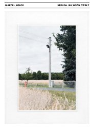
Wrota – Nowy puc: Kreuzung mit<br />
altem Strommast, Weg nach Miłoraz und<br />
Rohner Torhaus<br />
Wrota – Nowy puc: Junction with old<br />
electricity pylon, path to Miłoraz and Rohne<br />
Gatehouse<br />
20121021 42-12-03 N03<br />
Blickrichtung und GPS / Dev<br />
130°<br />
x-Wert 14,55060714<br />
y-Wert 51,50287587<br />
Alltag, Detail, Geschichte, Wald, Wasser,<br />
Weg<br />
Detail, Everyday life, Forest, History, Path,<br />
Water<br />
Notiz / Note<br />
Nowy puc: Flößgraben mit<br />
Löschwasserschild, mündet bei Mułkecy<br />
in die <strong>Struga</strong>, später in die Sprjewja<br />
Nowy puc: Timber rafting channel<br />
with extinguishing water sign, flows into<br />
the <strong>Struga</strong> at Mułkecy<br />
13. Wald i/ Forest i<br />
Trebendorf / Trjebin<br />
13. Wald i/ Forest i<br />
Trebendorf / Trjebin<br />
Blatt-Nr. / Panel no. 635<br />
Blatt-Nr. / Panel no. 636<br />
Negativ-Nr. / Negative no.<br />
Kategorie / Category<br />
Negativ-Nr. / Negative no.<br />
Kategorie / Category<br />
20121021 42-12-03 N05<br />
Blickrichtung und GPS / Dev<br />
Detail, Geschichte, Sorben, Wald, Wasser<br />
Detail, Forest, History, Sorbs, Water<br />
20121021 42-12-03 N06<br />
Blickrichtung und GPS / Dev<br />
Detail, Geschichte, Sorben, Wald, Wasser<br />
Detail, Forest, History, Sorbs, Water<br />
100°<br />
x-Wert 14,55027689<br />
y-Wert 51,50277574<br />
Notiz / Note<br />
Les, hola: Geodätischer Fixpunkt am<br />
Flößgraben, Wasserzulauf der <strong>Struga</strong><br />
Les, hola: Geodetic fixed point on the timber<br />
rafting channel, confluence into the <strong>Struga</strong><br />
110°<br />
x-Wert 14,55043503<br />
y-Wert 51,50280331<br />
Notiz / Note<br />
Les, hola: Stamm der breza am<br />
Flößgraben, Wasserzulauf des Flutgrabens,<br />
der <strong>Struga</strong> und der Spree<br />
Les, hola: Trunk of the breza at the<br />
confluence into the <strong>Struga</strong>