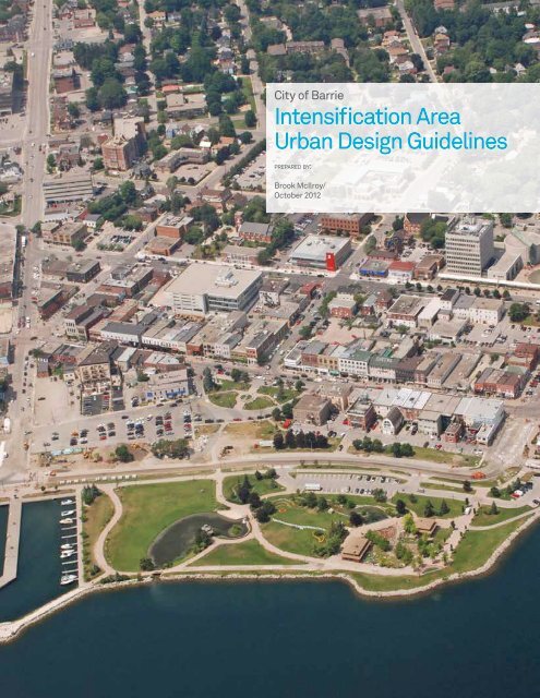
Intensification Area Urban Design Guidelines - City of Barrie
Intensification Area Urban Design Guidelines - City of Barrie
Intensification Area Urban Design Guidelines - City of Barrie

You also want an ePaper? Increase the reach of your titles
YUMPU automatically turns print PDFs into web optimized ePapers that Google loves.
<strong>City</strong> <strong>of</strong> <strong>Barrie</strong><br />
<strong>Intensification</strong> <strong>Area</strong><br />
<strong>Urban</strong> <strong>Design</strong> <strong>Guidelines</strong><br />
prepared by:<br />
Brook McIlroy/<br />
October 2012<br />
DRAFT
DRAFT
Table <strong>of</strong> Contents<br />
i Executive Summary vii<br />
i. Study Overview i<br />
ii. Application <strong>of</strong> the <strong>Guidelines</strong> i<br />
iii. Existing Conditions iii<br />
iv. <strong>Intensification</strong> Vision iii<br />
v. <strong>Intensification</strong> Typologies iii<br />
vi. Mixed-Use and Residential Avenues iv<br />
vii. Mixed-Use Main Streets v<br />
viii. Established Neighbourhood Streets vi<br />
ix. <strong>Intensification</strong> Nodes vii<br />
x. Major Transit Station <strong>Area</strong>s viii<br />
1.0 Introduction x<br />
1.1 Study Overview 1<br />
1.2 Study Process 1<br />
1.2.1 <strong>Intensification</strong> Typologies 2<br />
1.3 Application <strong>of</strong> the <strong>Guidelines</strong> 2<br />
1.4 Document Structure 3<br />
1.5 Existing Planning Framework 4<br />
2.0 Evolution <strong>of</strong> the <strong>Intensification</strong> <strong>Area</strong>s 6<br />
2.1 Introduction 8<br />
2.2 Existing Conditions 9<br />
2.2.1 Auto-Oriented Commercial Districts 11<br />
2.2.2 Corridor Residential Districts 13<br />
2.2.3 Core Districts 15<br />
2.2.4 <strong>City</strong>-Wide Issues 17<br />
2.3 Public and Stakeholder Consultation 18<br />
2.4 Vision and Guiding Principles 19<br />
2.4.1 Vision for the <strong>Intensification</strong> <strong>Area</strong>s 19<br />
2.4.2 Priority Directions 20<br />
2.5 <strong>Intensification</strong> Typologies 21<br />
2.5.1 Mixed-Use and Residential Avenues 23<br />
2.5.2 Mixed-Use Main Streets 25<br />
DRAFT<br />
2.5.3 Established Neighbourhood Streets 27<br />
3.0 Public Realm <strong>Urban</strong> <strong>Design</strong> <strong>Guidelines</strong> 30<br />
3.1 Natural Heritage Feature, Parks and Open Spaces 31<br />
3.1.1 Natural Heritage Features 32<br />
3.1.2 Parks and Open Spaces 33<br />
3.1.3 Semi-Private Open Spaces 34<br />
3.1.4 Multi-Use Trails 35<br />
3.2 Streets and Streetscapes 36<br />
3.2.1 Green Street <strong>Design</strong> 37<br />
3.2.2 Boulevard <strong>Design</strong> 39<br />
3.2.3 Crosswalks 41<br />
3.2.4 Street Furniture 42<br />
3.2.5 Public Art 43<br />
3.2.6 Signage 44<br />
3.2.7 Transit Amenities 45<br />
3.2.8 Lighting 46<br />
3.2.9 Utilities 47<br />
3.3 Parking 48<br />
3.3.1 On-Street Parking 49<br />
3.3.2 Bicycle Parking 50
Table <strong>of</strong> Contents Cont.<br />
4.0 Private Realm <strong>Urban</strong> <strong>Design</strong> <strong>Guidelines</strong> 52<br />
4.1 Development <strong>of</strong> Large Parcels 53<br />
4.1.1 Community Structure 54<br />
4.1.2 Lot Size Variety 56<br />
4.1.3 Transit Supportive <strong>Design</strong> 57<br />
4.2 Access and Parking 58<br />
4.2.1 Surface Parking 59<br />
4.2.2 Structured Parking 61<br />
4.2.3 Lanes and Alleys 63<br />
4.2.4 Servicing and Loading 64<br />
4.3 General Building <strong>Guidelines</strong> 65<br />
4.3.1 Building Orientation and Site Layout 66<br />
4.3.2 Building Heights 67<br />
4.3.3 Minimum Ground Floor Height 68<br />
4.3.4 Front Façade Step-backs 69<br />
4.3.5 Side Building Set-backs 70<br />
4.3.6 Side Building Step-backs 71<br />
4.3.7 Transition to Neighbourhoods 72<br />
4.3.8 Building Articulation 72<br />
4.3.9 Ro<strong>of</strong>s and Ro<strong>of</strong>scapes 74<br />
4.3.10 Materials 75<br />
5.0 <strong>Area</strong>-Specific <strong>Urban</strong> <strong>Design</strong> <strong>Guidelines</strong> 78<br />
5.1 Mixed-Use and Residential Avenue <strong>Guidelines</strong> 79<br />
5.1.1 Prominent Streets 80<br />
5.1.2 Boulevard <strong>Design</strong> 81<br />
5.1.3 Crosswalks 82<br />
5.1.4 Demonstration Plan: Bayfield Street (at Livingstone Street) 83<br />
5.1.5 Demonstration Plan: Bayfield Street (south <strong>of</strong> Highway 400) 85<br />
5.2 Mixed-Use Main Street <strong>Guidelines</strong> 87<br />
5.2.1 Pedestrian-Supportive Uses 88<br />
5.2.2 Parks and Open Spaces 88<br />
5.2.3 Boulevard <strong>Design</strong> 89<br />
5.2.4 Heritage Context Infill 90<br />
5.2.5 Demonstration Plan: Bradford Street (between John Street and Victoria Street) 93<br />
5.3 Established Residential Street <strong>Guidelines</strong> 95<br />
DRAFT<br />
5.3.1 Boulevard <strong>Design</strong> 96<br />
5.3.2 New Residential Buildings 96<br />
5.3.3 Demonstration Plan: Duckworth Street (at Grove Street) 97<br />
5.4 <strong>Intensification</strong> Node <strong>Guidelines</strong> 99<br />
5.5 Gateway <strong>Area</strong> <strong>Guidelines</strong> 101<br />
5.6 Major Transit Station <strong>Area</strong> <strong>Guidelines</strong> 103<br />
5.7 Historic Allandale Neighbourhood <strong>Guidelines</strong> 107<br />
5.8 Lakeshore Drive 109<br />
6.0 Implementation Recommendations 112<br />
6.1 Overview 113<br />
6.1.1 Policy and Zoning Amendments 114<br />
6.1.2 Education Programs 118<br />
6.1.3 Implementation, Monitoring and Updating Processes 118
List <strong>of</strong> Figures<br />
Figure 1: <strong>Intensification</strong> Typologies ii<br />
Figure 2: Mixed-Use and Residential Avenue Rendering iv<br />
Figure 3: Mixed-Use Main Street Rendering v<br />
Figure 4: Established Neighbourhood Streets Rendering vi<br />
Figure 5: <strong>Intensification</strong> Nodes Rendering vii<br />
Figure 6: Major Transit Station <strong>Area</strong> Rendering viii<br />
Figure 7: Schedule I: <strong>Intensification</strong> <strong>Area</strong>s 7<br />
Figure 8: Existing typologies within<br />
the <strong>Intensification</strong> <strong>Area</strong>s 10<br />
Figure 9: Existing Auto-Oriented<br />
Commercial Districts within the <strong>Intensification</strong> <strong>Area</strong>s 12<br />
Figure 10: Existing Corridor Residential<br />
Districts within the <strong>Intensification</strong> <strong>Area</strong>s 14<br />
Figure 11: Existing Core Districts within<br />
the <strong>Intensification</strong> <strong>Area</strong>s 16<br />
Figure 12: <strong>Barrie</strong> Transit Network 17<br />
Figure 13: Large-Format Retail (Surface Parking <strong>Area</strong>s) 17<br />
Figure 14: <strong>Intensification</strong> Typologies 22<br />
Figure 15: <strong>Intensification</strong> Typologies<br />
(Mixed-Use and Residential Avenues) 24<br />
Figure 16: <strong>Intensification</strong> Typologies (Mixed-Use<br />
Main Streets) 26<br />
Figure 17: <strong>Intensification</strong> Typologies (Established<br />
Residential Streets) 28<br />
Figure 18: Neighbourhood Park Demonstration Site 33<br />
Figure 19: Green Street Rendering 37<br />
Figure 20: Boulevard Components 39<br />
Figure 21: Boulevard Rendering 40<br />
Figure 22: Mid-Block Connections 54<br />
Figure 23: Street Network Structure 55<br />
Figure 24: Lot Size Variety 56<br />
Figure 25: Parking Courts 60<br />
Figure 26: Evolution <strong>of</strong> Structured Parking 62<br />
Figure 27: Rear Transition to Neighbourhoods 63<br />
Figure 28: Mechanical Penthouse Placement 63<br />
Figure 29: Building Location at Street Edge 66<br />
Figure 30: Maximum Building Heights 67<br />
Figure 31: Maximum Ground Floor Height 68<br />
Appendices<br />
Appendix A: Existing Policy Framework<br />
Appendix B: <strong>Urban</strong> <strong>Design</strong> Glossary<br />
Appendix C: <strong>Urban</strong> <strong>Design</strong> <strong>Guidelines</strong> Checklist<br />
Figure 32: Front Façade Step-backs 69<br />
Figure 33: Side Building Step-backs 70<br />
Figure 34: Side Building Step-backs 71<br />
Figure 35: Tall Street Wall 71<br />
Figure 36: Porous Street Wall 71<br />
Figure 37: Transition to Neighbourhoods 72<br />
Figure 38: Sample Building Articulation 73<br />
Figure 39: Mechanical Penthouse Placement 74<br />
Figure 40: Mixed-Use and Residential<br />
Avenue Rendering 79<br />
Figure 41: Prominent Street Rendering 80<br />
Figure 42: Boulevard Widths 81<br />
Figure 43: Bayfield Street (at Livingstone Street)<br />
Demonstration Plan - Axonometric View 83<br />
Figure 44: Bayfield Street (at Livingstone Street)<br />
Demonstration Plan - Plan View 84<br />
Figure 45: Bayfield Street (South <strong>of</strong> Highway 400)<br />
Demonstration Plan - Axonometric View 85<br />
Figure 46: Bayfield Street (South <strong>of</strong> Highway 400)<br />
Demonstration Plan - Plan View 86<br />
Figure 47: Mixed-Use Main Street Rendering 87<br />
Figure 48: Parks and Open Space Demonstration Site 88<br />
Figure 49: Heritage Infill Set-back 90<br />
Figure 50: Heritage Streetwall 91<br />
Figure 51: Bradford Street Demonstration<br />
Plan - Axonometric View 93<br />
Figure 52: Bradford Street Demonstration<br />
Plan - Plan View 94<br />
Figure 53: Established Residential Street Rendering 95<br />
Figure 54: Duckworth Street Demonstration<br />
Plan - Axonometric View 97<br />
Figure 55: Duckworth Street Demonstration<br />
Plan - Plan View 98<br />
Figure 56: <strong>Intensification</strong> Nodes Rendering 99<br />
Figure 57: <strong>City</strong> Gateway Rendering 101<br />
Figure 58: Major Transit Station <strong>Area</strong> Rendering 103<br />
Figure 59: Sample Station <strong>Area</strong> Rendering 1 105<br />
Figure 60: Sample Station <strong>Area</strong> Rendering 2 106<br />
DRAFT
DRAFT
DRAFT<br />
vii<br />
i<br />
Executive Summary<br />
The <strong>City</strong> <strong>of</strong> <strong>Barrie</strong> <strong>Intensification</strong> <strong>Area</strong> <strong>Urban</strong> <strong>Design</strong> <strong>Guidelines</strong> provide a vision, a<br />
set <strong>of</strong> priority directions, and detailed design guidelines, to direct new development<br />
within the <strong>Intensification</strong> Nodes and Corridors, <strong>Urban</strong> Growth Centre, and Major<br />
Transit Station <strong>Area</strong>s identified in the <strong>City</strong> <strong>of</strong> <strong>Barrie</strong> Official Plan.
i <strong>Urban</strong> <strong>Design</strong> <strong>Guidelines</strong> for <strong>Barrie</strong>’s <strong>Intensification</strong> <strong>Area</strong>s - DRAFT<br />
i. Study Overview<br />
These urban design guidelines direct new development<br />
within the <strong>Intensification</strong> Nodes and Corridors, <strong>Urban</strong> Growth<br />
Centre, and Major Transit Station <strong>Area</strong>s identified in the <strong>City</strong><br />
<strong>of</strong> <strong>Barrie</strong> Official Plan. The guidelines present a vision, and a<br />
set <strong>of</strong> priority directions, to ensure that new development is<br />
compatible with the existing built fabric, creates an attractive<br />
and safe pedestrian realm, supports alternative modes<br />
<strong>of</strong> transportation (i.e. walking, cycling and transit), and is<br />
environmentally sustainable.<br />
To implement the recommendations <strong>of</strong> these guidelines,<br />
policy and zoning amendments will be required, including:<br />
• As-<strong>of</strong>-Right Zoning;<br />
• Set Maximum Allowable Heights at 8-Storeys;<br />
• Increase Allowable Heights at Key Opportunity Sites;<br />
• Require a Minimum Building Height <strong>of</strong> 2 to 3-Storeys;<br />
• Incorporate Built Form Criteria to Regulate Building Mass;<br />
• Require a Minimum Ground Floor Height <strong>of</strong> 4.5 Metres and<br />
Active Ground Floor Uses in the <strong>Intensification</strong> <strong>Area</strong>s;<br />
• Secure a Minimum Building Set-back to Ensure a 4.8<br />
metre Boulevard; and,<br />
• Prohibit Drive-Through Uses within the <strong>Urban</strong> Growth<br />
Centre.<br />
In addition, tools provided through the Planning Act should be<br />
applied, including:<br />
• Establishing Minimum and Maximum Standards in the<br />
Zoning By-Law;<br />
• Height and Density Bonusing;<br />
• Cash in Lieu <strong>of</strong> Parking;<br />
• Cash in Lieu <strong>of</strong> Parkland;<br />
• Site Plan Controls (with exterior design controls or not);<br />
• Development Permit System; and,<br />
• Community Improvement Plans.<br />
ii. Application <strong>of</strong> the<br />
<strong>Guidelines</strong><br />
This document is intended to assist <strong>City</strong> Planning Staff, land<br />
owners, developers and the public with clear tools to guide<br />
intensification on private land, as well as public infrastructure,<br />
such as utilities, pump houses, hydro substations, fire halls,<br />
arenas, and other public buildings and structures.<br />
The guidelines apply to development applications that are<br />
submitted following the adoption <strong>of</strong> the guidelines. Where<br />
applications are in process at the time the guidelines are<br />
adopted, the <strong>City</strong> should work with the developer to determine<br />
if the directions <strong>of</strong> the guidelines can be met.<br />
Those using the guidelines should locate their site within the<br />
<strong>Intensification</strong> Typologies outlined on the following page, and<br />
refer to the respective section <strong>of</strong> the document. In addition,<br />
general Public Realm <strong>Urban</strong> <strong>Design</strong> <strong>Guidelines</strong> and Private<br />
Realm <strong>Urban</strong> <strong>Design</strong> <strong>Guidelines</strong> are provided. These guidelines<br />
apply to all projects within the <strong>Intensification</strong> <strong>Area</strong>s.<br />
Developments within the <strong>Intensification</strong> Nodes are guided by<br />
the <strong>Intensification</strong> Typology in which they are located, as well<br />
as the additional guidelines provided in Section 5.4.<br />
It is the responsibility <strong>of</strong> the user to reference all sections that<br />
are relevant to their application.<br />
DRAFT
Miller Dr.<br />
Livingstone St. W.<br />
Figure 1: <strong>Intensification</strong> Typologies<br />
Cundles Rd. W.<br />
DUNLOP STREET<br />
Anne St. S.<br />
ESSA ROAD<br />
BAYFIELD STREET<br />
DUCKWORTH STREET<br />
Grove St. E.<br />
KEMPENFELT BAY<br />
Little Ave.<br />
YONGE STREET<br />
DRAFT<br />
Big Bay Point Rd.<br />
Mapleview Dr. E.<br />
Mixed-Use & Residential Avenues<br />
Mixed-Use Main Streets<br />
Established Residential Streets<br />
Lakeshore Drive & Waterfront<br />
Allandale Neighbourhood<br />
Primary Node<br />
Secondary Node<br />
Major Transit Station<br />
0m 500m 1km<br />
2km<br />
ii
iii <strong>Urban</strong> <strong>Design</strong> <strong>Guidelines</strong> for <strong>Barrie</strong>’s <strong>Intensification</strong> <strong>Area</strong>s - DRAFT<br />
iii. Existing Conditions<br />
Three common types <strong>of</strong> development exist within the<br />
<strong>Intensification</strong> <strong>Area</strong>s, including:<br />
• Auto-Oriented Commercial Districts, including Bayfield<br />
Street (north <strong>of</strong> Highway 400), Dunlop Street (at Miller<br />
Drive), Essa Road (at Mapleview Drive), and Yonge Street<br />
(at Little Avenue).<br />
• Core Districts, including Collier Street, and Dunlop Street<br />
East.<br />
• Corridor Residential Districts, including Duckworth Street<br />
(south <strong>of</strong> Grove Street), Essa Road, and Dunlop Street<br />
(east <strong>of</strong> Anne Street).<br />
iv. <strong>Intensification</strong> Vision<br />
Building on the <strong>City</strong> <strong>of</strong> <strong>Barrie</strong> <strong>Intensification</strong> Strategy (2009),<br />
and in consultation with the community, the following<br />
describes the vision/goal for the <strong>Intensification</strong> <strong>Area</strong>s:<br />
“New development and revitalization within the <strong>Intensification</strong><br />
<strong>Area</strong>s will result in active, pedestrian-supportive streets that are<br />
compatible with, and enhance, adjacent land uses. Mixed-Use and<br />
Residential Avenues, Mixed-Use Main Streets and Established<br />
Neighbourhood Streets will be characterized by wide boulevards,<br />
abundant landscaping, large, mature street trees, public art, and<br />
active at-grade uses.”<br />
v. <strong>Intensification</strong><br />
Typologies<br />
As intensification occurs, these Auto-Oriented Commercial<br />
Districts, Core Districts, and Corridor Residential Districts<br />
should evolve to reflect higher density, more urban conditions,<br />
defined as:<br />
• Mixed-Use and Residential Avenues<br />
• Mixed-Use Main Streets<br />
DRAFT<br />
• Established Neighbourhood Streets<br />
Together, these typologies comprise the <strong>Intensification</strong> Nodes<br />
and Corridors, the <strong>Urban</strong> Growth Centre, and the Major Transit<br />
Station <strong>Area</strong>s as identified in the <strong>City</strong> <strong>of</strong> <strong>Barrie</strong> Official Plan.
vi. Mixed-Use and<br />
Residential Avenues<br />
The majority <strong>of</strong> the <strong>Intensification</strong> Corridors (and the Primary<br />
and Secondary <strong>Intensification</strong> Nodes located along them)<br />
should evolve into Mixed-Use and Residential Avenues,<br />
including Duckworth Street (north <strong>of</strong> Grove Street), Bayfield<br />
Street, Dunlop Street, Essa Road, and Yonge Street. Please<br />
refer to the Demonstration Sites on page 84 and 86.<br />
Key opportunities include:<br />
• Redevelopment <strong>of</strong> underutilized parcels for streetoriented<br />
mixed-use development in low to mid-rise<br />
buildings.<br />
• Subdivision <strong>of</strong> large blocks into smaller, walkable blocks<br />
through walkways, drive-aisles, and where feasible, new<br />
roads.<br />
• Opportunities to redefine the existing street and boulevard<br />
within the right-<strong>of</strong>-way.<br />
Key recommendations include:<br />
• In the short-term, redevelopment should be focused at<br />
the <strong>Intensification</strong> Nodes.<br />
• Ultimately, the <strong>Intensification</strong> Corridors should transition<br />
to major transportation streets, balancing functional<br />
requirements with the provision <strong>of</strong> an active, pedestriansupportive<br />
streetscape.<br />
• Human-scaled, mixed-use buildings should line the street,<br />
providing “eyes on the street,” and enhancing safety and<br />
activity at all hours.<br />
• Wide boulevards should accommodate street trees,<br />
landscaping, continuous sidewalks, seating, signage and<br />
public art.<br />
• Spill-out retail uses at grade (i.e. restaurants, cafes), and<br />
open spaces (i.e. small parks/plazas on infill sites, or<br />
within the building set-back), will <strong>of</strong>fer opportunities for<br />
pedestrians to gather and socialize.<br />
DRAFT<br />
Figure 2: Mixed-Use and Residential Avenue Rendering<br />
The Mixed-Use and Residential Avenues should evolve into street-oriented, mixed-use development at a low to mid-rise scale.<br />
iv
v <strong>Urban</strong> <strong>Design</strong> <strong>Guidelines</strong> for <strong>Barrie</strong>’s <strong>Intensification</strong> <strong>Area</strong>s - DRAFT<br />
vii. Mixed-Use Main<br />
Streets<br />
Generally, streets within the <strong>Urban</strong> Growth Centre (with the<br />
exception <strong>of</strong> the Historic Allandale Neighbourhood) should<br />
evolve into Mixed-Use Main Streets, including Dunlop Street,<br />
Bradford Street, Toronto Street, Collier Street, etc. Please<br />
refer to the Demonstration Sites on page 94.<br />
Key opportunities include:<br />
• Additions and renovations to existing buildings.<br />
• Redevelopment <strong>of</strong> vacant or underutilized sites (i.e.<br />
single-storey buildings).<br />
• Development <strong>of</strong> vacant parcels.<br />
Key Recommendations include:<br />
• <strong>Intensification</strong> should be compatible with the existing<br />
heritage fabric (i.e. Dunlop Street) with respect to building<br />
height, scale, façade design and key architectural<br />
characteristics.<br />
• Mixed-Use Main Streets should maintain a tight-knit grid<br />
<strong>of</strong> streets and blocks, and a consistent streetwall height<br />
that reflects the scale and heritage character <strong>of</strong> the<br />
Downtown<br />
• Mixed-use buildings, with retail at grade and residential<br />
and <strong>of</strong>fice above, will allow residents to live, work and<br />
recreate within the <strong>Urban</strong> Growth Centre, creating “eyes<br />
on the street,” and enhancing safety and activity at all<br />
hours.<br />
• Wide boulevards should accommodate street trees,<br />
landscaping, continuous sidewalks, seating, signage and<br />
public art.<br />
• New civic open spaces (where possible), and<br />
enhancements to existing open spaces, are encouraged<br />
to provide opportunities for pedestrian to gather and<br />
socialize.<br />
DRAFT<br />
Figure 3: Mixed-Use Main Street Rendering<br />
Mixed-use Main Streets should encourage human-scaled, mixed-use buildings that are compatible with adjacent existing buildings.
viii. Established<br />
Neighbourhood Streets<br />
Portions <strong>of</strong> the <strong>Intensification</strong> Corridors, including Duckworth<br />
Street (south <strong>of</strong> Grove Street) and Dunlop Street (east <strong>of</strong><br />
Anne Street), are currently well established residential<br />
neighbourhoods. With the exception <strong>of</strong> the conversion <strong>of</strong><br />
dwellings, there is limited potential for intensification on<br />
Established Neighbourhood Streets. Please refer to the<br />
Demonstration Sites on page 96.<br />
Key opportunities include:<br />
• On larger-scale sites, opportunities may exist for the<br />
incorporation <strong>of</strong> higher density residential buildings in<br />
low to mid-rise building forms (i.e. townhouses and walkup<br />
apartments), and potentially mixed-use buildings with<br />
convenience retail at grade.<br />
• The creation <strong>of</strong> walkable, complete neighbourhoods<br />
through intensification that can support associated retail<br />
and community uses.<br />
Key recommendations include:<br />
• As intensification occurs, these areas should incorporate<br />
buildings that are compatible with, and transition to,<br />
adjacent stable residential neighbourhhoods.<br />
• Building heights that ensure compatible built form<br />
transitions to adjacent neighbourhoods.<br />
DRAFT<br />
Figure 4: Established Neighbourhood Streets Rendering<br />
Where opportunities for intensification exist on Established Residential Streets, higher-density housing forms (i.e. townhouses and walk-up apartments)<br />
are encouraged with appropriate transitions to adjacent residential neighbourhoods.<br />
vi
vii <strong>Urban</strong> <strong>Design</strong> <strong>Guidelines</strong> for <strong>Barrie</strong>’s <strong>Intensification</strong> <strong>Area</strong>s - DRAFT<br />
ix. <strong>Intensification</strong> Nodes<br />
Within the <strong>Intensification</strong> Corridors are a series <strong>of</strong> Primary and<br />
Secondary <strong>Intensification</strong> Nodes located at the intersection<br />
<strong>of</strong> major transportation corridors, including:<br />
Primary Nodes - Dunlop Street (at Anne Street), Yonge Street<br />
(at Little Avenue, Big Bay Point Road and Mapleview Drive),<br />
and Duckworth Street (at Grove Street).<br />
Secondary Nodes - Bayfield Street (at Grove Street, Cundles<br />
Road, and Livingstone Street), and Dunlop Street (at Miller<br />
Drive).<br />
Key opportunities include:<br />
• The creation <strong>of</strong> key destinations along the <strong>Intensification</strong><br />
Corridors.<br />
• Promoting arrival into the <strong>City</strong> <strong>of</strong> <strong>Barrie</strong> through<br />
appropriate gateway design.<br />
• Linking the key destinations within the <strong>City</strong> <strong>of</strong> <strong>Barrie</strong>,<br />
including the <strong>Intensification</strong> Nodes, the <strong>Urban</strong> Growth<br />
Centre, and the lakefront.<br />
Key recommendations include:<br />
• Focus the short-term redevelopment <strong>of</strong> the <strong>Intensification</strong><br />
Corridors on the <strong>Intensification</strong> Nodes to spur development<br />
on the remainder <strong>of</strong> the corridor.<br />
• Create attractive gateways, characterized by landmark<br />
buildings, and wide pedestrian-supportive boulevards,<br />
signifying arrival to the <strong>City</strong> <strong>of</strong> <strong>Barrie</strong>.<br />
• Locate the highest densities along the <strong>Intensification</strong><br />
Corridors, through a mix <strong>of</strong> land uses.<br />
• Where appropriate, encourage taller buildings (at a 1:1<br />
ratio with the right-<strong>of</strong>-way width) at <strong>Intensification</strong> Nodes<br />
to indicate the prominence <strong>of</strong> these sites.<br />
• Support <strong>Intensification</strong> Nodes as centres <strong>of</strong> information,<br />
including wayfinding signage that promotes key locations<br />
throughout the <strong>City</strong> (i.e. the <strong>Urban</strong> Growth Centre, the<br />
waterfront, and key parks and open spaces), temporary<br />
advertising (i.e. banners) for <strong>City</strong> events, etc.<br />
DRAFT<br />
Figure 5: <strong>Intensification</strong> Nodes Rendering<br />
At the <strong>Intensification</strong> Nodes, new development should follow the recommendations <strong>of</strong> their respective <strong>Intensification</strong> Typologies, with taller, landmark<br />
buildings at the corners.
x. Major Transit Station<br />
<strong>Area</strong>s<br />
Within the <strong>City</strong> <strong>of</strong> <strong>Barrie</strong>, there are three Major Transit Station<br />
<strong>Area</strong>s, including one on an <strong>Intensification</strong> Corridor (South<br />
<strong>Barrie</strong> GO Station) and two within the <strong>Urban</strong> Growth Centre<br />
(the Downtown Transit Terminal, and the Allandale Waterfront<br />
GO Station).<br />
Key opportunities include:<br />
• Increased densities concentrated within a ten-minute<br />
(500 metre) walking distance <strong>of</strong> Major Transit Station<br />
<strong>Area</strong>s will help to support a viable transit network, and<br />
promote walking, cycling and transit.<br />
Key recommendations include:<br />
• As intensification occurs at or around the Major Transit<br />
Station <strong>Area</strong>s, they should generally evolve to reflect a<br />
Mixed-Use and Residential Avenue, or a Mixed-Use Main<br />
Street, depending on the <strong>Intensification</strong> Typology in which<br />
they are located.<br />
• A mix <strong>of</strong> residential, employment and retail uses are<br />
encouraged near the station rather than dispersed,<br />
segregated uses.<br />
• Auto dependent uses should be discouraged within Major<br />
Transit Station <strong>Area</strong>s, such as drive through retail and car<br />
wash facilities.<br />
• Bus shelters, sidewalk canopies and bicycle parking is<br />
particularly important at Major Transit Station <strong>Area</strong>s to<br />
support active transportation.<br />
• Transit facilities should be located at public places such<br />
as community centres, parks and public open spaces,<br />
schools, and community facilities such as a library or<br />
gallery.<br />
• Trails and bicycle routes should link to transit facilities.<br />
Secure bicycle parking and storage space should also be<br />
provided where appropriate.<br />
DRAFT<br />
Figure 6: Major Transit Station <strong>Area</strong> Rendering<br />
At Major Transit Station <strong>Area</strong>s, new development should follow the recommendations <strong>of</strong> their respective <strong>Intensification</strong> Typologies, with transit amenities<br />
integrated into a well established urban fabric.<br />
viii
DRAFT
DRAFT<br />
1.0<br />
Introduction<br />
The <strong>City</strong> <strong>of</strong> <strong>Barrie</strong> <strong>Intensification</strong> <strong>Area</strong> <strong>Urban</strong> <strong>Design</strong> <strong>Guidelines</strong> will ensure that new<br />
development is compatible with the existing built fabric, creates an attractive and safe<br />
pedestrian realm, supports alternative modes <strong>of</strong> transportation, and is environmentally<br />
sustainable.
1 <strong>Urban</strong> <strong>Design</strong> <strong>Guidelines</strong> for <strong>Barrie</strong>’s <strong>Intensification</strong> <strong>Area</strong>s - DRAFT<br />
1.1 Study Overview<br />
Places to Grow: The Growth Plan for the Greater Golden<br />
Horseshoe (2006) directs all new growth in the Province to<br />
key <strong>Intensification</strong> <strong>Area</strong>s, including <strong>Intensification</strong> Corridors,<br />
<strong>Urban</strong> Growth Centres, and Major Transit Station <strong>Area</strong>s. The<br />
<strong>City</strong> <strong>of</strong> <strong>Barrie</strong> and Brook McIlroy have prepared these urban<br />
design guidelines to help direct new development within the<br />
<strong>Intensification</strong> <strong>Area</strong>s identified in the <strong>City</strong> <strong>of</strong> <strong>Barrie</strong> Official<br />
Plan. The guidelines present a vision for the <strong>Intensification</strong><br />
<strong>Area</strong>s, and a set <strong>of</strong> priority directions, to ensure that new<br />
development is compatible with the existing built fabric,<br />
creates an attractive and safe pedestrian realm, supports<br />
alternative modes <strong>of</strong> transportation (i.e. walking, cycling and<br />
transit), and is environmentally sustainable.<br />
This initiative is an important step towards achieving the<br />
Province and the <strong>City</strong>’s long-term vision for high quality growth.<br />
To implement the recommendations <strong>of</strong> these guidelines,<br />
policy and zoning amendments will be required, and tools<br />
provided through the Planning Act should be applied (please<br />
refer to Section 6).<br />
1.2 Study Process<br />
Recognizing the common characteristics between the<br />
<strong>Intensification</strong> <strong>Area</strong>s, a typology was developed to distinguish<br />
between the three predominant types <strong>of</strong> built form, including:<br />
• Auto-Oriented Commercial Districts, such as Bayfield<br />
Street (north <strong>of</strong> Highway 400), Dunlop Street (at Miller<br />
Drive), Essa Road (at Mapleview Drive), and Yonge Street<br />
(at Little Avenue).<br />
• Core Districts, such as Collier Street, and Dunlop Street<br />
East).<br />
• Corridor Residential Districts, such as Duckworth Street<br />
(south <strong>of</strong> Grove Street), Essa Road, and Dunlop Street<br />
(east <strong>of</strong> Anne Street).<br />
Please refer to Section 2.2 for a detailed description <strong>of</strong> the existing<br />
conditions that define each <strong>of</strong> these typologies.<br />
DRAFT
1.2.1 <strong>Intensification</strong> Typologies<br />
Each <strong>of</strong> these <strong>Intensification</strong> <strong>Area</strong>s was examined in<br />
detail, through site visits and consultation with the <strong>City</strong>,<br />
local stakeholders, and the community, to examine their<br />
characteristics and role in the urban structure and to<br />
identify opportunities for intensification and urbanization.<br />
As intensification occurs, the Auto-Oriented Commercial<br />
Districts, Core Districts, and Corridor Residential Districts<br />
should evolve into more pedestrian-supportive streets and<br />
blocks, described throughout this document as:<br />
• Mixed-Use and Residential Avenues, including Bayfield<br />
Street, Dunlop Street, Essa Road, and Yonge Street.<br />
• Mixed-Use Main Streets, including streets within the<br />
<strong>Urban</strong> Growth Centre.<br />
• Established Residential Streets, including Duckworth<br />
Street, Dunlop Street (east <strong>of</strong> Highway 400), and the<br />
historic Allandale neighbourhood.<br />
Together, these typologies comprise the <strong>Intensification</strong> Nodes<br />
and Corridors, the <strong>Urban</strong> Growth Centre, and the Major Transit<br />
Station <strong>Area</strong>s as identified in the <strong>City</strong> <strong>of</strong> <strong>Barrie</strong> Official Plan.<br />
Demonstration sites were prepared based on best practices<br />
to show how intensification could occur on existing sites in<br />
each <strong>of</strong> these typologies.<br />
1.3 Application <strong>of</strong> the<br />
<strong>Guidelines</strong><br />
The recommendations <strong>of</strong> this study apply to the <strong>Intensification</strong><br />
<strong>Area</strong>s outlined in the <strong>City</strong> <strong>of</strong> <strong>Barrie</strong> Official Plan, including the<br />
<strong>Urban</strong> Growth Centre, <strong>Intensification</strong> Corridors, and Major<br />
Transit Stations <strong>Area</strong>s. The document is intended to assist<br />
<strong>City</strong> Planning Staff, land owners, developers and the public<br />
with clear tools to guide intensification on private land, as well<br />
as public infrastructure, such as utilities, pump houses, hydro<br />
substations, fire halls, arenas, and other public buildings and<br />
structures.<br />
The guidelines apply to development applications that are<br />
submitted following the adoption <strong>of</strong> the guidelines. Where<br />
applications are in process at the time the guidelines are<br />
adopted, the <strong>City</strong> should work with the developer to determine<br />
if the directions <strong>of</strong> the guidelines can be met.<br />
Those using the guidelines should locate their site within the<br />
<strong>Intensification</strong> Typologies outlined on Page 22, and refer to<br />
the respective section <strong>of</strong> the document. In addition, general<br />
Public Realm <strong>Urban</strong> <strong>Design</strong> <strong>Guidelines</strong> and Private Realm<br />
<strong>Urban</strong> <strong>Design</strong> <strong>Guidelines</strong> are provided. These guidelines<br />
apply to all projects within the <strong>Intensification</strong> <strong>Area</strong>s.<br />
Developments within the <strong>Intensification</strong> Nodes are guided by<br />
the <strong>Intensification</strong> Typology in which they are located, as well<br />
as the additional guidelines provided in Section 5.4.<br />
DRAFT<br />
Users should reference all sections that are relevant to their<br />
application.<br />
2
3 <strong>Urban</strong> <strong>Design</strong> <strong>Guidelines</strong> for <strong>Barrie</strong>’s <strong>Intensification</strong> <strong>Area</strong>s - DRAFT<br />
The guidelines outlined in this document may be implemented<br />
through future revisions to the <strong>City</strong> <strong>of</strong> <strong>Barrie</strong> Official Plan<br />
and Zoning By-laws, as well as action items, that can be<br />
implemented pending further study.<br />
The design guidelines should not be so prescriptive as<br />
to preclude excellent design and development options<br />
consistent with the directions <strong>of</strong> the guidelines. As the<br />
recommendations become common practice, they should<br />
evolve. It is recommended that the guidelines be reviewed,<br />
and amended as necessary, every five years.<br />
The illustrative examples shown throughout the document<br />
demonstrate one example <strong>of</strong> how the guidelines can be<br />
applied, and are not intended to exclude other standards that<br />
meet the intent <strong>of</strong> the guidelines.<br />
1.4 Document Structure<br />
The <strong>City</strong> <strong>of</strong> <strong>Barrie</strong> <strong>Intensification</strong> <strong>Area</strong> <strong>Urban</strong> <strong>Design</strong><br />
<strong>Guidelines</strong> are divided into six sections.<br />
Section One: Introduction – Provides an introduction to<br />
the design guidelines, including an overview <strong>of</strong> the study<br />
and process, and the application <strong>of</strong> the guidelines. Also<br />
includes a brief summary <strong>of</strong> the existing planning framework<br />
and supporting documents that govern development and<br />
intensification within the Province and the <strong>City</strong> (i.e. the<br />
Planning Act, the Growth Plan, the <strong>City</strong> <strong>of</strong> <strong>Barrie</strong> Official Plan).<br />
Section Two: Evolution <strong>of</strong> the <strong>Intensification</strong> <strong>Area</strong>s –<br />
Describes the evolution <strong>of</strong> the <strong>Intensification</strong> <strong>Area</strong>s, including<br />
a brief description <strong>of</strong> the existing conditions, including<br />
their general characteristics and key issues; the priority<br />
directions from the community consultation; and, the vision<br />
for the <strong>Intensification</strong> <strong>Area</strong>s, including the key intensification<br />
typologies.<br />
DRAFT
Section Three: Public Realm <strong>Urban</strong> <strong>Design</strong> <strong>Guidelines</strong> –<br />
Provides design guidelines that are applicable to development<br />
within the public realm, including natural heritage features,<br />
parks and open spaces, streets and streetscapes, pedestrian<br />
and bicycle circulation, and parking.<br />
Section Four: Private Realm <strong>Urban</strong> <strong>Design</strong> <strong>Guidelines</strong> –<br />
Provides guidelines that are applicable to development within<br />
the private realm, including the development <strong>of</strong> large parcels,<br />
access and parking, and general building guidelines.<br />
Section Five: <strong>Area</strong> Specific <strong>Urban</strong> <strong>Design</strong> <strong>Guidelines</strong> –<br />
Provides guidelines that are specific to the intensification<br />
typologies, as well as other unique areas, including Major<br />
Transit Station <strong>Area</strong>s, the historic Allandale Neighbourhood,<br />
and Lakeshore Drive.<br />
Section Six: Implementation Recommendations – Provides<br />
recommendations for a variety <strong>of</strong> implementation strategies<br />
to assist in the adoption <strong>of</strong> these guidelines.<br />
1.5 Existing Planning<br />
Framework<br />
The planning framework that guides development and<br />
intensification within the <strong>City</strong> <strong>of</strong> <strong>Barrie</strong> and the <strong>Intensification</strong><br />
<strong>Area</strong>s consists <strong>of</strong> policy documents and supporting<br />
guiding documents. Broadly, this framework encourages<br />
intensification within the <strong>Intensification</strong> <strong>Area</strong>s, providing it<br />
is compatible with existing development. The documents<br />
reviewed as part <strong>of</strong> this study include:<br />
Policy Documents:<br />
• Provincial Policy Statement (2005)<br />
• Places to Grow: Growth Plan for the Greater Golden<br />
Horseshoe (2006)<br />
• Lake Simcoe Protection Plan (2009)<br />
• The <strong>City</strong> <strong>of</strong> <strong>Barrie</strong> Official Plan (2009)<br />
• <strong>City</strong> <strong>of</strong> <strong>Barrie</strong> Comprehensive Zoning Bylaw (2009)<br />
Supporting Documents:<br />
• Downtown <strong>Barrie</strong>: The Next Wave (2004)<br />
• <strong>City</strong> <strong>of</strong> <strong>Barrie</strong> Downtown Commercial Master Plan (2006)<br />
• <strong>City</strong> <strong>of</strong> <strong>Barrie</strong> <strong>Intensification</strong> Study (2009)<br />
• Historic Neighbourhoods Strategy (2010)<br />
Please refer to the appendix for a detailed summary <strong>of</strong> the<br />
above-mentioned documents, including their relationship to<br />
the <strong>Intensification</strong> <strong>Area</strong>s, and their general recommendations<br />
regarding intensification.<br />
DRAFT<br />
4
DRAFT
2.0<br />
Evolution <strong>of</strong> the<br />
<strong>Intensification</strong> <strong>Area</strong>s<br />
DRAFT<br />
A variety <strong>of</strong> typologies exist within the <strong>Intensification</strong> <strong>Area</strong>s, including Auto-Oriented<br />
Commercial Districts, Corridor Residential Districts, and Core Districts. Through<br />
intensification, these areas will evolve into active, pedestrian-supportive Mixed-Use<br />
and Residential Avenues, Mixed-Use Main Streets and Established Residential Streets.
7 <strong>Urban</strong> <strong>Design</strong> <strong>Guidelines</strong> for <strong>Barrie</strong>’s <strong>Intensification</strong> <strong>Area</strong>s - DRAFT<br />
Figure 7: Schedule I: <strong>Intensification</strong> <strong>Area</strong>s<br />
Source: <strong>City</strong> <strong>of</strong> <strong>Barrie</strong> Official Plan (April, 2010)<br />
DRAFT<br />
Note: This Major Transit<br />
Node does not include<br />
lands within the “Annexed<br />
area” south <strong>of</strong> Mapleview<br />
Drive.
2.1 Introduction<br />
The <strong>City</strong> <strong>of</strong> <strong>Barrie</strong> Official Plan identifies key <strong>Intensification</strong><br />
<strong>Area</strong>s, including:<br />
• The <strong>Urban</strong> Growth Centre – Generally bounded by Berczy<br />
Street and Kempenfelt Bay in the east, Codrington Street<br />
and Sophia Street to the north, Bradford Street to the<br />
west, and Burton Avenue to the south.<br />
• Major Transit Station <strong>Area</strong>s – Includes the South <strong>Barrie</strong> GO<br />
Station, the Downtown Transit Terminal, and the Allandale<br />
Waterfront GO Station.<br />
• <strong>Intensification</strong> Corridors – Includes Duckworth Street,<br />
Bayfield Street, Dunlop Street, Essa Road and Yonge<br />
Street. Key intersecting streets within these corridors<br />
are classified as Primary and Secondary <strong>Intensification</strong><br />
Nodes.<br />
Within these <strong>Intensification</strong> <strong>Area</strong>s, a variety <strong>of</strong> conditions<br />
exist. For instance, the main street character <strong>of</strong> Collier<br />
Street and Dunlop Street in the <strong>Urban</strong> Growth Centre differs<br />
significantly from the large format retail uses on Bayfield<br />
Street, and again from the existing stable residential uses on<br />
Duckworth Street. However, there are a number <strong>of</strong> conditions<br />
that occur regularly throughout the <strong>Intensification</strong> <strong>Area</strong>s. The<br />
following typologies outline the three predominant types <strong>of</strong><br />
development within the <strong>Intensification</strong> <strong>Area</strong>s (please refer to<br />
the Map on Page 10):<br />
• Auto-Oriented Commercial Districts, such as Bayfield<br />
Street (north <strong>of</strong> Highway 400, including the Secondary<br />
Nodes at Cundles Road and Livingstone Street), Dunlop<br />
Street (at and between the Secondary Node at Miller<br />
Drive and the Primary Node at Anne Street), Essa Road<br />
(at Mapleview Drive), Yonge Street (including the Primary<br />
Nodes at Little Avenue and Big Bay Point Road), and the<br />
Primary Node at Duckworth Street and Grove Street.<br />
• Core Districts, such as Collier Street, Dunlop Street East,<br />
and the <strong>Barrie</strong> Bus Terminal.<br />
• Corridor Residential Districts, such as Duckworth Street<br />
(south <strong>of</strong> Grove Street), Essa Road, and Dunlop Street<br />
(east <strong>of</strong> Anne Street).<br />
Each <strong>of</strong> these typologies have unique opportunities for<br />
intensification, including vacant or underutilized properties,<br />
compatible infill, and additions and renovations to existing<br />
buildings. As these areas evolve, they should intensify to<br />
reflect a new, more urban form <strong>of</strong> development, characterized<br />
by the following typologies:<br />
• Mixed-Use and Residential Avenues, including Bayfield<br />
Street, Dunlop Street, Essa Road, and Yonge Street.<br />
• Mixed-Use Main Streets, including streets within the<br />
<strong>Urban</strong> Growth Centre.<br />
DRAFT<br />
• Established Residential Streets, including Duckworth<br />
Street, Dunlop Street (east <strong>of</strong> Highway 400), and the<br />
historic Allandale neighbourhood.<br />
The sections that follow will outline the evolution <strong>of</strong> the <strong>Urban</strong><br />
Growth Centre, the <strong>Intensification</strong> Nodes and Corridors, and<br />
the Major Transit Station <strong>Area</strong>s, describing their existing<br />
conditions and opportunities for intensification.<br />
8
9 <strong>Urban</strong> <strong>Design</strong> <strong>Guidelines</strong> for <strong>Barrie</strong>’s <strong>Intensification</strong> <strong>Area</strong>s - DRAFT<br />
2.2 Existing Conditions<br />
The <strong>City</strong> <strong>of</strong> <strong>Barrie</strong> is located on the western edge <strong>of</strong> the<br />
Kempenfelt Bay with it’s historic Downtown at the edge <strong>of</strong><br />
the waterfront. Narrow streets and small blocks characterize<br />
the Downtown, and have significant opportunities for<br />
redevelopment on vacant and underutilized land.<br />
Five major Arterial Roads radiate out from the Bay, and lead<br />
into the <strong>City</strong>. They are: Duckworth Street, Bayfield Street,<br />
Dunlop Street, Essa Road, and Yonge Street. The existing<br />
conditions on these streets include large-format commercial,<br />
smaller commercial retail units, mixed-use main streets, and<br />
stable residential areas.<br />
Each <strong>of</strong> these areas will be described in greater detail in the<br />
following sections as Auto-Oriented Commercial Districts,<br />
Corridor Residential Districts, and Core Districts.<br />
The following typologies focus on lands with the greatest<br />
development potential and exclude natural heritage features (i.e.<br />
woodlots) and stable, low-rise residential areas.<br />
<strong>Barrie</strong> from above looking south.<br />
DRAFT<br />
Photo By: Alex Von Bredow
Figure 8: Existing typologies within the <strong>Intensification</strong> <strong>Area</strong>s<br />
DUNLOP STREET<br />
DUNLOP STREET<br />
BAYFIELD BAYFIELD STREET STREET<br />
ESSA ROAD<br />
Auto-oriented Commercial Auto-oriented Districts Commercial Districts Corridor Residential Corridor Districts Residential Districts Cone District Cone District<br />
Major Transit Stations Major Transit Stations<br />
BAYFIELD BAYFIELD STREET STREET<br />
ESSA ROAD<br />
DUCKWORTH STREET<br />
DUCKWORTH STREET<br />
KEMPENFELT KEMPENFELT BAY BAY<br />
YONGE STREET<br />
Secondary Nodes Secondary Nodes<br />
YONGE STREET<br />
DRAFT<br />
Major Transit Stations Major Transit Stations<br />
10
11 <strong>Urban</strong> <strong>Design</strong> <strong>Guidelines</strong> for <strong>Barrie</strong>’s <strong>Intensification</strong> <strong>Area</strong>s - DRAFT<br />
2.2.1 Auto-Oriented Commercial Districts<br />
The <strong>Intensification</strong> Corridors (including the <strong>Intensification</strong><br />
Nodes) can predominantly be described as Auto-Oriented<br />
Commercial Districts. This includes sections <strong>of</strong> Bayfield<br />
Street, Dunlop Street, Essa Road, and Yonge Street. In<br />
addition, streets within the <strong>Urban</strong> Growth Centre, including<br />
Bradford Street and streets adjacent to Major Transit Station<br />
<strong>Area</strong>s, are also Auto-Oriented Commercial Districts.<br />
Bayfield Street, Dunlop Street, Essa Road and Yonge Street<br />
are all wide major Arterial Roads and key transportation<br />
routes between the <strong>Urban</strong> Growth Centre, Highway 400, and<br />
the Annexed Lands.<br />
The uses along these corridors range from large format<br />
commercial and auto-related uses on Bayfield Street (i.e. the<br />
Georgian Mall) to smaller commercial retail units on Dunlop<br />
Street and Essa Road. Most <strong>of</strong> these corridors have been<br />
developed within the last 5-10 years and will take longer to<br />
substantially redevelop.<br />
In both cases, the sites are characterized by typically largeformat<br />
or low-rise buildings that are set back significantly<br />
from the street to accommodate an abundance <strong>of</strong> front and<br />
side-yard surface parking.<br />
The boulevards along these streets are typically very narrow,<br />
with little or no buffer between pedestrian and vehicle traffic.<br />
The boulevards have little landscaping, very few street<br />
trees, and lack basic pedestrian amenities (i.e. seating,<br />
bicycle parking). Often, the main façade <strong>of</strong> the building<br />
fronts on to the side-yard parking area, providing a blank or<br />
featureless façade adjacent to the street. The frequent curbcuts<br />
associated with the large surface parking areas, and<br />
the general lack <strong>of</strong> landscaping and pedestrian amenities,<br />
results in a discontinuous, unattractive and uncomfortable<br />
pedestrian environment.<br />
DRAFT<br />
Looking north down Bayfield Street.
Figure 9: Existing Auto-Oriented Commercial Districts within the <strong>Intensification</strong> <strong>Area</strong>s<br />
DUNLOP STREET<br />
DUNLOP STREET<br />
BAYFIELD BAYFIELD STREET STREET<br />
ESSA ROAD<br />
BAYFIELD BAYFIELD STREET STREET<br />
ESSA ROAD<br />
DUCKWORTH STREET<br />
DUCKWORTH STREET<br />
KEMPENFELT KEMPENFELT BAY BAY<br />
YONGE STREET<br />
YONGE STREET<br />
DRAFT<br />
Auto-oriented Commercial Auto-oriented Districts Commercial Districts Major Transit Stations Major Transit Stations Secondary Nodes Secondary Nodes Major Transit Stations Major Transit Stations<br />
12
13 <strong>Urban</strong> <strong>Design</strong> <strong>Guidelines</strong> for <strong>Barrie</strong>’s <strong>Intensification</strong> <strong>Area</strong>s - DRAFT<br />
2.2.2 Corridor Residential Districts<br />
Existing stable residential areas along the <strong>Intensification</strong><br />
Corridors, and within the <strong>Urban</strong> Growth Centre, can be<br />
described as Corridor Residential Districts. This includes<br />
sections <strong>of</strong> Duckworth Street (including the Primary Node at<br />
Grove Street), Dunlop Street (including part <strong>of</strong> the Primary<br />
Node at Anne Street), Essa Road, and streets within the<br />
historic Allandale neighbourhood, including Burton Avenue.<br />
Corridor Residential Districts are characterized by existing,<br />
stable residential neighbourhoods that generally consist <strong>of</strong><br />
single and semi-detached dwellings between 1 and 3-storeys.<br />
Some higher density townhouses exist on Duckworth Street<br />
(north <strong>of</strong> Grove Street), as well as some low-rise apartment<br />
buildings on Dunlop Street (east <strong>of</strong> Anne Street).<br />
Dwellings in Corridor Residential Districts generally have<br />
large, landscaped front yard set-backs. The front yard <strong>of</strong><br />
most properties include large, mature trees, which results<br />
in a relatively consistent tree canopy along Duckworth<br />
Street and Essa Road and throughout the historic Allandale<br />
neighbourhood. No street trees exist on the narrow boulevard<br />
<strong>of</strong> Dunlop Street.<br />
On all three streets, the streetscapes and boulevards are<br />
characterized by narrow sidewalks, boulevards, and frequent<br />
residential curb-cuts. Dunlop Street and Essa Road have<br />
sidewalks on both sides <strong>of</strong> the street, while Duckworth<br />
Street (from Codrington Street to Melrose Avenue) has a<br />
sidewalk on the west side only. Within the historic Allandale<br />
neighbourhood, sidewalks alternate between one and both<br />
sides <strong>of</strong> the street.<br />
Duckworth Street - looking south.<br />
DRAFT<br />
Bayfield Street - looking north.<br />
Burton Avenue - looking east.
Figure 10: Existing Corridor Residential Districts within the <strong>Intensification</strong> <strong>Area</strong>s<br />
DUNLOP STREET<br />
BAYFIELD STREET<br />
DUNLOP STREET<br />
ESSA ROAD<br />
Corridor Residential Corridor DistrictsResidential<br />
Districts<br />
BAYFIELD STREET<br />
Burton St.<br />
ESSA ROAD<br />
DUCKWORTH STREET<br />
Berczy St.<br />
Codrington St.<br />
Burton St.<br />
DUCKWORTH STREET<br />
Berczy St.<br />
Codrington St.<br />
Primary Nodes<br />
KEMPENFELT KEMPENFELT BAY BAY<br />
DRAFT<br />
Primary Nodes<br />
14
15 <strong>Urban</strong> <strong>Design</strong> <strong>Guidelines</strong> for <strong>Barrie</strong>’s <strong>Intensification</strong> <strong>Area</strong>s - DRAFT<br />
2.2.3 Core Districts<br />
Core Districts in the <strong>Intensification</strong> <strong>Area</strong>s include streets<br />
within the <strong>Urban</strong> Growth Centre, particularly in the historic<br />
Downtown, that have a stable, main street character, such<br />
as Dunlop Street, Bayfield Street, Collier Street, and streets<br />
adjacent to the <strong>Barrie</strong> Bus Terminal within the Major Transit<br />
Station <strong>Area</strong><br />
These streets are characterized by mixed-use buildings, with<br />
commercial uses at grade, and <strong>of</strong>fice and residential uses<br />
above. Buildings range in height throughout the <strong>Urban</strong> Growth<br />
Centre, alternating between 2 to 3-storeys on Dunlop Street,<br />
with some 4-storey buildings east <strong>of</strong> Owen Street. On Collier<br />
Street, which has a more financial district character, buildings<br />
range between 1 to 5-storeys.<br />
Typically, the early buildings within the <strong>Urban</strong> Growth Centre<br />
are located within a tight, interconnected street and block<br />
network, and address the street well with large amounts<br />
<strong>of</strong> glazing on the ground floor, façade variation, and main<br />
entrances located <strong>of</strong>f <strong>of</strong> primary streets.<br />
There are a number <strong>of</strong> buildings within the <strong>Urban</strong> Growth<br />
Centre, particularly along Dunlop Street, that have heritage<br />
significance. The Historic Neighbourhoods Study has<br />
recognized the entire Downtown as a historic neighbourhood<br />
and envisions its evolution into a thriving commercial<br />
neighbourhood and cultural centre that appeals to residents<br />
and visitors alike.<br />
Streets within Core Districts are framed well by buildings,<br />
but <strong>of</strong>ten have narrow boulevards and lack basic pedestrian<br />
amenities (i.e. street trees, public art, benches). On-street<br />
parking is provided on both sides <strong>of</strong> the street. Access and<br />
servicing is sometimes provided from rear lanes or parking<br />
areas.<br />
DRAFT<br />
Looking south at Lakeshore Drive<br />
Photo By: Alex Von Bredow
Figure 11: Existing Core Districts within the <strong>Intensification</strong> <strong>Area</strong>s<br />
DUNLOP STREET<br />
Cone District<br />
BAYFIELD BAYFIELD STREET STREET<br />
DUNLOP STREET<br />
Cone District<br />
Ross St.<br />
BAYFIELD BAYFIELD STREET STREET<br />
Ross St.<br />
DRAFT<br />
Major Transit Stations Major Transit Stations<br />
16<br />
KEMPENFELT KEMPENFELT BAY
17 <strong>Urban</strong> <strong>Design</strong> <strong>Guidelines</strong> for <strong>Barrie</strong>’s <strong>Intensification</strong> <strong>Area</strong>s - DRAFT<br />
2.2.4 <strong>City</strong>-Wide Issues<br />
There are a number <strong>of</strong> city-wide issues that apply to each <strong>of</strong><br />
the <strong>Intensification</strong> <strong>Area</strong>s, including:<br />
Inefficient Active Transportation Network – Transit in the<br />
<strong>City</strong> <strong>of</strong> <strong>Barrie</strong> requires all buses to return to the <strong>Barrie</strong> Bus<br />
Terminal before heading to their destination resulting in<br />
both long travel and wait times. Recommendations in these<br />
guidelines promote active transportation and encourage<br />
vibrant and active streets that support future improvements<br />
to the transit system, and should be read in conjunction with<br />
the <strong>City</strong>’s new transit strategy (Mayor’s Plan for Transit, 2012).<br />
Large Surface Parking <strong>Area</strong>s – There are many large surface<br />
parking lots throughout the <strong>Intensification</strong> <strong>Area</strong>s, particularly<br />
on Bayfield Street, but also within the <strong>Urban</strong> Growth Centre<br />
and other <strong>Intensification</strong> Corridors. Ultimately, as transit and<br />
active transportation improves in the <strong>Intensification</strong> <strong>Area</strong>s, the<br />
demand for parking will decrease and will be accommodated<br />
within structured and underground parking facilities. In the<br />
interim, options will be explored to minimize the impacts <strong>of</strong><br />
large surface parking areas.<br />
Disconnected Open Spaces – There are many open spaces<br />
within, or near, the <strong>Intensification</strong> <strong>Area</strong>s, including Centennial<br />
Park, Queen’s Park, Shear Park, and Heritage Park. There<br />
is however, little connectivity between these open space<br />
features, particularly to areas outside <strong>of</strong> the <strong>Urban</strong> Growth<br />
Centre (i.e. Yonge Street, Essa Road). As redevelopment occurs<br />
along the <strong>Intensification</strong> Corridors, existing natural features<br />
(i.e. Lover’s Creek Ravine) should be utilized to accommodate<br />
a network <strong>of</strong> trails that link to the <strong>Urban</strong> Growth Centre.<br />
The active transportation guidelines provided in this<br />
document, including boulevard recommendations, cycling<br />
provisions, and transit recommendations, will help to tie open<br />
spaces, trails, and natural heritage features together, creating<br />
a well connected network <strong>of</strong> parks and open spaces.<br />
DRAFT<br />
Figure 12: <strong>Barrie</strong> Transit Network<br />
<strong>Barrie</strong>’s current Bus Transit Network consists mostly <strong>of</strong> looped routes that<br />
return to the <strong>Barrie</strong> Bus Terminal. The <strong>City</strong> is planning to implement a more<br />
efficient transit system.<br />
Figure 13: Large-Format Retail (Surface Parking <strong>Area</strong>s)<br />
Large format commercial areas along Bayfield Street with expansive<br />
surface parking lots.
2.3 Public and Stakeholder<br />
Consultation<br />
The <strong>City</strong>, local residents, and the business community were<br />
given frequent opportunities to provide feedback on the<br />
evolution <strong>of</strong> the <strong>Intensification</strong> <strong>Area</strong>s, including:<br />
• One-on-One Stakeholder Interviews (February 14,<br />
2011) – Interviews were conducted at the beginning <strong>of</strong><br />
the process, both by phone and in person, to determine<br />
the concerns <strong>of</strong> those who have a vested interest in the<br />
<strong>Intensification</strong> <strong>Area</strong>s, including land and business owners,<br />
community groups, emergency services, and developers.<br />
• Public/Landowner Workshop # 1 (March 10, 2011) –<br />
An initial public workshop was held to Introduce the<br />
urban design guidelines process to the community,<br />
engage community members, stakeholders and the<br />
development community, and gather feedback on how<br />
the <strong>Intensification</strong> <strong>Area</strong>s should evolve. Participants<br />
were asked to engage in discussions based on a provided<br />
worksheet, and were encouraged to provide comments/<br />
feedback on the materials provided.<br />
• Public/Landowner Workshop # 2 (April 27, 2011) –<br />
A second public workshop was held to update the<br />
community on the progress <strong>of</strong> the urban design<br />
guidelines, engage community members, stakeholders<br />
and the development community, and gather feedback<br />
on what form intensification in <strong>Barrie</strong> should take, using<br />
three demonstration sites. Participants were asked to<br />
discuss and provide comments/recommendations on the<br />
demonstration plans.<br />
Please refer to the Appendix for a detailed summary <strong>of</strong> the public<br />
and stakeholder consultation sessions. The summaries can also<br />
be found on the <strong>City</strong>’s website at:<br />
http://www.barrie.ca/<strong>City</strong>%20Hall/growth/Pages/default.aspx<br />
Residents and stakeholders participate in the public workshops at the<br />
Southshore Community Centre.<br />
DRAFT<br />
18
19 <strong>Urban</strong> <strong>Design</strong> <strong>Guidelines</strong> for <strong>Barrie</strong>’s <strong>Intensification</strong> <strong>Area</strong>s - DRAFT<br />
2.4 Vision and Guiding<br />
Principles<br />
The objective <strong>of</strong> the <strong>Urban</strong> <strong>Design</strong> <strong>Guidelines</strong> is to provide a<br />
framework for review <strong>of</strong> development applications within the<br />
<strong>Intensification</strong> <strong>Area</strong>s that results in a high standard <strong>of</strong> urban<br />
design, and supports the vision <strong>of</strong> the <strong>City</strong>’s residents and<br />
stakeholders.<br />
2.4.1 Vision for the <strong>Intensification</strong> <strong>Area</strong>s<br />
The Vision Statement described in the <strong>City</strong> <strong>of</strong> <strong>Barrie</strong><br />
<strong>Intensification</strong> Strategy (2009) is,<br />
“The <strong>City</strong> <strong>of</strong> <strong>Barrie</strong> will encourage new development in the<br />
higher density categories in appropriate areas throughout the<br />
Municipality while continuing to support the integrity <strong>of</strong> stable<br />
neighbourhoods. It is anticipated that the majority <strong>of</strong> residential<br />
and employment intensification will occur within the <strong>City</strong>’s<br />
<strong>Urban</strong> Growth Centre with additional intensification occurring in<br />
appropriate nodes and corridors. Higher density uses will be <strong>of</strong> a<br />
higher quality design and will encourage a mix <strong>of</strong> uses.”<br />
Building on this Vision Statement, and in consultation with<br />
the community, the following describes the vision/goal for the<br />
<strong>Intensification</strong> <strong>Area</strong>s:<br />
New development within the <strong>Intensification</strong> <strong>Area</strong>s should result in pedestrian-supportive streets.<br />
New development and revitalization<br />
within the <strong>Intensification</strong> <strong>Area</strong>s will<br />
result in active, pedestrian-supportive<br />
streets that are compatible with, and<br />
enhance, adjacent land uses. Mixed-<br />
Use and Residential Avenues, Mixed-<br />
Use Main Streets and Established<br />
Neighbourhood Streets will be<br />
characterized by wide boulevards,<br />
abundant landscaping, large, mature<br />
street trees, public art, and active atgrade<br />
uses.<br />
DRAFT
2.4.2 Priority Directions<br />
The following priority directions will guide all new development<br />
within the <strong>Intensification</strong> <strong>Area</strong>s.<br />
• <strong>Intensification</strong> should be achieved by built form that is<br />
compatible with the scale <strong>of</strong> adjacent properties, where<br />
such development is <strong>of</strong> good quality and is part <strong>of</strong> the<br />
<strong>City</strong>’s desirable building fabric.<br />
• Where underutilized blocks exceed 100 metres in depth<br />
and 250 metres in length, consider opportunities to<br />
subdivide these blocks into more manageable, walkable<br />
land parcels.<br />
• In the Mixed-Use Main Street areas, Taller buildings above<br />
8-storeys may be appropriate on sites where lot size, setbacks,<br />
step-backs and building transitions can be made<br />
to respect the neighbouring properties. Taller building<br />
sites are anticipated adjacent to the waterfront where<br />
existing tall buildings are located, and at primary street<br />
intersections (subject to additional studies to ensure<br />
minimal shadowing, and disruption to views to Kempenfelt<br />
Bay).<br />
• In the <strong>Intensification</strong> <strong>Area</strong>s, proposed mid-rise buildings<br />
are considered to be 4 to 8-storeys in height (a reduction<br />
from the existing 10-storey allowance).<br />
• An expanded public transit system will act as a catalyst<br />
for growth and contribute to the <strong>City</strong>’s vitality.<br />
• A diversity <strong>of</strong> built form and land uses will improve public<br />
safety, and the vitality <strong>of</strong> business and development in the<br />
<strong>Intensification</strong> <strong>Area</strong>s.<br />
• Mixed-use development, including retail, employment<br />
and residential uses, promote opportunities for live-work<br />
relationships, minimizing reliance on the automobile.<br />
• Consider opportunities to integrate open space in the<br />
form <strong>of</strong> parks, civic spaces, or semi-private open space<br />
within longer redevelopments.<br />
Please refer to the following sections for area-specific priority<br />
directions.<br />
Mixed-use streetscape is active and pedestrian friendly.<br />
DRAFT<br />
High-quality public realm creates a comfortable and active pedestrian<br />
environment.<br />
Corner building with additional height above the mixed-use podium.<br />
20
21 <strong>Urban</strong> <strong>Design</strong> <strong>Guidelines</strong> for <strong>Barrie</strong>’s <strong>Intensification</strong> <strong>Area</strong>s - DRAFT<br />
2.5 <strong>Intensification</strong> Typologies<br />
As new development occurs within the <strong>Intensification</strong> <strong>Area</strong>s, the Auto-Oriented<br />
Commercial Districts, Corridor Residential Districts and Core Districts buildings<br />
and site design should evolve to reflect a higher density, more urban condition.<br />
This development will take a number <strong>of</strong> forms based on location and existing<br />
context. The <strong>Intensification</strong> Typologies, described in detail in the following<br />
section, comprise all <strong>Intensification</strong> Nodes and Corridors, Major Transit Station<br />
<strong>Area</strong>s, and the <strong>Urban</strong> Growth Centre, and carry through the remainder <strong>of</strong> the<br />
document.<br />
DRAFT
Miller Dr.<br />
Livingstone St. W.<br />
Figure 14: <strong>Intensification</strong> Typologies<br />
Cundles Rd. W.<br />
DUNLOP STREET<br />
Anne St. S.<br />
ESSA ROAD<br />
BAYFIELD STREET<br />
DUCKWORTH STREET<br />
Grove St. E.<br />
KEMPENFELT BAY<br />
Little Ave.<br />
YONGE STREET<br />
DRAFT<br />
Big Bay Point Rd.<br />
Mixed-Use & Residential Avenues<br />
Mixed-Use Main Streets<br />
Established Residential Streets<br />
Lakeshore Drive & Waterfront<br />
Allandale Neighbourhood<br />
Primary Node<br />
Secondary Node<br />
Major Transit Station<br />
Mapleview Dr. E.<br />
0m 500m 1km<br />
2km<br />
22
23 <strong>Urban</strong> <strong>Design</strong> <strong>Guidelines</strong> for <strong>Barrie</strong>’s <strong>Intensification</strong> <strong>Area</strong>s - DRAFT<br />
2.5.1 Mixed-Use and Residential Avenues<br />
As new development occurs within the <strong>Intensification</strong> <strong>Area</strong>s,<br />
Duckworth Street, Bayfield Street, Dunlop Street, Essa Road,<br />
and Yonge Street, as well as the <strong>Intensification</strong> Nodes located<br />
within them, should evolve into Mixed-Use and Residential<br />
Avenues.<br />
Opportunities for intensification within the Mixed-Use and<br />
Residential Avenues include:<br />
• Redevelopment <strong>of</strong> underutilized parcels (i.e. large surface<br />
parking areas, single-storey development) for streetoriented<br />
mixed-use development in low to mid-rise<br />
buildings.<br />
• Subdivision <strong>of</strong> large blocks into smaller, walkable blocks<br />
through walkways, drive-aisles, and where feasible, new<br />
roads.<br />
• Opportunities to redefine the existing boulevard within<br />
the right-<strong>of</strong>-way through building set-backs, bumpout<br />
parking, or narrowing <strong>of</strong> the street pavement where<br />
feasible.<br />
In the short-term, redevelopment should be focused at the<br />
Primary and Secondary <strong>Intensification</strong> Nodes, including:<br />
• Bayfield Street (at Grove Street, Cundles Road, and<br />
Livingstone Street).<br />
• Dunlop Street (at Anne Street and Miller Drive).<br />
• Yonge Street (at Little Avenue, Big Bay Point Road and<br />
Mapleview Drive).<br />
In time, as these areas urbanize and become more vital<br />
and pedestrian-supportive through greater amenity and<br />
residential/retail opportunities, land values will increase and<br />
spur future intensification opportunities.<br />
Ultimately, these corridors should transition to major<br />
transportation corridors that balance the functional<br />
requirements <strong>of</strong> the street with the provision <strong>of</strong> an active,<br />
pedestrian-supportive streetscape. Human-scaled, mixeduse<br />
buildings should line the street, providing “eyes on the<br />
street,” and enhancing safety and activity at all hours. Wide<br />
boulevards should accommodate street trees, landscaping,<br />
continuous sidewalks, seating, signage and public art. Spillout<br />
retail uses at grade (i.e. restaurants, cafes), and public<br />
open spaces, will <strong>of</strong>fer opportunities for pedestrians to gather<br />
and socialize.<br />
Priority Directions<br />
• Establish building height transitions where taller buildings<br />
frame primary street intersections and transition to mid<br />
and low-rise heights adjacent to stable residential areas.<br />
• Recognize the long-term evolution/change <strong>of</strong> these mixeduse<br />
corridors, through short-term design that supports<br />
longer term development opportunities.<br />
• Focus initial development at the street edge and at key<br />
<strong>Intensification</strong> Nodes.<br />
DRAFT<br />
• The design <strong>of</strong> the street right-<strong>of</strong>-way should balance<br />
the requirements for vehicles, transit, and cycling while<br />
providing pedestrian amenities on the boulevards.<br />
• Consider long-term options to subdivide large/deep land<br />
parcels into smaller blocks. These blocks may initially be<br />
drive aisles within surface parking areas.<br />
• When surface parking lots are developed for new buildings<br />
or public open space, plan for the relocation <strong>of</strong> parking in<br />
structured facilities, including parking decks and below<br />
grade.
DUNLOP STREET<br />
ESSA ROAD<br />
BAYFIELD STREET<br />
DUCKWORTH STREET<br />
Figure 15: <strong>Intensification</strong> Typologies (Mixed-Use and Residential Avenues)<br />
KEMPENFELT BAY<br />
YONGE STREET<br />
DRAFT<br />
Mixed-Use & Residential Avenues<br />
Primary Node<br />
Secondary Node<br />
Major Transit Station<br />
0m 500m 1km<br />
2km<br />
24
25 <strong>Urban</strong> <strong>Design</strong> <strong>Guidelines</strong> for <strong>Barrie</strong>’s <strong>Intensification</strong> <strong>Area</strong>s - DRAFT<br />
2.5.2 Mixed-Use Main Streets<br />
As redevelopment occurs within the <strong>Intensification</strong> <strong>Area</strong>s,<br />
streets within the <strong>Urban</strong> Growth Centre (i.e. Dunlop Street,<br />
Bradford Street, Toronto Street, Collier Street) should transition<br />
to Mixed-Use Main Streets, or downtown commercial streets<br />
with active, pedestrian-supportive streetscapes.<br />
Opportunities for intensification within the <strong>Urban</strong> Growth<br />
Centre include:<br />
• Additions and renovations to existing buildings.<br />
• Redevelopment <strong>of</strong> vacant or underutilized sites (i.e.<br />
single-storey buildings).<br />
• Development on vacant parcels.<br />
In each case, intensification must be compatible with the<br />
existing heritage fabric with respect to building height, scale,<br />
façade design and key architectural characteristics. New<br />
developments should reinforce the neighbourhoods and land<br />
uses identified in the <strong>City</strong> <strong>of</strong> <strong>Barrie</strong> Downtown Commercial<br />
Master Plan (2006), including:<br />
• Collier Street - Pr<strong>of</strong>essional Services/Financial<br />
• Dunlop Street - Main Shopping<br />
• Mulcaster Street - Artistic/Old Market Square <strong>Area</strong><br />
• Bayfield Street - Cultural/Arrival<br />
• Lakeshore Drive - Promenade<br />
• Bradford Street - Entertainment<br />
Similar to the existing conditions on Dunlop Street, Mixed-<br />
Use Main Streets should maintain a tight-knit grid <strong>of</strong> streets<br />
and blocks, and a consistent streetwall height that reflects<br />
the heritage character <strong>of</strong> the Downtown. This is particularly<br />
important to the south <strong>of</strong> the historic Downtown, where the<br />
existing conditions are more vehicle-oriented.<br />
Mixed-use buildings, with retail at grade and residential and<br />
<strong>of</strong>fice above, will allow residents to live, work and play within<br />
the <strong>Urban</strong> Growth Centre, creating “eyes on the street,” and<br />
enhancing safety and activity at all hours.<br />
Additional building set-backs (and pavement narrowing where<br />
feasible) should accommodate wide boulevards with street<br />
trees, landscaping, continuous sidewalks, seating, signage<br />
and public art. Smaller civic open spaces are encouraged to<br />
provide opportunities for pedestrian to gather and socialize.<br />
Priority Directions<br />
• Ensure a consistent, high-quality urban frontage along<br />
the waterfront and Downtown main streets.<br />
• New buildings, open space and street design will build<br />
on the unique character <strong>of</strong> the Downtown (i.e. a humanscaled<br />
building base, street trees, active at-grade uses,<br />
waterfront views, etc.), adjacent neighbourhoods and the<br />
waterfront setting by being context specific, appropriately<br />
scaled, and containing an appropriate mix <strong>of</strong> uses.<br />
DRAFT<br />
• In the Mixed-Use Main Street areas, Taller buildings<br />
above 8-storeys may be appropriate on sites where lot<br />
size, set-backs, step-backs and building transitions (i.e.<br />
step-backs) can be made to respect the neighbouring<br />
properties. Taller building sites are anticipated adjacent<br />
to the waterfront where existing tall buildings are located,<br />
and at primary street intersections.<br />
• Ensure building mass and height, and street and open<br />
space design, contributes to compatible development<br />
within the existing downtown and waterfront. Additional<br />
studies are recommended to ensure new buildings do<br />
not limit sunlight access to waterfront parks, or views to<br />
Kempenfelt Bay.
Dunlop St. W.<br />
Anne St. S.<br />
Sophia St. E.<br />
Figure 16: <strong>Intensification</strong> Typologies (Mixed-Use Main Streets)<br />
Essa Rd.<br />
Berczy St.<br />
KEMPENFELT BAY<br />
DRAFT<br />
Mixed-Use Main Streets<br />
Major Transit Station<br />
0m 500m 1km<br />
2km<br />
26
27 <strong>Urban</strong> <strong>Design</strong> <strong>Guidelines</strong> for <strong>Barrie</strong>’s <strong>Intensification</strong> <strong>Area</strong>s - DRAFT<br />
2.5.3 Established Neighbourhood Streets<br />
As redevelopment occurs on the <strong>Intensification</strong> Corridors,<br />
Duckworth Street (south <strong>of</strong> Grove Street), Dunlop Street (east<br />
<strong>of</strong> Anne Street), and Bayfield Street (at Grove Street) should<br />
transition to Established Neighbourhood Streets. Within<br />
the <strong>Urban</strong> Growth Centre, streets in the historic Allandale<br />
neighbourhood should also transition to Established<br />
Neighbourhood Streets.<br />
With the exception <strong>of</strong> the conversion <strong>of</strong> dwellings, there<br />
is limited potential for intensification within Established<br />
Neighbourhood Streets. If larger-scale sites become available<br />
for redevelopment, however, opportunities exist for the<br />
incorporation <strong>of</strong> higher density residential buildings (i.e.<br />
townhouses and walk-up apartments), and potentially mixeduse<br />
buildings with convenience retail at grade.<br />
As intensification occurs, it should reinforce these areas<br />
as Established Neighbourhood Streets through buildings<br />
that are compatible with, and transition to, adjacent stable<br />
residential neighbourhhoods.<br />
Priority Directions<br />
• Development should be designed to integrate with the<br />
stable and low-rise residential character <strong>of</strong> these areas.<br />
Buildings should therefore consider reasonable height<br />
transitions. For example, 4 to 5-storeys is appropriate<br />
directly adjacent to 2-storeys (provided all other<br />
guidelines within this document are achieved), while 6 to<br />
8-storeys is too tall.<br />
• Where feasible, new housing development should<br />
contribute to higher density residential form, including<br />
townhouses and apartments.<br />
DRAFT
Dunlop St.W.<br />
Figure 17: <strong>Intensification</strong> Typologies (Established Residential Streets)<br />
Essa Rd.<br />
Duckworth St.<br />
Codrington St.<br />
Lakeshore Dr.<br />
Burton Av.<br />
DRAFT<br />
KEMPENFELT BAY<br />
Established Residential Streets<br />
Allendale Neighbourhood<br />
Primary Node<br />
0m 500m 1km<br />
2km<br />
28
DRAFT
3.0<br />
Public Realm<br />
<strong>Urban</strong> <strong>Design</strong> <strong>Guidelines</strong><br />
DRAFT<br />
The public realm urban design guidelines are applicable to all the <strong>Intensification</strong> <strong>Area</strong>s,<br />
and apply to development within streets, parks and open spaces, and consider natural<br />
heritage features, parks and open spaces, streets and streetscapes, pedestrian and<br />
bicycle circulation, and parking.
3.1 Natural Heritage Feature, Parks and Open Spaces<br />
Within the <strong>Intensification</strong> <strong>Area</strong>s, there is an extensive foundation <strong>of</strong> natural<br />
heritage features, parks and open spaces, including Kempenfelt Bay, large<br />
expanses <strong>of</strong> natural heritage features (i.e. woodlots) along the <strong>Intensification</strong><br />
Corridors, as well as a number <strong>of</strong> smaller parks in and around the <strong>Urban</strong> Growth<br />
Centre, including Allandale Station Park, Queens Park, Centennial Park, Shear<br />
Park, and Brock Park. Where intensification occurs adjacent to these areas,<br />
urban design consideration should capitalize on this relationship.<br />
DRAFT
3.1.1 Natural Heritage Features<br />
There is a significant amount <strong>of</strong> existing natural heritage<br />
features in the <strong>Intensification</strong> <strong>Area</strong>s, particularly Kempenfelt<br />
Bay and the waterfront in the <strong>Urban</strong> Growth Centre and the<br />
large woodlots along Yonge Street and sections <strong>of</strong> Essa Road.<br />
<strong>Intensification</strong> on these corridors should provide strong<br />
visual and physical links to these features as part <strong>of</strong> an overall<br />
system <strong>of</strong> parks, open spaces and natural heritage features.<br />
a) Environmental Protection <strong>Area</strong>s in the <strong>Intensification</strong><br />
<strong>Area</strong>s must be preserved. To protect natural vegetation,<br />
ecological functions and the cultural landscape, all other<br />
natural heritage features should be preserved where<br />
possible.<br />
b) Streets, cycling infrastructure, and multi-use trails should<br />
be used to connect adjacent natural heritage features,<br />
parks and open spaces.<br />
c) Sensitive natural heritage features must be adequately<br />
buffered and linked to other features to ensure that the<br />
natural heritage system is protected, enhanced and<br />
restored, and that ecological systems are not negatively<br />
impacted by intensification.<br />
32<br />
d) Opportunities to develop appropriately designed higher<br />
density buildings adjacent to natural heritage features<br />
should be explored to maximize views and awareness <strong>of</strong><br />
the landscape. Such developments must comply with the<br />
built form recommendations provided in this document,<br />
and must demonstrate compatibility with adjacent land<br />
uses with respect to sunlight access, views and privacy.<br />
e) Natural drainage networks must be maintained to retain<br />
functional surficial drainage and watercourses and to<br />
support storm water management infrastructure such as<br />
storm water management ponds and in accordance to the<br />
Lake Simcoe Protection Plan.<br />
For additional guidelines related to natural heritage features in<br />
the Mixed-Use and Residential Avenues, please refer to Section<br />
5.1.<br />
For additional guidelines related to natural heritage features in<br />
the Mixed-Use Main Streets, please refer to Section 5.2.<br />
DRAFT
33 <strong>Urban</strong> <strong>Design</strong> <strong>Guidelines</strong> for <strong>Barrie</strong>’s <strong>Intensification</strong> <strong>Area</strong>s - DRAFT<br />
3.1.2 Parks and Open Spaces<br />
Parks and open spaces should be provided as new<br />
development occurs within the <strong>Intensification</strong> <strong>Area</strong>s. Within<br />
the <strong>Intensification</strong> <strong>Area</strong>s, there will be opportunities for<br />
neighbourhood parks, as well as smaller urban parks and civic<br />
spaces. These features should form part <strong>of</strong> a larger network <strong>of</strong><br />
natural heritage features, parks and open spaces.<br />
a) Where it does not limit recreational activities, a significant<br />
amount <strong>of</strong> the perimeter <strong>of</strong> parks should be bounded by<br />
streets to maximize public access, views, and safety.<br />
b) Parks should be distributed within a 10-minute (500<br />
metre)walk <strong>of</strong> the majority <strong>of</strong> residents.<br />
c) New parks and open spaces should link with existing<br />
natural heritage features, parks and open spaces, to<br />
form a network <strong>of</strong> safe recreation and movement options<br />
between the <strong>Intensification</strong> <strong>Area</strong>s.<br />
d) Parks and open spaces should be designed to serve the<br />
diverse needs <strong>of</strong> the community, including facilities<br />
for passive (e.g. walking trails, community gardens,<br />
seating areas, park pavilions, interpretive displays,<br />
etc.) and active recreation (e.g. sports fields, skating<br />
rinks, etc.). This should be accomplished through new<br />
parks, enhancements to existing parks adjacent to<br />
new development, and improvements to existing park<br />
amenities (i.e. at Riverwood Park, Kozlov Park).<br />
e) As the most optimal growing conditions in the<br />
<strong>Intensification</strong> <strong>Area</strong>s will occur in new parks and open<br />
spaces, larger tree species are encouraged to enhance<br />
the overall tree canopy. The species <strong>of</strong> tree should be<br />
determined based on available planting space.<br />
f) Park entrance design should provide amenities including<br />
pedestrian scale lighting, and signage to assist in<br />
orientation and use <strong>of</strong> park amenities.<br />
g) Walkways and internal roads should be flexible, to<br />
accommodate maintenance and emergency vehicles as<br />
required.<br />
For additional guidelines related to parks and open spaces in the<br />
Mixed-Use and Residential Avenues, please refer to Section 5.1.<br />
For additional guidelines related to parks and open spaces within<br />
the Mixed-Use Main Streets, please refer to Section 5.2.2.<br />
DRAFT<br />
Figure 18: Neighbourhood Park Demonstration Site<br />
In this demonstration plan, Bayfield Street (between Hamner Street &<br />
Livingstone Street) incorporates a large neighbourhood park between midrise<br />
development.
3.1.3 Semi-Private Open Spaces<br />
Semi-private open space is landscaping and/or open space<br />
within private property that is perceived to be shared public<br />
amenity space. These spaces provide opportunities for<br />
socialization and can function as gathering spaces within an<br />
intimate, semi-private environment.<br />
a) Semi-private open spaces should be directly accessible<br />
from public sidewalks.<br />
b) Features within semi-private open spaces (e.g. paving,<br />
seating, public art, etc.) should be constructed <strong>of</strong> materials<br />
equal in quality and appearance with those <strong>of</strong> the main<br />
buildings.<br />
c) Semi-private open spaces should be in view <strong>of</strong> occupied<br />
indoor areas.<br />
d) Where easy internal access can be provided, buildings<br />
are encouraged to include semi-private open space in the<br />
form <strong>of</strong> ro<strong>of</strong>top amenity space.<br />
e) Interior courtyards <strong>of</strong> buildings should be designed to<br />
maximize sun exposure through the massing and location<br />
<strong>of</strong> taler building elements.<br />
f) Paving materials should be high quality, easily replaceable<br />
and low maintenance.<br />
g) Site furnishings (e.g. play equipment, public art, shelters,<br />
signage, fencing, etc.) should be manufactured from high<br />
quality, durable materials.<br />
h) Plant materials used in landscaping should be low<br />
maintenance, pest and disease resistant and placed to<br />
ensure clear views into and out <strong>of</strong> semi-private open<br />
spaces.<br />
For additional guidelines related to semi-private open space<br />
within the Mixed-Use Main Streets, please refer to Section 5.2.<br />
Enhanced landscaping between housing and the boulevard.<br />
DRAFT<br />
Accessible gardens and courtyards between buildings.<br />
Public art contributes to the enjoyment and quality <strong>of</strong> semi-private open<br />
spaces.<br />
34
35 <strong>Urban</strong> <strong>Design</strong> <strong>Guidelines</strong> for <strong>Barrie</strong>’s <strong>Intensification</strong> <strong>Area</strong>s - DRAFT<br />
3.1.4 Multi-Use Trails<br />
There is an excellent opportunity for a well-connected network<br />
<strong>of</strong> multi-use trails within the <strong>Intensification</strong> <strong>Area</strong>s, including<br />
the <strong>Barrie</strong> Waterfront Trail, which runs along the lakefront<br />
throughout the <strong>Urban</strong> Growth Centre, as well as the large<br />
natural heritage areas along the Mixed Use and Residential<br />
Avenues.<br />
New development within the <strong>Intensification</strong> <strong>Area</strong>s should<br />
connect to the <strong>City</strong>’s existing trail network, as well as optimize<br />
opportunities for the expansion <strong>of</strong> the network through the<br />
creation <strong>of</strong> new multi-use trails.<br />
a) New recreational trails should connect to existing trail<br />
networks, streets, parks, open spaces and natural heritage<br />
features to create a linked trail network that provides<br />
pedestrians and cyclists with connections and recreation<br />
opportunities.<br />
b) Trails should link to core activity areas such as the <strong>Urban</strong><br />
Growth Centre, Primary and Secondary <strong>Intensification</strong><br />
Nodes, and the lakefront. They should create strong links<br />
between new communities, open space, and appropriate<br />
natural heritage features.<br />
c) The design <strong>of</strong> the recreational trail should reflect the<br />
function and nature <strong>of</strong> the type <strong>of</strong> open space it occupies.<br />
However, trail widths should range from 3-4 metres wide<br />
to allow for two way cyclist or pedestrian passage.<br />
d) Multi-use trails should be designed to distinguish<br />
between walking and cycling/roller blading areas to<br />
minimize conflicts.<br />
e) Nature trails should include multiple access points. The<br />
design <strong>of</strong> access points should consider that people arrive<br />
by a variety <strong>of</strong> means, including car, foot, bicycle, or transit.<br />
Entrances should also be designed to accommodate<br />
persons with physical disabilities and therefore include<br />
stable yet permeable surfaces.<br />
f) Where appropriate, trails should include adequate<br />
amenities, such as seating, waste receptacles, lighting,<br />
signage, route information, and educational and historic<br />
information. Amenities should be designed according to<br />
site-specific conditions.<br />
g) Trails located within sensitive natural environments<br />
should be constructed <strong>of</strong> low impact materials that are<br />
porous and stable, such as crushed rock, wood chip paths,<br />
or board walks. All trails should be designed according to<br />
site-specific conditions.<br />
DRAFT<br />
<strong>Intensification</strong> should look to link or expand existing trails and pathways.
3.2 Streets and Streetscapes<br />
Streets within the <strong>Intensification</strong> <strong>Area</strong>s should be pedestrian-supportive,<br />
including large, mature street trees, ample landscaping, and wide boulevards<br />
that accommodate opportunities for active uses at grade, including spill-out<br />
retail, patio seating, etc.<br />
DRAFT<br />
36
37 <strong>Urban</strong> <strong>Design</strong> <strong>Guidelines</strong> for <strong>Barrie</strong>’s <strong>Intensification</strong> <strong>Area</strong>s - DRAFT<br />
3.2.1 Green Street <strong>Design</strong><br />
The <strong>Intensification</strong> <strong>Area</strong>s are intended to transition into<br />
tree-lined avenues and main streets. Green streets include<br />
significant landscaping and large, mature street trees, and<br />
will greatly enhance the visual and environmental qualities<br />
<strong>of</strong> streets within the <strong>Intensification</strong> <strong>Area</strong>s. Street trees<br />
provide shade and comfort to pedestrians, reduce the urban<br />
heat island effect, and provide a buffer between vehicle and<br />
pedestrian traffic.<br />
a) As new development occurs, all streets within the<br />
<strong>Intensification</strong> <strong>Area</strong>s should include enhanced landscape<br />
design through tree planting and landscaping in the public<br />
and private right-<strong>of</strong>-way.<br />
b) Street trees should be placed to grow to maturity under<br />
urban soil conditions (e.g. tree pits, minimal space, etc.).<br />
A mix <strong>of</strong> species should be used within each street for<br />
variety and in case <strong>of</strong> disease.<br />
c) Streets aligning and leading to the Bay (i.e. Lakeshore<br />
Drive), and key entrances to the <strong>Urban</strong> Growth Centre,<br />
should ensure a high proportion <strong>of</strong> tree planting. Closely<br />
spaced (6 to 8 metres apart, or double rows) will emphasize<br />
the urban tree canopy along these streets and walkways.<br />
More ornamental tree species may be used to reinforce<br />
the importance <strong>of</strong> these areas.<br />
d) Existing thriving street trees should be preserved wherever<br />
possible, as mature street trees create a greater sense <strong>of</strong><br />
enclosure along streets.<br />
e) Supplemental street trees should be considered where<br />
the existing tree canopy is reaching the end <strong>of</strong> its lifecycle.<br />
f) Street trees should be planted with appropriate soil<br />
volume in continuous tree trenches to allow for full growth<br />
and to ensure their long-term viability.<br />
DRAFT<br />
Figure 19: Green Street Rendering<br />
The above rendering demonstrates some <strong>of</strong> the key features <strong>of</strong> a green street, including mature street trees, significant landscaping, and active<br />
transportation facilities. Where possible, streets should directly connect to open spaces to enhance safety through casual surveillance.
g) Where occasional compaction <strong>of</strong> planting soil is<br />
anticipated, the use <strong>of</strong> soil cells should be considered.<br />
h) Where possible, soil infrastructure should be improved on<br />
boulevards where trees will be planted. This will ensure<br />
the long term health <strong>of</strong> the tree and benefits to the<br />
community.<br />
i) Street trees should generally be located within the<br />
boulevard and should be <strong>of</strong>fset a minimum <strong>of</strong> 1.5 metres<br />
from the curb to accommodate snow storage, large<br />
vehicle movements and minimize salt damage. Where this<br />
is not possible, street trees should be located between<br />
the sidewalk and the public right-<strong>of</strong>-way. For streets<br />
with wider boulevards where the distance between the<br />
sidewalk edge and back <strong>of</strong> curb was greater than 3 metres,<br />
the distance between curb edge and the street tree would<br />
have a greater setback proportionally.<br />
j) Trees should be spaced consistently at 6.0 to 9.0 metre<br />
intervals (ideally) based on mature size. Additional<br />
distance may be required (10.0 to 12.0 metres) to ensure<br />
appropriate clearances from utilities, street lights and<br />
sight triangles. Sight lines should also be considered in<br />
the location <strong>of</strong> trees planted at intersections.<br />
k) Consider the type and location <strong>of</strong> trees to ensure that<br />
higher branching trees do not interfere with large vehicles.<br />
l) Street trees and landscaping should be locally adapted<br />
species. Plants that grow naturally in the <strong>City</strong> <strong>of</strong> <strong>Barrie</strong><br />
are adapted to the local climate and soil conditions and<br />
can survive with minimum maintenance, use <strong>of</strong> fertilizer,<br />
pesticide or irrigation.<br />
m) Shrub and ground cover planting should be utilized in<br />
open tree pits, provided the minimum pedestrian clearway<br />
dimension is available.<br />
n) All shrubs and ground cover should be tolerant <strong>of</strong> urban<br />
conditions, should be noninvasive and be completely nontoxic,<br />
appropriate for use in public areas.<br />
o) Seasonal appeal, especially for the winter months should<br />
be considered for all planting.<br />
For additional guidelines related to green streets on Lakeshore<br />
Drive, please refer to Section 5.8.<br />
DRAFT<br />
In-boulevard bio-swales slow release <strong>of</strong> rain water into the <strong>City</strong>’s<br />
infrastructure while filtering contaminants and feeding the planting areas.<br />
38
39 <strong>Urban</strong> <strong>Design</strong> <strong>Guidelines</strong> for <strong>Barrie</strong>’s <strong>Intensification</strong> <strong>Area</strong>s - DRAFT<br />
3.2.2 Boulevard <strong>Design</strong><br />
The boulevard refers to the area <strong>of</strong> the street between the<br />
front property line or building face, and the edge <strong>of</strong> the<br />
curb. Well designed boulevards are important throughout<br />
the <strong>Intensification</strong> <strong>Area</strong>s to accommodate the significant<br />
increase in pedestrian traffic associated with intensification,<br />
while ensuring streets that are pedestrian-supportive.<br />
The individual components <strong>of</strong> the boulevard include:<br />
Street Furniture and Landscape Zone: The Street Furniture<br />
and Landscape Zone should be located directly between the<br />
sidewalk and vehicle traffic. The zone contains landscaped<br />
areas with site furnishings, and infrastructure facilities such<br />
as benches, bicycle locks, transit shelters, and utilities.<br />
Sidewalk: Dedicated to the movement <strong>of</strong> pedestrians, the<br />
sidewalk can be a multi-use trail or a pedestrian clear path.<br />
Sidewalks should be located adjacent to building frontages<br />
or the property line, or following a transition zone where<br />
present. The sidewalk should remain clear <strong>of</strong> obstructions,<br />
horizontally and vertically, at all times.<br />
Transition Zone: Located between the sidewalk and the<br />
building or property line, this zone provides a dedicated area<br />
for window shopping, spill-out retail, building entrances,<br />
street furniture and signage.<br />
Streetscape <strong>Design</strong> Elements<br />
front property line<br />
DRAFT<br />
Transition<br />
Zone<br />
Patios<br />
Signage<br />
Landscaping<br />
<strong>Barrie</strong>r Free<br />
Public Art<br />
Bus Shelters<br />
Sidewalk<br />
<strong>Barrie</strong>r Free<br />
Boulevard Elements<br />
Street<br />
Furniture and<br />
Landscape<br />
Zone<br />
Street Trees<br />
Landscaping<br />
Site Furnishings<br />
Drainage<br />
Public Art<br />
Bus Shelters<br />
On-Street<br />
Parking Lane<br />
Cycling<br />
Lane<br />
The illustrati on above depicts those roadway and boule<br />
Figure 20: Boulevard Components
a) Boulevards should reflect their adjacent land use. For<br />
example, wide pedestrian-supportive boulevards are<br />
encouraged in areas with retail uses at grade.<br />
b) Continuous sidewalks should be provided on both sides <strong>of</strong><br />
all streets.<br />
c) Sidewalks should be at least 2.1 metres wide.<br />
d) The sidewalk should be constructed <strong>of</strong> brushed concrete<br />
to facilitate pedestrian movement and barrier-free<br />
accessibility.<br />
e) Where sidewalks cross driveways, they should be<br />
continuous.<br />
f) Limited use <strong>of</strong> feature paving bands constructed <strong>of</strong><br />
materials other than asphalt (including pavers or<br />
concrete) may be used. These materials may continue<br />
across driveways and signalized intersections to indicate<br />
pedestrian priority.<br />
g) Boulevards should be planted with street trees located in<br />
the Street Furniture and Landscape Zone.<br />
h) Benches, bicycle locks, and pedestrian lighting should be<br />
located within the Street Furniture and Landscape Zone.<br />
i) In areas with retail at grade, a 1.1 metre wide transition<br />
zone should be situated between the sidewalk and the<br />
private property boundary to accommodate opportunities<br />
for spill-out retail and active at-grade uses.<br />
j) Where possible, the principles <strong>of</strong> low impact development<br />
(LID) should be applied to control stormwater on-site and<br />
minimize discharge to the <strong>City</strong>’s sewer system.<br />
For additional guidelines related to boulevard design within the<br />
Mixed-Use and Residential Avenues, please refer to Section 5.1.2.<br />
For additional guidelines related to boulevard design with Mixed-<br />
Use Main Streets, please refer to Section 5.2.3.<br />
DRAFT<br />
40<br />
Figure 21: Boulevard Rendering<br />
Wide, pedestrian-supportive boulevards will provide the room necessary for<br />
barrier-free walking, and the orderly location <strong>of</strong> street furniture.
41 <strong>Urban</strong> <strong>Design</strong> <strong>Guidelines</strong> for <strong>Barrie</strong>’s <strong>Intensification</strong> <strong>Area</strong>s - DRAFT<br />
3.2.3 Crosswalks<br />
New development within the <strong>Intensification</strong> <strong>Area</strong>s will create<br />
a significant amount <strong>of</strong> vehicular and pedestrian traffic,<br />
particularly at the Primary and Secondary <strong>Intensification</strong><br />
Nodes, and in the <strong>Urban</strong> Growth Centre. A continuous system<br />
<strong>of</strong> crosswalks is essential to ensure the safe coexistence <strong>of</strong><br />
vehicles and pedestrian traffic.<br />
a) Crosswalks should be continuous and connected to<br />
adjacent sidewalks.<br />
b) The location <strong>of</strong> crosswalks and design <strong>of</strong> curb cuts should<br />
conform to the policies inherent in the Ontarians with<br />
Disabilities Act.<br />
c) Crosswalks should be clearly designated for safety, with<br />
appropriate surface markings or variation in surface<br />
treatment and signage where appropriate.<br />
d) Additional mid-block pedestrian signals and courtesy<br />
crossings with specialized markings and signage may be<br />
considered at locations with high pedestrian volumes.<br />
e) Traffic signals that accommodate pedestrians should be<br />
timed such that pedestrians have adequate time to clear<br />
the crossing. Audible signals and pedestrian countdown<br />
devices will be considered on a case-by-case basis.<br />
Visible and patterned crossings contribute to a safe and attractive<br />
streetscape.<br />
DRAFT
3.2.4 Street Furniture<br />
Street furniture contributes to the creation <strong>of</strong> a unique<br />
streetscape, and can be used to identify significant<br />
destinations within the <strong>Intensification</strong> <strong>Area</strong>s, such as<br />
Lakeshore Drive and the waterfront, the historic Downtown,<br />
the Primary and Secondary <strong>Intensification</strong> Nodes, the historic<br />
Allandale neighbourhood, etc. In addition, street furniture is an<br />
essential component <strong>of</strong> a pedestrian-supportive streetscape,<br />
<strong>of</strong>fering opportunities for rest, social interaction, and casual<br />
surveillance.<br />
a) Street furnishings should be developed within an overall<br />
concept and should provide a consistent and unified<br />
streetscape appearance that is appropriate for the area<br />
context.<br />
b) Street furnishings should be placed in a coordinated<br />
manner that does not obstruct pedestrian or vehicular<br />
circulation.<br />
c) Street furniture should be placed so as not to impact<br />
sidewalk maintenance, particularly snow removal.<br />
For additional guidelines related to street furniture within the<br />
Mixed-Use Main Streets, please refer to Section 5.2.<br />
DRAFT<br />
Street furnishings help to provide a functional and attractive environment<br />
for pedestrians and cyclists.<br />
42
43 <strong>Urban</strong> <strong>Design</strong> <strong>Guidelines</strong> for <strong>Barrie</strong>’s <strong>Intensification</strong> <strong>Area</strong>s - DRAFT<br />
3.2.5 Public Art<br />
The inclusion <strong>of</strong> public art will enhance the character within<br />
the <strong>Intensification</strong> <strong>Area</strong>s and contributes to the culture<br />
and history <strong>of</strong> the <strong>City</strong> as a whole. Public art is encouraged<br />
throughout the <strong>Intensification</strong> <strong>Area</strong>s, particularly at the<br />
Primary and Secondary Nodes, on prominent streets within<br />
the <strong>Urban</strong> Growth Centre, in parks and open spaces, along<br />
trails and in other highly visible locations.<br />
a) Public art pieces should be durable and easily maintained.<br />
b) Public art should be place-specific and explore<br />
opportunities to celebrate historic and cultural events <strong>of</strong><br />
local, national and international significance.<br />
c) Public art should be both physically and visually accessible<br />
and barrier free.<br />
d) Sites with public art pieces should include landscaping<br />
that complements and enhances the piece.<br />
e) Sites may be reserved for groupings <strong>of</strong> complementary<br />
pieces, including temporary installations.<br />
DRAFT<br />
Public art helps to activate and beautify the public realm.
3.2.6 Signage<br />
A hierarchy <strong>of</strong> signage should be implemented uniformly<br />
throughout the <strong>Intensification</strong> <strong>Area</strong>s, and should encompass<br />
street signs, directional signage and commercial signage.<br />
This will reduce the overall amount <strong>of</strong> street clutter, while<br />
ensuring that wayfinding signage is highly visible and easy to<br />
understand.<br />
a) A comprehensive wayfinding strategy for the<br />
<strong>Intensification</strong> <strong>Area</strong>s should be developed, including<br />
mapping at key locations, such as <strong>Intensification</strong> Nodes,<br />
the waterfront, and within the <strong>Urban</strong> Growth Centre.<br />
b) Signs should be carefully located to ensure they do<br />
not impede sightlines for drivers as well as important<br />
sightlines to Kempenfelt Bay.<br />
c) Kiosks should be conveniently located in highly active<br />
pedestrian areas to attract users and provide security.<br />
d) Information<br />
circulation.<br />
kiosks should not impede pedestrian<br />
e) Information kiosks should be limited in size to minimize<br />
visual impacts while providing adequate space in which to<br />
post information.<br />
f) Street furniture should not include signage (i.e. benches<br />
with advertisements) with the exception <strong>of</strong> small,<br />
unobtrusive plaques to indicate the source <strong>of</strong> funding for<br />
the streetscape item.<br />
DRAFT<br />
Clear and attractive signage helps to provide an identity to the area and<br />
orient the public.<br />
44
45 <strong>Urban</strong> <strong>Design</strong> <strong>Guidelines</strong> for <strong>Barrie</strong>’s <strong>Intensification</strong> <strong>Area</strong>s - DRAFT<br />
3.2.7 Transit Amenities<br />
Successful intensification is dependent on the provision <strong>of</strong><br />
an efficient active transportation network. Streets within the<br />
<strong>Intensification</strong> <strong>Area</strong>s should support active transportation,<br />
including walking, cycling and transit, through the provision<br />
<strong>of</strong> safe, accessible transit amenities.<br />
a) Transit shelters should include basic amenities, including<br />
seating, waste receptacles, lighting, and route information.<br />
b) In high pedestrian traffic areas, such as <strong>Intensification</strong><br />
Nodes, the waterfront and the <strong>Urban</strong> Growth Centre, transit<br />
stops should include a shelter for weather protection and<br />
seating.<br />
c) Sidewalks should connect directly to transit shelters to<br />
encourage active transit use and to ensure safety and<br />
convenience.<br />
d) Transit stops should have barrier-free access and be<br />
located in a way that does not interfere with pedestrian<br />
movement.<br />
e) Transit shelters located on the sidewalk or boulevard<br />
should be located 300 millimeters from the sidewalk in<br />
order to allow sufficient space for snow clearing.<br />
DRAFT<br />
Well-designed and attractive bus shelters encourage transit use and<br />
beautify the streetscape.
3.2.8 Lighting<br />
Downcast, pedestrian-scaled lighting enhances safety and<br />
visibility on streets. In key areas, such as the Primary and<br />
Secondary <strong>Intensification</strong> Nodes, waterfront or the heritage<br />
Downtown, lighting can be used to accent special features,<br />
such as buildings, heritage properties, landscaping, signage,<br />
etc.<br />
a) The design and location <strong>of</strong> lighting should consider<br />
sustainability and the impacts <strong>of</strong> light pollution, including:<br />
• energy efficiency;<br />
• directional lighting that reduces wasted energy;<br />
• induction lighting;<br />
• solar power; and,<br />
• street reflectors and sensors (to help regulate brightness<br />
and when lights turn on and <strong>of</strong>f).<br />
b) Downcast pedestrian-scale lighting should be provided in<br />
high traffic pedestrian areas.<br />
c) All lighting should be located within the Street Furniture<br />
and Landscape Zone.<br />
d) Consideration should be given to providing additional<br />
pedestrian-scale lighting in areas with a high volume<br />
<strong>of</strong> pedestrian activity, such as <strong>Intensification</strong> Nodes,<br />
the waterfront, transit stops, trail crossings, mid-block<br />
connections, etc.<br />
e) New lighting design should comply with the <strong>City</strong>’s Dark<br />
Sky Policy.<br />
DRAFT<br />
High-quality lighting fixtures increase safety and provide attractive lighting<br />
to the public realm.<br />
46
47 <strong>Urban</strong> <strong>Design</strong> <strong>Guidelines</strong> for <strong>Barrie</strong>’s <strong>Intensification</strong> <strong>Area</strong>s - DRAFT<br />
3.2.9 Utilities<br />
The coordinated design <strong>of</strong> utilities will contribute to the visual<br />
quality <strong>of</strong> streetscapes within the <strong>Intensification</strong> <strong>Area</strong>s.<br />
Utilities must be considered as an integrated component in<br />
building design and the public realm.<br />
a) Where possible, utilities should be buried below grade,<br />
typically in the boulevard section <strong>of</strong> the right-<strong>of</strong>-way, where<br />
feasible. The use <strong>of</strong> a joint utility trench is encouraged for<br />
access and maintenance benefits.<br />
b) Opportunities should be identified for grouping above<br />
grade utilities in single locations where feasible.<br />
c) Utilities, including utility cabinets, transformer vaults,<br />
hydro metres and gas metres, should be incorporated into<br />
Above ground utilities on Yonge Street clutter the public realm.<br />
building design. Where this is not feasible, utilities should<br />
be placed in discrete locations and/or screened from<br />
public view, where they will not interfere with pedestrian<br />
movement or transit stops.<br />
d) New and innovative solutions for integrated utility services<br />
can result in reduced street clutter. For instance, poles that<br />
incorporate both street lighting and telecommunication<br />
facilities within the same pole. Although the <strong>City</strong> currently<br />
does not practice such integration, these opportunities<br />
should be considered when developing large sites, or<br />
making streetscape improvements for the long-term<br />
benefit <strong>of</strong> the public realm.<br />
DRAFT
3.3 Parking<br />
On-street parking in the <strong>Intensification</strong> <strong>Area</strong>s should be permitted, wherever<br />
possible, to animate the street, reduce vehicle speeds and serve as a buffer<br />
between pedestrians and vehicles.<br />
DRAFT<br />
48
49 <strong>Urban</strong> <strong>Design</strong> <strong>Guidelines</strong> for <strong>Barrie</strong>’s <strong>Intensification</strong> <strong>Area</strong>s - DRAFT<br />
3.3.1 On-Street Parking<br />
On-street parking in the <strong>Intensification</strong> <strong>Area</strong>s should be<br />
permitted, wherever possible, to animate the street, reduce<br />
vehicle speeds and serve as a buffer between pedestrians<br />
and vehicles particularly on streets with at-grade retail. To<br />
encourage on street parking, appropriate design standards<br />
for roadways, including bump-outs, should be developed.<br />
a) Parallel on-street parking is preferred over perpendicular<br />
or angled parking to minimize the overall width <strong>of</strong> the<br />
roadway and optimize sightlines.<br />
b) On-street parking may be situated within bump-outs,<br />
where appropriate.<br />
c) Bump-outs should be landscaped with street trees or low<br />
level ground cover and be designed to accommodate snow<br />
loading.<br />
d) Where appropriate, permeable paving should be<br />
considered to promote drainage and enhance the street<br />
edge.<br />
On-street parking provides buffer between traffic and the boulevard.<br />
DRAFT<br />
Where appropriate, bump-outs and parking infrastructure should be welllandscaped.
3.3.2 Bicycle Parking<br />
Creating a network <strong>of</strong> parks, open spaces, streets and trails<br />
for cyclists that connect to the Primary and Secondary<br />
<strong>Intensification</strong> Nodes, the <strong>Urban</strong> Growth Centre, and the<br />
lakefront, should establish cycling as a major mode <strong>of</strong><br />
transportation in the <strong>City</strong> <strong>of</strong> <strong>Barrie</strong>. The accommodation <strong>of</strong><br />
convenient bicycle parking is essential to support this option<br />
and ensure it remains a long-term transportation alternative.<br />
a) Bicycle parking should be provided at regular intervals<br />
in the Primary and Secondary <strong>Intensification</strong> Nodes, the<br />
<strong>Urban</strong> Growth Centre, and other areas <strong>of</strong> high pedestrian<br />
activity.<br />
b) Bicycle parking should be located close to building<br />
entrances and should be sheltered. Short-term visitor<br />
bicycle parking should also be provided.<br />
c) The placement <strong>of</strong> bicycle posts within the pedestrian<br />
realm should not impede pedestrian movement.<br />
d) Post-and-ring bicycle parking, constructed <strong>of</strong> aluminium<br />
or galvanized steel, is preferred as larger units can impede<br />
pedestrian movement and snow clearing.<br />
e) Bicycle storage facilities should be provided at public<br />
parks and open spaces to encourage alternative modes <strong>of</strong><br />
transport.<br />
50<br />
Bicycle parking should be conveniently located within areas <strong>of</strong> high<br />
pedestrian activity, including Primary and Secondary <strong>Intensification</strong> Nodes,<br />
the <strong>Urban</strong> Growth Centre, and the lakefront. A simple post-and-ring,<br />
or similar style is recommended to minimize disturbance to pedestrian<br />
circulation.<br />
DRAFT
DRAFT
4.0<br />
Private Realm<br />
<strong>Urban</strong> <strong>Design</strong> <strong>Guidelines</strong><br />
DRAFT<br />
The private realm urban design guidelines are applicable to all the <strong>Intensification</strong> <strong>Area</strong>s,<br />
and apply to development within private properties, considering the development <strong>of</strong><br />
large parcels, access and parking, and general building guidelines.
4.1 Development <strong>of</strong> Large Parcels<br />
The redevelopment <strong>of</strong> large parcels or a group <strong>of</strong> consolidated parcels should<br />
be designed as an integral part <strong>of</strong> the adjacent neighbourhoods and land uses,<br />
including parks and open spaces and natural heritage features.<br />
DRAFT
4.1.1 Community Structure<br />
Dunlop Street, and the historic Downtown area, is a successful on a grid pattern that is modified in response to natural<br />
example <strong>of</strong> a well-established urban neighbourhood open space, built heritage or existing street conditions.<br />
characterized by well-connected streets and blocks, streetoriented<br />
buildings and attractive boulevards. New large d) A variety <strong>of</strong> block sizes and shapes should be provided in<br />
developments in the <strong>Intensification</strong> <strong>Area</strong>s, particularly on<br />
the <strong>Intensification</strong> <strong>Area</strong>s to accommodate diversity in the<br />
the <strong>Intensification</strong> Corridors, should achieve a similar scale<br />
built form.<br />
and allocation <strong>of</strong> land uses to ensure people can comfortably<br />
e) Block lengths should not exceed 250 metres.<br />
walk, bike or take transit to where they live, work and play.<br />
f) Where blocks exceed 250 metres, a mid-block pedestrian<br />
a) Expand the existing road network to improve connectivity,<br />
connection should be provided. This can take the form<br />
and allow traffic to dissipate to local destinations.<br />
<strong>of</strong> a walkway, parkette, or other publicly accessible open<br />
b) A connected network <strong>of</strong> streets and blocks reflective <strong>of</strong><br />
space.<br />
Downtown will reduce congestion, improve public transit<br />
g) Mid-block pedestrian connections should be a minimum<br />
and emergency vehicle access, and promote walking and<br />
width <strong>of</strong> 3.5 metres.<br />
cycling.<br />
h) Rear lanes should be considered to help reduce the need<br />
c) To maximize connections for vehicular, cyclist, and<br />
for street driveways <strong>of</strong>f <strong>of</strong> high traffic roadways.<br />
especially pedestrian traffic, new streets should be based<br />
DRAFT<br />
BLOCK<br />
STREET<br />
Not longer than 250 metres<br />
Figure 22: Mid-Block Connections<br />
Provide mid-block pedestrian connections where blocks exceed 250 metres.<br />
Mid-block<br />
connection<br />
54
Sites along Bayfield Street, north <strong>of</strong> HWY 400 <strong>of</strong>fer the potential<br />
for large-scale redevelopment.<br />
Use existing drive lanes and intersections to determine a<br />
street network while providing connections to adjacent<br />
neighbourhoods.<br />
Using a well-connected street network as a foundation for new<br />
well-scaled development sites, buildings and open spaces will<br />
evolve over time.<br />
Figure 23: Street Network Structure<br />
DRAFT
4.1.2 Lot Size Variety<br />
There are a variety <strong>of</strong> lot sizes and shapes within the<br />
<strong>Intensification</strong> <strong>Area</strong>s, including large commercial properties<br />
along Bayfield Street (north <strong>of</strong> HWY 400), small urban<br />
properties in the <strong>Urban</strong> Growth Centre, and residential<br />
properties along Duckworth Street (south <strong>of</strong> Grove Street).<br />
Continuing to provide a variety <strong>of</strong> lot sizes in larger scale<br />
development parcels helps to promote a diversity <strong>of</strong> built<br />
form and use.<br />
a) Lot shapes should be rectilinear where possible to<br />
maximize design and siting potential. Exceptions may be<br />
considered in order to address issues <strong>of</strong> slope, existing<br />
property boundaries or density requirements.<br />
b) Corner lots should be adequately sized so development<br />
within them can abide by set-back requirements on both<br />
streets.<br />
c) Lots adjacent to amenity areas such as community<br />
centres, transit facilities, parks or other natural or urban<br />
destinations should be designed to support higher density<br />
development.<br />
DRAFT<br />
56<br />
Figure 24: Lot Size Variety<br />
A mix <strong>of</strong> lot depths and widths along Bayfield Street encourages a variety <strong>of</strong><br />
built form and a mix <strong>of</strong> uses.
57 <strong>Urban</strong> <strong>Design</strong> <strong>Guidelines</strong> for <strong>Barrie</strong>’s <strong>Intensification</strong> <strong>Area</strong>s - DRAFT<br />
4.1.3 Transit Supportive <strong>Design</strong><br />
Transit use must be promoted and encouraged, through<br />
consideration <strong>of</strong> the urban structure and the design <strong>of</strong> the<br />
public realm, to ensure successful intensification in the <strong>City</strong><br />
<strong>of</strong> <strong>Barrie</strong>. New development within the <strong>Intensification</strong> <strong>Area</strong>s<br />
should achieve a density that supports transit use throughout<br />
the <strong>City</strong>. New development should also look to create a range <strong>of</strong><br />
complimentary uses at key destinations, and take advantage<br />
<strong>of</strong> and support high levels <strong>of</strong> pedestrian activity.<br />
a) A mix <strong>of</strong> land uses and higher densities should be<br />
promoted around key locations, including Major Transit<br />
Station <strong>Area</strong>s, <strong>Intensification</strong> Nodes, and the waterfront,<br />
in order to create the critical mass required to make<br />
transit a viable option.<br />
b) Access to local transit routes should be located within a<br />
10-minute (500 metre) walking distance <strong>of</strong> most residents.<br />
c) Auto dependent uses such as drive thorough retail and<br />
car washes should be discouraged in the <strong>Intensification</strong><br />
<strong>Area</strong>s.<br />
d) Transit facilities should be located at public places such<br />
as parks and open spaces, community centres, schools,<br />
and community facilities such as libraries and galleries.<br />
e) Trails and bicycle routes should link to transit facilities.<br />
f) Secure bicycle parking and storage space is provided<br />
where appropriate.<br />
For additional guidelines related to transit supportive design at<br />
the Major Transit Station <strong>Area</strong>s, please refer to Section 5.6.<br />
DRAFT<br />
Transit facilities should be situated at key destinations, where pedestrian activity is high, and where sufficient pedestrian connections are provided.
4.2 Access and Parking<br />
Much <strong>of</strong> the urban form within the <strong>Intensification</strong> <strong>Area</strong>s is defined by surface<br />
parking. In the short-term, enhanced design is important to improve their<br />
appearance from the street. In the mid to long-term, these surface parking<br />
areas will become viable opportunities for intensification with the majority <strong>of</strong><br />
parking located in structured decks or below grade.<br />
DRAFT<br />
58
59 <strong>Urban</strong> <strong>Design</strong> <strong>Guidelines</strong> for <strong>Barrie</strong>’s <strong>Intensification</strong> <strong>Area</strong>s - DRAFT<br />
4.2.1 Surface Parking<br />
Much <strong>of</strong> the urban form within the <strong>Intensification</strong> <strong>Area</strong>s is<br />
defined by large surface parking lots. This is particularly<br />
evident on Bayfield Street (south <strong>of</strong> Highway 400), but is also<br />
a common condition throughout the <strong>Urban</strong> Growth Centre.<br />
In the mid to long-term, surface parking areas will be<br />
prime candidates for intensification. In the short-term, the<br />
enhanced design <strong>of</strong> surface parking lots is important to<br />
minimize their impacts on the public realm.<br />
a) Large areas <strong>of</strong> uninterrupted parking should be avoided.<br />
The overall number <strong>of</strong> parking spaces should be minimized<br />
by sharing the parking between adjacent properties -<br />
especially in the evenings, weekends and other <strong>of</strong>f-peak<br />
times.<br />
b) Surface parking should be located at the rear <strong>of</strong> buildings.<br />
If the lot is not deep enough, the parking should be located<br />
at the side <strong>of</strong> the building.<br />
c) Where parking areas are adjacent to a public sidewalk,<br />
buffers such as landscaping, trees or bollards should be<br />
provided between the parking area and the sidewalk. This<br />
buffer should be located within the private realm to not<br />
reduce the total sidewalk width.<br />
d) Planting strips, landscaped traffic islands and/or paving<br />
articulation should be used to define vehicle routes and<br />
smaller parking courts that provide pedestrian walkways,<br />
improve edge conditions and minimize the aesthetic<br />
impact <strong>of</strong> surface parking.<br />
e) Where surface parking lots are located within close<br />
proximity to the waterfront, the principles <strong>of</strong> low impact<br />
development (LID) should be applied to control stormwater<br />
on-site and minimize discharge to Kempenfelt Bay.<br />
f) The amount <strong>of</strong> landscaping should be proportionate to<br />
the overall parking lot size, but generally, 1 tree for every 8<br />
parking spaces is recommended.<br />
g) Landscaping, or other parking area screening devices,<br />
should not obstruct the primary building façade or total<br />
visibility <strong>of</strong> the parking area.<br />
h) Distinctive pavement and/or markings may be used to<br />
indicate pedestrian crossings.<br />
i) Pedestrian-scaled lighting should be provided along<br />
pathways to enhance visibility and security.<br />
j) Preferential parking for bicycles, energy efficient vehicles<br />
and car-share services are encouraged.<br />
k) Service and drop-<strong>of</strong>f area circulation should not interfere<br />
with pedestrian circulation.<br />
l) Where appropriate, permeable paving should be<br />
considered to promote drainage.<br />
DRAFT<br />
Well landscaped parking areas provide shade/cooling as well as visual<br />
interest.
snow storage area<br />
landscaped traffic island<br />
with 1 tree for every 8<br />
parking spaces<br />
parking space<br />
demarcation lines<br />
permeable surface<br />
(where appropriate)<br />
planting buffer<br />
between parked<br />
vehicles and sidewalk<br />
building<br />
DRAFT<br />
Figure 25: Parking Courts<br />
Parking areas should be designed to reflect smaller parking<br />
courts through landscaped islands and clear pedestrian<br />
pathways.<br />
pedestrian walkway<br />
demarcation lines<br />
or change in paving<br />
material<br />
min. 1.5m<br />
pedestrian walkway<br />
with paving<br />
articulation<br />
clearly marked<br />
pedestrian crossing<br />
sidewalk<br />
60
61 <strong>Urban</strong> <strong>Design</strong> <strong>Guidelines</strong> for <strong>Barrie</strong>’s <strong>Intensification</strong> <strong>Area</strong>s - DRAFT<br />
4.2.2 Structured Parking<br />
Underground parking may not always be an economically<br />
viable option. As a large surface parking lot is undesirable,<br />
above-ground structured parking should be considered.<br />
Above-ground structured parking can be incorporated into<br />
new mixed-use buildings, maintaining a positive urban<br />
environment and allowing for a greater number <strong>of</strong> spaces and<br />
a more efficient use <strong>of</strong> land.<br />
a) When a parking structure fronts onto a street or open<br />
space it should be developed with an active at-grade use<br />
with an attractive façade that animates the streetscape<br />
and enhances pedestrian safety.<br />
b) At a minimum, 50% <strong>of</strong> the ground floor should be occupied<br />
by a use other than parking. In the case <strong>of</strong> a corner lot, 50%<br />
<strong>of</strong> the front and side <strong>of</strong> the building should be occupied by<br />
an alternative use.<br />
c) A vertical mix <strong>of</strong> parking, residential and/or <strong>of</strong>fice above<br />
should be considered a preferred development model,<br />
with parking on the lower floors and residential or <strong>of</strong>fice<br />
above. Shallow retail or <strong>of</strong>fice units should face the street<br />
minimizing the visual impacts <strong>of</strong> the structured parking<br />
lots.<br />
d) Vehicular access to parking structures should be located<br />
at the rear and/or side <strong>of</strong> buildings away from main<br />
building frontages and major streets.<br />
e) Pedestrian entrances for parking structures should be<br />
located adjacent to main building entrances, public<br />
streets or other highly visible locations.<br />
f) Parking within a structure should be screened from<br />
view at sidewalk level and the street-level wall should<br />
be enhanced through architectural detailing and<br />
landscaping.<br />
Please note: Additional structured parking recommendations<br />
may result from the <strong>City</strong>’s CPTED study (underway).<br />
Structured parking should contain active uses at grade in order to provide<br />
attractive façades, and to animate the streetscape.<br />
DRAFT<br />
The street wall <strong>of</strong> a parking structure should be enhanced through<br />
architectural detailing and landscaping.
1st phase intensification is supported initially by the surplus<br />
surface parking it replaces.<br />
Structured parking is incorporated into 2nd Phase buildings,<br />
providing easy sheltered access to adjacent uses without<br />
sacrificing overall parking spaces<br />
Once the 3rd phase buildings become viable, it is likely that<br />
underground parking will be financially feasible to incorporate<br />
into the base <strong>of</strong> the new structure. The majority <strong>of</strong> parking can be<br />
structured at this stage, allowing for new open spaces for visitors<br />
and residents.<br />
DRAFT<br />
Figure 26: Evolution <strong>of</strong> Structured Parking<br />
62
hood<br />
63 <strong>Urban</strong> <strong>Design</strong> <strong>Guidelines</strong> for <strong>Barrie</strong>’s <strong>Intensification</strong> <strong>Area</strong>s - DRAFT<br />
4.2.3 Lanes and Alleys<br />
Public lanes are recommended to service the commercial<br />
uses within the <strong>Intensification</strong> <strong>Area</strong>s, and to provide access<br />
to structured and below-grade parking away from primary<br />
streets to minimize interference with pedestrian circulation<br />
(i.e. curb cuts).<br />
a) The paved area <strong>of</strong> laneways should provide adequate<br />
space for emergency vehicles.<br />
b) <strong>Area</strong>s at the end <strong>of</strong> laneways should be reserved for snow<br />
storage.<br />
c) Laneways should provide some variety in building form<br />
and set-backs. Long stretches <strong>of</strong> blank facing or rear<br />
building façades should be discouraged.<br />
d) Where laneways or alleys are used as pedestrian corridors<br />
(i.e. Dunlop Street), the rear façade <strong>of</strong> buildings should be<br />
similar in quality (i.e. materials, articulation) to the front<br />
façade.<br />
e) Where feasible, laneways should be considered as places<br />
to accommodate infrastructure, to allow for future<br />
intensification with addresses on the laneway (i.e. granny<br />
flats).<br />
f) Where laneways are required to provide access to<br />
residential parking facilities, the primary façade <strong>of</strong> the<br />
building should not face the laneway, nor should at-grade<br />
access be provided.<br />
g) Where residential units overlook a laneway, it should be<br />
designed to be aesthetically pleasing, including highquality<br />
paving, pedestrian scaled lighting and street trees.<br />
45 o<br />
Avenue<br />
7.5m<br />
rear property line<br />
10m<br />
Figure 27: Rear Transition to Neighbourhoods<br />
45 o<br />
7.5m<br />
Figure 28: Mechanical Penthouse Placement<br />
Neighbourhood<br />
Avenue<br />
DRAFT<br />
rear property line<br />
10m<br />
Neighbourhood
4.2.4 Servicing and Loading<br />
Where servicing and loading areas are required, they should<br />
not be visually obtrusive.<br />
a) Loading docks and service areas should be located at<br />
the side or rear <strong>of</strong> buildings and should be screened from<br />
public view.<br />
b) Where possible, garbage storage areas should be<br />
accommodated internally.<br />
c) Servicing enclosures should be constructed <strong>of</strong> materials<br />
that complement the main building (e.g. no chain link<br />
fencing).<br />
d) Service and refuse areas should be paved with an<br />
impervious surface <strong>of</strong> asphalt or concrete to minimize the<br />
potential for infiltration <strong>of</strong> harmful materials.<br />
e) Service and refuse areas should not encroach into the<br />
exterior side or front yard set-back.<br />
f) Loading and service areas may occupy the full rear yard<br />
if adequate landscape edge and buffer treatments are<br />
provided.<br />
Servicing enclosures should be constructed <strong>of</strong> materials that complement<br />
the main building.<br />
DRAFT<br />
64
65 <strong>Urban</strong> <strong>Design</strong> <strong>Guidelines</strong> for <strong>Barrie</strong>’s <strong>Intensification</strong> <strong>Area</strong>s - DRAFT<br />
4.3 General Building <strong>Guidelines</strong><br />
New buildings within the <strong>Intensification</strong> <strong>Area</strong>s should be designed to address and<br />
frame streets and open spaces. Generally, new buildings should be appropriately<br />
massed and articulated to minimize their presence from adjacent streetscapes,<br />
and provide appropriate transitions to nearby residential neighbourhoods.<br />
DRAFT
4.3.1 Building Orientation and Site Layout<br />
The relationship <strong>of</strong> buildings to one another, and to streets<br />
and open spaces, influences the amount <strong>of</strong> energy they<br />
consume, the comfort <strong>of</strong> pedestrians at the street, and the<br />
quality <strong>of</strong> interior spaces. Buildings should frame streets and<br />
open spaces, and preserve desirable views.<br />
a) Buildings should be positioned to frame abutting streets,<br />
internal drive aisles, sidewalks, parking areas and amenity<br />
areas. On corner sites, buildings should be designed to<br />
frame both the primary and the secondary street.<br />
b) Where a building abuts a natural heritage feature or open<br />
space, the interface should create opportunities for easy<br />
public access and viewing from streets and adjacent<br />
developments. It is therefore encouraged that where<br />
possible, new developments in this condition face and<br />
open towards the public open space.<br />
66<br />
c) Main building entrances should be directly accessible<br />
from public sidewalks.<br />
d) The front streetwall <strong>of</strong> buildings should be built to the<br />
front property line, or applicable set-back line, to create a<br />
continuous streetwall.<br />
e) A minimum <strong>of</strong> 75% <strong>of</strong> a building’s frontage should be built<br />
to the applicable set-back line.<br />
f) The remaining 25% <strong>of</strong> the building frontage can be set<br />
back a maximum <strong>of</strong> 5 metres to accommodate lobby<br />
entrances, bicycle parking, or outdoor marketting areas<br />
(i.e. cafe seating, display areas, etc.).<br />
DRAFT<br />
Figure 29: Building Location at Street Edge<br />
Buildings should be appropriately located to frame streets and open spaces, with the primary entrance directly accessible from the sidewalk. On corner<br />
sites, buildings should be designed to frame both the primary and the secondary street.
67 <strong>Urban</strong> <strong>Design</strong> <strong>Guidelines</strong> for <strong>Barrie</strong>’s <strong>Intensification</strong> <strong>Area</strong>s - DRAFT<br />
4.3.2 Building Heights<br />
opposite R.O.W. property line<br />
The ability <strong>of</strong> buildings maximum to height fit into the existing context, and<br />
contribute positively to the character <strong>of</strong> the streetscape,<br />
is imperative to ensuring 80% <strong>of</strong> successful R.O.W. new width buildings 45 in the<br />
<strong>Intensification</strong> <strong>Area</strong>s. Generally, new buildings should have<br />
a mid-rise scale (4 to 8-storeys) that promotes humanscaled<br />
development, minimizes adverse impacts on adjacent<br />
streetscapes, and provides appropriate transitions to nearby<br />
residential neighbourhoods.<br />
o<br />
opposite R.O.W. property line<br />
R.O.W. width<br />
maximum height<br />
R.O.W. width<br />
front property line<br />
80% <strong>of</strong> R.O.W. width<br />
front property line<br />
45 o<br />
max. 5m<br />
a) Buildings within the <strong>Intensification</strong> <strong>Area</strong>s should generally<br />
be limited to a mid-rise scale, ranging between 4 to<br />
8-storeys.<br />
b) The maximum height (8-storeys) may only be achieved if<br />
the built form demonstrates compliance with all other<br />
design guidelines (i.e. step-backs, angular planes, etc.).<br />
45 o<br />
max. 5m<br />
45 o<br />
10.5m<br />
DRAFT<br />
Figure 30: Maximum Building Heights<br />
The use <strong>of</strong> angular set-backs, step-backs and angular planes help to shape the built form.<br />
10.5m<br />
7.5m<br />
7.5m<br />
rear property line<br />
rear property line
c) Buildings taller than 8-storeys are encouraged in key<br />
areas, including:<br />
• Within the <strong>Urban</strong> Growth Centre, adjacent to Lakeshore<br />
Drive, where existing tall buildings are located and new<br />
buildings can capitalize on key views to the Lake. The<br />
location and massing <strong>of</strong> these buildings (and taller building<br />
elements) should allow for continuous sunlight on adjacent<br />
waterfront parks, and views to Kempenfelt Bay.<br />
• At Primary and Secondary <strong>Intensification</strong> Nodes,<br />
where taller buildings will act as landmarks along the<br />
<strong>Intensification</strong> Corridors, and enhance wayfinding<br />
throughout the <strong>City</strong>.<br />
• On large lots, on a case-by-case basis, where appropriate<br />
transitions can be made to adjacent properties and all<br />
other guidelines in this section can be met.<br />
d) Taller buildings above 8-storeys should be limited to<br />
the sites above where lot size, set-backs, step-backs<br />
and building transitions can be made to respect the<br />
neighbouring properties.<br />
New development within the <strong>Intensification</strong> <strong>Area</strong>s will<br />
strengthen communities, and accommodate many new<br />
residents and jobs. To ensure the most efficient use <strong>of</strong> existing<br />
infrastructure, and create a vibrant streetscape, a minimum<br />
level <strong>of</strong> development is also required. To accomplish this, the<br />
<strong>City</strong> should require a minimum building height.<br />
e) All new buildings must achieve a minimum height <strong>of</strong> 7.5<br />
metres (2-storeys) to promote intensification and ensure<br />
the most efficient use <strong>of</strong> existing infrastructure.<br />
4.3.3 Minimum Ground Floor Height<br />
68<br />
Floor heights for commercial uses are generally greater than a<br />
typically residential floor. Recognizing that ground floor retail<br />
will not be immediately viable throughout the <strong>Intensification</strong><br />
<strong>Area</strong>s, a flexible ground floor height is recommended in order<br />
to accommodate future conversion to retail uses where<br />
appropriate.<br />
a) Ground floor heights should be a minimum <strong>of</strong> 4.5 metres to<br />
accommodate retail uses and provide sufficient clearance<br />
for loading areas.<br />
b) Ground levels should be free <strong>of</strong> any significant grade<br />
changes to promote barrier-free access and retail activity.<br />
DRAFT<br />
min.<br />
4.5m<br />
Figure 31: Maximum Ground Floor Height<br />
New buildings should have a minimum ground floor height <strong>of</strong> 4.5 metres.
69 <strong>Urban</strong> <strong>Design</strong> <strong>Guidelines</strong> for <strong>Barrie</strong>’s <strong>Intensification</strong> <strong>Area</strong>s - DRAFT<br />
4.3.4 Front Façade Step-backs<br />
The podium created through a step-back above the building<br />
base creates maximum a human-scaled heightstreetwall<br />
and mitigates<br />
the overall impacts <strong>of</strong> the building height on adjacent<br />
streetscapes. The remainder 80% <strong>of</strong> <strong>of</strong> R.O.W. the building width envelope should 45<br />
be carefully considered to allow for a minimum <strong>of</strong> 5 hours <strong>of</strong><br />
sunlight per day on boulevards across the street within the<br />
<strong>Intensification</strong> <strong>Area</strong>s from March 21st (spring equinox) to<br />
September 21st (Fall Equinox) to ensure pedestrian comfort<br />
and encourage active use <strong>of</strong> the streetscapes.<br />
o<br />
opposite R.O.W. property line<br />
For more information on how a sun and shadow analysis can be<br />
used to ensure the 5 hour minimum is achieved, please refer to<br />
Section 6: Implementation Recommendations.<br />
opposite R.O.W. property line<br />
R.O.W. width<br />
maximum height<br />
80% <strong>of</strong> R.O.W. width<br />
R.O.W. width<br />
front property line<br />
front property line<br />
Figure 32: Front Façade Step-backs<br />
Example <strong>of</strong> building height responding to the angular plane.<br />
45 o<br />
a) A 45-degree angular plane should be applied at a height<br />
equivalent to 80% <strong>of</strong> the width <strong>of</strong> the right-<strong>of</strong>-way. Above<br />
this 80% height, building envelopes must step-back to<br />
adhere to the angular plane.<br />
b) On wider right-<strong>of</strong>-ways, a 45-degree angular plane applied<br />
at 80% <strong>of</strong> the right-<strong>of</strong>-way width will result in a step-back<br />
at the upper floors <strong>of</strong> the building. In this case, an additional<br />
“pedestrian perception step-back” is recommended to<br />
achieve a human-scaled building podium.<br />
c) Step-backs should be a minimum <strong>of</strong> 1.5 metres. 3 metres is<br />
recommended to ensure usable outdoor amenity spaces.<br />
DRAFT
Side Property Line<br />
min.<br />
5.5m<br />
4.3.5 Side Building Set-backs<br />
New developments in the <strong>Intensification</strong> <strong>Area</strong>s should<br />
maintain as continuous a streetwall as possible, while<br />
respecting the adjacent properties access to natural light<br />
and air. As a result, new buildings should apply a minimum<br />
distance from existing buildings with side windows.<br />
a) Where a new building is adjacent to a vacant lot, buildings<br />
should be built to the side property line (with no windows)<br />
to allow for a continuous streetwall in the future.<br />
b) New buildings must maintain a minimum 5.5 metre<br />
distance from existing adjacent buildings that have<br />
windows on their side-facing walls.<br />
Side Property Line<br />
min.<br />
5.5m<br />
Existing buildings New building (no side Existing buildings<br />
with side windows windows permitted) with side windows<br />
New Building: Existing<br />
Existing New Building:<br />
New Existing Building:<br />
No Side Windows Building with<br />
Building No Side withWindows<br />
Some Building Side with<br />
Permitted Side Windows<br />
Side Permitted Windows<br />
Figure 33: Side Building Step-backs<br />
Windows Side Windows Permitted<br />
Side Property Line<br />
5.5m<br />
Side Property Line<br />
5.5m<br />
Side Property Line<br />
5.5m<br />
New building (side Existing buildings<br />
windows permitted) with side windows<br />
New Building: Existing<br />
Existing New Building:<br />
Some Side Building with<br />
Building with Some Side<br />
Windows Side Permitted Windows Side Windows Windows Permitted<br />
Side Property Line<br />
5.5m<br />
3.0m 2.5m<br />
70<br />
c) When the new building is set back at least 5.5 metres<br />
from the property line, it should incorporate glazing where<br />
possible.<br />
d) Additional set-backs will be required when the existing<br />
building has its primary windows on the side face. The<br />
distance <strong>of</strong> the set-back in these instances will be<br />
determined on a case-by-case basis.<br />
DRAFT<br />
Side Property Line<br />
5.5m<br />
3.0m 2.5m<br />
New building (some side<br />
windows permitted)<br />
New Existing Building: No<br />
New Building: Exis<br />
Building Side Windows with<br />
Side Windows Buildin<br />
Side Permitted Windows<br />
Permitted Side W
71 <strong>Urban</strong> <strong>Design</strong> <strong>Guidelines</strong> for <strong>Barrie</strong>’s <strong>Intensification</strong> <strong>Area</strong>s - DRAFT<br />
4.3.6 Side Building Step-backs<br />
It is important to maintain views and sunlight penetration<br />
to public boulevards through the articulation <strong>of</strong> the sides <strong>of</strong><br />
the building. Providing breaks in the streetwall on the upper<br />
levels achieves this, and mitigates the “canyon effect” on<br />
longer corridors.<br />
a) Where properties have wider frontages, the building’s<br />
uppermost storeys can step back sideways - allowing for<br />
the application <strong>of</strong> glazing, thereby reducing the amount <strong>of</strong><br />
blank sidewalls, should that building be built ahead <strong>of</strong> its<br />
neighbours.<br />
b) Narrow sites will not be able to reasonably achieve side<br />
step-backs at the upper levels, and as a result may not<br />
achieve their maximum permitted height.<br />
Figure 34: Side Building Step-backs<br />
1<br />
2<br />
3<br />
1<br />
2<br />
5 storey maximum sidewall<br />
Setback additional storeys and mechanical penthouse above<br />
Same requirements apply to future development<br />
3<br />
side property<br />
line<br />
Figure 35: Tall Street Wall<br />
Example where a tall street wall is desirable.<br />
DRAFT<br />
1<br />
2<br />
3<br />
side property<br />
line<br />
5.5m<br />
max. 80%<br />
height<br />
<strong>of</strong> R.O.W.<br />
5.5m<br />
min. 3 storey<br />
and 10.5 m<br />
side property<br />
line<br />
side property<br />
line<br />
Figure 36: Porous Street Wall<br />
Example where a more porous street wall is desirable, side stepbacks<br />
are encouraged.
4.3.7 Transition to Neighbourhoods<br />
Where <strong>Intensification</strong> <strong>Area</strong>s are adjacent to stable residential<br />
neighbourhoods, the application <strong>of</strong> an angular plane is<br />
recommended to provide a transition in height from mid-rise<br />
buildings to low residential homes to reduce shadow impacts<br />
on the residential properties, as well as the perception <strong>of</strong><br />
height.<br />
max. 5m<br />
a) Above 80% <strong>of</strong> the building’s permitted height, the property<br />
should step-back sideways 5.5 metres to provide sky<br />
views and sunlight penetration to the sidewalks in the<br />
right-<strong>of</strong>-way, and to other nearby properties.<br />
b) When a more “porous” 45street wall is preferred, side stepbacks<br />
should be encouraged above the minimum building<br />
height for that area.<br />
o<br />
c) Upper storey side step-backs are not required for buildings<br />
that are 20 metres (6 storeys) or less.<br />
max. 5m<br />
45 o<br />
10.5m<br />
10.5m<br />
7.5m<br />
7.5m<br />
rear property line<br />
rear property line<br />
Figure 37: Transition to Neighbourhoods<br />
Front, side, and rear property angular planes are recommended to ensure<br />
appropriate transitions to adjacent stable low rise residential development.<br />
4.3.8 Building Articulation<br />
72<br />
The aesthetic qualities <strong>of</strong> the building, it’s façade, ro<strong>of</strong> line,<br />
windows, and access points are all vital factors in how the<br />
public perceive a building, and how that building impacts<br />
their experience <strong>of</strong> the street.<br />
a) The façades <strong>of</strong> large buildings should be designed to<br />
express individual commercial or residential units through<br />
distinct architectural detailing, including entrance and<br />
window design.<br />
b) Despite the use <strong>of</strong> various architectural styles within<br />
the <strong>City</strong>, the design and material quality should be<br />
consistent and building materials and finishes should be<br />
complementary.<br />
c) Lots that face on to parks and open spaces should be<br />
subject to architectural and landscaping controls in order<br />
to provide an optimal interface.<br />
d) Corner buildings at key intersections should emphasize<br />
the focal nature and visibility <strong>of</strong> these buildings through<br />
elements such as bay windows, projections, recesses,<br />
special materials, and other architectural details.<br />
DRAFT<br />
e) Buildings should incorporate architectural details such<br />
as vestibules, recessed entrances, covered walkways,<br />
canopies and awnings to provide weather protection.<br />
f) A significant amount <strong>of</strong> the building frontage on the<br />
ground floor and at building base levels should be glass to<br />
allow views <strong>of</strong> the indoor uses and create visual interest<br />
for pedestrians. Clear glass is preferred to promote the<br />
highest level <strong>of</strong> visibility.<br />
g) Building elements should be oriented to maximize views<br />
to Kempenfelt Bay.
73 <strong>Urban</strong> <strong>Design</strong> <strong>Guidelines</strong> for <strong>Barrie</strong>’s <strong>Intensification</strong> <strong>Area</strong>s - DRAFT<br />
h) Building entrances should work in conjunction with retail<br />
uses and can be expressed and detailed in a variety <strong>of</strong><br />
ways including large entry awnings, canopies or doubleheight<br />
glazing. Retractable awnings and canopies may<br />
encroach into the public right-<strong>of</strong>-way provided a minimum<br />
<strong>of</strong> 2.7 metres <strong>of</strong> vertical clearance is provided. Permanent<br />
awnings or canopies that encroach into the public right<strong>of</strong>-way<br />
may require a permit.<br />
i) Where residential uses are included above retail uses,<br />
separate entrances should be provided.<br />
ro<strong>of</strong>top amenity space<br />
and/or green ro<strong>of</strong><br />
transition to adjacent<br />
neighbourhood<br />
(angular plane & setbacks)<br />
rear lane access /<br />
limit vehicle<br />
interruption on the<br />
min. 7.5m /<br />
2 storey<br />
building<br />
base<br />
lot depth<br />
(ideal 30m min.)<br />
streetwall<br />
up to<br />
4 storeys<br />
25.5m / 8 storeys<br />
max. building<br />
height<br />
tall<br />
ground<br />
floor<br />
3m min. step-back<br />
above streetwall<br />
45 o<br />
continuity <strong>of</strong> streetwall<br />
(lot frontage - ideal 30m min.)<br />
animated ground<br />
floor<br />
80% <strong>of</strong><br />
R.O.W. width<br />
Avenue allow for sunlight on the<br />
opposite sidewalk<br />
SIDE STREET<br />
Figure 38: Sample Building Articulation<br />
Diagram depicts some <strong>of</strong> the key components <strong>of</strong> the guidelines affecting the built form.<br />
j) Secondary entrances should not be the dominant<br />
entrance. However, they should be easily accessible and<br />
convenient for service, loading and parking areas.<br />
k) When building frontages exceed 12 metres in width they<br />
should be divided into functionally and visually smaller<br />
units through the use <strong>of</strong> façade articulation, internal<br />
courtyards, and networks <strong>of</strong> connected walkways and<br />
landscaping.<br />
wide sidewalk<br />
with trees<br />
mechanical penthouse<br />
(within angular plan)<br />
DRAFT<br />
AVENUE
4.3.9 Ro<strong>of</strong>s and Ro<strong>of</strong>scapes<br />
Mechanical penthouses that extend above the maximum<br />
height limit, but maximum fall within the height recommended angular planes,<br />
will not impact shadowing, will generally not be visible from<br />
adjacent sidewalks, 80% and <strong>of</strong> are R.O.W. minimally width visible from 45the opposite sidewalk.<br />
o<br />
opposite R.O.W. property line<br />
a) Mechanical penthouses may exceed the maximum<br />
height limit by up to 5 metres, but may not penetrate the<br />
recommended angular planes.<br />
b) All mechanical penthouses should be designed and<br />
clad with materials that complement the main building<br />
façades.<br />
opposite R.O.W. property line<br />
R.O.W. width<br />
maximum height<br />
R.O.W. width<br />
front property line<br />
80% <strong>of</strong> R.O.W. width<br />
front property line<br />
45 o<br />
Figure 39: Mechanical Penthouse Placement<br />
Example <strong>of</strong> mechanical penthouse placement within all angular planes.<br />
45 o<br />
max. 5m<br />
45 o<br />
10.5m<br />
10.5m<br />
7.5m<br />
7.5m<br />
rear property line<br />
rear property line<br />
74<br />
c) The portion <strong>of</strong> the building ro<strong>of</strong> that is not used for a<br />
mechanical penthouse max. 5m should be occupied by green ro<strong>of</strong>s<br />
and/or useable outdoor amenity space.<br />
d) Sustainable technologies, such as photovoltaic panels,<br />
are encouraged on the ro<strong>of</strong>s <strong>of</strong> buildings. These panels<br />
must fit within the prescribed angular planes.<br />
DRAFT
75 <strong>Urban</strong> <strong>Design</strong> <strong>Guidelines</strong> for <strong>Barrie</strong>’s <strong>Intensification</strong> <strong>Area</strong>s - DRAFT<br />
4.3.10 Materials<br />
The choice <strong>of</strong> building materials is integral to the appearance<br />
and function <strong>of</strong> new buildings within the <strong>Intensification</strong> <strong>Area</strong>s.<br />
Particular attention should be paid to buildings podiums, as<br />
this is the portion <strong>of</strong> the building that is most visible from the<br />
streetscape.<br />
a) All new buildings and developments should utilize building<br />
materials chosen for their functional and aesthetic<br />
qualities, as well as their energy and maintenance<br />
efficiency.<br />
b) All exterior building finishes should demonstrate a<br />
high quality <strong>of</strong> workmanship, durability and ease <strong>of</strong><br />
maintenance.<br />
c) Building materials should be used as they are intended<br />
(i.e. colour, texture, etc.), and should not be used to mimic<br />
other materials.<br />
d) Finished materials should extend to all sides <strong>of</strong> the<br />
building, including building projections and mechanical<br />
penthouses.<br />
e) The ground floor should incorporate a minimum <strong>of</strong> 60%<br />
glazing to enhance safety through casual surveillance.<br />
f) Building materials and finishes on building façades facing<br />
onto or visible from public streets and public spaces<br />
should not include synthetic siding sytems, mirror/heavily<br />
tinted glass panels, and unadorned concrete block.<br />
g) Blank walls or unfinished materials along property lines<br />
where new developments are adjacent to existing parking<br />
areas or smaller-scaled buildings should be avoided.<br />
h) Where possible, construction materials should be recycled<br />
to reduce the environmental impacts <strong>of</strong> extracting and<br />
manufacturing new materials.<br />
i) If no salvageable materials are available, efforts should<br />
be made to purchase materials from demolition sales,<br />
salvage contractors and used materials dealers.<br />
j) New construction materials should be locally sourced to<br />
reduce the impacts <strong>of</strong> transportation. Canadian products<br />
are generally designed to withstand our climate.<br />
DRAFT
Brick<br />
Prefinished Metal Panel<br />
Samples <strong>of</strong> preferred architectural materials.<br />
Man-made or natural stone<br />
Wood<br />
DRAFT<br />
76
DRAFT
5.0<br />
<strong>Area</strong>-Specific<br />
<strong>Urban</strong> <strong>Design</strong> <strong>Guidelines</strong><br />
DRAFT<br />
The area-specific urban design guidelines supplement the general intensification<br />
guidelines provided in the previous sections, providing recommendations that are<br />
specific to Mixed-Use and Residential Avenues, Mixed-Use Main Streets, Established<br />
Residential Streets, Primary and Secondary <strong>Intensification</strong> Nodes, Major Transit<br />
Station <strong>Area</strong>s, the historic Allandale neighbourhood, and Lakeshore Drive.
79 <strong>Urban</strong> <strong>Design</strong> <strong>Guidelines</strong> for <strong>Barrie</strong>’s <strong>Intensification</strong> <strong>Area</strong>s - DRAFT<br />
5.1 Mixed-Use and Residential Avenue <strong>Guidelines</strong><br />
As new development occurs on the <strong>Intensification</strong> Corridors, Duckworth Street<br />
(north <strong>of</strong> Grove Street), Bayfield Street, Dunlop Street (to south <strong>of</strong> Anne Street),<br />
Essa Road, and Yonge Street should evolve into Mixed-Use and Residential<br />
Avenues, or “major transportation corridors that balance the functional<br />
requirements <strong>of</strong> the street with the provision <strong>of</strong> an active, pedestrian-supportive<br />
streetscape.”<br />
DRAFT<br />
Figure 40: Mixed-Use and Residential Avenue Rendering<br />
The above streetscape rendering demonstrates the character that could be achieved on a street such as Dunlop Street as it evolves into a Mixed-Use and<br />
Residential Avenue.
5.1.1 Prominent Streets<br />
The Mixed-Use and Residential Avenues are key entrances<br />
into the <strong>City</strong> <strong>of</strong> <strong>Barrie</strong>, and the <strong>Urban</strong> Growth Centre, from<br />
Highway 400. They will be responsible for forming the first<br />
impression <strong>of</strong> the <strong>City</strong> for most visitors and should be designed<br />
accordingly.<br />
a) Prominent streets should create a sense <strong>of</strong> entrance and<br />
arrival, contributing to community image and identity.<br />
Elements contributing to prominent streets may include:<br />
landmark buildings, street trees and other landscaping,<br />
feature lighting, special paving, and public art.<br />
b) Taller buildings, typically at a 1:1 ratio with the width <strong>of</strong><br />
the right-<strong>of</strong>-way, are permitted to concentrate density at<br />
key areas along prominent streets (i.e. Highway 400, and<br />
the <strong>Intensification</strong> Nodes) and indicate the prominence <strong>of</strong><br />
these sites.<br />
80<br />
c) Development on prominent streets should meet a high<br />
standard <strong>of</strong> design, and be appropriately oriented to the<br />
public realm.<br />
d) The most prominent entrance features, including special<br />
landmark buildings, should be located adjacent to<br />
Highway 400, where the entrance to the <strong>Urban</strong> Growth<br />
Centre begins, and at the <strong>Intensification</strong> Nodes.<br />
e) Minor entrances should be located on Duckworth Street,<br />
Bayfield Street, and Dunlop Street, to signal the transition<br />
into the <strong>Urban</strong> Growth Centre. Minor entrances on Yonge<br />
Street and Essa Road should signal the transition to the<br />
historic Allandale Neighbourhood. Appropriate entrance<br />
features include landscaping, special paving, unique light<br />
standards and public art.<br />
DRAFT<br />
Figure 41: Prominent Street Rendering<br />
Prominent streets in the <strong>Intensification</strong> <strong>Area</strong>s should have the highest quality <strong>of</strong> design, including street trees, special paving, unique street furniture, and<br />
public art, in order to announce arrival into the <strong>City</strong>, and character areas within the <strong>City</strong> (i.e. the <strong>Urban</strong> Growth Centre).
81 <strong>Urban</strong> <strong>Design</strong> <strong>Guidelines</strong> for <strong>Barrie</strong>’s <strong>Intensification</strong> <strong>Area</strong>s - DRAFT<br />
5.1.2 Boulevard <strong>Design</strong><br />
As the major transportation routes in the <strong>City</strong> <strong>of</strong> <strong>Barrie</strong>,<br />
the Mixed-Use and Residential Avenues will continue to<br />
accommodate high levels <strong>of</strong> vehicle traffic. It is essential<br />
that this be balanced with enhanced treatments within<br />
the boulevard, and that these streets be urbanized to<br />
support all types <strong>of</strong> active transportation and transit use.<br />
The place-specific design <strong>of</strong> the boulevard will be integral<br />
in the transition <strong>of</strong> these streets to attractive, pedestriansupportive<br />
destinations.<br />
a) On streets with right-<strong>of</strong>-way widths greater than 30<br />
metres, the minimum boulevard width should be 6 metres<br />
to provide a variety <strong>of</strong> street treatments Min. and 3.3 an m Wide appropriate<br />
Pedestrian Sidewalk<br />
buffer between pedestrian and vehicular traffic.<br />
0.8 m<br />
Edge<br />
Zone<br />
1.8 m<br />
Open Pit<br />
Tree Trench<br />
b) In special areas, such as prominent streets, <strong>Intensification</strong><br />
Nodes, and areas with a significant amount <strong>of</strong> retail uses,<br />
the minimum boulevard width should be 8 metres to<br />
accommodate a double row <strong>of</strong> street trees and a transition<br />
zone for active, at-grade uses (i.e. patio seating, display<br />
areas, etc.).<br />
For general guidelines related to boulevard design, please<br />
refer to Section 3.2.2.<br />
Building Face<br />
0.8 m<br />
Edge<br />
Zone<br />
1.8 m<br />
Open Pit<br />
Tree Trench<br />
0.8 m<br />
Edge<br />
Zone<br />
3.9m 2.0mm<br />
Min. 2.1 m Wide<br />
Pedestrian Sidewalk<br />
6.0 m<br />
8.0 m<br />
Boulevard Zone Boulevard Zone<br />
DRAFT<br />
1.8 m<br />
Open Pit<br />
Tree Trench<br />
6.0 m<br />
Boulevard Zone<br />
1.8 m Min. 1.1 m<br />
Open Pit<br />
Tree Trench<br />
Min. 3.3 m Wide<br />
Pedestrian Sidewalk<br />
to Building<br />
Face<br />
Figure 42: Boulevard Widths<br />
On streets with a right-<strong>of</strong>-way width greater than 30 metres, wider boulevard<br />
widths are recommended to accommodate enhance streetscape features.<br />
Building Face<br />
Building Face<br />
0.8 m<br />
Edge<br />
Zone T
5.1.3 Crosswalks<br />
Large right-<strong>of</strong>-way widths, and significant levels <strong>of</strong> vehicular<br />
traffic, make crossing Bayfield Street, Essa Road, Dunlop<br />
Street and Yonge Street difficult. As these streets transition<br />
to Mixed-Use and Residential Avenues, there will be a<br />
significant increase in pedestrian activity, and it is important<br />
that pedestrians can safely and efficiently move from one<br />
side <strong>of</strong> the street to the other.<br />
a) On large development sites where intensification will<br />
result in more people living and working along the street,<br />
additional mid-block crosswalks with signals should be<br />
provided to ensure safe pedestrian crossing opportunities<br />
every 100-215 metres is recommended.<br />
b) The use <strong>of</strong> concrete or painted lines for the crosswalk<br />
is preferred over unit pavers where crosswalk length is<br />
significant.<br />
For general guidelines related to crosswalks, please refer to<br />
Section 3.2.3.<br />
DRAFT<br />
82
83 <strong>Urban</strong> <strong>Design</strong> <strong>Guidelines</strong> for <strong>Barrie</strong>’s <strong>Intensification</strong> <strong>Area</strong>s - DRAFT<br />
5.1.4 Demonstration Plan: Bayfield Street (at<br />
Livingstone Street)<br />
The Bayfield Street (at Livingstone Street) Demonstration<br />
Plan shows how a typical large-format retail site, such as the<br />
Georgian Mall, can evolve into a long-term redevelopment<br />
area<br />
Key features <strong>of</strong> the plan include:<br />
• Proposed intensification within a generally mid-rise built<br />
form.<br />
• A revised street and block structure that connects<br />
redevelopment to the adjacent neighbourhoods and<br />
surrounding commercial development.<br />
• Smaller blocks to provide appropriate development<br />
parcels for a range <strong>of</strong> commercial, mixed-use and<br />
residential land uses.<br />
Figure 43: Bayfield Street (at Livingstone Street) Demonstration Plan - Axonometric View<br />
• Development forms that face the street with a defined<br />
building base podium and upper-storeys that step back<br />
to promote a generally mid-rise building height <strong>of</strong> 4 to<br />
8-storeys.<br />
• Where surface parking is lost, additional parking is<br />
provided in either structured decks above grade, or below<br />
proposed buildings (please refer to Page 62).<br />
• The integration <strong>of</strong> community-scale and smaller civic<br />
park spaces to accommodate a variety <strong>of</strong> public events,<br />
including festivals, outdoor markets. When appropriate,<br />
these areas can also provide interim parking.<br />
• The location <strong>of</strong> taller building elements at <strong>Intensification</strong><br />
Nodes (i.e. Bayfield Street and Livingstone Street).<br />
• The integration <strong>of</strong> mid-block pedestrian walkways to<br />
create a fine grain <strong>of</strong> walking opportunities throughout<br />
the area.<br />
DRAFT
Duckworth 1:1000 0 5 25 50m<br />
Duckworth 1:2000<br />
Bradford 1:2000<br />
Bay�eld 1:4000<br />
Bay�eld South 1:4000<br />
0 10 50 100m<br />
0 10 50 100m<br />
0 20 100 200 300m<br />
0 20 100 200 300m<br />
DRAFT<br />
84<br />
Figure 44: Bayfield Street (at Livingstone Street)<br />
Demonstration Plan - Plan View
85 <strong>Urban</strong> <strong>Design</strong> <strong>Guidelines</strong> for <strong>Barrie</strong>’s <strong>Intensification</strong> <strong>Area</strong>s - DRAFT<br />
5.1.5 Demonstration Plan: Bayfield Street (south<br />
<strong>of</strong> Highway 400)<br />
The Bayfield Street (south <strong>of</strong> Highway 400) Demonstration Plan<br />
illustrates the transition <strong>of</strong> this area to a mixed-use avenue<br />
that is well connected to the surrounding neighbourhoods<br />
and the YMCA community centre.<br />
Key characteristics <strong>of</strong> the plan include:<br />
• Proposed intensification within a generally mid-rise built<br />
form.<br />
• Redevelopment generally fronts onto Bayfield Street with<br />
a low to mid-rise building form.<br />
Figure 45: Bayfield Street (South <strong>of</strong> Highway 400) Demonstration Plan - Axonometric View<br />
NORTH<br />
BAYFIELD ST.<br />
• The tallest buildings (up to 9-storeys) are focused at<br />
the Bayfield Street and Highway 400 intersection where<br />
the lots are deepest and development has the smallest<br />
impact on adjacent low-rise residential areas.<br />
• The existing stable, high-quality housing south <strong>of</strong> Grove<br />
Street is preserved.<br />
• Buildings are set back from the property line to allow for<br />
expanded tree planting within the boulevard.<br />
DRAFT
orth 1:1000 0 5 25 50m<br />
orth 1:2000<br />
rd 1:2000<br />
ld 1:4000<br />
ld South 1:4000<br />
0 10 50 100m<br />
0 10 50 100m<br />
0<br />
20 100 200 300m<br />
0 20 100 200 300m<br />
DRAFT<br />
86<br />
Figure 46: Bayfield Street (South <strong>of</strong> Highway 400)<br />
Demonstration Plan - Plan View
87 <strong>Urban</strong> <strong>Design</strong> <strong>Guidelines</strong> for <strong>Barrie</strong>’s <strong>Intensification</strong> <strong>Area</strong>s - DRAFT<br />
5.2 Mixed-Use Main Street <strong>Guidelines</strong><br />
As redevelopment occurs within the <strong>Intensification</strong> <strong>Area</strong>s, streets within the<br />
<strong>Urban</strong> Growth Centre (i.e. Dunlop Street, Bradford Street, Toronto Street, Collier<br />
Street) should transition to Mixed-Use Main Streets, or “downtown commercial<br />
streets with active, pedestrian-supportive streetscapes.”<br />
DRAFT<br />
Figure 47: Mixed-Use Main Street Rendering<br />
The character that could be achieved on a street such as Bradford Street, particularly south <strong>of</strong> Dunlop Street, should reflect the best examples <strong>of</strong> existing<br />
streets within the <strong>Urban</strong> Growth Centre (i.e. Dunlop Street).
5.2.1 Pedestrian-Supportive Uses<br />
Mixed-Use Main Streets will be characterized by active,<br />
pedestrian-supportive streetscapes. To support this vision, it<br />
is important that auto dependent uses, such as drive through<br />
retail and car wash facilities, are prohibited within Mixed-Use<br />
Main Streets. This can be accomplished through amendments<br />
to the Zoning By-Law (please refer to Section 6.1.1).<br />
5.2.2 Parks and Open Spaces<br />
Figure 48: Parks and Open Space Demonstration Site<br />
Semi-private mid-block open spaces complement a network <strong>of</strong> pedestrian streets and public open spaces.<br />
88<br />
In addition to the previously mentioned natural heritage<br />
features, there are a number <strong>of</strong> smaller parks within walking<br />
distance <strong>of</strong> the <strong>Urban</strong> Growth Centre, including Shear Park,<br />
Queen’s Park, Heritage Park, and Centennial Park on the<br />
waterfront. As intensification occurs, and more people live<br />
and work in the <strong>Urban</strong> Growth Centre, it is important that<br />
Mixed-Use Main Streets are supported by new open spaces<br />
that are created to ensure all residents have access to outdoor<br />
recreational areas.<br />
a) <strong>Urban</strong> parks should be located throughout the <strong>Urban</strong><br />
Growth Centre to ensure all residents are within a<br />
10-minute (500 metre) walking distance <strong>of</strong> outdoor<br />
amenity space.<br />
b) Corner lots, some mid-block lots, and irregularly shaped<br />
lots can be developed into small urban parks where<br />
appropriate.<br />
DRAFT
89 <strong>Urban</strong> <strong>Design</strong> <strong>Guidelines</strong> for <strong>Barrie</strong>’s <strong>Intensification</strong> <strong>Area</strong>s - DRAFT<br />
c) <strong>Urban</strong> parks can be as small as one or two lots, but should<br />
5.2.3 Boulevard <strong>Design</strong><br />
Particularly on Dunlop Street, the <strong>City</strong>’s heritage main street,<br />
be at least 0.15 hectares in size.<br />
a consistent character has been established within the <strong>Urban</strong><br />
d) Parks and open spaces should connect to natural heritage<br />
features through multi-use trails and tree-lined streets<br />
to provide connections to the waterfront and throughout<br />
the <strong>Urban</strong> Growth Centre to contribute to an active<br />
Growth Centre. This includes heritage style light standards,<br />
street signage, banners and street planters. New development<br />
on the Mixed-Use Main Streets should reflect and build on<br />
this pedestrian-supportive main street character.<br />
transportation network.<br />
a) On streets with right-<strong>of</strong>-way widths less than 30 metres,<br />
the minimum width <strong>of</strong> the boulevard should be 4.8 metres<br />
e) Wherever possible, higher-density developments should<br />
to provide an appropriate buffer between pedestrian and<br />
provide semi-private open spaces, including at-grade<br />
vehicular traffic.<br />
parks and plazas, as well as ro<strong>of</strong>top amenity space. This is<br />
particularly important for those who live in higher-density b) Pedestrian amenities within the boulevard, including<br />
buildings and do not have access to private open spaces street furniture, signage, light standards, and transit<br />
(i.e. large back yards).<br />
shelters, should reflect the existing heritage character<br />
within the downtown.<br />
f) Where sufficient open space exists in close proximity<br />
to a development, under Section 37 <strong>of</strong> the Planning Act, c) Public art, including special paving standards are<br />
a developer may provide cash-in-lieu <strong>of</strong> parkland, or a encouraged at key intersections to celebrate the heritage<br />
combination <strong>of</strong> smaller on-site open space and cash-in- <strong>of</strong> the Downtown.<br />
lieu. These funds should be used for enhancements to<br />
nearby parks.<br />
To achieve an appropriate sidewalk width <strong>of</strong> at least 4.8<br />
metres in the Mixed-Use Main Street areas, where the<br />
For general guidelines related to parks and open spaces, current sidewalk width is narrower, consider the following<br />
please refer to 3.1.2.<br />
approaches:<br />
For general guidelines related<br />
DRAFT<br />
to semi-private open spaces, d) Where possible, new development should be set back to<br />
please refer to 3.1.3. accommodate the increased boulevard requirements.<br />
e) Where feasible, opportunities to narrow the street<br />
pavement may be explored with the <strong>City</strong>’s Engineering<br />
Department.<br />
f) “Bump-Out” parking could accommodate wider<br />
boulevards at key locations along the street between the<br />
on-street parking spaces.<br />
g) Removing on-street parking is not recommended to<br />
accommodate a wider boulevard.<br />
h) Narrow boulevards may need to be retained where the<br />
above options are not possible. In this case, all efforts<br />
should be made to satisfy the general recommendations<br />
outlined in Sections 3.2.1 and 3.2.2 within the spatial<br />
limitations <strong>of</strong> the boulevard.<br />
For general guidelines related to boulevard design, please<br />
refer to 3.2.2.
5.2.4 Heritage Context Infill<br />
In the Historic Neighbourhood Strategy, the <strong>Urban</strong> Growth<br />
Centre is comprised <strong>of</strong> three historic neighbourhoods, including<br />
Downtown, Brock Park and Allandale. As intensification occurs<br />
within the <strong>Urban</strong> Growth Centre and these neighbourhoods,<br />
careful consideration should be given to ensure that new<br />
buildings strike a balance between heritage character and<br />
creative, context-sensitive architectural design.<br />
Building Orientation<br />
a) Alterations to existing buildings should match the preestablished<br />
set-back <strong>of</strong> adjacent buildings to ensure a<br />
continuous street wall. This is especially beneficial on<br />
sites where buildings are currently set back from the<br />
street or are missing altogether.<br />
b) Where streets lack a continuous building frontage<br />
and there is no negative impact on the identified<br />
character defining elements <strong>of</strong> a heritage property, new<br />
developments should contain a set-back which reflects<br />
an average between those <strong>of</strong> adjacent buildings.<br />
existing heritage<br />
building<br />
setback a<br />
Scale, Height and Massing<br />
90<br />
c) Infill buildings and renovations to existing buildings within<br />
the historic neighbourhoods should not mimic adjacent<br />
heritage properties, but should have sympathetic scale,<br />
massing, and height.<br />
d) Heritage buildings should be retained and restored.<br />
Retaining the façade is not an acceptable substitute to<br />
the retention <strong>of</strong> the whole structure.<br />
e) Heritage properties should generally be limited to their<br />
existing height, not including the cornice or parapet, to<br />
encourage the retention <strong>of</strong> these key features.<br />
f) On blocks with significant heritage frontages, new<br />
buildings should have a height-to-width ratio that is<br />
similar to existing buildings.<br />
DRAFT<br />
infill building existing heritage existing<br />
building<br />
building<br />
setback b<br />
(average <strong>of</strong> a & c)<br />
setback c<br />
Figure 49: Heritage Infill Set-back<br />
Where infill is adjacent to two buildings with differing set-backs, the new building should achieve a set-back that is the average <strong>of</strong> the two adjacent buildings.
91 <strong>Urban</strong> <strong>Design</strong> <strong>Guidelines</strong> for <strong>Barrie</strong>’s <strong>Intensification</strong> <strong>Area</strong>s - DRAFT<br />
Building Articulation and Detailing<br />
g) New buildings within the historic neighbourhoods should<br />
not mimic adjacent heritage properties, but should have<br />
sympathetic window alignment, ro<strong>of</strong>-lines, entrance<br />
location, ground floor treatment and materials.<br />
h) The original façade materials on buildings within the<br />
historic neighbourhoods should not be changed or covered.<br />
Façade renovation should be in keeping with the original<br />
building articulation, using those elements that are intact<br />
and replacing those that are missing or damaged (i.e.<br />
columns, cornices, openings, windows, doors, etc.).<br />
i) Wherever possible, existing windows and doors should be<br />
restored and made energy efficient. Their replacement<br />
should be seen as a last resort.<br />
New Addition<br />
3-4 storey infill<br />
Figure 50: Heritage Streetwall<br />
New development within a heritage context should maintain continuity in streetwall heights and rhythm.<br />
Street Elevation<br />
3-4 storey infill<br />
New Building New Addition Ne<br />
j) Buildings should not be altered through embellishment<br />
or other decorative means against their initial stylistic<br />
intent.<br />
k) Additions or renovations in the historic neighbourhoods<br />
should reintegrate key aspects <strong>of</strong> heritage design that<br />
have been lost through degradation or previous renovation.<br />
l) In the historic neighbourhoods, storefront design should<br />
maintain a heritage rhythm and character through<br />
recessed entries and large bay windows.<br />
DRAFT<br />
New Building New Building<br />
Street Elevation
Materials<br />
m) Additions or renovations within a historic neighbourhhod<br />
should use materials that match or enhance the original<br />
structure (e.g. color, texture, scale, etc.).<br />
n) Where appropriate, heritage structures should be retained<br />
and incorporated into new developments, through<br />
adaptive re-use.<br />
o) In all renovations/alterations to properties within<br />
historic neighbourhoods, a heritage pr<strong>of</strong>essional should<br />
be involved to ensure the most appropriate renovation<br />
techniques and materials are employed.<br />
DRAFT<br />
Recommended materials include, from left to right: brick, stone, wood, and glass and brick.<br />
92
93 <strong>Urban</strong> <strong>Design</strong> <strong>Guidelines</strong> for <strong>Barrie</strong>’s <strong>Intensification</strong> <strong>Area</strong>s - DRAFT<br />
5.2.5 Demonstration Plan: Bradford Street<br />
(between John Street and Victoria Street)<br />
This area <strong>of</strong> the <strong>Urban</strong> Growth Centre, between Bradford<br />
Street and Lakeshore Drive, has a number <strong>of</strong> large, vacant and<br />
underutilized parcels and presents a significant opportunity<br />
for the creation <strong>of</strong> a comprehensive development plan for the<br />
<strong>Urban</strong> Growth Centre and the waterfront.<br />
Key characteristics <strong>of</strong> the demonstration plan include:<br />
• Proposed intensification within a generally mid-rise built<br />
form.<br />
• A general transition <strong>of</strong> building heights with the<br />
tallest buildings fronting onto Lakeshore Drive and the<br />
waterfront, and transitioning towards the low-rise fabric<br />
to the west.<br />
• The creation <strong>of</strong> a street and block network that reflects<br />
the tight-knit fabric within the historic Downtown.<br />
Figure 51: Bradford Street Demonstration Plan - Axonometric View<br />
• The integration <strong>of</strong> pedestrian walkways that connect<br />
east-west to a linear park system, the waterfront and the<br />
<strong>Barrie</strong> Waterfront Trail.<br />
• The integration <strong>of</strong> semi-private open space at the centre<br />
<strong>of</strong> developments.<br />
• Enhanced streetsacape treatments, including double<br />
rows <strong>of</strong> trees, for streets and walkways leading to the<br />
waterfront.<br />
• Development <strong>of</strong> a 2 to 4-storey building base that is<br />
flexible to allow for both residential and/or at-grade retail<br />
opportunities.<br />
• Articulation <strong>of</strong> façades that reflects the scale and<br />
dimension <strong>of</strong> adjacent built form.<br />
DRAFT
Duckworth 1:1000 0 5 25 50m<br />
Duckworth 1:2000<br />
Bradford 1:2000<br />
Bay�eld 1:4000<br />
0 10 50 100m<br />
0 10 50 100m<br />
0 20 100 200 300m<br />
DRAFT<br />
Figure 52: Bradford Street Demonstration Plan - Plan View<br />
94
95 <strong>Urban</strong> <strong>Design</strong> <strong>Guidelines</strong> for <strong>Barrie</strong>’s <strong>Intensification</strong> <strong>Area</strong>s - DRAFT<br />
5.3 Established Residential Street <strong>Guidelines</strong><br />
As redevelopment occurs within the <strong>Intensification</strong> <strong>Area</strong>s, Duckworth Street<br />
(south <strong>of</strong> Grove Street), Dunlop Street (east <strong>of</strong> Anne Street), and Bayfield Street<br />
(at Grove Street) should transition to Established Residential Neighbourhoods<br />
characterized by buildings that are compatible with, and transition to, adjacent<br />
stable residential neighbourhhoods.<br />
DRAFT<br />
Figure 53: Established Residential Street Rendering<br />
The above streetscape rendering demonstrates the character that could be achieved on a street such as Duckworth Street, at Grove Street, as the street<br />
intensifies in a form that is consistent with adjacent residential uses.
5.3.1 Boulevard <strong>Design</strong><br />
The boulevard conditions that currently exist in the Established<br />
Neighbourhood Streets reflect a suburban condition,<br />
characterized by narrow sidewalks, large landscaped setbacks,<br />
and frequent curb-cuts. Where opportunities for<br />
intensification exist within the Established Neighbourhood<br />
Streets, the design <strong>of</strong> the boulevard should create a more<br />
urban condition.<br />
For general guidelines related to boulevard design, please<br />
refer to Section 3.2.2.<br />
Boulevards in Established Residential Streets should reflect a more urban<br />
condition, including wide sidewalks, street furniture, street trees, and spillout<br />
retail where appropriate.<br />
5.3.2 New Residential Buildings<br />
As intensification occurs within Established Residential<br />
Streets, there will be opportunities for higher density forms<br />
<strong>of</strong> residential development, including town houses, walk-up<br />
apartments, and where feasible, mixed-use buildings with<br />
retail at grade.<br />
a) Rear yard parking accessed from a lane is preferred over<br />
front yard parking to allow for greater flexibility in the<br />
design <strong>of</strong> the front façade and front yard.<br />
b) For residential units on the ground floor with direct access<br />
from the street, privacy should be enhanced through the<br />
creation <strong>of</strong> a private and/or semi-private outdoor amenity<br />
space.<br />
c) The minimum lot frontage for townhouse units with front<br />
attached garages should be 6 metres with the garage not<br />
exceeding 50% <strong>of</strong> the width <strong>of</strong> the building’s frontage. The<br />
end units are recommended to be wider to balance the<br />
proportion <strong>of</strong> house and garage to overall frontage.<br />
d) End units in a townhouse should place windows and<br />
entrances facing the public street and along pedestrian<br />
walkways to encourage these areas to be visible, active<br />
and safe.<br />
DRAFT<br />
e) Public walkways within townhouse developments should<br />
provide safe and direct access between public streets,<br />
parking and other site areas.<br />
f) Common open space such as children’s playgrounds<br />
should be provided, where possible and where public<br />
facilities are not available nearby.<br />
For general guidelines related to building design, please refer<br />
to Section 4.3.<br />
96
97 <strong>Urban</strong> <strong>Design</strong> <strong>Guidelines</strong> for <strong>Barrie</strong>’s <strong>Intensification</strong> <strong>Area</strong>s - DRAFT<br />
5.3.3 Demonstration Plan: Duckworth Street (at<br />
Grove Street)<br />
The Duckworth Street (at Grove Street) Demonstration Plan<br />
illustrates how redevelopment at a Primary Node on a Mixed-<br />
Use and Residential Avenue, can be integrated adjacent<br />
to a generally low-rise residential neighbourhood on an<br />
Established Residential Street.<br />
Key characteristics <strong>of</strong> the plan include:<br />
• Proposed intensification <strong>of</strong> a large, consolidated lot<br />
through a generally mid-rise built form.<br />
• Building heights in the range <strong>of</strong> 6-storeys fronting onto<br />
Duckworth Street and transitioning to 3-storeys directly<br />
adjacent to the established residential neighbourhood to<br />
the east.<br />
• The subdivision <strong>of</strong> the existing commercial plaza to<br />
create two smaller redevelopment parcels through a<br />
north-south and east-west street that connects Grove<br />
Street to Bernick Drive.<br />
• Opportunities to integrate either parking or open space<br />
at the rear.<br />
• A public rear-lane that allows for positive building<br />
frontage onto the new north-south street.<br />
• All streets and site edges have enhanced landscaped<br />
treatments.<br />
• Development <strong>of</strong> a 2 to 4-storey building base that is<br />
flexible to allow for both residential and/or at-grade<br />
commercial opportunities to support the adjacent<br />
student housing.<br />
DRAFT<br />
Figure 54: Duckworth Street Demonstration Plan - Axonometric View<br />
The demonstration plan illustrates the build out <strong>of</strong> one quadrant, based on the guidelines within this document. Should properties consolidate within<br />
the other quadrants, a similar build out would be encouraged.
th 1:1000 0 5 25 50m<br />
rth 1:2000<br />
0 10 50 100m<br />
DRAFT<br />
Figure 55: Duckworth Street Demonstration Plan - Plan View<br />
98
99 <strong>Urban</strong> <strong>Design</strong> <strong>Guidelines</strong> for <strong>Barrie</strong>’s <strong>Intensification</strong> <strong>Area</strong>s - DRAFT<br />
5.4 <strong>Intensification</strong> Node <strong>Guidelines</strong><br />
As new development occurs on the <strong>Intensification</strong> Corridors, the Primary and<br />
Secondary <strong>Intensification</strong> Nodes should evolve into intensive, pedestriansupportive<br />
destinations within the <strong>City</strong> <strong>of</strong> <strong>Barrie</strong>.<br />
DRAFT<br />
Figure 56: <strong>Intensification</strong> Nodes Rendering<br />
The above streetscape rendering demonstrates the character that could be achieved at a Key <strong>Intensification</strong> Node, such as Bayfield Street and Cundles<br />
Road, including taller landmark buildings at the corner, transitioning to lower-scale buildings on the rest <strong>of</strong> the corridor.
The <strong>Intensification</strong> Corridors include a series <strong>of</strong> Primary and<br />
Secondary <strong>Intensification</strong> Nodes located at the intersection<br />
<strong>of</strong> major transportation corridors. These are defined as:<br />
Primary Nodes - Bayfield Street (at Grove Street), Dunlop<br />
Street (at Anne Street), Yonge Street (at Little Avenue, Big Bay<br />
Point Road and Mapleview Drive), and Duckworth Street (at<br />
Grove Street).<br />
Secondary Nodes - Bayfield Street (at Cundles Road, and<br />
Livingstone Street), and Dunlop Street (at Miller Drive).<br />
As the key destinations along the <strong>Intensification</strong> Corridors, and<br />
the major entrances to the <strong>City</strong> and the <strong>Urban</strong> Growth Centre,<br />
the <strong>Intensification</strong> Nodes should feature taller landmark<br />
buildings, significant public art displays (i.e. sculptures,<br />
murals, etc.), urban plazas, etc. These features should be<br />
accommodated on wide, pedestrian-supportive boulevards<br />
with active at-grade uses. Office and residential uses above<br />
will help to ensure safety through casual surveillance.<br />
a) As new development occurs on the <strong>Intensification</strong><br />
Corridors, the <strong>Intensification</strong> Nodes should evolve to<br />
reflect the characteristics <strong>of</strong> a Mixed-Use and Residential<br />
Avenue (please refer to Sections 2.51. and 5.1).<br />
b) Where possible, the short-term redevelopment <strong>of</strong> the<br />
<strong>Intensification</strong> Corridors should be focused on the<br />
<strong>Intensification</strong> Nodes. As the most accessible areas<br />
within the <strong>Intensification</strong> Corridors, these areas are key<br />
to establishing the standard for design that will spur<br />
development on the remainder <strong>of</strong> the corridor.<br />
c) Development in the <strong>Intensification</strong> Nodes should<br />
collectively, through built form and streetscape design,<br />
create attractive gateways, characterized by landmark<br />
buildings, and wide pedestrian-supportive boulevards,<br />
signifying arrival to the <strong>City</strong> <strong>of</strong> <strong>Barrie</strong>.<br />
d) <strong>Intensification</strong> Nodes should function as neighbourhood<br />
focal points comprising higher density mixed-use<br />
buildings with uses that meet the convenience commercial<br />
needs <strong>of</strong> local residents.<br />
100<br />
e) The highest densities along the <strong>Intensification</strong> Corridors<br />
should be located at the <strong>Intensification</strong> Nodes. A mix <strong>of</strong><br />
land uses is encouraged to encourage people to live, work<br />
and shop in the <strong>Intensification</strong> Nodes, in order to support<br />
alternative modes <strong>of</strong> transportation.<br />
f) Taller buildings, typically at a 1:1 ratio with the width <strong>of</strong><br />
the right-<strong>of</strong>-way, are encouraged at <strong>Intensification</strong> Nodes<br />
to indicate the prominence <strong>of</strong> these sites.<br />
g) Corner buildings at the <strong>Intensification</strong> Nodes should<br />
emphasize the focal nature and visibility <strong>of</strong> these buildings<br />
through elements such as bay windows, projections,<br />
recesses, special materials, and other architectural<br />
details.<br />
h) Taller buildings should be limited to sites where lot size,<br />
set-backs, step-backs and building transitions can be<br />
made to respect adjacent properties.<br />
i) The minimum boulevard width at <strong>Intensification</strong> Nodes<br />
should be 8 metres to accommodate a variety <strong>of</strong> elements,<br />
including a double row <strong>of</strong> street trees and a transition<br />
zone for active, at-grade uses (i.e. patio seating, display<br />
areas, etc.).<br />
DRAFT<br />
j) The <strong>Intensification</strong> Nodes should be centres <strong>of</strong><br />
information, promoting key locations throughout the <strong>City</strong>,<br />
including the <strong>Urban</strong> Growth Centre, the waterfront, and<br />
key parks and open spaces. This can be accomplished<br />
through wayfinding signage, mapping, etc.<br />
k) Cycling facilities should be provided to link the<br />
<strong>Intensification</strong><br />
transportation.<br />
Nodes, and encourage active<br />
l) Where possible, <strong>Intensification</strong> Nodes should be<br />
connected to key destinations in the <strong>City</strong> to encourage<br />
active transportation. This can be accomplished through<br />
existing and new trails, open spaces, and natural heritage<br />
features.
101 <strong>Urban</strong> <strong>Design</strong> <strong>Guidelines</strong> for <strong>Barrie</strong>’s <strong>Intensification</strong> <strong>Area</strong>s - DRAFT<br />
5.5 Gateway <strong>Area</strong> <strong>Guidelines</strong><br />
The <strong>City</strong>’s gateway areas should be a gradual transition to the <strong>City</strong> and Downtown<br />
areas, and should be reinforced by the quality <strong>of</strong> built form and public open<br />
spaces to signify the importance and public role <strong>of</strong> the area.<br />
DRAFT<br />
Figure 57: <strong>City</strong> Gateway Rendering<br />
The above rendering demonstrates the potential build-out <strong>of</strong> a gateway into the <strong>City</strong> <strong>of</strong> <strong>Barrie</strong>, including a landmark building and enhanced landscaping<br />
and streetscaping features.
The <strong>City</strong>’s major gateways are located along the <strong>Intensification</strong><br />
Corridors, and in some instances, within the <strong>Intensification</strong><br />
Nodes. Two types <strong>of</strong> gateways exist, including:<br />
<strong>City</strong>-Wide Gateways - Identify key arrival points to the <strong>City</strong><br />
from Highway 400. <strong>City</strong>-wide gateways are located on Essa<br />
Road, Dunlop Street, Bayfield Street, and Duckworth Street.<br />
Downtown Gateways - Identify key arrival points to the<br />
Downtown, and the waterfront. Downtown gateways are<br />
located on Yonge Street, Essa Road, Dunlop Street, Bayfield<br />
Street, Duckworth Street, and along the waterfront (i.e.<br />
Lakeshore Drive, Simcoe Street, Dunlop Street).<br />
These gateway locations should not be limited to a specific<br />
intersection, and should instead be defined by a gradual<br />
change in character and building fabric. For example, the<br />
recommendations provided throughout this document for the<br />
Mixed-Use and Residential Avenues will result in attractive,<br />
pedestrian-supportive streets, suggesting arrival to the <strong>City</strong><br />
from Highway 400. Likewise, approaching the core, a more<br />
close-knit building fabric will signify entry to the Downtown.<br />
Within gateway areas, this transition should be reinforced by<br />
both the quality <strong>of</strong> built form and public open space design to<br />
express the importance and public role <strong>of</strong> the area.<br />
a) Gateway areas should be highlighted through a<br />
combination <strong>of</strong> public/private initiatives. The scale <strong>of</strong><br />
these initiatives may vary depending on redevelopment<br />
potential, and availability <strong>of</strong> public space.<br />
b) New development within gateway areas should create<br />
memorable landmarks to assist with <strong>City</strong>-wide wayfinding,<br />
including uniquely designed buildings, parks and urban<br />
plazas, and/or special boulevard paving.<br />
102<br />
c) Where possible, gateway areas should have a higher order<br />
<strong>of</strong> streetscaping, including double rows <strong>of</strong> trees on either<br />
side <strong>of</strong> the roadway, decorative planting within medians,<br />
and wide sidewalks and boulevards. It is recognized that<br />
due to right-<strong>of</strong>-way limitations, this will not be possible at<br />
all gateway locations.<br />
d) Gateway areas should function as meeting and gathering<br />
spaces, and should include a variety <strong>of</strong> public amenities<br />
within the boulevard, including seating, wayfinding and<br />
informational signage, pedestrian-scaled lighting, and<br />
waste receptacles.<br />
e) Wayfinding signage within <strong>City</strong>-wide gateway areas should<br />
provide directions to key <strong>City</strong> destinations (i.e. Downtown,<br />
waterfront). Within Downtown gateway areas, wayfinding<br />
signage should provide more specific guidance (i.e. key<br />
buildings, districts, parks, etc.).<br />
f) Wayfinding signage should be considered early in the<br />
development process to ensure it is well-integrated into<br />
buildings, public art pieces, etc. to minimize visual clutter.<br />
g) Landscaping within gateway areas may accommodate<br />
more decorative species provided an effective<br />
maintenance program is implemented.<br />
DRAFT<br />
h) Opportunities for significant public art pieces are<br />
encouraged within gateway areas.<br />
i) Gateways may be specially lit to highlight unique features<br />
at night.
103 <strong>Urban</strong> <strong>Design</strong> <strong>Guidelines</strong> for <strong>Barrie</strong>’s <strong>Intensification</strong> <strong>Area</strong>s - DRAFT<br />
5.6 Major Transit Station <strong>Area</strong> <strong>Guidelines</strong><br />
As new development occurs in the <strong>Intensification</strong> <strong>Area</strong>s, it is essential that some<br />
<strong>of</strong> the greatest densities are concentrated within a ten-minute (500 metre)<br />
walking distance <strong>of</strong> the Major Transit Station <strong>Area</strong>s to support a viable transit<br />
network, and promote an active community where residents are encouraged to<br />
walk, cycle and take public transit as an alternative to personal vehicles.<br />
DRAFT<br />
Figure 58: Major Transit Station <strong>Area</strong> Rendering<br />
The above streetscape rendering demonstrates the character that could be achieved at a Major Transit Station <strong>Area</strong>, such as the <strong>Barrie</strong> Waterfront Station,<br />
to create a more intensive, urban area that is well integrated into the adjacent urban fabric.
According to the Growth Plan, Major Transit Station <strong>Area</strong>s are<br />
“the area including and around an existing or planned higher<br />
order transit station within a settlement area; or the area<br />
including and around a major bus depot in an urban core.”<br />
In <strong>Barrie</strong>, there are three Major Transit Station <strong>Area</strong>s located<br />
in the <strong>Intensification</strong> <strong>Area</strong>s, including the South <strong>Barrie</strong> GO<br />
Station (Yonge Street and Mapleview Drive), the Downtown<br />
Transit Terminal (Maple Avenue), and the Allandale Waterfront<br />
GO Station (Lakeshore Drive).<br />
As intensification occurs at or around the Major Transit<br />
Station <strong>Area</strong>s, they should generally evolve to reflect the<br />
<strong>Intensification</strong> Typology that they are situated within. For<br />
additional guidelines related to the individual Major Transit<br />
Stations, please refer to:<br />
• South <strong>Barrie</strong> GO Station - Mixed-Use and Residential<br />
Avenue (Section 5.1).<br />
• Downtown Transit Terminal - Mixed-Use Main Streets<br />
(Section 5.2).<br />
• Allandale Waterfront GO Station - Mixed-Use Main<br />
Streets (Section 5.2).<br />
General<br />
104<br />
a) Ensure a high concentration <strong>of</strong> density and people working<br />
and/or living within a 10 minute walk (500 metre) walking<br />
distance <strong>of</strong> the station. High densities may be achieved<br />
through a variety <strong>of</strong> building forms.<br />
b) Plans should encourage a mix <strong>of</strong> uses near the station<br />
rather than dispersed, segregated uses. These uses<br />
should encourage activity in the area at all times <strong>of</strong> day,<br />
and should include convenience retail uses that support<br />
transit passengers, including cafés, dry cleaners, etc.<br />
DRAFT
105 <strong>Urban</strong> <strong>Design</strong> <strong>Guidelines</strong> for <strong>Barrie</strong>’s <strong>Intensification</strong> <strong>Area</strong>s - DRAFT<br />
Site <strong>Design</strong><br />
c) New local roads should be provided, where necessary, to<br />
ensure efficient pedestrian, cycling, transit and vehicle<br />
circulation through the Major Transit Station <strong>Area</strong>.<br />
d) Clear, weather protected outdoor paths should be<br />
provided to ensure comfortable connections for those<br />
transferring between different modes <strong>of</strong> transportation.<br />
As development occurs in Major Transit Station <strong>Area</strong>s,<br />
these connections can be integrated into new buildings.<br />
e) Local trails and bicycle routes should provide direct links<br />
to transit facilities.<br />
f) Auto dependent uses should be discouraged within Major<br />
Transit Station <strong>Area</strong>s, such as drive through retail and car<br />
wash facilities.<br />
g) Limiting surface parking should be a key objective at Major<br />
Transit Station <strong>Area</strong>s. A variety <strong>of</strong> opportunities should be<br />
explored, including bucycle parking and storage adjacent<br />
to building entrances, preferential parking for auto-share<br />
and hybrid vehicles, shuttles to/from key locations within<br />
the <strong>City</strong>, etc.<br />
h) Transit facilities should be located at public places in<br />
Major Transit Station <strong>Area</strong>s, such as community centres,<br />
parks and public open spaces, schools, and community<br />
facilities such as a library or gallery.<br />
Streets and Open Spaces<br />
i) Streetscape improvements should provide a clearly<br />
defined pedestrian route to/from the Major Transit Station<br />
<strong>Area</strong>. This route should be distinguished from vehicular<br />
traffic areas by easily navigated, barrier free sidewalks,<br />
open spaces, walkways and/or well-marked crosswalks.<br />
j) At Major Transit Station <strong>Area</strong>s, social activities should be<br />
fostered through the inclusion <strong>of</strong> streetscape elements<br />
such as high quality street furniture.<br />
k) Major Transit Station <strong>Area</strong>s should include public open<br />
spaces, including parks and plazas, that serve as<br />
gathering/recreational spaces for the local and wider<br />
community.<br />
l) Wayfinding signage should be located throughout Major<br />
Transit Station <strong>Area</strong>s, ensuring easy navigation for those<br />
arriving to the CIty by transit.<br />
m) Public art, enhanced landscaping, and other landmark<br />
features should be provided at Major Transit Station <strong>Area</strong>s<br />
to reinforce the significance <strong>of</strong> these sites.<br />
DRAFT<br />
Figure 59: Sample Station <strong>Area</strong> Rendering 1<br />
Station entrances within Major Transit Station <strong>Area</strong>s should have a variety <strong>of</strong> amenities for those using transit (i.e. signage, ticket machines, etc.) as well as<br />
those waiting for transit (i.e. food, seating, public art, etc.).
Built Form<br />
n) The station building within a Major Transit Station <strong>Area</strong><br />
should be designed and massed as a landmark building<br />
to reinforce the importance <strong>of</strong> the site, and assist with<br />
wayfinding throughout the <strong>City</strong>.<br />
o) Buildings within Major Transit Station <strong>Area</strong>s should<br />
include canopies (and other weather protection at the<br />
building edge), and internal passages where feasible, to<br />
ensure a continuous, weather-protected connection to<br />
the station.<br />
p) It is particularly important that buildings within the Major<br />
Transit Station <strong>Area</strong>s have a pedestrian scaled building<br />
base (up to 4-storeys), in order to ensure an environment<br />
where pedestrians can comfortably walk or cycle to and<br />
from the station area<br />
Station <strong>Design</strong><br />
Figure 60: Sample Station <strong>Area</strong> Rendering 2<br />
Weather protected access to transit stations should be provided in Major Transit Station <strong>Area</strong>s.<br />
106<br />
q) The main entrances at transit stations should include<br />
transit-related amenities (i.e. signage, ticket machines,<br />
etc.), as well as amenities for those who may be waiting<br />
for a connection (i.e. public art, seating, food, etc.).<br />
r) Transit stations should include an abundance <strong>of</strong> bicycle<br />
parking and storage facilities, in order to encourage<br />
users to connect to the station through active modes <strong>of</strong><br />
transportation (i.e. cycling).<br />
s) Station design should adhere to the principles <strong>of</strong> Crime<br />
Prevention Through Environmental <strong>Design</strong> (CPTED) to<br />
ensure the safe usage <strong>of</strong> the station at all times <strong>of</strong> day.<br />
DRAFT
107 <strong>Urban</strong> <strong>Design</strong> <strong>Guidelines</strong> for <strong>Barrie</strong>’s <strong>Intensification</strong> <strong>Area</strong>s - DRAFT<br />
5.7 Historic Allandale Neighbourhood <strong>Guidelines</strong><br />
The historic Allandale neighbourhood warrants special consideration due to<br />
its rich history. As opportunities for intensification occur within the Allandale<br />
neighbourhood, new development should provide a careful balance between<br />
Mixed-Use Main Streets on Tiffin Street and Essa Road, and Established<br />
Residential Neighbourhoods throughout the remainder <strong>of</strong> the community.<br />
DRAFT
The historic Allandale neighbourhood is located within<br />
the <strong>Urban</strong> Growth Centre. Due to it’s rich history however,<br />
particularly in relation to the rail industry, and the existing<br />
stable heritage neighbourhood, it warrants special<br />
consideration. As opportunities for intensification occur<br />
within the Allandale neighbourhood, new development should<br />
provide a careful balance between Mixed-Use Main Streets<br />
on Essa Road, and Established Neighbourhood Streets<br />
throughout the remainder <strong>of</strong> the community.<br />
The historic Allandale neighbourhood is loosely bounded by<br />
Essa Road, Gowan Street and Burton Avenue. The streets<br />
within the neighbourhood include Arterial Roads (i.e. Burton<br />
Avenue, Essa Road), Minor Collectors (i.e. Gowan Street) and<br />
Local Roads (i.e. Cumberland Street) with planned right-<strong>of</strong>way<br />
widths that range between 20-30 metres.<br />
Currently, the historic Allandale neighbourhood can be<br />
predominantly described as a Corridor Residential District<br />
(please refer to Section 2.2.2.). With the exception <strong>of</strong> Essa<br />
Road, streets within the Allandale neighbourhood are lined<br />
with stable residential neighbourhoods that generally consist<br />
<strong>of</strong> single and semi-detached dwellings.<br />
The dwellings in the Allandale neighbourhood are typically<br />
set back from the property line, with well-landscaped frontyards.<br />
Large, mature trees both within private front-yards, and<br />
along the boulevards result in a dense and consistent urban<br />
tree canopy throughout the neighbourhood. All <strong>of</strong> the streets<br />
contain narrow sidewalks on one or both sides <strong>of</strong> the street.<br />
On-street parking is permitted on both sides <strong>of</strong> many streets,<br />
slowing traffic and providing a buffer between pedestrians<br />
and vehicles.<br />
108<br />
On Essa Road development reflects an Auto-Oriented<br />
Commercial District, as described previously (please refer to<br />
Section 2.2.1). These areas will have the greatest opportunities<br />
for intensification in the historic Allandale neighbourhood,<br />
through infill <strong>of</strong> large surface lots, and the redevelopment<br />
<strong>of</strong> underutilized parcels. They should evolve into Mixed-Use<br />
Main Streets that reflect the conditions proposed throughout<br />
the <strong>Urban</strong> Growth Centre, including a tight-knit fabric <strong>of</strong> midrise,<br />
mixed-use buildings that transition appropriately to the<br />
remainder <strong>of</strong> the Allandale neighbourhood.<br />
In the remainder <strong>of</strong> the Allandale neighbourhood, there is<br />
limited potential for intensification. However, if larger-scale<br />
sites become available for redevelopment, opportunities exist<br />
for the incorporation <strong>of</strong> higher density residential buildings (i.e.<br />
townhouses and walk-up apartments), and potentially mixeduse<br />
buildings with convenience retail at-grade. Any such use<br />
should reinforce these areas as Established Neighbourhood<br />
Streets through buildings that are compatible with, and<br />
transition to, adjacent stable residential neighbourhoods.<br />
For guidelines that apply to intensification on Essa Road,<br />
please refer to Sections 3.0, 4.0 and 5.1.<br />
DRAFT<br />
For guidelines that apply to intensification within the<br />
remainder <strong>of</strong> the historic Allandale neighbourhood, please<br />
refer to Sections 3.0, 4.0 and 5.3.
109 <strong>Urban</strong> <strong>Design</strong> <strong>Guidelines</strong> for <strong>Barrie</strong>’s <strong>Intensification</strong> <strong>Area</strong>s - DRAFT<br />
5.8 Lakeshore Drive<br />
Lakeshore Drive is one <strong>of</strong> the most significant streets within the <strong>City</strong> <strong>of</strong> <strong>Barrie</strong>.<br />
Planned as a Parkway in the Official Plan, Lakeshore Drive has the potential<br />
to become both a scenic drive through the downtown, as well as a significant<br />
pedestrian destination on the waterfront.<br />
DRAFT
Lakeshore Drive is one <strong>of</strong> the most significant streets within<br />
the <strong>City</strong> <strong>of</strong> <strong>Barrie</strong>. Planned as a Parkway in the Official Plan<br />
Roads Plan (Schedule D), Lakeshore Drive has the potential to<br />
become both a scenic drive through the downtown, as well as<br />
a significant destination on the waterfront.<br />
A continuous waterfront park system runs immediately<br />
parallel to Lakeshore Drive, including Centennial Park,<br />
Heritage Park, and Allandale Station Park, as well as the <strong>City</strong><br />
<strong>of</strong> <strong>Barrie</strong> Marina. This network <strong>of</strong> parks represents the most<br />
significant pedestrian destination within the <strong>City</strong> <strong>of</strong> <strong>Barrie</strong>.<br />
On the east side <strong>of</strong> the corridor, these parks combine with<br />
continuous sidewalks and well-landscaped medians to create<br />
an attractive and comfortable pedestrian realm.<br />
However, Lakeshore Drive is currently a major transportation<br />
corridor through the <strong>Urban</strong> Growth Centre, which is reflected<br />
on the west side <strong>of</strong> the street, which has a predominantly<br />
vehicle-oriented character. For the majority <strong>of</strong> the length <strong>of</strong><br />
the corridor, an abandoned railway bed results in a very wide<br />
set-back that is currently used for parking. This, combined<br />
with some rear yard surface parking lots on Ellen Street and<br />
Simcoe Street/Lakeshore Drive, limits buildings from fronting<br />
directly on to Lakeshore Drive.<br />
110<br />
The development parcels along Lakeshore Drive are<br />
located within the <strong>Urban</strong> Growth Centre, and therefore, as<br />
redevelopment occurs, Lakeshore Drive should generally<br />
transition to a Mixed-Use Main Street as described in Section<br />
2.5.2. However, to reflect the prominence <strong>of</strong> Lakeshore<br />
Drive and the waterfront, special design considerations are<br />
encouraged.<br />
a) Taller buildings are encouraged adjacent to Lakeshore<br />
Drive to take advantage <strong>of</strong> the views provided to<br />
Kempenfelt Bay, and to reinforce the waterfront as a<br />
prominent destination within the <strong>Urban</strong> Growth Centre.<br />
b) Lakeshore Drive, and streets that connect directly to<br />
Lakeshore Drive, should have enhanced streetscape<br />
treatments, including double rows <strong>of</strong> street trees where<br />
possible.<br />
c) Along the waterfront, the boulevard width should be 8<br />
metres to accommodate a double row <strong>of</strong> street trees and a<br />
transition zone for active, at-grade uses (i.e. patio seating,<br />
display areas, etc.).<br />
For general guidelines related to development adjacent to<br />
Lakeshore Drive, please refer to Sections 3.0, 4.0, 5.2.<br />
DRAFT
DRAFT
6.0<br />
Implementation<br />
Recommendations<br />
DRAFT<br />
To realize the vision for the <strong>Intensification</strong> <strong>Area</strong>s, updated zoning and <strong>City</strong> procedures<br />
are required. Zoning that reflects the recommended guidelines will provide certainty<br />
for the <strong>City</strong> and the development community and will encourage intensification along<br />
<strong>Barrie</strong>’s <strong>Intensification</strong> Nodes and Corridors, within the <strong>Urban</strong> Growth Centre, and at<br />
Major Transit Station <strong>Area</strong>s.
113 <strong>Urban</strong> <strong>Design</strong> <strong>Guidelines</strong> for <strong>Barrie</strong>’s <strong>Intensification</strong> <strong>Area</strong>s - DRAFT<br />
6.1 Overview<br />
The success <strong>of</strong> the guidelines in positively shaping intensification will be<br />
directly related to the implementation process. To ensure long term success and<br />
applicability <strong>of</strong> the <strong>Intensification</strong> <strong>Guidelines</strong>, the following implementation<br />
steps are recommended:<br />
1. Policy and zoning bylaw amendments;<br />
2. Education Programs; and,<br />
3. Implementation, Monitoring and Updating Processes.<br />
DRAFT
6.1.1 Policy and Zoning Amendments<br />
Policy and process amendments are encouraged to<br />
incorporate the recommendations <strong>of</strong> this document into the<br />
existing Zoning By-law.<br />
As-<strong>of</strong>-Right Zoning<br />
To ensure appropriately scaled and designed development<br />
within the <strong>Intensification</strong> <strong>Area</strong>s, the <strong>City</strong> <strong>of</strong> <strong>Barrie</strong><br />
Comprehensive Zoning By-law should be amended to allow,<br />
as-<strong>of</strong>-right, developments that reflect the recommendations<br />
<strong>of</strong> these guidelines, including minimum and maximum<br />
building heights, permitted land uses (i.e. mixed-use),<br />
building massing recommendations (i.e. step-backs), etc.<br />
This will help to catalyze appropriate development within the<br />
<strong>Intensification</strong> <strong>Area</strong>s by:<br />
• Providing clear guidance to the development community<br />
on the type <strong>of</strong> built form that is preferred within the<br />
<strong>Intensification</strong> <strong>Area</strong>s;<br />
• Significantly shortening the approvals process when it<br />
can be demonstrated that proposed developments adhere<br />
to the guidelines; and,<br />
• Removing the potential for a rezoning process.<br />
By streamlining the approvals process, As-<strong>of</strong>-Right Zoning<br />
creates an incentive for the development <strong>of</strong> mid-rise buildings<br />
(generally up to 8-storeys), which are an appropriate scale<br />
within the <strong>Intensification</strong> <strong>Area</strong>s.<br />
To demonstrate that their proposal is consistent with the<br />
guidelines, developers should be required to submit a brief<br />
narrative that, at a minimum:<br />
• Demonstrates their understanding <strong>of</strong> the <strong>Intensification</strong><br />
Typologies;<br />
• Provides a brief description <strong>of</strong> the proposed development;<br />
and,<br />
• Provides an overview <strong>of</strong> how their development satisfies<br />
the recommendations related to the relevant typology.<br />
Zoning Amendments<br />
114<br />
This study recommends amendments to the <strong>City</strong> <strong>of</strong> <strong>Barrie</strong><br />
Comprehensive Zoning By-law to encourage a more<br />
appropriate and feasible form <strong>of</strong> development within the<br />
<strong>Intensification</strong> <strong>Area</strong>s, including mid-rise, mixed-use buildings<br />
that are well integrated into existing neighbourhoods. The<br />
recommended amendments to the Zoning By-law include:<br />
Set Maximum Allowable Heights at 8-Storeys<br />
All sites within the <strong>Intensification</strong> <strong>Area</strong>s may be developed<br />
to a maximum height <strong>of</strong> 8-storeys (or 25.5 metres), provided<br />
they meet all other requirements outlined in Section 4.3:<br />
General Building <strong>Guidelines</strong> <strong>of</strong> this document. Due to lot size<br />
limitations, location, etc. not all properties will be able to<br />
achieve the built form criteria, and therefore will not be able<br />
to achieve the maximum height.<br />
Increase Allowable Heights at Key Opportunity Sites<br />
As <strong>of</strong> right, this document recommends additional height at<br />
<strong>Intensification</strong> Nodes, and on Lakeshore Drive adjacent to<br />
the waterfront up to a 1:1 ratio with the right-<strong>of</strong>-way width<br />
or 11-storeys (whichever is less). Above 11-storeys, buildings<br />
must demonstrate that lot size and depth can achieve the<br />
goals <strong>of</strong> the guidelines with respect to sunlight access, views<br />
and privacy, particularly with respect to adjacent residential<br />
areas.<br />
DRAFT<br />
<strong>Area</strong>s along Lakeshore Drive are already subject to a Height<br />
Control Review (Schedule C <strong>of</strong> Official Plan), requiring<br />
developers to submit a Block Plan and Context Plan with their<br />
site plan applications. It is recommended that this Height<br />
Control Review be extended to include the <strong>Intensification</strong><br />
Nodes.<br />
A Review <strong>of</strong> this maximum building height should be<br />
done on a regular basis, considering the rate/frequency/<br />
incremental nature <strong>of</strong> development to ensure relevancy and<br />
appropriateness as the <strong>City</strong> and it’s <strong>Intensification</strong> <strong>Area</strong>s<br />
develop.<br />
Require a Minimum Building Height <strong>of</strong> 2 to 3-Storeys<br />
At a minimum, all sites within the <strong>Intensification</strong> <strong>Area</strong>s<br />
should be developed at 2-storeys (or 7.5 metres) to<br />
promote intensification and ensure efficient use <strong>of</strong> existing<br />
infrastructure.
115 <strong>Urban</strong> <strong>Design</strong> <strong>Guidelines</strong> for <strong>Barrie</strong>’s <strong>Intensification</strong> <strong>Area</strong>s - DRAFT<br />
Incorporate Built Form Criteria to Regulate Building Mass<br />
In addition to the maximum height provisions, sites must<br />
comply with the requirements for in Section 4.3: General<br />
Building <strong>Guidelines</strong>, including building set-backs, step-backs,<br />
and angular planes, which work together to define a building<br />
envelope.<br />
Require a Minimum Ground Floor Height <strong>of</strong> 4.5 Metres and<br />
Active Ground Floor Uses in the <strong>Intensification</strong> <strong>Area</strong>s<br />
Ground floor uses such as retail, commercial, <strong>of</strong>fice or<br />
community uses, will help to create a vibrant, pedestriansupportive<br />
streets. A minimum ground floor height <strong>of</strong><br />
4.5 metres allows flexible use <strong>of</strong> the building, and can<br />
accommodate loading and garbage storage internally.<br />
Secure a Minimum Building Set-back to Ensure a 4.8 metre<br />
Boulevard<br />
Boulevards within the <strong>Intensification</strong> <strong>Area</strong>s should be a<br />
minimum <strong>of</strong> 4.8 metres to encourage a pedestrian-supportive<br />
streetscape with seating, public art, spill-out retail, etc. In<br />
the <strong>Urban</strong> Growth Centre, where sidewalks are currently<br />
generally 2.1 metres, this should be accomplished through<br />
the requirements for additional building set-backs from the<br />
front property line.<br />
Prohibit Drive-Through Uses within the <strong>Urban</strong> Growth Centre<br />
In order to support the active-transportation initiatives<br />
outlined in this report, and to support pedestrian priority<br />
within the Downtown, it is recommended that the existing<br />
Zoning Bylaw be amended to prohibit the development <strong>of</strong><br />
drive-through uses within the <strong>Urban</strong> Growth Centre.<br />
Require Shadows Studies for Taller Buildings<br />
The recommendations <strong>of</strong> this report direct taller buildings<br />
(i.e. greater than 8-storeys) to strategic locations throughout<br />
the <strong>Intensification</strong> <strong>Area</strong>s, including at <strong>Intensification</strong> Nodes,<br />
within the <strong>Urban</strong> Growth Centre adjacent to Lakeshore Drive,<br />
and on a case-by-case basis on larger lots.<br />
Where these buildings are proposed, as part <strong>of</strong> the development<br />
application process, the <strong>City</strong> should require the completion<br />
<strong>of</strong> a shadow study to demonstrate that the building will not<br />
create adverse shadow impacts on the streetscape, adjacent<br />
parks and open spaces, and nearby residential uses.<br />
The shadow study should include, at a minimum:<br />
• A 3D massing model showing all streets and blocks within<br />
the range <strong>of</strong> the shadow impacts;<br />
• A series <strong>of</strong> images demonstrating the hourly shadow<br />
impacts throughout the day on March 21 and September<br />
21 (the specific time should be determined through an<br />
additional study).<br />
• A written description <strong>of</strong> the impacts <strong>of</strong> the shadows<br />
cast by the proposed building on adjacent streets, open<br />
spaces, and residential neighbourhoods, demonstrating<br />
that no area receives less than 5 hours <strong>of</strong> sunlight per day.<br />
Planning Act Tools<br />
The Planning Act provides several tools for municipalities<br />
to shape the character and design <strong>of</strong> urban form. Tools for<br />
shaping growth and urban character include:<br />
• Establishing Minimum and Maximum Standards in the<br />
Zoning By-Law;<br />
• Height and Density Bonusing;<br />
• Cash in Lieu <strong>of</strong> Parking;<br />
DRAFT<br />
• Cash in Lieu <strong>of</strong> Parkland;<br />
• Site Plan Controls (with exterior design controls or not);<br />
• Development Permit System; and,<br />
• Community Improvement Plans.<br />
Outlined below are summaries <strong>of</strong> the tools that best address<br />
the needs <strong>of</strong> the <strong>City</strong> <strong>of</strong> <strong>Barrie</strong>.<br />
Minimum / Maximum Standards in Zoning (Section 34)<br />
This includes determining not only minimum and maximum<br />
building heights, but also the minimum lot sizes required<br />
to accommodate an infill project. These recommendations<br />
will be essential to prohibit the construction <strong>of</strong> single storey<br />
buildings within the <strong>Intensification</strong> <strong>Area</strong>s. Preliminary<br />
recommendations are provided within this document (i.e.<br />
a generally 8-storey character), but should be augmented
y site or area specific studies, particularly where higher<br />
buildings are encouraged (i.e. at the <strong>Intensification</strong> Nodes,<br />
on the waterfront, and on large, consolidated sites). The<br />
minimum and maximum standards should be incorporated<br />
into the <strong>City</strong>’s Zoning Bylaw.<br />
This tool is recommended for the <strong>City</strong> <strong>of</strong> <strong>Barrie</strong>.<br />
Height and Density Bonusing (Section 37)<br />
Height and Density Bonusing affords additional development<br />
rights in exchange for the construction or installation <strong>of</strong><br />
public realm improvements (e.g. transit shelters, public art,<br />
etc) and/or new community facilities (e.g. parks, day-cares,<br />
community centres, etc). Height and Density Bonusing is<br />
a demand driven tool where the demand for development<br />
is sufficient to support an environment where the added<br />
community amenity is covered by the added value <strong>of</strong> having<br />
additional development rights.<br />
Currently, opportunities for Height and Density Bonusing are<br />
considered through Section 6.8 <strong>of</strong> the <strong>City</strong> <strong>of</strong> <strong>Barrie</strong> Official<br />
Plan, providing there a need exists for such community<br />
facilities, and the development complies with the <strong>Urban</strong><br />
<strong>Design</strong> <strong>Guidelines</strong> <strong>of</strong> the plan. Additionally, buildings within<br />
the <strong>Intensification</strong> <strong>Area</strong>s that are condidates for bonusing<br />
should have to comply with the recommendations <strong>of</strong> these<br />
guidelines.<br />
Providing additional height and density must be done in a<br />
cohesive and carefully considered manner, and should be<br />
considered on a site-by-site basis as it would have to exceed<br />
the existing prescribed zoning.<br />
This tool is for moderate use only.<br />
Cash in Lieu <strong>of</strong> Parking (Section 40)<br />
Under Section 40 <strong>of</strong> the Planning Act, the <strong>City</strong>, and the owner<br />
<strong>of</strong> a property, may enter into an agreement exempting the<br />
owner from the requirements <strong>of</strong> providing and maintaining<br />
the parking required through the Zoning Bylaw. In such cases,<br />
the provision <strong>of</strong> cash in lieu <strong>of</strong> parking is required, generally at<br />
a rate that equals the cost to supply/maintain each exempted<br />
parking spot.<br />
116<br />
This is a tool that is <strong>of</strong>ten applied within the downtown core<br />
<strong>of</strong> a city, where land for <strong>of</strong>f-street parking is limited - however,<br />
under the <strong>City</strong>’s current Zoning Bylaw, new developments<br />
within the C1 designation are exempt from parking<br />
requirements.<br />
Outside <strong>of</strong> the Downtown, this is a tool that could be applied<br />
along the <strong>Intensification</strong> Corridors, and particularly at the<br />
<strong>Intensification</strong> Nodes (and gateway areas), to accommodate<br />
and encourage taller and higher-density buildings, and to<br />
support the active transportation initiatives outlined in this<br />
document.<br />
The funds obtained through the application <strong>of</strong> this tool should<br />
be used to provide and maintain municipal parking facilities.<br />
This tool is for moderate use only and is dependent on efficient<br />
transit access between the <strong>Intensification</strong> <strong>Area</strong>s.<br />
Cash in Lieu <strong>of</strong> Parkland (Section 42 and Section 51)<br />
Under Section 42 <strong>of</strong> the Planning Act, and supported by<br />
the <strong>City</strong>’s Official Plan (Section 6.4), it is required that a<br />
percentage (2% for residential or institutional, and 5% for all<br />
others) <strong>of</strong> developable land be conveyed to the <strong>City</strong> for park or<br />
other public recreational purposes. Under Section 51, and at<br />
the <strong>City</strong>’s discretion, a cash payment equal to the value <strong>of</strong> the<br />
land required to be conveyed may be accepted in lieu <strong>of</strong> this<br />
conveyance.<br />
DRAFT<br />
Where cash is provided in lieu <strong>of</strong> parkland, these funds should<br />
be applied to create new parkland, or enhance existing<br />
parkland within walking distance <strong>of</strong> the development.<br />
Alternatively, for development along the <strong>Intensification</strong><br />
Corridors, cash in lieu funds may be allocated to support<br />
the larger open space initiatives outlined in this document,<br />
which would provide benefits at a <strong>City</strong>-wide scale. One such<br />
example would be the improvement and maintenance <strong>of</strong><br />
a trail network through the Lovers Creek Ravine to create a<br />
continuous connection from the <strong>Intensification</strong> Corridors to<br />
the Downtown. Similarly, trail connections between existing<br />
parks and open spaces could be created and/or enhanced.<br />
This tool is recommended for the <strong>City</strong> <strong>of</strong> <strong>Barrie</strong>.
117 <strong>Urban</strong> <strong>Design</strong> <strong>Guidelines</strong> for <strong>Barrie</strong>’s <strong>Intensification</strong> <strong>Area</strong>s - DRAFT<br />
Site Plan Control – Implemented with Exterior <strong>Design</strong> Control<br />
(Section 41)<br />
Exterior <strong>Design</strong> Control is an essential tool in shaping the<br />
character, materiality and design <strong>of</strong> new buildings, site plans,<br />
and adjacent boulevards (i.e. street trees, furniture, etc.). It<br />
allows the <strong>City</strong> to implement these <strong>Urban</strong> <strong>Design</strong> <strong>Guidelines</strong><br />
through a mandatory review and commenting process. Using a<br />
design checklist (included in the Appendix), and the previously<br />
recommended development narrative (see As-<strong>of</strong>-Right<br />
Zoning), <strong>City</strong> Staff will be able to review the appropriateness<br />
<strong>of</strong> a building’s design and determine what amendments, if<br />
any, are needed.<br />
In the <strong>City</strong> <strong>of</strong> <strong>Barrie</strong> Official Plan, a number <strong>of</strong> Special Policy<br />
<strong>Area</strong>s require Site Plan Control. It is recommended that all<br />
areas within the <strong>Intensification</strong> <strong>Area</strong>s should be designated<br />
for Site Plan Control, to ensure that development is consistent<br />
with these guidelines.<br />
Development Permit System (Section 70)<br />
Based on a predetermined vision for an area, the Development<br />
Permit System streamlines and expedites the planning and<br />
approvals process by combining zoning, site plan, and minor<br />
variance processes into a single application. This allows<br />
the municipality, in consultation with the community, to<br />
implement a variety <strong>of</strong> planning and urban design objectives,<br />
including:<br />
• A particular architectural design style;<br />
• Heritage preservation;<br />
• Energy conservation;<br />
• Efficient use <strong>of</strong> land (i.e. compact development);<br />
• Brownfield redevelopment;<br />
• Enhanced streetscape features (i.e. trees, public art, wide<br />
boulevards); and,<br />
• Transit and pedestrian-oriented development.<br />
For developers, the Development Permit System provides<br />
greater certainty about the requirements for development,<br />
and ensures a much faster approval process.<br />
Taking advantage <strong>of</strong> the appeal <strong>of</strong> an expedited approvals<br />
process, the <strong>City</strong> may wish to apply the Development Permit<br />
System at the <strong>Intensification</strong> Nodes in order to attract<br />
developers and direct the initial build-out <strong>of</strong> the <strong>Intensification</strong><br />
Corridors to these key areas as recommended throughout this<br />
document. Additional studies are encouraged to build on the<br />
recommendations <strong>of</strong> these guidelines, and to determine a<br />
specific vision for each <strong>Intensification</strong> Node.<br />
Similarly, the <strong>City</strong> may wish to initiate a Development Permit<br />
System to assist in the revitalization <strong>of</strong> specific Downtown<br />
areas.<br />
Subject to further study, this tool is recommended for the <strong>City</strong><br />
<strong>of</strong> <strong>Barrie</strong><br />
Community Improvement Plans (Section 28)<br />
A Community Improvement Plan affords a municipality the<br />
power to acquire, hold, clear, lease and sell land in designated<br />
areas and to provide grant or loan incentives for landowners<br />
and developers to undertake sustainable activities.<br />
There are currently a number <strong>of</strong> CIPs existing within the <strong>City</strong> <strong>of</strong><br />
<strong>Barrie</strong>, and in the <strong>Intensification</strong> <strong>Area</strong>s, including:<br />
• The ‘Next Wave’ Downtown Community Improvement Plan,<br />
focused on the Historic Downtown; and,<br />
DRAFT<br />
• The Allandale Centre Community Improvement Plan; and,<br />
• The Georgian College Neighbourhood Community<br />
Improvement Plan.<br />
Loan and grant packages are available for commercial<br />
and residential projects that increase the functionality <strong>of</strong><br />
existing building, promote the development <strong>of</strong> vacant and<br />
underutilized sites, and improve or restore exterior building<br />
façades and signage.<br />
It is recommended that opportunities be explored to<br />
incorporate Community Improvement Plans along the<br />
<strong>Intensification</strong> Corridors, or segments <strong>of</strong> the <strong>Intensification</strong><br />
Corridors, where feasible.<br />
Funding for necessary infrastructure improvements to<br />
support intensification within the Community Improvement<br />
Plan areas should be investigated using Tax Increment<br />
Equivalent Financing Programs.
6.1.2 Education Programs<br />
Developer Information Package<br />
The recommendations <strong>of</strong> this document are intended to<br />
assist the evolution <strong>of</strong> the <strong>Intensification</strong> <strong>Area</strong>s into active,<br />
pedestrian-supportive streets. Accordingly, the built form<br />
recommended varies significantly from the standard practice<br />
in <strong>Barrie</strong>. Recognizing this, it is recommended that the <strong>City</strong><br />
work with local developers and home builders to facilitate the<br />
transition.<br />
The Executive Summary in this document summarizes the<br />
evolution <strong>of</strong> the <strong>Intensification</strong> Nodes and Corridors, the<br />
<strong>Urban</strong> Growth Centre, and the Major Transit Station <strong>Area</strong>s, as<br />
well as the key objectives for each <strong>Intensification</strong> Typology.<br />
The <strong>City</strong> should use this information at initial meetings to help<br />
developers to navigate the guidelines and identify the core<br />
principles that the <strong>City</strong> is looking for within the <strong>Intensification</strong><br />
<strong>Area</strong>s.<br />
<strong>Design</strong> Checklist<br />
An <strong>Urban</strong> <strong>Design</strong> Checklist has been prepared to allow for the<br />
review <strong>of</strong> development and design proposals/applications<br />
in reference to the recommendations in this document. The<br />
purpose <strong>of</strong> the checklist is to facilitate the quick evaluation<br />
<strong>of</strong> designs to determine if a project conforms to the<br />
recommendations <strong>of</strong> these guidelines. It is recommended<br />
that designers evaluate their projects in advance <strong>of</strong> a<br />
submission to the <strong>City</strong> and identify any non-compliance on<br />
the checklist to be submitted with the application. This will<br />
assist <strong>City</strong> Staff with their evaluation and add transparency<br />
to the review process. A digital copy <strong>of</strong> the checklist should be<br />
made available on the <strong>City</strong>’s website.<br />
Regular Information Sessions<br />
On-going communication with residents, business owners<br />
and developers about the intensification guidelines should<br />
be undertaken, both before and after developments are<br />
proposed and built. A yearly update/discussion forum<br />
encourages public participation and education on the design<br />
<strong>of</strong> the <strong>Intensification</strong> <strong>Area</strong>s and is an opportunity to highlight<br />
examples <strong>of</strong> well executed developments that meet the <strong>City</strong>’s<br />
vision.<br />
<strong>Design</strong> Awards<br />
118<br />
<strong>Urban</strong> design awards acknowledge best practices and help<br />
to bring awareness to good urban design and its role in the<br />
community. It is recommended that the <strong>City</strong> <strong>of</strong> <strong>Barrie</strong> hosts<br />
urban design awards at least every three years, as this will<br />
provide the opportunity to celebrate successful pilot projects<br />
within the <strong>Intensification</strong> <strong>Area</strong>s. These awards should be<br />
coordinated with regular information sessions. Recognizing<br />
successful design projects at any scale should be a priority as<br />
it creates awareness <strong>of</strong> the importance <strong>of</strong> good urban design.<br />
6.1.3 Implementation, Monitoring and Updating<br />
Processes<br />
Implementation<br />
Status Quo<br />
Staff will implement the design guidelines as part <strong>of</strong> their<br />
review <strong>of</strong> development applications and in consultation with<br />
the public and members <strong>of</strong> the development community. It is<br />
recommended that the <strong>City</strong> make use <strong>of</strong> peer reviews wherever<br />
a second opinion or expertise in a specific field is required. If<br />
the <strong>City</strong> is finding they require peer reviews more frequently,<br />
they could transition to a more formalized <strong>Design</strong> Review<br />
Panel which focuses on larger development applications (i.e.<br />
brownfield sites.).<br />
DRAFT<br />
Peer Review<br />
Peer Review is a review process between the municipality<br />
and a third party peer reviewer that takes place following<br />
the initial review <strong>of</strong> a proposal. A Peer Review is beneficial<br />
as it allows development applications to be reviewed for<br />
their compliance with the urban design guidelines, but also<br />
independently based on the merit <strong>of</strong> the proposal.<br />
The recommendations that result from a Peer Review focus<br />
on requirements that result in a high quality and integrated<br />
development, are achievable and financially feasible.<br />
The final recommendations <strong>of</strong> the peer review will be<br />
considered by the <strong>City</strong>’s Planning Director, Manager <strong>of</strong><br />
Development Control, and Manager <strong>of</strong> Policy in the issuance<br />
<strong>of</strong> delegated Site Plan Approval. The Director will weigh these<br />
comments as all others and make the final decision. The<br />
decision can be appealed to the Ontario Municipal Board, as<br />
is the current practice.
119 <strong>Urban</strong> <strong>Design</strong> <strong>Guidelines</strong> for <strong>Barrie</strong>’s <strong>Intensification</strong> <strong>Area</strong>s - DRAFT<br />
<strong>Design</strong> Review Panel<br />
An alternative option for reviewing large scale, complex<br />
applications could be a <strong>Design</strong> Review Panel to guide, evaluate<br />
and advise on the design <strong>of</strong> these larger developments (i.e.<br />
brownfield sites, etc.). Based on an application process, the<br />
Panel should be comprised <strong>of</strong> volunteers that are qualified<br />
pr<strong>of</strong>essionals in the field <strong>of</strong> architecture, urban design,<br />
planning and landscape architecture and can review design<br />
applications at various stages <strong>of</strong> design, including concept,<br />
schematic design and design development.<br />
A Panel allows for greater flexibility in the application<br />
<strong>of</strong> the guidelines to achieve design excellence. The draft<br />
responsibilities and considerations for a <strong>Design</strong> Review Panel<br />
are outlined below:<br />
• Responsibilities<br />
Review <strong>of</strong> development proposals in accordance with the<br />
urban design guidelines outlined in this document.<br />
Review <strong>of</strong> projects proposed in the public realm (parks,<br />
streetscape treatments, municipally controlled parking,<br />
etc.).<br />
Provide design advice as needed.<br />
• Considerations<br />
Should the <strong>City</strong> decide to implement this process, the<br />
following are suggested considerations for the <strong>Design</strong><br />
Review Panel:<br />
• Pecuniary interest;<br />
• Tenure; and,<br />
• Composition <strong>of</strong> the Panel.<br />
<strong>Urban</strong> <strong>Design</strong>er<br />
As part <strong>of</strong> the implementation <strong>of</strong> the <strong>Intensification</strong> <strong>Area</strong><br />
<strong>Urban</strong> <strong>Design</strong> <strong>Guidelines</strong>, it is strongly recommended that<br />
the <strong>City</strong> <strong>of</strong> <strong>Barrie</strong> create a full-time staff position for an<br />
urban designer. This could help to decrease the number <strong>of</strong><br />
peer reviews required, and could potentially take the place <strong>of</strong><br />
having a <strong>Design</strong> Review Panel.<br />
<strong>Design</strong> Guideline Updates & Monitoring<br />
Following the regular information sessions (outlined on the<br />
previous page) a meeting <strong>of</strong> <strong>City</strong> Staff from all applicable<br />
departments should be held to discuss the outcomes and<br />
feedback received at that meeting. All recurring issues or<br />
challenges with implementing the guidelines should also<br />
be discussed. A general file can be kept on the Guideline<br />
Update and should contain a summary <strong>of</strong> guideline issues as<br />
they arise. Required amendments to the guidelines should<br />
be identified as a part <strong>of</strong> that general meeting, and it is<br />
recommended that the guidelines be reviewed, and amended<br />
as required, every five years.<br />
As the <strong>Intensification</strong> <strong>Area</strong>s develop, revisions to the<br />
guidelines should address any emergent issues that are not<br />
evident at this time.<br />
Exceptions to the <strong>Guidelines</strong><br />
When implementing design guidelines it is important to<br />
recognize that exceptions can sometime be warranted and<br />
that at times a project that strives for excellence in design can<br />
demonstrate that a specific guideline is not appropriate in that<br />
instance. It is the responsibility <strong>of</strong> the designer/developer/<br />
builder to demonstrate to the <strong>City</strong> where this exception exists<br />
and it is at the discretion <strong>of</strong> the <strong>City</strong> to support or not support<br />
that justification. In cases where the <strong>City</strong> requires further<br />
review <strong>of</strong> applications, a Peer Review Process should be<br />
undertaken.<br />
DRAFT
DRAFT<br />
120
Appendix A<br />
Existing Policy Framework<br />
DRAFT
DRAFT
Existing Policy Framework<br />
Provincial Policy Statement (2005)<br />
The Provincial Policy Statement provides policy direction on<br />
matters <strong>of</strong> provincial interest related to land use planning and<br />
development. As a key part <strong>of</strong> Ontario’s policy-led planning<br />
system, the Provincial Policy Statement sets the policy<br />
foundation for regulating the development and use <strong>of</strong> land. It<br />
also supports the provincial goal to enhance the quality <strong>of</strong> life<br />
for the citizens <strong>of</strong> Ontario.<br />
The Provincial Policy Statement focuses growth within<br />
settlement areas and away from significant or sensitive<br />
resources and areas which may pose a risk to public health<br />
and safety. It recognizes that the wise management <strong>of</strong><br />
development may involve directing, promoting or sustaining<br />
growth. Land use must be carefully managed to accommodate<br />
appropriate development to meet the full range <strong>of</strong> current and<br />
future needs, while achieving efficient development patterns.<br />
Efficient development patterns optimize the use <strong>of</strong> land,<br />
resources and public investment in infrastructure and<br />
public service facilities. These land use patterns promote<br />
a mix <strong>of</strong> housing, employment, parks and open spaces, and<br />
transportation choices that facilitate pedestrian mobility<br />
and other modes <strong>of</strong> travel. They also support the financial<br />
well-being <strong>of</strong> the Province and municipalities over the long<br />
term, and minimize the undesirable effects <strong>of</strong> development,<br />
including impacts on air, water and other resources. Strong,<br />
liveable and healthy communities enhance social well-being<br />
and are economically and environmentally sound.<br />
Places to Grow: Growth Plan for the Greater Golden<br />
Horseshoe (2006)<br />
In Places to Grow: Growth Plan for the Greater Golden<br />
Horseshoe (The Growth Plan), the downtown and waterfront<br />
area <strong>of</strong> <strong>Barrie</strong> is identified as an <strong>Urban</strong> Growth Centre, while<br />
the remainder <strong>of</strong> the <strong>City</strong> is designated Built-Up <strong>Area</strong> -<br />
Conceptual. The Growth Plan promotes future growth within<br />
these areas, where the infrastructure exists to support it,<br />
calling for the development <strong>of</strong> complete communities, with a<br />
mix <strong>of</strong> land uses, a range and mix <strong>of</strong> employment and housing<br />
types, high quality public open space and easy access to local<br />
stores and services.<br />
Specifically, the Growth Plan directs intensification in <strong>Urban</strong><br />
Growth Centres, along <strong>Intensification</strong> Corridors, and at Major<br />
Transit Station <strong>Area</strong>s. <strong>Urban</strong> Growth Centres will be key<br />
focal points within the Region and should accommodate a<br />
minimum gross density <strong>of</strong> 150 residents and jobs combined<br />
per hectare by 2031. Through revitalization, the <strong>Urban</strong><br />
Growth Centre should become a vibrant, mixed-use, transitsupportive<br />
community. It should be linked to other <strong>Urban</strong><br />
Growth Centres in the Region through an extensive, multimodal<br />
transportation system.<br />
DRAFT<br />
Major Transit Station <strong>Area</strong>s will accommodate increased<br />
residential and employment densities to support existing<br />
and planned transit services. They will be characterized by<br />
a mix <strong>of</strong> uses, including residential, <strong>of</strong>fice, institutional and<br />
commercial and will encourage access from various modes <strong>of</strong><br />
transportation, including walking, cycling and transit.<br />
On <strong>Intensification</strong> Corridors (designated through the Official<br />
Plan), the Growth Plan advocates a mix <strong>of</strong> uses, and increased<br />
residential and employment densities, to support existing<br />
and planned transit levels. <strong>Intensification</strong> should focus on<br />
providing local services, including recreational, cultural and<br />
entertainment uses.<br />
iii
iv <strong>Urban</strong> <strong>Design</strong> <strong>Guidelines</strong> for <strong>Barrie</strong>’s <strong>Intensification</strong> <strong>Area</strong>s - DRAFT<br />
The Growth Plan is developed under the Places to Grow Act.<br />
It builds on the Greenbelt Plan and the Provincial Policy<br />
Statement, providing a framework for growth in the Region<br />
until 2031. The plan focuses on transportation, infrastructure<br />
planning, land-use planning, urban form, housing, natural<br />
heritage and resource protection, in order to support the<br />
Government <strong>of</strong> Ontario’s vision for building stronger and more<br />
prosperous communities. The Growth Plan outlines broad<br />
parameters for intensification, and directs all municipalities<br />
to develop a detailed implementation strategy through their<br />
Official Plans and other supporting documents.<br />
The <strong>City</strong> <strong>of</strong> <strong>Barrie</strong> Official Plan (June, 2009)<br />
The <strong>City</strong> <strong>of</strong> <strong>Barrie</strong> Official Plan provides directions to ensure<br />
that future intensification does not compromise the <strong>City</strong>’s<br />
capacity to provide a healthy community environment. A<br />
key objective is to accommodate intensification needs in a<br />
way that achieves complete communities with a mix <strong>of</strong> jobs,<br />
local services, housing, open space, schools and recreation<br />
opportunities.<br />
The Official Plan directs intensification to a series <strong>of</strong><br />
<strong>Intensification</strong> <strong>Area</strong>s (Schedule I), at densities that are transit<br />
supportive and provide linkages to major transportation<br />
hubs and routes. The <strong>Intensification</strong> <strong>Area</strong>s include the <strong>Urban</strong><br />
Growth Centre, a series <strong>of</strong> Primary and Secondary Corridors<br />
and Nodes located along key Arterial Roads, and the Major<br />
Transit Stations (insert diagram <strong>of</strong> <strong>Intensification</strong> <strong>Area</strong>s).<br />
The <strong>Urban</strong> Growth Centre is further designated as a<br />
<strong>City</strong> Centre (Schedule A - Land Use), which encourages<br />
intensification through a mix <strong>of</strong> uses, including retail, service,<br />
<strong>of</strong>fice, institutional, and public uses, to accommodate a<br />
density target <strong>of</strong> 150 persons and jobs/hectare (for a potential<br />
population <strong>of</strong> 12,500 persons). This includes a variety <strong>of</strong><br />
housing types, at medium (40-53 units/hectare) and high<br />
densities (greater than 53 units/hectare), that promote the<br />
<strong>Urban</strong> Growth Centre as a vibrant and viable focal area.<br />
DRAFT<br />
A variety <strong>of</strong> land use designations (Schedule A) are found<br />
along the intensification corridors, as summarized:<br />
• Duckworth Street/Codrington Street - Residential with<br />
some Highway 400 Industrial.<br />
• Bayfield Street - <strong>City</strong> Centre east <strong>of</strong> Highway 400 with a mix<br />
<strong>of</strong> Commercial to the west (including General Commercial<br />
and Community Centre Commercial).<br />
• Dunlop Street - General Commercial with some General<br />
Industrial (west <strong>of</strong> Highway 400) and Residential (east <strong>of</strong><br />
Highway 400)
• Essa Road - A broad mix <strong>of</strong> uses, including Residential,<br />
General Commercial, Highway 400 Industrial, General<br />
Industrial and Institutional.<br />
• Yonge Street - General Commercial closest to <strong>Urban</strong><br />
Growth Centre, with Commercial and Institutional uses at<br />
key nodes and Residential between.<br />
Where the <strong>Intensification</strong> Corridors are designated<br />
Residential, the Official Plan encourages densities that<br />
support transit use and alternative modes <strong>of</strong> transportation,<br />
including medium (40-53 units/hectare) and high density<br />
(greater than 53 units/hectare) dwellings, such as triplexes,<br />
fourplexes, apartments, and townhouses. Such developments<br />
should have high-quality urban design that minimizes the<br />
impacts on adjacent stable neighbourhoods.<br />
Where the <strong>Intensification</strong> Corridors are designated<br />
Commercial, including General Commercial, Community<br />
Centre Commercial, and Regional Centre Commercial,<br />
intensification should support the <strong>City</strong>’s role as a primary<br />
commercial centre in the Region. It should preserve and<br />
enhance the provision <strong>of</strong>, and convenient access to, a mix <strong>of</strong><br />
employment opportunities. The design, appearance and scale<br />
<strong>of</strong> new commercial development should be compatible with<br />
adjacent land uses, including appropriate buffers between<br />
nearby residential areas.<br />
Sites along the <strong>Intensification</strong> Corridors that are designated<br />
General Industrial are generally reserved for manufacturing,<br />
processing, servicing, warehousing and associated<br />
commercial uses. Sites designated Highway 400 Industrial<br />
play a more significant role as a gateway to the <strong>City</strong> and<br />
should be characterized by <strong>of</strong>fice buildings and ancillary uses<br />
that are <strong>of</strong> a higher development standard, with industrial<br />
functions screened from the Highway.<br />
<strong>City</strong> <strong>of</strong> <strong>Barrie</strong> Comprehensive Zoning Bylaw<br />
(August, 2009)<br />
The provisions <strong>of</strong> the <strong>City</strong> <strong>of</strong> <strong>Barrie</strong> Comprehensive Zoning<br />
Bylaw typically favor intensification in residential areas<br />
along the Primary and Secondary Corridors. In the Primary<br />
and Secondary Nodes, height and set-back requirements<br />
potentially hinder intensification opportunities.<br />
A variety <strong>of</strong> zoning designations exist within the <strong>Intensification</strong><br />
<strong>Area</strong>s, as outlined below:<br />
<strong>Intensification</strong> <strong>Area</strong> Zoning <strong>Design</strong>ation<br />
<strong>Urban</strong> Growth Centre Commercial (C1-1, C1-2, C2-1,<br />
C2-2, C4) with Open Space (OS)<br />
along the waterfront<br />
Primary Corridors<br />
- Duckworth Street Residential (R2)<br />
- Bayfield Street Commercial (C2-1)<br />
- Dunlop Street Residential (RM2)<br />
- Essa Road Residential (RM2) and<br />
Commercial C4) at Highway 400.<br />
- Yonge Street A broad mix, including A, C3, C4,<br />
I-E, OS, R1, R3, RA2, RH, RM1,<br />
and RM2<br />
Secondary Corridors<br />
- Bayfield Street Commercial (C3 with special<br />
provisions, and C4)<br />
- Dunlop Street Commercial (C4), with some<br />
EM3 and Environmental<br />
Protection (EP)<br />
- Essa Road A broad mix, including C3, C4,<br />
EM4, I-E, OS, R1, R2, and RM2<br />
Primary Nodes<br />
- Duckworth Street at Residential (R2) and<br />
Grove Street<br />
Commercial (C4)<br />
- Bayfield Street at Grove Residential (RM1 and RA1) and<br />
Street<br />
Commercial (C2 with special<br />
provisions)<br />
- Dunlop Street at Anne Commercial (C4)<br />
Street<br />
- Yonge Street at Little Commercial (C4)<br />
Avenue<br />
DRAFT<br />
v
vi <strong>Urban</strong> <strong>Design</strong> <strong>Guidelines</strong> for <strong>Barrie</strong>’s <strong>Intensification</strong> <strong>Area</strong>s - DRAFT<br />
The Residential Zones (including R1, R2, RM1) support<br />
opportunities for intensification by permitting converted<br />
dwellings (up to 4 units) with a 10% increase in the size <strong>of</strong><br />
the building. These zones are typically found on the corridors,<br />
between key nodes, where corridors are characterized by<br />
single-detached dwellings (i.e. Duckworth Street). This<br />
conversion can accommodate greater densities without<br />
compromising the character <strong>of</strong> the neighbourhood.<br />
Closer to the <strong>Urban</strong> Growth Centre, Residential uses are<br />
typically zoned RM2, which allows for higher density forms <strong>of</strong><br />
housing, including townhouses and walk-up apartments (at<br />
40-53 units/hectare) up to 10m (approximately 3-storeys).<br />
The <strong>Urban</strong> Growth Centre is typically zoned Commercial (C1<br />
and C2), allowing a wide variety <strong>of</strong> commercial uses, including<br />
mixed-use development. The maximum density permitted<br />
in these zones ranges between 4.0-6.0 FSI, but a maximum<br />
height requirement <strong>of</strong> 15m (approximately 4-storeys) hinders<br />
opportunities for well-designed infill that exceeds the existing<br />
streetwall height. In a large portion <strong>of</strong> the <strong>Urban</strong> Growth<br />
Centre (C1), parking is not required.<br />
The Primary and Secondary Nodes are typically zoned<br />
Commercial (predominantly C4 with some C2 and C3) and<br />
permit a variety <strong>of</strong> commercial uses, as well as mixed-use<br />
development. The maximum density permitted in C2 Zones<br />
is 4.0 FSI, 0.6 FSI in C3 Zones, and there is no maximum<br />
density specified for C4 zones. However, the maximum height<br />
allowance in each <strong>of</strong> these zones is 14m (9m adjacent to a<br />
Residential Zone) which presents a potential barrier to<br />
intensification at the nodes. Similarly, the minimum 6m front<br />
yard set-back requirement limits opportunities for vibrant,<br />
active street-oriented development.<br />
On Dunlop Street and Essa Road, there are larger Industrial<br />
<strong>Area</strong>s (EM3 and EM4). These areas allow a wide variety<br />
<strong>of</strong> industrial, commercial, agricultural and institutional<br />
uses, generally excepting heavy industrial uses and uses<br />
with outside storage associated. Where land is available,<br />
these areas can accommodate new development up to 14m<br />
(approximately 4-storeys) or 9m (3-storeys) adjacent to a<br />
Residential Zone.<br />
DRAFT
<strong>Barrie</strong> <strong>Urban</strong> <strong>Design</strong> <strong>Guidelines</strong><br />
Supporting Document Summary<br />
Downtown <strong>Barrie</strong>: The Next Wave Community<br />
Improvement Plan (December, 2005)<br />
As one <strong>of</strong> the earlier documents to address the Downtown area,<br />
Downtown <strong>Barrie</strong>: The Next Wave Community Improvement<br />
Plan recognizes the importance <strong>of</strong> intensification within<br />
the <strong>Urban</strong> Growth Centre. The study focuses on the portion<br />
<strong>of</strong> the <strong>Urban</strong> Growth Centre north <strong>of</strong> Vespra Street, with the<br />
exception <strong>of</strong> the properties west <strong>of</strong> Sophia Street.<br />
Broadly, the study focuses on the preservation, revitalization,<br />
and promotion <strong>of</strong> the historic downtown, as well as the<br />
strengthening <strong>of</strong> connections to the waterfront. While<br />
traditional development in <strong>Barrie</strong> is characterized by singlefamily<br />
dwellings on greenfield sites, the study recognizes that<br />
as these areas become limited, denser, more compact forms<br />
<strong>of</strong> housing should be directed to the downtown. Specifically,<br />
the study promotes mixed-use development, including<br />
affordable housing, in order to create a diverse, active and<br />
healthy Downtown. Structured parking is encouraged in<br />
the Downtown, and should be incorporated into mixed-use<br />
buildings with <strong>of</strong>fice or commercial uses at grade.<br />
Directly adjacent to the waterfront, the study recommends a<br />
height restriction <strong>of</strong> 5-storeys to maintain key views.<br />
A number <strong>of</strong> recommendations provided to enhance<br />
circulation throughout the Downtown, including widening<br />
sidewalks, relocating Lakeshore Drive to the former rail<br />
corridor, and closing Simcoe Street and Fred Grant Street<br />
around Memorial Square. Other recommendations, such as<br />
connecting Lakeshore Drive to Toronto Street, and connecting<br />
Simcoe Street to Bradford Street, have since been realized.<br />
<strong>City</strong> <strong>of</strong> <strong>Barrie</strong> Downtown Commercial Master Plan<br />
(January, 2006)<br />
The <strong>City</strong> <strong>of</strong> <strong>Barrie</strong> Downtown Commercial Master Plan<br />
encourages intensification through compatible infill<br />
development, and taller icon buildings on the waterfront. The<br />
Plan focuses on a small portion <strong>of</strong> the <strong>Urban</strong> Growth Centre,<br />
including the historic Downtown and the waterfront, bordered<br />
by Bradford Street/Maple Street in the west, Ross Street/<br />
Collier Street in the north, Poyntz Street in the east, and<br />
Kempenfelt Bay in the south.<br />
The recommendations <strong>of</strong> the Plan focus on transforming<br />
Downtown <strong>Barrie</strong> and its waterfront to a highly desirable<br />
place to live, work, enjoy and visit. This includes mixed-use<br />
development, and the preservation <strong>of</strong> the land fronting on<br />
Kempenfelt Bay as a public “front porch experience.”<br />
The Plan encourages built form and massing in the Downtown<br />
that is compatible with the existing built fabric, and preserves<br />
and enhances the existing heritage buildings. A 3-storey<br />
general height is encouraged, with taller, 8 to 10-storey icon<br />
buildings on the waterfront. Icon buildings should be designed<br />
to reflect this key role, and should be appropriately massed<br />
to limit shadows on adjacent properties, and to preserve key<br />
views to the waterfront.<br />
DRAFT<br />
The Plan establishes a series <strong>of</strong> distinctive character areas<br />
in the Downtown (i.e. Artistic Neighbourhood, Promenade<br />
Neighbourhood, Arrival Neighbourhood, Main Shopping<br />
Neighbourhood, Entertainment Neighbourhood, Pr<strong>of</strong>essional<br />
Neighbourhood, etc.) in order to give clear design direction<br />
to for public and private developments, and to reinforce the<br />
Vision and commercial viability.<br />
The Plan recommends pedestrian-oriented streets within<br />
the Downtown, assigning specific roles for individual streets,<br />
including Bayfield Street as the gateway to the Downtown and<br />
Simcoe Street as a scenic waterfront drive. The majority <strong>of</strong><br />
parking in the Plan is accommodated on-street and in parking<br />
structures.<br />
vii
viii <strong>Urban</strong> <strong>Design</strong> <strong>Guidelines</strong> for <strong>Barrie</strong>’s <strong>Intensification</strong> <strong>Area</strong>s - DRAFT<br />
The <strong>City</strong> <strong>of</strong> <strong>Barrie</strong> <strong>Intensification</strong> Study (April,<br />
2009)<br />
The <strong>City</strong> <strong>of</strong> <strong>Barrie</strong> <strong>Intensification</strong> Study provides a framework<br />
to help the <strong>City</strong> accommodate the intensification targets<br />
recognized in the Provincial Policy Statement and the Growth<br />
Plan.<br />
The population projections in the Growth Plan predict an<br />
additional 40,468 residents in the <strong>City</strong> <strong>of</strong> <strong>Barrie</strong> by 2031. With<br />
limited greenfield development potential, the <strong>City</strong> <strong>of</strong> <strong>Barrie</strong><br />
<strong>Intensification</strong> Study concludes that the majority <strong>of</strong> new<br />
growth (25,786 residents) will be accommodated through<br />
intensification within the Built Up <strong>Area</strong>. Of this intensification,<br />
the Study directs the majority (12,500 residents and 5,500<br />
jobs) to the <strong>Urban</strong> Growth Centre to satisfy the density targets<br />
determined in the Growth Plan (150 person and jobs/hectare).<br />
In the <strong>Urban</strong> Growth Centre, the <strong>Intensification</strong> Study<br />
anticipates that new development will require densities<br />
typified by the high rise zoning category to meet the density<br />
targets. No maximum density is recommended for the <strong>Urban</strong><br />
Growth Centre, but a minimum density <strong>of</strong> 80 units/hectare<br />
should be adhered to. Specific opportunities for intensification<br />
are recognized on Bradford Street, Allendale Centre, Collier<br />
Street and Bayfield Street. All intensification projects should<br />
respect the scale and character <strong>of</strong> Dunlop Street as the<br />
historic main street and should respect Kempenfelt Bay as a<br />
significant <strong>City</strong> amenity.<br />
The remaining growth within the Built-Up <strong>Area</strong> should occur<br />
at key <strong>Intensification</strong> Nodes and Corridors. At <strong>Intensification</strong><br />
Nodes, the Study recommends development at a minimum<br />
<strong>of</strong> 40 units/hectare and a maximum <strong>of</strong> 120 units/hectare,<br />
which corresponds to a 6 to 7-storey mid-rise apartment form<br />
(but could take other forms provided the overall density is<br />
achieved). Ground floor commercial is encouraged, provided<br />
high-quality urban design, commercial shopping, amenity<br />
areas, dining and entertainment opportunities are provided to<br />
make these areas viable.<br />
At <strong>Intensification</strong> Corridors, the Study recommends a minimum<br />
density <strong>of</strong> 40 units/hectare and a maximum density <strong>of</strong> 50<br />
units/hectare, which corresponds to a low-rise, 3 to 4-storey<br />
apartment building (but could take other forms provided the<br />
overall density is achieved). The corridors selected link major<br />
transit nodes and should encourage active transportation<br />
(i.e. walking, cycling and transit), and convenient access to<br />
community services, facilities and shopping.<br />
Two <strong>of</strong> the Major Transit Nodes, including the <strong>Barrie</strong> Waterfront<br />
GO Station and the <strong>Barrie</strong> Transit Terminal, are located within<br />
the <strong>Urban</strong> Growth Centre and are subject to the density targets<br />
above. The third, the <strong>Barrie</strong> South GO Station is projected to<br />
accommodate densities at a minimum <strong>of</strong> 40 units/hectare<br />
and a maximum <strong>of</strong> 120 units/hectare, which corresponds to<br />
mid to high-rise apartments up to 7 to 10-storeys (but could<br />
take other forms provided the overall density is achieved). This<br />
area should intensify similar to the other key nodes, including<br />
mixed-use development, with high-quality urban design and<br />
opportunities for shopping, dining and entertainment.<br />
DRAFT
Historic Neighbourhoods Strategy (June, 2010)<br />
The Historic Neighbourhood Strategy supports a range <strong>of</strong><br />
intensification with the <strong>Intensification</strong> <strong>Area</strong>s, from singlefamily<br />
infill in “Primarily Residential <strong>Area</strong>s” to higher-scale<br />
development in “Significant Transitional <strong>Area</strong>s.”<br />
The Strategy provides directions and recommendations to<br />
respond to and encourage appropriate intensification in<br />
<strong>Barrie</strong>’s older neighbourhoods, which extend from Oak Street<br />
in the north (The Grove) to Campbell and Baldwin Avenues in<br />
the south (Allandale), and as far west as Highway 400 (Queen’s<br />
Park and West Village), including the <strong>Urban</strong> Growth Centre and<br />
three <strong>of</strong> the <strong>Intensification</strong> Corridors (Bayfield Street, Dunlop<br />
Street, and Essa Road).<br />
The majority <strong>of</strong> streets within the <strong>Urban</strong> Growth Centre, as<br />
well as Bayfield Street and Essa Road to Highway 400, are<br />
classified as Transitional <strong>Area</strong>s, which encourages mediumscale<br />
development along minor collector roads, at smaller<br />
intersections and on vacant and underused sites, provided<br />
good architectural and urban design standards are adhered<br />
to.<br />
Anne Street at Essa Road (a Primary Node) is seen as<br />
Primarily Residential which can incorporate some growth<br />
through single-family infill and renovations/additions<br />
provided the residential character <strong>of</strong> the neighbourhood is<br />
not compromised.<br />
Bradford Street, and Anne Street at Dunlop Street (a<br />
Primary Node), are Significant Transitional <strong>Area</strong>s, which<br />
encourages medium-scale to higher-scale development<br />
along major arterial roads, at intersections, and on vacant and<br />
underutilized sites, provided good architectural and urban<br />
design standards are adhered to.<br />
The Strategy advocates that new development result in<br />
compact, complete communities that are easily accessible and<br />
encourage active transportation. Specific recommendations<br />
include a range <strong>of</strong> housing forms and sizes to accommodate a<br />
diverse population, community services and amenities within<br />
walking distance <strong>of</strong> the neighbourhoods, and pedestrianoriented<br />
streetscapes that are consistently designed and link<br />
the individual neighbourhoods.<br />
DRAFT<br />
ix
DRAFT
Appendix B<br />
<strong>Urban</strong> <strong>Design</strong> Glossary<br />
DRAFT
xii <strong>Urban</strong> <strong>Design</strong> <strong>Guidelines</strong> for <strong>Barrie</strong>’s <strong>Intensification</strong> <strong>Area</strong>s - DRAFT<br />
The glossary definitions provided here are to be referenced for the purposes <strong>of</strong> this document only.<br />
Angular Plane<br />
Articulation<br />
Angular planes provide build-to<br />
envelopes to maintain and define<br />
the character <strong>of</strong> the street; ensure<br />
adequate access to sun and sky<br />
views; and govern relationships<br />
between adjacent differing built<br />
forms.<br />
Articulation refers to the layout<br />
or pattern <strong>of</strong> building elements,<br />
including walls, doors, ro<strong>of</strong>s,<br />
windows and decorative elements,<br />
such as cornices and belt-courses.<br />
Building Type A typical building massing,<br />
organization and use that can be<br />
generally applied to a variety <strong>of</strong><br />
contexts.<br />
Bump-Out<br />
Parking<br />
Façade<br />
An extension <strong>of</strong> the sidewalk into<br />
the adjacent parking lane, used to<br />
accommodate a wider boulevard<br />
and minimize pedestrian crossing<br />
distances.<br />
front property line<br />
The exterior wall <strong>of</strong> a building.<br />
front property line<br />
front angular plane<br />
45°<br />
rear angular plane<br />
DRAFT<br />
45°<br />
rear property line
Fine Grain Fabric<br />
Human-scaled<br />
This condition is generally found<br />
within the <strong>Urban</strong> Growth Centre.<br />
Buildings having narrow façades<br />
and which are organized in a<br />
compact manner, facing the street<br />
are referred to as having a “fine<br />
grain fabric”.<br />
Refers to the scale <strong>of</strong> development<br />
which contributes to the perception<br />
<strong>of</strong> sympathetic and proportional<br />
buildings or other features in the<br />
built environment.<br />
Low-Rise Building Refers to buildings that are four<br />
storeys in height or less.<br />
Material Treatment Refers to a design aesthetic which<br />
is either applied to the surface <strong>of</strong><br />
a street, open space, or building<br />
façade - such as concrete sidewalks<br />
or brick building façades.<br />
Mid-Rise Building Generally refers to buildings that<br />
are five to eight storeys in height.<br />
DRAFT<br />
xiii
xiv <strong>Urban</strong> <strong>Design</strong> <strong>Guidelines</strong> for <strong>Barrie</strong>’s <strong>Intensification</strong> <strong>Area</strong>s - DRAFT<br />
Mixed-use Building Refers to multiple types <strong>of</strong> uses within<br />
a building or set <strong>of</strong> buildings. This may<br />
include a combination <strong>of</strong> residential,<br />
employment, retail, institutional, or<br />
other land uses. In Downtown areas,<br />
retail at grade with residential above<br />
is recommended. Outside <strong>of</strong> the<br />
Downtown, retail at grade with <strong>of</strong>fice<br />
space above may be more appropriate.<br />
Pedestrian-<br />
Supportive<br />
Pedestrian<br />
Perception Zone<br />
Private Realm<br />
An environment designed to make<br />
pedestrian movement safe, attractive<br />
and comfortable for all ages and<br />
abilities; considerations include<br />
separation <strong>of</strong> pedestrian and auto<br />
circulation, street furniture, clear<br />
signage, safety, visibility, shade,<br />
lighting, materials, trees, boulevard<br />
width, intersection treatment, curb<br />
cuts, ramps and landscaping.<br />
The upper floors <strong>of</strong> a building’s<br />
front façade that are pushed back<br />
from the building base to lessen the<br />
perception <strong>of</strong> excessive building<br />
height.<br />
Refers to any space that is owned<br />
by an individual. Private space<br />
that is used by the public (i.e.<br />
building courtyards, plazas, etc. is<br />
considered semi-private space.<br />
front property line<br />
RESIDENTIAL<br />
front property line<br />
REAR PROPERTY LINE<br />
OFFICE<br />
RETAIL<br />
DRAFT<br />
rear angular plane<br />
PRIVATE REALM<br />
RESIDENTIAL<br />
FRONT PROPERTY LINE<br />
45°<br />
rear property line
Projections<br />
Public Realm<br />
Rear Lane<br />
Rhythm<br />
Refers to a component <strong>of</strong> external<br />
building design and articulation,<br />
where horizontal and/or vertical<br />
building elements extrude from<br />
the main structure <strong>of</strong> the building,<br />
creating an element <strong>of</strong> depth and<br />
visual complexity. Examples <strong>of</strong><br />
projections include ro<strong>of</strong> overhangs,<br />
awnings, and balconies.<br />
Refers to spaces that are owned by<br />
the <strong>City</strong> and publicly accessible, for<br />
example, sidewalks, parkettes and<br />
bike paths.<br />
front property line<br />
front property line<br />
A vehicular road located at the rear<br />
<strong>of</strong> lots, providing access to service<br />
areas and parking. Building stepbacks<br />
adjacent to rear lanes are<br />
determined using an angular plane<br />
from adjacent residential uses.<br />
Refers to the pattern <strong>of</strong> building<br />
frontages along a streetscape,<br />
paying particular attention to lot<br />
widths, building entrance and<br />
glazing locations and proportions,<br />
etc.<br />
FRONT PROPERTY LINE<br />
PUBLIC REALM<br />
DRAFT<br />
front angular plane<br />
property line<br />
FRONT PROPERTY LINE<br />
xv
xvi <strong>Urban</strong> <strong>Design</strong> <strong>Guidelines</strong> for <strong>Barrie</strong>’s <strong>Intensification</strong> <strong>Area</strong>s - DRAFT<br />
Right-<strong>of</strong>-Way<br />
Set-backs<br />
Siting/Building<br />
Orientation<br />
Step-backs<br />
The part <strong>of</strong> the street space that is<br />
publicly owned and lies between<br />
the property lines.<br />
Typically refers to the distance<br />
between a property line and the<br />
front, side or rear <strong>of</strong> a building.<br />
The location and positioning <strong>of</strong> a<br />
building on its site, generally taking<br />
into account its relationship to<br />
adjoining properties, building and<br />
street boundaries.<br />
Refers to the setting back <strong>of</strong> the<br />
upper storeys <strong>of</strong> a building. Front<br />
and side step-backs help to create<br />
a transition between built form<br />
<strong>of</strong> varying heights and provide<br />
appropriate separation between<br />
adjacent buildings and/or open<br />
spaces.<br />
front<br />
property line<br />
Right-Of-Way<br />
DRAFT<br />
front<br />
property line<br />
Set-back<br />
STEP-BACKS
Storey<br />
Streetscape<br />
Street wall<br />
A habitable level within a building,<br />
excluding raised basements.<br />
The distinguishing elements and<br />
character <strong>of</strong> a particular street<br />
as created by its width, degree <strong>of</strong><br />
curvature, paving materials, design<br />
<strong>of</strong> street furniture, pedestrian<br />
amenities and the set-back and<br />
form <strong>of</strong> surrounding buildings.<br />
The condition <strong>of</strong> enclosure along<br />
a street created by the fronts<br />
<strong>of</strong> buildings, and enhanced by<br />
the continuity and height <strong>of</strong> the<br />
enclosing buildings.<br />
Transition Refers to the physical design<br />
elements <strong>of</strong> a building which<br />
contribute to a sense <strong>of</strong> transition<br />
between mid-rise buildings on the<br />
Avenues and adjacent buildings<br />
which are <strong>of</strong>ten low-rise residential<br />
buildings on flanking local streets.<br />
Transitions may be achieved<br />
through use <strong>of</strong> building set-backs,<br />
step-backs, heights and massing.<br />
50m Depth<br />
5 storeys<br />
Requires approx’<br />
33m Depth<br />
4 storeys<br />
2 storeys<br />
DRAFT<br />
>33m<br />
xvii
DRAFT
Appendix C<br />
<strong>Urban</strong> <strong>Design</strong> <strong>Guidelines</strong><br />
Checklist<br />
DRAFT
<strong>City</strong> <strong>of</strong> <strong>Barrie</strong><br />
<strong>Intensification</strong> <strong>Area</strong><br />
<strong>Urban</strong> <strong>Design</strong> <strong>Guidelines</strong><br />
DEVELOPERS CHECKLIST<br />
PREPaRED by:<br />
Brook McIlroy<br />
Oct. 2012<br />
DRAFT<br />
01
DRAFT
Applicant Information<br />
Project Name:<br />
Project Address:<br />
Project <strong>Design</strong> Team:<br />
Applicant Name:<br />
Applicant Telephone:<br />
Land owner:<br />
Project Description:<br />
Applicant e-mail:<br />
DRAFT<br />
1
2 <strong>Urban</strong> <strong>Design</strong> <strong>Guidelines</strong> for <strong>Barrie</strong>’s <strong>Intensification</strong> <strong>Area</strong>s - DEVELOPERS CHECKLIST<br />
<strong>Urban</strong> <strong>Design</strong> Guideline Checklist<br />
This checklist is intended to assist the development<br />
community and the <strong>City</strong> <strong>of</strong> <strong>Barrie</strong> in ensuring appropriately<br />
designed developments within the intensification areas.<br />
Those submitting development applications should<br />
familiarize themselves with the <strong>Urban</strong> <strong>Design</strong> <strong>Guidelines</strong><br />
for <strong>Barrie</strong>’s <strong>Intensification</strong> <strong>Area</strong>s, and then complete this<br />
checklist as a part <strong>of</strong> the approvals process. The <strong>City</strong> should<br />
review the checklist and work with the proponents to ensure<br />
new development meets the <strong>City</strong>’s goals and intent as outlined<br />
in these guidelines.<br />
Using the Checklist<br />
Applicants should complete the checklist by responding to<br />
each item. When the guideline does not apply, check “N/A”<br />
and <strong>of</strong>fer an explanation <strong>of</strong> exemption in the comments area.<br />
A page reference to the full guideline is provided for each<br />
item in the checklist should the applicants require more<br />
information on the intent <strong>of</strong> that guideline.<br />
In the event <strong>of</strong> a phased or temporary development<br />
application, the applicant must demonstrate that the design<br />
does not preclude future development phases or additions<br />
from meeting the guidelines.<br />
Applicants should provide a written description <strong>of</strong> how their<br />
project meets the intent <strong>of</strong> the guidelines.<br />
As there are some guidelines that are specific to the location <strong>of</strong><br />
the subject land, the applicant must ensure that all guidelines<br />
that are relevant to their location be addressed.<br />
DRAFT
3.1 Natural Heritage Feature, Parks and Open Spaces<br />
3.1.1 Natural Heritage Features<br />
3.1.2 Parks and Open Spaces<br />
Page #<br />
<strong>Guidelines</strong><br />
32 a) Environmental Protection<br />
<strong>Area</strong>s are preserved where<br />
possible.<br />
32 b) Adjacent natural heritage<br />
features, parks and open<br />
spaces are connected.<br />
32 c) Sensitive natural heritage<br />
features are adequately<br />
buffered.<br />
32 d) Higher density buildings are<br />
adjacent to natural heritage<br />
features.<br />
32 e) Natural drainage networks<br />
are maintained.<br />
33 a) A significant amount <strong>of</strong> the<br />
park perimeter is surrounded<br />
by streets.<br />
33 b) Parks are distributed within<br />
a 10-minute walk <strong>of</strong> most<br />
residents.<br />
33 c) New parks and open spaces<br />
link with existing natural<br />
heritage features, parks and<br />
open spaces.<br />
33 d) Parks and open spaces serve<br />
the diverse needs <strong>of</strong> the<br />
community.<br />
33 e) Larger tree species are<br />
provided in parks and open<br />
spaces.<br />
33 f) Park entrances provide<br />
appropriate amenities.<br />
33 g) Pedestrian connections are<br />
flexible to accommodate<br />
emergency and maintenance<br />
vehicles.<br />
Complies<br />
Partially Complies<br />
Does Not Comply<br />
N/A<br />
DRAFT<br />
Comments<br />
3
4 <strong>Urban</strong> <strong>Design</strong> <strong>Guidelines</strong> for <strong>Barrie</strong>’s <strong>Intensification</strong> <strong>Area</strong>s - DEVELOPERS CHECKLIST<br />
3.1 Natural Heritage Feature, Parks and Open Spaces<br />
3.1.3 Semi-Private Open Spaces<br />
3.1.4 Multi-Use Trails<br />
Page #<br />
<strong>Guidelines</strong><br />
34 a) Semi-private open spaces<br />
are directly accessible from<br />
public sidewalks.<br />
34 b) Semi-private open spaces<br />
are constructed <strong>of</strong> materials<br />
similar to the main buildings.<br />
34 c) Semi-private open spaces<br />
should be in view <strong>of</strong> occupied<br />
indoor areas.<br />
34 d) Buildings include semiprivate<br />
ro<strong>of</strong>top amenity<br />
space.<br />
34 e) Interior courtyards maximize<br />
sun exposure.<br />
34 f) Paving materials is high<br />
quality, and low maintenance.<br />
34 g) Site furnishings are<br />
manufactured from high<br />
quality, durable materials.<br />
34 h) Plant materials are low<br />
maintenance, and placed to<br />
ensure clear views.<br />
35 a) New trails create a linked<br />
trail network.<br />
35 b) Trails link to core activity<br />
areas.<br />
35 c) Recreational trails reflect the<br />
open space they occupy.<br />
35 d) Multi-use trails distinguish<br />
between walking and cycling<br />
areas.<br />
35 e) Nature trails include multiple<br />
access points.<br />
35 f) Trails include adequate<br />
amenities.<br />
35 g) Trails in sensitive natural<br />
environments are made <strong>of</strong><br />
low impact materials.<br />
Complies<br />
Partially Complies<br />
Does Not Comply<br />
N/A<br />
DRAFT<br />
Comments
3.2 Streets and Streetscapes<br />
3.2.1 Green Street <strong>Design</strong><br />
Page #<br />
<strong>Guidelines</strong><br />
37 a) Streets within the<br />
<strong>Intensification</strong> <strong>Area</strong>s have<br />
enhanced landscaping.<br />
37 b) Street trees are placed to<br />
grow to maturity under urban<br />
soil conditions.<br />
37 c) Streets near the Bay and<br />
key entrances to the <strong>Urban</strong><br />
Growth Centre have a high<br />
proportion <strong>of</strong> tree planting.<br />
38 d) Existing street trees are<br />
preserved.<br />
38 e) Supplemental street trees are<br />
provided where the existing<br />
tree canopy is reaching the<br />
end <strong>of</strong> its life-cycle.<br />
38 f) Street trees are planted with<br />
appropriate soil volume.<br />
38 g) The use <strong>of</strong> soil cells has been<br />
considered.<br />
38 h) Soil infrastructure is<br />
improved on boulevards.<br />
38 i) Street trees are <strong>of</strong>fset a<br />
minimum <strong>of</strong> 1.5 metres from<br />
the curb.<br />
38 j) Trees are spaced at 6.0 to<br />
9.0 metre intervals based on<br />
mature size.<br />
38 k) High branching trees will not<br />
interfere with large vehicles.<br />
38 l) Street trees and landscaping<br />
are locally adapted species.<br />
38 m) Shrub and ground cover<br />
planting is utilized in open<br />
tree pits.<br />
38 n) Shrubs and ground cover are<br />
tolerant <strong>of</strong> urban conditions.<br />
38 o) Seasonal appeal is<br />
considered for all planting.<br />
Complies<br />
Partially Complies<br />
Does Not Comply<br />
N/A<br />
DRAFT<br />
Comments<br />
5
6 <strong>Urban</strong> <strong>Design</strong> <strong>Guidelines</strong> for <strong>Barrie</strong>’s <strong>Intensification</strong> <strong>Area</strong>s - DEVELOPERS CHECKLIST<br />
3.2 Streets and Streetscapes<br />
3.2.2 Boulevard <strong>Design</strong><br />
3.2.3 Crosswalks<br />
Page #<br />
<strong>Guidelines</strong><br />
40 a) Boulevards reflect their<br />
adjacent land use.<br />
40 b) Continuous sidewalks are<br />
provided on both sides <strong>of</strong> all<br />
streets.<br />
40 c) Sidewalks are at least 2.1<br />
metres wide.<br />
40 d) Sidewalks are constructed <strong>of</strong><br />
brushed concrete.<br />
40 e) Sidewalks are continuous<br />
across driveways.<br />
40 f) Feature paving bands are<br />
used where appropriate.<br />
40 g) Boulevards are planted with<br />
street trees in the Street<br />
Furniture and Landscape<br />
Zone.<br />
40 h) Benches, bicycle locks,<br />
and pedestrian lighting are<br />
located within the Street<br />
Furniture and Landscape<br />
Zone.<br />
40 i) In areas with retail at grade,<br />
a 1.1 metre wide transition<br />
zone is provided.<br />
40 j) Principles <strong>of</strong> LID are applied<br />
where possible.<br />
41 a) Crosswalks are continuous<br />
and connected to adjacent<br />
sidewalks.<br />
41 b) Crosswalks conform to the<br />
Ontarians with Disabilities<br />
Act.<br />
41 c) Crosswalks are clearly<br />
designated.<br />
41 d) Mid-block connections at<br />
high-volume locations.<br />
41 e) Traffic signals allow adequate<br />
time to clear the crossing.<br />
Complies<br />
Partially Complies<br />
Does Not Comply<br />
N/A<br />
DRAFT<br />
Comments
3.2 Streets and Streetscapes<br />
3.2.4 Street Furniture<br />
3.2.5 Public Art<br />
3.2.6 Signage<br />
Page #<br />
<strong>Guidelines</strong><br />
42 a) Street furnishings provide<br />
a consistent and unified<br />
streetscape appearance.<br />
42 b) Street furnishings are placed<br />
in a coordinated manner.<br />
42 c) Street furniture does<br />
not impact sidewalk<br />
maintenance.<br />
43 a) Public art pieces are durable<br />
and easily maintained.<br />
43 b) Public art is place-specific.<br />
43 c) Public art is physically and<br />
visually accessible.<br />
43 d) Sites with public art pieces<br />
include landscaping that<br />
complements the piece.<br />
43 e) Where appropriate, sites are<br />
reserved for groupings <strong>of</strong><br />
complementary pieces.<br />
44 a) A comprehensive wayfinding<br />
strategy has been developed.<br />
44 b) Signs are carefully located to<br />
ensure they do not impede<br />
sightlines.<br />
44 c) Kiosks are located in highly<br />
active pedestrian areas.<br />
44 d) Kiosks do not impede<br />
pedestrian circulation.<br />
44 e) Kiosk size minimizes visual<br />
impacts while providing<br />
adequate space to post<br />
information.<br />
44 f) Street furniture does not<br />
include signage.<br />
Complies<br />
Partially Complies<br />
Does Not Comply<br />
N/A<br />
DRAFT<br />
Comments<br />
7
8 <strong>Urban</strong> <strong>Design</strong> <strong>Guidelines</strong> for <strong>Barrie</strong>’s <strong>Intensification</strong> <strong>Area</strong>s - DEVELOPERS CHECKLIST<br />
3.2 Streets and Streetscapes<br />
3.2.7 Transit Amenities<br />
3.2.8 Lighting<br />
3.2.9 Utilities<br />
Page #<br />
<strong>Guidelines</strong><br />
45 a) Transit shelters include basic<br />
amenities.<br />
45 b) In high pedestrian traffic<br />
areas, transit stops include<br />
a shelter for weather<br />
protection.<br />
45 c) Sidewalks connect directly to<br />
transit shelters.<br />
45 d) Transit stops have barrierfree<br />
access.<br />
45 e) Transit shelters are located<br />
300mm from the sidewalk to<br />
allow for snow clearing.<br />
46 a) Lighting minimizes the<br />
impacts <strong>of</strong> light pollution.<br />
46 b) Downcast pedestrian-scale<br />
lighting is provided in high<br />
traffic areas.<br />
46 c) Lighting is located within<br />
the Street Furniture and<br />
Landscape Zone.<br />
46 d) Additional pedestrianscale<br />
lighting is provided in<br />
areas with a high volume <strong>of</strong><br />
pedestrian activity.<br />
46 e) New lighting complies with<br />
the <strong>City</strong>’s Dark Sky Policy<br />
47 a) Where possible, utilities are<br />
buried below grade.<br />
47 b) Above grade utilities are<br />
grouped where feasible.<br />
47 c) Utilities are incorporated into<br />
building design.<br />
47 d) New and innovative solutions<br />
for integrated utility services<br />
have been explored.<br />
Complies<br />
Partially Complies<br />
Does Not Comply<br />
N/A<br />
DRAFT<br />
Comments
3.3 Parking<br />
3.3.1 On-Street Parking<br />
3.3.2 Bicycle Parking<br />
Page #<br />
<strong>Guidelines</strong><br />
48 a) Parallel on-street parking is<br />
provided over perpendicular<br />
parking.<br />
48 b) On-street parking is situated<br />
within bump-outs, where<br />
appropriate.<br />
48 c) Bump-outs are landscaped<br />
with street trees or low level<br />
ground cover.<br />
48 d) Where appropriate,<br />
permeable paving is<br />
considered.<br />
49 a) Bicycle parking is provided at<br />
regular intervals.<br />
49 b) Bicycle parking is located<br />
close to building entrances.<br />
49 c) Bicycle posts do not impede<br />
pedestrian movement.<br />
49 d) Post-and-ring bicycle parking<br />
is used.<br />
49 e) Bicycle storage facilities are<br />
provided at public parks and<br />
open spaces.<br />
Complies<br />
Partially Complies<br />
Does Not Comply<br />
N/A<br />
DRAFT<br />
Comments<br />
9
10 <strong>Urban</strong> <strong>Design</strong> <strong>Guidelines</strong> for <strong>Barrie</strong>’s <strong>Intensification</strong> <strong>Area</strong>s - DEVELOPERS CHECKLIST<br />
4.1 Development <strong>of</strong> Large Parcels<br />
4.1.1 Community Structure<br />
4.1.2 Lot Size Variety<br />
Page #<br />
<strong>Guidelines</strong><br />
54 a) The existing road network<br />
is expanded to improve<br />
connectivity.<br />
54 b) A connected network<br />
<strong>of</strong> streets and blocks is<br />
provided.<br />
54 c) New streets are based on a<br />
modified grid pattern.<br />
54 d) A variety <strong>of</strong> block sizes and<br />
shapes are provided.<br />
54 e) Block lengths do not exceed<br />
250 metres.<br />
54 f) Where blocks exceed<br />
250 metres, a mid-block<br />
pedestrian connection is<br />
provided.<br />
54 g) Mid-block pedestrian<br />
connections are a minimum<br />
width <strong>of</strong> 3.5 metres.<br />
54 h) Rear lanes are provided to<br />
reduce the need for street<br />
driveways.<br />
56 a) Lot shapes are rectilinear<br />
where possible.<br />
56 b) Corner lots are adequately<br />
sized to accommodate setback<br />
requirements on both<br />
streets.<br />
56 c) Lots adjacent to amenity<br />
areas support higher density<br />
development.<br />
Complies<br />
Partially Complies<br />
Does Not Comply<br />
N/A<br />
DRAFT<br />
Comments
4.1 Development <strong>of</strong> Large<br />
Parcels<br />
4.2 Access and Parking<br />
4.1.3 Transit Supportive <strong>Design</strong><br />
4.2.1 Surface Parking<br />
Page #<br />
<strong>Guidelines</strong><br />
57 a) A mix <strong>of</strong> land uses and higher<br />
densities are promoted<br />
around key locations.<br />
57 b) Access to local transit routes<br />
should is located within<br />
a 10-minute (500 metre)<br />
walking distance <strong>of</strong> most<br />
residents.<br />
57 c) Auto dependent uses are<br />
discouraged.<br />
57 d) Transit facilities are located<br />
at public places.<br />
57 e) Trails and bicycle routes link<br />
to transit facilities.<br />
59 a) Large areas <strong>of</strong> uninterrupted<br />
parking are avoided.<br />
59 b) Surface parking is located at<br />
the rear <strong>of</strong> buildings.<br />
59 c) Buffers are provided between<br />
parking areas and sidewalks.<br />
59 d) Surface parking areas are<br />
broken into smaller parking<br />
courts.<br />
59 e) 1 tree is provided for every 8<br />
parking spaces.<br />
59 f) Principles <strong>of</strong> LID applied<br />
adjacent to the waterfront.<br />
59 g) Parking screening does not<br />
obstruct the primary façade.<br />
59 h) Distinctive pavement and/or<br />
markings are used to indicate<br />
pedestrian crossings.<br />
59 i) Pedestrian-scaled lighting is<br />
provided along pathways.<br />
59 j) Preferential parking for<br />
bicycles, energy efficient<br />
vehicles and car-share.<br />
59 k) Where appropriate,<br />
permeable paving is used to<br />
promote drainage.<br />
Complies<br />
Partially Complies<br />
Does Not Comply<br />
N/A<br />
DRAFT<br />
Comments<br />
11
12 <strong>Urban</strong> <strong>Design</strong> <strong>Guidelines</strong> for <strong>Barrie</strong>’s <strong>Intensification</strong> <strong>Area</strong>s - DEVELOPERS CHECKLIST<br />
4.2 Access and Parking<br />
4.2.2 Structured Parking<br />
4.2.3 Lanes and Alleys<br />
Page #<br />
<strong>Guidelines</strong><br />
51 a) Where appropriate, parking<br />
structures are developed with<br />
active at-grade uses.<br />
51 b) 50% <strong>of</strong> the building frontage<br />
(and side on a corner building)<br />
is a use other than parking.<br />
51 c) A vertical mix <strong>of</strong> parking,<br />
residential and/or <strong>of</strong>fice is<br />
provided where appropriate.<br />
51 d) Vehicular parking access is<br />
located at the rear and/or<br />
side <strong>of</strong> buildings.<br />
51 e) Pedestrian entrances for<br />
parking structures are<br />
located adjacent to main<br />
building entrances.<br />
51 f) Parking within a structure<br />
is screened from view at<br />
sidewalk level.<br />
53 a) The paved area <strong>of</strong> laneways<br />
provide adequate space for<br />
emergency vehicles.<br />
53 b) <strong>Area</strong>s at the end <strong>of</strong> laneways<br />
are reserved for snow<br />
storage.<br />
53 c) Laneways provide variety in<br />
building form and set-backs.<br />
53 d) Rear façade is equal in quality<br />
to the front façade.<br />
53 e) Where feasible, laneways<br />
are considered as places<br />
to accommodate future<br />
intensification (i.e. granny<br />
flats).<br />
53 f) The primary façade <strong>of</strong><br />
buildings do not face the<br />
laneway.<br />
53 g) Laneways with residential<br />
adjacencies are aesthetically<br />
pleasing.<br />
Complies<br />
Partially Complies<br />
Does Not Comply<br />
N/A<br />
DRAFT<br />
Comments
4.2 Access and Parking<br />
4.3 General Building <strong>Guidelines</strong><br />
4.2.4 Servicing and Loading<br />
4.3.1 Building Orientation and Site Layout<br />
Page #<br />
<strong>Guidelines</strong><br />
54 a) Loading docks and service<br />
areas are located at the side<br />
or rear <strong>of</strong> buildings.<br />
54 b) Garbage storage is<br />
accommodated internally.<br />
54 c) Servicing enclosures are<br />
constructed <strong>of</strong> materials<br />
that complement the main<br />
building.<br />
54 d) Service and refuse areas are<br />
paved with an impervious<br />
surface.<br />
54 e) Service and refuse areas do<br />
not encroach into the exterior<br />
side or front yard set-back.<br />
54 f) Loading and service<br />
areas occupy the full rear<br />
yard (provided adequate<br />
landscape edge and buffer<br />
treatments are provided).<br />
66 a) Buildings are positioned to<br />
frame abutting streets.<br />
66 b) Buildings abutting natural<br />
heritage features or open<br />
spaces create opportunities<br />
for easy access and viewing.<br />
66 c) Main building entrances<br />
are directly accessible from<br />
public sidewalks.<br />
66 d) The front streetwall <strong>of</strong><br />
buildings is built to the front<br />
property line.<br />
66 e) A minimum <strong>of</strong> 75% <strong>of</strong> a<br />
building’s frontage is built to<br />
the applicable set-back line.<br />
66 f) The remaining 25% <strong>of</strong> the<br />
building frontage is set back<br />
up to 5m to accommodate<br />
public spaces.<br />
Complies<br />
Partially Complies<br />
Does Not Comply<br />
N/A<br />
DRAFT<br />
Comments<br />
13
14 <strong>Urban</strong> <strong>Design</strong> <strong>Guidelines</strong> for <strong>Barrie</strong>’s <strong>Intensification</strong> <strong>Area</strong>s - DEVELOPERS CHECKLIST<br />
4.3 General Building <strong>Guidelines</strong><br />
4.3.2 Building Heights<br />
4.3.3 Minimum Ground Floor Height<br />
4.3.4 Front Façade Step-backs<br />
Page #<br />
<strong>Guidelines</strong><br />
67 a) Buildings generally range<br />
between 4 to 8-storeys.<br />
67 b) The maximum height<br />
(8-storeys) is only achieved<br />
where buildings comply with<br />
all other design guidelines.<br />
67 c) Taller buildings are located at<br />
key landmark areas.<br />
d) Taller buildings are located on<br />
sites where lot size, set-backs,<br />
step-backs, and building<br />
67<br />
transitions can be made to<br />
neighbouring properties.<br />
e) All new buildings achieve<br />
a minimum height <strong>of</strong> 7.5m<br />
(2-storeys).<br />
68 a) Ground floor heights are a<br />
minimum <strong>of</strong> 4.5m.<br />
68 b) Ground levels are free <strong>of</strong> any<br />
significant grade changes to<br />
promote barrier-free access<br />
and retail activity.<br />
69 a) A 45-degree angular plane<br />
has been applied at a height<br />
equivalent to 80% <strong>of</strong> the<br />
width <strong>of</strong> the right-<strong>of</strong>-way.<br />
69 b) On wider right-<strong>of</strong>-ways,<br />
an additional “pedestrian<br />
perception step-back” has<br />
been provided.<br />
69 c) Step-backs are a minimum <strong>of</strong><br />
1.5m.<br />
Complies<br />
Partially Complies<br />
Does Not Comply<br />
N/A<br />
DRAFT<br />
Comments
4.3 General Building <strong>Guidelines</strong><br />
4.3.5 Side Building Set-backs<br />
4.3.6 Side Building Step-backs<br />
4.3.7 Transition to Neighbourhoods<br />
Page #<br />
<strong>Guidelines</strong><br />
70 a) New buildings built to the<br />
side property line (with no<br />
windows).<br />
a) New buildings maintain a<br />
minimum 5.5 metre distance<br />
from existing adjacent<br />
buildings.<br />
70 b) New buildings, set back at<br />
least 5.5 metres from the<br />
property.<br />
70 c) Additional set-backs are<br />
included where existing<br />
buildings have their primary<br />
windows on the side face.<br />
71 a) The building’s uppermost<br />
storeys step back sideways<br />
where properties have wider<br />
frontages.<br />
71 b) Narrow sites are limited to<br />
their maximum permitted<br />
height based on side stepback<br />
requirements.<br />
72 a) Buildings step back sideways<br />
5.5 metres above 80% <strong>of</strong> the<br />
building’s permitted height.<br />
72 b) Side step-backs are provided<br />
above the minimum building<br />
height to create a more<br />
“porous” streetwall.<br />
72 c) Upper storey side Step-backs<br />
are not required for buildings<br />
that are 20 metres (6 storeys)<br />
or less.<br />
Complies<br />
Partially Complies<br />
Does Not Comply<br />
N/A<br />
DRAFT<br />
Comments<br />
15
16 <strong>Urban</strong> <strong>Design</strong> <strong>Guidelines</strong> for <strong>Barrie</strong>’s <strong>Intensification</strong> <strong>Area</strong>s - DEVELOPERS CHECKLIST<br />
4.3 General Building <strong>Guidelines</strong><br />
4.3.8 Building Articulation<br />
Page #<br />
<strong>Guidelines</strong><br />
72 a) The façades <strong>of</strong> large<br />
buildings express individual<br />
commercial or residential<br />
units.<br />
72 b) The design and material<br />
quality <strong>of</strong> buildings is<br />
consistent.<br />
72 c) Lots facing parks and<br />
open spaces are subject to<br />
architectural and landscaping<br />
controls.<br />
72 d) Buildings at key intersections<br />
emphasize their focal nature.<br />
72 e) Buildings incorporate<br />
architectural details where<br />
possible.<br />
72 f) A significant amount <strong>of</strong> the<br />
building frontage on the<br />
ground floor and at building<br />
base levels is clear glazed.<br />
72 g) Buildings are oriented to<br />
73<br />
provide vistas to Kempenfelt<br />
Bay.<br />
h) Retail entrances are<br />
expressed and detailed in<br />
a variety <strong>of</strong> ways including<br />
large entry awnings, canopies<br />
or double-height glazing.<br />
73 i) Where residential uses are<br />
included above retail uses,<br />
a separate entrance is<br />
provided.<br />
73 j) Secondary entrances are<br />
accessible, but not the<br />
dominant entrance.<br />
73 k) Building frontages that<br />
exceed 12 meters in width are<br />
divided into smaller units.<br />
Complies<br />
Partially Complies<br />
Does Not Comply<br />
N/A<br />
DRAFT<br />
Comments
4.3 General Building <strong>Guidelines</strong><br />
4.3.9 Ro<strong>of</strong>s and Ro<strong>of</strong>scapes<br />
Page #<br />
<strong>Guidelines</strong><br />
74 a) Mechanical penthouses<br />
do not penetrate the<br />
recommended angular<br />
planes.<br />
74 b) Mechanical penthouses are<br />
be designed and clad with<br />
materials that complement<br />
the main building façades.<br />
74 c) The portion <strong>of</strong> the building<br />
ro<strong>of</strong> that is not used for a<br />
mechanical penthouse is<br />
occupied by green ro<strong>of</strong>s and/<br />
or useable outdoor amenity<br />
space.<br />
74 d) Sustainable technologies,<br />
such as photovoltaic panels,<br />
are provided on the ro<strong>of</strong>s <strong>of</strong><br />
buildings.<br />
Complies<br />
Partially Complies<br />
Does Not Comply<br />
N/A<br />
DRAFT<br />
Comments<br />
17
18 <strong>Urban</strong> <strong>Design</strong> <strong>Guidelines</strong> for <strong>Barrie</strong>’s <strong>Intensification</strong> <strong>Area</strong>s - DEVELOPERS CHECKLIST<br />
4.3 General Building <strong>Guidelines</strong><br />
4.3.10 Materials<br />
Page #<br />
<strong>Guidelines</strong><br />
75 a) New buildings and<br />
developments utilize building<br />
materials chosen for their<br />
functional and aesthetic<br />
qualities, as well as their<br />
energy and maintenance<br />
efficiency.<br />
75 b) All exterior building finishes<br />
demonstrate a high quality <strong>of</strong><br />
workmanship, durability and<br />
ease <strong>of</strong> maintenance.<br />
75 c) Building materials used as<br />
intended, and not to replicate<br />
other materials.<br />
75 d) Finished materials extend to<br />
all sides <strong>of</strong> the building.<br />
75 e) Ground floor incorporate a<br />
minimum <strong>of</strong> 60% glazing.<br />
75 f) Building materials facing<br />
public streets do not include<br />
synthetic siding sytems,<br />
mirror/heavily tinted glass<br />
panels, and unadorned<br />
concrete block.<br />
75 g) Blank walls are avoided<br />
where new developments are<br />
adjacent to existing parking<br />
areas.<br />
75 h) Where possible, construction<br />
materials are recycled.<br />
75 i) Efforts have been made to<br />
purchase materials from<br />
demolition sales, salvage<br />
contractors and used<br />
materials dealers.<br />
75 j) New construction materials<br />
are locally sourced.<br />
Complies<br />
Partially Complies<br />
Does Not Comply<br />
N/A<br />
DRAFT<br />
Comments
5.1 Mixed-Use and Residential Avenue <strong>Guidelines</strong><br />
5.1.1 Prominent Streets<br />
5.1.2 Boulevard <strong>Design</strong><br />
5.1.3 Crosswalks<br />
Page #<br />
<strong>Guidelines</strong><br />
80 a) Prominent streets create a<br />
sense <strong>of</strong> entrance and arrival,<br />
contributing to community<br />
image and identity.<br />
80 b) Taller buildings, typically at<br />
a 1:1 ratio with the width<br />
<strong>of</strong> the right-<strong>of</strong>-way, are<br />
concentrated at key areas<br />
along prominent streets.<br />
80 c) Development meets a high<br />
standard <strong>of</strong> design.<br />
80 d) The most prominent entrance<br />
features are located adjacent<br />
to Highway 400, where the<br />
entrance to the <strong>Urban</strong> Growth<br />
Centre begins, and at the<br />
<strong>Intensification</strong> Nodes.<br />
80 e) Minor entrances are located<br />
on Duckworth Street, Bayfield<br />
Street, and Dunlop Street, to<br />
signal the transition into the<br />
<strong>Urban</strong> Growth Centre.<br />
81 a) On streets with right-<strong>of</strong>-way<br />
widths greater than 30m, the<br />
minimum boulevard width is<br />
6m.<br />
81 b) In special areas, the minimum<br />
boulevard width is 8m.<br />
82 a) Mid-block crosswalks<br />
are provided on large<br />
development sites every 100-<br />
215m.<br />
82 b) Concrete or painted lines are<br />
used for crosswalk where the<br />
length is significant.<br />
Complies<br />
Partially Complies<br />
Does Not Comply<br />
N/A<br />
DRAFT<br />
Comments<br />
19
20 <strong>Urban</strong> <strong>Design</strong> <strong>Guidelines</strong> for <strong>Barrie</strong>’s <strong>Intensification</strong> <strong>Area</strong>s - DEVELOPERS CHECKLIST<br />
5.2 Mixed-Use Main Street <strong>Guidelines</strong><br />
5.2.1 Pedestrian-Uses<br />
5.2.2 Parks and Open Spaces<br />
Page #<br />
<strong>Guidelines</strong><br />
88 a) Auto-focused uses (i.e. carwash,<br />
drive-through) are<br />
not included as part <strong>of</strong> the<br />
development.<br />
88 a) <strong>Urban</strong> parks are located<br />
throughout the <strong>Urban</strong> Growth<br />
Centre to ensure all residents<br />
are within a 10-minute<br />
(500m) walking distance <strong>of</strong><br />
outdoor amenity space.<br />
88 b) Corner lots, some mid-block<br />
lots, and irregularly shaped<br />
lots are developed into<br />
small urban parks where<br />
appropriate.<br />
88 c) <strong>Urban</strong> parks are a minimum<br />
<strong>of</strong> 0.15 hectares in size.<br />
88 d) Parks and open spaces<br />
connect to natural heritage<br />
features through multi-use<br />
trails and tree-lined streets.<br />
88 e) Wherever possible, higherdensity<br />
developments<br />
provide semi-private open<br />
spaces.<br />
88 f) Cash-in-lieu provided for<br />
enhancements to nearby<br />
parkland.<br />
Complies<br />
Partially Complies<br />
Does Not Comply<br />
N/A<br />
DRAFT<br />
Comments
5.2 Mixed-Use Main Street <strong>Guidelines</strong><br />
5.2.3 Boulevard <strong>Design</strong><br />
5.2.4 Heritage Context Infill<br />
Page #<br />
<strong>Guidelines</strong><br />
89 a) On streets with ROW widths<br />
less than 30m, the minimum<br />
boulevard width is 4.8m.<br />
89 b) Pedestrian amenities within<br />
the boulevard reflect the<br />
existing heritage character.<br />
89 c) Public art is provided at key<br />
intersections.<br />
89 d) Where possible, new<br />
development is set back to<br />
accommodate increased<br />
boulevard requirements.<br />
89 e) Opportunities to narrow the<br />
street have been explored<br />
with the <strong>City</strong>’s Engineering<br />
Department.<br />
89 f) “Bump-Out” parking<br />
accommodates wider<br />
boulevards.<br />
89 g) On-street parking is not<br />
removed to accommodate a<br />
wider boulevard.<br />
89 h) Where narrow boulevards<br />
are retained, all efforts have<br />
been made to satisfy the<br />
general recommendations in<br />
Sections 3.2.1 and 3.2.2.<br />
90 a) Alterations to existing<br />
buildings match the preestablished<br />
set-back <strong>of</strong><br />
adjacent buildings.<br />
90 b) Where streets lack a<br />
continuous building frontage,<br />
new developments contain<br />
a set-back that reflects<br />
an average between the<br />
adjacent buildings.<br />
90 c) Infill buildings have<br />
sympathetic scale, massing,<br />
and height.<br />
Complies<br />
Partially Complies<br />
Does Not Comply<br />
N/A<br />
DRAFT<br />
Comments<br />
21
22 <strong>Urban</strong> <strong>Design</strong> <strong>Guidelines</strong> for <strong>Barrie</strong>’s <strong>Intensification</strong> <strong>Area</strong>s - DEVELOPERS CHECKLIST<br />
5.2 Mixed-Use Main Street<br />
5.2.4 Heritage Context Infill<br />
Page #<br />
<strong>Guidelines</strong><br />
90 d) Heritage buildings have been<br />
retained and restored.<br />
90 e) Heritage properties are<br />
limited to their existing<br />
height.<br />
90 f) New buildings have a heightto-width<br />
ratio that is similar<br />
to existing heritage buildings.<br />
91 g) New buildings have<br />
sympathetic windows, ro<strong>of</strong>lines,<br />
entrances, ground floor<br />
treatment and materials.<br />
91 h) Original façade materials<br />
have not be changed.<br />
91 i) Where possible, windows and<br />
doors have been restored and<br />
made energy efficient.<br />
91 j) Buildings are not be altered<br />
against their initial stylistic<br />
intent.<br />
91 k) Additions or renovations<br />
reintegrate key aspects <strong>of</strong><br />
heritage design.<br />
91 l) Storefront design maintains<br />
a heritage rhythm and<br />
character through recessed<br />
entries and large bay<br />
windows.<br />
92 m) Additions or renovations<br />
use materials that match<br />
or enhance the original<br />
structure.<br />
92 n) Where appropriate, heritage<br />
structures have been retained<br />
and incorporated into new<br />
developments.<br />
92 o) A heritage pr<strong>of</strong>essional has<br />
been involved to ensure the<br />
most appropriate renovation<br />
techniques and materials.<br />
Complies<br />
Partially Complies<br />
Does Not Comply<br />
N/A<br />
DRAFT<br />
Comments
5.3 Established Residential Street <strong>Guidelines</strong><br />
5.3.2 New Residential Buildings<br />
Page #<br />
<strong>Guidelines</strong><br />
96 a) Rear yard parking is provided<br />
over front yard parking.<br />
96 b) Private and/or semi-private<br />
outdoor amenity space is<br />
provided for ground floor<br />
units.<br />
96 c) The minimum lot frontage for<br />
townhouse units with front<br />
attached garages is 6 metres<br />
with the garage not exceeding<br />
50% <strong>of</strong> the width <strong>of</strong> the<br />
building’s frontage.<br />
96 d) End units in a townhouse<br />
place windows and entrances<br />
facing the public street.<br />
96 e) Public walkways within<br />
townhouse developments<br />
provide safe and direct<br />
access between public<br />
streets, parking and other<br />
site areas.<br />
96 f) Common open space such as<br />
children’s playgrounds are<br />
provided.<br />
Complies<br />
Partially Complies<br />
Does Not Comply<br />
N/A<br />
DRAFT<br />
Comments<br />
23
24 <strong>Urban</strong> <strong>Design</strong> <strong>Guidelines</strong> for <strong>Barrie</strong>’s <strong>Intensification</strong> <strong>Area</strong>s - DEVELOPERS CHECKLIST<br />
5.4 <strong>Intensification</strong> Node <strong>Guidelines</strong><br />
Page #<br />
<strong>Guidelines</strong><br />
100 a) Development reflects the<br />
characteristics <strong>of</strong> a Mixed-<br />
Use and Residential Avenue.<br />
100 b) In the short-term,<br />
redevelopment is focused on<br />
the <strong>Intensification</strong> Nodes.<br />
100 c) Development creates<br />
attractive gateways.<br />
100 d) Nodes function as<br />
neighbourhood focal points.<br />
100 e) The highest densities are<br />
located at the <strong>Intensification</strong><br />
Nodes.<br />
100 f) Taller buildings are provided<br />
at <strong>Intensification</strong> Nodes.<br />
100 g) Corner buildings emphasize<br />
their focal nature and<br />
visibility.<br />
100 h) Taller buildings are limited to<br />
appropriate sites.<br />
100 i) The minimum boulevard<br />
width is 8m.<br />
100 j) The Nodes are centres <strong>of</strong><br />
information.<br />
100 k) Cycling facilities are provided.<br />
100 l) Nodes are connected to key<br />
destinations in the <strong>City</strong>.<br />
Complies<br />
Partially Complies<br />
Does Not Comply<br />
N/A<br />
DRAFT<br />
Comments
5.5 Gateway <strong>Area</strong> <strong>Guidelines</strong><br />
Page #<br />
<strong>Guidelines</strong><br />
102 a) Gateway areas are<br />
highlighted through a<br />
combination <strong>of</strong> public/private<br />
initiatives.<br />
102 b) New development creates<br />
memorable landmarks<br />
to assist with <strong>City</strong>-wide<br />
wayfinding.<br />
102 c) Where possible, gateway<br />
areas should have a higher<br />
order <strong>of</strong> streetscaping.<br />
102 d) Gateway areas function<br />
as meeting and gathering<br />
spaces.<br />
102 e) Wayfinding signage provides<br />
directions to key <strong>City</strong><br />
destinations.<br />
102 f) Wayfinding signage is wellintegrated<br />
into buildings,<br />
public art pieces, etc. to<br />
minimize visual clutter.<br />
102 g) Landscaping accommodates<br />
more decorative species.<br />
102 h) Opportunities for significant<br />
public art pieces are<br />
encouraged.<br />
102 i) Gateways are specially lit to<br />
highlight unique features at<br />
night.<br />
Complies<br />
Partially Complies<br />
Does Not Comply<br />
N/A<br />
DRAFT<br />
Comments<br />
25
26 <strong>Urban</strong> <strong>Design</strong> <strong>Guidelines</strong> for <strong>Barrie</strong>’s <strong>Intensification</strong> <strong>Area</strong>s - DRAFT<br />
5.5 Major Transit Station <strong>Area</strong> <strong>Guidelines</strong><br />
Page #<br />
<strong>Guidelines</strong><br />
104 a) There is a high concentration<br />
<strong>of</strong> people working and/or<br />
living within a 10 minute walk<br />
(500m) walk.<br />
104 b) Plans encourage a mix <strong>of</strong><br />
uses near the station.<br />
105 c) New local roads provide<br />
efficient connections.<br />
105 d) Weather protected paths<br />
provide connections between<br />
transit modes.<br />
105 e) Local trails provide direct<br />
links to transit routes.<br />
105 f) Auto dependent uses are<br />
discouraged.<br />
105 g) Opportunities to limit surface<br />
parking have been explored,<br />
where possible.<br />
105 h) Transit facilities are located<br />
at public places.<br />
105 i) Clearly defined pedestrian<br />
routes are provided.<br />
105 j) High quality street furniture<br />
is provided to encourage<br />
interaction.<br />
105 k) Open spaces are provided to<br />
encourage socialization.<br />
105 l) Wayfinding signage is<br />
provided throughout the<br />
Major Transit Station <strong>Area</strong>.<br />
105 m) Landmark features are<br />
provided at Major Transit<br />
Station <strong>Area</strong>s.<br />
Complies<br />
Partially Complies<br />
Does Not Comply<br />
N/A<br />
DRAFT<br />
Comments
5.5 Major Transit Station <strong>Area</strong><br />
<strong>Guidelines</strong><br />
5.7 Lakeshore Drive<br />
Page #<br />
<strong>Guidelines</strong><br />
106 n) The station building is<br />
designed and massed as a<br />
landmark building.<br />
106 o) Buildings provide a<br />
continuous weather<br />
protected connection to the<br />
station.<br />
106 p) Buildings have a pedestrian<br />
scaled building base.<br />
106 q) The main station entrance<br />
includes pedestrian<br />
amenities.<br />
106 r) The transit station includes<br />
an abundance <strong>of</strong> bicycle<br />
parking.<br />
106 a) Station design adheres to the<br />
principles <strong>of</strong> CPTED.<br />
110 a) Taller buildings are<br />
encouraged adjacent to<br />
Lakeshore Drive.<br />
110 b) Lakeshore Drive, and streets<br />
that connect directly to<br />
Lakeshore Drive, have<br />
enhanced streetscape<br />
treatments.<br />
110 c) The boulevard width is 8m<br />
to accommodate a double<br />
row <strong>of</strong> street trees and a<br />
transition zone.<br />
Complies<br />
Partially Complies<br />
Does Not Comply<br />
N/A<br />
DRAFT<br />
Comments<br />
27


![Water Specification [DOC] - City of Barrie](https://img.yumpu.com/11698186/1/190x245/water-specification-doc-city-of-barrie.jpg?quality=85)