Similar
Similar
Similar

Create successful ePaper yourself
Turn your PDF publications into a flip-book with our unique Google optimized e-Paper software.
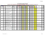
1.5 AREA<br />
The District has a Geographically area of 8206 Square K.Ms. Which is 5.27% of the<br />
total Geographical area of the state. The percentage of plain land is comparatively higher than<br />
the high land and hills. The district has a net area sown of 375 thousand hect. Rice being the<br />
staple food of the district the farmers cultivate paddy in both Kharif and Rabi.The Forest cover<br />
stretches over an area of 315 thousand Hect.<br />
Land Use Area(In 000’Hect.)<br />
Forest area 315<br />
Net area shown 375<br />
Misc tree & Groves 22<br />
Permanent Pasture 20<br />
Cultivable Waste 11<br />
Land put to non Agrl.use 60<br />
Barren & uncultivable land 03<br />
Current & other fallow 28<br />
Land use pattern in Ganjam District<br />
3%<br />
2% 1% 7% 0% 3%<br />
46%<br />
(Source District at Glance 2007,DES)<br />
38%<br />
Forest area<br />
Net area shown<br />
Misc tree & Groves<br />
Permanent Pasture<br />
Cultivable Waste<br />
Land put to non<br />
Agrl.use<br />
Barren &<br />
uncultivable land<br />
Current & other<br />
fallow<br />
23