

Morphometric characterization of upstream mountainous watershed using geographic information system (GIS): high valley of Tifnoute-High Moroccan Atlas
Abstract The National park of Toubkal, was creates in 1942, in the High Moroccan Atlas, one of the regions rich in biodiversity, constitutes in addition, a very interesting cultural heritage. Sheltering more the high summits in North of Africa (Toubkal 4167 meter), and is characterized by very important watershed resources. The high valley of Tifnoute is a basin belonged to this Park; the choice of this research topic was guided by the concern of better, to develop, and preserve this Park. The Morphometric and environmental analysis gives us a general idea about drainage of water, and different characteristics of watershed .To determine a different parameters of the high valley of Tifnoute we used geographic information system (GIS).The results clearly indicate the basin is characterized by a very high altitudes, dendritic drainage and strong slopes, which can influence the environmental lithologie in the study area.
Abstract
The National park of Toubkal, was creates in 1942, in the High Moroccan Atlas, one of the regions rich in biodiversity, constitutes in addition, a very interesting cultural heritage. Sheltering more the high summits in North of Africa (Toubkal 4167 meter), and is characterized by very important watershed resources. The high valley of Tifnoute is a basin belonged to this Park; the choice of this research topic was guided by the concern of better, to develop, and preserve this Park. The Morphometric and environmental analysis gives us a general idea about drainage of water, and different characteristics of watershed .To determine a different parameters of the high valley of Tifnoute we used geographic information system (GIS).The results clearly indicate the basin is characterized by a very high altitudes, dendritic drainage and strong slopes, which can influence the environmental lithologie in the study area.

You also want an ePaper? Increase the reach of your titles
YUMPU automatically turns print PDFs into web optimized ePapers that Google loves.
J. Bio. & Env. Sci. 2014<br />
Results and discussions<br />
Morphometry is the measurement and mathematical<br />
analysis <strong>of</strong> the configuration <strong>of</strong> the earth’s surface,<br />
shape and dimensions <strong>of</strong> its landforms (Clarke ,1996,<br />
Rekha et al., 2011,Magesh et al., 2013 ). In the order<br />
to characterize the physical environnement <strong>of</strong> the<br />
<strong>high</strong> <strong>valley</strong> <strong>of</strong> <strong>Tifnoute</strong>, we determinate the<br />
morphometric parameters <strong>of</strong> the catchment area. The<br />
results <strong>of</strong> morphometric analysis <strong>of</strong> the <strong>watershed</strong> are<br />
shown in the (Table 1).<br />
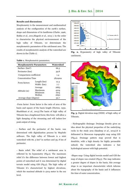
Fig. 2. Hypsometry <strong>of</strong> <strong>high</strong> <strong>valley</strong> <strong>of</strong> <strong>Tifnoute</strong><br />
catchment.<br />
Table 1. <strong>Morphometric</strong> parameters.<br />
<strong>Morphometric</strong> Parameters<br />
Watershed<br />
Surface (km²) 66.3<br />
Perimeter (km) 39.8<br />
Compactness coefficient 1.4<br />
Concentration Time<br />
2h24mn<br />
Form factors<br />
Length (km) 12.3<br />
Width (km) 7.7<br />
Average 2663<br />
Altitude (m) Maximum 4104<br />
Minimum 1675<br />
Median 2650<br />
Average slope (degree) 32.7<br />
-Form factor: Form factor is the ratio <strong>of</strong> area <strong>of</strong> the<br />
basin and square <strong>of</strong> the basin length (Horton, 1932,<br />
Shashikant et al., 2013).The basin <strong>of</strong> <strong>high</strong> <strong>valley</strong> <strong>of</strong><br />
<strong>Tifnoute</strong> has a lengthened form; this form will allow a<br />
light damping <strong>of</strong> the streaming and will induce low<br />
peak output <strong>of</strong> rising.<br />
- Surface and the perimeter <strong>of</strong> the basin: was<br />
determined with digitalization process by MapInfo<br />
s<strong>of</strong>tware. The <strong>high</strong> <strong>valley</strong> <strong>of</strong> <strong>Tifnoute</strong> is a mini<br />
<strong>watershed</strong> with 66, 3 km² in surface and 39, 8 km <strong>of</strong><br />
perimeter.<br />
- Basin relief: The relief <strong>of</strong> a catchment area is<br />
reflected by its hypsometry (Fig.2). The maximum<br />
relief it’s the difference between lowest and <strong>high</strong>est<br />
points <strong>of</strong> <strong>watershed</strong> and it was determined by digital<br />
terrain model <strong>using</strong> GIS (Fig.3). The <strong>high</strong> <strong>valley</strong> <strong>of</strong><br />
<strong>Tifnoute</strong> it’s characterized by <strong>high</strong>est elevations,<br />
which the maximal altitude is 4104 meter in the sea<br />
level.<br />
Fig. 3. Digital elevation map (DEM) <strong>of</strong> <strong>high</strong> <strong>valley</strong> <strong>of</strong><br />
<strong>Tifnoute</strong>.<br />
- Hydrographic drainage: Drainage density gives an<br />
idea about the physical properties <strong>of</strong> the underlying<br />
rocks in the study area (Sandeep et al., 2013).It is<br />
delineated in <strong>Moroccan</strong> topographic map <strong>using</strong> GIS<br />
(Fig.4). Drainage pattern map proved that is<br />
dendritic, with a <strong>high</strong> density for <strong>high</strong>ly permeable<br />
subsoil; the <strong>watershed</strong> also indicates a fast<br />
hydrological answer with <strong>high</strong> potential.<br />
-Slopes map: Using digital terrain model and GIS the<br />
map <strong>of</strong> slopes was created (Fig.5). The map indicates<br />
a greater degree <strong>of</strong> slopes in the basin, this average<br />
slope is an important characteristic which informs<br />
about the topography <strong>of</strong> the basin and it influences<br />
the time <strong>of</strong> water concentration.<br />
64 | Kacem et al.

![Review on: impact of seed rates and method of sowing on yield and yield related traits of Teff [Eragrostis teff (Zucc.) Trotter] | IJAAR @yumpu](https://documents.yumpu.com/000/066/025/853/c0a2f1eefa2ed71422e741fbc2b37a5fd6200cb1/6b7767675149533469736965546e4c6a4e57325054773d3d/4f6e6531383245617a537a49397878747846574858513d3d.jpg?AWSAccessKeyId=AKIAICNEWSPSEKTJ5M3Q&Expires=1720296000&Signature=EZp0bBeXYcL2Id4z9PXmvM5qzEQ%3D)


