Integrated Cross-Sectorial Plan of Tirana-Durres Area
The Albanian Government and the National Spatial Plan have identified the Tiranë-Durrës area, as one of the most important economic areas of the country, and of the Balkan region. To ensure a sustainable territorial and urban development of this area, the Ministry of Urban Development in cooperation with the National Territorial Planning Agency has taken the initiative to draft a Cross-sectoral Integrated Plan for the economic area Tiranë – Durrës. The metropolitan region under study includes territories administered by 5 municipalities: Tiranë, Durrës, Vorë, Shijak, Kamëz. The Albanian Government and the National Spatial Plan have identified the Tiranë-Durrës area, as one of the most important economic areas of the country, and of the Balkan region. To ensure a sustainable territorial and urban development of this area, the Ministry of Urban Development in cooperation with the National Territorial Planning Agency has taken the initiative to draft a Cross-sectoral Integrated Plan for the economic area Tiranë – Durrës. The metropolitan region under study includes territories administered by 5 municipalities: Tiranë, Durrës, Vorë, Shijak, Kamëz.
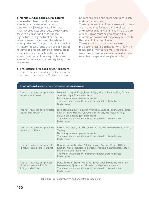
c) Marginal rural, agricultural-natural areas, which have a weak development structure or dispersed urbanization development (development of formal or informal urbanization) should be developed focused on opportunities to support agriculture, as agricultural and natural reserve areas. Benefits will be achieved through the use of large areas of land mainly in nature-focused functions, such as natural reserves or areas in service of nature, areas in service of cultivated forests, orchards, areas in support of future agriculture and spaces for cultivated species requiring large territories. be kept protected and preserved from urban and rural developments. The interconnection of these areas with urban areas should be focused on natural tourism and recreational functions. The infrastructure of these areas must be accompanied by information boards and temporary services to the benefit of natural tourism. The minimal use of these ecosystem protection areas is suggested, with the main focus being: river deltas, wetland areas, water system and resources, coastal forests, mountain ranges and peripheral hills. d) Free natural areas and protected natural areas are the peripheral part of the impact of urban and rural pressure. These areas should Free natural areas and protected natural areas Free natural areas and protected natural areas Tirana Free natural areas and protected natural areas Durres Free natural areas and protected natural areas Kamez Free natural areas and protected natural areas Vore, Marqinet Free natural areas and protected natural areas Sukth, Sukth i ri, Shijak, Xhafzotaj Mountain range of Kruja, Park of Dajti, Hills of Ibe, Kus, Kuc, Durisht, Shalqize, Shpat (Baldushk), Peze; Natural system and geo-monuments; The water system and the nearby peripheral protected areas (buffer zone). Hills of Currila Durres, Erzen river delta, Cape of Rodon, Shetaj, Drac, Lake of Tarini, Manskuri, Krymedhenj, Gjuze, Bozaxije, Kercukje; Natural system and geo-monuments; The water system and the nearby peripheral protected areas (buffer zone). Lake of Paskuqan, Zall Herr, Pinar, Virjon, Kallmet reservoirs, Qinam, Tapize; Natural system and geo-monuments; The water system and the nearby peripheral protected areas (buffer zone). Cape of Rodon, Adriatik, Patoku Lagoon, Safetaj, Preze, Hills of Kashari, Kuç, Shesh Ndroq, Kerçukje (regional natural park); Natural system and geo-monuments; The water system and the nearby peripheral protected areas (buffer zone. Porto Romano, Erzen river delta, Bay of Lalzi, Shkallnur, Manskuri, Muharremaj, Gjuze; Natural system and geo-monuments; The water system and the nearby peripheral protected areas (buffer zone). Table 4.16 Free natural areas and protected natural areas 130
RP1.1- Consolidation and use of agricultural land The agricultural system is formed by the entirety of lands and territories with similar categories of use in agriculture (B). The result of the interaction between the use of territorial values and human activities for cultivation and construction of an agricultural character forms the agricultural system and the chain of food industry. The agricultural system has been used as a basic element to develop territorial development scenarios in rural areas, focusing on: • Reducing the fragmentation of agricultural land, to ensure increased efficiency in farmers’ productivity. • Densification, concentration and access to services in function of agriculture, to increase the use of agricultural network by farmers’ groups, and to increase farm size and seasonal / annual product; • Creating a climate for the development of supportive policies to plant land with suitable autochthonous plants for high-yielding areas that are related or contribute to other areas of agriculture such as livestock, poultry, apiculture etc. The instruments that will mostly affect the return or use of land as agricultural land are: support and promotion based on the product yeild quantity, financial and legal incentives to use local inputs, incentives based on some selective criteria (surface area, number of cattle, income etc). These factors will enable to increase welfare in rural areas and to develop productivity on agricultural land. Meanwhile, incentives and development instruments that are not based on type or the amount of product produced have a wider impact on peri-urban areas where the territory and services are linked to auxiliary urban functions. Land consolidation and enlargement of farms could mark the turning point of the development of agriculture and rural economy, as well as the limitation of agricultural land degradation. The consolidation of agricultural land is an effective instrument for a more competitive agrarian sector, focused on the development and growth of areas of fragmented land plots for agricultural use in rural areas. The line ministry and the municipalities of the region should develop policies based on this instrument, in order to create opportunities for a unification of agricultural farms, promoting agglomerations with similar services, aiming to create 5 to 7 hectares of plots with the same product. Initially, it is recommended to carry out pilot projects in order to further develop the regional strategy on land consolidation and management. It is recommended to build and develop offices in each municipality for the management of agricultural land, establishment of the digital cadastre, contracting of companies for the implementation of the consolidation strategy, and companies to supervise its process. This proccess should be based on: • Clarifying the ownership status in the digital cadastre; • Classifying the price of agricultural land for purchase, sale or rent; • Classifying the crediting categories for purchasing or renting agricultural land. The approach for consolidation and management of agricultural land: The most effective way of building this rural development instrument is the full and comprehensive consolidation, but there are other opportunities as well, such as simplified consolidation or consolidation of voluntary groups. The municipalities are encouraged to develop pilot projects in advance, and then apply large-scale consolidation. The objectives of the consolidation of agricultural land are: • grouping dispersed agricultural plots to minimize the negative effects of the fragmentation of agricultural land; 131
- Page 82 and 83: Various services may be needed for
- Page 84 and 85: • Creating a climate of trust, co
- Page 86 and 87: Dimensionet e ndryshme të një kla
- Page 88 and 89: There are a number of mechanisms wh
- Page 90 and 91: problems, to run R & D, or to devel
- Page 92 and 93: EP5- Territorial economic developme
- Page 94 and 95: For further economic development an
- Page 96 and 97: EP6- Regional branding and tourism
- Page 98 and 99: • Establishing areas for fairs, e
- Page 100 and 101: EP6.3- City and weekend tourism The
- Page 102 and 103: • Creating food festivals and com
- Page 104 and 105: Travel agents Tour operators Public
- Page 106 and 107: Guidelines for the development of u
- Page 108 and 109: participation of visitors intereste
- Page 110 and 111: 4.2 Urban development policies URBA
- Page 112 and 113: Metropolis Primary centre Secondary
- Page 114 and 115: Metropolis Primary centre Secondary
- Page 116 and 117: The plan promotes the consolidation
- Page 118 and 119: UP2.2- Regeneration of urban poles
- Page 120 and 121: Ishëm Thumanë Cudhi KRUJË Bubq F
- Page 122 and 123: Zonat informale për zhvillim dhe i
- Page 124 and 125: UP5- Comprehensive regional communi
- Page 126 and 127: further affect a better management
- Page 128 and 129: Adriatik Mamurras Ishëm Gramëz Th
- Page 130 and 131: Rural regeneration policies aim at
- Page 134 and 135: • increasing revenues from agricu
- Page 136 and 137: Muncipalities Tirana Durres Kamez D
- Page 138 and 139: • Creating the network and chain
- Page 140 and 141: RP4- Economic development of privat
- Page 142 and 143: • The expansion of the network of
- Page 144 and 145: Type of tourism Natural tourism Agr
- Page 146 and 147: Ishëm Thumanë Cudhi KRUJË Bubq F
- Page 148 and 149: The region will provide fast and se
- Page 150 and 151: Spatial poles and strategic corrido
- Page 152 and 153: Measures to improve road safety Loc
- Page 154 and 155: E762 Ishëm Thumanë Cudhi KRUJË B
- Page 156 and 157: Ishëm Thumanë Cudhi KRUJË Bubq F
- Page 158 and 159: EP1- Conservation of natural landsc
- Page 160 and 161: EP2- Protection and management of s
- Page 162 and 163: GREEN GREEN / GREY GREY Natural res
- Page 164 and 165: EP5- Regional waste management The
- Page 166 and 167: EP6- Climate changes Mitigation and
- Page 168 and 169: EP7- Monitoring environmental quali
- Page 170 and 171: 5Strategic projects regulations
- Page 172 and 173: SP1. Economic development Priority
- Page 174 and 175: Priority / Policy Specific project
- Page 176 and 177: Priority / Policy Specific project
- Page 178 and 179: Priority / Policy Specific project
- Page 180 and 181: Priority / Policy Specific project
c) Marginal rural, agricultural-natural<br />
areas, which have a weak development<br />
structure or dispersed urbanization<br />
development (development <strong>of</strong> formal or<br />
informal urbanization) should be developed<br />
focused on opportunities to support<br />
agriculture, as agricultural and natural<br />
reserve areas. Benefits will be achieved<br />
through the use <strong>of</strong> large areas <strong>of</strong> land mainly<br />
in nature-focused functions, such as natural<br />
reserves or areas in service <strong>of</strong> nature, areas<br />
in service <strong>of</strong> cultivated forests, orchards,<br />
areas in support <strong>of</strong> future agriculture and<br />
spaces for cultivated species requiring large<br />
territories.<br />
be kept protected and preserved from urban<br />
and rural developments.<br />
The interconnection <strong>of</strong> these areas with urban<br />
areas should be focused on natural tourism<br />
and recreational functions. The infrastructure<br />
<strong>of</strong> these areas must be accompanied by<br />
information boards and temporary services to<br />
the benefit <strong>of</strong> natural tourism.<br />
The minimal use <strong>of</strong> these ecosystem<br />
protection areas is suggested, with the main<br />
focus being: river deltas, wetland areas,<br />
water system and resources, coastal forests,<br />
mountain ranges and peripheral hills.<br />
d) Free natural areas and protected natural<br />
areas are the peripheral part <strong>of</strong> the impact <strong>of</strong><br />
urban and rural pressure. These areas should<br />
Free natural areas and protected natural areas<br />
Free natural areas and protected<br />
natural areas <strong>Tirana</strong><br />
Free natural areas and protected<br />
natural areas <strong>Durres</strong><br />
Free natural areas and protected<br />
natural areas Kamez<br />
Free natural areas and protected<br />
natural areas Vore, Marqinet<br />
Free natural areas and protected<br />
natural areas Sukth, Sukth i<br />
ri, Shijak, Xhafzotaj<br />
Mountain range <strong>of</strong> Kruja, Park <strong>of</strong> Dajti, Hills <strong>of</strong> Ibe, Kus, Kuc, Durisht,<br />
Shalqize, Shpat (Baldushk), Peze;<br />
Natural system and geo-monuments;<br />
The water system and the nearby peripheral protected areas<br />
(buffer zone).<br />
Hills <strong>of</strong> Currila <strong>Durres</strong>, Erzen river delta, Cape <strong>of</strong> Rodon, Shetaj, Drac,<br />
Lake <strong>of</strong> Tarini, Manskuri, Krymedhenj, Gjuze, Bozaxije, Kercukje;<br />
Natural system and geo-monuments;<br />
The water system and the nearby peripheral protected areas<br />
(buffer zone).<br />
Lake <strong>of</strong> Paskuqan, Zall Herr, Pinar, Virjon, Kallmet reservoirs, Qinam,<br />
Tapize;<br />
Natural system and geo-monuments;<br />
The water system and the nearby peripheral protected areas<br />
(buffer zone).<br />
Cape <strong>of</strong> Rodon, Adriatik, Patoku Lagoon, Safetaj, Preze, Hills <strong>of</strong><br />
Kashari, Kuç, Shesh Ndroq, Kerçukje (regional natural park); Natural<br />
system and geo-monuments;<br />
The water system and the nearby peripheral protected areas<br />
(buffer zone.<br />
Porto Romano, Erzen river delta, Bay <strong>of</strong> Lalzi, Shkallnur, Manskuri,<br />
Muharremaj, Gjuze; Natural system and geo-monuments;<br />
The water system and the nearby peripheral protected areas<br />
(buffer zone).<br />
Table 4.16 Free natural areas and protected natural areas<br />
130


