Acoem Integro LIDAR Network brochure
Acoem Integro LIDAR Network brochure
Acoem Integro LIDAR Network brochure

Create successful ePaper yourself
Turn your PDF publications into a flip-book with our unique Google optimized e-Paper software.
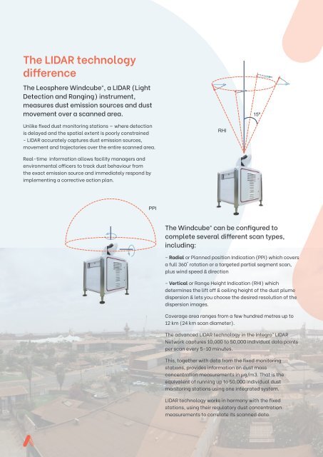
The <strong>LIDAR</strong> technology<br />
difference<br />
The Leosphere Windcube®, a <strong>LIDAR</strong> (Light<br />
Detection and Ranging) instrument,<br />
measures dust emission sources and dust<br />
movement over a scanned area.<br />
15º<br />
Unlike fixed dust monitoring stations — where detection<br />
is delayed and the spatial extent is poorly constrained<br />
- <strong>LIDAR</strong> accurately captures dust emission sources,<br />
movement and trajectories over the entire scanned area.<br />
RHI<br />
Real-time information allows facility managers and<br />
environmental officers to track dust behaviour from<br />
the exact emission source and immediately respond by<br />
implementing a corrective action plan.<br />
PPI<br />
The Windcube® can be configured to<br />
complete several different scan types,<br />
including:<br />
- Radial or Planned position Indication (PPI) which covers<br />
a full 360° rotation or a targeted partial segment scan,<br />
plus wind speed & direction<br />
- Vertical or Range Height Indication (RHI) which<br />
determines the lift off & ceiling height of the dust plume<br />
dispersion & lets you choose the desired resolution of the<br />
dispersion images.<br />
Coverage area ranges from a few hundred metres up to<br />
12 km (24 km scan diameter).<br />
The advanced <strong>LIDAR</strong> technology in the <strong>Integro</strong> <strong>LIDAR</strong><br />
<strong>Network</strong> captures 10,000 to 50,000 individual data points<br />
per scan every 5-10 minutes.<br />
This, together with data from the fixed monitoring<br />
stations, provides information on dust mass<br />
concentration measurements in µg/m3. That is the<br />
equivalent of running up to 50,000 individual dust<br />
monitoring stations using one integrated system.<br />
<strong>LIDAR</strong> technology works in harmony with the fixed<br />
stations, using their regulatory dust concentration<br />
measurements to correlate its scanned data.