

Brahamaputra Basin

Create successful ePaper yourself
Turn your PDF publications into a flip-book with our unique Google optimized e-Paper software.
<strong>Brahamaputra</strong> <strong>Basin</strong><br />
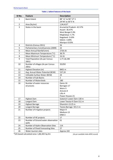
Table 1. Salient features of the basin<br />
Sl No. Feature Description<br />
1 <strong>Basin</strong> Extent 88° 11' to 96° 57' E<br />
24°44’ to 30°3' N<br />
2 Area (Sq.km) 1,94,413*<br />
3 States in the basin Arunachal Pradesh- 42.57%<br />
Assam- 36.47%<br />
West Bengal-5.9%<br />
Meghalaya- 5.7%<br />
Nagaland- 5.63%<br />
Sikkim- 3.69%<br />
Manipur-0.03%<br />
4 Districts (Census 2011) 56<br />
5 Parliamentary Constituencies (2009) 22<br />
6 Mean Annual Rainfall (mm) 2720.35<br />
7 Mean Maximum Temperature ( o C) 38.79<br />
8 Mean Minimum Temperature ( o C) 16.16<br />
9 Total Population (As per Census 1,77,18,190<br />
2001)<br />
10 Number of villages (As per Census 20,050<br />
2001)<br />
11 Highest Elevation (m) 8401 m<br />
12 Avg. Annual Water Potential (BCM) 537.24<br />
13 Utilizable Surface Water (BCM) 24<br />
14 Number of Sub <strong>Basin</strong>s 2<br />
15 Number of Watersheds 180<br />
16 Number of water resources<br />
Dams-16<br />
structures<br />
Barrages-17<br />
Weirs-5<br />
Anicuts-0<br />
Lifts-4<br />
Power Houses-21<br />
17 Highest Dam Subansiri Lower Dam-130 m<br />
18 Longest Dam Lower Teesta-IV Dam-511 m<br />
19 Highest Barrage Dhanishri-13.25 m<br />
20 Longest Barrage Teesta Barrage- 921.5 m<br />
21 Number of Irrigation projects Major-9<br />
Medium-13<br />
ERM-3<br />
22 Number of HE projects 17<br />
23 Number of Ground water observation 61<br />
wells<br />
24 Number of Hydro-Observation Sites 114<br />
25 Number of Flood Forecasting Sites 27<br />
26 Water tourism sites Approx.102<br />
*GIS based calculated area: 1,86,365 Sq.Km<br />
(As per available India-WRIS record)<br />
4