

Brahamaputra Basin

You also want an ePaper? Increase the reach of your titles
YUMPU automatically turns print PDFs into web optimized ePapers that Google loves.
<strong>Brahamaputra</strong> <strong>Basin</strong><br />
Version 2.0<br />
www.india-wris.nrsc.gov.in
<strong>Brahamaputra</strong> <strong>Basin</strong><br />
Preface<br />
Optimal management of water resources is the necessity of time in the wake of development and<br />
growing need of population of India. The National Water Policy of India (2002) recognizes that<br />
development and management of water resources need to be governed by national perspectives in<br />
order to develop and conserve the scarce water resources in an integrated and environmentally<br />
sound basis. The policy emphasizes the need for effective management of water resources by<br />
intensifying research efforts in use of remote sensing technology and developing an information<br />
system. In this reference a Memorandum of Understanding (MoU) was signed on December 3, 2008<br />
between the Central Water Commission (CWC) and National Remote Sensing Centre (NRSC), Indian<br />
Space Research Organisation (ISRO) to execute the project “Generation of Database and<br />
Implementation of Web enabled Water resources Information System in the Country” short named<br />
as India-WRIS WebGIS.<br />
India-WRIS WebGIS has been developed and is in public domain since December 2010 (www.indiawris.nrsc.gov.in).<br />
It provides a ‘Single Window solution’ for all water resources data and information<br />
in a standardized national GIS framework and allow users to search, access, visualize, understand<br />
and analyze comprehensive and contextual water resources data and information for planning,<br />
development and Integrated Water Resources Management (IWRM).<br />
<strong>Basin</strong> is recognized as the ideal and practical unit of water resources management because it allows<br />
the holistic understanding of upstream-downstream hydrological interactions and solutions for<br />
management for all competing sectors of water demand. The practice of basin planning has<br />
developed due to the changing demands on river systems and the changing conditions of rivers by<br />
human interventions. The multiple uses of water and varying demands on a river basin require an<br />
integrated approach to managing river basin.<br />
<strong>Basin</strong> wise report generation is one the important deliverables of India-WRIS project. Report of<br />
<strong>Brahamaputra</strong> <strong>Basin</strong> describes systematically the present status of water resources: major water<br />
resources projects, hydro-meteorological observations, surface and ground water development<br />
scenario, topographic characteristics, climatic variability, land use / land cover pattern & allied<br />
natural resources along with socio-economic profile of the basin. The report contains valuable latest<br />
information of the basin on all aspects of water resources and allied sectors and will be useful as<br />
baseline information for the irrigation officials, hydrologists, agriculturalists, conservationists,<br />
research organizations and all those involved in the development of <strong>Brahamaputra</strong> <strong>Basin</strong>.<br />
ii
<strong>Brahamaputra</strong> <strong>Basin</strong><br />
Acknowledgements<br />
The <strong>Brahamaputra</strong> <strong>Basin</strong> report is an outcome of the project “Generation of Database and<br />
Implementation of Web enabled Water resources Information System in the Country” short named<br />
as India-WRIS WebGIS jointly executed by the Central Water Commission (CWC) and National<br />
Remote Sensing Centre (NRSC), Indian Space Research Organization (ISRO). This comprehensive<br />
publication gives the present status of water resources assets, topographic features, climatic<br />
variability, land use / land cover pattern & allied natural resources along with socio-economic<br />
information of the basin.<br />
We, on behalf of the authors and India-WRIS project team acknowledge; Shri Alok Rawat, Secretary,<br />
Ministry of Water Resources; Mrs. Sudha Midha, Additional Secretary, Ministry of Water<br />
Resources; Er. A. B. Pandya, Chairman, Central Water Commission; Dr. K. Radhakrishnan, Chairman,<br />
Indian Space Research Organization and Secretary, Department of Space; Shri Sudarsanam<br />
Srinivasan, Secretary to GOI and Member- Finance, Department of Space; Shri A. Vijay Anand,<br />
Additional Secretary, Department of Space; Dr. V. Koteswara Rao, Scientific Secretary, ISRO; Dr. V.<br />
Jayaraman, Ex-Director, NRSC for constant encouragement and guidance, technical discussions and<br />
for evincing keen interest in India-WRIS project and this report.<br />
Our foremost acknowledgement is towards India-WRIS project team who created and<br />
organized large number of data sets and information in GIS format as seamless layers and attribute<br />
data for the entire country which served as base for this report. Thanks are also due to all CWC and<br />
NRSC / ISRO officials who carried out the quality assurance and shown their enthusiastic<br />
involvement. Finally, our sincere thanks are to all divisions and officials of NRSC and CWC for their<br />
valuable support during the preparation of this report.<br />
The basin report includes the results generated through interpretation of latest satellite imageries as<br />
well as compilation of huge information from voluminous records. This would not have been<br />
possible without the countrywide support. We would like to thank all the organizations, institutes<br />
and individuals who contributed either directly or indirectly in bringing out this publication.<br />
Dr. J R Sharma<br />
Project Director, India-WRIS &<br />
Chief General Manager, RCs/ NRSC/ ISRO, New Delhi<br />
Er. Yogesh Paithankar<br />
Project In-charge, India-WRIS &<br />
Director, CWC, New Delhi<br />
ii
<strong>Brahamaputra</strong> <strong>Basin</strong><br />
Executive summary<br />
Brahmaputra basin spreads over 580,000 Sq.km spreads over China (50.5%), India (33.6%),<br />
Bangladesh (8.1%) and Bhutan (7.8%). Although the main river does not flow through the kingdom of<br />
Bhutan, 96 % of Bhutan’s area falls under this <strong>Basin</strong>. In India, the catchment area spreads over states<br />
of Arunachal Pradesh, Assam, West Bengal, Meghalaya, Nagaland and Sikkim covering 1,94,413 Sq.<br />
km. which is nearly 5.9 % of the total geographical area of the country. The basin lies between<br />
88°11’ to 96°57’ east longitudes and 24°44’ to 30°3’ north latitudes. The upper portion of the basin<br />
(Indian part) lying in Arunachal Pradesh, Nagaland and the some lower portion of the basin falling in<br />
Sikkim is mostly mountain ranges and narrow valleys.<br />
Most portion of the basin lying in Assam and Meghalaya consists of hills, forests and the wide<br />
Brahmaputra valley about 80 km wide on the average. In West Bengal, also, the basin covers of hills<br />
and forests besides the plains in the districts of Koch Behar and Jalpaiguri. Brahmaputra basin in<br />
Indian portion experience winter, summer, monsoon and autum/post-monsoon season.The basin<br />
experience heavy rainfall. The distribution of rainfall in the Brahmaputra basin is different at<br />
different parts of the basin. In southern slopes of Himalayan region falling in this basin experiences<br />
rainfall is over 6000 mm. The minimum and maximum temperature of the basin is 16.16°C and<br />
38.79°C respectively. The higher elevation in the Himalayan ranges experience lower temperatures<br />
and snowfall also.<br />
The catchment area of Brahmaputra River in India, receives a number of tributaries at its north and<br />
south banks. Crop fields, extensive forest cover, tea plantations, grazing land and water logged<br />
swampy areas with a huge network of tributaries are commonly observed components of the<br />
landuse/cover of the Brahmaputra basin. The major part of basin is covered with forest accounting<br />
to 55.48% of the total area. The most predominant soil type found in the basin is the red loamy soil<br />
and alluvial soil. Other important soil types are sandy, loamy, clayey soils, their combinations and<br />
laterite soils. The entire Brahmaputra basin falls in the Eastern Himalayan agro-climatic zone<br />
(Planning commission, 1989). Brahmaputra basin falls in 3 agro-ecological zones. Most of the upper<br />
Brahmaputra sub basin area falls in the ‘Warm perhumid eco-region with brown and red hill soils’.<br />
The Brahmaputra Valley area is dominating by ‘Hot subhumid (moist) to humid (inclusion of<br />
perhumid) eco-regions with alluvial-derived soils’. The lowermost part of the basin is falling in the<br />
‘Warm perhumid eco-region with red and lateritic soils’.<br />
The basin spreads over 22 parliamentary constituencies (2009) comprising 12 of Assam, 4 of West<br />
Bengal, 2 of Arunachal Pradesh, 2 of Meghalaya, 1 of Sikkim and 1 of Nagaland. The total no. of<br />
villages falling in the basin is 20,050 with 33,72,532 no. of households. The total population in this<br />
basin is 1,77,18,190 (Census,2001). The plain region (the Brahmaputra valley) is densely populated in<br />
comparision to the hilly region of this basin. Majority of population is dependent on agriculture and<br />
allied land based activities. Shifting cultivation (slash and burn agriculture) is still the chief means of<br />
livelihood of tribal people. Brahmaputra basin is also rich in mineral resource especially the<br />
Brahmaputra valley.<br />
The Brahmaputra <strong>Basin</strong> constitutes of two major sub basins “Brahmaputra Upper” and<br />
“Brahmaputra Lower”. The Brahmaputra is further divided into 180 watersheds. The Brahmaputra<br />
Upper and the Lower sub basin comprised of 97 and 83 watersheds respectively. The Brahmaputra<br />
and its tributaries carry more than 30 % of the total water resources potential of the country.<br />
iii
<strong>Brahamaputra</strong> <strong>Basin</strong><br />
Besides, this region has the highest per capita and per hectare availability of water in the country<br />
and possesses as much as 41 per cent of the country's total hydropower potential. The average<br />
annual water potential and the utilizable surface water of the basin are 537.24 BMC and 24 BCM<br />
respectively. Prior to independence, little thought was given towards water resources development<br />
in Brahmaputra valley. In the Brahmaputra basin the development of irrigation started after the 3rd<br />
five year plan. Lower Subansiri & Ranganadi of Arunachal Pradesh, Khandong Dam of Meghalaya,<br />
Doyang dam of Nagaland, & Rangit-III Dam of Sikkim are few major dams constructed across<br />
Brahmaputra and its tributaries. Barrages associated with the major and medium irrigation projects<br />
of this basin are Teesta, Dhansiri, Barolia, Jaldhaka, Burisuti, Garufella, Dzuza,<br />
Baradikarai,Champamati, Longa, Bhumki barrage ect. Important weirs constructed in this region are<br />
Sukla, Jamuna, Umiam-Umtru and Pahumura weir.The main purpose of barrages and weirs<br />
constructed in the basin is Irrigation. Dams constructed in this basin are basically to tap the immense<br />
hydropower potential of this region.The Brahmaputra basin has abundant hydropower<br />
potential.Several hydropower projects of this region like the Kopili (200 MW), Khandong (75 MW),<br />
Karbi Langpi (100 MW) of Assam, Lower Subansiri (2,000 MW), Dibang (3000 MW), Kameng (600<br />
MW), and Ranganadi (405 MW) of Arunachal Pradesh, Teesta-V (510 MW) of West Bengal,Umiam-<br />
Umtru Power Complex (174 MW) of Meghalaya etc. are presently at various stages of operation,<br />
development and planning.<br />
There are 27 gauge sites, 5 gauge discharge sites, 40 gauge quality sites, 14 gauge discharge quality<br />
sites, 10 gauge discharge sediment sites, and 18 gauge discharge sediment quality sites in the basin<br />
which are maintained by Central Water Commission (CWC) for the study of hydro-meteorological<br />
observations. The Central Water Commission also operates 27 flood forecasting stations for Level<br />
forecast in the basin.<br />
The basin has good quality of ground water except for high dissolved iron content at some places,<br />
though very few places are affected by salinity. Arsenic contamination in groundwater is also<br />
reported in the Brahmaputra flood plain of Assam.<br />
National Water Development Authority has proposed to connect the Brahmaputra River/ tributaries<br />
to Ganga <strong>Basin</strong> to transfer its surplus water to the water scarce regions. These 2 links are : i) Manas-<br />
Sankosh-Tista-Ganga Link which will joins Manas River to Ganga River via Sankosh and Teesta Rivers<br />
and ii) the Jogighopa-Tista-Farakka Link which will join Brahmaputra River (Jogighopa Barrage) to<br />
Ganga River (Farakka Barrage).<br />
Due to large deltaic plain, Inland navigation is an important and popular mode of traffic transport in<br />
this basin. Brahmaputra from Dhubri to Sadiya was declared as National Waterway no.2. Some<br />
tributaries of Brahmaputra are navigable throughout the year by country boats.<br />
Flood, Drastic bank line changes and severe bank erosion are grave problems of this basin.<br />
The Brahmaputra basin in India shows, such a huge water resources potential which provides lot of<br />
scope for developmental activities for hydropower, navigation, irrigation, pisciculture, recreation<br />
etc.<br />
iv
<strong>Brahamaputra</strong> <strong>Basin</strong><br />
Table of Contents<br />
Preface --------------------------------------------------------------------------------------------------------------------------i<br />
Acknowledgements ------------------------------------------------------------------------------------------------------------------ ii<br />
Executive summary ------------------------------------------------------------------------------------------------------------------ iii<br />
1.Introduction<br />
1.1 Overview of basin -------------------------------------------------------------------------------------------------------- 1<br />
1.2 Topography --------------------------------------------------------------------------------------------------------------- 8<br />
1.3 Climate ------------------------------------------------------------------------------------------------------------------- 11<br />
1.3.1 Rainfall ----------------------------------------------------------------------------------------------------- 11<br />
1.3.2 Temperature ---------------------------------------------------------------------------------------------- 12<br />
1.3.3 Trends and variability ----------------------------------------------------------------------------------- 14<br />
1.4 Major rivers ------------------------------------------------------------------------------------------------------------- 15<br />
1.5 Land use/land cover --------------------------------------------------------------------------------------------------- 18<br />
1.6 Soils ----------------------------------------------------------------------------------------------------------------------- 19<br />
1.7 Agro-climatic zones ---------------------------------------------------------------------------------------------------- 21<br />
1.8 Agro-ecological zones ------------------------------------------------------------------------------------------------- 21<br />
1.9 Demography ------------------------------------------------------------------------------------------------------------ 26<br />
2. Hydrological units<br />
2.1 Sub-basins --------------------------------------------------------------------------------------------------------------- 28<br />
2.2 Watersheds ----------------------------------------------------------------------------------------------------------------------- 28<br />
3. Surface water resources<br />
3.1 Surface waterbodies -------------------------------------------------------------------------------------------------- 31<br />
3.2. Water resource projects --------------------------------------------------------------------------------------------- 32<br />
3.2.1 Major and medium irrigation projects --------------------------------------------------------------------- 32<br />
3.2.2 Hydro Electric projects ---------------------------------------------------------------------------------------- 37<br />
3.2.3 Dams, Barrages/Weirs/Anicuts ------------------------------------------------------------------------------ 38<br />
3.2.4 Command area and canal network ------------------------------------------------------------------------- 43<br />
3.2.5 Multipurpose projects ----------------------------------------------------------------------------------------- 44<br />
3.2.6 Interstate projects---------------------------------------------------------------------------------------------- 44<br />
4. Ground water resources<br />
4.1 Ground water observation wells ----------------------------------------------------------------------------------- 46<br />
4.2 Ground water level fluctuation ------------------------------------------------------------------------------------- 48<br />
4.3 Litholog well locations -------------------------------------------------------------------------------------------------------- 51<br />
5. Hydro-met observations<br />
5.1 Hydrological observation sites -------------------------------------------------------------------------------------- 53<br />
5.2 Flood forecasting sites ------------------------------------------------------------------------------------------------ 55<br />
5.3 Meteorological stations ------------------------------------------------------------------------------------------------------ 55<br />
6. Water quality<br />
6.1 Surface water quality observations -------------------------------------------------------------------------------- 56<br />
6.2 Ground water quality observations --------------------------------------------------------------------------------------- 57<br />
7. Inter basin transfer links ---------------------------------------------------------------------------------- 58<br />
8. Inland navigation waterways ---------------------------------------------------------------------------- 60<br />
9. Water tourism sites ----------------------------------------------------------------------------------------- 62<br />
10. Conclusion --------------------------------------------------------------------------------------------------- 65<br />
Annexure I: State, district and parliamentary constituency in the basin --------------------------- 66<br />
Annexure II : Climate – Rainfall (1971-2004) and Temperature (1969-2004)<br />
profile in the basin------------------------------------------------------------------------------------------- 70<br />
Annexure III : Sub basin wise population and drinking water facilities ----------------------------- 72<br />
Annexure IV : Inventory of surface water resources --------------------------------------------------- 75<br />
Annexure V : Inventory of litholog well locations ------------------------------------------------------ 82<br />
www.india-wris.nrsc.gov.in
<strong>Brahamaputra</strong> <strong>Basin</strong><br />
Annexure VI : Salient features of hydro-meteorological stations ------------------------------------ 89<br />
Annexure VII : Inventory of water tourism sites -------------------------------------------------------- 106<br />
Acronyms------------------------------------------------------------------------------------------------------ 113<br />
References ---------------------------------------------------------------------------------------------------- 117<br />
Authors and Project team ---------------------------------------------------------------------------------- 118<br />
List of Tables<br />
Table 1. Salient features of the basin---------------------------------------------------------------------------------------------- 4<br />
Table 2. Brahmaputra <strong>Basin</strong> Major Hydrological Observation Sites------------------------------------------------------- 7<br />
Table 3. Elevation zones-------------------------------------------------------------------------------------------------------------- 9<br />
Table 4. Length of major rivers------------------------------------------------------------------------------------------------------ 16<br />
Table 5. Land use/Land cover statistics (2005-06) ----------------------------------------------------------------------------- 19<br />
Table 6. Sub-basin wise watersheds----------------------------------------------------------------------------------------------- 28<br />
Table 7. Number and size of waterbodies---------------------------------------------------------------------------------------- 31<br />
Table 8. Number of water resources projects ---------------------------------------------------------------------------------- 32<br />
Table 9. Sub-basin wise number and type of water resources structures ----------------------------------------------- 39<br />
Table 10. Sub-basin wise number of ground water observation wells---------------------------------------------------- 46<br />
Table 11. Hydrological observation sites of CWC------------------------------------------------------------------------------- 53<br />
Table 12. Types of flood forecasting stations of CWC------------------------------------------------------------------------- 55<br />
Table 13. Meteorological stations-------------------------------------------------------------------------------------------------- 55<br />
Table 14. Water tourism sites------------------------------------------------------------------------------------------------------- 63<br />
List of Maps<br />
Map 1. Index map---------------------------------------------------------------------------------------------------------------------- 3<br />
Map 2a. Satellite imagery of Brahmaputra <strong>Basin</strong> ------------------------------------------------------------------------------ 5<br />
Map 2b. Brahmaputra <strong>Basin</strong> - Drainage & Sub-basin ------------------------------------------------------------------------- 6<br />
Map 3. Elevation zones --------------------------------------------------------------------------------------------------------------- 10<br />
Map 4. Annual average rainfall----------------------------------------------------------------------------------------------------- 13<br />
Map 5. Land use/land cover (2005-06)-------------------------------------------------------------------------------------------- 20<br />
Map 6. Agro-climatic zones---------------------------------------------------------------------------------------------------------- 24<br />
Map 7. Agro-ecological zones------------------------------------------------------------------------------------------------------- 25<br />
Map 8. Population density----------------------------------------------------------------------------------------------------------- 27<br />
Map 9a. Brahmaputra Upper Sub-basin and watersheds-------------------------------------------------------------------- 29<br />
Map 9b. Brahmaputra Lower Sub-basin and watersheds-------------------------------------------------------------------- 30<br />
Map 10. Major water resources structures and projects--------------------------------------------------------------------- 36<br />
Map 11a. Brahmaputra Upper Sub-basin water resources assets --------------------------------------------------------- 40<br />
Map 11a. Brahmaputra Upper Sub-basin water resources assets --------------------------------------------------------- 41<br />
Map 12. Command area and canal network------------------------------------------------------------------------------------- 45<br />
Map 13. Location of ground water observation wells------------------------------------------------------------------------- 46<br />
Map 14. Ground water level fluctuation (Recharge)--------------------------------------------------------------------------- 49<br />
Map 15. Ground water level fluctuation (Draft)-------------------------------------------------------------------------------- 50<br />
Map 16. Litholog well locations----------------------------------------------------------------------------------------------------- 52<br />
Map 17. Hydro observation and flood forecasting stations------------------------------------------------------------------ 54<br />
Map 18. Inter basin transfer links-------------------------------------------------------------------------------------------------- 59<br />
Map 19. Inland navigation waterways-------------------------------------------------------------------------------------------- 61<br />
Map 20. Water tourism sites-------------------------------------------------------------------------------------------------------- 63<br />
List of Figures<br />
Figure 1. State wise <strong>Basin</strong> area ----------------------------------------------------------------------------------------------------- 2<br />
Figure 2. Monthly average temperature (1969-2004) ------------------------------------------------------------------------ 14<br />
Figure 3. Trend of annual average rainfall (1971-2004)----------------------------------------------------------------------- 14<br />
Figure 4. Sub-basins and percent drainage area-------------------------------------------------------------------------------- 28<br />
Figure 5. Type and number of waterbodies ------------------------------------------------------------------------------------- 32<br />
Figure 6. Dam classification based on storage ---------------------------------------------------------------------------------- 42<br />
Figure 7. Dam classification based on purpose --------------------------------------------------------------------------------- 42<br />
www.india-wris.nrsc.gov.in
<strong>Brahamaputra</strong> <strong>Basin</strong><br />
1.Introduction<br />
1.1 Overview of basin<br />
Brahmaputra basin forms a part of the major water division ‘the rivers draining into Bay of Bengal’.<br />
Based upon the drainage outlet it is further included under the ‘Brahmaputra drainage’water<br />
resources region.<br />
The mighty Brahmaputra River originates in the great glacier mass north from Kailash ranges of<br />
Himalayas at an elevation of 5,150 m just south of the lake called ‘Konggyu Tsho’. The Brahmaputra<br />
River traverses a distance of 2,900 km, through four countries, namely Tibet (China), Bhutan, India<br />
and Bangladesh, before joining the Bay of Bengal. It has an average annual discharge of 19,820<br />
cumec, an average annual sediment load of 735 million metric tonnes, and a specific flood discharge<br />
of 0.149 cumec / Sq.km.<br />
Brahmaputra basin spreads over 580,000 Sq.km which covers China (50.5%), India (33.6%),<br />
Bangladesh (8.1%) and Bhutan (7.8%). Although the main river does not flow through the kingdom of<br />
Bhutan, 96% of Bhutan’s area falls under this basin.The basin is of irregular shape; the maximum<br />
east-west length is 1,540 km and the maximum north-south width is 682 km.<br />
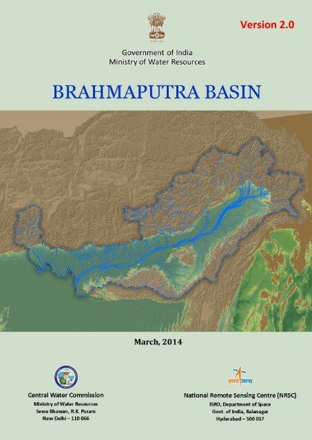
Map 1 shows the geographical location of the basin with terrain features from DEM. The highlighted<br />
blue boundary shows the basin extent overlaid on state boundary. The basin lies between 88°11’ to<br />
96°57’ east longitudes and 24°44’ to 30°3’ north latitudes and covers an area of 1,94,413 Sq.km<br />
which is nearly 5.9% of the total geographical area of the country. In India, the river flows for 916<br />
km. Brahmaputra basin part in India, spreads over states of Arunachal Pradesh, Assam, West Bengal,<br />
Meghalaya, Nagaland and the whole of Sikkim. Brahmaputra basin (in India) is bounded by the<br />
Himalayas on the north, by the Patkai range of hills on the east running along the India-Myanmar<br />
border, by the Assam range of hills on the south and by the Himalayas and the ridge separating it<br />
from Ganga basin on the west. The distribution of the drainage area of Brahmaputra River in the<br />
states of Arunachal Pradesh, Assam, West Bengal, Meghalaya, Nagaland, and Sikkim are 81,424<br />
Sq.km, 70,634 Sq.km, 12,585 Sq.km, 11,667 Sq.km, 10,803 Sq.km and 7,300 Sq.km respectively as<br />
shown through pie chart in Figure 1. Salient features of the basin are listed in Table 1. Map 2a is the<br />
56 m resolution False Colour Composite AWiFS satellite imagery of the Brahmaputra basin. Map 2b<br />
gives a detailed view of the Brahmaputra basin, its sub basins, drainage network and its pattern<br />
across the basin. Major water resources structures (Dam/Barrage/Anicuts), major cities and major<br />
hydro-meteorological observation sites and flood forecasting sites are also shown in the map. The<br />
major hydrological observation sites of Brahmaputra basin are tabulated in Table 2.<br />
The climate throughout the region is damp with humidity around 90%. Variation of atmospheric<br />
temperature is considerably low unlike rest of India. The Brahmaputra catchment is the heaviest<br />
rainfall region in the world. The Brahmaputra basin, particularly the portions in Assam, is notorious<br />
for the annual flood hazards and river bank erosion that create mayhem every year, bringing misery<br />
to the people and shattering the fragile agro-economic base of this region. This basin is seismically<br />
very active falling in the ‘Seismic zone-V’ (except few parts of West Bengal and Sikkim falling in<br />
seismic zone-IV). This sensitive zone is experienced several devastating earthquakes in the past. Part<br />
of the Himalayan Mountains region of Sikkim and Arunachal Pradesh falling in Brahmaputra basin<br />
experience snow cover. Brahmaputra basin represents the greenest part of India, accounting the<br />
maximum 55.48% (107854.26 Sq.km) of forest cover.<br />
1
<strong>Brahamaputra</strong> <strong>Basin</strong><br />
Most interesting feature of the Brahmaputra River, in its middle reach is “Majuli”, the river island, in<br />
Assam, is marked as the largest mid river delta system in the world (UNESCO).<br />
Brahmaputra Board was established by the Govt.of India in 1980 with the objective of preparing a<br />
master plan for controlling the flood and bank erosion and improving the drainage of the<br />
Brahmaputra valley, simultaneously tapping the immense water potential for hydropower<br />
generation and possible irrigation.<br />
Figure 1. State wise <strong>Basin</strong> area<br />
2
<strong>Brahamaputra</strong> <strong>Basin</strong><br />
Map 1. Index map<br />
3
<strong>Brahamaputra</strong> <strong>Basin</strong><br />
Table 1. Salient features of the basin<br />
Sl No. Feature Description<br />
1 <strong>Basin</strong> Extent 88° 11' to 96° 57' E<br />
24°44’ to 30°3' N<br />
2 Area (Sq.km) 1,94,413*<br />
3 States in the basin Arunachal Pradesh- 42.57%<br />
Assam- 36.47%<br />
West Bengal-5.9%<br />
Meghalaya- 5.7%<br />
Nagaland- 5.63%<br />
Sikkim- 3.69%<br />
Manipur-0.03%<br />
4 Districts (Census 2011) 56<br />
5 Parliamentary Constituencies (2009) 22<br />
6 Mean Annual Rainfall (mm) 2720.35<br />
7 Mean Maximum Temperature ( o C) 38.79<br />
8 Mean Minimum Temperature ( o C) 16.16<br />
9 Total Population (As per Census 1,77,18,190<br />
2001)<br />
10 Number of villages (As per Census 20,050<br />
2001)<br />
11 Highest Elevation (m) 8401 m<br />
12 Avg. Annual Water Potential (BCM) 537.24<br />
13 Utilizable Surface Water (BCM) 24<br />
14 Number of Sub <strong>Basin</strong>s 2<br />
15 Number of Watersheds 180<br />
16 Number of water resources<br />
Dams-16<br />
structures<br />
Barrages-17<br />
Weirs-5<br />
Anicuts-0<br />
Lifts-4<br />
Power Houses-21<br />
17 Highest Dam Subansiri Lower Dam-130 m<br />
18 Longest Dam Lower Teesta-IV Dam-511 m<br />
19 Highest Barrage Dhanishri-13.25 m<br />
20 Longest Barrage Teesta Barrage- 921.5 m<br />
21 Number of Irrigation projects Major-9<br />
Medium-13<br />
ERM-3<br />
22 Number of HE projects 17<br />
23 Number of Ground water observation 61<br />
wells<br />
24 Number of Hydro-Observation Sites 114<br />
25 Number of Flood Forecasting Sites 27<br />
26 Water tourism sites Approx.102<br />
*GIS based calculated area: 1,86,365 Sq.Km<br />
(As per available India-WRIS record)<br />
4
<strong>Brahamaputra</strong> <strong>Basin</strong><br />
5<br />
Map 2a. Satellite imagery of Brahmaputra <strong>Basin</strong>
<strong>Brahamaputra</strong> <strong>Basin</strong><br />
6<br />
Map 2b. Brahmaputra <strong>Basin</strong> - Drainage & Sub-basin
<strong>Brahamaputra</strong> <strong>Basin</strong><br />
Table 2.Brahmaputra <strong>Basin</strong> Major Hydrological Observation Sites<br />
1 Tuting (GDQ) 30 Tezpur (GQ & FF)<br />
2 Passighat (GDQ) 31 Kheronighat (GQ)<br />
3 Kibithu (GDQ) 32 Kampur (GQ & FF)<br />
4 Tezu (GQ) 33 Dharamtul (GQ & FF)<br />
5 Namsai (GQ) 34 Jagibhakatgaon (GDSQ)<br />
6 Miao (GQ) 35 Sonapur (GDSQ)<br />
7 Dholabazar (GQ) 36 Guwahati (G & FF)<br />
8 Dibrugarh (GQ & FF) 37 Pandu (GDSQ)<br />
9 Udaipur (GDQ) 38 Puthimari (NHX) (G & FF)<br />
10 Margherita (GQ) 39 Pagladia (NTX) (G & FF)<br />
11 Naharkatia (GQ & FF) 40 Kulsi (GDSQ)<br />
12 Chenimari (Khowang) (GDSQ) 41 Dudhnai (GDSQ)<br />
13 Dillighat (GQ) 42 Beki Road bridge (GDQ & FF)<br />
14 Desangpani (GQ) 43 Manas NH Crossing (GDQ & FF)<br />
15 Nanglamoraghat (GQ & FF) 44 Goalpara (G & FF)<br />
16 Bihubar (GQ) 45 Pancharatna (GDSQ)<br />
17 Sivasagar (GDSQ & FF) 46 Kokrajhar (GDSQ)<br />
18 Neamatighat (GQ & FF) 47 Dhubri (G & FF)<br />
19 Lemeking (GDQ) 48 Golakganj (G & FF)<br />
20 Chouldhowaghat (GDSQ) 49 Sankosh (GDSQ)<br />
21 Ranganadi NT-Road Crossing (GDQ) 50 Barabisha (GDSQ)<br />
22 Badatighat (GQ & FF) 51 Chepan (GDQ)<br />
23 Bokajan (GQ) 52 Tufanganj (GDQ & FF)<br />
24 Golaghat (GDSQ & FF) 53 Hasimara (GDSQ)<br />
25 Numaligarh (GQ & FF) 54 Ghughumari (GDSQ & FF)<br />
26 Seppa (GQ) 55 NH-31 (GDSQ & FF)<br />
27 Bhalukpong (GDQ) 56 Mathabhanga (GDSQ & FF)<br />
28 Jiabharali NT Road X-ing (GQ & FF) 57 Domohani (GDSQ & FF)<br />
29 Bhomoraguri (GDQ) 58 Mekhliganj (GD & FF)<br />
7
<strong>Brahamaputra</strong> <strong>Basin</strong><br />
1.2 Topography<br />
The Brahmaputra, a unique river drains such diverse environment as the cold dry plateau of Tibet,<br />
the rain-drenched Himalayan slopes, and the landlocked alluvial plains of Assam and the vast deltaic<br />
low-lands of Bangladesh.<br />
The upper portion of the basin (Indian part) lying in Arunachal Pradesh, Nagaland and the some<br />
lower portion of the basin falling in Sikkim is mostly mountain ranges and narrows valleys. Most<br />
portion of the basin lying in Assam and Meghalaya consists of hills, forests and the wide<br />
Brahmaputra valley which is about 80 km wide on an average. In West Bengal, also the basin covers<br />
of hills and forests besides the plains in the districts of Koch Behar and Jalpaiguri.<br />
The basin part falling in India consists of 5 physiographic parts (NATMO, 1981). Topography of the<br />
each region are described below-<br />
i) Assam Valley: The plain Assam/ Brahmaputra valley is long and narrow. It is 640 km long and the<br />
width varies from 64 km to 90 km.The valley is bounded in the north by high Himalayan<br />
mountain ranges, in the east by the Patkai hill ranges, in the south by the lower (Assam) hill<br />
ranges of Garo, Khasi and Naga hills and in the west, it is continuous with the plains of<br />
Bangladesh. Extending from the eastern most tip of Upper Assam near the syntaxial bend of<br />
Eastern Himalaya to the west of Dhubri on the border of Bangladesh, the valley (about 720 km x<br />
80 km) covers an area of about 56,274 km 2 .<br />
The Assam/Brahmaputra valley built mostly by the aggradational work of the Brahmaputra and<br />
its tributaries is almost a flat level plain with very little slope from its north-east corner at Sadiya<br />
to Dhubri in the west.The general level of the valley ranges from 130m in the east to 30 m in the<br />
west with a fall of about 12 cm per km.Physically the valley is demarcated from its surrounding<br />
ranges by the 150 m contour.The valley in its northern margin is characterised by the steep<br />
slope, having an almost immediate fall from the foothills of the Himalaya. But the southern<br />
margin has a gradual fall from the soutrhern Hill ranges. Interesting geomorphological feature of<br />
the valley is the presence of a good number of isolated hillocks on both the banks of the river,<br />
right from Tezpur and Mikir hills to as far west as Dhubri, detached from the Meghalaya plateau<br />
by the degradational work of the river. Assam valley covers the maximum geographical area of<br />
the Brahmaputra <strong>Basin</strong> within the Indian teritory.<br />
ii) North Bengal Plains: Though the northern and western fringes lying in Jalpaiguri and Darjeeling<br />
encompass areas slightly above 150 m, Siliguri, Koch Behar and Jalpaiguri area of North Bengal<br />
plains are primarily flat terrain.<br />
iii) Eastern Himalaya (East): The Eastern Himalayan mountainous part covers the Arunachal<br />
Pradesh, and Sikkim and Darjeeling district (excluding Siliguri sub-division) of West Bengal.This<br />
region shows the highest elevation range of more than 6000m with snow capped ranges.<br />
iv) Meghalaya-Mikir Region: This is geologically a part of the Deccan Plateau covering Meghalaya<br />
and Karbi Anglong of Assam. The Garo Hills has an average elevation of 600 m or less. The Khasi<br />
and Jaintia hills show elevation ranging upto 2000 m gradually slope down towards the<br />
Brahmaputra valley and forms the sub-mountane region of the central Meghalaya. The Mikir<br />
Hills is an isolated hill surrounded by plains on three sides.The Mikir Hills area has roughly a<br />
northerly slope with the outer ranges having an average elevation of about 450 m. In the central<br />
portion the average elevation is about 1000 m. The northern ranges which extend from Dabaka<br />
(Nagaon Dist.; Assam) in the south-west to Bokakhat (Sibsagar Dist.) in the northeast have an<br />
average elevation of 600 m. The southern ranges known as the Rengma Hills are higher with an<br />
average elevation of about 900 m and extend from<br />
v) Purvanchal: Brahmaputra basin part of this unit comprising of parts of Naga Hills (parts of<br />
Nagaland), Tirap, Changlang, Anjaw and part of Lohit (Arunach Pradesh). The elevation increases<br />
8
<strong>Brahamaputra</strong> <strong>Basin</strong><br />
toward north-east and altitudinal range of 900 m -2100 m covering part of Naga Hills.Beyond<br />
this, the height again decreases to less than 900 m in the western part of Tirap and Lohit<br />
districts. But the eastern part of Lohit, Tirap and Changlang distrcts are marked with steep rise in<br />
the altitude 3000-4000 m range. In the Nagaland, the Barail range, piercing from south-west via<br />
North Cachar, runs upto Kohima with its highest peak, Japavo (2,970 m) lying to the south of the<br />
town.<br />
Table.3 is showing the elevation variation in the Brahmaputra basin. The elevation information of<br />
the entire Brahmaputra basin has derived from the Digital Elevation Model (DEM) data of Shuttle<br />
Radar Topography Mission (SRTM) with spatial resolution 90 m (Map 3).<br />
The lowest elevation observed near Dhubri, where the Brahmaputra River turns south and enters<br />
Bangladesh. Highest elevation of 8401 m is found in this basin. Maximum area of the plain region of<br />
the Brahmaputra valley falls under the 10-50 and 50 -100 m elevation range.<br />
Table 3. Elevation zones<br />
Sl. No. Elevation (m) Area (Sq.km) % of Total Area<br />
1 10-50 12652.13 6.51<br />
2 50-100 33336.92 17.15<br />
3 100-200 27506.95 14.15<br />
4 200-300 9395.54 4.83<br />
5 300-400 6830.18 3.51<br />
6 400-500 5632.02 2.90<br />
7 500-750 12474.23 6.42<br />
8 750-1000 11422.02 5.88<br />
9 1000-1500 17728.88 9.12<br />
10 1500-2000 13803.78 7.10<br />
11 2000-3000 19510.02 10.04<br />
12 3000-4000 14454.62 7.44<br />
13 4000-5000 7697.08 3.96<br />
14 5000-6000 1795.26 0.92<br />
15 6000< 173.36 0.09<br />
Source: SRTM DEM<br />
9
<strong>Brahamaputra</strong> <strong>Basin</strong><br />
10<br />
Map 3. Elevation Zones
<strong>Brahamaputra</strong> <strong>Basin</strong><br />
1.3 Climate<br />
The basin experiences four distinct seasons in a year : winter, summer, monsoon and autum/postmonsoon.<br />
The winter season begins in December and continues to the end of February. In the high altitude<br />
places of Arunachal Pradesh and Sikkim, winter lasts longer-from November to March. Light northeasterly<br />
winds blow down the Brahmaputra valley in Assam and light northerly to north westerly<br />
winds in West Bengal. The weather is occasionally changed by the passage of western disturbances<br />
across the region, light rainfall occurs in January and February along the hills, increasing towards<br />
North-east Assam. Thunder storms are rare in December and January and occur only on one or two<br />
days in February, these may occasionally be accompanied by a dust or hail storm.<br />
From March onwards, the hot weather starts and continues up to the last week of May. In this<br />
season the basin is under the sway of three air streams a deep north-westerly current from Uttar<br />
Pradesh and Bihar, a shallow southerly stream from the head of the Bay of Bengal over the Orissa<br />
and Bengal coasts, and a shallower current of North easterly to easterly winds from the<br />
Brahmaputra valley blowing over the plains of North Bengal and Bihar. With the interactions<br />
between these air streams, this is a season when marked instability develops in the atmosphere and<br />
severe thunderstorms occur extensively, sometimes preceded by dust-raising squalls. Rainfall<br />
increases both in amount and frequency as the season advances, being generally associated with<br />
afternoon or evening thunderstorms and squalls. They are generally more concentrated in Upper<br />
Assam. Hail storms occur on one to three days in the season, especially in the Assam hills. The<br />
humidity is relatively high.<br />
The monsoon sets in by the last week of May or in early June, being usually ushered in by a<br />
depression in the Bay of Bengal. Subsequently, a series of such depressions, forming at the head of<br />
the Bay and moving inland, give spells of continuous and moderate to heavy rain generally over the<br />
region. July and August are the rainiest months. Almost all the rain in this season is associated with<br />
thunder.<br />
The monsoon withdraws in the last week of September or the first week of October. After the<br />
withdrawal of the monsoon winds, light unsteady winds are experienced by the middle of October.<br />
Occasionally, in October, cyclonic storms from the Bay cross the Bengal coast bringing clouds and<br />
rain with them.The weather during the autumn remains very comfortable with relatively clear sky<br />
and moderate temperature. On average these two months experience 3% to 6% of the average<br />
annual rainfall.<br />
1.3.1 Rainfall<br />
The distribution of rainfall in the Brahmaputra basin is different at different parts of the basin.<br />
Monsoon rains from June to September account for 60-70 % of the annual rainfall in the basin, while<br />
the premonsoon season covering the period March through May produces 20-25 % of the annual<br />
rainfall caused primarily by depressions moving from the west and by local convectional storms.<br />
During the post-winter months, the north-east monsoon finds its way into the Brahmaputra valley<br />
through a saddle in the high Himalayas, at their eastern end. The Assam range of hills gradually rises<br />
in height eastward from 300 m in the Garo hills to about 3,000 m in the Naga Hills. The low clouds<br />
brought in by the south-west monsoon get interrupted on the southern face of the Khasi and Jaintia<br />
hills by a 1,830 m high ridge and cause extremely heavy rainfall along the Cherrapunji-Mawphlang-<br />
11
<strong>Brahamaputra</strong> <strong>Basin</strong><br />
Pynursla belt. This is generally of the order of 11,000 mm per annum, the highest in the world. The<br />
clouds that pass over these 1,830 m high mountain ridges of Garo and Khasi hills of Meghalaya enter<br />
into the Brahmaputra basin and widespread rainfall takes place in the valleyand the mountain<br />
reaches of Bhutan and Arunachal Pradesh. The rainfall in the Brahmaputra valley ranges from 2,125<br />
mm in Kamrup to about 4,142 mm in Tirap Division of the Arunachal. The Lanka area in Nagaon<br />
district on the north of the Khasi and Jaintia hillis lies in the rain shadow region and in consequence,<br />
the annual rainfall there is only about 1,100 mm. The rainfall in the Teesta valley varies from 1,635<br />
mm in West Dinajpur district to 3,945 mm in Jalpaiguri district. Intense rainfall activities triggered by<br />
cloud burst occasionally cause devastating flash floods and landslides in the Brahmaputra valley<br />
region.<br />
A gradual increase of rainfall from the valley bottom towards the lower ranges followed by a<br />
decrease towards the higher ranges is evident from the observed annual rainfall at Dibrugarh (285<br />
cm) in the far eastern part of Assam valley, Pasighat (507 cm) in the foothills, and Tuting (274 cm)<br />
further up in the Himalayas.<br />
Map.4. is showing the annual average rainfall of the basin. It depicts that most of the hilly regions of<br />
Brahmaputra basin experience more than 4000 mm rainfall. Whereas very few region received<br />
rainfall less than 1200 mm. The rainfall distribution map is generated based on the gridded daily<br />
Rainfall data of (0.5 x 0.5°) for 35 years (1971-2005). The average annual rainfall is 2371.21 mm. The<br />
basin is not affected by drought (Source: Drought Prone Areas Program, DPAP, MoRD, 2002).<br />
1.3.2 Temperature<br />
Monthly average Temperature (36 Years, 1969-2004) is shown in the Figure 3. The minimum and<br />
maximum temperature of the basin is 16.16°C and 38.79°C respectively during that period. During<br />
the winter season in December to January; the minimum temperature over the <strong>Basin</strong> varies from<br />
16.16°C to 17.56°C. In the rainy season, in the month of July, the mean temperature varies from<br />
32.47°C to 36.17°C. Towards the end of the monsoon season, in the month of October, the<br />
temperature over the basin varies from 29.23.0°C to 34.91°C. During the summer season in April and<br />
May, the minimum temperature in the <strong>Basin</strong> varies from 25.67°C to 27.21°C.<br />
The higher elevation zones of the Himalayan ranges (Arunachal and Sikkim) experience lower<br />
temperatures than the other regions of the basin. These parts also experiences snowfall. The<br />
western part of the Brahmaputra valley experience hot summer in April and May. During summer,<br />
the average maximum temperature in this part of the basin remains above 35°C, whereas the<br />
maximum temperature is 40°C. In the south of the Brahmaputra valley the Southern (Assam)<br />
mountainous region, temperature drops down below the freezing point in some days of December<br />
and January in high altitude places. Most of these places above 1,500 m experience ground frost in<br />
peak winter month but doesnot experience any snowfall.<br />
Rainfall (1971-2004) and Temperature (1969-2004) profile in the basin is tabulated in Annexure II:A<br />
& Annexure II:B .<br />
12
<strong>Brahamaputra</strong> <strong>Basin</strong><br />
Rainfall in mm<br />
1,200 - 1,400<br />
1,400 - 1,600<br />
1,600 - 2,000<br />
2,000 - 2,500<br />
2,500 - 3,000<br />
3,000 - 4,000<br />
4,000 - 5,000<br />
5,000 - 6,000<br />
> 6,000<br />
13<br />
Map 4. Annual average rainfall
<strong>Brahamaputra</strong> <strong>Basin</strong><br />
Figure 2. Monthly average temperature (1969-2004)<br />
1.3.3 Trends and variability<br />
Trends have been generated based on area weighted average and regression analysis techniques.<br />
Figure 2 shows the variability of annual average rainfall of Brahmaputra basin over the last 34 years<br />
(1971-2004). The general rainfall trend in the basin shows that rainfall pattern in the basin<br />
decreasing. But the changing trend is not drastic. In 1974, the Brahmaputra upper sub basin<br />
experiences maximum 4947.54 mm rainfall which is followed by 4051.94 mm rainfall in 1985. The<br />
Brahmaputra upper sub basin accounts least rainfall of 1776.57 mm in the year 1989. The maximum<br />
fall in the temperature observed in the Brahmaputra lower sub basin with 1720.65 mm in the year<br />
1992.<br />
Figure 3. Trend of annual average rainfall (1971-2004)<br />
14
<strong>Brahamaputra</strong> <strong>Basin</strong><br />
1.4 Major rivers<br />
The course of the Brahmaputra River can be divided into three reaches: Upper, middle, and lower. In<br />
the upper reaches, the river is fed by the glaciers and in the lower reaches it is joined by a number of<br />
tributaries.The three reaches are described briefly below:<br />
a) Upper Reach: In its upper reach, the river flows 1,625 km from the source to the Indo- China<br />
border through Tibetan plateau, mainly in the east direction almost parallel to the Himalayan<br />
mountains and north thereof. In Tibet it is known as “Tsangpo”. After flowing for 80 km in an<br />
easterly direction, Tsangpo meets two big rivers, viz; Mayum Chu and Chema Yung Dung.In the<br />
eastern part of the Tibetan plateau, the Tsangpo River takes a hairpin bend around the Namcha<br />
Barwa mountain ranges. Tsangpo arrives at the Indo-China border near Monku at an elevation of<br />
660 m and flows for 5 km as the international boundary to arrive at Kobo in Arunachal Pradesh,<br />
India. It enters India flowing south and is known as the Siang River. Upto this reach, the major<br />
tributaries joining the Tsangpo are the Shap Chu, Nayang Chu, Rang Chu, Yarling Chu, Tong Chu,<br />
Shang Chu, Kyi Chu and Po- Tsangpo.<br />
b) Middle Reach: In the middle reach Brahmaputra, from the Indo China border to the Indo-<br />
Bangladesh border, Brahmaputra flows 916 km through India.In Arunachal Pradesh the river is<br />
known as Siang in the upper reach and Dihang in the lower reach. The river then flows almost in<br />
Southern direction for another distance of about 226 km from the Indo-China border upto Passighat.<br />
Dihang River enters into the plains of Assam at Kobo where it meets two major trans-Himalayan<br />
tributaries, Dibong and Lohit, coming from northeast and east, respectively. The combined flow,<br />
hereafter called the Brahmaputra, flows westward through Assam until near Dhubri, where it<br />
abruptly turns south and enters Bangladesh and then falling into the Bay of Bengal. The river is<br />
highly braided due to its low gradient. As a result, there are innumerable riverain islands.<br />
˚E), the former biggest river island of the world,is the most<br />
remarkable feature of the valley reach of the Brahmaputra.Owing to active bank erosion, the area of<br />
the island has reduced from 1300 Sq.km as in 1950 to 900 Sq.km at present.<br />
The river Brahmaputra receives a number of tributaries at its north and south banks (Map 2), in the<br />
catchment area in India. Northern tributaries also receive considerable contribution from snow in<br />
higher ranges of the Himalayas with peak contribution commences in August.The major tributaries<br />
are as follows:<br />
Tributaries from North bank: The Subansiri, the Manas, the Ranganadi, the Borgong, the Jiadhal,<br />
the Sankosh, the Siang, the Kameng (Jiabharali in Assam), the Dhansiri (North), the Puthimari, the<br />
Pagladiya, the Champamati, the Saralbhanga, the Aie and theSankosh.<br />
Tributaries from South bank: The Noa Dehing, the Buridehing, the Debang, the Dikhow, the<br />
Dhansiri, the Kopili, the Digaru, the Dudhnai, and the Krishnai.<br />
The characteristics of the North bank tributaries are quite different than those of the south bank<br />
tributaries. The north bank tributaries are flashy and flow through steepslopes.These rivers carry<br />
heavy silt charge thus forming shallow braided channels, and coarsesandy beds. Rainfall in the north<br />
bank tributary basin is much higher and the catchment areas of north bank tributaries are also much<br />
bigger than the south bank tributaries. The South bank tributaries have flatter grades, deep<br />
meandering channels, fine alluvial soils and comparatively low silt charge.<br />
15
<strong>Brahamaputra</strong> <strong>Basin</strong><br />
The lengths of the major rivers draining in Brahmaputra <strong>Basin</strong> draining within the Indian teritory are<br />
listed in the Table 4.<br />
Table 4. Length of major rivers<br />
North bank tributaries<br />
South bank tributaries<br />
Sl. NO. River Name Length (km) Sl.NO. River Name<br />
Length<br />
(km)<br />
1 Subansiri 347.84 1 Dibru 108.20<br />
2 Kameng (Jiabharali) 205.72 2 Buri-Dihing 236.12<br />
3 Ranganadi 136.19 3 Disang 208.5<br />
4 Puthimari 104.73 4 Dikhow 239.67<br />
5 Pagladiya 119.98 5 Jhanji 155.29<br />
6 Buri Dihing 214.14 6 Dhansiri 395.98<br />
7 Teesta 270.59 7 Kopili 256.95<br />
8 Jaldhaka 174.06 8 Kulsi 137.66<br />
9 Torsa 106.85 9 Krishnai 98.55<br />
10 Champamati 104.84 10 Jinjiram 89.86<br />
11 Noa Dehing 168.03<br />
*GIS calculated length<br />
c) Lower Reach: It covers the lower portion of the river for a length of 337 km from the Indo-<br />
Bangladesh border to its outfall into the Bay of Bengal.The whole portion of the lower reach of the<br />
river falls within Bangladesh.Near the Indo-Bangladesh border, the Brahmaputra River takes a turn<br />
towards south and flows mostly in the southern direction with a little eastward trend. The river<br />
flows 225 km from the Indo-Bangladesh border upto Goalundo. In the reach from the confluence of<br />
the Teesta River near Bahadurabad to Goalundo, the Brahmaputra River is known as Jamuna. At<br />
Goalundo, the Brahmaputra (Jamuna) joins another major river, Ganges-Padma, coming from west<br />
and the combined river flows as Ganga-Padma for 80 km. Near Rajabari, another major tributary<br />
Meghna coming from north-east joins it and the combined river flows for 32 km as Meghna River. A<br />
little down stream, the Meghna River trifurcates in three channels forming a delta. The three<br />
channels are: Sandwip (the east channel), Shahbaz (the central), and Tutulia (the western channel).<br />
These channels ultimately outfall into the Bay of Bengal forming broad estuaries.Practically, there is<br />
no notable tributary on its east (left) bank, except the Meghna River.Important tributaries on its<br />
right bank are Ridak, Jaldhaka (Dharla), Teesta and Torsa.<br />
The important tributaries of Brahmaputra, lying in Indian Territory, are described below:<br />
(i) Subansiri: Subansiri is among the largest tributaries of the Brahmaputra. It is a snowfed<br />
perennial trans-Himalayan river rises in the mountains of Tibet. In India, the river drain 347.84<br />
km and the rest part falls in Tibet. It drains an area of 37,700 Sq.km. Subansiri has a maximum<br />
discharge of 18,799 cumec and minimum of 131 cumec. It contributes 7.92% of the total yield<br />
of the Brahmaputra.<br />
(ii) Kameng (Jiabharali): The Kameng rises from the hills of the Himalayas presumably in the<br />
territory of Tibet beyond the Aka & Duffa Hills. The river Kameng flows for 55 km in south<br />
westerly direction and then reaches Bhalukpong where it ends its hilly journey. The river is<br />
nearly 205.72 km long.<br />
16
<strong>Brahamaputra</strong> <strong>Basin</strong><br />
(iii) Dhansiri: The Dhansiri rises in the south west corner of Nagaland below the Laishiang peak.<br />
From its source upto Dimapur, the Dhansiri forms the boundary between the districts of<br />
Cachar, Nagaon and Nagaland. Beyond Dimapur, the river enters and flows through the Karbi-<br />
Along and Golaghat districts of Assam.<br />
(iv) Buri-Dihing: The Buri-Dehing is formed by the confluence of the Namphuk and the Namchik,<br />
which rises from the Patkai ranges and the Maganton River which is the southern branch of the<br />
Noadehing. The Namphuk which may be considered the principal source of the Buridehing.<br />
(v) Kopili: The Kopili is one of the important major tributaries of the Brahmaputra on its left<br />
bank. It originates in the Saipong Reserve Forest situated in south east of Meghalaya and passes<br />
through the borders of Meghalaya, North Cachar hills and karbi anglong and enters the plains in<br />
Nagaon district of Assam and finally joins the Brahmaputra at Kopilimukh. Its total length is 258<br />
km of which 78 km form the common border of Meghalaya and Assam and the remaining 180<br />
km lie in Assam.<br />
(vi) Manas: The River enters into plains of Assam near Mathanguri and flows through Manas<br />
reserve forest. At Mathanguri, this river bifurcates into two branches, the eastern branch is<br />
known as Beki and western branch is known as Manas. The river Manas meets the river<br />
Brahmaputra near Jogighopa. Manas total catchment area is about 37,500 Sq.km. It contributes<br />
5.48 % of the total discharge of Brahmaputra.<br />
(vii) Sankosh: Sankosh is another big river which contributes 2.81 % of the total discharge of the<br />
Brahmaputra.<br />
(viii) Jaldhaka: The Jaldhaka has its origin in Sikkim. It traverses a total distance of 186 km<br />
passing through Bhutan, Darjeeling, Jalpaiguri and Koch Behar districts of West Bengal, before<br />
finally joining Brahmaputra near Kurigram district of Bangladesh. The Murti and the Diana are<br />
its main tributaries.<br />
(ix) Torsa: The Torsa originates from the Chumbi valley of Tibet where it is called Machu. Its<br />
upper reach falls in the territory of Bhutan. It enters Indian Territory near Phuentsholling after<br />
travelling about 70 km in China and 78 km in Bhutan. It then flows through the districts of<br />
jalpaiguri and Koch Behar in West Bengal and joins Brahmaputra in Bangladesh. The length of<br />
the river from its origin to Ghughumari (Koch Behar) is 222 km having a total catchment area of<br />
about 4530 Sq.km. Therafter, it meets Raidak-I. In India it flows for a distance of 108 km.<br />
(x) Teesta: The Teesta is the largest river of North Bengal. It rises in the Himalayas in North<br />
Sikkim. Running through narrow gorges for nearly 138 km, it debouches into the plains of the<br />
Jalpaiguri district at sevoke. It flows in a steady course upto Jalpaiguri town beyond which it<br />
records frequent changes. It has a drainage area of 12,540 Sq.km of which 3,017 Sq.km lies in<br />
North Bengal. It joins the Brahmaputra near Rangpur town in Bangladesh.<br />
17
<strong>Brahamaputra</strong> <strong>Basin</strong><br />
1.5 Land use/land cover<br />
Land cover is the physical coverage on earth system i.e. forest, natural waterbodies etc.whereas land<br />
use is anthropogenic in sense that how people use that land.<br />
The commonly observed components of the land surface of the Brahmaputra basin are the forest<br />
cover, crop fields, grazing land, tea plantations, and water logged swampy areas/wetlands with a<br />
huge network of tributaries. The landuse/ land cover map of Brahmaputra basin is shown in Map<br />
5.depicting the landuse/ land cover scenario of the basin for the year 2005-06; mapped using the IRS<br />
Resourcesat-1, LISS III satellite data. The important landuse classes of this basin are:<br />
a) Builtup: Builtup land covers 1.63 % of the basin. Majority of the builtup areas are rural<br />
settlement. Few mining areas are also spotted.<br />
b) Crop/ Agricultural land: Agricultural land (both standing crop + present fallow) accounts 25.91<br />
% of the total area. Agriculture is basically rainfed.<br />
• The Kharif Rice crop is the predominant crop in the basin. Most of the agriculture fields<br />
found lying in the plain areas of Assam, Meghalaya and West Bengal.<br />
• Riverbed cultivation in the large ‘Char’/Island areas of Brahmaputra River is also<br />
observed along whole course of the river in the lowland.<br />
• Jhum/ Shifting cultivation is the main form of agriculture in the hills and foot hill regions<br />
of the basin practised in varied scale covering 0.69 % area of the basin.<br />
• Large patches of Tea gardens observedmost commonly in the Upper Assam part<br />
(Dibrugarh, Tinsukia, Sibsagar, Golaghar, and Tezpur), Cachar, Silchar, Jalpaiguri and<br />
Darjeling region.This class covers 2.48 % of the total basin area.<br />
c) Forest: The major part of basin is covered with forest accounting to 55.48 % of the total area.<br />
• Most common vegetation of Brahmaputra valley and the low elevation adjoining hills is<br />
the‘deciduous forest’accounting 23.32 % of the basin.<br />
• Evergreen forests in this basin include both coniferous and tropical broad leaved<br />
evergreen species. Semi evergreen forest includes a combination of evergreen and<br />
deciduous species with the former dominating the canopy.This broad class ‘evergreen<br />
and semi-evergreen’forest type is found in the hilly districts of Arunachal Pradesh,<br />
Sikkim, in the frontier districts of Assam (Lakhimpur, Sibsagar and Cachar) in a more or<br />
less continuous narrow belt along the foot of the Himalayas, covering 33.30 % of the<br />
<strong>Basin</strong>.<br />
• ‘Scrub forest’ in the basin found located on hill/ mountain slopes and some places at<br />
the fringes of dense forest cover.<br />
• Few patches of the forest plantation are also observed.<br />
d) Grass/grazing lands: Grasslands are also commonly observed accounting 4.39 % of the basin.<br />
• Short grass/grazing landfound close to river/ stream, swampy wetlands and hilly slopes.<br />
• The alpine grass/grazing lands are observedin the highaltitude Himalayan range of<br />
Arunachal Pradesh and Sikkim between the evergreen forest and permanent snow<br />
covered areas.<br />
e) Wasteland: Wasteland class covers 5.20 % of the basin.<br />
• Large cover of Scrub lands are observed in the moderate slopes in the plain and foot hills of<br />
Tawang, East & West Kameng, Karbi Anglong and the North Cachar hills district of the basin.<br />
• Few barren, rocky wasteland regions are also observed in the basin.<br />
18
<strong>Brahamaputra</strong> <strong>Basin</strong><br />
• Gullied and ravenous waste lands are found associated with stream courses of the<br />
Brahmaputra and its major tributaries.<br />
f) Waterbodies: Approx. 6 % of the basin is covered by river and waterbodies.<br />
• The river Brahmaputra and its tributaries have the major contribution to this land cover<br />
class.<br />
• Lots of wetlands (lakes) and oxbow lakes of considerable size are spotted in the<br />
Brahmaputra valley region.<br />
g) Snow: The high elevated upper mountainous portion of Arunachal Pradesh and Sikkim is under<br />
the Snow/Glaciers cover accounting 1.6 % of the basin.<br />
The statistics of LEVEL-I landuse/land cover classification of the Brahmaputra basin is shown below<br />
in the Table.4.<br />
1.6 Soils<br />
Table 5. Land use/ Land cover statistics (2005-06)<br />
Sl.No Category Area (Sq. km) % of Total Area<br />
1 Built Up Land 3162.58 1.63<br />
2 Agricultural 50374.57 25.91<br />
3 Forest 107854.27 55.48<br />
4 Grassland 8531.46 4.39<br />
5 Wasteland 10117.28 5.20<br />
6 Waterbodies 11265.77 5.79<br />
7 Snow / Glaciers 3107.07 1.60<br />
Source: India-WRIS<br />
The most predominant soil type found in the basin is the red loamy soil and alluvial soil. Other<br />
important soil types are sandy, loamy, clayey soils, their combinations and laterite soils. The alluvium<br />
derived soils of the Brahmaputra valley have been grouped into new and old alluvium and forest<br />
soils. The upland soils are more developed due to the origin of the alluvium in Pleistocene age,<br />
whereas other soils are less developed due to their origin on younger alluvium.<br />
The available information on soil survey conducted in the basin indicates that red loamy soils are<br />
predominant in the Kameng, Subansiri, Siang, Lohit and Tirap districts of Arunachal Pradesh. Few<br />
places with alluvial and laterite soil is also reported in this region. The Mokokchung, Tuensang and<br />
Kohima region of Nagaland is predominated by red Loam, loams to fairly heavy clay soils.The<br />
Brahmaputra valley of Assam is predominated by the new alluvium soil, sandy to clay loamy soil.In<br />
the North Cachar and Mikir hills red loam and laterial soil is found. The principal soil types of Garo,<br />
Jaintia and Khasi Hills of Meghalaya are Laterite, new alluvium, heavy clay, loamy silt and fine<br />
silt.Koch Behar region of West Bengal is predominated by Alluvium, sand, light loam and black loam.<br />
Soil type of Jalpaiguri and Darjeeling is basically Terai (alluvium of sandy loam) soils.<br />
The cultivable area of the sub-basin is about 12.15 M. ha which is 6.2 % of the culturable area of the<br />
country.<br />
19
<strong>Brahamaputra</strong> <strong>Basin</strong> Report<br />
21-12-2013<br />
www.india-wris.nrsc.gov.in 20<br />
Map 5. Land use/ land cover (2005-06)
<strong>Brahamaputra</strong> <strong>Basin</strong><br />
1.7 Agro-climatic zones<br />
Agro-climatic zone is a land unit in terms of major climate, superimposed on length of growing<br />
period (moisture availability period) (FAO, 1983).<br />
Agro-climatic Zones of Brahmaputra <strong>Basin</strong>: For resource development, the country has been<br />
broadly divided into 15 agricultural regions based on agro climatic features particularly soil type,<br />
climate including temperature and rainfall and its variation and water resources availability. Agro<br />
climatic zone map of Brahmaputra basin are shown in Map 6.<br />
The entire Brahmaputra basin falls in the Eastern Himalayan agro-climatic zone (Planning<br />
commission, 1989) and climatic pattern of this region is characterized by the high rainfall, high forest<br />
covers, heavy soil erosion and Floods (Brahmaputra Valley) etc. The Eastern Himalayan agro-climatic<br />
zone includes Arunachal Pradesh, Assam, Manipur, Meghalaya, Mizoram, Nagaland, Sikkim, Tripura,<br />
West Bengal (Hilly region). The climate varies from tropical in the plains to Alpine in the high hills.<br />
Nearly a third of the cultivation is of the shifting (jhum) type. Majority of population is dependent on<br />
agriculture and allied land based activities. Shifting cultivation is traditional agricultural practice. In<br />
West Bengal Darjiling and the further northern territory of Sikkim, the soil is brown hilly. In Karbi<br />
Anglong and Cachar Hills in Assam and the entire territories of Arunachal Pradesh, Nagaland and<br />
Meghalaya, the soil is classified red sandy to laterite. In the most populous part of Assam which<br />
covers the districts of Barpeta, Dhubri, Nagaon, Darrang, Kamrup, Goalpara, Kokrajhar and Sonitpur,<br />
the soil is alluvial, red loamy and terrai. In the Upper Brahmaputra valley comprising of the districts<br />
of Lakhimpur, Sibsagar, Cachar, Dibrughar, Jorhat and Karimganj in Assam and Jalpaiguri & Koch<br />
Behar in West Bengal, the soil is alluvial and red loamy. The climate of the zone is per humid to<br />
humid. Himalayan Hills Region receives 2,700 mm of rainfall in a year. North East Hills Region<br />
receives copious rains of about 3,528 mm in a year. Southern Hills Region receives 2,052 mm of<br />
rains while Lower Brahmaputra receives 1,840 mm of rains. Upper Brahmaputra Region receives<br />
rains of 2,800 mm per annum.<br />
1.8 Agro-ecological zones<br />
An agro-ecological zone is the land unit carved out of agro-climatic zone superimposed on landform<br />
which acts as modifier to climate and length of growing period.<br />
Agro–ecological Zones of Brahmaputra basin: Based on 50 years of climate data and available soil<br />
database, the country has been divided into 20 agro-ecological zones (AEZs). Each AEZ is as uniform<br />
as possible in terms of physiography, climate, length of growing period and soil type for macrolevel<br />
land-use planning and effective transfer of technology. Agro-ecological zones of Brahmaputra <strong>Basin</strong><br />
are shown in the Map 7.<br />
Most of the upper Brahmaputra sub basin area falls in the ‘Warm perhumid ecoregion with brown<br />
and red hill soils’. The Brahmaputra Valley area is dominating by ‘Hot subhumid (moist) to humid<br />
(inclusion of perhumid) eco-regions with alluvial-derived soils’. The lowermost part of the basin is<br />
falling in the ‘Warm perhumid eco-region with red and lateritic soils ‘. Salient features of these Agroecological<br />
Zones are:<br />
i) Warm perhumid ecoregion with brown and red hill soils (Agro-ecoregion - 17): Physiologically<br />
these are parts of the Eastern Himalayan range. States and Districts under this ecoregion area)<br />
Arunachal Pradesh - Tirap district<br />
www.india-wris.nrsc.gov.in<br />
21
<strong>Brahamaputra</strong> <strong>Basin</strong><br />
b) Assam - Dispur, northern Cachar hills and Karbi Anglong districts.<br />
c) Meghalaya - Eastern and western garo Hills, Jaintia Hills and eastern and western Khasi<br />
hills.<br />
d) Nagaland -Kohima, Mon, Mokokchung, Phek, Tuensang, Wokha and Zunheboto districts<br />
The agro-climate of the region is characterised by warm summers and cool winters. The mean<br />
annual precipitation varies from 2000 to 3000 mm which exceeds the PET demand in most of the<br />
months in a year, excepting the period of seasonal deficit. Length of growing period > 270 days.The<br />
area represents Udic soil moisture regime. The soil temperature regime varies from Hyperthermic in<br />
valleys to Thermic in higher topographic positions.The major soil formations in the area include<br />
shallow to deep, loamy, red and lateritic and red and yellow soils.The natural vegetation comprises<br />
wet evergreen and tropical moist deciduous forests. Jhum cultivation is common.Other major crops<br />
cultivated in this region are Rice, millets, potato, maize and sesame. Hilly terraces are used for<br />
plantation crops, such as tea, coffee, rubber and horticulture crops, like oranges, pineapple, etc.<br />
ii) Hot subhumid (moist) to humid (inclusion of perhumid) eco-regions with alluvial-derived soils<br />
(Agro-ecoregion - 15): Physiologically these agro-ecoregion comprising the plains pf the<br />
Brahmaputra River, covering parts of the States of Assam and West Bengal including the<br />
southern pockets of assam. States and districts under this ecoregion area.<br />
Assam - Cachar (Silchar), Darrang, Dibrugarh, Dhubri, Golaghat, Goalpara, Jorhat,<br />
Kamrup, Karimganj, non-tarai parts of Kokrajhar, Barpeta and Nalbari, Lakhimpur<br />
(north), Nalbari, Sibsagar and Sonitpur districs.<br />
b. West Bengal - Jalpaiguri (non-Tarai parts), Kochbehar.<br />
The climate of the area is characterised by hot summers and mild to moderately cool winters. The<br />
mean annual rainfall ranges from 1400-2000 mm, potential evapotranspiration is 1000–1400 mm.<br />
The length of growing period (LPG) > 210 days. The soil moisture and temperature regimes are udicustic<br />
(to Udic) and Hyperthermis, respectively. The common soil-scapes of the area are represented<br />
by level to very gently sloping Haplaquepts, Haplaqualfs, Dystrochrepts, Eutrochrepts, Fluvaquents,<br />
and Hapludalfs.The natural vegetation comprises tropical moist and dry deciduous forests. In view of<br />
the high rainfall, the cropping system is rice based. The main crops of rainy season (Kharif) grown<br />
under rainfed condition are rice and jute.In northern foothills of eastern Himalayas, plantation crops,<br />
such as tea and horticultural cropslike pineapple, citrus and banana are grown under favourable<br />
climatic conditions. Rice, jute, pulses, oilseeds (mustard) are grown on storesd/residual soil moisture<br />
in Rabi season.<br />
iii) Warm perhumid ecoregion with red and lateritic soils (Agro-ecoregion - 16): Physiologically<br />
the eastern Himalayan agro-ecoregion encompasses northern hilly parts of West Bengal,<br />
northern parts of Assam, Arunachal Pradesh and Sikkim states. The region occupies an area of<br />
9.6 M. ha, represensting 2.9% of the total geographical area of the country. States and Districts<br />
under this ecoregion area)<br />
Arunachal Pradesh - Dibang Valley, eastern and western parts of Kameng, Lohit, easten<br />
Siang, western Siang, lower and upper subansiri districts.<br />
b) Assam -Tarai parts of Barpeta, Darrang, Kokrajhar and Nalbari districts.<br />
c) Sikkim - Eastern and western parts of Sikkim.<br />
d) West Bengal - Darjeeling and Tarai part of Jalpaiguri districts.<br />
www.india-wris.nrsc.gov.in<br />
22
<strong>Brahamaputra</strong> <strong>Basin</strong><br />
The climate of the region is characterised by warm summers and cool winters. The mean annual<br />
precipitation exceeds 2000 mm per annum. The area experiences short period of water stress during<br />
post-rainy period because of seasonal water deficit. The region has the longest LPG > 270 days in a<br />
year. The region is typified by Udic soil moisture regime. Potential evapotranspiration (PET) is 1000–<br />
1100 mm. The soil temperature regime in the higher topography (> 1500 m) is Thermic, while on<br />
higher elevations (>3000 m) it is, in general, Mesic in most of Darjeeling, Sikkim Himalayas and<br />
Arunachal Pradesh. The lower elements of topography, like valley have Hyperthermic soil<br />
temperature regime.The dominant soils in the region, vary from shallow to moderately shallow,<br />
loamy, Brown Forests to deep, organic matter rich soils with moderate to low base status. The<br />
natural vegetation comprises subtropical pine forest and temperatate wer evergreen forests,<br />
subalpine forest, etc. Jhum cultivation is traditionally practised in this region.Another type of<br />
traditional practice is the cultivation of millets on upland terraces and potato, maize, millets and<br />
paddy in valley.In the hilly areas, vegetables and plantation crops are also grown on terraces.<br />
www.india-wris.nrsc.gov.in<br />
23
<strong>Brahamaputra</strong> <strong>Basin</strong><br />
www.india-wris.nrsc.gov.in<br />
Map 6. Agro-climatic zones<br />
24
<strong>Brahamaputra</strong> <strong>Basin</strong><br />
www.india-wris.nrsc.gov.in<br />
25<br />
Map 7. Agro-ecological zones
<strong>Brahamaputra</strong> <strong>Basin</strong><br />
1.9 Demography<br />
The basin spreads over 22 parliamentary constituencies (2009) comprising 12 of Assam, 4 of West<br />
Bengal, 2 of Arunachal Pradesh, 2 of Meghalaya, 1 of Sikkim and 1 of Nagaland (Annexure I:B). The<br />
total no. of villages falling in the basin is 20,050 with 33,72,532 no. of households (Annexure III:A).<br />
The total population in this basin is 1,77,18,190 (Census,2001). The plain region (the Brahmaputra<br />
valley) is densely populated in comparision to the hilly region of this basin. This valley represents the<br />
most urbanized and industrialized part of the basin. The district-wise population distribution of<br />
Brahmaputra <strong>Basin</strong> is shown in Map 8 (as per Census data 2001). It depicts that the Kooch Behar,<br />
Dhubri, Nagaon, Kamrup and Jalpaiguri have more population density compared to the other<br />
districts of this <strong>Basin</strong>. At the other extreme, Dibang Valley district with total population of 8,004 is<br />
summarised as the least populated district of this basin. Interesting fact come out from the 2011<br />
census is that the Kurung Kumey, the hilly district of Arunachal Pradesh has the max. sex ratio with<br />
1032 females to 1000 males. East Kameng, Jaintia Hills and East Khasi Hills also show high sex ratio<br />
which may be because of the women headed family custom in the hilly states of Northeast region of<br />
India.The region has a high concentration of tribal population. Arunachal Pradesh, Meghalaya,<br />
Mizoram and Nagaland are mostly inhabited by more than 100 native tribes. Jalpaiguri and East<br />
Khasi Hills accounts the maximum schedule tribe population of total 1,54,894 and 1,26,725<br />
respectively (as per 2011 Census).<br />
Largest cities of this basin, according to population of census 2011 are Guwahati, Shillong, Silchar,<br />
Dibrugarh, Nagaon, Jorhat, Dimapur, Darjeeling, Gangtok and Kohima. The literacy rate in this basin<br />
is 53.05 % (Census, 2001). Mokokchung and Kamrup Metropolitan are the 1st and the 2nd highly<br />
ranked literate districts with 91.62 % and 88.71 % rates respectively (2011 Census).<br />
This region constitutes a single linguistic region with about 220 languages. Assamiya/ Assamese is<br />
spoken mostly in the Brahmaputra Valley of Assam. Nepali language is dominant in Sikkim, besides<br />
Sikkimese. The main languages spoken in Meghalaya part include Khasi, Pnar & Garo. Main<br />
languages of the people of Nagaland are English, Ao, Chang, Konyak etc. In Arunachal Pradesh Adi,<br />
Aka, Apatani, Sherdukpen, and Bangni are spoken. Bengali is mostly spoken in Kochbehar and<br />
Jalpaiguri region of West Bengal.<br />
Majority of population is dependent on agriculture and allied land based activities. Shifting<br />
cultivation (slashe and burn agriculture) is still the chief means of livelihood of tribal people. Assam<br />
is famous for the production of tea covering a huge part of the international market. Jute, petroleum<br />
products, paper, fertilizers, drugs and pharmaceuticals are other important industries in the <strong>Basin</strong>.<br />
Brahmaputra basin is also rich in mineral resource especially the Brahmaputra valley. Petroleum is<br />
found in Digboi, Naharkotiya, Hugrijan, Moran, Lakwa, Rudrasagar and Galiki. The main coal fields<br />
are found in the Garo, Jaintia and Khasi Hills in Meghalay, Nazira-Borjan, Namchik, Longloi area of<br />
Mikir Hills and Makum in Assam. Lime stone is found in the Garo, Khasi, Jaintia and Mikir Hills.<br />
Brahmaputra basin is well connected with the other part of the country. The basin is served by the<br />
North-East Frontier Railway. Other National, State, and district highways are means of road<br />
connectivity. Traditionally Inland navigation is very popular in this region.<br />
www.india-wris.nrsc.gov.in 26
<strong>Brahamaputra</strong> <strong>Basin</strong><br />
www.india-wris.nrsc.gov.in 27<br />
Map 8. Population density
<strong>Brahamaputra</strong> <strong>Basin</strong><br />
2. Hydrological units<br />
2.1 Sub-basins<br />
The Brahmaputra <strong>Basin</strong> is further divided into two major sub basins- Brahmaputra Upper and<br />
Brahmaputra Lower sub basin, as shown in Map 2. Contributing Percentage drainage area of each<br />
sub basin is given in Figure 4. Subansiri, Buri Dihing, Dihang, Dhansiri, Diyung, Neo Dihing, Lohit,<br />
Dibang, Disai, Disang, Jhanzi, Dikrang, Dikhow are some major tributaries contributing to the Upper<br />
Brahmaputra sub basin. The upper Brahmaputra sub basin is larger than the lower Brahmaputra sub<br />
basin which covers 98,972.87 Sq.km of geographical area as shown in Table 6.<br />
Lower Brahmaputra sub basin covers about 87,392.22 Sq.km. of the total geographical area of the<br />
<strong>Basin</strong>. Major tributaries contributing to the Lower Brahmaputra sub basin are Teesta, Kopilli,<br />
Jaldhaka, Kameng, Torsa, Kalung, Jinjimm, Kulsi, Sonai, Manas, Umiam, Champamati, Digaru etc.<br />
2.2 Watersheds<br />
Figure 4. Sub-basins and percent drainage area<br />
There are 180 watersheds in the Brahmaputra basin. The Brahmaputra Upper and the Lower Sub<br />
<strong>Basin</strong> compromised of 97 and 83 Watersheds respectively (Map 9a & 9b). Number of watersheds<br />
and their size ranges are given in Table 6.<br />
Table 6. Sub-basin wise watersheds<br />
Sl.no. Sub <strong>Basin</strong> Area (Sq. km.) Size Range of Watershed No. of Watersheds<br />
1 Brahmaputra Lower 87392.22 429.01 - 1490.01 83<br />
2 Brahmaputra Upper 98972.87 488.58 - 1473.03 97<br />
Source: India-WRIS<br />
www.india-wris.nrsc.gov.in 28
<strong>Brahamaputra</strong> <strong>Basin</strong><br />
www.india-wris.nrsc.gov.in 29<br />
Map 9a. Brahmaputra Upper Sub-basin and watersheds
<strong>Brahamaputra</strong> <strong>Basin</strong><br />
www.india-wris.nrsc.gov.in Map 9b. Brahmaputra Lower Sub-basin and watersheds<br />
30
<strong>Brahamaputra</strong> <strong>Basin</strong><br />
3. Surface water resources<br />
The Brahmaputra and its tributaries carry more than 30% of the total water resources potential of<br />
the country. Besides, this region has the highest per capita and per hectare availability of water in<br />
the country. The Average annual water potential and the Utilizable Surface Water of the <strong>Basin</strong> are<br />
537.24 BMC and 24BCM respectively.<br />
3.1 Surface waterbodies<br />
Surface water bodies have traditionally played an important role in Brahmaputra basin used for<br />
irrigation, drinking water supply, navigation and other domestic uses. But water bodies (total<br />
number, capacity as well as quality) are decreasing day by day due to mainly siltation and disposal of<br />
untreated waste in that waterbodies.<br />
The basin is blessed with optimal amount of rainfall. Storage of water in pond both in the settlement<br />
and agricultural fields is the own water saving/storing strategy of the local population of this basin. It<br />
is observed that there are sufficient number of pond in thisregion followed by lakes which is<br />
generally used for fish cultivation and agricultural activity. Most of the waterbodies in the basin is<br />
less than 25 ha. A detail of water bodies according to their water spread area is given in Table 7.<br />
The floodplains of the Brahmaputra, is dotted with a large number of wetlands. This undrained<br />
depressions, generally known as ‘Bils/ Beels’ or beels (lakes), possess tremendous ecological<br />
significance as unique habitats for an exquisite variety of flora and fauna.These beels function as<br />
flood water retention basins and traditional fisheries. They have importance for the groundwater<br />
recharge also. Important wetlands of the Brahmaputra basin are - Deepar Beel, Sola Beels (Saru Sola<br />
& Bor Sola), Chandubi Lake etc. Most of the wetlands are now in degraded condition while a<br />
considerable number have been totally destroyed due to siltation, eutrophication, harmful land use<br />
practices and encroachment for settlement, construction of roads, railways, embankments etc.<br />
Oxbow lakes generated from the abandoned channels/ channel cut-offs covers is very frequent in<br />
this basin. Considerable 5.86% of the total surface water of Brahmaputra basin is covered by this<br />
class. Several large reservoirs of considerable size have also been constructed in the Brahmaputra<br />
<strong>Basin</strong> associated with the dams and barrages. Some large reservoirs of this basin are - Umium,<br />
Subansiri Lower, Ranganadi, Doyang etc.<br />
Table 7. Number and size of waterbodies<br />
Sl. No. Size Range (ha) No. of Waterbodies<br />
1 0 - 25 15766<br />
2 25 - 50 174<br />
3 50 - 100 57<br />
4 100 - 250 28<br />
5 250 - 500 5<br />
6 500 - 1000 5<br />
7 1000 - 2500 2<br />
8 More than 2500 0<br />
Source: India-WRIS<br />
www.india-wris.nrsc.gov.in 31
<strong>Brahamaputra</strong> <strong>Basin</strong><br />
3.2 Water resource projects<br />
Figure 5. Type and number of waterbodies<br />
Prior to independence, little thought was given towards water resources development in<br />
Brahmaputra valley. In the Brahmaputra <strong>Basin</strong> the development of irrigation so far has been mostly<br />
through minor irrigation works such as small diversion works near the foothills to feed irrigation<br />
channels, lift irrigation schemes from rivers and streams in the hill region, tanks, and a few wells and<br />
tube wells. The total live storage capacity of projects and the live storage capacity of completed<br />
projects in this basin are 11.68 BCM & 2.326 BCM respectively (Combined with Barak & others<br />
basin). The distribution of the water resources projects of Brahmaputra basin are listed in the Table<br />
8.<br />
Table 8. Number of water resources projects<br />
Sl. No. Type of Projects Number of Projects<br />
1 Major Irrigation Projects 8<br />
2 Medium Irrigation Projects 14<br />
3 ERM Projects 3<br />
4 Hydro-Electric Projects 17<br />
3.2.1 Major and medium irrigation projects<br />
Source: India-WRIS<br />
Brahmaputra basin spreads over states of Arunachal Pradesh, Assam, West Bengal, Meghalaya,<br />
Nagaland and Sikkim. The state wise status of the development of the water resources projects of<br />
this basin are described below:<br />
www.india-wris.nrsc.gov.in 32
<strong>Brahamaputra</strong> <strong>Basin</strong><br />
Major and Medium Irrigation Projects of West Bengal:<br />
The development of the irrigation in West Bengal forming part of the Brahmaputra basin is slow.<br />
Only one medium project, namely the Karatowa project was taken up in 1957 to benefit an area of<br />
8.90 Th.ha in the Jalpaiguri district. The project was completed in 1969. Teesta Barrage St - I, St - I Ph<br />
-I is the major Irrigation Project of West Bengal whose command area is falling in both the<br />
Brahmaputra and Ganga. This project is approved by Planning Commission in 1975.<br />
a) Teesta Barrage St-I, Ph-I Subphase I Project (West Bengal): The Teesta barrage project<br />
St-I, Phase-I Subphase I envisages the creation of irrigation potential of 527 Th.ha in six<br />
northern districts namely Darjeeling, Malda, Kochbihar, Jalpaiguri, North Dinajpur and<br />
South Dinajpur. Teesta barrage across river Teesta at Gazoldaba in Jalpaiguri district,<br />
Mahananda barrage at Fulbari in Jalpaiguri district and Dauk barrage across river Dauk at<br />
Chopra in Uttar Dinajpur district are the three barrages associated with this irrigation<br />
scheme. CCA of this project is estimated as 342.30 Th.ha.<br />
Major and Medium Irrigation Projects of Assam:<br />
It was only in the later part of the III th 5 year plan some major and medium Irrigation schemes were<br />
undertaken in Assam.At present, major Irrigation projects completed in Assam are namely - Sukla,<br />
Jamuna and Bordikarai Major Irrigation Project. Other major ongoing projects of Assam falling in<br />
Brahmaputra basin are - Dhanisiri Project, Pagladiya and Champamati Irrigation Project. Medium<br />
irrigation projects of Assam include- Kaldiya, Dikharu, Harguti, Longa, Borolia, Pahumara, Bhumki,<br />
Rupahi, and Dekadong irrigation project.<br />
The salient features of these projects are given below:<br />
b) Jamuna Irrigation Project: The Jamuna Irrigation Scheme, the first major irrigation<br />
project of Assam, was commissioned in the year 1969 for providing irrigation facilities to<br />
the command area spread over Karbi-Anglong and Nagaon districts of Assam. GCA, CCA<br />
and annual irrigation of the project are 33.48, 27.7 and 41.01 Th.ha of area respectively.<br />
c) Sukla Irrigation Project: The scheme envisages construction of a weir on the river Sukla<br />
near Naokota in Kamrup district of Assam. The project was commissioned during 1965<br />
and completed in 1978. GCA, CCA and annual irrigation of the project are 22.842, 16.8<br />
and 27.4 Th.ha respectively.<br />
d) Dhanisiri Major Project: This is mainly an Irrigation Project, but it was subsequently<br />
decided to take advantage of the five canal falls to install five powerhouses of 4 MW<br />
each. The project envisages construction of 160 m long diversion barrage at<br />
Bhairabkunda and the main canal takes off from right bank of the barrage. The total<br />
potential created upto March 2011 is 41258 ha against the ultimate irrigation potential<br />
of 83,366 ha.<br />
e) Pagladiya Major Irrigation Project: The project involves construction of an earthen dam<br />
of 26m height over Pagladiya River, a tributary of Brahmaputra, at Thalkuchi village in<br />
Nalbari District of Assam. Pagladia dam project is essentially a flood control and<br />
irrigation project with incidental hydropower generated from the canal release. The<br />
Pagladiya River has been responsible for recurrent floods in the north bank of the<br />
Brahmaputra. Benefits from Pagladiya dam include flood moderation in 40,000 ha area,<br />
annual irrigation benefits to 54,160 ha and incidental power generation by a plant of 3<br />
MW capacities.<br />
www.india-wris.nrsc.gov.in 33
<strong>Brahamaputra</strong> <strong>Basin</strong><br />
f) Champamati Irrigation Project: The Champamati Irrigation Project envisages<br />
construction of a barrage across the river Champamati, a northern tributary of the river<br />
Brahmputra at Nanagdolbari near Gurubhasa in Chirag District to provide irrigation to an<br />
area of 24,994 ha annually. Districts Benefitted from this scheme is Kokrajhar. GCA, CCA<br />
and annual irrigation of the project are 30 Th.ha, 17.41 Th.ha and 24.99 Th.ha<br />
respectively.<br />
g) Bordikarai Major Irrigation Project: The project involves construction of Bordikarai<br />
Barrage of length 260.5 m over Dikrai River, a tributary of Kameng, in Sunitpuri District<br />
of Assam. Benefits from Bordikarai Major Irrigation Project include annual irrigation of<br />
34.042 ha areas in Sonitpur District.<br />
h) Kaldiya Medium Irrigation Project: The Kaldiya medium Irrigation Project is being<br />
constructed in Barpeta district of Assam. GCA, CCA and annual irrigation of the project<br />
are 11.085 Th.ha, 9.72 Th.ha and 16.69 Th.ha respectively.<br />
i) Harguti Medium Irrigation Project: Harguti irrigation scheme consists of a barrage across<br />
the river Harguti and a left bank canal system in Kokrajhar district of Assam. This scheme<br />
irrigates annually 5.96 Th.ha areas with CCA of 2.60 Th.ha. Work on the project started<br />
in 1968 and was completed in 1974.<br />
j) Longa Medium Irrigation Project: The project envisages the construction of Longa weir<br />
across the Longa River in Goalpara district. Work on the project started in 1979 and was<br />
completed in 1981.This scheme benefits the Kokrajhar district of Assam with GCA, CCA<br />
and annual irrigation of 3.6010 Th.ha, 3.46 Th.ha and 8.5020 Th.ha respectively.<br />
Some other important medium irrigation projects of Assam include- Dikharu, Borolia, Pahumara,<br />
Bhumki, Rupahi, Dekadong irrigation project. Salient features of the major and medium irrigation<br />
projects of the Brahmaputra basin are listed in the Annexure IV: C.<br />
Major and Medium Irrigation Projects of Nagaland, Meghalaya and Sikkim:<br />
Dzuza irrigation project is the important irrigation project of Nagaland falling in the Brahmaputra<br />
<strong>Basin</strong>. Important features of this project are -<br />
a) Dzuza Medium Irrigation Project: Dzuza medium irrigation project of Nagaland envisages<br />
utilisation of water of Dzuza River by constructing a barrage across the river near village<br />
Hozukha about 30 km from Dimapur in Kohima district of Nagalaud. The project started<br />
in 1996 and approved by Planning Commission in 2005. The project has CCA of 8.11<br />
Th.ha with annual irrigation of 10.14 Th.ha. This scheme benefits the Dimapur and<br />
Kohima district of Nagaland.<br />
Water resources projects falling in Meghalaya and Sikkim, forming the part of the Brahmaputra<br />
basin are basically Hydropower projects.<br />
Other irrigation rojects of Brahmaputra basin are the Lifts and the Extension, Renovation and<br />
Modernisation schemes as shown in the Table 8. For agricultural uses the lift irrigation in local scale<br />
were practiced in the Brahmaputra basin prior to the commencement of the major and medium<br />
irrigation schemes.<br />
At present, there are 4 Lift irrigation schemes in Brahmaputra <strong>Basin</strong>. The salient features of these<br />
projects are given below:<br />
www.india-wris.nrsc.gov.in 34
<strong>Brahamaputra</strong> <strong>Basin</strong><br />
a) Integrated Kallong <strong>Basin</strong> Lift Irrigation Project: Integrated Kallong <strong>Basin</strong> Lift Irrigation Project<br />
was the first major lift irrigation scheme in Assam taken up during the Vth and completed in<br />
10 th Five Year Plan which irrigate Nagaon district of Assam. GCA, CCA and annual irrigation of<br />
the project are 29.95 Th.ha, 21.45 Th.ha and 21.45 Th.ha respectively.<br />
b) Kaliabor Medium Lift Irrigation Scheme: Kaliabor Lift Irrigation Scheme is a medium lift<br />
irrigation scheme approved by planning commission in 1971 which covers under Tribal Sub<br />
Plan. Annual irrigation under this scheme is 13.58 Th.ha area of Kaliabor region of Nagaon<br />
district.<br />
c) Buridehing Medium Lift Irrigation scheme: This scheme envisages pumping of 4.25 cumec<br />
(Maximum discharge) of water from the Buridehing River at Khowang, for irrigation 5054 Ha<br />
areas on the left bank in Khowang region of Dibrugarh Distirict. The estimated CCA of this<br />
project is 3.05 Th. ha.<br />
d) Hawaipur Medium Lift Irrigation Project: Hawaipur Lift Irrigation Scheme, located in the<br />
Hamren Subdivision of Karbi Anglong District of Assam, envisages lifting of water (design<br />
discharge 2.26 cumecs) from the river Kopili, a tributary of the river Brahmapura, for<br />
providing annual irrigation to an area of 3,887 ha. This project benefited the rain shadow<br />
zone of the district. This scheme completed in 2002.<br />
ERM of 3 earlier completed irrigation projects of Assam falling in the Brahmaputra <strong>Basin</strong> are<br />
accounted up-to 11 th , 5 year plan. ERM schemes of Brahmaputra basin are namely the<br />
Modernization of Jamuna, Improvement of Kulshik and Modernization of Sukla scheme. The salient<br />
features of these schemes are given below:<br />
a) The Modernisation of Jamuna: This scheme was approved by the Planning Commission in<br />
the year 1996-97 for Rs 60.27 crore for rehabilitation and modernization of existing facilities<br />
of the project, thereby, creating an additional Annual Irrigation Potential (AIA ) of 13,758 ha<br />
raising earlier AIA of the project from designed 28,256 ha to 42,014 ha. The modernization<br />
scheme also envisaged restoration of the 5000 ha of AIA lost earlier. This scheme was<br />
included under AIBP in the year 2001-2002 and upto 2009 irrigation increased by additional<br />
12758 ha.<br />
b) Modernization of Sukla: This project was approved by planning commission in 1979 to<br />
modernization and increases the irrigation potential of Sukla Major Irrigation Project of<br />
Kamrup district of Assam. It has created an additional Annual Irrigation Potential of 27.40<br />
Th. ha area in Kamrup district.<br />
c) Improvement of Kulshik: Improvement of Kulshik project was approved by planning<br />
commission in 1966 to increase the irrigation potential of Kulshik project by additional 3<br />
Th.ha in Darrang district of Assam.<br />
The salient features of the Lifts, Power Houses and Extension Renovation and Modernisation (ERM)<br />
projects are listed in the Annexure IV: D, E & F. Spatial location of major water resources structures<br />
and projects are shown in Map 10.<br />
www.india-wris.nrsc.gov.in 35
<strong>Brahamaputra</strong> <strong>Basin</strong><br />
www.india-wris.nrsc.gov.in 36<br />
Map 10. Major water resources structures and projects
<strong>Brahamaputra</strong> <strong>Basin</strong><br />
3.2.2 Hydro Electric Projects<br />
The Brahmaputra basin has abundant hydropower potential. This region possesses as much as 41<br />
per cent of the country's total hydropower potential. As per the latest assessment the hydropower<br />
potential of the sub-basin is 31,012 MW at 60% load factor. A large chunk of the hydropower<br />
potential of the sub-basin remains to be tapped.<br />
Several hydropower projects of this region like the Kopili (200 MW), Khandong (75 MW), Karbi<br />
Langpi (100 MW) of Assam, Lower Subansiri (2,000 MW), Dibang (3000 MW), Kameng (600 MW),<br />
and Ranganadi (405 MW) of Arunachal Pradesh, Teesta-V (510 MW) of West Bengal, Umiam-Umtru<br />
Power Complex (174 MW) of Meghalaya etc. are presently at various stages of planning and<br />
development.<br />
Salient feature of the important hydropower projects of Brahmaputra basin with their status are<br />
given below-<br />
a) Kopili (Operational): This project consists of Umrong dam on Umrong River, a tributary of<br />
Brahmaputra River. The power house is located at a distance of 70 km from Lanka in Assam.<br />
Kopili power house has 4 units of 50 MW each, with mean annual inflow of 2,860 MCM.<br />
NEEPCO commissioned the project during 1988-97 which has a firm power of 54 MW. For<br />
power generation, the surface power house has Vertical Francis Turbines, which work at net<br />
rated head of 99m. Its annual generation is likely to be 1186.14 MU.<br />
b) Khandong (Operational): This project consists of a dam on Khandong River, a tributary of<br />
Brahmaputra, is located at a distance of 70 km from Lanka in Assam. Khandong power house<br />
has 3 units of 25 MW each, with mean annual inflow of 2,860 MCM and provides firm power of<br />
13 MW. NEEPCO commissioned the project in 1984. Its annual generation is likely to be 277.60<br />
MU. For power generation, the surface power house has Vertical Francis Turbines, which work<br />
at net rated head of 326.5 m. Khandong and Kopili projects have now included under the<br />
Khadong Kopil Complex.<br />
c) Karbi Langpi (Operational): Karbi Langpi dam on Borapani River, a tributary of Brahmaputra<br />
river located near Hamren of Karbi Anglong district, Assam. Karbi Langpi power house has 2<br />
units of 50 MW each, with mean annual inflow of 906 MCM and it’s annual generation is likely<br />
to be 390 MU. For power generation, the surface power house has Vertical Francis Turbines,<br />
which work at net rated head of 240 m. Karbi Langpi project is under control of APGCL.<br />
d) Lower Subansiri (Under Construction): Subansiri lower power houseis under construction in the<br />
Subansiri River in lower Subansiri / Dhemaji Disttrict (Arunachal Pradesh / Assam). The power<br />
house has 8 units of 250 MW of each generation capacity, with mean annual inflow of 44,119<br />
MCM. The expected annual generation is 7,422 MU in 90% dependable year. Lower Subansiri<br />
project is under NHPC Ltd.<br />
e) Ranganadi (Operational): This project has been constructed on Ranganadi River, a tributary of<br />
Brahmaputra River, 50 km from Zir City in Arunachal Pradesh. Ranganadi power house has 3<br />
units of 135 MW each, with maximum and minimum annual inflow of 5,080 and 2,048 MCM<br />
respectively. For power generations, the surface power house has Vertical Francis Turbines<br />
which work at net rated Max. /Mini. Head of 322/290 m. It has a firm power of 65 MW.<br />
NEEPCO commissioned the project in 2002.<br />
f) Kameng (Under Construction): Kameng hydropower house is under construction in the Bichom<br />
& Tenga River in West Kameng district of Arunachal Pradesh. The power house has 4 units of<br />
www.india-wris.nrsc.gov.in 37
<strong>Brahamaputra</strong> <strong>Basin</strong><br />
150 MW of eachgeneration capacity, with mean annual inflow of 4534.52 MCM. The expected<br />
annual generation is 3592 MU in 90% dependable year. Lower Subansiri project is under<br />
NEEPCO.<br />
g) Teesta-V (Operational): Teesta-V HE project is in Teesta River at Balutar, Sikkim. It has 2572 MU<br />
of designed energy. The power house is underground with 3 units of 170 MW each generation<br />
capacity.<br />
h) Teesta Low Dam Stage-III (Under Construction): It is being constructed on Teesta River in<br />
Darjeeling distt.of West Bengal.The project will have 32.5 m high barrage and the power plant<br />
will have installed capacity of 4X33 MW or 132 MW to annually generate 594.07 MU in a 90%<br />
dependable year.<br />
i) Umiam-III (Operational): This is the 3 rd in the series of projects with Umiam-I of 36 MW and<br />
Umium-II of 18 MW capacity. Umiam III HE project consists of Kyrdemkulai concrete gravity<br />
dam on Umium & Umtru River, tributaries of Brahmaputra.Umiam-II power house has 2 units of<br />
30 MW each. It has a firm power of 16 MW. Meghalaya state electricity board commissioned<br />
the project in 1979.<br />
j) Umiam-IV (Operational): Umiam-IV hydroelectric power consists of Nongkhylle dam across<br />
Umtru River. The power house is located at a distance of 55 kmfrom Shillomg in Ri Bhoi district<br />
of Meghalaya. Umiam-IV power house has 2 units of 30 MW each, with mean annual inflow of<br />
52 MCM. It has a firm power of 15 MW. Meghalaya State Electricity Board commissioned the<br />
project in 1992.<br />
k) Dibang (Planning): Dibang is Central Electricity Authority (CEA) concurred hydroelectric project<br />
in the Dibang / Tangon River in Lower Dibang Valley District of Arunachal Pradesh. The<br />
underground power house has 12 units of 250 MW capacity with annual Inflow of 21616.38<br />
MCM. The Design Energy is 11330 MU.<br />
3.2.3 Dams, Barrages/Weirs/Anicuts<br />
Dams, barrage, weirs, dnicuts are manmade water resources structures to store and divert river<br />
water for different purposes i.e hydropower, irrigation, drinking water supply etc. The spatial<br />
distribution of dams, barrage and weirs in the basin are shown in the Map 11a and Map 11b.<br />
Major dams of the Brahmaputra basin are - Subansiri Lower HE (NHPC) & Ranganadi of Arunachal<br />
Pradesh, Khandong dam of Meghalaya, Doyang HEP dam of Nagaland, & Rangit-III dam of Sikkim etc.<br />
Salient feature of these major dams are given below -<br />
a) Subansiri Lower: The Lower Subansiri dam is under construction falling in lower Subansiri &<br />
Dhemaji District (Arunachal Pradesh & Assam respectively). It is a concrete gravity dam of 130<br />
m height with volume 2250 Cubic meter. The reservoir of Subansiri Lower dam will have gross<br />
storage capacity of 1365 MCM.<br />
b) Lower Teesta-IV: Teesta-IV, dam is a concrete gravity dam has been constructed on Teesta<br />
River, a tributary of Brahmaputra River, near town Siliguri in West Bengal. The height and the<br />
length of the dam are 511 and 30 m respectively and gross storage capacity is 36.63 MCM.<br />
c) Ranganadi: Ranganadi dam is a concrete gravity dam has been constructed on Ranganadi River,<br />
a tributary of Brahmaputra River, 50 km from Zir City in Arunachal Pradesh. The height of the<br />
dam is 68 m and gross storage capacity is 21.28 MCM.<br />
www.india-wris.nrsc.gov.in 38
<strong>Brahamaputra</strong> <strong>Basin</strong><br />
d) Khandong: Khandong Dam is on Kopilli River, a tributary of Brahmaputra, is located at a<br />
distance of 70 km from Lanka in Assam. The height of this dam is 61 m.Live storage of the dam<br />
is 129.5 MCM.<br />
e) Doyang: Doyang is a rockfill dam on the Doyang River, a tributary of Brahmaputra, 30 km from<br />
Wokha in Nagaland. The height of the dam is 92 m and the reservoir has a live storage capacity<br />
of 565 MCM at FRL 333.00 m.<br />
f) Rangit-III: Rangit-III dam constructed as a part of Ranhit hydroelectric station commissioned in<br />
the year 2000 by NHPC on Greater Rangit River, a tributary of Teesta River. The dam is located<br />
at a distance of 130 km from Siliguri in South Sikkim District. The height of the dam is 45 m high.<br />
The reservoir has a live storage capacity of 1.175 MCM.<br />
Construction of mega dams of this basin, like Subansiri Lower, Ranganadi, Khandong, Karbi Langpi,<br />
Teesta-V, Teesta III & IV Low dam etc. are only to tap the hydro power of this region. As shown in<br />
Figure 7, 75% of the total dams are constructed to generate hydropower only.Multi-purpose dams<br />
are very less in Brahmaputra <strong>Basin</strong>. The basin-wise distribution of water resource structures of the<br />
basin are shown in the Table 9. About 33.30% of dams in Brahmaputra basin have storage capacity<br />
above 500 MCM. Only few dams like Umium (Meghalaya), Doyang (Nagaland) and Rangit-III (Sikkim)<br />
have some other uses like fisheries and water supply. Umium reservoir water also used to local level<br />
irrigation of some downstream regions and also supply drinking water to some local cantonment<br />
area.<br />
Barrage and weir are mostly used in the Brahmaputra basin for the agricultural irrigation purposes.<br />
All the major command areas of the Brahmaputra basin are irrigated by constructing diversion<br />
structures i.e weir and barrage. The Sukla and Jamuna weir are the oldest water resources structures<br />
associated with Sukla and Jamuna major Irrigation project undertaken in the 3rd plan. Jamuna weir<br />
of length 302.36 m is the largest weir constructed in the Brahmaputra <strong>Basin</strong> completed in 1969.<br />
Other important weirs of this region are - Umiam-Umtru, Umiam and Pahumura weir.<br />
Barrages associated with the major and medium irrigation projects of this basin are Teesta, Dhansiri,<br />
Barolia, Jaldhaka, Burisuti, Garufella, Dzuza, Baradikarai, Champamati, Longa, Bhumki barrage etc.<br />
Teesta Barrage across Teesta River in West Bengal, about 9.6 km downstream of Sevoke Railway<br />
bridge on the Assam Rail Link is the largest barrage of Brahmaputra basin with length of 921.5 m<br />
completed in 1986.<br />
Salient features of the dams, Barrages, weirs and anicuts of the Brahmaputra basin are listed in the<br />
(Annexure IV: A & B).<br />
Table 9. Sub-basin wise number and type of water resources structures<br />
Sl. No. Sub <strong>Basin</strong> Dam Barrage Weir Anicut Lift Power House<br />
1 Brahmaputra Lower 13 16 5 0 2 18<br />
2 Brahmaputra Upper 3 1 0 0 2 3<br />
Source: India-WRIS<br />
www.india-wris.nrsc.gov.in 39
<strong>Brahamaputra</strong> <strong>Basin</strong><br />
www.india-wris.nrsc.gov.in 40<br />
Map 11a. Brahmaputra Upper Sub-basin water resources assets
<strong>Brahamaputra</strong> <strong>Basin</strong><br />
www.india-wris.nrsc.gov.in 41<br />
Map 11b. Brahmaputra Lower Sub-basin water resources assets
<strong>Brahamaputra</strong> <strong>Basin</strong><br />
Figure 6. Dam classification based on storage<br />
Figure 7. Dam classification based on purpose<br />
www.india-wris.nrsc.gov.in 42
<strong>Brahamaputra</strong> <strong>Basin</strong><br />
3.2.4 Command area and canals network<br />
Canals are man-made channels for conveyance of water. When the water is to be transported across<br />
landscape to deliver the water to the respective command areas by canal network, construction of<br />
various irrigation structures are necessary to negotiate terrain including drains, road, rail lines.<br />
Important Irrigation structures are Regulators, Bridge, Aqueduct / Syphon Aqueduct, Super passage /<br />
Syphon, Level crossing / Inlets and Outlets, and Other Cross drainage Structures. Distributary head<br />
regulator controls the supply to an off taking channel from the parent channel.<br />
In Brahmaputra <strong>Basin</strong> there are few completed and ongoing major irrigation projects. But, the canal<br />
network is not very much extensive in this basin (Map 12). Unlike other states of India, irrigation was<br />
hardly practiced for agricultural production in the north-eastern region. In the mid sixties, a few<br />
irrigation projects were developed in Assam. There is no shortage of water for irrigation.But due to<br />
limitations of topography and frequency of flood in lower reaches of the basin large scale irrigation is<br />
not feasible in Arunachal Pradesh and Arrasm. However due to hilly terrain, the drainage of water is<br />
very fast thus causing water stress during dry spell. Surface water resources are tapped in this region<br />
either by diversion structures or by pumping for irrigation.<br />
As per the India WRIS database, there are 25 major & medium command areas in this basin, out of<br />
which 7 are major and 18 are medium commands. Teesta Barrage (Phase-I, St.I, Sub Stage I Irrigation<br />
Project), Dhansiri Irrigation Project, Champamati Irrigation Project, Integrated Kallong Irrigation<br />
Project, Bordikarai Irrigation Project, Jamuna Irrigation Project, are those major projects having<br />
considerable command area falling within the Brahmaputra <strong>Basin</strong>. Majority of the commands are<br />
falling in the lower Brahmaputra Sub basin. Only 3 ongoing medium command areas namely Dzuzza<br />
command of Nagaland, Buridehing and Rangma of Assam are falling in the upper Brahmaputra sub<br />
basin.<br />
Teesta Barrage (Phase-I, St.I, Sub Stage I) is an ongoing major Irrigation Project of West Bengal<br />
havinga large command area falling in both the Brahmaputra and Ganga <strong>Basin</strong>. Teesta Mahananda<br />
Link Canal off take from the Mahananda Barrage, Teesta Jaldhaka Main Canal off take from Teesta<br />
Barrage and their minor and distributaries irrigate the Jalpaiguri and Kochbihar areas of<br />
Brahmaputra <strong>Basin</strong>. The Dhansiri Irrigation project has irrigating the Udalguri and Darrang districts of<br />
Assam. Dhansiri R.B.C originating from Dhansiri Barrage and it’s minor and distributaries have<br />
irrigated a command area of 78.86 Th.ha. The Champamati Irrigation project has command area of<br />
39.42 Th.ha falling in Kokrajhar and the Chirang districts of Assam. Right Bank and the Left Bank<br />
canal off take from the Barrage across river Champamati have irrigating the Kokrajhar and Sirang<br />
districts respectively. Bordikarai Irrigation Project has command area of 28.666 Th.ha irrigating the<br />
Sunitpur district of Assam. Jamuna Irrigation Project is the completed major project of Assam<br />
irrigating Sonitpur district with a command area 28.13 Th.ha. The Ultimate Iirrigation Potential (UIP)<br />
and Culturable Command Area (CCA) of all the major and medium irrigation projects of Brahmaputra<br />
basin are listed in Annexure IV: C.<br />
A study was carried out jointly by CWC & ISRO to assess the existing status of the irrigation<br />
commands. IRS P4 LISS III data of two different seasons namely, pre monsoon (2005) and post<br />
monsoon (2004) were used for delineation of waterlogged and salt affected areas of major and<br />
medium irrigation commands of Brahmaputra basin. Total waterlogged area in this basin was<br />
2243.13 ha.<br />
www.india-wris.nrsc.gov.in 43
<strong>Brahamaputra</strong> <strong>Basin</strong><br />
3.2.5 Multipurpose projects<br />
Multipurpose projects are very less in this basin. Only 2 multipurpose projects are there in this basin<br />
namely-<br />
a) Teesta Barrage St-I, Ph-I Subphase I Project (West Bengal), &<br />
b) Pagladiya Major Irrigation Project<br />
The Teesta barrage project St-I, Phase-I Subphase I envisages the creation of irrigation potential of<br />
527 Th.ha in six northern districts namely Darjeeling, Malda, Kochbihar, Jalpaiguri, North Dinajpur<br />
and South Dinajpur. Three power houses are constructed on Teesta canal off from Mahananda<br />
barrage, namely Teesta PH I, II, and III. The Power houses are loacted on the canal at 5 km, 21 km<br />
and 31 km from barrage, near Siliguri town in Jalpaiguri District, West Bengal. All the three power<br />
houses have 3 units of 7.5 MW each. The project was commissioned during 1997-99.<br />
Pagladia dam project is essentially a flood control and irrigation project with incidental hydropower<br />
generated from the canal release.<br />
(Details of both the projects are described under the Major and medium irrigation projects).<br />
3.2.6 Interstate projects<br />
There is no interstate project in the Brahmaputra basin.<br />
www.india-wris.nrsc.gov.in 44
<strong>Brahamaputra</strong> <strong>Basin</strong><br />
Buridehing Irr. Project<br />
Bhumki<br />
Dekadong<br />
Rupahi<br />
Kaliabor Irr. Project<br />
Longa<br />
Garufella<br />
Kaldiya<br />
Burisuti Pahumara<br />
Harguti Irr.<br />
Dikharu<br />
Rangma Irr. Project<br />
Rongal Valley Irr. Project<br />
Kallong<br />
Hawaipur Lift Irr.<br />
Project<br />
Dzuzza Irr. Project<br />
www.india-wris.nrsc.gov.in 45<br />
Map 11. Command area and canal network
<strong>Brahamaputra</strong> <strong>Basin</strong><br />
4. Ground water resources<br />
Water is essential to sustain agricultural growth and productivity. Ground water is the water below<br />
the surface of the earth that occurs in soil pores and in cracks and fissures of rocks. Typically, ground<br />
water is liquid flowing water but the definition also includes soil moisture, perma-frost (frozen soil)<br />
and water trapped in very low permeability bed rocks. A unit of rock containing a usable amount of<br />
water is termed as an aquifer. Ground water is refurbished from the surface and eventually flows<br />
back to the surface in the form of springs or oases. The occurrence of ground water generally<br />
depends upon the rainfall, drainage, topography and the geological conditions of the area.<br />
4.1 Ground water observation wells<br />
The Central Ground Water Board (CGWB) maintains a network of total 430 ground water<br />
observation wells in the basin for study of ground water behaviour. The spatial distribution of<br />
ground water observation wells are shown in the Map 13. Sub basin wise distributions of<br />
observation wells are 304 located in Brahmaputra Lower Sub <strong>Basin</strong> and 126 well locations are<br />
existed in Brahmaputra Upper Sub <strong>Basin</strong> (Table 10).<br />
Sub surface lithological data indicate two broad groups of aquifiers for groundwater exploration (i)<br />
shallow water table and (ii) deeper water table or confined zones, separated by a system of<br />
aquicludes.The occurnce of ground water in the hard rock inselberg areas is controlled by foliations,<br />
fractures / joints, and weathered zones. The physiographic features, types of drainage, depth and<br />
duration of precipitation also play an important role.Many of the shallow open wells go dry by the<br />
month of March. In the tertiary sediments, groundwater occurs in the sandstone and along the<br />
fractures and solution cavities in the limestones. Groundwater occurs both under water table and<br />
confined conditions. In the piedmont and alluvial fan deposits ground water occurs generally under<br />
water table conditions.The water table has, in general, a southerly slope corresponding roughly to<br />
the surface topography.<br />
There is variation in depth of groundwater level which is mainly due to change in elevation. In the<br />
flood plains and the wells located in Brahmaputra valley are comparatively shallow in comparison to<br />
the wells located in upper reaches at higher elevations. The depth of water level varies from range of<br />
2-6 m bgl and 5 to 10 m bgl in most of areas. But in the higher elevation areas deeper water level<br />
observed, which goes upto 20 m of below ground water level depending upon the terrain feature of<br />
the area.Based upon the pre-monsoon data for year of 2011, In the Brahmaputra lower sub basin<br />
the ground water is found in a range of 4 to 20 m bgl mostly while in Brahmaputra upper sub basin<br />
the water is found in a range anywhere between 2 to 20 m bgl.<br />
Ground water is used for mainly two purposes at large scale in the basin which includes Drinking and<br />
Irrigation.<br />
Table 10. Sub-basin wise number of ground water observation wells<br />
Sl. No. Sub <strong>Basin</strong> No. of Observation Wells<br />
1 Brahmaputra Lower Sub <strong>Basin</strong> 304<br />
2 Brahmaputra Upper Sub <strong>Basin</strong> 126<br />
Source: CGWB<br />
www.india-wris.nrsc.gov.in 46
<strong>Brahamaputra</strong> <strong>Basin</strong><br />
Elevation<br />
www.india-wris.nrsc.gov.in 47<br />
Map 13. Location of ground water observation wells
<strong>Brahamaputra</strong> <strong>Basin</strong><br />
4.2 Ground water level fluctuation<br />
Water table undergoes a seasonal fluctuation following a natural cycle. Water table rises during<br />
rainy season due to recharge received from rainfall and falls back during summer season due to lack<br />
of recharge and continuing extraction of ground water. In geo-hydrology, the highest water level is<br />
referred to as the post-monsoon water level and the lowest level in summer as pre-monsoon water<br />
level. The difference between highest water level value and lowest water level value is termed as<br />
fluctuation in ground water level. This value can be positive as well as negative depending upon<br />
various factors.<br />
Ground water fluctuation in the <strong>Brahamaputra</strong> basin is assessed for recharge and draft conditions<br />
based on the available groundwater level in four different seasons. Ground water recharge is<br />
estimated by the difference between pre and post monsoon seasons. Similarly, groundwater draft is<br />
estimated by the difference between post-monsoon and post-monsoon (rabi) seasons data.<br />
Interpolated maps for ground water recharge and irrigation draft (rabi) are prepared based on the<br />
available ground water fluctuation data in the basin. Ground water fluctuation due to recharge and<br />
draft in Brahmaputra basin is depicted through chloropleth map given in Map 14 & Map 15.<br />
The ground water fluctuation map (Map 14) shows the fluctuation of water level due to recharge in<br />
the basin for the year 2011. It revealed that there is positive fluctuation in groundwater level in<br />
major areas of basin with a rise of less than 2 m bgl in the post monsoon season. Few pockets of<br />
Jalpaiguri region shows rise in ground water level of 2 - 4 m bgl.<br />
But on the other hand there is also negative fluctuation with a fall in water level less than 2 m bgl<br />
occurred in a very small part of basin which constitutes a minor area of Jalpaiguri, KochBihar and<br />
Kokrajhar districts of West Bengal and Assam respectively.<br />
Ground water fluctuation due to draft in the basin shows a larger part of basin experienced negative<br />
fluctuation in groundwater level with a fall in water level less than 2 m bgl. Negative fluctuation with<br />
a fall in range of 2 - 4 m bgl and 4 m bgl is noticed in Jorhat, Karbi Anglong, Golaghat, Sibasagar,<br />
Nagaon, Kamrup districts of Assam and Jaintia Hills and Ribhoi districts of Meghalaya due to overexploitation<br />
of ground water for different purposes and other natural cycle disruption like less<br />
rainfall etc.<br />
www.india-wris.nrsc.gov.in 48
<strong>Brahamaputra</strong> <strong>Basin</strong><br />
www.india-wris.nrsc.gov.in 49<br />
Map 14. Ground water level fluctuation (Recharge)<br />
Map 13. Location of ground water observation wells
<strong>Brahamaputra</strong> <strong>Basin</strong><br />
www.india-wris.nrsc.gov.in 50<br />
Map 15. Ground water level fluctuation (Draft)
<strong>Brahamaputra</strong> <strong>Basin</strong><br />
4.3 Litholog well locations<br />
A unit of rock containing a usable amount of water is termed as an aquifer. An aquifer is an<br />
underground layer of water-bearing permeable rock or unconsolidated materials (gravel, sand, or<br />
silt) from which ground water can be extracted using water well. Related terms include aquitard,<br />
which is a bed of low permeability along an aquifer and aquiclude (or aquifuge), which is a solid,<br />
impermeable area underlying or overlying an aquifer. If the impermeable area overlies the aquifer<br />
pressure could cause it to become a confined aquifer. Aquifers may occur at various depths. Those<br />
closer to the surface are not only more likely to be used for water supply and irrigation, but are also<br />
more likely to be topped up by the local rainfall.<br />
The lithology well Locations in the basin are shown in the Map 16. There are 61 litholog well<br />
locations exists in whole basin out of which 40 well locations falls in Brahmaputra lower sub basin<br />
while 21 well locations fall in Brahmaputra Upper sub-basin. Hydrogeologically, the Brahmaputra<br />
basin can be divided into two distinct categories : (a) dissected alluvial plain and (b) the inselberg<br />
zone.The first category is represented in the flood plain extending from south of the sub-Himalayan<br />
piedmont fan zone in the north to right up to the main rock promontory of the Garo hills and the<br />
Shillong plateau.There are a large number of buried channels consisting of gravel and sands,natural<br />
leaves of sands and silts,back swamp/bils of silts and clays.The inselberg zone is characterized by<br />
fractured, jointed ,and weathered ancient crystalline rocks with inter-hill narrow valley<br />
plains,consisting of thin to occasionally thick piles of assorted sediments. The detail Inventory of<br />
litholog well locations of Brahmaputra <strong>Basin</strong> is listed in the Annexure V: A.<br />
Geologically in the Brahmaputra basin the major lithology group found can be categorised in<br />
Alluvium, Bouldary formation, Tertiary and Hardrock and major rock group is Un-Consolidated<br />
Sediments (Quaternary - Recent) and Consolidated Sediments(Pre Cambrian-Devonian and other<br />
ages). In the piedmont and alluvial fan deposits of the Brahmaputra Valley, ground water occurs<br />
generally under water table conditions. The water table has, in general, a southerly slope<br />
corresponding roughly to the surface topography. In the older and newer alluvium ground water<br />
occurs both under water table, and confined condition. The artersian belts are known to occur in a<br />
narrow strip between Dumni Chowki and Nalbari in Kamrup district, and within a small patch in<br />
Borpathar area of Golaghat subdivision in the Sibsagar district. In the western fringes of Garo hills,<br />
unconsolidated alluvial and semi consolidated sedimentary formations occured. The sandstones in<br />
that region form potential aquifers locally. In the hilly regions of the basin, water yielding capabilities<br />
vary considerably. In this region the consolidated formations comprises of the Archaean Gneissic<br />
Complex, acid and basic intrusive, quartzite and phyllite of Shillong Group of rocks, carbonate and<br />
non-carbonate sedimentary rocks. These rocks possess negligible primary porosity and the<br />
movement and occurrence of ground water is controlled by the nature of the aquifer material and<br />
the secondary porosity created by weathering and fractures.<br />
In the districts of Darjiling, Jalpaiguri and KochBihar in West Bengal un-consolidated sediments<br />
(Quaternary - Recent) as aquifer material occurs and depth of first aquifer encountered / tapped<br />
varies from shallow (
<strong>Brahamaputra</strong> <strong>Basin</strong><br />
Elevation<br />
www.india-wris.nrsc.gov.in<br />
Map 16. Litholog well locations<br />
52
<strong>Brahamaputra</strong> <strong>Basin</strong><br />
5. Hydro-met observations<br />
5.1 Hydrological observation sites<br />
Hydrological observations in the Brahmaputra basin are carried out by the Central and State<br />
Governments. The Central Water Commission maintains 114 hydro observations sites in the<br />
Brahmaputra basin. These H.O stations carry out observations about various hydrological<br />
parameters as gauge (river water level), discharge (amount of water released from a cross section in<br />
the river in a given time period), sediment (concentration of solid particles in water) and river water<br />
quality pertaining to different quality parameters. Some of the H.O sites also measure various<br />
climatic parameters. In addition to these sites some of the sites are directly engage for flood<br />
forecasting activities. The spatial distribution of the Hydro-observation stations are shown in the<br />
Map 17. The 76 HO sites are located in Brahmaputra Lower Sub basin and 38 lies in Brahmaputra<br />
Upper Sub basin.<br />
These stations are categorized as G, GD, GQ, GDQ, GDS, GDSQ, RF and Snow, where the abbreviation<br />
stands as: G-Gauge, D-Discharge, S-Sediment and Q-Water Quality. RF -for rainfall measuring station<br />
and Snow- snowfall measuring station in the basin. The Central Water Commission maintains 27<br />
gauge sites, 5 gauge discharge sites, 40 gauge quality sites, 14 gauge discharge quality sites, 10<br />
gauge discharge sediment sites, and 18 gauge discharge sediment quality sites are maintained by<br />
CWC for the study of hydrological observations in basin as shown in table 10. There is no purely<br />
Rainfall measuring and Snowfall measuring sites operated by CWC in Brahmaputra basin. The details<br />
of the attributes realted to these sites are listed in Annexure VI: A.<br />
Table 11. Hydrological observation sites of CWC<br />
Sl. No. Station Type Number of Stations<br />
1 G 27<br />
2 GQ 40<br />
3 GD 5<br />
4 GDQ 14<br />
5 GDS 10<br />
6 GDSQ 18<br />
7 RF 0<br />
8 Snow 0<br />
www.india-wris.nrsc.gov.in<br />
53
<strong>Brahamaputra</strong> <strong>Basin</strong><br />
Elevation<br />
www.india-wris.nrsc.gov.in<br />
54<br />
Map 17. Hydro observation and flood forecasting stations
<strong>Brahamaputra</strong> <strong>Basin</strong><br />
5.2 Flood forecasting sites<br />
Flood forecasting is an important component of flood warning, where the distinction between the<br />
two is that the outcome of flood forecasting is a set of forecast time-profiles of channel flows or<br />
river levels at various locations, while "flood warning" is the task of making use of these forecast to<br />
make decisions about whether warnings of floods should be issued to the general public or whether<br />
previous warnings should be rescinded or retracted.<br />
Central Water Commission, Ministry of Water Resources has set up a network of flood forecasting<br />
stations covering all important flood prone rivers. Brahmaputra basin covers a part of the most flood<br />
prone areas of the country. Flood forecasting has been recognized as the most important, reliable<br />
and cost effective non-structural measures for flood mitigation. Two kinds of forecasts are issued<br />
based on the utility of the forecast. Inflow forecasts assist in reservoir regulation (full reservoir level<br />
& maximum water level) and the level forecast is used for predicting water level (warning level &<br />
danger level) well ahead of its occurrence.<br />
The Central Water Commission operates 27 flood forecasting stations for Level forecast as shown in<br />
the Table 12. Distributions of the Flood Forecasting Sites are shown in Map 17. The details of the<br />
attributes realted to these flood forecasting sites are listed in Annexure VI: B.<br />
5.3 Meteorological stations<br />
Table 12. Types of flood forecasting stations of CWC<br />
Sl. No. Station Type Number Of Stations<br />
1 Level forecast 27<br />
2 Inflow Forecast 0<br />
There are 114 CWC Observation Stations and 27 flood forecasting stations in the basin maintained<br />
by Central Water Commission. These stations are established to understand the relationship<br />
between meteorological parameter and river dynamics. Under the supervision of ISRO there are 89<br />
AWS are established in the basin as shown in Table 13. The integrated approach of measuring<br />
meteorological parameter using Automated Weather Stations (AWS) is helpful in the remote region<br />
where due to climatic conditions and difficult terrain manual observation of data is not possible. This<br />
AWS required a minimum maintenance and the data is generated on the temporal basis. These<br />
stations are maintained and data stored by the MOSDAC.<br />
Table 13. Meteorological stations<br />
Sl. No. Organisation Number of Stations<br />
1 CWC Observation Stations 114<br />
2 IMD Stations 109<br />
3 ISRO AWS Stations 89<br />
www.india-wris.nrsc.gov.in<br />
55
<strong>Brahamaputra</strong> <strong>Basin</strong><br />
6. Water quality<br />
6.1 Surface water quality observations<br />
Surface water has played an important role in the development of human civilization. Good water<br />
quality resources depends on a large number of physio-chemical parameters and the magnitude and<br />
source of any pollution load; and to assess that, monitoring of these parameters is essential.<br />
Brahmaputra and its tributaries are one of the main and important sources of water for a large<br />
population in basin for drinking and irrigation and its quality directly affects their lives. Central Water<br />
Commission operates 72 stations which carry out observations for testing the surface water quality<br />
of 68 water quality parameters which are considered to be the “Standard Hydrology Project Water<br />
Quality Parameters” in the Brahmaputra basin.<br />
Other organisation like Brahmaputra Board and the State Pollution Control Boards of Assam,<br />
Nagaland and Sikkim at 68 locations are also doing the water quality monitoring of the River<br />
Brahmaputra and it’s several tributaries in the basin (Source: STATUS OF WATER QUALITY IN INDIA<br />
2009, CPCB).<br />
All physical, chemical and biological water quality parameters are categorized further under sub<br />
categories like field determinations, nutrients, organic matter, alkalinity, hardness, other inorganics,<br />
major ions, coliforms and others. When compared to the other major rivers in India, the<br />
Brahmaputra is less polluted but it has it is also facing problem of water pollution due to petroleum<br />
refining units draining most of the industrial pollution load into the river along with other medium<br />
and small industries. The problem is severe in Dibrugarh. Increasing trend in BOD level of<br />
Brahmaputra river has been noticed when compared against 9.2 mg/l in 2011 and 6.3 mg/l in 2010<br />
(Sourcs: CPCB website, Central Pollution Control Board Programme Projects Water Quality Pollution<br />
NWMP).<br />
The major ion chemistry of the Brahmaputra is characterized by high bi-carbonate content and<br />
source rock influence. While higher values of TSM than TDS during monsoon indicate predominance<br />
of physical weathering over chemical weathering, chemical weathering is relatively more<br />
pronounced during the dry season. On average, 60 % of the bi-carbonates in the Brahmaputra water<br />
come from silicate weathering and the rest from the carbonates.<br />
Surface suspended sediments range from fine sand to clay,the size fraction greater than 12µm<br />
constitute a large number. Surface suspended sediments are moderately to poorly sorted with<br />
greater amounts of finer material in the distribution, particulalryduring the rainy season. The detrital<br />
contribution in the from of Quartz, Feldspar and Mica make up more than 80% of the mineralogy.<br />
Chlorite, Illite, and Kaolinite constitue about 95 % of the clay minerals. Suspended sediments play a<br />
significant role on the overall solute and sediment bio-geochemistry of the river.<br />
It has been also observed that river water of the basin is generally alkaline with comparatively high<br />
bicarbonate, sulphate and dissolved silica concentration. Dissolved Oxygen (DO), Biochemical<br />
Oxygen Demand (BOD), Fecal Coliform and turbidity are observed to be the common violating<br />
parameters for most of the rivers of the basin. The higher values of TSM than TDS during monsoon<br />
season also indicate predominance of physical weathering over chemical weathering in the<br />
Brahmaputra River. The un-treated sewage waste and effluents of major towns situated along the<br />
river also getting inside the main stream of river and degrading its quality for use in irrigation and<br />
drinking purposes.<br />
www.india-wris.nrsc.gov.in 56
<strong>Brahamaputra</strong> <strong>Basin</strong><br />
6.2 Ground water quality observations<br />
A large part of Brahmaputra basin’s irrigated agricultural and domestic needs also depends upon<br />
ground water availability and its quality. The Ground Water Quality at observation wells located in<br />
the basin is measured on the basis of main 15 parameters which include values for Magnesium, pH,<br />
Nitrate, Potassium, Sulphate, Electrical Conductivity (EC), Total Dissolved Solids (TDS) , Calcium,<br />
Sodium, Carbonate, Bicarbonate, Chloride, Fluoride, Sodium Absorption Ratio (SAR) and Residual<br />
Sodium Carbonate(RSC) and Arsenic & Iron which are specific to areas. They are further classified in<br />
two categories viz. Irrigation and Drinking Water quality standards as described by Bureau of Indian<br />
Standards (BIS) for ground water quality.<br />
Based upon these all parameters in general the chemical quality of ground water, both from nearsurface<br />
and deeper aquifer zones, is generally good and suitable for the Irrigation and Drinking<br />
purposes in the basin.<br />
The Ground water is generally mildly alkaline in the basin with a pH value ranging from 6.5 to<br />
8.5.The total dissolved solides are low. The chloride and bi-carbonate values are also considerably<br />
low.<br />
However, at many places in the basin, an excess of Fluoride, Iron and Arsenic has been recorded. In<br />
Assam parts of Goalpara, Kamrup, Karbi Anglong, Nagaon districts are observed with excess Fluoride<br />
(>1.5 mg / litre) in Ground Water (Source: CGWB, March 2008). Parts of Cachar, Darrang, Dhemaji,<br />
Dhubri, Goalpapra, Jorhat, Kamrup, Karbi Anglong, Karimganj, Lakhimpur, Morigaon, Nagaon,<br />
Nalbari, Sibsagar, Sonitpur disticts of Assam and East Garo Hills, East Khasi Hill, Jaintia Hills districts<br />
of Meghalaya have iron more than permissible limit in water with occurrence of Iron (>1.0 mg/litre)<br />
in ground water which exceeds the BIS standards.<br />
Bordoloni, Dhemaji, Sisirborgaon blocks in Dhemaji district have excess of Arsenic (>0.01 mg/litre) in<br />
ground water.High Levels of Arsenic in groundwater not only cause significant problems in the<br />
provision of Safe Drinking water. Long term exposure of arsenic has been associated with cancer of<br />
the skin, lung, urinary tract, kideney, liver, and can also produce various other non-cancerous<br />
effects.<br />
www.india-wris.nrsc.gov.in 57
<strong>Brahamaputra</strong> <strong>Basin</strong><br />
7. Inter-basin transfer links<br />
The Brahmaputra basins, particularly the portions in Assam, have earned notoriety for the hazards of<br />
annual flood and erosion that create mayhem every year, bringing misery to the people and<br />
shattering the fragile agro-economic base of the region. On the other hand, regional variations in the<br />
rainfall lead to frequent droughts and causing immense hardship to the population in some parts of<br />
the country.<br />
The inter-basin water transfer (IBWT) from the surplus rivers to deficit areas is one of the most<br />
effective way to reduce regional imbalance in the availability of water. Building storage reservoirs on<br />
the surplus rivers and connecting them to other parts of the country, regional imbalances could be<br />
reduced significantly and lot of benefits by way of additional irrigation, domestic and industrial<br />
water supply, hydropower generation, navigational facilities etc. would accrue.<br />
NWDA has proposed 30 possible links in India which include 14 Himalayan components and 16<br />
Peninsular components. Two of those 14 Himalayan links, are proposed to connecting the<br />
Brahmaputra River/ tributaries to Ganga <strong>Basin</strong> Rivers/tributaries (Map 18). They are –<br />
Manas-Sankosh-Tista-Ganga Link: The Manas-Sankosh-Tista-Ganga Link will join Manas River to<br />
Ganga River via Sankosh and Tista Rivers.<br />
Jogighopa-Tista-Farakka Link (Alternate): The Jogighopa-Tista-Farakka Link will join Brahmaputra<br />
River (Jogighopa Barrage) to Ganga River (Farakka Barrage). This Link is alternate for Manas-<br />
Sankosh-Tista-Ganga Link.<br />
www.india-wris.nrsc.gov.in 58
<strong>Brahamaputra</strong> <strong>Basin</strong><br />
Elevation<br />
www.india-wris.nrsc.gov.in 59<br />
Map 18. Inter basin transfer links
<strong>Brahamaputra</strong> <strong>Basin</strong><br />
8. Inland navigation waterways<br />
River navigation in the 890 km long reach of the Brahmaputra from Sadiya to the Bangladesh border<br />
is now the 'National Waterway No. 2' (Map 19) vide National Waterway (Sadiya-Dhubri stretch of<br />
the Brahmaputra river) Act 1988 (40 of 1988). Inland Waterways Authority of India (IWAI) is the<br />
owner of this National Waterways No.2. The Central Inland Water Transport Corporation (CIWTC) is<br />
operating this waterway since its establishment in 1957.The traffic potential on the river route is<br />
estimated to be about 1.1 million tons by the year 2004-05.<br />
The Brahmaputra along with its continuous water routes leading up to the ports of Calcutta and<br />
Haldia is a very important traditional IWT route. Under an agreement with the Govt. of Bangladesh,<br />
the CIWTC, an other Indian vessel operators are plying their cargo vessels between Assam and<br />
Calcutta region making use of IWT transit facilities through Bangladesh. HPCL, Numaligarh refineries<br />
are some of the cargo interests in the region besides CEA, Cement manufacturers and Government<br />
Departments, Assam Petrochemicals and various project implementation agencies.<br />
Important river stations/commercial centers along the river bank in National Waterway -2 are<br />
Dhubri, Jogighopa, Pandu/Guwahati, Tezpur, Neamati, Dibrugarh, Sadiya and Saikhowa.<br />
Pandu/Guwahat is the most important river station on NW-2 and the stretch downstream of Pandu<br />
up to Bangladesh Border (260 kms) is the stretch where IWT operation is presently most active.<br />
At present this waterway is being used by vessels of Govt of Assam, CIWTC, Border Security Force,<br />
tourism vessels, and other private operators. Long cruise tourist vessels are making voyages<br />
between Sivsagar near Dibrugarh and Manas wild life sanctuary near Jogighopa continuously. PoL<br />
was transported by IWT on trial from Silghat to Budg- Budg and Baghmari in Bangladesh.<br />
Inland navigation is an important and popular mode of traffic transport in different parts of this<br />
basin from the ancient time. A huge bulk of traffic used to move through these waterways. Some<br />
tributaries of Brahmaputra are navigable throughout the year by country boats. Few navigable<br />
tributaries are-<br />
1. The Subansiri for a distance of 143 Km from Subansirimukh to Chauldhawa ghat,<br />
2. The Manas, for a distance of 48 Km from the railway line to it’s confluence with the<br />
Brahmaputra.<br />
3. The Bhoreli from Buragaon Bagicha to its confluence with the Brahmaputra, a distance of 64<br />
km.<br />
4. The Dhansiri (South), for a distance of 48 km from Golaghat town to Dhansirimukh.<br />
5. The Kopili from Khariakhana to Jagigaon (confluence with the Kalong) a distance of 103 km.<br />
6. The Buri Dihing is navigable by country boats from Nawsang Tea Estate to Dihingmukh, a<br />
distance of 161 km, during the rainy season only.<br />
www.india-wris.nrsc.gov.in 60
<strong>Brahamaputra</strong> <strong>Basin</strong> Report<br />
21-12-2013<br />
www.india-wris.nrsc.gov.in<br />
Elevation<br />
61<br />
Map 19. Inland navigation waterways
<strong>Brahamaputra</strong> <strong>Basin</strong><br />
9. Water tourism sites<br />
The Brahmaputra basin is famous for its scenic beauty, its colourful legends and rituals, traditions<br />
and ethos. The basin is enriched with large variety of water tourism places including pilgrimage<br />
places, sanctuaries, national parks, lakes, and many more. Best season to visit this region is from<br />
October to April.<br />
The major Pilgrimage sites of the basin are the Buddhist monastery at Tawang, Famous Rumtek<br />
Monastery of Gangtok, and the Parasuram Kunda on Lohit river in Arunachal Pradesh, the Siva doul<br />
(temple) and other monuments of the Ahom rule in upper Assam, Biswanath temple, Nagsankar<br />
temple, Da-Parbatia and Mahabhairav temple near Tezpur, Barpeta Satra and Kirtan Ghar,<br />
Batadrawa Satra, Haigrib-Madhab temple and Poa-Mecca at Hajo, Kamakhya temple in Guwahati,<br />
Gurudwara and Rangamati mosque in Dhubri district are some of the ancient monuments of great<br />
repute and reverence on the banks of the Brahmaputra river and its tributaries. Other temples of<br />
significance include Umananda temple perched on a rocky island in the Brahmaputra, Ugratara<br />
temple, Chatrakar temple, Viswakarma temple, Basistha Ashram temple in and around the Guwahati<br />
city. Majuli Island in the middle of the Brahmaputra River, off Jorhat town in Upper Assam, is the<br />
most venerated and thriving nerve centre of the Neo-Vaishnavite religio-cultural heritage of Assam.<br />
The Biodiversity of the Brahmaputra basin makes it one of the popular tourist spots for wildlife<br />
enthusiasts since it houses a wide variety of exotic flora and fauna. The Wildlife Sanctuaries and<br />
National Park like Kaziranga National Park in the basin are home to number of endangered species of<br />
wildlife. The Manas and Kaziranga have been listed as two World Heritage Sites. The Manas is a tiger<br />
sanctuary and at the same time, Kaziranga houses the endangered Indian Rhinoceros.<br />
Tsomgo Lake, a glacial lake in the East Sikkim, Chandubi Lake a natural lake located in Kamrup<br />
district of Lower Assam, Umiam lake of Meghalaya, Sibsagar Lake of Assam, Dheer Beel of Dhubri,<br />
Koya Kujiya Lake of Assam, the Ramsar site ‘Deepor Beel’of Guwahati are important lakes/ wetland<br />
of immense tourist importance because of their scenic beauty.<br />
The different tourism sites of the basin are categorically summarised in the Table 14. Spatial<br />
Distribution of Water Tourism Sites/Important District Centre/Industrial Centre in the basin are<br />
shown in the Map 20. Detail inventory of tourism sites of this basin are listed in Annexure VII: A & B.<br />
www.india-wris.nrsc.gov.in<br />
62
<strong>Brahamaputra</strong> <strong>Basin</strong><br />
Table 14. Water Tourism Sites<br />
Sl.No Tourist Site Category No. of Places<br />
1 Wild Life Sanctuaries 15<br />
2 Lake 15<br />
3 National Park 9<br />
4 Peak 1<br />
5 Fort 2<br />
6 Hot Spring 2<br />
7 Tourist Spot 19<br />
8 Museums / Monument 3<br />
9 Major Tourist Spot 3<br />
10 Glacier 1<br />
11 Pilgrimage (Temple) 22<br />
12 Island 1<br />
13 Waterfall 7<br />
14 Hill Station 2<br />
Source: India-WRIS<br />
www.india-wris.nrsc.gov.in<br />
63
<strong>Brahamaputra</strong> <strong>Basin</strong><br />
www.india-wris.nrsc.gov.in<br />
Elevation<br />
64<br />
Map 20. Water tourism sites
<strong>Brahamaputra</strong> <strong>Basin</strong><br />
10. Conclusion<br />
The Brahmaputra basin in India shows such a huge water resources potential provides lot of scope<br />
for developmental activities for hydropower, navigation, irrigation, pisciculture, recreation and so<br />
on. Average annual water potential of the basin is 537.24 BCM and the utilizable surface water is 24<br />
BCM. The Brahmaputra and its tributaries carry more than 30 % of the total water resources<br />
potential of the country. Besides, this region has the highest per capita and per hectare availability<br />
of water in the country. However, due to many reasons, the development of water-resources in this<br />
region is in nascent stage as compared to other parts of the country. Unlike other states of India,<br />
irrigation is hardly practised for agricultural production in the nort-eastern region. In the mid sixties<br />
only, few irrigation projects were developed in this region. Due to limitations of topography and<br />
frequency of floods in lower reaches of the basin large scale irrigation is not feasible in Arunachal<br />
Pradesh and Assam. The Brahmaputra basin has abundant hydropower potential. The region<br />
possesses as much as 41% of the country's total hydropower potential. As per the latest assessment<br />
the hydropower potential of the sub-basin is 31,012 MW at 60% load factor. It is also assessed that<br />
Arunachal Pradesh alone has a hydropower potential of 26,756 MW at 60% load factor.Overall for<br />
the region, despite the availability of large hydropower potential, current development is very small.<br />
Several hydropower projects of this region are presently at various stages of operation,<br />
development and planning. But, still there is growing concern about the possible negative impact of<br />
the proposed large dams in terms of their sustainability in view of the high seismic base and the<br />
extreme dynamism of geophysical processes in the region.<br />
The problem of flooding is acute in the Brahmaputra valley. Drastic bank line changes and river bank<br />
erosion is another severe problem in several vulnerable sections like Majuli, Palasbari, Rohmoria,<br />
Bhuragaon, Bokuwal, etc. of Brahmaputra basin. Majuli the former largest riverine island is<br />
drastically loosing its geographyical area due to the havoc flood and bank erosion. Agriculture, the<br />
mainstay of most of the basin dwellers, suffers the most as a result of gross under-utilization of<br />
existing water resources and the impact of ravaging flood and erosion hazards.<br />
An integrated basin management approach for the rivers based on the principles of soil and water<br />
conservation as well as sustainable development needs to be adopted. Proper utilised for hydro<br />
power generation, irrigation and allied developmental purposes will definitely in turn considerably<br />
reduce the magnitudes of flood hazards in the Brahmaputra valley.<br />
www.india-wris.nrsc.gov.in<br />
65
<strong>Brahamaputra</strong> <strong>Basin</strong><br />
Annexure I: State, district and parliamentary constituency in the basin<br />
A. District Details<br />
Sl. No. State Name District (2011) Population (2011)* Total Area (Sq. Km)<br />
District Area in <strong>Basin</strong><br />
(Sq. Km)<br />
% of District Area in<br />
the <strong>Basin</strong><br />
1 Arunachal Pradesh Anjaw 21,167 6293.90 6293.89 100<br />
2 Arunachal Pradesh Changlang 1,48,226 4862.13 4862.13 100<br />
3 Arunachal Pradesh Dibang Valley 8,004 7180.07 7180.07 100<br />
4 Arunachal Pradesh East Kameng 78,690 5793.13 5793.13 100<br />
5 Arunachal Pradesh East Siang 99,214 3615.15 3615.15 100<br />
6 Arunachal Pradesh Kurung Kumey 92,076 6556.22 6556.17 100<br />
7 Arunachal Pradesh Lohit 1,45,726 3761.41 3761.41 100<br />
8 Arunachal Pradesh Lower Dibang Valley 54,080 5502.05 5502.05 100<br />
9 Arunachal Pradesh Lower Subansiri 83,030 2393.23 2393.23 100<br />
10 Arunachal Pradesh Papum Pare 1,76,573 3647 3647 100<br />
11 Arunachal Pradesh Tawang 49,977 2276.03 2276.03 100<br />
12 Arunachal Pradesh Tirap 1,11,975 1957.76 1957.76 100<br />
13 Arunachal Pradesh Upper Siang 35,320 6553.40 6553.06 99.99<br />
14 Arunachal Pradesh Upper Subansiri 83,448 6204.35 6204.35 100<br />
15 Arunachal Pradesh West Kameng 83,947 5080.15 5080.14 100<br />
16 Arunachal Pradesh West Siang 1,12,274 7677.71 7677.71 100<br />
17 Assam Sonitpur 19,24,110 5009.86 5009.86 100<br />
18 Assam Nalbari 7,71,639 993.62 993.62 100<br />
19 Assam Sibsagar 11,51,050 2540.23 2540.23 100<br />
20 Assam Nagaon 28,23,768 3846.17 3846.17 100<br />
21 Assam Chirang 4,82,162 1667.50 1667.40 99.99<br />
22 Assam Cachar 17,36,617 3639.21 0.13 0<br />
23 Assam Marigaon 9,57,423 1488.68 1488.68 100<br />
24 Assam Bongaigaon 7,38,804 989.95 989.95 100<br />
www.india-wris.nrsc.gov.in<br />
66
<strong>Brahamaputra</strong> <strong>Basin</strong><br />
25 Assam Lakhimpur 10,42,137 2781.88 2781.88 100<br />
26 Assam Kokrajhar 8,87,142 3082.51 3082.39 100<br />
27 Assam Darrang 9,28,500 1552.81 1552.81 100<br />
28 Assam Dhemaji 6,86,133 2515.83 2515.83 100<br />
29 Assam Dhubri 19,49,258 2211.52 2211.52 100<br />
30 Assam Dibrugarh 13,26,335 3276.03 3276.03 100<br />
31 Assam Dima Hasao 2,14,102 4718.81 3815.33 80.85<br />
32 Assam Baksa 9,50,075 2284.49 2284.49 100<br />
33 Assam Goalpara 10,08,183 1936.05 1936.05 100<br />
34 Assam Golaghat 10,66,888 3241.79 3241.79 100<br />
35 Assam Udalguri 8,31,668 1966.34 1966.34 100<br />
36 Assam Jorhat 10,92,256 2889.33 2889.33 100<br />
37 Assam Kamrup 15,17,542 2798.17 2798.17 100<br />
38 Assam Kamrup Metropolitan 12,53,938 1162.63 1162.63 100<br />
39 Assam Karbi Anglong 9,56,313 10032.72 10032.72 100<br />
40 Assam Tinsukia 13,27,929 3662.88 3662.88 100<br />
41 Assam Barpeta 16,93,622 2225.29 2225.29 100<br />
42 Meghalaya East Garo Hills 3,17,917 2676.38 1779.34 66.48<br />
43 Meghalaya West Garo Hills 6,43,291 3386.80 2454.81 72.48<br />
44 Meghalaya Jaintia Hills 3,95,124 3652.67 1896.72 51.93<br />
45 Meghalaya South Garo Hills 1,42,334 1825.99 3.08 0.17<br />
46 Meghalaya West Khasi Hills 3,83,461 5029.41 1708.91 33.98<br />
47 Meghalaya East Khasi Hills 8,25,922 2698.16 452.07 16.75<br />
48 Meghalaya Ri Bhoi 2,58,840 2329.35 2329.35 100<br />
49 Manipur Senapati 1,93,744 3349.89 54.36 1.62<br />
50 Nagaland Phek 1,63,418 1974.18 440.42 22.31<br />
51 Nagaland Peren 95,219 1676.34 959.88 57.26<br />
52 Nagaland Mon 2,50,260 1774.50 1774.50 100<br />
53 Nagaland Mokokchung 1,94,622 1546.87 1546.87 100<br />
54 Nagaland Longleng 50,484 543.77 543.77 100<br />
55 Nagaland Zunheboto 1,40,757 1213 628.52 51.82<br />
67<br />
www.india-wris.nrsc.gov.in
<strong>Brahamaputra</strong> <strong>Basin</strong><br />
56 Nagaland Dimapur 3,78,811 780.77 780.65 99.99<br />
57 Nagaland Kohima 2,67,988 1422.01 1331.72 93.65<br />
58 Nagaland Wokha 1,66,343 1565.83 1565.83 100<br />
59 Nagaland Tuensang 1,96,596 2377.52 926.45 38.97<br />
60 Sikkim West 1,36,435 1157.79 1157.79 100<br />
61 Sikkim East 2,83,583 909.28 909.28 100<br />
62 Sikkim North 43,709 4114.56 4114.55 100<br />
63 Sikkim South 1,46,850 705.15 705.15 100<br />
64 West Bengal Darjiling 18,46,823 3076.97 1795.73 58.36<br />
65 West Bengal Jalpaiguri 38,72,846 5995.18 5952.71 99.29<br />
66 West Bengal Koch Bihar 28,19,086 3255.72 3255.72 100<br />
Source : Survey of India and Census Data 2011<br />
* Population is mentioned for the complete district<br />
www.india-wris.nrsc.gov.in<br />
B. Parliamentary Constituency Details<br />
Sl. No. State Name Parliamentary Constituencies (2009) Total Area (Sq. Km) Area Falling in <strong>Basin</strong> % Area in the <strong>Basin</strong><br />
(Sq. Km)<br />
1 Adjacent Countries 27.35 27.35 100<br />
2 Arunachal Pradesh Arunachal West 39739.31 39739.29 100<br />
3 Arunachal Pradesh Arunachal East 39612.85 39612.85 100<br />
4 Assam Jorhat 4000.87 4000.87 100<br />
5 Assam Dibrugarh 4768.67 4768.67 100<br />
6 Assam Lakhimpur 7819.15 7819.15 100<br />
7 Assam Autonomous District 14751.45 13847.97 93.88<br />
8 Assam Guwahati 4630.82 4630.82 100<br />
9 Assam Kokrajhar 6252.88 6252.88 100<br />
10 Assam Silchar 3514.76 0.13 0<br />
11 Assam Dhubri 4003.66 4003.66 100<br />
12 Assam Barpeta 3526.27 3526.27 100<br />
68
<strong>Brahamaputra</strong> <strong>Basin</strong><br />
13 Assam Nagaon 4036.57 4036.57 100<br />
14 Assam Mangaldoi 4373.46 4373.46 100<br />
15 Assam Kaliabor 5073.29 5073.29 100<br />
16 Assam Tezpur 5639.57 5639.57 100<br />
17 Manipur Outer Manipur 20105.65 54.36 0.27<br />
18 Meghalaya Shillong 13709.69 6387.13 46.59<br />
19 Meghalaya Tura 7889.32 4237.23 53.71<br />
20 Nagaland Nagaland 15980.45 10498.61 65.70<br />
21 Sikkim Sikkim 6886.78 6886.78 100<br />
22 West Bengal Darjiling 3475.94 1795.73 51.66<br />
23 West Bengal Koch Bihar 2429.13 2429.13 100<br />
24 West Bengal Alipurduars 3768 3767.99 100<br />
25 West Bengal Jalpaiguri 3054.27 3011.80 98.61<br />
Source : Election Commission of India<br />
www.india-wris.nrsc.gov.in<br />
69
<strong>Brahamaputra</strong> <strong>Basin</strong><br />
Annexure II : Climate – Rainfall (1971-2004) and Temperature (1969-2004) profile in the basin<br />
A. Sub-<strong>Basin</strong> Wise Annual Rainfall (1971-2004)<br />
Sl. No. Year Annual Rainfall (mm)<br />
Brahmaputra Lower Sub <strong>Basin</strong><br />
Brahmaputra Upper Sub <strong>Basin</strong><br />
1 1971 2307.31 3470.72<br />
2 1972 1885.44 3210.73<br />
3 1973 2201.37 3365.87<br />
4 1974 2676.49 4947.54<br />
5 1975 2140.99 3109.46<br />
6 1976 1877.87 2794.46<br />
7 1977 2329.18 3754.78<br />
8 1978 1966.84 2614.67<br />
9 1979 1867.9 3216.49<br />
10 1980 2162.18 3309.15<br />
11 1981 2262.93 3645.2<br />
12 1982 2104.48 3246.77<br />
13 1983 2411.5 3313.45<br />
14 1984 2581.82 3853.27<br />
15 1985 2723.92 4051.94<br />
16 1986 2295.59 3068.49<br />
17 1987 2600.62 3547.79<br />
18 1988 2839.29 2127.98<br />
19 1989 2338.71 1776.57<br />
20 1990 2398.89 3720<br />
21 1991 2150.87 3704.21<br />
22 1992 1720.65 2248.62<br />
23 1993 2827.88 3660.66<br />
24 1994 2073.43 2588.26<br />
25 1995 3188.3 2499.71<br />
26 1996 2745.12 2364.52<br />
www.india-wris.nrsc.gov.in<br />
70
<strong>Brahamaputra</strong> <strong>Basin</strong><br />
27 1997 2449.95 2118.06<br />
28 1998 3309.02 2374.14<br />
29 1999 3306.9 2568.94<br />
30 2000 2697.69 2118.01<br />
31 2001 1964.01 2422.92<br />
32 2002 2023.09 2976.87<br />
33 2003 2420.05 3205.43<br />
34 2004 2387.89 3749.73<br />
B. Temperature profile in the basin (36 Years Average for the period 1969-2004)<br />
Sl. No. Month Maximum Temperature<br />
(°C)<br />
Minimum Temperature (°C)<br />
Mean Temperature (°C)<br />
1 January 28.34 16.16 22.25<br />
2 February 31.94 20.36 26.15<br />
3 March 33.47 22.53 28.29<br />
4 April 34.58 25.67 30.43<br />
5 May 35.4 27.21 31.31<br />
6 June 36.32 30.41 33.87<br />
7 July 36.17 32.47 35.57<br />
8 August 38.79 34.25 37.48<br />
9 September 35.8 31.65 34.99<br />
10 October 34.91 29.23 33.35<br />
11 November 32.6 21.5 27.05<br />
12 December 29.89 17.56 23.72<br />
www.india-wris.nrsc.gov.in<br />
71
<strong>Brahamaputra</strong> <strong>Basin</strong><br />
Annexure III : Sub basin wise population and drinking water facilities<br />
A. Demographic Details<br />
Sl. No. Sub <strong>Basin</strong> No. of<br />
Districts<br />
No. Villages Total Population Male<br />
Population<br />
Female<br />
Population<br />
No. of<br />
Households<br />
1 Brahmaputra Lower 34 14055 14609928 7514946 7094982 2773604<br />
2 Brahmaputra Upper 30 5995 2668572 1372095 1296478 501543<br />
Source: Census Data 2001<br />
www.india-wris.nrsc.gov.in<br />
B. Drinking Water Facilities<br />
Sl. No. Sub <strong>Basin</strong> District Wells Tubewells Handpumps<br />
1 Brahmaputra Lower Kamrup 405 416 259<br />
2 Brahmaputra Lower Karbi Anglong 1 1 0<br />
3 Brahmaputra Lower Nagaon 552 637 229<br />
4 Brahmaputra Lower Kokrajhar 113 30 7<br />
5 Brahmaputra Lower West 0 0 0<br />
6 Brahmaputra Lower East Khasi Hills 0 0 0<br />
7 Brahmaputra Lower North 0 0 0<br />
8 Brahmaputra Lower Cachar 428 204 112<br />
9 Brahmaputra Lower Bongaigaon 528 501 56<br />
10 Brahmaputra Lower East Garo Hills 0 0 0<br />
11 Brahmaputra Lower Ri Bhoi 0 0 0<br />
12 Brahmaputra Lower Sonitpur 707 632 327<br />
13 Brahmaputra Lower Barpeta 510 532 110<br />
14 Brahmaputra Lower Golaghat 69 236 81<br />
15 Brahmaputra Lower North Cachar Hills 0 0 0<br />
16 Brahmaputra Lower Darjiling 332 260 246<br />
17 Brahmaputra Lower Goalpara 397 371 104<br />
18 Brahmaputra Lower Papum Pare 0 0 0<br />
72
<strong>Brahamaputra</strong> <strong>Basin</strong><br />
19 Brahmaputra Lower South 0 0 0<br />
20 Brahmaputra Lower West Garo Hills 0 0 0<br />
21 Brahmaputra Lower West Kameng 0 0 0<br />
22 Brahmaputra Lower Darrang 571 830 207<br />
23 Brahmaputra Lower Jaintia Hills 0 0 0<br />
24 Brahmaputra Lower Jalpaiguri 588 594 316<br />
25 Brahmaputra Lower West Khasi Hills 0 0 0<br />
26 Brahmaputra Lower East 0 0 0<br />
27 Brahmaputra Lower Nalbari 374 547 186<br />
28 Brahmaputra Lower East Kameng 0 0 0<br />
29 Brahmaputra Lower Dhubri 710 817 346<br />
30 Brahmaputra Lower Koch Bihar 371 818 624<br />
31 Brahmaputra Lower Lakhimpur 572 626 245<br />
32 Brahmaputra Lower Lower Subansiri 0 0 0<br />
33 Brahmaputra Lower Marigaon 229 294 96<br />
34 Brahmaputra Lower Tawang 0 0 0<br />
35 Brahmaputra Upper Dhemaji 187 236 20<br />
36 Brahmaputra Upper Karbi Anglong 1 1 0<br />
37 Brahmaputra Upper Upper Siang 0 0 0<br />
38 Brahmaputra Upper Mon 0 0 0<br />
39 Brahmaputra Upper Tuensang 0 0 0<br />
40 Brahmaputra Upper Kohima 0 0 0<br />
41 Brahmaputra Upper Phek 0 0 0<br />
42 Brahmaputra Upper Sonitpur 707 632 327<br />
43 Brahmaputra Upper Wokha 0 0 0<br />
44 Brahmaputra Upper Dibang Valley 0 0 0<br />
45 Brahmaputra Upper Golaghat 69 236 81<br />
46 Brahmaputra Upper Dibrugarh 464 608 30<br />
47 Brahmaputra Upper Mokokchung 0 0 0<br />
48 Brahmaputra Upper North Cachar Hills 0 0 0<br />
49 Brahmaputra Upper Changlang 0 0 0<br />
73<br />
www.india-wris.nrsc.gov.in
<strong>Brahamaputra</strong> <strong>Basin</strong><br />
50 Brahmaputra Upper Lohit 0 0 0<br />
51 Brahmaputra Upper Papum Pare 0 0 0<br />
52 Brahmaputra Upper Tinsukia 136 250 18<br />
53 Brahmaputra Upper Tirap 0 0 0<br />
54 Brahmaputra Upper East Siang 0 0 0<br />
55 Brahmaputra Upper Jorhat 138 475 85<br />
56 Brahmaputra Upper Senapati (Excl. 3 subdivisions)<br />
0 0 0<br />
57 Brahmaputra Upper Sibsagar 118 492 143<br />
58 Brahmaputra Upper Upper Subansiri 0 0 0<br />
59 Brahmaputra Upper East Kameng 0 0 0<br />
60 Brahmaputra Upper Lakhimpur 572 626 245<br />
61 Brahmaputra Upper Lower Subansiri 0 0 0<br />
62 Brahmaputra Upper Dimapur 0 0 0<br />
63 Brahmaputra Upper West Siang 0 0 0<br />
64 Brahmaputra Upper Zunheboto 0 0 0<br />
Source : Census Data 2001<br />
www.india-wris.nrsc.gov.in<br />
74
River<br />
Type of Dam<br />
Year of<br />
completion<br />
Catchment<br />
Area (Sq.km.)<br />
Length of dam<br />
(m)<br />
Max height<br />
above<br />
foundation (m)<br />
Gross storage<br />
capacity<br />
(MCM)<br />
Live storage<br />
capacity<br />
(MCM)<br />
Type of<br />
spillway<br />
Submergence<br />
Area (Th Ha)<br />
Purpose<br />
<strong>Brahamaputra</strong> <strong>Basin</strong><br />
Annexure IV : Inventory of surface water resources<br />
A. List of Dams with surrogate information<br />
Sl.<br />
No.<br />
Name of Dam<br />
1 Umiam Umiam Earthen / 1965 221.50 175 73 171.10 131.70 1.02 HE<br />
Gravity /<br />
Masonry<br />
2 Umtru Umtru Earthen / 1957 24 HE,WS,IR<br />
Gravity /<br />
Masonry<br />
3 Rangpo Rangpo HE<br />
4 Rongli Rongli HE<br />
5 Umrong Umrong Earthen 1982 143 30 55.50 0.92 HE<br />
6 Khandong Kopili Earthen 1987 243 61 129.5 1.32 HE<br />
7 Ranganadi Ranga Gravity /<br />
340 68 21.28 5.7 HE<br />
Masonry<br />
8 Doyang Doyang Earthen 462 92 565 400 HE,WS<br />
9 Rangit-III Rangit Gravity /<br />
105 45 1.10 HE,WS<br />
Masonry<br />
10 Nongkhylle Umtru 52 133 43 1.81 0.80 HE<br />
11 Karbi Langpi Borpani Gravity /<br />
197 35 HE<br />
Masonry<br />
12 Lower Teesta-IV Teesta Gravity /<br />
511 30 36.63 7.91 HE<br />
Masonry<br />
13 Lower Teesta-III Teesta 18.36 6.8 HE<br />
14 Teesta -V Teesta Gravity /<br />
Masonry<br />
2007 176.5 86.8 13.5 6.3 HE<br />
www.india-wris.nrsc.gov.in<br />
75
<strong>Brahamaputra</strong> <strong>Basin</strong><br />
15 Lower Subansiri Subansiri Gravity /<br />
Masonry<br />
16 Kyrdemkulai Umtru Gravity /<br />
(Umiam st-III)<br />
Masonry<br />
284 130 1365 923 HE<br />
1965 150 106.7 27.5 7.67 2.78 HE,WS,IR<br />
B. List of BWA with surrogate information<br />
Sl.<br />
No.<br />
www.india-wris.nrsc.gov.in<br />
Name of B/W/A River Length (m) Height upto<br />
crest (m)<br />
Catchment area<br />
(Th. ha.)<br />
Design flood<br />
discharge<br />
(Cumecs)<br />
1 Sukla Weir Sukla 156.06 1.85 1131.18 IR<br />
2 Jamuna Weir Jamuna 302.36 3.5 3143.16 IR<br />
3 Dzuza Barrage Dzuza 120 2544 IR<br />
4 Longa Barrage Longa 86.58 4.65 565 IR<br />
5 Pahumura Weir Pahumara 198.73 1841 IR<br />
6 Bhumki Barrage Bhumki 65 3 170 IR<br />
7 Teesta Barrage Teesta 921.5 28 20100 HE,IR<br />
8 Barolia Barrage Borolia 92 1050 IR<br />
9 Dikhari Barrage Dikhari 44 3.32 300 IR<br />
10 Harguti Barrage Horguti 35 420 IR<br />
11 Kaldiya Barrage Kaldiya 710 IR<br />
12 Burisuti Barrage Burisuti 109 1500 IR<br />
13 Dekadong Barrage Dekadong 340 IR<br />
14 Karatowa Barrage Karatoya IR<br />
15 Dhanishri Barrage Dhansiri 160 13.25 4250 HE,IR<br />
16 Garufella Barrage IR<br />
17 Champamati Barrage Champmati 258.50 2266 IR<br />
18 Bordikarai Barrage Bordikarai 260.50 2260 IR<br />
19 Rongai Valley Barrage Rongai 76.40 2600 IR,WS<br />
20 Weir In Umiam Project IR<br />
Purpose<br />
76
<strong>Brahamaputra</strong> <strong>Basin</strong><br />
21 Umiam-Umtru St-IV Weir 107 IR<br />
22 Jaldhaka - I / Bindu Barrage Jaldhaka 52 HE,IR<br />
C. Major/Medium irrigation projects with surrogate information<br />
Sl.<br />
No.<br />
Name of Project Type River Tributary Status Year of<br />
completion<br />
GCA<br />
(Th ha)<br />
CCA<br />
(Th ha)<br />
Ultimate<br />
Irri.<br />
Potential<br />
District/s<br />
Benefitted<br />
1 Teesta Barrage,<br />
Phase -I, St.I,<br />
Sub Stage I<br />
Major Teesta Teesta Ongoing 342.30 527 Darjeeling,<br />
Malda,<br />
Kochbihar,<br />
Jalpaiguri, North<br />
Dinajpur, South<br />
Dinajpur<br />
2 Dhansiri Major Dhansiri Dhansiri Ongoing 70.87 41.68 83.37 Darrang ,<br />
Udalguri<br />
3 Pagladiya Major Pagladiya Paglaldiya Ongoing 54.16 40.74 54.16 Nalbari<br />
4 Jamuna Major Jamuna Jamuna Completed 33.48 25.70 32.66 Nagaon & Karbi<br />
Anglong<br />
5 Integrated Kallong<br />
<strong>Basin</strong> Lift Irr.<br />
Major Bramhaputra Kallong Completed 29.95 21.45 21.45 Nagaon<br />
6 Bordikarai Major Bordikarai Bordikarai Completed 29.15 16.99 34.04 Sunitpur<br />
7 Champamati Major Champamati Champamati Ongoing 30 15.99 24.99 Kokrajhar<br />
8 Sukla Major Major Puthimari Sukla Completed 1978 22.84 14.96 32.71 Kamrup<br />
www.india-wris.nrsc.gov.in<br />
77
<strong>Brahamaputra</strong> <strong>Basin</strong><br />
9 Kaliabor Lift Irr.<br />
Scheme<br />
Medium Bramhaputra Kallong Completed 14.58 9.80 13.58 Nagaon<br />
10 Kaldiya Medium Kaldiya Kaldiya Completed 11.09 9.72 16.69 Barpeta<br />
11 Borolia Medium Pagladiya Borolia Ongoing 12.70 8.91 13.56 Kamrup, Nalbari<br />
12 Pahumara Medium Pahumara Pahumara Ongoing 11.57 8.90 12.95 Barpeta<br />
13 Dzuza Medium Doyang Dzuza Ongoing 9.54 8.11 10.15 Dimapur,<br />
kohima<br />
14 Karatowa Medium Teesta Karatoya Completed 1969 5.58 8.90 Jalpaiguri<br />
15 Dekadong Medium Beki Dekadong Completed 5.67 4.33 5.75 Barpeta<br />
16 Bhumki Medium Bhumki Bhumki Completed 8.77 4 4.80 Barpeta<br />
17 Longa Medium Gangadhar Longa Completed 1981 3.60 3.46 8.50 Kokrojjar<br />
18 Buridihing Medium Buridihing Buridihing Ongoing 5.05 3.05 5.05 Dibrugarh<br />
19 Rupahi Medium Rupahi Beki Completed 2002 9.65 2.87 5.67 Barpeta<br />
20 Harguti Medium Jamuna Harguti Completed 1974 2.60 5.96 Karbi Anglong<br />
21 Hawaipur Medium Kopilli Kopilli Completed 2002 4.25 2.43 3.89 Kabri Anglong<br />
22 Dikharu Medium Jamuna Dikhari<br />
/Dikharu<br />
Completed 2.76 2.36 4.18 Karbi Anglong<br />
www.india-wris.nrsc.gov.in<br />
78
<strong>Brahamaputra</strong> <strong>Basin</strong><br />
D. Lift Irrigation projects with surrogate information<br />
Sl.<br />
No.<br />
Name of Project<br />
Off take<br />
point<br />
Type of<br />
pump<br />
No. of<br />
pumps<br />
Horse power of pumps Lift in m Discharge<br />
(Cumec)<br />
1 Buridihing Lift Irrigation Scheme River 7 4 pumps of 150hp each and 3<br />
pumps of 75 hp each<br />
2 Kallong Lift Irrigation Scheme River 29 Main 6 pumps of 650 hp each and<br />
intermediate 32 of 75 hp and 42 of<br />
60 hp on Kollong river basin and 24<br />
of 75 hp on Sonai river basin<br />
4.25<br />
25.48<br />
3 Hawaipur Lift Irrigation Scheme River Submersible 4 250 HP each 21 2.26<br />
4 Kaliabor Medium Lift Irrigation<br />
Scheme<br />
River<br />
E. Power house and projects with surrogate information<br />
Sl.<br />
No.<br />
Power House<br />
Hydro Electric<br />
project<br />
Type of<br />
Development<br />
Position<br />
Altitud<br />
e<br />
above<br />
MSL<br />
(m)<br />
No. of<br />
Turbines<br />
/Units<br />
Total<br />
Installed<br />
Capacity<br />
(MW)<br />
Minimum Draw<br />
Down Level<br />
(MDDL)<br />
Number<br />
of<br />
Penstock<br />
1 Umiam Stage - I Umiam HE Storage Surface 810 4 36 960.12 2<br />
2 Umiam Stage II Umiam HE Tailrace Surface 725 2 18 1<br />
3 New Umtru Umtru HE Run of the river Surface 2 40 124.50<br />
www.india-wris.nrsc.gov.in<br />
79
<strong>Brahamaputra</strong> <strong>Basin</strong><br />
4 Umtru Umtru HE Run of the river Surface 4 11.20<br />
5 Teesta Low St-IV Lower Teesta Run of the river with Surface 4 160 179 4<br />
IV HE<br />
small pondage<br />
6 Khandong Stage-I Kopili HE Storage Surface 2 50 704.45 2<br />
7 Kopili Kopili HE Storage Surface 4 200 592.83<br />
8 Karbi Langpi Karbi Langpi HE Run of the river Surface 2 100 308 2<br />
9 Dhanisiri I,II, III, IV, V Dhanisiri HE Canal Drop Canal<br />
15 19.95<br />
Drop<br />
10 Lower Subansiri Subansiri Run of the river with Surface 8 2000<br />
Lower HE small pondage<br />
11 Jaldhaka - II Jaldhaka HE Tailrace Surface 2 8<br />
12 Jaldhaka - I Jaldhaka HE Run of the river with Surface 3 27 587 1<br />
small pondage<br />
13 Rammam - II Rammam HE Run of the river with Surface 4 50 2<br />
small pondage<br />
14 Chuzachen Chuzachen HE Run of the river Surface 2 99 1<br />
15 Rangit III Rangit - III HE Run of the river with Surface 495 3 60 627 1<br />
small pondage<br />
16 Teesta - V Teesta - V HE Run of the river with Under<br />
3 510 3<br />
small pondage Ground<br />
17 Umiam-Umtru Stage-IV Umiam-Umtru Tailrace Surface 345 2 60 496 2<br />
HE<br />
18 Umiam-Umtru St-III Umiam-Umtru Tailrace Surface 510 2 60 675.13 2<br />
HE<br />
19 Doyang Doyang HE Storage Dam<br />
Toe<br />
3 75 306<br />
20 Teesta Low Stage-III Teesta Low<br />
Dam III HE<br />
Run of the river with<br />
small pondage<br />
21 Ranganadi Ranganadi HE Run of the river with<br />
small pondage<br />
Surface 4 132 203 4<br />
Surface 3 405 560 3<br />
www.india-wris.nrsc.gov.in<br />
80
<strong>Brahamaputra</strong> <strong>Basin</strong><br />
F. ERM projects with surrogate information<br />
Sl. No. Name of Project River Status Year of completion Districts Benefitted Purpose<br />
1 Improvement of Kulshik Kulshik Completed Darrabg Irrigation<br />
2 Modernization of Sukla Sukla Kamrup Irrigation<br />
3 Modernization of Jamuna Jamuna Completed 2009 Nagaon & Karbi Anglong Irrigation<br />
www.india-wris.nrsc.gov.in<br />
81
<strong>Brahamaputra</strong> <strong>Basin</strong><br />
Annexure V : Inventory of litholog well locations<br />
A. Lithology in the <strong>Basin</strong><br />
Sl.<br />
No.<br />
Location<br />
Depth<br />
Drilled<br />
(m)<br />
Major<br />
Lithology<br />
Depth<br />
to<br />
bedroc<br />
k (m)<br />
Static water<br />
level (m)<br />
Discharge<br />
(lps)<br />
Draw<br />
down<br />
(m)<br />
No. of zones<br />
encountered<br />
/trapped<br />
Total<br />
thickness<br />
of zones<br />
(m)<br />
Major rock group<br />
1 Rajgrh Bengali 137 Alluvium 9.32 NA NA NA<br />
2 Rajgarhrrampur 109.20 Alluvium 9.32 12.47 11 1 12 Un-consolidated<br />
Sediments<br />
(Quaternary -Recent)<br />
3 Kawadonga 50 Alluvium 1.44 1 10 Un-consolidated<br />
Sediments<br />
(Quaternary-Recent)<br />
4 Tarajan 59.50 Alluvium 1.25 10.15 2 NA NA NA<br />
5 Bokabil Tinali 37.70 Alluvium 3.46 1 10 Un-consolidated<br />
Sediments<br />
(Quaternary -Recent)<br />
6 Chengeli NA NA NA<br />
7 Jhargaon 202.20 NA NA NA<br />
8 Sijubari-II 98 Alluvium 6.08 18.40 2 2 33 Un-consolidated<br />
Sediments<br />
(Quaternary -Recent)<br />
9 Missamari 201.40 Alluvium 3.65 14.69 13 6 162 Un-consolidated<br />
Sediments<br />
(Quaternary -Recent)<br />
10 Singri 88 Alluvium 14.10 3.20 6 2 27 Un-consolidated<br />
Sediments<br />
(Quaternary -Recent)<br />
11 Palasbasti 167 Alluvium 3.30 13.25 2 4 82 Un-consolidated<br />
www.india-wris.nrsc.gov.in<br />
82
<strong>Brahamaputra</strong> <strong>Basin</strong><br />
Sediments<br />
(Quaternary -Recent)<br />
12 Rajabari 300 Alluvium 5.68 21.79 2 3 148 Un-consolidated<br />
Sediments<br />
(Quaternary -Recent)<br />
13 Bahikhowa 200 Alluvium 3.08 7.26 1 7 113.5 Un-consolidated<br />
Sediments<br />
(Quaternary -Recent)<br />
14 Golaght 158 Alluvium 10.90 11.24 9 5 77 Un-consolidated<br />
Sediments<br />
(Quaternary -Recent)<br />
15 Newsettlement<br />
digboi<br />
157.55 Alluvium 6 10.52 5 84 Un-consolidated<br />
Sediments<br />
(Quaternary -Recent)<br />
16 Nazirating 148.35 Alluvium 1.80 3.87 5 85 Un-consolidated<br />
Sediments<br />
(Quaternary -Recent)<br />
17 Golf Fielddigboi 200.60 Alluivium 5 89 Un-consolidated<br />
Sediments<br />
(Quaternary -Recent)<br />
18 Chabua 253.06 Alluvium 1.06 45.78 3 4 104 Un-consolidated<br />
Sediments<br />
(Quaternary -Recent)<br />
19 Tengakhat 204.10 Alluvium 3.15 24.20 0 4 75 Un-consolidated<br />
Sediments<br />
(Quaternary -Recent)<br />
20 Dirialgaon 129.30 0 0 0 NA NA NA<br />
21 Dirialgaon 48.46 Alluvium 1.82 1 11 Un-consolidated<br />
www.india-wris.nrsc.gov.in<br />
83
<strong>Brahamaputra</strong> <strong>Basin</strong><br />
Sediments<br />
(Quaternary -Recent)<br />
22 Dihajanhabi 281.90 Alluvium 1.60 39.13 8 4 105 Un-consolidated<br />
Sediments<br />
(Quaternary -Recent)<br />
23 Abhaypuria 201.10 Alluvium 2.04 8.58 6 2 67 Un-consolidated<br />
Sediments<br />
(Quaternary -Recent)<br />
24 Nagaon (Santak) 155 Alluvium 11 2 27 Un-consolidated<br />
Sediments<br />
(Quaternary -Recent)<br />
25 Athkhelgrant 200.70 Alluvium 2.04 8.78 6 1 12.06 Un-consolidated<br />
Sediments<br />
(Quaternary -Recent)<br />
26 Kauripather 34.10 Alluvium 3.25 2.04 7 2 13.5 Un-consolidated<br />
Sediments<br />
(Quaternary -Recent)<br />
27 Khatkhati 255.06 Tertiary 11.55 1.54 2 1 6 Un-consolidated<br />
Sediments<br />
(Quaternary -Recent)<br />
28 Diphu 247.60 Tertiary 1 12 Un-consolidated<br />
Sediments<br />
(Quaternary -Recent)<br />
www.india-wris.nrsc.gov.in<br />
84
<strong>Brahamaputra</strong> <strong>Basin</strong><br />
29 Manikpur 88 Alluvium 5.25 7.95 2 40 Un-consolidated<br />
Sediments<br />
(Quaternary -Recent)<br />
30 Kauripathar 76.70 Alluvium 0.30 2 22 Un-consolidated<br />
Sediments<br />
(Quaternary -Recent)<br />
31 Orang 129 Alluvium 3.40 0 5 61 Un-consolidated<br />
Sediments<br />
(Quaternary -Recent)<br />
32 Dogiapara NA NA NA<br />
33 Madhabdanga 304.88 Bouldary<br />
Formation<br />
34 Uttarkharibari 36 Bouldary<br />
Formation<br />
35 Salugara 144 Bouldary<br />
Formation<br />
36 Malbazar 186 Bouldary<br />
Formation<br />
4.42 35.96 12 6 115.29 Un-consolidated<br />
Sediments<br />
(Quaternary -Recent)<br />
NA NA NA<br />
15.40 3 38 Un-consolidated<br />
Sediments<br />
(Quaternary -Recent)<br />
5 5.17 17 8 118 Un-consolidated<br />
Sediments<br />
(Quaternary -Recent)<br />
37 Jaigaon 95 Bouldary 12 2 27 Un-consolidated<br />
Sediments<br />
www.india-wris.nrsc.gov.in<br />
85
<strong>Brahamaputra</strong> <strong>Basin</strong><br />
38 Nagaisuri Tea<br />
Garden, Meteli<br />
Block<br />
Formation<br />
189 Bouldary<br />
Formation<br />
(Quaternary -Recent)<br />
21.39 2 6 10 115 Un-consolidated<br />
Sediments<br />
(Quaternary -Recent)<br />
39 Lankapara 167 Bouldary<br />
Formation<br />
40 Patapukur 151.74 Bouldary<br />
Formation<br />
41 Baganbari 160.36 Bouldary<br />
Formation<br />
42 Falakata 75 Bouldary<br />
Formation<br />
90 21 2 77 Un-consolidated<br />
Sediments<br />
(Quaternary -Recent)<br />
5.71 55 6 1 61 Un-consolidated<br />
Sediments<br />
(Quaternary -Recent)<br />
3.11 42.40 4 4 80 Un-consolidated<br />
Sediments<br />
(Quaternary -Recent)<br />
5.08 18.98 8 3 24 Un-consolidated<br />
Sediments<br />
(Quaternary -Recent)<br />
43 Phalimari 306.71 Alluvium 4.38 45.83 4 5 138.77 Un-consolidated<br />
Sediments<br />
(Quaternary -Recent)<br />
44 Dharambanikuti 290.24 Alluvium 0.63 33.89 6 4 119.64 Un-consolidated<br />
Sediments<br />
(Quaternary -Recent)<br />
www.india-wris.nrsc.gov.in<br />
86
<strong>Brahamaputra</strong> <strong>Basin</strong><br />
45 Dewanhat 167.68 Alluvium 1.10 27.31 10 4 87.74 Un-consolidated<br />
Sediments<br />
(Quaternary -Recent)<br />
46 Kanubari 108.89 Tertiary 8.56 11.66 14 4 71 Semi-Consolidated<br />
Sediments<br />
(Carboniferous -<br />
Pliocene and other<br />
ages)<br />
47 Bongaigaon<br />
College<br />
NA NA NA<br />
48 Kalbari 100.05 3.50 9.90 3 3 48 NA<br />
49 Gerukabari 81.25 3.03 10.56 2 59 NA<br />
50 Keotkuchi 299.92 Alluvium 3.98 34.56 3 6 123 Un-consolidated<br />
Sediments<br />
(Quaternary -Recent)<br />
51 Mandia 203.25 2.39 10.56 1 3 68 NA<br />
52 Sonapur 73.60 2.55 0.68 8 1 12 NA<br />
53 Rangamati 189.45 4.33 2.68 0 2 56 NA<br />
54 Sakhati 181.50 5.92 1.63 3 5 70 NA<br />
55 W. Sualkuchi 62.50 4.53 0.41 1 7 NA<br />
www.india-wris.nrsc.gov.in<br />
87
<strong>Brahamaputra</strong> <strong>Basin</strong><br />
56 Krishna Nagar 191 0 0.35 1 1 NA<br />
57 Bargaon (singra) 120.70 4.10 1 4 NA<br />
58 Siddheswartem<br />
ple<br />
113 9.53 4.18 111 1 10.9 NA<br />
59 Balijuri 200.70 Hard rock 2.85 5.15 6 5 95 Consolidated<br />
Sediments (Pre-<br />
Cambrian -Devonian<br />
and other ages)<br />
60 Sensowa 201.65 Hard rock 2.10 12.03 3 3 78 Consolidated<br />
Sediments (Pre-<br />
Cambrian -Devonian<br />
and other ages)<br />
61 Dakhin Pat 200 NA NA NA<br />
www.india-wris.nrsc.gov.in<br />
88
<strong>Brahamaputra</strong> <strong>Basin</strong><br />
Annexure VI : Salient features of hydro-meteorological stations<br />
A. Salient features of Hydro-meteorological Stations<br />
Sl.<br />
No<br />
Station<br />
Name<br />
Station<br />
type<br />
Independent<br />
river<br />
Regional<br />
office<br />
Circle Division Sub<br />
division<br />
Section<br />
office<br />
Drainage<br />
area (Sq.<br />
Km.)<br />
Zero<br />
of<br />
Gaug<br />
e (m)<br />
Stati<br />
on<br />
bank<br />
Status<br />
1 Bijni G <strong>Brahamaputra</strong> B & B BO,<br />
Shillong<br />
2 Deopani GDS <strong>Brahamaputra</strong> B & B BO,<br />
Shillong<br />
3 Kopupanu G <strong>Brahamaputra</strong> B & B BO,<br />
Shillong<br />
4 Lish G <strong>Brahamaputra</strong> B & B BO,<br />
Shillong<br />
5 Bonsoi GD <strong>Brahamaputra</strong> TBO,<br />
Siliguri<br />
6 Bhomoraguri<br />
GDQ <strong>Brahamaputra</strong> B & B BO,<br />
Shillong<br />
7 Bihubar GQ <strong>Brahamaputra</strong> B & B BO,<br />
Shillong<br />
8 Bokajan GQ <strong>Brahamaputra</strong> B & B BO,<br />
Shillong<br />
9 Chungthang GDS <strong>Brahamaputra</strong> TBO,<br />
Siliguri<br />
www.india-wris.nrsc.gov.in<br />
H.O.Circle,<br />
Guwahati<br />
H.O.Circle,<br />
Guwahati<br />
Investigation<br />
Circle,<br />
Gangtok,<br />
Sikkim<br />
H.O.Circle,<br />
Guwahati<br />
H.O.Circle,<br />
Guwahati<br />
H.O.Circle,<br />
Guwahati<br />
Investigati<br />
on Circle,<br />
Gangtok,<br />
Sikkim<br />
L Brahmaputra<br />
Div., Jalpaiguri<br />
L Brahmaputra<br />
Div., Jalpaiguri<br />
Sikkim<br />
Investigation<br />
Division,<br />
Gangtok<br />
U Brahmaputra<br />
Div., Dibrugarh<br />
U Brahmaputra<br />
Div., Dibrugarh<br />
U Brahmaputra<br />
Div., Dibrugarh<br />
Sikkim<br />
Investigation<br />
Division,<br />
Gangtok<br />
Manas,<br />
Barpeta<br />
Road<br />
Manas,<br />
Barpeta<br />
Road<br />
120 Left Closed<br />
Closed<br />
Closed<br />
153 Left Closed<br />
Existing<br />
Existing<br />
Existing<br />
Existing<br />
Existing<br />
89
<strong>Brahamaputra</strong> <strong>Basin</strong><br />
10 Jiadhalmukh G <strong>Brahamaputra</strong> B & B BO,<br />
Shillong<br />
11 Kampur GQ <strong>Brahamaputra</strong> B & B BO,<br />
Shillong<br />
12 Kokrajhar GDSQ <strong>Brahamaputra</strong> B & B BO,<br />
Shillong<br />
13 Kulsi GDSQ <strong>Brahamaputra</strong> B & B BO,<br />
Shillong<br />
14 Mago Chu GD <strong>Brahamaputra</strong> B & B BO,<br />
Shillong<br />
15 Majhitar GQ <strong>Brahamaputra</strong> B & B BO,<br />
Shillong<br />
16 Mathanguri GQ <strong>Brahamaputra</strong> B & B BO,<br />
Shillong<br />
17 Mekhliganj GDQ <strong>Brahamaputra</strong> B & B BO,<br />
Shillong<br />
18 Namsai GQ <strong>Brahamaputra</strong> B & B BO,<br />
Shillong<br />
19 NH-31 GDSQ <strong>Brahamaputra</strong> B & B BO,<br />
(Jaldhaka)<br />
Shillong<br />
H.O.Circle,<br />
Guwahati<br />
H.O.Circle,<br />
Guwahati<br />
H.O.Circle,<br />
Guwahati<br />
H.O.Circle,<br />
Guwahati<br />
NEIC,<br />
Shillong<br />
H.O.Circle,<br />
Guwahati<br />
H.O.Circle,<br />
Guwahati<br />
H.O.Circle,<br />
Guwahati<br />
H.O.Circle,<br />
Guwahati<br />
H.O.Circle,<br />
Guwahati<br />
U Brahmaputra<br />
Div., Dibrugarh<br />
U Brahmaputra<br />
Div., Dibrugarh<br />
L Brahmaputra<br />
Div., Jalpaiguri<br />
M Brahmaputra<br />
Div., Guwahati<br />
NEI Div. III,<br />
Itanagar<br />
L Brahmaputra<br />
Div., Jalpaiguri<br />
L Brahmaputra<br />
Div., Jalpaiguri<br />
L Brahmaputra<br />
Div., Jalpaiguri<br />
U Brahmaputra<br />
Div., Dibrugarh<br />
L Brahmaputra<br />
Div., Jalpaiguri<br />
MANAS,<br />
Barpeta<br />
road.<br />
M<br />
Brahma<br />
putra<br />
SD,Guw<br />
ahati<br />
U<br />
Teesta<br />
U Mahananda,Si<br />
liguri<br />
Manas,<br />
Barpeta<br />
Road<br />
Jaldhaka<br />
L<br />
Teesta,<br />
Jalpaigu<br />
ri<br />
Jaldhaka<br />
L<br />
Teesta,<br />
Existing<br />
Existing<br />
770 35 Left Existing<br />
2500 48 Right Existing<br />
1397 273.0<br />
9<br />
Left<br />
Existing<br />
Existing<br />
25000 Left Existing<br />
10205 60 Right Existing<br />
Existing<br />
1590 74 Right Existing<br />
www.india-wris.nrsc.gov.in<br />
90
<strong>Brahamaputra</strong> <strong>Basin</strong><br />
20 Tezpur GQ <strong>Brahamaputra</strong> B & B BO,<br />
Shillong<br />
21 Tezu GQ <strong>Brahamaputra</strong> B & B BO,<br />
Shillong<br />
22 Tuting GDQ <strong>Brahamaputra</strong> B & B BO,<br />
Shillong<br />
23 Udaipur GDQ <strong>Brahamaputra</strong> B & B BO,<br />
Shillong<br />
24 Teesta- GDQ <strong>Brahamaputra</strong> B & B BO,<br />
Bazar<br />
Shillong<br />
25 Sagbari Teesta B & B BO,<br />
Shillong<br />
26 Kundilbarra<br />
ge<br />
G <strong>Brahamaputra</strong> B & B BO,<br />
Shillong<br />
27 Miao GQ <strong>Brahamaputra</strong> B & B BO,<br />
Shillong<br />
28 Saralpara G <strong>Brahamaputra</strong> B & B BO,<br />
Shillong<br />
29 Barabisha GDSQ <strong>Brahamaputra</strong> B & B BO,<br />
Shillong<br />
H.O.Circle,<br />
Guwahati<br />
H.O.Circle,<br />
Guwahati<br />
H.O.Circle,<br />
Guwahati<br />
H.O.Circle,<br />
Guwahati<br />
H.O.Circle,<br />
Guwahati<br />
Investigati<br />
on Circle,<br />
Gangtok,<br />
Sikkim<br />
H.O.Circle,<br />
Guwahati<br />
H.O.Circle,<br />
Guwahati<br />
H.O.Circle,<br />
Guwahati<br />
U Brahmaputra<br />
Div., Dibrugarh<br />
U Brahmaputra<br />
Div., Dibrugarh<br />
U Brahmaputra<br />
Div., Dibrugarh<br />
U Brahmaputra<br />
Div., Dibrugarh<br />
L Brahmaputra<br />
Div., Jalpaiguri<br />
Sikkim<br />
Investigation<br />
Division,<br />
Gangtok<br />
U Brahmaputra<br />
Div., Dibrugarh<br />
L Brahmaputra<br />
Div., Jalpaiguri<br />
L Brahmaputra<br />
Div., Jalpaiguri<br />
Jalpaigu<br />
ri<br />
U<br />
Teesta<br />
U<br />
Mahana<br />
nda,Silig<br />
uri<br />
Manas,<br />
Barpeta<br />
Road<br />
Torsa-<br />
Raidak-<br />
Sankos,<br />
Kochbe<br />
har<br />
Existing<br />
Existing<br />
Existing<br />
Existing<br />
7714 200 Right Existing<br />
981 Existing<br />
Closed<br />
Existing<br />
125 Left Closed<br />
4573 40 Left Existing<br />
www.india-wris.nrsc.gov.in<br />
91
<strong>Brahamaputra</strong> <strong>Basin</strong><br />
30 Behalpur GQ <strong>Brahamaputra</strong> B & B BO,<br />
Shillong<br />
31 Badatighat GQ <strong>Brahamaputra</strong> B & B BO,<br />
Shillong<br />
32 Beki Road GDQ <strong>Brahamaputra</strong> B & B BO,<br />
Bridge<br />
Shillong<br />
33 Bhalukpong GDQ <strong>Brahamaputra</strong> B & B BO,<br />
Shillong<br />
34 Chel GQ <strong>Brahamaputra</strong> B & B BO,<br />
Shillong<br />
35 Chenimari<br />
(Khowang)<br />
GDSQ <strong>Brahamaputra</strong> B & B BO,<br />
Shillong<br />
36 Chepan GDQ <strong>Brahamaputra</strong> B & B BO,<br />
Shillong<br />
37 Chouldhowa<br />
ghat<br />
GDSQ <strong>Brahamaputra</strong> B & B BO,<br />
Shillong<br />
38 Coronation GQ <strong>Brahamaputra</strong> B & B BO,<br />
Shillong<br />
39 Daporizo G <strong>Brahamaputra</strong> B & B BO,<br />
Shillong<br />
H.O.Circle,<br />
Guwahati<br />
H.O.Circle,<br />
Guwahati<br />
H.O.Circle,<br />
Guwahati<br />
H.O.Circle,<br />
Guwahati<br />
H.O.Circle,<br />
Guwahati<br />
H.O.Circle,<br />
Guwahati<br />
H.O.Circle,<br />
Guwahati<br />
H.O.Circle,<br />
Guwahati<br />
H.O.Circle,<br />
Guwahati<br />
H.O.Circle,<br />
Guwahati<br />
L Brahmaputra<br />
Div., Jalpaiguri<br />
U Brahmaputra<br />
Div., Dibrugarh<br />
L Brahmaputra<br />
Div., Jalpaiguri<br />
U Brahmaputra<br />
Div., Dibrugarh<br />
L Brahmaputra<br />
Div., Jalpaiguri<br />
U Brahmaputra<br />
Div., Dibrugarh<br />
L Brahmaputra<br />
Div., Jalpaiguri<br />
U Brahmaputra<br />
Div., Dibrugarh<br />
L Brahmaputra<br />
Div., Jalpaiguri<br />
U Brahmaputra<br />
Div., Dibrugarh<br />
Manas,<br />
Barpeta<br />
Road<br />
MANAS,<br />
Barpeta<br />
road.<br />
Jaldhaka<br />
L<br />
Teesta,<br />
Jalpaigu<br />
ri<br />
Torsa-<br />
Raidak-<br />
Sankos,<br />
Kochbe<br />
har<br />
U<br />
Teesta<br />
U<br />
Mahana<br />
nda,Silig<br />
uri<br />
1220 Right Existing<br />
Existing<br />
7320 36 Right Existing<br />
Existing<br />
103 136 Left Existing<br />
Existing<br />
124 40 Left Existing<br />
Existing<br />
8147 140 Right Existing<br />
Existing<br />
www.india-wris.nrsc.gov.in<br />
92
<strong>Brahamaputra</strong> <strong>Basin</strong><br />
40 Lachung GDS <strong>Brahamaputra</strong> TBO,<br />
Siliguri<br />
41 Lemeking GDQ <strong>Brahamaputra</strong> B & B BO,<br />
Shillong<br />
42 Sankalang GDS <strong>Brahamaputra</strong> TBO,<br />
Siliguri<br />
43 Rothak GD <strong>Brahamaputra</strong> TBO,<br />
Siliguri<br />
44 Sankalan GQ <strong>Brahamaputra</strong> B & B BO,<br />
Shillong<br />
45 Khanitar GQ <strong>Brahamaputra</strong> B & B BO,<br />
Shillong<br />
46 Khanitar G Brahmaputra B & B BO,<br />
Shillong<br />
47 Sutaley GDS <strong>Brahamaputra</strong> TBO,<br />
Siliguri<br />
48 Reshi GDS <strong>Brahamaputra</strong> TBO,<br />
Siliguri<br />
Investigati<br />
on Circle,<br />
Gangtok,<br />
Sikkim<br />
H.O.Circle,<br />
Guwahati<br />
Investigati<br />
on Circle,<br />
Gangtok,<br />
Sikkim<br />
Investigati<br />
on Circle,<br />
Gangtok,<br />
Sikkim<br />
H.O.Circle,<br />
Guwahati<br />
H.O.Circle,<br />
Guwahati<br />
S.E.,<br />
B&BBO<br />
Investigati<br />
on Circle,<br />
Sikkim<br />
Investigation<br />
Division,<br />
Gangtok<br />
U Brahmaputra<br />
Div., Dibrugarh<br />
Sikkim<br />
Investigation<br />
Division,<br />
Gangtok<br />
Sikkim<br />
Investigation<br />
Division,<br />
Gangtok<br />
L Brahmaputra<br />
Div., Jalpaiguri<br />
L Brahmaputra<br />
Div., Jalpaiguri<br />
Sikkim<br />
Investigation<br />
U<br />
Teesta<br />
U<br />
Mahana<br />
nda,Silig<br />
uri<br />
U<br />
Teesta<br />
U<br />
Mahana<br />
nda,Silig<br />
uri<br />
Existing<br />
Existing<br />
Existing<br />
Existing<br />
4200 750 Left Existing<br />
5100 288.8<br />
2<br />
Left<br />
Existing<br />
Existing<br />
Existing<br />
Existing<br />
www.india-wris.nrsc.gov.in<br />
93
<strong>Brahamaputra</strong> <strong>Basin</strong><br />
49 Toyum GDS <strong>Brahamaputra</strong> TBO,<br />
Siliguri<br />
50 Tawang Chu<br />
(Muruga<br />
Bridge)<br />
51 Aie NH<br />
Crossing<br />
GDS <strong>Brahamaputra</strong> B & B BO,<br />
Shillong<br />
GQ <strong>Brahamaputra</strong> B & B BO,<br />
Shillong<br />
52 Bana G <strong>Brahamaputra</strong> B & B BO,<br />
Shillong<br />
53 Ghish GQ <strong>Brahamaputra</strong> B & B BO,<br />
Shillong<br />
54 Hayuliang G <strong>Brahamaputra</strong> B & B BO,<br />
Shillong<br />
55 Ghugumari GDSQ <strong>Brahamaputra</strong> B & B BO,<br />
Shillong<br />
56 Goalpara G <strong>Brahamaputra</strong> B & B BO,<br />
Shillong<br />
Gangtok,<br />
Sikkim<br />
Investigati<br />
on Circle,<br />
Gangtok,<br />
Sikkim<br />
NEIC,<br />
Shillong<br />
H.O.Circle,<br />
Guwahati<br />
H.O.Circle,<br />
Guwahati<br />
H.O.Circle,<br />
Guwahati<br />
H.O.Circle,<br />
Guwahati<br />
H.O.Circle,<br />
Guwahati<br />
H.O.Circle,<br />
Guwahati<br />
Division,<br />
Gangtok<br />
Sikkim<br />
Investigation<br />
Division,<br />
Gangtok<br />
NEI Div. III,<br />
Itanagar<br />
L Brahmaputra<br />
Div., Jalpaiguri<br />
U Brahmaputra<br />
Div., Dibrugarh<br />
L Brahmaputra<br />
Div., Jalpaiguri<br />
U Brahmaputra<br />
Div., Dibrugarh<br />
L Brahmaputra<br />
Div., Jalpaiguri<br />
M Brahmaputra<br />
Div., Guwahati<br />
Manas,<br />
Barpeta<br />
Road<br />
Jaldhaka<br />
L<br />
Teesta,<br />
Jalpaigu<br />
ri<br />
Torsa-<br />
Raidak-<br />
Sankos,<br />
Kochbe<br />
har<br />
M<br />
Brahma<br />
putra<br />
SD,Guw<br />
ahati<br />
168 Existing<br />
Existing<br />
38176 Left Existing<br />
156 160.1<br />
1<br />
Left<br />
Existing<br />
Existing<br />
Existing<br />
4530 35 Right Existing<br />
463220 27 Left Existing<br />
57 Golaghat GDSQ <strong>Brahamaputra</strong> B & B BO, H.O.Circle, U Brahmaputra Existing<br />
www.india-wris.nrsc.gov.in<br />
94
<strong>Brahamaputra</strong> <strong>Basin</strong><br />
Shillong Guwahati Div., Dibrugarh<br />
58 Golokganj GQ <strong>Brahamaputra</strong> B & B BO, H.O.Circle, L Brahmaputra<br />
Shillong Guwahati Div., Jalpaiguri<br />
59 Guwahati G <strong>Brahamaputra</strong> B & B BO,<br />
Shillong<br />
60 Hasimara GDSQ <strong>Brahamaputra</strong> B & B BO,<br />
Shillong<br />
www.india-wris.nrsc.gov.in<br />
H.O.Circle,<br />
Guwahati<br />
H.O.Circle,<br />
Guwahati<br />
61 Jagibhakatg<br />
aon<br />
GDSQ <strong>Brahamaputra</strong> B & B BO,<br />
Shillong<br />
H.O.Circle,<br />
Guwahati<br />
62 Jiabharali GQ <strong>Brahamaputra</strong> B & B BO, H.O.Circle,<br />
NT Road<br />
Shillong Guwahati<br />
Crossing<br />
63 Jiagaon G <strong>Brahamaputra</strong> S.E.,<br />
B&BBO<br />
64 Kambang G <strong>Brahamaputra</strong> B & B BO, H.O.Circle,<br />
(Kabu)<br />
Shillong Guwahati<br />
65 Kheronighat GQ <strong>Brahamaputra</strong> B & B BO, H.O.Circle,<br />
Shillong Guwahati<br />
66 Kibithu GDQ <strong>Brahamaputra</strong> B & B BO, H.O.Circle,<br />
Shillong Guwahati<br />
67 Manas NH GDQ <strong>Brahamaputra</strong> B & B BO, H.O.Circle,<br />
Crossing<br />
Shillong Guwahati<br />
M Brahmaputra<br />
Div., Guwahati<br />
L Brahmaputra<br />
Div., Jalpaiguri<br />
U Brahmaputra<br />
Div., Dibrugarh<br />
U Brahmaputra<br />
Div., Dibrugarh<br />
U Brahmaputra<br />
Div., Dibrugarh<br />
U Brahmaputra<br />
Div., Dibrugarh<br />
U Brahmaputra<br />
Div., Dibrugarh<br />
L Brahmaputra<br />
Div., Jalpaiguri<br />
Torsa-<br />
Raidak-<br />
Sankos,<br />
Kochbe<br />
har<br />
M<br />
Brahma<br />
putra<br />
SD,Guw<br />
ahati<br />
Torsa-<br />
Raidak-<br />
Sankos,<br />
Kochbe<br />
har<br />
Manas,<br />
Barpeta<br />
Road<br />
8521 20 Left Existing<br />
416990 40 Left Existing<br />
3920 110 Left Existing<br />
Existing<br />
Existing<br />
Existing<br />
Existing<br />
Existing<br />
Existing<br />
34160 42 Right Existing<br />
95
<strong>Brahamaputra</strong> <strong>Basin</strong><br />
68 Margherita GQ <strong>Brahamaputra</strong> B & B BO,<br />
Shillong<br />
69 Mathabhan GDSQ <strong>Brahamaputra</strong> B & B BO,<br />
ga<br />
Shillong<br />
70 Matunga G <strong>Brahamaputra</strong> B & B BO,<br />
Shillong<br />
71 Murti GQ <strong>Brahamaputra</strong> B & B BO,<br />
Shillong<br />
72 Nagrakata GQ <strong>Brahamaputra</strong> B & B BO,<br />
Shillong<br />
73 Naharkatia GQ <strong>Brahamaputra</strong> B & B BO,<br />
Shillong<br />
74 Pancharatna GDSQ <strong>Brahamaputra</strong> B & B BO,<br />
Shillong<br />
75 Nanglamora<br />
ghat<br />
GQ <strong>Brahamaputra</strong> B & B BO,<br />
Shillong<br />
H.O.Circle,<br />
Guwahati<br />
H.O.Circle,<br />
Guwahati<br />
H.O.Circle,<br />
Guwahati<br />
H.O.Circle,<br />
Guwahati<br />
H.O.Circle,<br />
Guwahati<br />
H.O.Circle,<br />
Guwahati<br />
H.O.Circle,<br />
Guwahati<br />
H.O.Circle,<br />
Guwahati<br />
U Brahmaputra<br />
Div., Dibrugarh<br />
L Brahmaputra<br />
Div., Jalpaiguri<br />
M Brahmaputra<br />
Div., Guwahati<br />
L Brahmaputra<br />
Div., Jalpaiguri<br />
L Brahmaputra<br />
Div., Jalpaiguri<br />
U Brahmaputra<br />
Div., Dibrugarh<br />
M Brahmaputra<br />
Div., Guwahati<br />
U Brahmaputra<br />
Div., Dibrugarh<br />
Torsa-<br />
Raidak-<br />
Sankos,<br />
Coochb<br />
ehar<br />
Puthima<br />
ri-<br />
Pagladiy<br />
a<br />
SD,Nalb<br />
ari<br />
Jaldhaka<br />
L<br />
Teesta,<br />
Jalpaigu<br />
ri<br />
Jaldhaka<br />
L<br />
Teesta,<br />
Jalpaigu<br />
ri<br />
M<br />
Brahma<br />
putra<br />
SD,Guw<br />
ahati<br />
Existing<br />
3039 40 Right Existing<br />
45 Left Existing<br />
180 136 Right Existing<br />
804 155.3<br />
2<br />
Left<br />
Existing<br />
Existing<br />
468790 27 Left Existing<br />
Existing<br />
www.india-wris.nrsc.gov.in<br />
96
<strong>Brahamaputra</strong> <strong>Basin</strong><br />
76 Neamatigha<br />
t<br />
GQ <strong>Brahamaputra</strong> B & B BO,<br />
Shillong<br />
77 Neora GQ <strong>Brahamaputra</strong> B & B BO,<br />
Shillong<br />
78 Numaligarh GQ <strong>Brahamaputra</strong> B & B BO,<br />
Shillong<br />
79 Nuranang GDS <strong>Brahamaputra</strong> B & B BO,<br />
Chu<br />
Shillong<br />
80 Nyukcharon G <strong>Brahamaputra</strong> B & B BO,<br />
g Chu<br />
Shillong<br />
81 Pagladiya G <strong>Brahamaputra</strong> B & B BO,<br />
N.T.Road<br />
Shillong<br />
Crossing<br />
82 Panbari GQ <strong>Brahamaputra</strong> B & B BO,<br />
Shillong<br />
83 Passighat GDQ <strong>Brahamaputra</strong> B & B BO,<br />
Shillong<br />
84 Pandu GDSQ <strong>Brahamaputra</strong> B & B BO,<br />
Shillong<br />
H.O.Circle,<br />
Guwahati<br />
H.O.Circle,<br />
Guwahati<br />
H.O.Circle,<br />
Guwahati<br />
NEIC,<br />
Shillong<br />
NEIC,<br />
Shillong<br />
H.O.Circle,<br />
Guwahati<br />
H.O.Circle,<br />
Guwahati<br />
H.O.Circle,<br />
Guwahati<br />
U Brahmaputra<br />
Div., Dibrugarh<br />
L Brahmaputra<br />
Div., Jalpaiguri<br />
U Brahmaputra<br />
Div., Dibrugarh<br />
NEI Div. III,<br />
Itanagar<br />
NEI Div. III,<br />
Itanagar<br />
M Brahmaputra<br />
Div., Guwahati<br />
L Brahmaputra<br />
Div., Jalpaiguri<br />
M Brahmaputra<br />
Div., Guwahati<br />
Jaldhaka<br />
L<br />
Teesta,<br />
Jalpaigu<br />
ri<br />
Puthima<br />
ri-<br />
Pagladiy<br />
a<br />
SD,Nalb<br />
ari<br />
Manas,<br />
Barpeta<br />
Road<br />
M<br />
Brahma<br />
putra<br />
SD,Guw<br />
ahati<br />
Existing<br />
158 Left Existing<br />
Existing<br />
Existing<br />
Existing<br />
830 48 Left Existing<br />
120 52 Right Existing<br />
Existing<br />
417100 39 Left Existing<br />
85 Rong Chu GD <strong>Brahamaputra</strong> B & B BO, NEIC, NEI Div. III,<br />
Existing<br />
Shillong Shillong Itanagar<br />
86 Puthimari G <strong>Brahamaputra</strong> B & B BO, H.O.Circle, M Brahmaputra Puthima 1000 Existing<br />
www.india-wris.nrsc.gov.in<br />
97
<strong>Brahamaputra</strong> <strong>Basin</strong><br />
D.R.F Shillong Guwahati Div., Guwahati ri-<br />
Pagladiy<br />
a<br />
SD,Nalb<br />
ari<br />
87 Puthimari<br />
N.H<br />
Crossing<br />
88 NT-Road<br />
Crossing(Ra<br />
nganadi)<br />
G <strong>Brahamaputra</strong> B & B BO,<br />
Shillong<br />
GDQ <strong>Brahamaputra</strong> B & B BO,<br />
Shillong<br />
89 Rangpo GQ <strong>Brahamaputra</strong> B & B BO,<br />
Shillong<br />
90 Tufanganj GDQ <strong>Brahamaputra</strong> B & B BO,<br />
Shillong<br />
91 Singla-Bazar GQ <strong>Brahamaputra</strong> B & B BO,<br />
Shillong<br />
H.O.Circle,<br />
Guwahati<br />
H.O.Circle,<br />
Guwahati<br />
H.O.Circle,<br />
Guwahati<br />
H.O.Circle,<br />
Guwahati<br />
H.O.Circle,<br />
Guwahati<br />
M Brahmaputra<br />
Div., Guwahati<br />
U Brahmaputra<br />
Div., Dibrugarh<br />
L Brahmaputra<br />
Div., Jalpaiguri<br />
L Brahmaputra<br />
Div., Jalpaiguri<br />
L Brahmaputra<br />
Div., Jalpaiguri<br />
Puthima<br />
ri-<br />
Pagladiy<br />
a<br />
SD,Nalb<br />
ari<br />
U<br />
Teesta<br />
U<br />
Mahana<br />
nda,Silig<br />
uri<br />
Torsa-<br />
Raidak-<br />
Sankos,<br />
Coochb<br />
ehar<br />
U<br />
Teesta<br />
U<br />
Mahana<br />
nda,Silig<br />
uri<br />
1300 44 Left Existing<br />
Existing<br />
531 296 Left Existing<br />
520 26.70 Right Existing<br />
217 303 Existing<br />
92 Yazali G <strong>Brahamaputra</strong> B & B BO, H.O.Circle, U Brahmaputra Existing<br />
www.india-wris.nrsc.gov.in<br />
98
<strong>Brahamaputra</strong> <strong>Basin</strong><br />
Shillong Guwahati Div., Dibrugarh<br />
93 Yingkiang G <strong>Brahamaputra</strong> B & B BO,<br />
Shillong<br />
H.O.Circle,<br />
Guwahati<br />
U Brahmaputra<br />
Div., Dibrugarh<br />
94 Yusum GDS <strong>Brahamaputra</strong> B & B BO,<br />
Village<br />
Shillong<br />
95 Sankosh GDSQ <strong>Brahamaputra</strong> B & B BO, H.O.Circle, L Brahmaputra<br />
Shillong Guwahati Div., Jalpaiguri<br />
96 Seppa GQ <strong>Brahamaputra</strong> B & B BO,<br />
Shillong<br />
97 Sevoke GQ <strong>Brahamaputra</strong> B & B BO,<br />
Shillong<br />
98 Sivasagar GDSQ <strong>Brahamaputra</strong> B & B BO,<br />
Shillong<br />
99 Sonapur GDSQ <strong>Brahamaputra</strong> B & B BO,<br />
Shillong<br />
10<br />
0<br />
Suklai G <strong>Brahamaputra</strong> B & B BO,<br />
Shillong<br />
H.O.Circle,<br />
Guwahati<br />
H.O.Circle,<br />
Guwahati<br />
H.O.Circle,<br />
Guwahati<br />
H.O.Circle,<br />
Guwahati<br />
H.O.Circle,<br />
Guwahati<br />
U Brahmaputra<br />
Div., Dibrugarh<br />
L Brahmaputra<br />
Div., Jalpaiguri<br />
U Brahmaputra<br />
Div., Dibrugarh<br />
M Brahmaputra<br />
Div., Guwahati<br />
M Brahmaputra<br />
Div., Guwahati<br />
Torsa-<br />
Raidak-<br />
Sankos,<br />
Coochb<br />
ehar<br />
U<br />
Teesta<br />
U<br />
Mahana<br />
nda,Silig<br />
uri<br />
M<br />
Brahma<br />
putra<br />
SD,Guw<br />
ahati<br />
Puthima<br />
ri-<br />
Pagladiy<br />
a<br />
SD,Nalb<br />
ari<br />
Existing<br />
Existing<br />
8230 40 Left Existing<br />
Existing<br />
8179 140 Right Existing<br />
Existing<br />
1210 50 Right Existing<br />
25 Left Existing<br />
10 Desangpani GQ <strong>Brahamaputra</strong> B & B BO, H.O.Circle, U Brahmaputra Existing<br />
www.india-wris.nrsc.gov.in<br />
99
<strong>Brahamaputra</strong> <strong>Basin</strong><br />
1 Shillong Guwahati Div., Dibrugarh<br />
10<br />
2<br />
Dharamtul GQ <strong>Brahamaputra</strong> B & B BO,<br />
Shillong<br />
H.O.Circle,<br />
Guwahati<br />
U Brahmaputra<br />
Div., Dibrugarh<br />
10 Dhemaji G <strong>Brahamaputra</strong> B & B BO, H.O.Circle, U Brahmaputra<br />
3<br />
Shillong Guwahati Div., Dibrugarh<br />
10 Dholabazar GQ <strong>Brahamaputra</strong> B & B BO, H.O.Circle, U Brahmaputra<br />
4<br />
Shillong Guwahati Div., Dibrugarh<br />
10 Dhubri GQ <strong>Brahamaputra</strong> B & B BO, H.O.Circle, L Brahmaputra<br />
5<br />
Shillong Guwahati Div., Jalpaiguri<br />
10<br />
6<br />
10<br />
7<br />
10<br />
8<br />
10<br />
9<br />
11<br />
0<br />
11<br />
1<br />
Diana G <strong>Brahamaputra</strong> B & B BO,<br />
Shillong<br />
Dibrugarh GQ <strong>Brahamaputra</strong> B & B BO,<br />
Shillong<br />
Dillighat GQ <strong>Brahamaputra</strong> B & B BO,<br />
Shillong<br />
Domohani GDSQ <strong>Brahamaputra</strong> B & B BO,<br />
Shillong<br />
Dudhnai GDSQ <strong>Brahamaputra</strong> B & B BO,<br />
Shillong<br />
Gazaldoba GQ <strong>Brahamaputra</strong> B & B BO,<br />
Shillong<br />
www.india-wris.nrsc.gov.in<br />
H.O.Circle,<br />
Guwahati<br />
H.O.Circle,<br />
Guwahati<br />
H.O.Circle,<br />
Guwahati<br />
H.O.Circle,<br />
Guwahati<br />
H.O.Circle,<br />
Guwahati<br />
H.O.Circle,<br />
Guwahati<br />
L Brahmaputra<br />
Div., Jalpaiguri<br />
U Brahmaputra<br />
Div., Dibrugarh<br />
U Brahmaputra<br />
Div., Dibrugarh<br />
L Brahmaputra<br />
Div., Jalpaiguri<br />
M Brahmaputra<br />
Div., Guwahati<br />
L Brahmaputra<br />
Div., Jalpaiguri<br />
Manas,<br />
Barpeta<br />
Road<br />
Jaldhaka<br />
L<br />
Teesta,<br />
Jalpaigu<br />
ri<br />
Jaldhaka<br />
L<br />
Teesta,<br />
Jalpaigu<br />
ri<br />
M<br />
Brahma<br />
putra<br />
SD,Guw<br />
ahati<br />
Jaldhaka<br />
L<br />
Teesta,<br />
Existing<br />
Existing<br />
Existing<br />
476560 Right Existing<br />
160 192 Left Existing<br />
Existing<br />
Existing<br />
9432 88 Left Existing<br />
476 45 Left Existing<br />
8503 110 Right Existing<br />
100
<strong>Brahamaputra</strong> <strong>Basin</strong><br />
11<br />
2<br />
11<br />
3<br />
11<br />
4<br />
Gelabil G <strong>Brahamaputra</strong> S.E.,<br />
B&BBO<br />
Motipur G <strong>Brahamaputra</strong> S.E.,<br />
B&BBO<br />
Talangchu GD Brahmputra TBO, TBO,<br />
Siliguri Siliguri<br />
Jalpaigu<br />
ri<br />
Existing<br />
Existing<br />
Existing<br />
B. Salient features of Flood-Forecasting Stations<br />
Sl.<br />
No.<br />
Site Name<br />
Met Sub<br />
Division<br />
Indepen<br />
dent<br />
river<br />
Type<br />
of<br />
Forec<br />
ast<br />
Base<br />
Station-1<br />
Travel<br />
Time<br />
Base<br />
Statio<br />
n-1<br />
(hrs)<br />
Base<br />
Station-<br />
2 (hrs)<br />
Travel<br />
Time<br />
Base<br />
Station-<br />
2<br />
Full<br />
Reservo<br />
ir Level<br />
(m)<br />
Max<br />
Reservo<br />
ir Level<br />
(m)<br />
Highest<br />
Flood<br />
Level<br />
(m)<br />
Year of<br />
H.F.L<br />
Mode of<br />
Collecti<br />
on<br />
1 Badatighat Assam and<br />
Meghalaya<br />
Braham<br />
aputra<br />
Level<br />
Forec<br />
ast<br />
Chouldho<br />
waghat<br />
18 86.84 1972 Wireless<br />
2 Road Bridge Assam and<br />
Meghalaya<br />
Braham<br />
aputra<br />
Level<br />
Forec<br />
ast<br />
Kurijampa,<br />
(Bhutan)<br />
12 46.20 2000 Wireless<br />
3 Chenimari<br />
(Khowang)<br />
Assam and<br />
Meghalaya<br />
Braham<br />
aputra<br />
Level<br />
Forec<br />
ast<br />
Naharkatia 21 103.92 1988 Wireless<br />
www.india-wris.nrsc.gov.in<br />
101
<strong>Brahamaputra</strong> <strong>Basin</strong><br />
4 Dharamtul Assam and<br />
Meghalaya<br />
Braham<br />
aputra<br />
Level<br />
Forec<br />
ast<br />
Kampur 15 58.09 2004 Wireless<br />
5 Dhubri Assam and<br />
Meghalaya<br />
Braham<br />
aputra<br />
Level<br />
Forec<br />
ast<br />
Goalpara 15 30.36 1988 Wireless<br />
/<br />
Telemet<br />
ry<br />
6 Dibrugarh Assam and<br />
Meghalaya<br />
Braham<br />
aputra<br />
Level<br />
Forec<br />
ast<br />
Passighat 12 Tezu 12 106.48 1998 Wireless<br />
/<br />
Telemet<br />
ry<br />
7 Domohani<br />
Road Bridge<br />
Sub-<br />
Himalayan<br />
West<br />
Bengal and<br />
Sikkim<br />
Braham<br />
aputra<br />
Level<br />
Forec<br />
ast<br />
Tista<br />
Bazaar<br />
8 Ghista 4-6 89.30 1968 Wireless<br />
8 Ghughumari Sub-<br />
Himalayan<br />
West<br />
Bengal and<br />
Sikkim<br />
Braham<br />
aputra<br />
Level<br />
Forec<br />
ast<br />
Hasimara 8 41.46 2000 Wireless<br />
9 Goalpara Assam and<br />
Meghalaya<br />
Braham<br />
aputra<br />
Level<br />
Forec<br />
ast<br />
Guwahati 24 37.43 1954 Wireless<br />
/<br />
Telemet<br />
www.india-wris.nrsc.gov.in<br />
102
<strong>Brahamaputra</strong> <strong>Basin</strong><br />
ry<br />
10 Golaghat Assam and<br />
Meghalaya<br />
Braham<br />
aputra<br />
Level<br />
Forec<br />
ast<br />
Bokajan 14 Gelabil 14 91.30 1986 Wireless<br />
11 Golokganj Assam and<br />
Meghalaya<br />
Braham<br />
aputra<br />
Level<br />
Forec<br />
ast<br />
Sankosh<br />
LRP<br />
12 Barabisa 12 30.95 2007 Wireless<br />
/<br />
Telemet<br />
ry<br />
12 Guwahati D<br />
C Court<br />
Assam and<br />
Meghalaya<br />
Braham<br />
aputra<br />
Level<br />
Forec<br />
ast<br />
Tezpur 24 51.46 2004 Wireless<br />
/<br />
Telemet<br />
ry<br />
13 N T Road<br />
Crossing<br />
Assam and<br />
Meghalaya<br />
Braham<br />
aputra<br />
Level<br />
Forec<br />
ast<br />
Seppa 9 78.50 2007 Wireless<br />
14 Kampur Assam and<br />
Meghalaya<br />
Braham<br />
aputra<br />
Level<br />
Forec<br />
ast<br />
Kheronigh<br />
at<br />
24 61.86 1973 Wireless<br />
15 N H Crossing Assam and<br />
Meghalaya<br />
Braham<br />
aputra<br />
Level<br />
Forec<br />
ast<br />
Panbari 6 50.08 1984 Wireless<br />
16 Mathabhang<br />
a<br />
Sub-<br />
Himalayan<br />
Braham<br />
aputra<br />
Level<br />
Forec<br />
N H 31 6 49.85 2007 Wireless<br />
www.india-wris.nrsc.gov.in<br />
103
<strong>Brahamaputra</strong> <strong>Basin</strong><br />
West<br />
Bengal and<br />
Sikkim<br />
ast<br />
17 Mekhligunj Sub-<br />
Himalayan<br />
West<br />
Bengal and<br />
Sikkim<br />
Braham<br />
aputra<br />
Level<br />
Forec<br />
ast<br />
Domohani<br />
Rd Brdige<br />
6 66.45 1996 Wireless<br />
18 Naharkatia Assam and<br />
Meghalaya<br />
Braham<br />
aputra<br />
Level<br />
Forec<br />
ast<br />
Margherit<br />
a<br />
10 122.69 1973 Wireless<br />
19 Nanglamora<br />
ghat<br />
Assam and<br />
Meghalaya<br />
Braham<br />
aputra<br />
Level<br />
Forec<br />
ast<br />
Dillighat 18 96.49 1998 Wireless<br />
20 Neamatighat Assam and<br />
Meghalaya<br />
Braham<br />
aputra<br />
Level<br />
Forec<br />
ast<br />
Dibrugarh 24 Chenim<br />
ari<br />
24 87.37 1991 Wireless<br />
/<br />
Telemet<br />
ry<br />
21 N H 31 Sub-<br />
Himalayan<br />
West<br />
Bengal and<br />
Sikkim<br />
Braham<br />
aputra<br />
Level<br />
Forec<br />
ast<br />
Nagarakat<br />
a<br />
6 Diana 6 81.33 1972 Wireless<br />
22 Numaligarh Assam and Braham Level Golaghat 10 79.87 1985 Wireless<br />
www.india-wris.nrsc.gov.in<br />
104
<strong>Brahamaputra</strong> <strong>Basin</strong><br />
Meghalaya aputra Forec<br />
ast<br />
23 N T Road<br />
Crossing<br />
Assam and<br />
Meghalaya<br />
Braham<br />
aputra<br />
Level<br />
Forec<br />
ast<br />
Melabazar 12 55.45 2004 Wireless<br />
/<br />
Telemet<br />
ry<br />
24 N H Crossing Assam and<br />
Meghalaya<br />
Braham<br />
aputra<br />
Level<br />
Forec<br />
ast<br />
DRF 13 55.08 2008 Wireless<br />
/<br />
Telemet<br />
ry<br />
25 Sibsagar Assam and<br />
Meghalaya<br />
Braham<br />
aputra<br />
Level<br />
Forec<br />
ast<br />
Bihubar 9 95.62 1974 Wireless<br />
26 Tezpur Assam and<br />
Meghalaya<br />
Braham<br />
aputra<br />
Level<br />
Forec<br />
ast<br />
Neamatigh<br />
at<br />
24 66.59 1988 Wireless<br />
/<br />
Telemet<br />
ry<br />
27 Tufangunj Sub-<br />
Himalayan<br />
West<br />
Bengal and<br />
Sikkim<br />
Braham<br />
aputra<br />
Level<br />
Forec<br />
ast<br />
Chepan 12 36.36 1993 Wireless<br />
www.india-wris.nrsc.gov.in<br />
105
<strong>Brahamaputra</strong> <strong>Basin</strong><br />
Annexure VII : Inventory of water tourism sites<br />
www.india-wris.nrsc.gov.in<br />
A. Water Tourism Sites in the <strong>Basin</strong><br />
Sl.<br />
Name Type Waterbody WB Relation District State<br />
No.<br />
1 Elephant Waterfall Waterfall Elephant Falls On East Khasi Hills Meghalaya<br />
2 Pelga Waterfall Waterfall Ganol River On West Garo Hills Meghalaya<br />
3 Sweet Waterfall Waterfall Sweet Falls On East Khasi Hills Meghalaya<br />
4 Spread Eagle fall Waterfall Spread Eagle Falls On East Khasi Hills Meghalaya<br />
5 Koya-kujiya Lake Lake Koya-Kujiya Lake On Bongaigaon Assam<br />
6 Ganga Pukhuri Pilgrimage (Temple) Ganga Pukhuri On Nalbari Assam<br />
7 Mahmara Pukhuri Pilgrimage (Temple) Mahmara Pukhuri On Nalbari Assam<br />
8 Pokhi Tirtha (Samaguri Tourist Spot Samaguri Bill On Nagaon Assam<br />
Bill)<br />
9 Agnigarh Tourist Spot Brahmaptra River Near by Sonitpur Assam<br />
10 Chitralekha Udyan Tourist Spot Brahmaptra River Near by Sonitpur Assam<br />
11 Padum Pukhuri Lake Brahmaputra River On Sonitpur Assam<br />
12 Mahabhairab Temple Pilgrimage (Temple) Padum Pukhuri On Sonitpur Assam<br />
13 Jayanti Tourist Spot Jayanti River Near by Jalpaiguri West Bengal<br />
14 Sevoke Kali Mandir Pilgrimage (Temple) Teesta River On Darjiling West Bengal<br />
15 Coronation Bridge Museums / Monument Teesta River On Darjiling West Bengal<br />
16 Kalijhora Tourist Spot Teesta River Near by Darjiling West Bengal<br />
17 Gourisagar Tank And Dol Pilgrimage (Temple) Gourisagar Tank On Sibsagar Assam<br />
18 Majuli Island amist Brahmaputra river On Jorhat Assam<br />
and the Kherkutia Xuti<br />
19 Sibasagar Lake Lake Sivasagar Tank On Sibsagar Assam<br />
20 Bhalukpong Tourist Spot Kameng River Near by West Kameng Arunachal Pradesh<br />
21 Gekar Sinyi Lake Gekar Sinyi On Papum Pare Arunachal Pradesh<br />
22 Aritar Lake Lake Aritar Lake On East Sikkim<br />
23 Bomdila Tourist Spot Bharali River Near by West Kameng Arunachal Pradesh<br />
24 Seppa Tourist Spot Kameng River Near by East Kameng Arunachal Pradesh<br />
25 Shiva Mandir Pilgrimage (Temple) Rangeet River Near by West Sikkim<br />
106
<strong>Brahamaputra</strong> <strong>Basin</strong><br />
26 Sanga Chelling<br />
Pilgrimage (Temple) Teesta and Rangeet river Near by West Sikkim<br />
Monastery<br />
27 Pemayangtse Monastery Pilgrimage (Temple) Rangeet River Near by West Sikkim<br />
28 Rumtek Monastery Pilgrimage (Temple) Teesta River Near by East Sikkim<br />
29 Ravangla Tourist Spot Rangeet River Near by South Sikkim<br />
30 Pelling Major Tourist Spot Teesta River Near by West Sikkim<br />
31 Dirang Tourist Spot Dirang River Near by West Kameng Arunachal Pradesh<br />
32 Tashiding Monastry Pilgrimage (Temple) Between the Rathong chu Near by West Sikkim<br />
and the Rangeet River<br />
33 Khecheopalri Lake Lake Khecheopalri Lake On West Sikkim<br />
34 Ban Jhakri Waterfall Waterfall Ban Jhakri Falls On East Sikkim<br />
35 Kyongnosla Waterfall Waterfall kyongnosla waterfall On East Sikkim<br />
36 Yuksam Tourist Spot Rathong Chuu River Near by West Sikkim<br />
37 Tsongmo Lake Lake Tsongmo Lake On East Sikkim<br />
38 Nathula Pass Tourist Spot Tsongmo Lake Near by East Sikkim<br />
39 Seven Sisters Waterfall Waterfall Seven sisters watefall On North Sikkim<br />
40 Miao Tourist Spot Noa-Dihing river Near by Changlang Arunachal Pradesh<br />
41 Umiam Lake Lake Umiam Lake On Ri Bhoi Meghalaya<br />
42 Chandubi Lake Lake Chandubi Lake On Kamrup Assam<br />
43 Resubelpara Hot Spring Simsang River Near by East Garo Hills Meghalaya<br />
44 Gurdwara Sri Guru Pilgrimage (Temple) Brahmaptra On Dhubri Assam<br />
Tegbahadur Sahibji<br />
45 Basistha Ashram Pilgrimage (Temple) Basistha and<br />
On Kamrup Assam<br />
Bahini/Bharalu Rivers<br />
46 Sri Surya Pahar Pilgrimage (Temple) Brahmaputra river and Near by Goalpara Assam<br />
Krishnai River<br />
47 Srivanta Sankardev Pilgrimage (Temple) Bharalu river On Kamrup Assam<br />
Sanskriti Kala Kshetra<br />
48 Deepor Beel Lake Brahmaputra River Near by Kamrup Assam<br />
49 Kamakhya Temple Pilgrimage (Temple) Brahmaputra River On Kamrup Assam<br />
50 Assam State Museum Museums / Monument Bank of Dighali Pukhuri Near by Kamrup Assam<br />
www.india-wris.nrsc.gov.in<br />
107
<strong>Brahamaputra</strong> <strong>Basin</strong><br />
51 Umananda Temple Pilgrimage (Temple) & Brahmaputra On Kamrup Assam<br />
River Island<br />
52 Mahamaya Dham Pilgrimage (Temple) Brahmaputra River Near by Dhubri Assam<br />
53 Florican Garden Tourist Spot Dhubri Assam<br />
54 Hajo Pilgrimage (Temple) Brahmaputra On Kamrup Assam<br />
55 Dheer Beel Lake Dheer Beel On Dhubri Assam<br />
56 Diplai Beel Lake Diplai Beel On Dhubri Assam<br />
57 Sela Pass Major Tourist Spot Sela lake Near by West Kameng Arunachal Pradesh<br />
58 Tawang Pilgrimage (Temple) Sangetsar Lake Near by Tawang Arunachal Pradesh<br />
59 Rathong Glacier Rangeet River Near by West Sikkim<br />
60 Chungthang Tourist Spot Confluence of River Near by North Sikkim<br />
Lachen and Lachung Chu<br />
61 Lachung Monastry Pilgrimage<br />
Confluence of the Lachen Near by North Sikkim<br />
(Temple)<br />
River and Lachung River,<br />
tributaries of the Teesta<br />
River<br />
62 Namsai Pilgrimage (Temple) Dirang River Near by Lohit Arunachal Pradesh<br />
63 Glow Lake Lake Glow lake On Lohit Arunachal Pradesh<br />
64 Kunchanjungha Peak Third highest mountain of<br />
North<br />
Sikkim<br />
the world<br />
65 Yumthang Tourist Spot Lachung Chu Near by North Sikkim<br />
66 Parsurama Kund Pilgrimage (Temple) Lohit river On Lohit Arunachal Pradesh<br />
67 Daporijo Tourist Spot Subansiri river Near by Upper Subansiri Arunachal Pradesh<br />
68 Gurudongmar Lake Lake Gurudongmar Lake On North Sikkim<br />
69 Pasighat Major Tourist Spot Siang river Near by East Siang Arunachal Pradesh<br />
70 Hayuliang Hill Station Delai River Near by Lohit Arunachal Pradesh<br />
71 Walong Hot Spring Lohit river Near by Lohit Arunachal Pradesh<br />
72 Mehao Lake Lake Mehao Lake On Dibang Valley Arunachal Pradesh<br />
73 Along Tourist Spot Sipu and Siyom rivers Near by West Siang Arunachal Pradesh<br />
74 Dong Tourist Spot Lohit river Near by Lohit Arunachal Pradesh<br />
75 Rajbari Palace Fort Tista River Near by Jalpaiguri West Bengal<br />
www.india-wris.nrsc.gov.in<br />
108
<strong>Brahamaputra</strong> <strong>Basin</strong><br />
76 Rabdentse Ruins Fort Rangeet River Near by West Sikkim<br />
77 Kohima War Cemetery Museums / Monument Kohima Nagaland<br />
78 Darjeeling Hill Station Darjiling West Bengal<br />
Sl.<br />
No.<br />
www.india-wris.nrsc.gov.in<br />
Name Type Waterbody Water<br />
Body<br />
Relation<br />
1 Pobitora Wildlife<br />
Sanctuary<br />
2 Intanki National<br />
Park<br />
3 Sonai Rupai<br />
Wildlife<br />
Sanctuary<br />
4 Khangchendzong<br />
a National Park<br />
5 Chakrashila<br />
Wildlife<br />
Sanctuary<br />
B. Wildlife Sanctuaries / National Parks in the <strong>Basin</strong><br />
Nearest<br />
City<br />
District State Year of<br />
Establish<br />
ment<br />
Brahmaputra On Guwahati Marigaon Assam One horned<br />
rhino,<br />
leopard, wild<br />
bora, Golden<br />
langur<br />
Dhansiri Near by Kohima Nagaland<br />
River<br />
Brahmaputra Near by Darrang Assam<br />
River<br />
Between<br />
Sarabhanya<br />
and<br />
Champamati<br />
River<br />
North<br />
Sikkim<br />
Near by Dhubri Assam Indian Shorttailed<br />
Mole,<br />
Indian Flying<br />
Fox, Short<br />
Nosed Fruit<br />
Bat, Indian<br />
False<br />
Vampire,<br />
Indian<br />
Pipistrelle,<br />
Mammals Birds Reptiles<br />
Migrat<br />
ory<br />
Birds<br />
Pangoli<br />
n,<br />
Asiatic<br />
Jackal<br />
and<br />
Bengal<br />
Fox.<br />
snakes,<br />
crocodil<br />
es,<br />
alligator<br />
s, lizards<br />
and<br />
turtles<br />
109
<strong>Brahamaputra</strong> <strong>Basin</strong><br />
6 Nambor Wildlife<br />
Sanctuary<br />
7 Lawkhowa<br />
Wildlife<br />
Sanctuary<br />
8 Bura Chapori<br />
Wildlife<br />
Sanctuary<br />
9 Orang National<br />
Park<br />
10 Jaldapara<br />
Wildlife<br />
Sanctuary<br />
11 Buxa Tiger<br />
Reserve<br />
12 Kaziranga<br />
National Park<br />
Tiger<br />
Reserve<br />
Dhansisri<br />
River<br />
Brahmaptra<br />
an Roumari<br />
Beel<br />
Brahmaptra<br />
River<br />
Near by Golaghat Assam<br />
Near by Nagaon Assam<br />
Near by Sonitpur Assam<br />
Brahmaptra<br />
River<br />
Near by Darrang Assam<br />
Kalimini River Near by Jalpaiguri West<br />
Bengal<br />
Kalimini and<br />
Jayanthi<br />
Rivers<br />
Brahmaputra<br />
and the Mora<br />
Diphlu River<br />
Near by<br />
Alipurdua<br />
r<br />
Koch<br />
Bihar<br />
West<br />
Bengal<br />
Rhesus<br />
Macaque,<br />
Chinese<br />
1941 Rhinoceros,<br />
Elephant,<br />
Swamp Deer,<br />
tiger,<br />
Leopard, Hog<br />
Badger<br />
1983<br />
Near by Jorhat Golaghat Assam 1974 Tiger,<br />
Leopard,<br />
fishing Cat,<br />
Wild Buffalo,<br />
Elephant,<br />
Swamp Deer,<br />
Hoolock,<br />
Capped<br />
Langur, Hog<br />
Badger<br />
Peacoc<br />
k,<br />
Falcon<br />
Hornbil<br />
l<br />
Python,<br />
monitor<br />
Lizard<br />
www.india-wris.nrsc.gov.in<br />
110
<strong>Brahamaputra</strong> <strong>Basin</strong><br />
13 Manas Wildlife<br />
Sanctuary<br />
14 Gorumara<br />
National Park<br />
www.india-wris.nrsc.gov.in<br />
Tiger<br />
Reserve<br />
Beki River Near by Kokrajhar Assam<br />
Tista River Near by Malbazar Jalpaiguri West<br />
Bengal<br />
15 Bornadi Wildlife<br />
Purhimari Near by Barpeta Assam<br />
Sanctuary<br />
River<br />
16 Nameri National Tiger Brahmaptra Near by Sonitpur Assam<br />
Park<br />
Reserve River<br />
17 Singalila National<br />
Park.<br />
Rammam<br />
and Sirkheda<br />
Near by Darjiling West<br />
Bengal<br />
rivers<br />
18 Panidehing Bird Bird Brahmaptra Near by Sibsagar Assam<br />
Sanctuary Sanctuary River<br />
19 Maenam Wildlife<br />
Teesta River Near by South Sikkim<br />
Sanctuary<br />
20 Namdapha Tiger<br />
Reserve<br />
Tiger<br />
Reserve<br />
Neo Dihing<br />
River<br />
Near by Lohit Arunachal<br />
Pradesh<br />
21 Dibru-saikhowa<br />
Brahmaputra Near by Tinsukia Assam 1999<br />
National Park<br />
River<br />
22 Kamlang Wildlife<br />
Sanctuary<br />
Kamlang<br />
River<br />
Near by Lohit Arunachal<br />
Pradesh<br />
23 Mouling National<br />
Park<br />
Siyom River Near by East Siang Arunachal<br />
Pradesh<br />
24 Chapramari<br />
Tista River Near by Jalpaiguri<br />
Wildlife<br />
Sanctuary<br />
25 Fambung Lho Rathong Chu Near by West Sikkim<br />
26 Siju West<br />
Garo Hills<br />
Meghalay<br />
a<br />
Tiger,<br />
Leopard,<br />
Rhinoceros,<br />
Elephant,<br />
Swamp Deer<br />
111
<strong>Brahamaputra</strong> <strong>Basin</strong><br />
27 Garampani Kaliani River Near by Karbi<br />
Anglong<br />
Assam<br />
28 Mehao Dibang<br />
Valley<br />
Arunachal<br />
Pradesh<br />
29 Dr D Ering<br />
Memorial<br />
East Siang Arunachal<br />
Pradesh<br />
Wildlife<br />
Sanctuary<br />
30 Pakhui Tiger<br />
Reserve<br />
West<br />
Kameng<br />
Arunachal<br />
Pradesh<br />
31 Senchal Greatganga Near by<br />
Darjiling<br />
River<br />
32 Neora Velley Tista River Near by South Sikkim<br />
33 Itanagar Papum<br />
Pare<br />
Arunachal<br />
Pradesh<br />
Tiger,<br />
Leopard,<br />
Elephant<br />
Hornbil<br />
l<br />
Python<br />
www.india-wris.nrsc.gov.in<br />
112
<strong>Brahamaputra</strong> <strong>Basin</strong><br />
AEZ<br />
AIA<br />
AIBP<br />
APGCL<br />
AWS<br />
B&BBO<br />
BB<br />
BCB<br />
BCM<br />
BIS<br />
BOD<br />
BR<br />
BRB<br />
BWA<br />
C&SRO<br />
CAZRI<br />
CBIP<br />
CCA<br />
CEA<br />
CGWB<br />
Ch<br />
CIWTC<br />
CO<br />
CPCB<br />
CSMRS<br />
cumec<br />
cusec<br />
CWC<br />
CWPRS<br />
D<br />
DEM<br />
DOS<br />
DVC<br />
E<br />
EC<br />
EFR<br />
ERM<br />
ETP<br />
EW<br />
FAO<br />
Acronyms<br />
Agro-Ecological Zones<br />
Annual Irrigated Area<br />
Accelerated Irrigation Benefits Programme<br />
Assam Power Generation Corporation Limited<br />
Automatic Weather Stations<br />
Brahmaputra and Barak <strong>Basin</strong> Organization<br />
Brahmaputra Board<br />
Basagar Control Board<br />
Billion Cubic Meters<br />
Bureau of Indian Standards<br />
Biological Oxygen Demand<br />
Balancing Reservoir<br />
Betwa River Board<br />
Barrage Weir Anicut<br />
Cauvery and Southern rivers Organization<br />
Central Arid Zone Research Institute<br />
Central Board of Irrigation & Power<br />
Culturable Command Area<br />
Central Electricity Authority<br />
Central Ground Water Board<br />
Chainage<br />
Central Inland Water Transport Corporation<br />
Central Organization<br />
Central Pollution Control Board<br />
Central Soil & Materials Research Station<br />
cubic meter per sec<br />
cubic foot per sec<br />
Central Water Commission<br />
Central Water and Power Research Station<br />
Discharge<br />
Digital Elevation Model<br />
Department of Space<br />
Damodar Valley Corporation<br />
East<br />
Electrical Conductivity<br />
East Flowing Rivers<br />
Extension, Renovation and Modernization<br />
Effluent Treatment Plant<br />
Exploratory Well<br />
Food and Agriculture Organization<br />
www.india-wris.nrsc.gov.in<br />
113
<strong>Brahamaputra</strong> <strong>Basin</strong><br />
FC<br />
FF<br />
FMP<br />
FRL<br />
G<br />
GCA<br />
GD<br />
GDQ<br />
GDS<br />
GDSQ<br />
GFCC<br />
GIS<br />
GOI<br />
GPI<br />
GSC<br />
ha<br />
HE<br />
HFL<br />
HO<br />
hrs<br />
I&CAD<br />
IBO<br />
IBTL<br />
IBWT<br />
ICAR<br />
ICPO<br />
IM<br />
IMD<br />
India-WRIS<br />
IR<br />
IRS<br />
ISRO<br />
IWAI<br />
IWT<br />
K&GBO<br />
km<br />
LBC<br />
LGBO<br />
LGP<br />
LISS<br />
lps<br />
LSC<br />
Flood Control<br />
Flood Forecasting<br />
Flood Management Programme<br />
Full Reservoir Level<br />
Gauge<br />
Gross Command Area<br />
Gauge and Discharge<br />
Gauge, Discharge and Water Quality<br />
Gauge, Discharge and Sediment<br />
Gauge, Discharge, Sediment and Water Quality<br />
Ganga Flood Control Commission<br />
Geographical Information System<br />
Government of India<br />
Grossly Polluting Industries<br />
Gross Storage Capacity<br />
Hectare<br />
Hydro-electric<br />
Highest Flood Level<br />
Hydrological Observation<br />
Hours<br />
Irrigation and Command Area Development<br />
Indus <strong>Basin</strong> Organization<br />
Inter-<strong>Basin</strong> Transfer Link<br />
Inter-<strong>Basin</strong> Water Transfer<br />
Indian Council of Agricultural Research<br />
Irrigation-Cum-Power Outlet<br />
Moisture Index<br />
Indian Meteorological Department<br />
India-Water Resources Information System<br />
Irrigation<br />
Indian Remote Sensing<br />
Indian Space Research Organization<br />
Inland Waterways Authority of India<br />
Inland Water Transport<br />
Krishna and Godavari <strong>Basin</strong> Organization<br />
Kilometer<br />
Left Bank Canal<br />
Lower Ganga <strong>Basin</strong> Organization<br />
Length of Growing Period<br />
Linear Imaging Self-scanning Sensor<br />
Litres Per Second<br />
Live Storage Capacity<br />
www.india-wris.nrsc.gov.in<br />
114
<strong>Brahamaputra</strong> <strong>Basin</strong><br />
LULC<br />
m<br />
M&ERO<br />
MCM<br />
Mcum<br />
MDDL<br />
mg/l<br />
MI<br />
MLD<br />
mm<br />
MMIR<br />
MOSDAC<br />
MoU<br />
MoWR<br />
MPN<br />
MSL<br />
MU<br />
MW<br />
N<br />
N&TBO<br />
NA<br />
NBO<br />
NBSS &<br />
LUP<br />
NEEPCO<br />
NEIC<br />
NF<br />
NGRBA<br />
NHPC<br />
NHX<br />
NRLD<br />
NRSC<br />
NTX<br />
NW<br />
NWDA<br />
NWDT<br />
NWMP<br />
NWP<br />
OW<br />
P<br />
PET<br />
PH<br />
pH<br />
www.india-wris.nrsc.gov.in<br />
Land Use Land Cover<br />
meter<br />
Mahanadi and Eastern rivers Organization<br />
Million Cubic Meter<br />
Million Cubic Meter<br />
Minimum Draw Down Level<br />
Milligram per Litre<br />
Minor Irrigation<br />
Million Liters per Day<br />
Millimeters<br />
Major and Medium Irrigation<br />
Meteorological & Oceanographic Satellite Data Archival Centre<br />
Memorandum of Understanding<br />
Ministry of Water Resources<br />
Most Probable Number<br />
Mean Sea Level<br />
Million Units<br />
Mega Watt<br />
North<br />
Narmada and Tapi <strong>Basin</strong> Organization<br />
Navigation<br />
Narmada <strong>Basin</strong> Organization<br />
National Bureau of Soil Survey & Land Use Planning<br />
North Eastern Electric Power Corporation Limited<br />
North Eastern Investigation Circle<br />
No Flow<br />
National Ganga River <strong>Basin</strong> Authority<br />
National Hydro Power Corporation Limited<br />
National Register of Large Dam<br />
National Remote Sensing Centre<br />
National Waterway<br />
National Water Development Authority<br />
Narmada Water Disputes Tribunal<br />
Northern Water Monitoring Programme<br />
National Water Policy<br />
Observatory Well<br />
Precipitation<br />
Potential Evapotranspiration<br />
Power House<br />
puissance de Hydrogen<br />
115
<strong>Brahamaputra</strong> <strong>Basin</strong><br />
ppm<br />
PS<br />
PW<br />
Q<br />
R&R<br />
RBC<br />
RF<br />
RRR<br />
RRSC<br />
RSC<br />
S<br />
SAC<br />
SAR<br />
SD<br />
SMCS<br />
SOI<br />
Sq. Km<br />
SRTM<br />
TAC<br />
TBO<br />
TC<br />
TDS<br />
Th ha<br />
THDC<br />
TW<br />
UGBO<br />
UIP<br />
UJVNL<br />
UNESCO<br />
UPJVNL<br />
UT<br />
WB<br />
WFR<br />
WMO<br />
WS<br />
YBO<br />
Parts per million<br />
Pisciculture<br />
Peizometer Well<br />
Water Quality<br />
Rehabilitation and Resettlement<br />
Right Bank Canal<br />
Rainfall<br />
Repair, Renovation and Restoration<br />
Regional Remote Sensing Centre<br />
Residual Sodium Carbonate<br />
Sediment<br />
Standing Advisory Committee<br />
Sodium Absorption Ratio<br />
Sub Division<br />
Soil Moisture Control Section<br />
Survey of India<br />
Square Kilometers<br />
Shuttle Radar Topographic Mission<br />
Technical Advisory Committee<br />
Tapi <strong>Basin</strong> Organization<br />
Total Coliform<br />
Total Dissolved Solids<br />
Thousand Hectare<br />
Tehri Hydro Development Corporation<br />
Tube well<br />
Upper Ganga <strong>Basin</strong> Organization<br />
Ultimate Irrigation Potential<br />
Uttarkhand Jal Vidyut Nigam Limited<br />
United Nations Educational, Scientific and Cultural Organization<br />
Uttar Pradesh Jal Vidyut Nigam Ltd<br />
Union Territory<br />
Water Body<br />
West Flowing Rivers<br />
World Meteorological Organization<br />
Water Supply<br />
Yamuna <strong>Basin</strong> Organization<br />
www.india-wris.nrsc.gov.in<br />
116
<strong>Brahamaputra</strong> <strong>Basin</strong><br />
References<br />
Anwar, A. 2006. Long-term Strategies and Programmes for Mechanization of Agriculture in<br />
Agro Climatic Zone–II: Eastern Himalayan region, Kashmir University of agricultural Sciences<br />
and Technology of Kashmir, pp. 87-95.<br />
Central ground water Board. 2009. Ground water quality in Shallow aquifers of India. pp. 6 &<br />
12.<br />
Central Pollution Control Board. 2009. Status of water quality in India, pp.73-85.<br />
Central Water Commission. 1989. Major River <strong>Basin</strong>s of India. New Delhi, pp. 15-17.<br />
Central Water commission. 1997. India River <strong>Basin</strong> Atlas. New Delhi.<br />
Central Water Commission. 2010. Water Year Book, CWC, 2009-2010. New Delhi.<br />
Central Water Commission. 2013. Annual Report 2012-2013.<br />
Links:<br />
Das, H.P. ; Singh, D.K. ; Sharma, H.N. ; Singh, R.L. ; Kayastha, S.L. ; Singh, Kashi Nath; Singh,<br />
Kailash Nath 1971. Assam Valley. In: Singh, R.L. et al. eds. India A Regional Geography.<br />
Varansi, pp. 306-308.<br />
Das, H.P. ; Singh, D.K.; Sharma, H.N. 1971. Meghalaya-Mikir Region. In: Singh, R.L. et al. eds.<br />
India A Regional Geography. Varansi, pp. 679-682.<br />
FAO, 1983. Land Evaluation of Rainfed Agriculture. Soil Bull. 52, FAO, Rome, pp. 237.<br />
Goswami, D. C. and Das, P. J. 2003. The Brahmaputra River, India: The eco-hydrological<br />
context of water use in one of world's most unique river systems. In: Ecologist Asia. Special<br />
issue on large dams in North-east India Rivers, forests, people and power. Vol. 11. No. 1. Jan-<br />
Mar 2003, pp. 9-14.<br />
Jain, Sharad. K.; Agarwal, Pushpendra. K.; Singh, Vijay P. 2007. Hydrology and Water<br />
Resources of India, pp. 419-472.<br />
Ministry of Irrigation and Power. 1972. Report of the Irrigation Commission Volume III (Part<br />
I). New Delhi, pp. 197-230.<br />
National Remote Sensing Centre. 2011. Landuse land cover Atlas of India based on Multitemporal<br />
Satellite Data of 2005-06. Hyderabad.<br />
Regional Remote Sensing Center West Technical Report. 2009. Assessment of Waterlogging<br />
and Salt and/or Alkaline affected Soils in the Commands of All Major and Medium Irrigation<br />
Projects in the Country using Satellite Remote Sensing. Jodhpur, India, pp. 86-98.<br />
RRSC- West, NRSC, ISRO. 2012. River <strong>Basin</strong> Atlas of India. Jodhpur, India.<br />
Sehgal, J.; Mandal, D.K.; Mandal, C. and Vadivelu, S. 1992. Agro-Ecological Regions of India.<br />
Second Edition, Tech. Bull. No. 24, NBSS and LUP, pp. 130.<br />
Singh, Onkar. 1971. Purvanchal Region. In: Singh, R.L. et al. eds. India A Regional Geography.<br />
Varansi, pp. 496-497.<br />
Singh, Vijay; Sharma, Nayan; Shekhar, C.; Ojha, P. 2004. The Brahmaputra <strong>Basin</strong> Water<br />
Resources.<br />
India-Water Resources Information System: www.india-wris.nrsc.gov.in<br />
Shuttle Radar Topography Mission SRTM) 90 m digital elevation Model: CGIAR. 2006,<br />
http://srtm.sci.cgiar.org<br />
www.cpcb.nic.in/water.php#2/nwmp.html<br />
www.india-wris.nrsc.gov.in<br />
117
<strong>Brahamaputra</strong> <strong>Basin</strong><br />
Authors<br />
ISRO Officials<br />
Dr. V.K. Dadhwal<br />
Director<br />
National Remote Sensing Centre (NRSC)<br />
ISRO, Department of Space, Govt. of India<br />
Balanagar, Hyderabad<br />
Dr. J.R. Sharma<br />
Project Director, India-WRIS Project &<br />
Chief General Manager<br />
Regional Remote Sensing Centres - NRSC/ ISRO<br />
DOS Branch Secretariat, Loknayak Bhawan<br />
New Delhi<br />
Dr. V. V. Rao<br />
Scientist/Engineer ‘SG’<br />
National Remote Sensing Centre<br />
ISRO, Hyderabad<br />
Dr. P. Satyanarayana<br />
Scientist/Engineer ‘SE’<br />
National Remote Sensing Centre<br />
ISRO, Hyderabad<br />
Mrs. Rashmi Rekha Dutta<br />
Research Scientist<br />
Regional Remote Sensing Centre-West<br />
NRSC, ISRO, Jodhpur<br />
Mr. Munish Gorsi<br />
Research Scientist<br />
Regional Remote Sensing Centre-West<br />
NRSC, ISRO, Jodhpur<br />
CWC Officials<br />
Er. A.Mahendran<br />
Member (WP & P)<br />
Central Water Commission<br />
New Delhi<br />
Er. W.M. Tembhurney<br />
Chief Engineer (EMO)<br />
Central Water Commission<br />
New Delhi<br />
Er R.K.Jain<br />
Chief Engineer (BPMO)<br />
Central Water Commission<br />
New Delhi<br />
Er. YogeshPaithankar<br />
Director<br />
Remote Sensing Directorate<br />
Central Water Commission, New Delhi<br />
Er. Alok Paul Kalsi<br />
Deputy Director<br />
Remote Sensing Directorate<br />
Central Water Commission, New Delhi<br />
Ms. S. V Pravalika<br />
Research Scientist<br />
Regional Remote Sensing Centre-West<br />
NRSC, ISRO, Jodhpur<br />
www.india-wris.nrsc.gov.in<br />
118
<strong>Brahamaputra</strong> <strong>Basin</strong><br />
India-WRIS Project Team<br />
ISRO Officials<br />
CWC Officials<br />
Project Director Dr. J R Sharma Project In-charge<br />
Er. Yogesh Paithankar, Director<br />
Convener (S/W) Sh. P G Diwakar<br />
Quality<br />
Assurance Team<br />
Convener<br />
(Database)<br />
Quality<br />
Assurance Team<br />
Project<br />
Coordinators<br />
Project Managers<br />
Sh. V M Bothale, Sh. M V Ravikumar, Dr. S S Rao,<br />
Dr. S N Das, Sh. D S P Rao, Ms. A Vijaya Banu,<br />
Sh. Chandrasekaran, Sh. D J Chutia<br />
Dr. A Jeyaram<br />
Dr. S Sudhakar, Sh. Uday Raj, Dr. M Kudrat,<br />
Ms. Rajashree V Bothale, Dr. D Dutta,<br />
Dr. G Ravishankar, Sh. S Pathak, Dr. K K Sarma<br />
Sh. Shantanu B., Sh.Uday Raj, Dr. A T Jeyaseelan<br />
Dr. A K Bera, Dr. B K Bhadra, Sh. S Pathak, Dr. Rakesh Paliwal<br />
Dy. Project In-charge<br />
Er. Alok Paul Kalsi, Dy. Director<br />
Er. Prashant Kumar Gupta, Dy.<br />
Director<br />
Technical Guidance<br />
Er. C K Agarwal, Chief Engineer (B &<br />
BBO)<br />
Er. W M Tembhurney, Chief Engineer<br />
EMO Er R.K. Jain, Chief Engineer<br />
(BPMO)<br />
Groups and Work<br />
Components<br />
S/W Design,<br />
Architecture,<br />
Integration, Data<br />
Security, Web<br />
Hosting & Website<br />
Database<br />
Organization & Geodatabase<br />
Standards<br />
Legacy Data ISRO<br />
Projects<br />
Watershed Atlas &<br />
Water Resources<br />
Projects<br />
Administrative<br />
& Thematic Layers<br />
Environmental Data<br />
Project Leads & Project<br />
Scientists at Lead<br />
Centre<br />
Sh. Gaurav Kumar<br />
Sh. K S Srinivasan<br />
Sh. Hansraj Meena<br />
Dr. A K Bera<br />
Dr. Rakesh Paliwal<br />
Dr. Rakesh Paliwal<br />
Sh. Ashish Kumar Jain<br />
Dr. A K Bera<br />
Dr. Rakesh Paliwal<br />
Er. Sagar S Salunkhe<br />
Dr. B K Bhadra<br />
Dr. Rakesh Paliwal<br />
Sh. S Pathak<br />
Sh. Sushilkumar B Rehpade<br />
Sh. Amanpreet Singh<br />
Dr. S Rama Subramoniam<br />
Dr. Manoj Joseph<br />
Research Scientists at<br />
Lead Centre<br />
Ms. Suman Gurjar<br />
Ms. Pragya Chaturvedi<br />
Ms. Shilpa Taneja<br />
Ms. S V Pravalika<br />
Ms. Divya Mishra<br />
Ms. Jyotsana Chuchra<br />
Mr. Samuel Lourdraj C<br />
Mr. Rahul Sharma<br />
Mr. Piyush Dubey<br />
Mr. V Srinivasa Reddy<br />
Ms. Chitra S Pai<br />
Ms. Manasa Devi B<br />
Mr. Mohamed Ali S<br />
Ms. Hemlata Gehlot<br />
Mr. Amit Kumar<br />
Mr. Devdatta Tengshe<br />
Mr. Jai Prakash Jyani<br />
Mr. Munish Gorsi<br />
Ms. Deepika Acharaya<br />
Ms. Pratima Tak<br />
Mr. Niteen K Bankar<br />
Ms. Himani Singh<br />
Ms. Sneha<br />
Ms. Kamini Yadav<br />
Mr. Goutam Bhati<br />
Mr. Debhasish Bhakta<br />
Mr. Nitin Chauhan<br />
Ms. Ila Agnihotri<br />
Mr. Vishal Singh<br />
Ms. Vineeta Sharma<br />
Dr. N Vyjayanthi<br />
Dr. Shirsath Paresh B<br />
Mr. Sanjay Kumar<br />
Ms. Rashmi Rekha Dutta<br />
Mr. Brij Kishor Jashal<br />
DPDs & Project<br />
Scientists<br />
Sh. Vinod M Bothale<br />
Sh. Shantanu B<br />
Sh. K Nagajyothi<br />
Sh. S S Rajashekhar<br />
Sh. Harish Karnatak<br />
Sh. D Giribabu<br />
Dr. A V Suresh Babu<br />
Sh. E Sivasankar<br />
Dr. M C Gupta<br />
Dr. S N Das<br />
Dr. S S Rao<br />
Sh. K Abdul Hakeem<br />
Dr. V V Rao<br />
Dr. G Ravishankar<br />
Dr. A V Suresh Babu<br />
Sh. B Simhadhari Rao<br />
Ms. Rajashree V B<br />
Dr. G Sreenivasan<br />
Dr. S Ravindranath<br />
Dr. K H V Durga Rao<br />
Dr. D Dutta<br />
Dr. V M Choudhary<br />
Sh. P V Raju<br />
Sh. P Satyanarayana<br />
Dr. S N Das<br />
Sh. John Mathew<br />
Sh. M Shanker<br />
Sh. B Simhadhari Rao<br />
Team<br />
Er. Navin Kumar, Director<br />
Er. S N Abraham, Director<br />
Er. R Azhagesan, Director<br />
Er. Ashish Banerjee, Director<br />
Er. Rajiv Kumar, Director<br />
Er. Piyush Ranjan, Executive Engineer<br />
Er. Pankaj Sharma, Dy. Director<br />
Er. Amarjit Singh, Dy. Director<br />
Er. S K Chaturvedi, Dy. Director<br />
Er. Y S Varshney, Executive Engineer<br />
Er. Manoj Paunikar, Executive Engineer<br />
Er. Amitabh Prabhakar, Executive Engineer<br />
Er. Vishal Garg, Assistant Director<br />
Er. M Sahabdeen, Assistant Director<br />
Er. Ashish Awasthi Assistant Director<br />
Er. R. Bhaskaran, Assistant Director<br />
Capacity Building,<br />
Modelling, Value<br />
Addition & Report<br />
www.india-wris.nrsc.gov.in<br />
Sh. S Pathak<br />
Lead Centre: Regional Remote Sensing Centre - West, NRSC/ISRO, Jodhpur<br />
Dr. P Manavalan<br />
Sh. Pramod Kumar<br />
Sh. P V Raju<br />
Dr. K H V Durga Rao<br />
119
<strong>Brahamaputra</strong> <strong>Basin</strong><br />
Lead Centre: Regional Remote Sensing Centre - West, NRSC/ISRO, Jodhpur<br />
www.india-wris.nrsc.gov.in<br />
120