Badlands National Park: South Dakota, USA Outdoor Recreation Map (National Geographic Maps: Trails I
Badlands National Park: South Dakota, USA Outdoor Recreation Map (National Geographic Maps: Trails I
Badlands National Park: South Dakota, USA Outdoor Recreation Map (National Geographic Maps: Trails I

You also want an ePaper? Increase the reach of your titles
YUMPU automatically turns print PDFs into web optimized ePapers that Google loves.
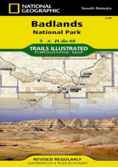
<strong>Badlands</strong> <strong>National</strong> <strong>Park</strong>: <strong>South</strong> <strong>Dakota</strong>, <strong>USA</strong> <strong>Outdoor</strong> <strong>Recreation</strong> <strong>Map</strong> (<strong>National</strong> <strong>Geographic</strong> <strong>Map</strong>s: <strong>Trails</strong> I (<strong>National</strong> <strong>Geographic</strong> <strong>Map</strong>s - <strong>Trails</strong> Illustrated) • Waterproof • Tear-Resistant • Topographic <strong>Map</strong><strong>National</strong> <strong>Geographic</strong>’s <strong>Trails</strong> Illustrated map of <strong>Badlands</strong> <strong>National</strong> <strong>Park</strong> is a comprehensive guide for outdoor enthusiasts looking to enjoy the countless outdoor adventures the park offers. Expertly researched and created in cooperation with the <strong>National</strong> <strong>Park</strong> Service, and others, the map covers the park including the Palmer Creek Area, <strong>Badlands</strong> Wilderness Area, Buffalo Gap <strong>National</strong> Grassland, and Pine Ridge Indian Reservation. An inset map of the Cedar Pass area provides additional detail of this most visited section of the park along with its seven hiking trails. Trail descriptions are also provided along with their distances.The the park s northern unit can by explored by following the <strong>Badlands</strong> Loop Road, which is shown along with its overlooks, parking and picnic areas, restrooms and other facilities. Explore the park s southern unit by following the mapped high-clearance and four-wheel-drive roads in the the backcountry. To aid in your navigation of the area, the map includes, contour lines with elevations, water features, selected waypoints and color-coded boundaries between park land, wilderness areas and Indian reservation land. Other pinpointed features<br />
include ranger stations, campgrounds and primitive campsites, and interpretive trails. Also included are a park overview, camping and hiking information, backcountry guidelines and regulations, and contact information. Every <strong>Trails</strong> Illustrated map is printed on "Backcountry Tough" waterproof, tear-resistant paper. A full UTM grid is printed on the map to aid with GPS navigation.Other features found on this map include: <strong>Badlands</strong> <strong>National</strong> <strong>Park</strong>, Cedar Butte.<strong>Map</strong> Scale = 1:55,000Sheet Size = 37.75" x 25.5"Folded Size = 4.25" x 9.25"<br />
<strong>Badlands</strong> <strong>National</strong> <strong>Park</strong>: <strong>South</strong> <strong>Dakota</strong>, <strong>USA</strong> <strong>Outdoor</strong><br />
<strong>Recreation</strong> <strong>Map</strong> (<strong>National</strong> <strong>Geographic</strong> <strong>Map</strong>s: <strong>Trails</strong> I
Product details<br />
● Author : <strong>National</strong> <strong>Geographic</strong> <strong>Map</strong>s - <strong>Trails</strong><br />
Illustrated<br />
●<br />
Pages : 2 pages<br />
● Publisher : <strong>National</strong> <strong>Geographic</strong> <strong>Map</strong>s 2008-<br />
01-01<br />
●<br />
●<br />
●<br />
Language : English<br />
ISBN-10 : 1566954088<br />
ISBN-13 : 9781566954082
<strong>Badlands</strong> <strong>National</strong> <strong>Park</strong>: <strong>South</strong> <strong>Dakota</strong>, <strong>USA</strong><br />
<strong>Outdoor</strong> <strong>Recreation</strong> <strong>Map</strong> (<strong>National</strong> <strong>Geographic</strong><br />
<strong>Map</strong>s: <strong>Trails</strong> I


![Central America [Map Pack Bundle] (National Geographic Adventure Map)](https://img.yumpu.com/59274952/1/184x260/central-america-map-pack-bundle-national-geographic-adventure-map.jpg?quality=85)