

Death Valley National Park (National Geographic Trails Illustrated Map)
Death Valley National Park (National Geographic Trails Illustrated Map)
Death Valley National Park (National Geographic Trails Illustrated Map)

Create successful ePaper yourself
Turn your PDF publications into a flip-book with our unique Google optimized e-Paper software.
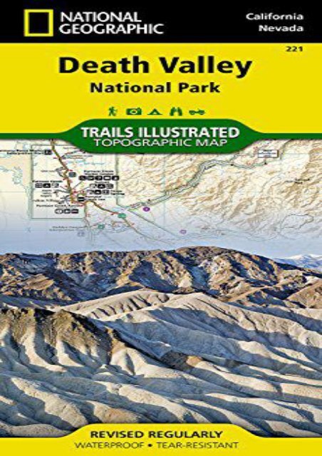
<strong>Death</strong> <strong>Valley</strong> <strong>National</strong> <strong>Park</strong> (<strong>National</strong> <strong>Geographic</strong> <strong>Trails</strong> <strong>Illustrated</strong> <strong>Map</strong>) (<strong>National</strong> <strong>Geographic</strong> <strong>Map</strong>s - <strong>Trails</strong> <strong>Illustrated</strong>) • Waterproof • Tear-Resistant • Topographic <strong>Map</strong>Despite its foreboding name and the fact that it is the hottest, lowest, and driest area in North America, <strong>Death</strong> <strong>Valley</strong> <strong>National</strong> <strong>Park</strong> maintains a great diversity of life in its dramatic terrain of salt-flats, canyons, mountains, valleys, sand dunes, and badlands. <strong>National</strong> <strong>Geographic</strong>’s <strong>Trails</strong> <strong>Illustrated</strong> map of <strong>Death</strong> <strong>Valley</strong> <strong>National</strong> <strong>Park</strong> delivers unmatched detail and valuable information to assist you in your visit to this land of extremes. Expertly researched and created in partnership with local land management agencies, this map features key areas of interest including Badwater Basin, Furnace Creek, Scotty’s Castle, Panamint Springs, and Stovepipe Wells.With miles of clearly marked trails that include mileages between intersections, this map will prove invaluable in your exploration of the park. A list of backcountry roads and trails complete with descriptions, lengths, and starting points will help you choose a route that’s right for your activity level and recreation use. The map base includes contour lines and elevations for summits. Hot weather tips, a temperature chart, regulations, and safety suggestions are included as well.Every <strong>Trails</strong> <strong>Illustrated</strong> map is printed on "Backcountry Tough" waterproof,<br />
tear-resistant paper. A full UTM grid is printed on the map to aid with GPS navigation.Other features found on this map include: Amargosa Desert, Amargosa River, Badwater Basin, Bare Mountain, Black Mountains, Cottonwood Mountains, <strong>Death</strong> <strong>Valley</strong>, Eureka <strong>Valley</strong>, Funeral Mountains, Gold Mountain, Grapevine Mountains, Greenwater Range, Inyo Mountains, Inyo Mountains Wilderness, Inyo <strong>National</strong> Forest, Last Chance Mountain, Nelson Range, New York Butte, Owens Lake, Owens River, Owlshead Mountains, Panamint Range, Saline <strong>Valley</strong>, Sarcobatus Flat, Searles Lake, Telescope Peak, Towne Pass, Tucki Mountain, Ubehebe Peak.<strong>Map</strong> Scale = 1:165,000Sheet Size = 37.75" x 25.5"Folded Size = 4.25" x 9.25"<br />
<strong>Death</strong> <strong>Valley</strong> <strong>National</strong> <strong>Park</strong> (<strong>National</strong> <strong>Geographic</strong> <strong>Trails</strong><br />
<strong>Illustrated</strong> <strong>Map</strong>)
●<br />
Author : <strong>National</strong> <strong>Geographic</strong> <strong>Map</strong>s - <strong>Trails</strong> <strong>Illustrated</strong><br />
●<br />
●<br />
●<br />
●<br />
●<br />
Pages : 2 pages<br />
Publisher : <strong>National</strong> <strong>Geographic</strong> <strong>Map</strong>s 2014-01-01<br />
Language : English<br />
ISBN-10 : 1566953219<br />
ISBN-13 : 9781566953214
<strong>Death</strong> <strong>Valley</strong> <strong>National</strong> <strong>Park</strong> (<strong>National</strong> <strong>Geographic</strong><br />
<strong>Trails</strong> <strong>Illustrated</strong> <strong>Map</strong>)


![World Decorator [Enlarged and Laminated] (National Geographic Reference Map)](https://img.yumpu.com/59273647/1/184x260/world-decorator-enlarged-and-laminated-national-geographic-reference-map.jpg?quality=85)
![Absaroka-Beartooth Wilderness East [Cooke City, Red Lodge] (National Geographic Trails Illustrated Map)](https://img.yumpu.com/59273645/1/184x260/absaroka-beartooth-wilderness-east-cooke-city-red-lodge-national-geographic-trails-illustrated-map.jpg?quality=85)
