chapter - Atmospheric and Oceanic Science
chapter - Atmospheric and Oceanic Science
chapter - Atmospheric and Oceanic Science

You also want an ePaper? Increase the reach of your titles
YUMPU automatically turns print PDFs into web optimized ePapers that Google loves.
The Chaco is the second biome in extension of South America. It corresponds<br />
to an alluvional area that is located East from the Andes mountain range, formed by<br />
the deposit of sediments, mainly from the Bermejo <strong>and</strong> Pilcomayo rivers. Since the<br />
Bermejo is the only river whose waters starts at the Andes <strong>and</strong> reaches the Paraguay<br />
River, it constitutes a natural ecological corridor among the puna ecosystems in the<br />
mountain, the yungas forest <strong>and</strong> the dry <strong>and</strong> humid areas of El Chaco plains.<br />
The Pampas's plain, due to their dimensions, is the third ecosystem of global<br />
importance. The most fertile soils in the La Plata basin are located in these plains<br />
<strong>and</strong> since long ago the agricultural production has settled in the area.<br />
The territory of the basin is completed by other key ecosystems of South<br />
America: the Cerrado, to the North, of a wide biological diversity <strong>and</strong> the Mata<br />
Atlantica, to the Northeast, at present characterized mainly by a strong deforestation<br />
of their original forests that have been reduced to 4% of its primary state.<br />
These data indicate the abundance <strong>and</strong> quality of the natural resources <strong>and</strong> the<br />
natural productivity, goods <strong>and</strong> services that these ecosystems provide. They also<br />
show how significant it has been <strong>and</strong> it's still being the availability, both in quality<br />
<strong>and</strong> quantity, of their water resources for the sustainability of the development<br />
process of the region.<br />
4.4. Characteristics of the sub-basins<br />
Physiography <strong>and</strong> Hydrology<br />
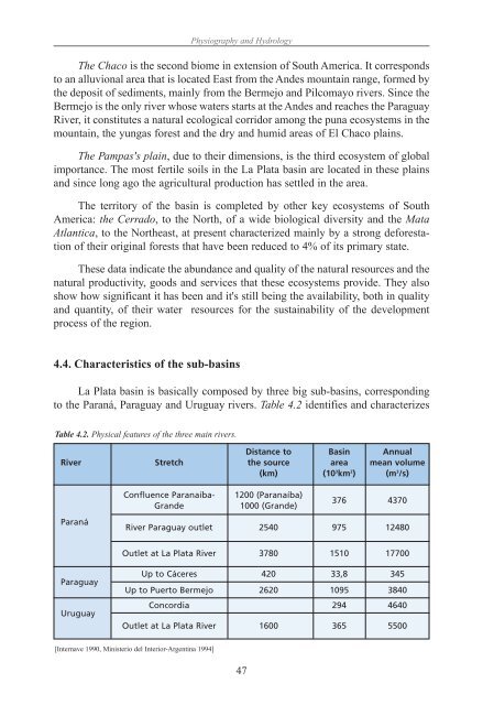
La Plata basin is basically composed by three big sub-basins, corresponding<br />
to the Paraná, Paraguay <strong>and</strong> Uruguay rivers. Table 4.2 identifies <strong>and</strong> characterizes<br />
Table 4.2. Physical features of the three main rivers.<br />
Distance to Basin Annual<br />
River Stretch the source area mean volume<br />
(km) (10 3 km 2 ) (m 3 /s)<br />
Paraná<br />
Paraguay<br />
Uruguay<br />
Confluence Paranaíba- 1200 (Paranaíba)<br />
Gr<strong>and</strong>e 1000 (Gr<strong>and</strong>e)<br />
47<br />
376 4370<br />
River Paraguay outlet 2540 975 12480<br />
Outlet at La Plata River 3780 1510 17700<br />
Up to Cáceres 420 33,8 345<br />
Up to Puerto Bermejo 2620 1095 3840<br />
Concordia 294 4640<br />
Outlet at La Plata River 1600 365 5500<br />
[Internave 1990, Ministerio del Interior-Argentina 1994]