Middle Rio Grande Regional Water Plan
2iUWd5b 2iUWd5b
Snowpack is an indicator of potential streamflow trends, but no Natural Resources Conservation Service (NRCS) SNOTEL or snow course stations are located in the planning region. Snow depth and snow water equivalent data are collected by the NRCS (2014a) at stations north of the region, and these data are used by water managers in the Middle Rio Grande region to anticipate spring snowmelt. The snow water equivalent is the amount of water, reported in inches, within the snowpack, or the amount of water that would result if the snowpack were instantly melted (NRCS, 2014b). The end of season snowpack is a good indicator of the runoff that will be available to meet water supply needs. Another way to review long-term variations in climate conditions is through drought indices. A drought index consists of a ranking system derived from the assimilation of data—including rainfall, snowpack, streamflow, and other water supply indicators—for a given region. The Palmer Drought Severity Index (PDSI) was created by W.C. Palmer (1965) to measure the variations in the moisture supply and is calculated using precipitation and temperature data as well as the available water content of the soil. Because it provides a standard measure that allows comparisons among different locations and months, the index is widely used to assess the weather during any time period relative to historical conditions. The PDSI classifications for dry to wet periods are provided in Table 5-3. Table 5-3. Palmer Drought Severity Index Classifications PDSI Classification Description + 4.00 or more Extremely wet +3.00 to +3.99 Very wet +2.00 to +2.99 Moderately wet +1.00 to +1.99 Slightly wet +0.50 to +0.99 Incipient wet spell +0.49 to –0.49 Near normal –0.50 to –0.99 Incipient dry spell –1.00 to –1.99 Mild drought –2.00 to –2.99 Moderate drought –3.00 to –3.99 Severe drought –4.00 or less Extreme drought There are considerable limitations when using the PDSI, as it may not describe rainfall and runoff that varies from location to location within a climate division and may also lag in indicating emerging droughts by several months. Also, the PDSI does not consider groundwater or reservoir storage, which can affect the availability of water supplies during drought conditions. However, even with its limitations, many states incorporate the PDSI into their Middle Rio Grande Regional Water Plan 2017 72
drought monitoring systems, and it provides a good indication of long-term relative variations in drought conditions, as PDSI records are available for more than 100 years. The PDSI is calculated for climate divisions throughout the United States. The Middle Rio Grande region falls within five New Mexico Climate Divisions (1, 2, 4, 5, and 6), though only a very small part of Division 1, located in the northwest corner of the region (Figure 5-1). The chronological history of drought, as illustrated by the PDSI for Climate Divisions 2, 4, 5, and 6, indicates that the most severe droughts in the last century occurred in the early 1900s, the 1950s, the early 2000s, and in recent years (2011 to 2013) (Figure 5-6a and 5-6b). The 2004 RWP referenced a long-term tree ring study (Grissino-Mayer, 1996) which indicates that recent precipitation at the time the plan was prepared was higher than the long-term average and that extrapolation for the future from water budget data may yield an overly optimistic picture. The likelihood of drought conditions developing in New Mexico is influenced by several weather patterns: • El Niño/La Niña: El Niño and La Niña are characterized by a periodic warming and cooling, respectively, of sea surface temperatures across the central and east-central equatorial Pacific. Years in which El Niño is present are more likely to be wetter than average in New Mexico, and years with La Niña conditions are more likely to be drier than average, particularly during the cool seasons of winter and spring. • The Pacific Decadal Oscillation (PDO): The PDO is a multi-decadal pattern of climate variability caused by shifting sea surface temperatures between the eastern and western Pacific Ocean that cycle approximately every 20 to 30 years. Warm phases of the PDO (shown as positive numbers on the PDO index) correspond to El Niño-like temperature and precipitation anomalies (i.e., wetter than average), while cool phases of the PDO (shown as negative numbers on the PDO index) correspond to La Niña-like climate patterns (drier than average). It is believed that since 1999 the planning region has been in the cool phase of the PDO. • The Atlantic Multidecadal Oscillation (AMO): The AMO refers to variations in surface temperatures of the Atlantic Ocean which, similarly to the PDO, cycle on a multi-decade frequency. The pairing of a cool phase of the PDO with the warm phase of the AMO is typical of drought in the southwestern United States (McCabe et al., 2004; Stewart, 2009). The AMO has been in a warm phase since 1995. It is possible that the AMO may be shifting to a cool phase but the data are not yet conclusive. Middle Rio Grande Regional Water Plan 2017 73
- Page 43 and 44: Table 3-1. Summary of Demographic a
- Page 45 and 46: 4. Legal Issues 4.1 Relevant Water
- Page 47 and 48: In addition to Tri-State, several c
- Page 49 and 50: Socorro, Valencia, Bernalillo, Sand
- Page 51 and 52: Authority’s application sought to
- Page 53 and 54: equires the NMOSE to conduct hydrol
- Page 55 and 56: 3. Allow for the declaration of dom
- Page 57 and 58: provided for another review procedu
- Page 59 and 60: Source: NMOSE, 2014a and 2014c La J
- Page 61 and 62: 4.1.3 Federal Water Laws The law of
- Page 63 and 64: As discussed above, the three party
- Page 65 and 66: existing, and future uses). No adju
- Page 67 and 68: • Gather information on domestic
- Page 69 and 70: plan recognizes that water is easil
- Page 71 and 72: • Protect groundwater by preventi
- Page 73 and 74: not adequately consider all of the
- Page 75 and 76: 4.2.2 Water Quality Laws 4.2.2.1 Fe
- Page 77 and 78: National Priorities List (NPL). 42
- Page 79 and 80: • The Jicarilla Apache Nation Cod
- Page 81 and 82: • Water users seeking to obtain w
- Page 83 and 84: • The Federal Emergency Managemen
- Page 85 and 86: water balance in the Middle Rio Gra
- Page 87 and 88: Table 5-1. Middle Rio Grande Climat
- Page 89 and 90: Sources: 1. WRCC, 2014 2. NWS, 2005
- Page 91 and 92: Jemez Springs Temperature (°F) 90
- Page 93: Jemez Springs Precipitation (inches
- Page 97 and 98: Climate Division 5 14 12 10 8 6 4 2
- Page 99 and 100: expected. To assess climate trends
- Page 101 and 102: Rio Chama La Jara JEMEZ RIVER NEAR
- Page 103 and 104: Table 5-4a. USGS Stream Gage Statio
- Page 105 and 106: Table 5-4a. USGS Stream Gage Statio
- Page 107 and 108: Table 5-4b. USGS Stream Gage Annual
- Page 109 and 110: Table 5-5. USGS Stream Gage Average
- Page 111 and 112: 1,200,000 1,000,000 Jemez River nea
- Page 113 and 114: Rio Grande at Albuquerque, NM 2,000
- Page 115 and 116: Table 5-6. Reservoirs and Lakes (gr
- Page 117 and 118: Table 5-7. Dams with Dam Safety Def
- Page 119 and 120: Tsj Southern Rocky Mountain Colorad
- Page 121 and 122: In order to evaluate changes in wat
- Page 123 and 124: 5,025 5,020 351852106344901 Aquifer
- Page 125 and 126: Source: NMED, 2014a and 2014c Note:
- Page 127 and 128: Table 5-8. Total Maximum Daily Load
- Page 129 and 130: Table 5-8. Total Maximum Daily Load
- Page 131 and 132: Table 5-8. Total Maximum Daily Load
- Page 133 and 134: Table 5-8. Total Maximum Daily Load
- Page 135 and 136: Table 5-8. Total Maximum Daily Load
- Page 137 and 138: Table 5-9. Municipal and Industrial
- Page 139 and 140: Table 5-10. Groundwater Discharge P
- Page 141 and 142: Table 5-10. Groundwater Discharge P
- Page 143 and 144: Table 5-10. Groundwater Discharge P
Snowpack is an indicator of potential streamflow trends, but no Natural Resources Conservation<br />
Service (NRCS) SNOTEL or snow course stations are located in the planning region. Snow<br />
depth and snow water equivalent data are collected by the NRCS (2014a) at stations north of the<br />
region, and these data are used by water managers in the <strong>Middle</strong> <strong>Rio</strong> <strong>Grande</strong> region to anticipate<br />
spring snowmelt. The snow water equivalent is the amount of water, reported in inches, within<br />
the snowpack, or the amount of water that would result if the snowpack were instantly melted<br />
(NRCS, 2014b). The end of season snowpack is a good indicator of the runoff that will be<br />
available to meet water supply needs.<br />
Another way to review long-term variations in climate conditions is through drought indices. A<br />
drought index consists of a ranking system derived from the assimilation of data—including<br />
rainfall, snowpack, streamflow, and other water supply indicators—for a given region. The<br />
Palmer Drought Severity Index (PDSI) was created by W.C. Palmer (1965) to measure the<br />
variations in the moisture supply and is calculated using precipitation and temperature data as<br />
well as the available water content of the soil. Because it provides a standard measure that<br />
allows comparisons among different locations and months, the index is widely used to assess the<br />
weather during any time period relative to historical conditions. The PDSI classifications for dry<br />
to wet periods are provided in Table 5-3.<br />
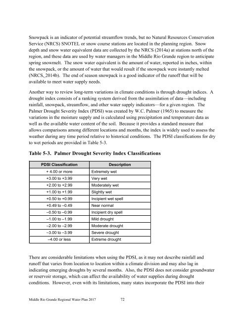
Table 5-3. Palmer Drought Severity Index Classifications<br />
PDSI Classification<br />
Description<br />
+ 4.00 or more Extremely wet<br />
+3.00 to +3.99 Very wet<br />
+2.00 to +2.99 Moderately wet<br />
+1.00 to +1.99 Slightly wet<br />
+0.50 to +0.99 Incipient wet spell<br />
+0.49 to –0.49 Near normal<br />
–0.50 to –0.99 Incipient dry spell<br />
–1.00 to –1.99 Mild drought<br />
–2.00 to –2.99 Moderate drought<br />
–3.00 to –3.99 Severe drought<br />
–4.00 or less Extreme drought<br />
There are considerable limitations when using the PDSI, as it may not describe rainfall and<br />
runoff that varies from location to location within a climate division and may also lag in<br />
indicating emerging droughts by several months. Also, the PDSI does not consider groundwater<br />
or reservoir storage, which can affect the availability of water supplies during drought<br />
conditions. However, even with its limitations, many states incorporate the PDSI into their<br />
<strong>Middle</strong> <strong>Rio</strong> <strong>Grande</strong> <strong>Regional</strong> <strong>Water</strong> <strong>Plan</strong> 2017 72


