GEOmedia_3_2016 special issue for INTERGEO

You also want an ePaper? Increase the reach of your titles
YUMPU automatically turns print PDFs into web optimized ePapers that Google loves.
<strong>INTERGEO</strong><br />
ers, which operated in staticrapid<br />
mode, were connected via<br />
Internet to NetGeo <strong>for</strong> a fine<br />
RTK positioning in the Italian<br />
reference system (ETRF 2000).<br />
The set of direct geo-referenced<br />
scanning stations also provided<br />
a pseudo GNSS network, able<br />
to act as a geodetic support.<br />
The collected point clouds were<br />
altogether 200, with an average<br />
spatial resolution of 100 mm in<br />
the useful range (10÷350) m;<br />
the computer storage has been<br />
globally around 26 GB.<br />
S. Pellegrino Terme, a small<br />
tourist settlement today, was<br />
very fashionable last century<br />
in the world of entrepreneurial<br />
bourgeoisie. The town is located<br />
along the narrow Brembo<br />
valley (north of the city of<br />
Bergamo): famous <strong>for</strong> the healing<br />
waters, it stands out in the<br />
local landscape with the undisputed<br />
charm of its architectures<br />
and the elegance of the urban<br />
environment.<br />
Among the artistic treasures,<br />
it must be remembered the<br />
municipal Club-House (1904-<br />
1906), with two towers reminiscent<br />
of the famous one in<br />
Monte Carlo (Principality of<br />
Monaco), and the impressive<br />
Grand Hotel (1904), along the<br />
Brembo river, with the large<br />
front full of decorations.<br />
The Grand Hotel is connected<br />
to the Club-House and the Spa<br />
buildings, located on the right<br />
bank of the river, through the<br />
bridge “Principe Umberto I”.<br />
All these structures were realized<br />
at the beginning of the<br />
nineteenth century in the<br />
years of Belle Époque and Art<br />
Nouveau.<br />
The terrestrial scanning survey<br />
was per<strong>for</strong>med in a multi-level<br />
detail, ranging from OGC-<br />
LoD2 and OGC-LoD4, and<br />
corresponding to the scales<br />
from 1:500 to 1:100.<br />
A Faro laser scanner (Focus<br />
X330) was utilized, with a builtin<br />
photo-camera; this scanner,<br />
characterized by a long range<br />
(around 350 m), is particularly<br />
effective <strong>for</strong> 3D survey of large<br />
territorial spaces because it allows<br />
a meaningful reduction<br />
of the instrumental stations<br />
needed to capture in<strong>for</strong>mation<br />
(see figures 3, 4, 5, 6).<br />
Good results were generally<br />
obtained, despite some deficiencies<br />
in the building-roof<br />
documentation, thanks to the<br />
favorable hilly morphology and<br />
the large range provided by the<br />
scanning device.<br />
The roof knowledge could be<br />
better realized through an additional<br />
survey from above, using<br />
UAS techniques.<br />
The other experience:<br />
the UAS survey of the<br />
Dehonian complex<br />
The religious complex of<br />
Dehonian fathers, is located in<br />
Albino, a small town in the valley<br />
of Serio, the river flowing<br />
down from the mountains surrounding<br />
Bergamo.<br />
This Apostolic school was<br />
built in 1910; during the years<br />
of World War II it became a<br />
kind of big ark hosting people<br />
evacuated from their homes<br />
and moved to Albino, which<br />
was considered safer from the<br />
bombing risk.<br />
In 1944 a part of the complex<br />
was occupied by the Italian military,<br />
who remained there until<br />
early 1945; during the war, the<br />
little town was bombed but the<br />
Apostolic school was luckily<br />
spared.<br />
In the following years, until<br />
1991, the structure served as<br />
Diocesan Seminary; when this<br />
activity ceased, the complex of<br />
buildings was renovated to create<br />
a meeting point <strong>for</strong> spirituality<br />
(fig. 7), still active.<br />
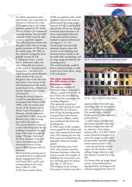
The imaging survey (using a<br />
hexa-copter) aimed to provide a<br />
Fig. 8a – The flight planning <strong>for</strong> the nadir image coverage.<br />
Fig. 8b – Vertical strips with oblique images.<br />
spatial model of the built area,<br />
including roofs, <strong>for</strong> documentation<br />
and maintenance purposes.<br />
The model, with a level of<br />
detail equal to 1:200 scale, was<br />
per<strong>for</strong>med by:<br />
- a nadir image coverage with<br />
horizontal (parallel) strips (fig.<br />
8a) from heights less than 50<br />
m, taken by a Sony photocamera<br />
with a 14.2 MP CMOS<br />
sensor (fixed focal length of 16<br />
mm); the image overlaps were<br />
between 80% and 60% and the<br />
carrier speed around 5 m/s.<br />
- some up and down vertical<br />
strips over the façades, with<br />
oblique images taken at a surface<br />
distance around 10 m (fig.<br />
8b).<br />
It is known that an image-based<br />
survey can be per<strong>for</strong>med using<br />
algorithms, techniques and<br />
software ranging from those of<br />
Special Supplement to <strong>GEOmedia</strong> Journal Issue n°3-<strong>2016</strong> 19