GEOmedia_3_2016 special issue for INTERGEO
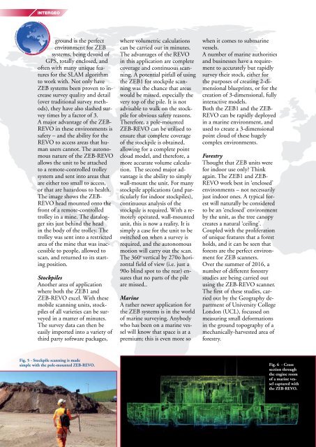
INTERGEO ground is the perfect environment for ZEB systems, being devoid of GPS, totally enclosed, and often with many unique features for the SLAM algorithm to work with. Not only have ZEB systems been proven to increase survey quality and detail (over traditional survey methods), they have also slashed survey times by a factor of 3. A major advantage of the ZEB- REVO in these environments is safety – and the ability for the REVO to access areas that human users cannot. The autonomous nature of the ZEB-REVO allows the unit to be attached to a remote-controlled trolley system and sent into areas that are either too small to access, or that are hazardous to health. The image shows the ZEB- REVO head mounted onto the front of a remote-controlled trolley in a mine. The datalogger sits just behind the head in the body of the trolley. The trolley was sent into a restricted area of the mine that was inaccessible to people, allowed to scan, and returned to its starting position. Stockpiles Another area of application where both the ZEB1 and ZEB-REVO excel. With these mobile scanning units, stockpiles of all varieties can be surveyed in a matter of minutes. The survey data can then be easily imported into a variety of third party software packages, where volumetric calculations can be carried out in minutes. The advantages of the REVO in this application are complete coverage and continuous scanning. A potential pitfall of using the ZEB1 for stockpile scanning was the chance that areas would be missed, especially the very top of the pile. It is not advisable to walk on the stockpile for obvious safety reasons. Therefore, a pole-mounted ZEB-REVO can be utilised to ensure that complete coverage of the stockpile is obtained, allowing for a complete point cloud model, and therefore, a more accurate volume calculation. The second major advantage is the ability to simply wall-mount the unit. For many stockpile applications (and particularly for indoor stockpiles), continuous analysis of the stockpile is required. With a remotely operated, wall-mounted unit, this is now a reality. It is simply a case for the unit to be switched on when a survey is required, and the autonomous motion will carry out the scan. The 360 o vertical by 270o horizontal field of view (i.e. just a 90o blind spot to the rear) ensures that no parts of the pile are missed.. Marine A rather newer application for the ZEB systems is in the world of marine surveying. Anybody who has been on a marine vessel will know that space is at a premium; this is even more so when it comes to submarine vessels. A number of marine authorities and businesses have a requirement to accurately but rapidly survey their stock, either for the purposes of creating 2-dimensional blueprints, or for the creation of 3-dimensional, fully interactive models. Both the ZEB1 and the ZEB- REVO can be rapidly deployed in a marine environment, and used to create a 3-dimensional point cloud of these hugely complex environments. Forestry Thought that ZEB units were for indoor use only? Think again. The ZEB1 and ZEB- REVO work best in ‘enclosed’ environments – not necessarily just indoor ones. A typical forest will naturally be considered to be an ‘enclosed’ environment by the unit, as the tree canopy creates a natural ‘ceiling’. Coupled with the proliferation of unique features that a forest holds, and it can be seen that forests are the perfect environment for ZEB scanners. Over the summer of 2016, a number of different forestry studies are being carried out using the ZEB-REVO scanner. The first of these studies, carried out by the Geography department of University College London (UCL), focussed on measuring small deformations in the ground topography of a mechanically-harvested area of forestry. Fig. 5 - Stockpile scanning is made simple with the pole-mounted ZEB-REVO. Fig. 6 - Cross section through the engine room of a marine vessel captured with the ZEB-REVO. 24 Special Supplement to GEOmedia Journal Issue n. 3-2016
INTERGEO Fig. 7 - 3D data of a vehicle captured with the ZEB-REVO in minutes. The suspicious package is highlighted red. From the data collected, the team were able to create a cmaccurate digital elevation model (DEM) spanning 100s of square metres. This data is then being used to measure the outputs of methane (CH 4 ) from these areas of felled forestry. Another study, conducted in relation with the University of Leicester, involves the mapping of varying forestry habitats across the UK. The aim of this study is to make comparisons between different forestry habitats across the UK, and also to combine the data captured with the handheld ZEB-REVO with data captured from above, using spaceborne-rader and UAVbased imagery. On a simpler note, both ZEB units can be utilised to rapidly and accurately scan an area of forestry, to obtain the point cloud data, and to make cuts or sections in the data at certain heights. One such important height is the breast height diameter (BHD), which is a measurement taken at 4.5 foot from the ground. This measurement is then used to create an estimate for the biomass of the area of forestry in question. Security and Contingency Mapping A final and possibly unexpected use for both ZEB units is in the ever-growing realm of security. In an increasingly uncertain world, governments, police forces, security agencies and indeed even companies are increasingly security-conscious and are turning to new technologies to increase their security. ZEB1 units have been in use by a number of police forces since their launch in 2013. Their speed, ease of use and high mobility make them the perfect tool for capturing the details of a crime scene, accident scene, or for mapping a building or site of interest. In the case where speed is of the essence (for example, after a RTC on a major road) the ZEB unit can be deployed in seconds, with a scan complete in a few minutes. This allows for a fully 3 dimensional image, accurate to within a few centimetres, to be gained. The development of the autonomous ZEB-REVO has obvious benefits in these areas. In the case of a crime scene, the polemounted ZEB-REVO may be deployed, to ensure that areas of interest are not touched or disturbed. Where there is a risk to human health (for example, a bomb threat, or an unsecure building), the REVO can be trolley mounted (as in mining) and sent in alone to scan the area of interest. It is our prediction that the realms of security and reconnaissance, there will be increasing demand for this type of rapid, mobile, versatile surveying tools. The Future So what does the future hold for GeoSLAM? In a rapidly growing, rapidly changing industry, standing still is quite simply not an option. GeoSLAM will continue to respond to new challenges, new technological developments, and to identify new areas of application. Be sure to pay attention to forthcoming GeoSLAM announcements, to hear more about these highly exciting developments in the pipeline. KEYWORDS GeoSLAM; ZEB-REVO; scan ABSTRACT GeoSLAM is a manufacturer and supplier of handheld, 3D mobile mapping systems. Founded in 2012 and headquartered in the UK, GeoSLAM now has a global distribution network of 35 distributors across six continents. AUTHOR Stuart Cadge, Pre Sales Engineer at GeoSLAM For more information, please visit www.geoslam.com info@geoslam.com Fig. 8 - Point cloud data of an area of forestry with a section taken at BHD height for biomass Special Supplement to GEOmedia Journal Issue n°3-2016 25 calculation.
- Page 1 and 2: Special Supplement to GEOmedia Jour
- Page 3 and 4: INTERGEO Fig. 2 - Direct geo-refere
- Page 5 and 6: INTERGEO ers, which operated in sta
- Page 7 and 8: INTERGEO REFERENCES B. Bhandari, U.
- Page 9: INTERGEO Fig. 3 - Building surveys
- Page 13 and 14: INTERGEO Special Supp
- Page 15 and 16: INTERGEO GIS and fire-fighting: a b
- Page 17 and 18: quite evident. Especially, it under
- Page 19 and 20: INTERGEO equipped with technology t
- Page 21 and 22: INTERGEO The aero-photogrammetric p
- Page 24: SMART GEODATA - SMART CITIES GEOSPA
<strong>INTERGEO</strong><br />
ground is the perfect<br />
environment <strong>for</strong> ZEB<br />
systems, being devoid of<br />
GPS, totally enclosed, and<br />
often with many unique features<br />
<strong>for</strong> the SLAM algorithm<br />
to work with. Not only have<br />
ZEB systems been proven to increase<br />
survey quality and detail<br />
(over traditional survey methods),<br />
they have also slashed survey<br />
times by a factor of 3.<br />
A major advantage of the ZEB-<br />
REVO in these environments is<br />
safety – and the ability <strong>for</strong> the<br />
REVO to access areas that human<br />
users cannot. The autonomous<br />
nature of the ZEB-REVO<br />
allows the unit to be attached<br />
to a remote-controlled trolley<br />
system and sent into areas that<br />
are either too small to access,<br />
or that are hazardous to health.<br />
The image shows the ZEB-<br />
REVO head mounted onto the<br />
front of a remote-controlled<br />
trolley in a mine. The datalogger<br />
sits just behind the head<br />
in the body of the trolley. The<br />
trolley was sent into a restricted<br />
area of the mine that was inaccessible<br />
to people, allowed to<br />
scan, and returned to its starting<br />
position.<br />
Stockpiles<br />
Another area of application<br />
where both the ZEB1 and<br />
ZEB-REVO excel. With these<br />
mobile scanning units, stockpiles<br />
of all varieties can be surveyed<br />
in a matter of minutes.<br />
The survey data can then be<br />
easily imported into a variety of<br />
third party software packages,<br />
where volumetric calculations<br />
can be carried out in minutes.<br />
The advantages of the REVO<br />
in this application are complete<br />
coverage and continuous scanning.<br />
A potential pitfall of using<br />
the ZEB1 <strong>for</strong> stockpile scanning<br />
was the chance that areas<br />
would be missed, e<strong>special</strong>ly the<br />
very top of the pile. It is not<br />
advisable to walk on the stockpile<br />
<strong>for</strong> obvious safety reasons.<br />
There<strong>for</strong>e, a pole-mounted<br />
ZEB-REVO can be utilised to<br />
ensure that complete coverage<br />
of the stockpile is obtained,<br />
allowing <strong>for</strong> a complete point<br />
cloud model, and there<strong>for</strong>e, a<br />
more accurate volume calculation.<br />
The second major advantage<br />
is the ability to simply<br />
wall-mount the unit. For many<br />
stockpile applications (and particularly<br />
<strong>for</strong> indoor stockpiles),<br />
continuous analysis of the<br />
stockpile is required. With a remotely<br />
operated, wall-mounted<br />
unit, this is now a reality. It is<br />
simply a case <strong>for</strong> the unit to be<br />
switched on when a survey is<br />
required, and the autonomous<br />
motion will carry out the scan.<br />
The 360 o vertical by 270o horizontal<br />
field of view (i.e. just a<br />
90o blind spot to the rear) ensures<br />
that no parts of the pile<br />
are missed..<br />
Marine<br />
A rather newer application <strong>for</strong><br />
the ZEB systems is in the world<br />
of marine surveying. Anybody<br />
who has been on a marine vessel<br />
will know that space is at a<br />
premium; this is even more so<br />
when it comes to submarine<br />
vessels.<br />
A number of marine authorities<br />
and businesses have a requirement<br />
to accurately but rapidly<br />
survey their stock, either <strong>for</strong><br />
the purposes of creating 2-dimensional<br />
blueprints, or <strong>for</strong> the<br />
creation of 3-dimensional, fully<br />
interactive models.<br />
Both the ZEB1 and the ZEB-<br />
REVO can be rapidly deployed<br />
in a marine environment, and<br />
used to create a 3-dimensional<br />
point cloud of these hugely<br />
complex environments.<br />
Forestry<br />
Thought that ZEB units were<br />
<strong>for</strong> indoor use only? Think<br />
again. The ZEB1 and ZEB-<br />
REVO work best in ‘enclosed’<br />
environments – not necessarily<br />
just indoor ones. A typical <strong>for</strong>est<br />
will naturally be considered<br />
to be an ‘enclosed’ environment<br />
by the unit, as the tree canopy<br />
creates a natural ‘ceiling’.<br />
Coupled with the proliferation<br />
of unique features that a <strong>for</strong>est<br />
holds, and it can be seen that<br />
<strong>for</strong>ests are the perfect environment<br />
<strong>for</strong> ZEB scanners.<br />
Over the summer of <strong>2016</strong>, a<br />
number of different <strong>for</strong>estry<br />
studies are being carried out<br />
using the ZEB-REVO scanner.<br />
The first of these studies, carried<br />
out by the Geography department<br />
of University College<br />
London (UCL), focussed on<br />
measuring small de<strong>for</strong>mations<br />
in the ground topography of a<br />
mechanically-harvested area of<br />
<strong>for</strong>estry.<br />
Fig. 5 - Stockpile scanning is made<br />
simple with the pole-mounted ZEB-REVO.<br />
Fig. 6 - Cross<br />
section through<br />
the engine room<br />
of a marine vessel<br />
captured with<br />
the ZEB-REVO.<br />
24 Special Supplement to <strong>GEOmedia</strong> Journal Issue n. 3-<strong>2016</strong>


