Journal of Software - Academy Publisher
Journal of Software - Academy Publisher
Journal of Software - Academy Publisher

You also want an ePaper? Increase the reach of your titles
YUMPU automatically turns print PDFs into web optimized ePapers that Google loves.
938 JOURNAL OF SOFTWARE, VOL. 6, NO. 5, MAY 2011<br />
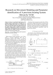
The airborne sensors for measuring terrain underneath<br />
the aircrafts are composed <strong>of</strong> barometric altimeter and<br />
radar altimeter. Fig. 1 shows the measurement procedure.<br />
The barometric altimeter measure the aircraft’s altitude<br />
above sea level while the radar altimeter gets the<br />
elevation above the ground, and the difference between<br />
the two makes the terrain elevation underneath the<br />
vehicle. During the measuring, the pressure fluctuation<br />
and atmospheric turbulence may affect the barometric<br />
altimeter while the terrain roughness and the ground<br />
vegetation may influence the radar altimeter. There are<br />
several papers discussed such error aspects [3, 4, 5]. This<br />
paper concentrates on the influence caused by the DEM<br />
error and does not introduce the sensor error components<br />
into the system model.<br />
Figure 1. Terrain elevation measurement.<br />
The basic model for terrain aided positioning is<br />
⎧ k + = k + k<br />
⎪<br />
⎨ k = k + k<br />
⎪<br />
⎩y<br />
k = h ( k ) + v<br />
* *<br />
* *<br />
e 1 e w<br />
* *<br />
x x e<br />
x<br />
where *<br />
e k is the position error <strong>of</strong> INS at time k which is<br />
modeled as time accumulated error. x k is the horizontal<br />
position from INS which is the true position<br />
k<br />
(1)<br />
*<br />
x k plus INS<br />
error *<br />
e k . y k is the terrain elevation measurement which<br />
is the true terrain elevation ( )<br />
* *<br />
h x plus the<br />
measurement noise v k . The process noise w k and<br />
measurement noise vk are independent with each other<br />
and also independent with the state *<br />
e k . They have<br />
Gaussian distribution w k ~ N(<br />
0,<br />
Qk<br />
) , v k ~ N(<br />
0,<br />
Rk<br />
) .<br />
*<br />
Due to the strong non-linearity <strong>of</strong> the terrain h ( ⋅)<br />
,<br />
this model is classified into the non-linear model and the<br />
terrain aided positioning belongs to the typical non-linear<br />
estimation problem.<br />
*<br />
In the basic model above, h ( ⋅)<br />
represents the terrain<br />
elevation map. Because the map component is denoted as<br />
© 2011 ACADEMY PUBLISHER<br />
k<br />
( )<br />
* *<br />
h x k in the measurement equation, the estimated<br />
*<br />
position x ˆ k which is corrected by the *<br />
e ˆ k through x k is<br />
*<br />
the position referenced to the map h ( ⋅)<br />
. That is to say,<br />
* *<br />
if h ( ⋅)<br />
is the real map then x ˆ k is the true position<br />
* *<br />
whereas if h ( ⋅)<br />
is the map with errors then x ˆ k is just<br />
*<br />
the position on h ( ⋅)<br />
rather than the true position. Since<br />
the real map can not be acquired, the basic model can<br />
only estimate the position referenced to the map rather<br />
the true position. Fig. 2 depicts the relationship <strong>of</strong> the<br />
values in the procedure. From the correction by the TAN,<br />
the system can give the relative position between the<br />
aircraft and the mountain and the error <strong>of</strong> that position<br />
compared to the true position is just the map error.<br />
Usually the relative position is enough for anti-collision<br />
usages. However the true position is also preferred in<br />
many occasions. So a more complicated model should be<br />
built to estimate the map error from time to time. Hence,<br />
we need to introduce the map error into the system model.<br />
Figure 2. Relationship <strong>of</strong> the values in TAN.<br />
To make the discussion simple, we assume that the<br />
map errors have the regional stability, thus they can be<br />
treated as constant parameters in a certain area.<br />
Let Δ Hk<br />
, Δ Vk<br />
be the horizontal and vertical errors<br />
<strong>of</strong> terrain elevation map respectively where Δ H k<br />
composes <strong>of</strong> two components <strong>of</strong> x and y directions. Then<br />
the TAN referenced elevation map can be expressed as<br />
*<br />
h( ) = h ( x + ΔH<br />
) + ΔV<br />
x (2)<br />
*<br />
k<br />
*<br />
k<br />
*<br />
where h ( ⋅)<br />
represents the real terrain elevation map,<br />
*<br />
x k is the real position.<br />
Let x = xk<br />
+ ΔHk<br />
*<br />
*<br />
, substitute to equation (2), we get<br />
h ( x ) = h(<br />
x − ΔHk<br />
) − ΔVk<br />
(3)<br />
Substitute (3) to the basic model (1), we get the new<br />
measurement equation using h (⋅)<br />
as<br />
y k = h(<br />
k − Δ k ) − ΔVk<br />
+ vk<br />
*<br />
x H<br />
(4)<br />
Then we can get the new system model containing the<br />
map error components:<br />
k<br />
k