Tantalum in Ethiopia
Tantalum in Ethiopia
Tantalum in Ethiopia

Create successful ePaper yourself
Turn your PDF publications into a flip-book with our unique Google optimized e-Paper software.
MINERAL RESOURCES OF<br />
<strong>Tantalum</strong> <strong>in</strong> <strong>Ethiopia</strong><br />
<strong>Tantalum</strong> is a strategic metal due<br />
to its use <strong>in</strong> one of the most widespread<br />
gadgets <strong>in</strong> modern society,<br />
the mobile phone. <strong>Tantalum</strong> is<br />
also used <strong>in</strong> other types of electronic<br />
equipment and is thus <strong>in</strong><br />
high demand. At present <strong>Ethiopia</strong><br />
supplies close to ten percent of<br />
the world consumption of tantalum<br />
and has a good potential for a<br />
considerable expansion of the<br />
production.<br />
The trade name for the most common<br />
tantalum-bear<strong>in</strong>g m<strong>in</strong>eral<br />
is ‘coltan’ whereas the m<strong>in</strong>eralogical<br />
name is colum -<br />
botantalite or columbite.<br />
The Kenticha tantalum de -<br />
posit <strong>in</strong> Southern <strong>Ethiopia</strong><br />
has Ta/Nb ratios up to 3:1,<br />
which makes the deposit<br />
economically very important.<br />
The Kenticha tantalum-be ar<strong>in</strong>g<br />
pegmatites were first discovered dur<strong>in</strong>g<br />
a geological, 1:250 000 scale, mapp<strong>in</strong>g<br />
programme carried out by <strong>Ethiopia</strong>n<br />
geologists <strong>in</strong> close co-operation with<br />
Soviet geologists <strong>in</strong> 1980. A major mapp<strong>in</strong>g<br />
and evaluation programme f<strong>in</strong>anced<br />
by the Soviet Union was carried out from<br />
1981 to 1985. The purpose of the project<br />
was to determ<strong>in</strong>e the extent of the tantalum-bear<strong>in</strong>g<br />
rocks and to evaluate their<br />
commercial potential.<br />
The Kenticha pegmatites are situated<br />
<strong>in</strong> the Adola area with<strong>in</strong> the Pre cam -<br />
brian basement of southern <strong>Ethiopia</strong>,<br />
which is the southern part of the<br />
Arabian–Nubian Shield formed by accretion<br />
of ocean arc terranes. The Neo -<br />
proterozoic rocks can be divided <strong>in</strong>to<br />
two dist<strong>in</strong>ct lithologic units:<br />
2<br />
tt bb aa rr a a<br />
Shendi<br />
Omdurmân<br />
Khartoum<br />
Kassala<br />
Abu Gamel<br />
ERITREA<br />
Keren<br />
Sebderat<br />
Adi Ugri<br />
San‘a<br />
Y E M E N<br />
Dhamar<br />
Yarim<br />
Lawdar<br />
Irqah<br />
Ash Shihr<br />
Al Mukalla<br />
Wad Medánî<br />
Om Hajer<br />
Gedaref<br />
Adwa<br />
Melau<br />
Adigrat<br />
Mek’ele<br />
Shaqra<br />
Ahwar<br />
Caluula<br />
Socotra Socot S t r ra<br />
Abd-Al-Kuri<br />
Abd-Al- A Ku K ri r<br />
The Brothers<br />
Gallabat<br />
ETHIOPIAN<br />
HIOP N<br />
Caseyr e<br />
Kosti S<strong>in</strong>ga<br />
Dabat<br />
Sek’ot’a<br />
PLATEAU<br />
PL P A TE T A U<br />
Gonder Lalibela<br />
DJIBOUTI DJIB DJIBOUTI<br />
Bender Qaasim<br />
Qandala<br />
Renk<br />
Er Roseires<br />
NUBIAN<br />
N<br />
DESERT<br />
DESE E R T<br />
Dunkur Alefa Debre Tabor<br />
Dangila Mot’a<br />
Girshit’<br />
Talo T Ta T<br />
Debre Mark’os<br />
A<br />
Debre Birhan<br />
Biye K’obe<br />
Dire Dawa<br />
Gulf of<br />
Saylac<br />
Tadjou TTadjoura adjou adjo ra r<br />
Kar<strong>in</strong><br />
Berbera<br />
Bullaxaar<br />
Shiikh<br />
Hargeysa Burao<br />
Ceerigaabo<br />
Qardho<br />
Ras Xaafuun<br />
Xaafuun<br />
Bender Beyla<br />
Nek’emte<br />
Ankober<br />
Addis Abeba<br />
Mi’eso<br />
Harer<br />
Laascaanood<br />
Eyl<br />
Dembi Dolo<br />
Koma<br />
A Nazret<br />
Degeh Bur<br />
Gore<br />
Hosa’<strong>in</strong>a<br />
Asela ETHIOPIA<br />
ETH T O<br />
O g a d e n<br />
Abera<br />
Waka<br />
G<strong>in</strong>ir<br />
Goba<br />
Batu B<br />
Megalo<br />
irga Alem<br />
e<br />
Maji<br />
Kara<br />
Gidole<br />
Burji<br />
Negele egele<br />
K’elafo<br />
El K’oran ora SOMALIA<br />
SOMALIAA<br />
Hobyo<br />
Hamer Koke<br />
Yabelo YYabelo<br />
Beled Weyne<br />
Xuddur<br />
Buulobarde<br />
Luuq<br />
Nimule<br />
Moyale<br />
Baydhabo<br />
Jawhar<br />
Lodwar<br />
Gulu<br />
U G A N D A<br />
Chalbi C h a lbi<br />
Desert Dese r t<br />
Marsabit<br />
Wajir<br />
Balcad<br />
Afgooye<br />
Uarsciek UUarsciek<br />
Baardheere<br />
Qoryooley<br />
Muqdisho<br />
(Mogadishu)<br />
Marka<br />
I N D I A N O C E A N<br />
Elgon on o<br />
K E N Y A<br />
Baraawe<br />
Afmadow<br />
Jilib<br />
lib<br />
Nanyuki<br />
Giamame GGiamame<br />
Ba B<br />
Shendi<br />
Omdurmân d<br />
Khartoum K<br />
Kassala s<br />
Abu Gamel Ga<br />
Keren<br />
Sebderat<br />
Adi Ugri<br />
San‘a<br />
Dhamar<br />
Yarim Ya<br />
im<br />
Lawdar<br />
Irqah<br />
Ash Shihr<br />
Al Mukalla<br />
Wad Medánî ed<br />
Om m Hajer<br />
Gedaref<br />
Adwa<br />
Melau M<br />
Adigrat<br />
Mek’ele<br />
Shaqra<br />
Ahwar<br />
Caluula<br />
Gallabat ab<br />
Kosti S<strong>in</strong>ga<br />
Dabat<br />
Sek’ot’a<br />
PL P A TE T<br />
Gonder G e Lalibela<br />
Bender Qaasim<br />
Qandala<br />
Renk<br />
Er Roseiress<br />
Dunkur Alefa A<br />
Debre Tabor T<br />
Dangila gi Mot’a ot’a<br />
Girshit’<br />
Debre ebre b Mark’os Mark ark’o a<br />
Debre Birhan Bi Bir Biirh<br />
Biye K’obe<br />
Dire Dawa<br />
Saylac S<br />
Kar<strong>in</strong><br />
Berbera<br />
Bullaxaar<br />
Shiikh<br />
Hargeysa Burao<br />
Ceerigaabo<br />
Qardho<br />
Xaafuun<br />
Bender Beyla<br />
Nek’emte k’<br />
Ankober<br />
Addis Abeba<br />
Mi’eso<br />
Harer H<br />
Laascaanood<br />
Eyl<br />
Dembi Dolo<br />
Koma K<br />
A Nazre Nazret<br />
Degeh Bur<br />
Gore<br />
Hosa’<strong>in</strong>a os<br />
Asela<br />
Abera Aber<br />
G<strong>in</strong>ir nir<br />
Goba<br />
Megalo<br />
Maji<br />
Kara<br />
Burji<br />
Hamer Koke<br />
Beled Weyne<br />
Nimule<br />
Gulu<br />
Gilo Gilo<br />
y y aa bb AA Setit Setit<br />
CC HH OOO KKK E EE<br />
OO mm oo<br />
• Granite-gneiss complex<br />
• Ophiolitic fold and thrust belts<br />
The ophiolitic fold and thrust belts are<br />
composed of mafic and ultramafic volcanic<br />
rocks and metasediments. After<br />
several phases of deformation and<br />
metamorphism the units were <strong>in</strong>truded<br />
by a number of pegmatites among<br />
which the Kenticha pegmatite field<br />
stands out.<br />
The Kenticha pegmatite field<br />
Pegmatites are abundant throughout<br />
the southern part of Neoproterozoic<br />
rocks <strong>in</strong> the Adola area <strong>in</strong> southernmost<br />
Abay Abayy<br />
Mt. Mt M t. Kenya Ke K ny nya Embu<br />
m y<br />
Nairobi<br />
Kitui<br />
Kajiado<br />
Awash A w ash<br />
TT ana ana<br />
Dawa Daw a<br />
ww aa ss<br />
S S NN TTT MM R R AA MM HH AA NTS S N TT MM O O BB EE DD NN EE MM Garissa<br />
A U D O R A N G E<br />
A U D O R A N G E<br />
Ganale Ganale<br />
Wabi W abi Shebele Shebele<br />
JJ uu bb bb a a<br />
andeb andeb<br />
Kismaayo<br />
GG UU LL F F OO F F AA DD EE N N<br />
Webi Webi Shabeelle<br />
Shabeelle<br />
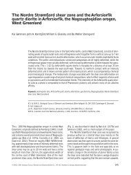
<strong>Ethiopia</strong> is located on the Horn of Africa border<strong>in</strong>g<br />
Sudan, Eritrea, Djibouti, Somalia and Kenya.<br />
<strong>Ethiopia</strong>, but are especially abundant <strong>in</strong><br />
the Kenticha pegmatite field where they<br />
occur <strong>in</strong> an area of about 2,500 km2 . The<br />
pegmatites are emplaced at or near a<br />
major NNE-SSW-trend<strong>in</strong>g shear zone.<br />
They range from barren feldspar-muscovite<br />
pegmatites to different types of<br />
rare-element pegmatites.<br />
The Ta bear<strong>in</strong>g pegmatite deposit <strong>in</strong><br />
Kenticha Field is exposed over a 2.5 km<br />
long and 40-70 m wide area. It occurs <strong>in</strong><br />
a package of steeply dipp<strong>in</strong>g serpent<strong>in</strong>ites<br />
and talc-tremolite schists. The<br />
thickness of the pegmatite varies. In<br />
locations where both hang<strong>in</strong>g and footwall<br />
contacts are exposed, thickness<br />
ranges from 40 m to 70 m.<br />
The upper part of the ore body is<br />
strongly weathered to a variety of clay<br />
m<strong>in</strong>erals. The tantalite occurs <strong>in</strong> gra<strong>in</strong> size<br />
from a few millimetres up to about 5 cm.<br />
Weather<strong>in</strong>g has affected the feldspars