STREETSCAPE GUIDANCE
streetscape-guidance streetscape-guidance
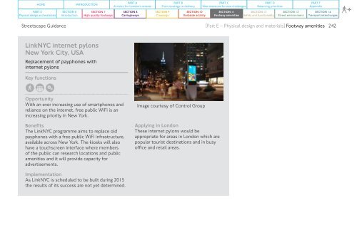
HOME PART E Physical design and materials SECTION 6 Introduction INTRODUCTION SECTION 7 High quality footways PART A A vision for London’s streets SECTION 8 Carriageways PART B From strategy to delivery SECTION 9 Crossings SECTION 10 Kerbside activity PART C New measures for new challenges SECTION 11 Footway amenities PART D Balancing priorities SECTION 12 Safety and functionality SECTION 13 Street environment PART F Appendix SECTION 14 Transport interchanges + Streetscape Guidance [Part E – Physical design and materials] Footway amenities 242 LinkNYC internet pylons New York City, USA Replacement of payphones with internet pylons Key functions Opportunity With an ever increasing use of smartphones and reliance on the internet, free public WiFi is an increasing priority in New York. Benefits The LinkNYC programme aims to replace old payphones with a free public WiFi infrastructure, available across New York. The kiosks will also have a touchscreen interface where members of the public can research locations and public amenities and it will provide capacity for advertisements. Image courtesy of Control Group Applying in London These internet pylons would be appropriate for areas in London which are popular tourist destinations and in busy office and retail areas. Implementation As LinkNYC is scheduled to be built during 2015 the results of its success are not yet determined.
HOME PART E Physical design and materials SECTION 6 Introduction INTRODUCTION SECTION 7 High quality footways PART A A vision for London’s streets SECTION 8 Carriageways PART B From strategy to delivery SECTION 9 Crossings SECTION 10 Kerbside activity PART C New measures for new challenges SECTION 11 Footway amenities PART D Balancing priorities SECTION 12 Safety and functionality SECTION 13 Street environment PART F Appendix SECTION 14 Transport interchanges + Streetscape Guidance [Part E – Physical design and materials] Footway amenities 243 11.12 Pedestrian wayfinding Vision and purpose Walking is a great way of getting around London; it is free, healthy, environmentally friendly, and often the quickest option. Yet many people are put off by inconsistent signage and confusion about distances between areas. We have developed ‘Legible London’ to tackle these issues and help residents and visitors walk to their destination quickly and easily. This awardwinning map-based system is integrated with other transport modes so when people leave the Underground, for example, they can quickly identify the route to their destination. Location Design teams should provide wayfinding guidance to aid navigation and encourage people to walk rather than seek out public transport, while aiming to minimise the total number of pedestrian signs used to reduce additional street clutter. Signs should be located where users start their journey as a pedestrian, at key decision points and landmark destinations. Signage should be located to minimise physical intrusion within the streetscape, but should be sufficiently visible so as to serve its intended purpose. Figure 242: Pedestrian wayfinding systems such as Legible London offer a consistent and recognisable system of maps across our city Where pedestrian routes cross the TLRN and are signposted using local authority signs, the signage strategy may be continued on the TLRN subject to compliance with TSRGD. Wayfinding signs do not need to be illuminated by internal or external lighting, or retroreflective materials. Legible London Since its introduction in 2007, the Legible London signage system has become the TLRN standard for pedestrian directional signage. The system provides a consistent and connected approach to the design and layout of pedestrian wayfinding across London. Scheme designers should follow a systematic approach to locating Legible London signs in the urban realm by drafting a placement strategy based on the Legible London Design Standards (2010). Figure 243: Legible London directional paving plaques
- Page 195 and 196: HOME INTRODUCTION PART A A vision f
- Page 197 and 198: HOME INTRODUCTION PART A A vision f
- Page 199 and 200: HOME INTRODUCTION PART A A vision f
- Page 201 and 202: HOME INTRODUCTION PART A A vision f
- Page 203 and 204: HOME INTRODUCTION PART A A vision f
- Page 205 and 206: HOME PART E Physical design and mat
- Page 207 and 208: HOME PART E Physical design and mat
- Page 209 and 210: HOME PART E Physical design and mat
- Page 211 and 212: HOME PART E Physical design and mat
- Page 213 and 214: HOME PART E Physical design and mat
- Page 215 and 216: HOME PART E Physical design and mat
- Page 217 and 218: HOME PART E Physical design and mat
- Page 219 and 220: HOME PART E Physical design and mat
- Page 221 and 222: HOME PART E Physical design and mat
- Page 223 and 224: HOME PART E Physical design and mat
- Page 225 and 226: HOME PART E Physical design and mat
- Page 227 and 228: HOME PART E Physical design and mat
- Page 229 and 230: HOME PART E Physical design and mat
- Page 231 and 232: HOME PART E Physical design and mat
- Page 233 and 234: HOME PART E Physical design and mat
- Page 235 and 236: HOME PART E Physical design and mat
- Page 237 and 238: HOME PART E Physical design and mat
- Page 239 and 240: HOME PART E Physical design and mat
- Page 241 and 242: HOME PART E Physical design and mat
- Page 243 and 244: HOME PART E Physical design and mat
- Page 245: HOME PART E Physical design and mat
- Page 249 and 250: HOME PART E Physical design and mat
- Page 251 and 252: HOME INTRODUCTION PART A A vision f
- Page 253 and 254: HOME INTRODUCTION PART A A vision f
- Page 255 and 256: HOME INTRODUCTION PART A A vision f
- Page 257 and 258: HOME INTRODUCTION PART A A vision f
- Page 259 and 260: HOME INTRODUCTION PART A A vision f
- Page 261 and 262: HOME INTRODUCTION PART A A vision f
- Page 263 and 264: HOME INTRODUCTION PART A A vision f
- Page 265 and 266: HOME INTRODUCTION PART A A vision f
- Page 267 and 268: HOME INTRODUCTION PART A A vision f
- Page 269 and 270: HOME INTRODUCTION PART A A vision f
- Page 271 and 272: HOME INTRODUCTION PART A A vision f
- Page 273 and 274: HOME INTRODUCTION PART A A vision f
- Page 275 and 276: HOME INTRODUCTION PART A A vision f
- Page 277 and 278: HOME INTRODUCTION PART A A vision f
- Page 279 and 280: HOME INTRODUCTION PART A A vision f
- Page 281 and 282: HOME INTRODUCTION PART A A vision f
- Page 283 and 284: HOME INTRODUCTION PART A A vision f
- Page 285 and 286: HOME INTRODUCTION PART A A vision f
- Page 287 and 288: HOME INTRODUCTION PART A A vision f
- Page 289 and 290: HOME INTRODUCTION PART A A vision f
- Page 291 and 292: HOME INTRODUCTION PART A A vision f
- Page 293 and 294: HOME INTRODUCTION PART A A vision f
- Page 295 and 296: HOME INTRODUCTION PART A A vision f
HOME<br />
PART E<br />
Physical design and materials<br />
SECTION 6<br />
Introduction<br />
INTRODUCTION<br />
SECTION 7<br />
High quality footways<br />
PART A<br />
A vision for London’s streets<br />
SECTION 8<br />
Carriageways<br />
PART B<br />
From strategy to delivery<br />
SECTION 9<br />
Crossings<br />
SECTION 10<br />
Kerbside activity<br />
PART C<br />
New measures for new challenges<br />
SECTION 11<br />
Footway amenities<br />
PART D<br />
Balancing priorities<br />
SECTION 12<br />
Safety and functionality<br />
SECTION 13<br />
Street environment<br />
PART F<br />
Appendix<br />
SECTION 14<br />
Transport interchanges<br />
+<br />
Streetscape Guidance<br />
[Part E – Physical design and materials] Footway amenities 242<br />
LinkNYC internet pylons<br />
New York City, USA<br />
Replacement of payphones with<br />
internet pylons<br />
Key functions<br />
Opportunity<br />
With an ever increasing use of smartphones and<br />
reliance on the internet, free public WiFi is an<br />
increasing priority in New York.<br />
Benefits<br />
The LinkNYC programme aims to replace old<br />
payphones with a free public WiFi infrastructure,<br />
available across New York. The kiosks will also<br />
have a touchscreen interface where members<br />
of the public can research locations and public<br />
amenities and it will provide capacity for<br />
advertisements.<br />
Image courtesy of Control Group<br />
Applying in London<br />
These internet pylons would be<br />
appropriate for areas in London which are<br />
popular tourist destinations and in busy<br />
office and retail areas.<br />
Implementation<br />
As LinkNYC is scheduled to be built during 2015<br />
the results of its success are not yet determined.


