Lava cascade in Thunderbolt Distributary of Labyrinth Cave system
report report
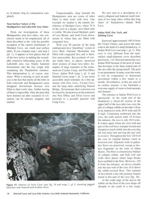
es of plaster clog its continuation completely. Near-Surface Nature of the Headquarters and Labyrinth Area Tubes From our investigations of these Headquarters area lava tubes, one conclusion needs to be emphasized: all of them described so far, with the possible exception of the eastern distributary of Mushpot Cave, are small near-surface tubes. If you compare map 1 and map 2 (pl. 1), it appears at first glance that all of the lava active in making the remarkably extensive bifurcating caves of the Labyrinth area was finally funneled downstream into the tiny single tube containing the Thunderbolt entrance. This interpretation is, of course, nonsense. What is missing in such an analysis is the fact that nearly all the tubes in both Labyrinth and Headquarters areas disappear downstream because lava filled to their roofs; thus, further tracing of them is impossible. Only the parts that have drained out after cessation of volcanism can be entered, mapped, and studied. Unquestionably, deep beneath the Headquarters area are scores of tubes filled to their roofs with lava. One example we studied is the eastern distributary of Mushpot Cave, where 70ft of the roof of a deeper, now-filled tube is visible. We also traced Mushpot, parts of Lava Brook, and Arch Caves downstream to where they are filled with congealed lava. Well over 85 percent of the deep underground lava "plumbing" system in Lava Beds National Monument was filled with congealed lava and is therefore inaccessible. But accidents of various kinds have, in places, preserved short sections of intact lava tubes. Examples of large remnants in the monument are Crystal, Craig, and Post Office Caves. Indian Well (map 1, pl. 1) and Sentinel Caves (map 7, pl. 2) are easily accessible small remnants on a line upstream with Ovis Cave, Crystal Cave, and the deep tubes underlying Natural Bridge. Downstream their extension can be traced by breakdowns at the entrances into Post Office and Silver Caves and eastward to a possible junction with Craig Cave. Figure 19. Interior of Arch Cave (see fig. 14 and map 1, pi 1) showing jagged benches and heaved and broken floor. We now tum to a description of a much collapsed and battered small remnant of two large tubes within this long chain of breakdowns-Indian Well Cave. Indian Well, Doc Yock, and Stinking Caves Eastward approximately 450 ft from the Visitor Center, and across the main road at the head of a deep breakdown, is Indian Well Cave (see map 1, pl. 1). This cave is very different from the nearsurface small-diameter caves described previously. J.D. Howard named the cave Indian Well because of the pool of water that develops in the deep central part of the cave after the spring runoff. The pool is not permanent; in many years the water is lost by evaporation or downward percolation within a few weeks to a month. Nevertheless, in this dry area of no surface streams, it has furnished a welcome supply of water to both animals and humans. The entrance to Indian Well Cave is spectacular. At the south end of the breakdown a sliced-off section of the upper half of the lava tube rises over the pile of collapse rubble on the tube's floor in an impressive arch, 60 ft wide and 20 ft high. Continuing southward into the cave, the walls narrow until, 55 ft from the entrance, the cave is only 30ft wide. It widens again where the west wall and part of the roof have slumped inward and dumped so much rubble into the cave that the trail must tum and hug the east wall to avoid it. Throughout the first 120ft of the cave no original features (such as lavacicle roof, dripstone walls or pahoehoe floor) are preserved, except as broken fragments on the ends of fallen blocks. The floor is a hummocky blanket of collapse rubble, and both roof and walls show places where large blocks have tumbled to the floor. However, 125 ft from the entrance, an alcove extends into the east wall of the cave 10 ft above the rubble-covered floor. This remnant of lava bench is the only primary feature found in this part of the cave (fig. 20). At the south edge of the alcove the rubble on the floor of the cave drops off abruptly to the south in a low scarp, 18 Selected Caves and Lava-Tube Systems, Lava Beds National Monument, California
which grades into a steep rubble slope. The trail negotiates this steep slope by stairs, which end on a platform built on the floor next to the pool basin for which the cave was named. The floor of this ephemeral pool is a smooth oval saucer 20ft long and 15ft wide. It is white from the caliche efflorescence precipitated by evaporating water. This deposit of calcium carbonate, along with clay washed down into this spot during the spring snowmelt, gives the bottom of the basin enough of an impermeable seal to hold water through part of the summer season. The pool occupies only a small part of this deep central depression, which continues 60ft farther south to where the floor rises abruptly in a steep rubble slope. How could this deep depression form at the bottom of a higher lava tube that transmitted molten lava to the north? Part of the answer becomes clear when we examine the pool basin in more detail. On the east, north, and on part of the northwestern margins of the pool is a rock lip overhanging the surface of the pool but no more than 4 ft above the bottom (see heavy dashed line on map 1, pl. 1). Apparently this is the roof of a second large tube, at a lower level. The deep depression in the central part of the upper tube was caused by its floor giving way and tumbling piecemeal through the roof of the tube below. When did this collapse happen? Evidence is equivocal, but at least a part of the collapse occurred while the lower tube was filled or nearly filled with flowing lava. Many of the collapse blocks, and all of them in the immediate area of the present water pool, apparently were carried down the tube by this flowing lava. Supporting evidence is that the caliche and clay which helped form the basin of the water pool were not deposited on an irregular heap of large fallen blocks, but they were instead deposited on a relatively flat surface. The lateral extent of this flat surface and the lavacicle roof above it can be investigated by poking a long rod between roof and floor. In several places a 15-ft stadia rod can be extended all of its length. This must mean that the lower tube is now filled almost to its roof. The blocks, which poured through this hole in the roof when the collapse occurred, did not jam but were transported down the lower tube. They were later enveloped by the ponding lava, which nearly filled the tube when it cooled. Such relations are not unusual in lava-tube caves. Clearer Figure 20. Much of original wall lining has collapsed but some remains on wall of Indian Well Cave (see fig. 14 and map 1, pl. 1). evidence of such transport can be seen in Post Office, Catacombs, Valentine, Berthas Cupboard, and many other lava-tube caves. The trail ends at the foot of the stairs, but the remaining 150 ft of accessible cave to the south is easily traversed if one does not mind climbing over large jumbled blocks. High on the west wall in this part of the cave are remnants of a balcony that runs along most of the wall, buried by slides near the middle and the south end. At the south end of the cave the floor rises higher and higher until it ends in a clutter of huge blocks not far below the surface of the ground. A small dug-open crawlway serves as an egress out into the collapse fill at the north end of the Doc Yock-Stinking Cave breakdown. In summary, Indian Well Cave is a 300-ft-long remnant of a part of two superposed large feeder tubes. Only the upper tube can be traversed. It has been so modified by rockfalls from its roof, slides through its west wall, and the collapse of 60 ft of its floor into the lower tube that almost nothing but collapse features are visible. A little of the intact roof of the lower cave can be seen in an overhang just above the floor of the water pool in the deepest part of the cave. Doc Y ock Cave is a continuation of the upper level of Indian Well Cave. As in Indian Well, the cave has undergone massive collapse with most of the resulting breakdown falling into the lower tube levels. A short intact segment of tube complete with several rafted blocks and a pahoehoe floor is present at the upper southern end of the cave. Judging from this intact segment of Doc Yock Cave, the original tube was 21 ft wide and probably in excess of 17 ft high. Stinking Cave is a further extension of the Indian Well-Doc Yock Cave tube. In cross section the 128-ft-long cave is shaped like a tall rectangular canyon, with little collapse except at the ends. The northern end lies partly underneath Dock Y ock Cave and probably represents a middle level in the tube system. It is closed by the deep collapse of the tube at the southern end of Indian Well. A short lower segment of passage just inside the entrance may represent a lower Lava-Tube Caves of the Headquarters Area 19
- Page 2 and 3: Lava cascade in Thunderbolt Distrib
- Page 4 and 5: Frontispiece. Two visitors explore
- Page 6 and 7: DEPARTMENT OF THE INTERIOR MANUEL L
- Page 8 and 9: Caves easily accessible from Cave L
- Page 10 and 11: PLATES [In pocket] 1. Caves of the
- Page 12 and 13: Many of the feature names used in t
- Page 14 and 15: Tulelake LOWER KLAMATH LAKE Prisone
- Page 16 and 17: EXPLANATION ................... Lav
- Page 18 and 19: flow, then the lava may pool behind
- Page 20 and 21: "pull outs" where the dripping plas
- Page 22 and 23: Mushpot, Catacombs, Ovis, and Merri
- Page 24 and 25: Waters agreed to do the cave mappin
- Page 26 and 27: into the distributary in the genera
- Page 28 and 29: crawled 180 ft from the Mushpot tub
- Page 32 and 33: level of the tube. The southern ent
- Page 34 and 35: surface collapse and only one comer
- Page 36 and 37: dead-end passages on different vert
- Page 38 and 39: and a roof covered with lavacicles
- Page 40 and 41: puzzles abound in the Catacombs; do
- Page 42 and 43: Ovis Cave Apparently, E.L. Hopkins
- Page 44 and 45: thus forms a bridge over the broken
- Page 46 and 47: pit is located along the southwest
- Page 48 and 49: lava tubes, and the upper parts of
- Page 50 and 51: occupies the lava pool just upstrea
- Page 52 and 53: underway. Collapse to the surface h
- Page 54 and 55: one located just below ceiling heig
- Page 56 and 57: high, but it immediately widens to
- Page 58 and 59: low depths along fissures. Many sma
- Page 60 and 61: collapse (map 9, pl. 3). Two others
- Page 62 and 63: For a short distance below the coll
- Page 64 and 65: circle the two large downstream pil
- Page 66 and 67: where it opens into the north end o
- Page 68 and 69: water well, the cave changes marked
- Page 70 and 71: the older Schonchin Butte lava flow
- Page 72 and 73: here to the entrance, the tube is f
- Page 74 and 75: One cannot walk beneath it, as unde
- Page 76 and 77: Room-is actually a natural bridge,
- Page 78 and 79: pooled in the mouth ofthe tributary
es <strong>of</strong> plaster clog its cont<strong>in</strong>uation completely.<br />
Near-Surface Nature <strong>of</strong> the<br />
Headquarters and Labyr<strong>in</strong>th Area Tubes<br />
From our <strong>in</strong>vestigations <strong>of</strong> these<br />
Headquarters area lava tubes, one conclusion<br />
needs to be emphasized: all <strong>of</strong><br />
them described so far, with the possible<br />
exception <strong>of</strong> the eastern distributary <strong>of</strong><br />
Mushpot <strong>Cave</strong>, are small near-surface<br />
tubes. If you compare map 1 and map 2<br />
(pl. 1), it appears at first glance that all<br />
<strong>of</strong> the lava active <strong>in</strong> mak<strong>in</strong>g the remarkably<br />
extensive bifurcat<strong>in</strong>g caves <strong>of</strong> the<br />
Labyr<strong>in</strong>th area was f<strong>in</strong>ally funneled<br />
downstream <strong>in</strong>to the t<strong>in</strong>y s<strong>in</strong>gle tube<br />
conta<strong>in</strong><strong>in</strong>g the <strong>Thunderbolt</strong> entrance.<br />
This <strong>in</strong>terpretation is, <strong>of</strong> course, nonsense.<br />
What is miss<strong>in</strong>g <strong>in</strong> such an analysis<br />
is the fact that nearly all the tubes <strong>in</strong><br />
both Labyr<strong>in</strong>th and Headquarters areas<br />
disappear downstream because lava<br />
filled to their ro<strong>of</strong>s; thus, further trac<strong>in</strong>g<br />
<strong>of</strong> them is impossible. Only the parts that<br />
have dra<strong>in</strong>ed out after cessation <strong>of</strong> volcanism<br />
can be entered, mapped, and<br />
studied.<br />
Unquestionably, deep beneath the<br />
Headquarters area are scores <strong>of</strong> tubes<br />
filled to their ro<strong>of</strong>s with lava. One<br />
example we studied is the eastern distributary<br />
<strong>of</strong> Mushpot <strong>Cave</strong>, where 70ft<br />
<strong>of</strong> the ro<strong>of</strong> <strong>of</strong> a deeper, now-filled tube<br />
is visible. We also traced Mushpot, parts<br />
<strong>of</strong> <strong>Lava</strong> Brook, and Arch <strong>Cave</strong>s downstream<br />
to where they are filled with<br />
congealed lava.<br />
Well over 85 percent <strong>of</strong> the deep<br />
underground lava "plumb<strong>in</strong>g" <strong>system</strong> <strong>in</strong><br />
<strong>Lava</strong> Beds National Monument was<br />
filled with congealed lava and is therefore<br />
<strong>in</strong>accessible. But accidents <strong>of</strong> various<br />
k<strong>in</strong>ds have, <strong>in</strong> places, preserved<br />
short sections <strong>of</strong> <strong>in</strong>tact lava tubes. Examples<br />
<strong>of</strong> large remnants <strong>in</strong> the monument<br />
are Crystal, Craig, and Post Office<br />
<strong>Cave</strong>s. Indian Well (map 1, pl. 1) and<br />
Sent<strong>in</strong>el <strong>Cave</strong>s (map 7, pl. 2) are easily<br />
accessible small remnants on a l<strong>in</strong>e upstream<br />
with Ovis <strong>Cave</strong>, Crystal <strong>Cave</strong>,<br />
and the deep tubes underly<strong>in</strong>g Natural<br />
Bridge. Downstream their extension can<br />
be traced by breakdowns at the entrances<br />
<strong>in</strong>to Post Office and Silver <strong>Cave</strong>s and<br />
eastward to a possible junction with<br />
Craig <strong>Cave</strong>.<br />
Figure 19. Interior <strong>of</strong> Arch <strong>Cave</strong> (see fig. 14 and map 1, pi 1) show<strong>in</strong>g jagged<br />
benches and heaved and broken floor.<br />
We now tum to a description <strong>of</strong> a<br />
much collapsed and battered small remnant<br />
<strong>of</strong> two large tubes with<strong>in</strong> this long<br />
cha<strong>in</strong> <strong>of</strong> breakdowns-Indian Well<br />
<strong>Cave</strong>.<br />
Indian Well, Doc Yock, and<br />
St<strong>in</strong>k<strong>in</strong>g <strong>Cave</strong>s<br />
Eastward approximately 450 ft from<br />
the Visitor Center, and across the ma<strong>in</strong><br />
road at the head <strong>of</strong> a deep breakdown, is<br />
Indian Well <strong>Cave</strong> (see map 1, pl. 1). This<br />
cave is very different from the nearsurface<br />
small-diameter caves described<br />
previously. J.D. Howard named the cave<br />
Indian Well because <strong>of</strong> the pool <strong>of</strong> water<br />
that develops <strong>in</strong> the deep central part <strong>of</strong><br />
the cave after the spr<strong>in</strong>g run<strong>of</strong>f. The pool<br />
is not permanent; <strong>in</strong> many years the water<br />
is lost by evaporation or downward<br />
percolation with<strong>in</strong> a few weeks to a<br />
month. Nevertheless, <strong>in</strong> this dry area <strong>of</strong><br />
no surface streams, it has furnished a<br />
welcome supply <strong>of</strong> water to both animals<br />
and humans.<br />
The entrance to Indian Well <strong>Cave</strong> is<br />
spectacular. At the south end <strong>of</strong> the<br />
breakdown a sliced-<strong>of</strong>f section <strong>of</strong> the<br />
upper half <strong>of</strong> the lava tube rises over the<br />
pile <strong>of</strong> collapse rubble on the tube's floor<br />
<strong>in</strong> an impressive arch, 60 ft wide and 20<br />
ft high. Cont<strong>in</strong>u<strong>in</strong>g southward <strong>in</strong>to the<br />
cave, the walls narrow until, 55 ft from<br />
the entrance, the cave is only 30ft wide.<br />
It widens aga<strong>in</strong> where the west wall and<br />
part <strong>of</strong> the ro<strong>of</strong> have slumped <strong>in</strong>ward and<br />
dumped so much rubble <strong>in</strong>to the cave that<br />
the trail must tum and hug the east wall<br />
to avoid it. Throughout the first 120ft <strong>of</strong><br />
the cave no orig<strong>in</strong>al features (such as<br />
lavacicle ro<strong>of</strong>, dripstone walls or pahoehoe<br />
floor) are preserved, except as broken<br />
fragments on the ends <strong>of</strong> fallen<br />
blocks. The floor is a hummocky blanket<br />
<strong>of</strong> collapse rubble, and both ro<strong>of</strong> and<br />
walls show places where large blocks<br />
have tumbled to the floor. However, 125<br />
ft from the entrance, an alcove extends<br />
<strong>in</strong>to the east wall <strong>of</strong> the cave 10 ft above<br />
the rubble-covered floor. This remnant<br />
<strong>of</strong> lava bench is the only primary feature<br />
found <strong>in</strong> this part <strong>of</strong> the cave (fig. 20).<br />
At the south edge <strong>of</strong> the alcove the<br />
rubble on the floor <strong>of</strong> the cave drops <strong>of</strong>f<br />
abruptly to the south <strong>in</strong> a low scarp,<br />
18 Selected <strong>Cave</strong>s and <strong>Lava</strong>-Tube Systems, <strong>Lava</strong> Beds National Monument, California


