

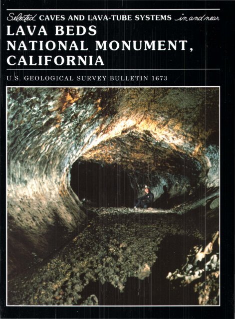
Lava cascade in Thunderbolt Distributary of Labyrinth Cave system
report
report

You also want an ePaper? Increase the reach of your titles
YUMPU automatically turns print PDFs into web optimized ePapers that Google loves.
<strong>Lava</strong> <strong>cascade</strong> <strong>in</strong> <strong>Thunderbolt</strong> <strong>Distributary</strong> <strong>of</strong> Labyr<strong>in</strong>th <strong>Cave</strong> <strong>system</strong>.
SELECTED CAVES AND LAVA-TUBE SYSTEMS<br />
IN AND NEAR LAVA BEDS<br />
NATIONAL MONUMENT, CALIFORNIA
Frontispiece. Two visitors explore Valent<strong>in</strong>e <strong>Cave</strong>, a well-preserved cave that is deservedly popular with <strong>Lava</strong> Beds National<br />
Monument visitors.
Selected <strong>Cave</strong>s and <strong>Lava</strong>-Tube Systems<br />
In and Near <strong>Lava</strong> Beds<br />
National Monument, California<br />
By AARON C. WATERS, JULIE M. DONNELLY-NOLAN, and<br />
BRUCE W. ROGERS<br />
U.S. GEOLOGICAL SURVEY BULLETIN 1673
DEPARTMENT OF THE INTERIOR<br />
MANUEL LUJAN, jR., Secretary<br />
U.S. GEOLOGICAL SURVEY<br />
Dallas L. Peck, Director<br />
Any use <strong>of</strong> trade, product, or firm names <strong>in</strong> this publication<br />
is for descriptive purposes only and does not imply<br />
endorsement by the U.S. Government<br />
UNITED STATES GOVERNMENT PRINTING OFFICE, WASHINGTON 1990<br />
For sale by the Books and Open-File Reports Section,<br />
U.S. Geological Survey, Federal Center,<br />
Box 25425, Denver, CO 80225<br />
Library <strong>of</strong> Congress Catalog<strong>in</strong>g-<strong>in</strong>-Publication Data<br />
Waters, Aaron Clement, 1905-<br />
Selected caves and lava-tube <strong>system</strong>s <strong>in</strong> and near <strong>Lava</strong> Beds<br />
National Monument, California I by Aaron C. Waters, Julie M. Donnelly-Nolan,<br />
and Bruce W. Rogers.<br />
p. em. - (U.S.Geological Survey bullet<strong>in</strong> ; 1673)<br />
Includes bibliographical references.<br />
Supt. <strong>of</strong> Docs. no.: I 19.3:1673<br />
1. <strong>Lava</strong> tubes-California-<strong>Lava</strong> Beds National Monument. 2. <strong>Cave</strong>s-California-<strong>Lava</strong><br />
Beds National Monument. 3. <strong>Lava</strong> Beds National Monument (Calif.)<br />
I. Donnelly-Nolan, Julie M. II. Rogers, Bruce W. Ill. Title. IV. Series.<br />
QE75.B9 no. 1673<br />
[GB649.L3] 557.3 s- dc20 90-3661<br />
[551.4'.0979421]<br />
CIP
CONTENTS<br />
Introduction 1<br />
Explor<strong>in</strong>g the caves 8<br />
<strong>Cave</strong> names 8<br />
<strong>Cave</strong> maps and descriptions 9<br />
Preparation <strong>of</strong> the maps 11<br />
Acknowledgments 11<br />
<strong>Cave</strong>s easily accessible from <strong>Cave</strong> Loop Road 12<br />
<strong>Lava</strong>-Tube <strong>Cave</strong>s <strong>of</strong> the Headquarters area 12<br />
Mushpot <strong>Cave</strong> 12<br />
Features near entrance 12<br />
High-lava marks 13<br />
Eastern distributary 13<br />
Western tributary 14<br />
Balconies and skylights 14<br />
Dripstone and lavacicles 14<br />
Caliche, false gold, and phosphorescent deposits 14<br />
<strong>Lava</strong> Brook <strong>Cave</strong> 15<br />
Three Junction area 15<br />
Tw<strong>in</strong> Pillars-Sleep<strong>in</strong>g Beauty area 16<br />
Mushpot-<strong>Lava</strong> Brook floor jam 16<br />
South tributary 16<br />
<strong>Lava</strong> Brook <strong>Cave</strong> upstream from entrance 16<br />
Area near <strong>Thunderbolt</strong> entrance 17<br />
<strong>Thunderbolt</strong> <strong>Distributary</strong> (East Labyr<strong>in</strong>th <strong>Cave</strong>) 17<br />
Downstream from East Labyr<strong>in</strong>th entrance 17<br />
Arch <strong>Cave</strong> 17<br />
Near-surface nature <strong>of</strong> the Headquarters and Labyr<strong>in</strong>th area tubes 18<br />
Indian Well, Doc Y ock, and St<strong>in</strong>k<strong>in</strong>g <strong>Cave</strong>s 18<br />
Labyr<strong>in</strong>th <strong>Cave</strong> System 20<br />
Garden Bridges area 20<br />
Blue Grotto area 21<br />
Hopk<strong>in</strong>s Chocolate <strong>Cave</strong> 22<br />
Golden Dome <strong>Cave</strong> 22<br />
Labyr<strong>in</strong>th (area east <strong>of</strong> Garden Bridges) 23<br />
<strong>Thunderbolt</strong> and Labyr<strong>in</strong>th Distributaries 24<br />
Catacombs <strong>Cave</strong> 24<br />
Former lava lake <strong>in</strong> Catacombs Bas<strong>in</strong> 25<br />
Features between The Bedroom and The Bathtub 25<br />
The Bathtub area 26<br />
Northeastern part <strong>of</strong> Catacombs <strong>Cave</strong>s 28<br />
The southeastern tube 28<br />
Two northeastern tubes 28<br />
Area near Howards Hole 28<br />
Balconies near crossover between tubes 29<br />
Second crossover and area near Cleopatras Grave 29<br />
Ovis <strong>Cave</strong> and Paradise Alleys 29<br />
Ovis <strong>Cave</strong> 30<br />
Paradise Alleys 31<br />
Lower level 31<br />
Middle level 31<br />
Contents<br />
V
<strong>Cave</strong>s easily accessible from <strong>Cave</strong> Loop Road-Cont<strong>in</strong>ued<br />
Ovis <strong>Cave</strong> and Paradise Alleys-Cont<strong>in</strong>ued<br />
Paradise Alleys-Cont<strong>in</strong>ued<br />
Upper level 31<br />
Former skylight 32<br />
Natural Bridge area 32<br />
Large collapse trenches 32<br />
<strong>Lava</strong>-tube caves <strong>in</strong> the Natural Bridge area 33<br />
<strong>Cave</strong>s beneath Natural Bridge 33<br />
Gail <strong>Cave</strong> 34<br />
Juniper Pole <strong>Cave</strong> 34<br />
Sunsh<strong>in</strong>e <strong>Cave</strong> 34<br />
Battered Sherman <strong>Cave</strong> and Sunsh<strong>in</strong>e Arch 35<br />
Prohibition <strong>Cave</strong> 37<br />
Hercules Leg and Juniper <strong>Cave</strong>s 37<br />
Features near entrance 37<br />
Middle and lower parts <strong>of</strong> Hercules Leg <strong>Cave</strong> 38<br />
Juniper <strong>Cave</strong> 38<br />
Relation to Hercules Leg <strong>Cave</strong> 38<br />
Floor jam at the junction <strong>of</strong> Hercules Leg tube and Upper Juniper<br />
Tube 38<br />
Sent<strong>in</strong>el <strong>Cave</strong> 39<br />
Features near upper entrance 40<br />
Middle level <strong>of</strong> Sent<strong>in</strong>el <strong>Cave</strong> 40<br />
Tubes <strong>in</strong>tersect<strong>in</strong>g Sent<strong>in</strong>el <strong>Cave</strong> 40<br />
Lower entrance and downstream extension 41<br />
Other caves <strong>in</strong> or near the monument 42<br />
Valent<strong>in</strong>e <strong>Cave</strong> 42<br />
Surface features near entrance 43<br />
Schollendomes 43<br />
Upper part <strong>of</strong> Valent<strong>in</strong>e <strong>Cave</strong> 43<br />
Two central breakdowns 44<br />
Downstream distributaries 45<br />
Tickner and Berthas Cupboard <strong>Cave</strong>s and Tickner Chimneys 45<br />
Tickner <strong>Cave</strong> 46<br />
Berthas Cupboard <strong>Cave</strong> 51<br />
Tickner Chimneys 53<br />
Merrill Ice <strong>Cave</strong>, Bearpaw <strong>Cave</strong>, and nearby collapse trenches 53<br />
Merrill Ice <strong>Cave</strong>, entrance level 53<br />
Merrill Ice <strong>Cave</strong>, ice level 55<br />
Bearpaw <strong>Cave</strong> 55<br />
Collapse trenches 56<br />
Hydraulic rampart 56<br />
Kirk Whites and Beaconlight <strong>Cave</strong>s 57<br />
Kirk Whites <strong>Cave</strong> 58<br />
The Igloo 58<br />
Beaconlight <strong>Cave</strong> 58<br />
Skull <strong>Cave</strong> 59<br />
Upper level 59<br />
Lower level 60<br />
Red tuff and volcanic breccia 62<br />
Ice <strong>in</strong> Skull <strong>Cave</strong> 63<br />
Boulevard, Balcony, and Sharks Mouth <strong>Cave</strong>s 63<br />
Boulevard <strong>Cave</strong> 63<br />
Boulevard entrance chamber and East Branch <strong>of</strong> Balcony <strong>Cave</strong> 64<br />
Balcony <strong>Cave</strong> 65<br />
VI<br />
Contents
Other caves <strong>in</strong> or near the monument-Cont<strong>in</strong>ued<br />
Boulevard, Balcony, and Sharks Mouth <strong>Cave</strong>s-Cont<strong>in</strong>ued<br />
South Branch <strong>of</strong> Balcony <strong>Cave</strong> 66<br />
Balcony Extension 67<br />
Sharks Mouth <strong>Cave</strong> 67<br />
Other caves 68<br />
Silver <strong>Cave</strong> 68<br />
Features at entrance 68<br />
Features downstream from entrance<br />
Features upstream from entrance<br />
68<br />
69<br />
Post Office <strong>Cave</strong> 70<br />
General pattern <strong>of</strong> Post Office <strong>Cave</strong> 71<br />
Collapse trench at downstream entrance 72<br />
Flow units 73<br />
Entrance cavern and downstream entrance level 73<br />
Upper Cataract Tube 73<br />
Red Plaster Room 74<br />
Second breakdown 74<br />
Cataract Connector 75<br />
Lower Cataract Tube 76<br />
Tubes upstream from Cataract Connector 76<br />
Silver Connector level 76<br />
Silver Connector 77<br />
Lower Entrance Tube 78<br />
Cocoa Pipel<strong>in</strong>e 78<br />
Cocoa entrance level 79<br />
Upper entrance level 79<br />
<strong>Lava</strong> transport 80<br />
Craig <strong>Cave</strong> and Craig Temple 80<br />
Craig <strong>Cave</strong> 81<br />
Entrance collapse trench 82<br />
Craig Temple 83<br />
Fern <strong>Cave</strong> 83<br />
Downstream through Fern <strong>Cave</strong> 84<br />
Crystal <strong>Cave</strong> 85<br />
Upper level 86<br />
Middle and lower levels 87<br />
Overpass level 88<br />
Ice deposits 88<br />
Heppe <strong>Cave</strong>s and the Mammoth Crater-Hidden Valley area 91<br />
Geology <strong>of</strong> the Heppe <strong>Cave</strong>s 92<br />
Heppe Chimney 92<br />
Mammoth Crater 92<br />
Hidden Valley 93<br />
Former lava lake north <strong>of</strong> Mammoth Crater 93<br />
Shorel<strong>in</strong>e <strong>of</strong> the lava lake 95<br />
Upper Ice <strong>Cave</strong> 95<br />
Callahan flow 95<br />
Collapse trenches between Skull <strong>Cave</strong> and Three Bridges area 95<br />
Skull breakdown to Capta<strong>in</strong> Jacks Bridge 96<br />
Capta<strong>in</strong> Jacks Bridge to Three Bridges area 99<br />
Schonch<strong>in</strong> Butte flow 101<br />
A f<strong>in</strong>al note 101<br />
References cited 101<br />
Additional references on volcanology 102<br />
Contents<br />
VII
PLATES<br />
[In pocket]<br />
1. <strong>Cave</strong>s <strong>of</strong> the Headquarters Area, Labyr<strong>in</strong>th <strong>Cave</strong> System, and Catacombs <strong>Cave</strong>,<br />
<strong>Lava</strong> Beds National Monument, California.<br />
2. Ovis, Ovis Annex, Paradise Alleys, Hercules Leg, Juniper, and Sent<strong>in</strong>el <strong>Cave</strong>s<br />
and Natural Bridge Area, <strong>Lava</strong> Beds National Monument, California.<br />
3. Valent<strong>in</strong>e, Tickner, and Berthas Cupboard <strong>Cave</strong>s and Tickner Chimneys, <strong>Lava</strong><br />
Beds National Monument, California.<br />
4. Merrill Ice <strong>Cave</strong>, Merrill Natural Bridge, Bearpaw, Kirk Whites, Beaconlight,<br />
The Igloo, Skull, Boulevard, Balcony, and Sharks Mouth <strong>Cave</strong>s, <strong>Lava</strong> Beds<br />
National Monument, California.<br />
5. Silver, Post Office, Craig, and Fern <strong>Cave</strong>s and Craig Temple, <strong>Lava</strong> Beds National<br />
Monument, California.<br />
6. Crystal <strong>Cave</strong>, Heppe <strong>Cave</strong>s, Mammoth Crater-Hidden Valley Area and<br />
Breakdowns between Skull <strong>Cave</strong> and Three Bridges, <strong>Lava</strong> Beds National<br />
Monument, California.<br />
FIGURES<br />
Frontispiece. Two visitors explore Valent<strong>in</strong>e <strong>Cave</strong>, a well-preserved cave that is<br />
deservedly popular with <strong>Lava</strong> Beds National Monument visitors.<br />
1. Index map show<strong>in</strong>g location <strong>of</strong> selected features <strong>in</strong> and near <strong>Lava</strong> Beds<br />
National Monument and distribution <strong>of</strong> the basalt <strong>of</strong> Mammoth Crater 2<br />
2. Photograph show<strong>in</strong>g Medic<strong>in</strong>e Lake shield volcano from northern edge <strong>of</strong><br />
<strong>Lava</strong> Beds National Monument 3<br />
3. Photograph show<strong>in</strong>g late afternoon panorama across <strong>Lava</strong> Beds National<br />
Monument to Medic<strong>in</strong>e Lake volcano and Mount Shasta 3<br />
4. Map show<strong>in</strong>g cave locations and lava-tube <strong>system</strong>s <strong>in</strong> <strong>Lava</strong> Beds National<br />
Monument 4<br />
5. Photograph show<strong>in</strong>g ropy pahoehoe lava 5<br />
6. Sketch <strong>of</strong> different lava types 5<br />
7-12. Photographs show<strong>in</strong>g:<br />
7. Aa lava, Devils Homestead flow 5<br />
8. <strong>Lava</strong> dripstone, Post Office <strong>Cave</strong> 7<br />
9. <strong>Lava</strong> driblet, Fern <strong>Cave</strong> 7<br />
10. <strong>Lava</strong> stalagmite, Post Office <strong>Cave</strong> 7<br />
11. <strong>Lava</strong> drips tone and "pull out," Mush pot <strong>Cave</strong> 8<br />
12. <strong>Lava</strong> bench, Crystal <strong>Cave</strong> 8<br />
13. Sketch <strong>of</strong> rafted block called Cleopatras Grave, Catacombs <strong>Cave</strong> 9<br />
14. Map show<strong>in</strong>g cave locations, <strong>Cave</strong> Loop Road area 10<br />
15. Photograph show<strong>in</strong>g view <strong>of</strong> the Petro glyphs section <strong>of</strong> <strong>Lava</strong> Beds National<br />
Monument from the northeastern part <strong>of</strong> the monument 11<br />
16. Sketch <strong>of</strong> the Mushpot bubble 13<br />
17-21. Photographs show<strong>in</strong>g:<br />
17. Caliche on wall <strong>of</strong> Post Office <strong>Cave</strong> 15<br />
18. False gold cave deposits on wall <strong>of</strong> Golden Dome <strong>Cave</strong> 15<br />
19. Arch <strong>Cave</strong> <strong>in</strong>terior 18<br />
20. Wall <strong>of</strong> Indian Well <strong>Cave</strong> 19<br />
21. <strong>Lava</strong> <strong>cascade</strong> <strong>in</strong> tube, Garden Bridges area 21<br />
22. Sketch <strong>of</strong> tube-<strong>in</strong>-tube, Garden Bridges area 21<br />
23-71. Photographs show<strong>in</strong>g:<br />
23. Interior <strong>of</strong> Golden Dome <strong>Cave</strong> 23<br />
24. Low ceil<strong>in</strong>g, Catacombs <strong>Cave</strong> 25<br />
25. Shark-tooth-shaped lavacicles, Catacombs <strong>Cave</strong> 26<br />
VIII<br />
Contents
26. The Bathtub Dra<strong>in</strong>, Catacombs <strong>Cave</strong> 27<br />
27. Bighorn skulls found <strong>in</strong> Ovis <strong>Cave</strong> 30<br />
28. Entrance, Ovis <strong>Cave</strong> 30<br />
29. Collapsed floor, Paradise Alleys tube 31<br />
30. Arch-shaped natural bridge <strong>of</strong> lava 36<br />
31. Dripstone wall, Hercules Leg <strong>Cave</strong> 39<br />
32. Collapse blocks on floor <strong>of</strong> Juniper <strong>Cave</strong> 39<br />
33. Narrow passage, Sent<strong>in</strong>el <strong>Cave</strong> 41<br />
34. Entrance, Valent<strong>in</strong>e <strong>Cave</strong> 42<br />
35. <strong>Lava</strong> benches, Valent<strong>in</strong>e <strong>Cave</strong> 42<br />
36. Schollendome, Capta<strong>in</strong> Jacks Stronghold 43<br />
37. Entrance area, Berthas Cupboard <strong>Cave</strong> 46<br />
38. Surface collapse <strong>of</strong> tube allows entrance to Tickner <strong>Cave</strong> 47<br />
39. Natural bridge near entrance to Tickner <strong>Cave</strong> 48<br />
40. Benches near entrance, Tickner <strong>Cave</strong> 49<br />
41. Buckled floor, Tickner <strong>Cave</strong> 50<br />
42. Large pillar, Berthas Cupboard <strong>Cave</strong> 52<br />
43. Curled l<strong>in</strong><strong>in</strong>g, Berthas Cupboard <strong>Cave</strong> 52<br />
44. Ross Chimneys spatter vents 54<br />
45. Entrance, Merrill Ice <strong>Cave</strong> 55<br />
46. Trench and hydraulic rampart near Merrill Ice <strong>Cave</strong> 57<br />
47. Skull <strong>Cave</strong> entrance and collapse trench 60<br />
48. The Boulevard, Boulevard <strong>Cave</strong> 64<br />
49. Balcony, Balcony <strong>Cave</strong> 66<br />
50. Balcony, Silver <strong>Cave</strong> 70<br />
51. Stacked tubes <strong>in</strong> Silver Connector, Post Office <strong>Cave</strong> 71<br />
52. Coated blocks <strong>of</strong> lava, Red Plaster Room, Post Office <strong>Cave</strong> 74<br />
53. Cataract Connector, Post Office <strong>Cave</strong> 75<br />
54. Small triangular-shaped tube, Post Office <strong>Cave</strong> 78<br />
55. Exit, Post Office <strong>Cave</strong> 80<br />
56. Basalt <strong>of</strong> Valent<strong>in</strong>e <strong>Cave</strong> flow <strong>in</strong>to Craig <strong>Cave</strong> collapse trench 81<br />
57. <strong>Lava</strong> layers above entrance, Craig <strong>Cave</strong> 82<br />
58. Entrance, Fern <strong>Cave</strong> 83<br />
59. <strong>Lava</strong> gutter, Fern <strong>Cave</strong> 84<br />
60. Pictographs, Fern <strong>Cave</strong> 86<br />
61 . Ice drapery, Crystal <strong>Cave</strong> 89<br />
62. Ice stalactites and stalagmites meet <strong>in</strong> Crystal <strong>Cave</strong> 89<br />
63. Red Ice Room, Crystal <strong>Cave</strong> 90<br />
64. Ice crystals, Crystal <strong>Cave</strong> 90<br />
65. Ice crystals form elongate features, Crystal <strong>Cave</strong> 91<br />
66. Entrance, Lower Heppe <strong>Cave</strong> 91<br />
67. Schonch<strong>in</strong> Butte 93<br />
68. Aerial view <strong>of</strong> former lava lake 94<br />
69. Edge <strong>of</strong> Callahan flow 96<br />
70. Aerial view <strong>of</strong> lava-tube collapse trenches adjacent to Schonch<strong>in</strong> Butte<br />
flow 97<br />
71. View <strong>of</strong> reclaimed Tule Lake and Gillem Bluff from north edge <strong>of</strong> <strong>Lava</strong><br />
Beds National Monument near Capta<strong>in</strong> Jacks Stronghold 99<br />
Contents<br />
IX
Many <strong>of</strong> the feature names used <strong>in</strong> this report and on the <strong>in</strong>cluded maps were assigned<br />
by the authors. These names are not <strong>of</strong>ficially recognized or approved by the U.S.<br />
Board on Geographic Names and are thus considered <strong>in</strong>formal.
Selected <strong>Cave</strong>s and <strong>Lava</strong>-Tube Systems In and Near<br />
<strong>Lava</strong> Beds National Monument, California<br />
By Aaron C. Waters, julie M. Donnelly-Nolan, and Bruce W. Rogers<br />
Introduction<br />
<strong>Lava</strong> Beds National Monument (fig.<br />
1) lies on the north slope <strong>of</strong> the huge<br />
Medic<strong>in</strong>e Lake shield (fig. 2), a complex<br />
volcanic edifice <strong>of</strong> greater volume than<br />
the steep-sided Mount Shasta volcanic<br />
cone, which towers as a snowclad land<br />
mark 40 mi southwest <strong>of</strong> the monument<br />
(fig. 3).<br />
Much <strong>of</strong> the north and south flanks <strong>of</strong><br />
the Medic<strong>in</strong>e Lake shield were built from<br />
molten lava transmitted through lava<br />
tubes. These tubes formed beneath the<br />
congeal<strong>in</strong>g surface <strong>of</strong> basalt flows <strong>in</strong><br />
somewhat the same way that a brook may<br />
cont<strong>in</strong>ue to flow beneath a cover <strong>of</strong> its<br />
own w<strong>in</strong>ter ice. As molten lava emerges<br />
from a vent and flows downslope, congeal<strong>in</strong>g<br />
lava from the top and sides <strong>of</strong> the<br />
central channel <strong>of</strong>ten forms a bridge over<br />
the lava stream. The stick<strong>in</strong>g together <strong>of</strong><br />
bits <strong>of</strong> lava spatter and fragile lava crusts<br />
strengthens the bridge <strong>in</strong> the manner that<br />
th<strong>in</strong> crusts <strong>of</strong> float<strong>in</strong>g ice raft together to<br />
cover a brook dur<strong>in</strong>g early stages <strong>of</strong> a<br />
w<strong>in</strong>ter freeze. Eruption <strong>of</strong> basalt lava,<br />
however, is a much more violent and<br />
spasmodic process than the steady gather<strong>in</strong>g<br />
<strong>of</strong> water that feeds a brook. If liquid<br />
lava stops ris<strong>in</strong>g from its source deep<br />
with<strong>in</strong> the earth, the still-molten lava<br />
mov<strong>in</strong>g beneath the crusted-over top <strong>of</strong> a<br />
lava flow will cont<strong>in</strong>ue to dra<strong>in</strong> downhill<br />
and may ultimately leave an open lavatube<br />
cave-<strong>of</strong>ten large enough for people<br />
to walk through. It is rare, however,<br />
to f<strong>in</strong>d such a simple scenario recorded<br />
<strong>in</strong>tact among the hundreds <strong>of</strong> lava-tube<br />
caves <strong>in</strong> the monument. Even before the<br />
top and walls <strong>of</strong> a lava flow have time to<br />
cool dur<strong>in</strong>g a pause <strong>in</strong> lava supply, a new<br />
and violent eruption <strong>of</strong> lava may refill the<br />
open tube, overflow its upper end, and<br />
spread a new lava flow beside or on top<br />
<strong>of</strong> the first flow. Even if the orig<strong>in</strong>al tube<br />
is large enough to conta<strong>in</strong> the renewed<br />
supply <strong>of</strong> lava, this tube must deliver the<br />
new lava beyond the end <strong>of</strong> its orig<strong>in</strong>al<br />
flow and thus the lava field extends<br />
farther and farther downslope. If the<br />
gradient <strong>of</strong> flow flattens, the tube may<br />
subdivide <strong>in</strong>to a number <strong>of</strong> smaller distributaries,<br />
which spread laterally over<br />
the more gently slop<strong>in</strong>g ground.<br />
With<strong>in</strong> <strong>Lava</strong> Beds National Monument,<br />
most lava tubes are found with<strong>in</strong><br />
the basalt <strong>of</strong> Mammoth Crater (figs. 1<br />
and 4). Complicated and <strong>in</strong>tertw<strong>in</strong><strong>in</strong>g<br />
lava-tube <strong>system</strong>s orig<strong>in</strong>at<strong>in</strong>g from<br />
Mammoth Crater and other vents have<br />
built a broad fan <strong>of</strong> complexly <strong>in</strong>terf<strong>in</strong>ger<strong>in</strong>g<br />
lava flows that form the northeast<br />
perimeter <strong>of</strong> the Medic<strong>in</strong>e Lake shield.<br />
Most <strong>of</strong> this lava was delivered through<br />
lava tubes. Some tubes conveyed lava<br />
underground 15- 20 mi from their sources.<br />
Nevertheless, today one cannot<br />
walk for a distance <strong>of</strong> even 4 mi with<strong>in</strong><br />
any one lava tube. Large parts <strong>of</strong> the<br />
ro<strong>of</strong>s <strong>of</strong> most lava tubes have fallen <strong>in</strong>,<br />
hid<strong>in</strong>g the floor <strong>of</strong> the tube under huge<br />
piles <strong>of</strong> breakdown or angular broken<br />
rock, <strong>of</strong>ten stacked so tightly that access<br />
to both upstream and downstream portions<br />
<strong>of</strong> the tube is closed. In some<br />
places, however, collapse <strong>of</strong> the tube's<br />
ro<strong>of</strong> has provided a large entrance <strong>in</strong>to<br />
the lava tube through which one can walk<br />
with ease. In some collapse piles where<br />
access appears to be lack<strong>in</strong>g, one can<br />
search the maze <strong>of</strong> tumbled blocks and<br />
perhaps f<strong>in</strong>d a crawlhole <strong>in</strong>to a lava tube.<br />
Open<strong>in</strong>gs <strong>in</strong>to caves may be detected by<br />
notic<strong>in</strong>g the runways <strong>of</strong> small animals or<br />
test<strong>in</strong>g the direction <strong>of</strong> air flow. On<br />
sparkl<strong>in</strong>gly clear, very cold w<strong>in</strong>ter days,<br />
open<strong>in</strong>gs <strong>in</strong>to underground caverns will<br />
emit a white fog, just as one's exhaled<br />
breath does on such a day.<br />
Holes <strong>in</strong> the landscape surface<br />
formed by failure <strong>of</strong> part <strong>of</strong> a lava tube's<br />
ro<strong>of</strong> are called collapse pits, breakdowns,<br />
or more commonly, collapse<br />
trenches (see maps 2, 5, 10, and 20;<br />
plates 1, 2, 4, and 6). While walk<strong>in</strong>g<br />
across the relatively flat surface <strong>of</strong> the<br />
lava flows, you are seldom aware <strong>of</strong> their<br />
presence until a large and deep hole<br />
yawns at your feet. Some small breakdowns<br />
are dangerous death traps for<br />
animals. Unwary humans have met a<br />
similar fate (see map 12, pl. 4, and the<br />
"Skull <strong>Cave</strong>" section).<br />
Once underground with<strong>in</strong> a lava tube<br />
you may f<strong>in</strong>d your way impeded or<br />
blocked by a variety <strong>of</strong> features. Piles <strong>of</strong><br />
loose rock that have peeled <strong>of</strong>f the ceil<strong>in</strong>g<br />
and walls <strong>of</strong> the tube may clutter the floor<br />
<strong>of</strong> the cave and slow your pace. Where<br />
no fallen blocks are present, the smooth<br />
to ropy (pahoehoe) surface <strong>of</strong> the lava on<br />
which you walk may change gradually to<br />
a very rough surface composed <strong>of</strong> bubble-filled<br />
loose blocks <strong>of</strong> a sp<strong>in</strong>y (aa)<br />
lava. In some cases it may even completely<br />
block the cave entrance. The<br />
words pahoehoe and aa come from the<br />
Hawaiian language. Most lava tubes are<br />
found <strong>in</strong> pahoehoe lava (e.g. Greeley,<br />
1971a; Harter, 1971), but occasionally<br />
they occur <strong>in</strong> aa lava (Guest and others,<br />
1980).<br />
Geologists recognize several varieties<br />
<strong>of</strong> pahoehoe (MacDonald, 1953;<br />
Wentworth and MacDonald, 1953). The<br />
smooth but th<strong>in</strong> and partly congealed<br />
sk<strong>in</strong> on the surface <strong>of</strong> the molten lava<br />
may become wr<strong>in</strong>kled and twisted <strong>in</strong>to<br />
Introduction
Tulelake<br />
LOWER<br />
KLAMATH<br />
LAKE<br />
Prisoners Rock<br />
area <strong>of</strong> <strong>Lava</strong> Beds<br />
National ~Monument CZ> /<br />
R .c::<br />
~<br />
Q.Q)<br />
Tule Lake sump<br />
0'<br />
Ll<br />
Approximate boundary<br />
<strong>of</strong> <strong>Lava</strong> Beds<br />
National Monument<br />
41 ° MT DOME QUADRANGLE TULELAKE QUADRANGLE<br />
45' r-----------------------~----------------4--------4--~------~~----~----~~----~<br />
Basalt<br />
<strong>of</strong><br />
Mammoth Crater<br />
Little<br />
Glass<br />
Mounta<strong>in</strong><br />
L.<br />
AREA OF MAP<br />
0 5 MILES<br />
CONTOUR INTERVAL 1000 FEET,<br />
shown only on Medic<strong>in</strong>e Lake volcano<br />
MEDICINE LAKE QUADRANGLE<br />
TIMBER MOUNTAIN QUADRANGLE<br />
2 Selected <strong>Cave</strong>s and <strong>Lava</strong>-Tube Systems, <strong>Lava</strong> Beds National Monument, California
small ridges that resemble ropes, as the<br />
hot and plastic crust is dragged along by<br />
molten lava beneath. These ropes <strong>in</strong> turn<br />
may be dragged and stretched out <strong>in</strong>to<br />
attenuated lobate forms (fig. 5). Near the<br />
....<br />
Figure 1. Index map show<strong>in</strong>g <strong>Lava</strong><br />
Beds National Monument, Medic<strong>in</strong>e<br />
Lake volcano, and distribution <strong>of</strong> basalt<br />
<strong>of</strong> Mammoth Crater (shaded pattern),<br />
which is host to most <strong>of</strong> the lava-tube<br />
caves <strong>in</strong> the monument.<br />
end <strong>of</strong> the period <strong>of</strong> consolidation some<br />
ropy pahoehoe may be cut by closely<br />
spaced vertical shears to form lam<strong>in</strong>ated<br />
or cauliflower pahoehoe.<br />
Subtle transitional changes <strong>in</strong> a pahoehoe<br />
surface can be recognized where<br />
pahoehoe changes to aa downstream<br />
(Peterson and Till<strong>in</strong>g, 1980). The<br />
smooth to ropy forms beg<strong>in</strong> to lose the<br />
glassy luster that formed as a th<strong>in</strong> sk<strong>in</strong> <strong>of</strong><br />
chilled basalt glass, and the small spherical<br />
bubbles conf<strong>in</strong>ed beneath this glass<br />
sk<strong>in</strong> <strong>in</strong>crease <strong>in</strong> number, grow larger,<br />
and become visible on the surface as<br />
bumps and broken bulges <strong>of</strong> the glass<br />
crust. As the bubbles grow larger and<br />
more irregular <strong>in</strong> shape, many <strong>of</strong> them<br />
explode outward through the sticky glass<br />
crust, and with further movement this<br />
prickly surface breaks up <strong>in</strong>to small<br />
discrete blocks, complet<strong>in</strong>g the transition<br />
to aa lava (fig. 6).<br />
In lava tubes the transition from<br />
pahoehoe to aa is frequently found downstream<br />
from an area where molten lava<br />
was violently churned up while tumbl<strong>in</strong>g<br />
Figure 2. View <strong>of</strong> Medic<strong>in</strong>e Lake shield volcano from northern edge <strong>of</strong> <strong>Lava</strong> Beds National Monument. Gillem Bluff to right.<br />
Field <strong>of</strong> view is about 15 mi across.<br />
Figure 3. Late afternoon view across <strong>Lava</strong> Beds National Monument with upper part <strong>of</strong> Medic<strong>in</strong>e Lake shield volcano on left<br />
skyl<strong>in</strong>e. Snowcapped Mount Shasta is about 40 mi distant on right skyl<strong>in</strong>e. View is southwestward.<br />
Introduction 3
EXPLANATION<br />
................... <strong>Lava</strong> tube<br />
• <strong>Cave</strong><br />
Paved road<br />
\J ~ \I<br />
~ ,= Tule Lake National Wildlife Refuge<br />
%,~<br />
~<br />
\Q..<br />
I<br />
TuleLake<br />
Capta<strong>in</strong><br />
Jacks<br />
Stronghold<br />
Fern <strong>Cave</strong><br />
•<br />
Approximate boundary<br />
<strong>of</strong> <strong>Lava</strong> Beds National<br />
Monument<br />
Juniper_<br />
Butte<br />
Q<br />
•<br />
Crai~ <strong>Cave</strong><br />
and I<br />
Craig TTple<br />
Basalt <strong>of</strong><br />
Valent<strong>in</strong>e <strong>Cave</strong><br />
0<br />
CONTOUR INTERVAL 200 FEET<br />
4 Selected <strong>Cave</strong>s and <strong>Lava</strong>-Tube Systems, <strong>Lava</strong> Beds National Monument, California
over a lava fall or down a series <strong>of</strong> lava<br />
<strong>cascade</strong>s.<br />
Two additional varieties <strong>of</strong> pahoehoe<br />
are commonly recorded by observers <strong>of</strong><br />
actively erupt<strong>in</strong>g flows <strong>in</strong> Hawaii but are<br />
more difficult to recognize <strong>in</strong> the congealed<br />
flows at <strong>Lava</strong> Beds National<br />
Monument. Pahoehoe toes from 1 to<br />
several feet <strong>in</strong> length may sprout forward<br />
all along the front <strong>of</strong> some advanc<strong>in</strong>g<br />
lava flows. In places the chief manner <strong>of</strong><br />
forward movement is by the extend<strong>in</strong>g<br />
and overrid<strong>in</strong>g <strong>of</strong> successive pahoehoe<br />
toes. Shelly pahoehoe congeals where<br />
large hollow lava blisters 3 ft or more <strong>in</strong><br />
diameter have formed beneath a th<strong>in</strong><br />
crust <strong>of</strong> erupt<strong>in</strong>g volatile-rich lava.<br />
These large lava blisters flow out, flatten,<br />
and override one another. Fleener<br />
Chimneys, <strong>in</strong> the monument, erupted<br />
shelly pahoehoe as the last part <strong>of</strong> the<br />
eruption that produced the Devils Homestead<br />
flow. Much <strong>of</strong> this flow is aa (fig.<br />
7), particularly farther from the vents at<br />
Fleener Chimneys.<br />
The bubbles and blisters that form <strong>in</strong><br />
molten lava are produced by release <strong>of</strong><br />
water and other gases from the molten<br />
rock. When pressure is lowered by rise <strong>of</strong><br />
molten liquid, called magma, to the<br />
surface, or by the turbulence <strong>of</strong> tumbl<strong>in</strong>g<br />
over a <strong>cascade</strong>, the lava may froth just as<br />
the dissolved carbon dioxide <strong>in</strong> beer will<br />
froth and form bubbles as you open the<br />
can and tumble the beer <strong>in</strong>to a glass.<br />
Not all collapses <strong>of</strong> lava-tube ro<strong>of</strong>s<br />
took place after volcanism ceased. Many<br />
lava tubes conta<strong>in</strong> easily decipherable<br />
records <strong>of</strong> breakdown that occurred<br />
when molten lava was flow<strong>in</strong>g through a<br />
tube. Careful exam<strong>in</strong>ation <strong>of</strong> the congealed<br />
surface <strong>of</strong> the last flow <strong>of</strong> lava<br />
down a tube is likely to reveal both small<br />
and large blocks <strong>of</strong> rock that tumbled<br />
from the ro<strong>of</strong> <strong>of</strong> the cave and were then<br />
rafted downstream on the molten flood<br />
until it, <strong>in</strong> turn, congealed <strong>in</strong>to rock.<br />
Large rafted blocks are shown on the<br />
maps <strong>of</strong> this report .<br />
If a large segment <strong>of</strong> a tube ro<strong>of</strong><br />
collapses while the tube is still filled or<br />
half-filled with flow<strong>in</strong>g lava, a number<br />
<strong>of</strong> events can occur that leave their record<br />
<strong>in</strong> the rocks to be exam<strong>in</strong>ed long after<br />
volcanism ceased. If the tube is only half<br />
full <strong>of</strong> flow<strong>in</strong>g lava, and the thickness <strong>of</strong><br />
collapse debris is nearly equal to the<br />
Figure 5. Ropy pahoehoe. A pasty redhot<br />
r<strong>in</strong>d <strong>of</strong> partly congealed magma at<br />
the surface <strong>of</strong> a lava flow was folded and<br />
twisted <strong>in</strong>to rope-like ridges as it was<br />
dragged forward by the molten rock<br />
beneath. Chilled by air, the lava surface<br />
congealed <strong>in</strong>to lustrous black glass.<br />
Near Giant Crater, south flank <strong>of</strong> Medic<strong>in</strong>e<br />
Lake volcano (see fig. 1 ).<br />
Pahoehoe<br />
•<br />
Sp<strong>in</strong>y<br />
•<br />
pahoehoe<br />
A a<br />
Figure 6. Increas<strong>in</strong>g vesiculation and<br />
turbulence may cause a lava flow to<br />
change from pahoehoe to aa downstream.<br />
....<br />
Figure 4. Location map <strong>of</strong> <strong>Lava</strong> Beds<br />
National Monument show<strong>in</strong>g major lava-tube<br />
<strong>system</strong>s, cave locations, and<br />
other selected features. Basalt <strong>of</strong> Mammoth<br />
Crater shown <strong>in</strong> blue. Other lava<br />
flows shown <strong>in</strong> red.<br />
Figure 7. Example <strong>of</strong> aa lava, broken surface <strong>of</strong> Devils Homestead lava flow (see fig.<br />
4).<br />
Introduction 5
flow, then the lava may pool beh<strong>in</strong>d the<br />
obstruction, flow over the tumbled<br />
blocks, and <strong>cascade</strong> <strong>of</strong>f the downstream<br />
side. Alternately the molten lava may<br />
penetrate between the fallen blocks and<br />
buoy them up enough that with the<br />
additional hydraulic energy <strong>of</strong> lava<br />
pond<strong>in</strong>g beh<strong>in</strong>d the obstruction, the flow<br />
is able to entra<strong>in</strong> and bulldoze enough <strong>of</strong><br />
the obstruction for the lava river to<br />
restore its former gradient. Much <strong>of</strong> this<br />
buoyed material is deposited downstream<br />
<strong>in</strong> alcoves, where the tube widens,<br />
or on the <strong>in</strong>side <strong>of</strong> curves, where the<br />
stream velocity slackens . Examples <strong>of</strong><br />
these features are well preserved <strong>in</strong> the<br />
central part <strong>of</strong> Valent<strong>in</strong>e <strong>Cave</strong> (map 8,<br />
pl. 3), <strong>in</strong> parts <strong>of</strong> Tickner and Berthas<br />
Cupboard <strong>Cave</strong>s (map 9, pl. 3), and <strong>in</strong><br />
many other lava-tube caves.<br />
When a ro<strong>of</strong> collapse is so large that<br />
it effectively plugs a tube filled with<br />
flow<strong>in</strong>g lava, the molten lava <strong>in</strong> the tube<br />
downstream from the obstruction flows<br />
on, leav<strong>in</strong>g an open lava tube; however,<br />
m<strong>in</strong>or leaks through or around the plug<br />
may cont<strong>in</strong>ue to feed a small flow <strong>in</strong>to<br />
the eviscerated tube below. Upstream<br />
from the plug the molten lava backs up<br />
and fills the tube to its ro<strong>of</strong>. This process<br />
gradually <strong>in</strong>creases the hydraulic pressure<br />
on all parts <strong>of</strong> the tube until a weak<br />
spot is opened, generally <strong>in</strong> the cave's<br />
ro<strong>of</strong>. The lava then pours out <strong>of</strong> this hole<br />
and forms a new surface lava flow,<br />
which spreads downstream from the<br />
po<strong>in</strong>t <strong>of</strong> egress. As this flow advances<br />
downslope one or more lava tubes may<br />
develop with<strong>in</strong> it. With further spread<strong>in</strong>g<br />
and subdivid<strong>in</strong>g, one lobe may f<strong>in</strong>d a<br />
breakdown lead<strong>in</strong>g to an open tube below.<br />
Thus a part or all <strong>of</strong> the flow may<br />
be diverted, tumbl<strong>in</strong>g as a lava fall<br />
through this breakdown-perhaps <strong>in</strong>to<br />
the same tube that was plugged by a<br />
breakdown upstream.<br />
Studies <strong>of</strong> the many lava-tube caves<br />
<strong>in</strong> the monument also provide alternate<br />
<strong>in</strong>terpretations <strong>of</strong> what has happened <strong>in</strong><br />
places under essentially these same conditions.<br />
If the obstruction cannot be<br />
bulldozed away by the lava, the pressure<br />
<strong>of</strong> backed-up lava may also be relieved<br />
by the formation <strong>of</strong> a bypass around the<br />
obstruction. Such a bypass is very possible<br />
if the flow<strong>in</strong>g lava rema<strong>in</strong>ed hot<br />
beneath its already firmly congealed<br />
crust. The hotter liquid magma with<strong>in</strong><br />
the tube simply pushes the cooler, plastic<br />
material aside, and a bypass is formed<br />
around one side <strong>of</strong> the obstruction. In<br />
some tubes two bypasses may form, one<br />
on each side. Such a double bypass is<br />
present near the downstream end <strong>of</strong><br />
Tickner <strong>Cave</strong> (map 9, pl. 3).<br />
Relief <strong>of</strong> the pressure <strong>in</strong> a backed-up<br />
lava tube can also come from collapse <strong>of</strong><br />
the floor <strong>of</strong> the filled lava tube downward<br />
<strong>in</strong>to an underly<strong>in</strong>g lava tube. In each <strong>of</strong><br />
the three major lava-tube <strong>system</strong>s <strong>in</strong> the<br />
monument there are numerous examples<br />
where this has happened. If the lava <strong>in</strong><br />
both tubes then dra<strong>in</strong>s out, the connector,<br />
as the underground collapse conduit is<br />
called, rema<strong>in</strong>s open and can provide<br />
access to a cave passage that might never<br />
have been discovered otherwise. Connectors,<br />
once formed, tend to persist.<br />
The Silver Connector, shown on map<br />
and section <strong>of</strong> Post Office <strong>Cave</strong> (map 15,<br />
pl. 5) , passes through lava tubes at five<br />
different levels, but it is entirely<br />
underground-not a surface collapse.<br />
Flowage with<strong>in</strong> connectors was not always<br />
down. Some <strong>of</strong> them transmitted<br />
lava from a lower ponded level to an<br />
upper open level, but the evidence for<br />
this is not likely to be discovered unless<br />
the plugged lower level also obta<strong>in</strong>ed<br />
release at some lower po<strong>in</strong>t to allow both<br />
it and the connector to dra<strong>in</strong>. Otherwise<br />
the connector rema<strong>in</strong>s filled with congealed<br />
lava and so would rema<strong>in</strong> unidentified<br />
or possibly be mistaken for the<br />
vent <strong>of</strong> a new volcano.<br />
Indeed, open lava tubes, and open<br />
connectors <strong>of</strong> any k<strong>in</strong>d between lava<br />
tubes, are unusual features. From the<br />
very nature <strong>of</strong>the way they develop, lava<br />
tubes cannot rema<strong>in</strong> open unless the lava<br />
field forms over a topographic slope that<br />
affords sufficient gradient for lava to<br />
dra<strong>in</strong> out <strong>of</strong> the tube after eruption<br />
ceases. Tubes cannot develop with<strong>in</strong><br />
lava that rema<strong>in</strong>s ponded until solidification.<br />
Furthermore, flow<strong>in</strong>g lava, like<br />
water, spills <strong>in</strong>to any open<strong>in</strong>g available.<br />
So it is quite normal that a walk downstream<br />
with<strong>in</strong> a lava-tube <strong>system</strong> will<br />
reveal that each lava tube and its distributaries<br />
are likely ponded to the ro<strong>of</strong> with<br />
the f<strong>in</strong>al flow <strong>of</strong> lava that entered. You<br />
will first notice that lava on the floor <strong>of</strong><br />
the cave beg<strong>in</strong>s to rise aga<strong>in</strong>st the walls<br />
<strong>of</strong> the cave, and it acquires a smooth<br />
ponded surface with few <strong>of</strong> the usual<br />
pahoehoe ropes. The surface <strong>of</strong> the pond<br />
appears to rise downstream until it <strong>in</strong>tersects<br />
the ro<strong>of</strong> <strong>of</strong> the cave; actually, it<br />
rema<strong>in</strong>s level, whereas the ceil<strong>in</strong>g and<br />
floor <strong>of</strong> the tube slope downstream. The<br />
lava that rose <strong>in</strong> the tube was pooled by<br />
an obstruction to this level, and congealed<br />
because it was unable to dra<strong>in</strong> out.<br />
From study<strong>in</strong>g partly eroded shield<br />
volcanoes, geologists f<strong>in</strong>d that lava tubes<br />
conta<strong>in</strong><strong>in</strong>g a fill<strong>in</strong>g <strong>of</strong> congealed lava are<br />
much more abundant than open lava<br />
tubes. Open lava tubes will be more<br />
common among the youngest lava flows<br />
<strong>in</strong> a volcanic pile, for most older open<br />
lava tubes may have been filled with the<br />
lava from later eruptions. It has been<br />
estimated that only 10 to 20 percent <strong>of</strong><br />
the lava tubes <strong>of</strong> a flow dra<strong>in</strong> and rema<strong>in</strong><br />
accessible to an explorer. Nevertheless,<br />
because <strong>of</strong> the complexities <strong>of</strong> <strong>in</strong>termittent<br />
pauses and recurr<strong>in</strong>g floods <strong>of</strong> magma,<br />
comb<strong>in</strong>ed with the <strong>in</strong>terruption <strong>of</strong><br />
flow <strong>in</strong> tubes by ro<strong>of</strong> collapse, it is likely<br />
that a few lava tubes will rema<strong>in</strong> open on<br />
the steeper flanks <strong>of</strong> a shield volcano,<br />
even if they are buried under hundreds <strong>of</strong><br />
feet <strong>of</strong> new flows.<br />
Some lava tubes receive fill<strong>in</strong>gs <strong>of</strong><br />
material other than lava. Sand, gravel, or<br />
volcanic ash washed <strong>in</strong> by surface water<br />
may fill them. A rise <strong>in</strong> the water table<br />
after volcanism ceases may drown the<br />
underground passages. In the monument,<br />
large tubes that are 100ft or more<br />
below the ground surface may be filled<br />
completely with ice, or else have their<br />
walls decorated by a frieze <strong>of</strong> large frost<br />
crystals <strong>in</strong>terspersed with draperies <strong>of</strong><br />
long icicles. Crystal <strong>Cave</strong> (map 18, pl. 6)<br />
is an outstand<strong>in</strong>g example.<br />
Intact parts <strong>of</strong> the ceil<strong>in</strong>g <strong>in</strong> most<br />
caves show f<strong>in</strong>e displays <strong>of</strong> lavacicles.<br />
As the name implies, they are like icicles<br />
but were formed as molten lava dripped<br />
from the ro<strong>of</strong> <strong>of</strong> the cave. Undamaged<br />
parts <strong>of</strong> most tube walls show l<strong>in</strong><strong>in</strong>gs <strong>of</strong><br />
drips tone (figs. 8 and 9). These capture<br />
the flow forms taken by congeal<strong>in</strong>g<br />
liquid lava as it splashed aga<strong>in</strong>st or<br />
dripped <strong>of</strong>f the walls <strong>of</strong> a tube when the<br />
lava surface quickly lowered <strong>in</strong> the tube.<br />
6 Selected <strong>Cave</strong>s and lava-Tube Systems, lava Beds National Monument, California
<strong>Lava</strong>cicles can weld together <strong>in</strong>to a<br />
dripstone drapery where lava drips slowly<br />
from an overhang<strong>in</strong>g ledge.<br />
Because <strong>of</strong> similarity with features<br />
found <strong>in</strong> limestone caves many authors<br />
use the name lava stalactite <strong>in</strong>stead <strong>of</strong><br />
lavacicle. The process <strong>of</strong> formation,<br />
however, is utterly different. Limestone<br />
cave stalactites are formed from material<br />
precipitated as a water solution degases<br />
and evaporates. Icicles and lavacicles are<br />
caused by the freez<strong>in</strong>g <strong>of</strong> a liquid. Many<br />
stalactites <strong>in</strong> limestone caves have a<br />
companion stalagmite that grows up to<br />
meet them when water droplets fall<strong>in</strong>g<br />
from the tip <strong>of</strong> the stalactite degas and<br />
evaporate on the cave floor, leav<strong>in</strong>g a<br />
deposit.<br />
On the surface <strong>of</strong> some large rafted<br />
blocks, however, splatters <strong>of</strong> lava and<br />
pieces <strong>of</strong> plastically deformed lavacicles<br />
that tumbled onto the block as it traveled<br />
down the lava tube are likely to be<br />
present. Companion lava stalagmites<br />
(fig. 10) are sparse <strong>in</strong> lava tubes because<br />
drip from the tip <strong>of</strong> a lavacicle <strong>in</strong> most<br />
cases fell <strong>in</strong>to the molten flood below.<br />
Where the floor had already solidified,<br />
stalagmites consist<strong>in</strong>g <strong>of</strong> droplets <strong>of</strong> lava<br />
welded together are <strong>of</strong>ten present. Occasionally<br />
these display frozen rivulets<br />
<strong>of</strong> lava, which ran down their sides and<br />
partially smoothed their surfaces.<br />
High-lava marks on the walls <strong>of</strong> a<br />
tube, like the high-water marks <strong>of</strong> a river<br />
<strong>in</strong> flood, record the position <strong>of</strong> lava at<br />
some former high stage <strong>in</strong> its flow. If<br />
lava rema<strong>in</strong>s constant for considerable<br />
time at one level high with<strong>in</strong> a tube, the<br />
congeal<strong>in</strong>g <strong>of</strong> the lava surface <strong>in</strong>ward<br />
from the walls may build a lava balcony;<br />
if pond<strong>in</strong>g occurs lower on the walls (less<br />
than 3ft), a lava bench may form. Most<br />
maps <strong>in</strong> this report show where balconies<br />
and benches are present. For excellent<br />
examples, see the maps <strong>of</strong> Silver (map<br />
14, pl. 5), Tickner (map 9, pl. 3),<br />
Balcony (map 13 , pl. 4), and Valent<strong>in</strong>e<br />
(map 8, pl. 3) <strong>Cave</strong>s.<br />
In places, a flow that was build<strong>in</strong>g<br />
paired benches-one from each wallmay<br />
form a crust <strong>of</strong> congealed lava<br />
extend<strong>in</strong>g completely across the tube. If<br />
the still-molten lava flow<strong>in</strong>g beneath this<br />
crust dra<strong>in</strong>s out later, a two-storied tube<br />
rema<strong>in</strong>s-an upper older story-beneath<br />
which a newer lower tube rema<strong>in</strong>s active.<br />
If the magma <strong>in</strong> the lower story then<br />
dra<strong>in</strong>s out, a tube-<strong>in</strong>-tube is formed.<br />
Another type <strong>of</strong> tube-<strong>in</strong>-tube forms when<br />
a small lobe <strong>of</strong> new lava <strong>in</strong>vades an older<br />
and larger open lava tube and then dra<strong>in</strong>s<br />
out soon after a th<strong>in</strong> exterior crust has<br />
solidified. Even more <strong>in</strong>terest<strong>in</strong>g examples<br />
<strong>of</strong> stacked tube-<strong>in</strong>-tubes occur <strong>in</strong><br />
places where small tubes, 3 to 7 ft <strong>in</strong><br />
diameter, have been occupied by brief<br />
periodic surges <strong>of</strong> lava-a crust forms<br />
that encircles each new surge <strong>of</strong> lava, but<br />
if the flow is too small to fill the tube, this<br />
new crust develops some distance from<br />
the ro<strong>of</strong> and upper walls, while firmly<br />
attached to the floor. Thus a few flow<br />
surges <strong>of</strong> dim<strong>in</strong>ish<strong>in</strong>g size will produce<br />
tube-<strong>in</strong>-tubes stacked with<strong>in</strong> one another<br />
that resemble nested concrete culverts <strong>of</strong><br />
vary<strong>in</strong>g size. Examples may be seen <strong>in</strong><br />
Tickner <strong>Cave</strong>, and at the downstream<br />
term<strong>in</strong>ations <strong>of</strong> Arch and Silver <strong>Cave</strong>s.<br />
The formation <strong>of</strong> th<strong>in</strong> accretionary<br />
crusts <strong>of</strong> basalt magma at places where it<br />
comes <strong>in</strong> contact with air or with cold<br />
rock is responsible for many <strong>in</strong>terest<strong>in</strong>g<br />
m<strong>in</strong>or features, both on the surface and<br />
with<strong>in</strong> lava tubes. At first these crusts are<br />
plastic and mobile, and with added cool<strong>in</strong>g<br />
they may be folded <strong>in</strong>to many small<br />
lobes whose surfaces resemble sections<br />
<strong>of</strong> coiled ropes congealed <strong>in</strong>to stone.<br />
Such accretionary lava crusts are visible<br />
<strong>in</strong> many lava tubes. Coat<strong>in</strong>gs <strong>of</strong> lavacicles<br />
on the ro<strong>of</strong> <strong>of</strong> a cave may have<br />
peeled <strong>of</strong>f and exposed another th<strong>in</strong> layer<br />
underneath, which also has lavacicles.<br />
Observe the dripstone on the wall <strong>of</strong> a<br />
cave over an area <strong>of</strong> several square<br />
meters, and you are almost sure to f<strong>in</strong>d<br />
Figure 8. <strong>Lava</strong> dripstone trails down wall<br />
<strong>of</strong> Post Office <strong>Cave</strong> (see fig. 4 and map<br />
15, pl. 5). Reddish color was produced<br />
by oxidation <strong>of</strong> hot lava surface.<br />
Figure 9. <strong>Lava</strong> driblet on wall <strong>of</strong> Fern<br />
<strong>Cave</strong> (see fig. 4 and map 17, pl. 5). Pencil<br />
for scale.<br />
Figure 10. <strong>Lava</strong> stalagmite formed by<br />
dripp<strong>in</strong>g <strong>of</strong> still-hot lava from ceil<strong>in</strong>g <strong>of</strong><br />
Post Office <strong>Cave</strong> (see fig. 4 and map 15,<br />
pl. 5) onto still-mov<strong>in</strong>g flow. The 2-<br />
ft-high stalagmite was apparently rafted<br />
downstream from the ceil<strong>in</strong>g drip that<br />
formed it. Hammer for scale.<br />
Introduction 7
"pull outs" where the dripp<strong>in</strong>g plaster <strong>of</strong><br />
this f<strong>in</strong>al coat sagged down or peeled<br />
away from the wall (fig. 11). Beh<strong>in</strong>d the<br />
pull out another layer <strong>of</strong> dripstone is<br />
exposed on the wall. Exam<strong>in</strong>e the crosssection<br />
edge <strong>of</strong> a large lava tube sliced by<br />
a major breakdown, and you will probably<br />
see layer after layer <strong>of</strong> accretionary<br />
lava plaster called l<strong>in</strong><strong>in</strong>gs welded together<br />
<strong>in</strong> the cross section <strong>of</strong> the tube. Every<br />
accretionary layer represents a separate<br />
volcanic surge followed by a period <strong>of</strong><br />
quiescence. Most accretionary layers, as<br />
can be seen by their tight weld<strong>in</strong>g,<br />
resulted from small-scale fluctuations <strong>in</strong><br />
the amount <strong>of</strong> magma cours<strong>in</strong>g through<br />
the tube.<br />
Instructive examples <strong>of</strong> the transitory<br />
sk<strong>in</strong>s that form on mov<strong>in</strong>g basalt lava are<br />
present <strong>in</strong> many <strong>of</strong> the 3-ft-high benches<br />
that border the walls <strong>of</strong> large-diameter<br />
(30-60 ft) cave passages such as <strong>in</strong> Craig<br />
and Valent<strong>in</strong>e. In places where a fall<strong>in</strong>g<br />
ro<strong>of</strong> block has sliced such a bench,<br />
vertical <strong>in</strong>ward-sagg<strong>in</strong>g th<strong>in</strong> layers <strong>of</strong><br />
basalt can be seen beneath the f<strong>in</strong>al<br />
coat<strong>in</strong>g <strong>of</strong> lava plaster cover<strong>in</strong>g the<br />
bench. Some <strong>of</strong> these layers exhibit torn,<br />
crumpled, and pulled-out edges, all <strong>of</strong><br />
which <strong>in</strong>dicate that their extensions were<br />
sheared <strong>of</strong>f and distorted by the pull <strong>of</strong><br />
the lava flow<strong>in</strong>g beside them (fig. 12). A<br />
th<strong>in</strong> plastic layer <strong>of</strong> congeal<strong>in</strong>g basalt<br />
cannot rema<strong>in</strong> arched over a cave <strong>of</strong> large<br />
dimensions, but it can be preserved <strong>in</strong><br />
small tube-<strong>in</strong>-tubes, such as those <strong>in</strong> the<br />
Garden Bridges area. Generally, such<br />
sk<strong>in</strong>s <strong>of</strong> congeal<strong>in</strong>g lava are cont<strong>in</strong>uously<br />
rafted forward and simultaneously sag,<br />
shear, and pull loose along the walls <strong>of</strong><br />
the cave. The result <strong>of</strong> these processes is<br />
precisely what can be seen with<strong>in</strong> the<br />
broken benches <strong>of</strong> Valent<strong>in</strong>e and Crystal<br />
<strong>Cave</strong>s.<br />
Explor<strong>in</strong>g the <strong>Cave</strong>s<br />
For safety or conservation reasons<br />
certa<strong>in</strong> caves may be closed to the public<br />
or have restricted access. As <strong>of</strong> April<br />
1990, only Mushpot <strong>Cave</strong> is lighted, and<br />
two <strong>of</strong> the caves described <strong>in</strong> detail have<br />
restricted access: Crystal and Fern<br />
<strong>Cave</strong>s. Always check <strong>in</strong> at the Visitor<br />
Center for <strong>in</strong>formation regard<strong>in</strong>g cave<br />
access as well as safety and exploration<br />
guidel<strong>in</strong>es before enter<strong>in</strong>g any cave <strong>in</strong><br />
the monument.<br />
Time did not permit preparation <strong>of</strong><br />
geologic maps for all caves <strong>in</strong> the monument.<br />
We did, however, explore a large<br />
number <strong>of</strong> the known caves. Most caves<br />
<strong>in</strong> the wilderness area <strong>of</strong> the monument<br />
were rejected for mapp<strong>in</strong>g, not only<br />
because <strong>of</strong> their remoteness, but because<br />
most <strong>of</strong> the deep tubes have collapsed<br />
and only small remnants <strong>of</strong>little geologic<br />
<strong>in</strong>terest rema<strong>in</strong>. However, Craig <strong>Cave</strong><br />
and Craig Temple, accessible only by an<br />
11-mi drive over rough, unpaved roads<br />
or a 3-mi hike across rugged terra<strong>in</strong>,<br />
were mapped because <strong>of</strong> this lava tube's<br />
geologic importance and large size. Fortunately,<br />
the group <strong>of</strong> caves whose easily<br />
accessible entrances lie adjacent to <strong>Cave</strong><br />
Loop Road (maps 1-7, pis. 1 and 2)<br />
provide excellent examples <strong>of</strong> nearly all<br />
features typical <strong>of</strong> lava-tube caves.<br />
<strong>Cave</strong> Names<br />
Nearly all caves and many other<br />
geographic features with<strong>in</strong> <strong>Lava</strong> Beds<br />
National Monument were named by J.D.<br />
Howard, an early settler and guide whose<br />
chief avocation became the discovery,<br />
nam<strong>in</strong>g, and measur<strong>in</strong>g <strong>of</strong> the caves. He<br />
also assisted <strong>in</strong> the build<strong>in</strong>g <strong>of</strong> wagon<br />
roads so others could visit these natural<br />
Figure 11. <strong>Lava</strong> dripstone and " pull out" <strong>in</strong> wall <strong>of</strong> Mushpot <strong>Cave</strong> (see fig. 14 and<br />
map 1, pl. 1). Dark area <strong>in</strong> center is a pull out where pasty red-hot dripstone<br />
sloughed <strong>of</strong>f the wall and oozed downward. Pencil for scale.<br />
Figure 12. Broken, partly collapsed Ia a<br />
bench on wall <strong>of</strong> Crystal <strong>Cave</strong> (see fig.<br />
14 and map 18, pl. 6) .<br />
8 Selected <strong>Cave</strong>s and lava-Tube Systems, lava Beds National Monument, California
wonders. From 1917 until about 1933 it<br />
appears that he spent almost all <strong>of</strong> his<br />
spare time search<strong>in</strong>g for caves and generally<br />
explor<strong>in</strong>g all parts <strong>of</strong> the northeastern<br />
one-third <strong>of</strong> the Medic<strong>in</strong>e Lake<br />
shield. Howard was also a self-educated<br />
student <strong>of</strong> the classics, especially Greek<br />
and Roman history and mythology. This<br />
is evident <strong>in</strong> many <strong>of</strong> the names he used<br />
such as Catacombs <strong>Cave</strong> whose many<br />
side passages rem<strong>in</strong>ded him <strong>of</strong> the burial<br />
places <strong>of</strong> ancient Rome. Also, Cleopatras<br />
Grave, a c<strong>of</strong>f<strong>in</strong>-shaped rafted block<br />
embedded <strong>in</strong> the pahoehoe floor <strong>of</strong> a lava<br />
tube <strong>in</strong> a distant part <strong>of</strong> Catacombs <strong>Cave</strong><br />
rem<strong>in</strong>ded him <strong>of</strong> an Egyptian sarcophagus<br />
(fig. 13). After J.D. Howard's death,<br />
Ranger James R. Valent<strong>in</strong>e compiled an<br />
<strong>in</strong>terest<strong>in</strong>g document from Howard's<br />
field notes and other written observations.<br />
It is on file at the monument.<br />
In recognition <strong>of</strong> this area's spectacular<br />
natural features and because <strong>of</strong> the<br />
role they played <strong>in</strong> the Modoc Indian<br />
War <strong>of</strong> 1872-73 (Riddle, 1914, repr<strong>in</strong>ted<br />
1973; Murray, 1959; Thompson, 1971;<br />
Brown, 1970, p. 213-234; Waters,<br />
1981), an area <strong>of</strong> 76 square mi was set<br />
aside by President Calv<strong>in</strong> Coolidge<br />
(Proclamation# 1755) on November 21,<br />
1925 as <strong>Lava</strong> Beds National Monument.<br />
with<strong>in</strong> the park<strong>in</strong>g lot at the Visitor<br />
Center. Mushpot, <strong>Lava</strong> Brook, Arch,<br />
and Indian Well, Doc Yock, and St<strong>in</strong>k<strong>in</strong>g<br />
<strong>Cave</strong>s are shown on map 1 , plate 1,<br />
"<strong>Lava</strong>-Tube <strong>Cave</strong>s <strong>of</strong> the Headquarters<br />
Area." Map 2, plate 1, "Labyr<strong>in</strong>th <strong>Cave</strong><br />
System," cont<strong>in</strong>ues map 1 to the south.<br />
It, too, conta<strong>in</strong>s several <strong>in</strong>terconnected<br />
but separately named caves. Among its<br />
larger segments are Golden Dome, Labyr<strong>in</strong>th,<br />
Hopk<strong>in</strong>s Chocolate, short open<strong>in</strong>gs<br />
with<strong>in</strong> the Garden Bridges area, and<br />
Blue Grotto.<br />
Catacombs <strong>Cave</strong> (map 3, pl. 1), Ovis<br />
<strong>Cave</strong> and Paradise Alleys (map 4, pl. 2),<br />
Natural Bridge area (map 5, pl. 2),<br />
Hercules Leg and Juniper <strong>Cave</strong>s (map 6,<br />
pl. 2), and Sent<strong>in</strong>el <strong>Cave</strong> (map 7, pl. 2)<br />
complete the sequence <strong>of</strong> cave maps<br />
around <strong>Cave</strong> Loop Road. The map <strong>of</strong> the<br />
Natural Bridge area shows the large and<br />
spectacular collapse trenches that are one<br />
<strong>of</strong> the ma<strong>in</strong> visitor attractions <strong>of</strong> this<br />
particular area. <strong>Cave</strong> Loop Road changes<br />
direction by cross<strong>in</strong>g over a large natural<br />
bridge between two <strong>of</strong> these breakdowns.<br />
Several small and short lava<br />
tubes, <strong>in</strong>clud<strong>in</strong>g Juniper Pole and Sunsh<strong>in</strong>e<br />
<strong>Cave</strong>s, as well as short sections <strong>of</strong><br />
the large feeder tubes beneath the Natural<br />
Bridge, are shown on map 5, plate 2.<br />
Outside <strong>of</strong> the <strong>Cave</strong> Loop Road area<br />
are several caves easily reached by improved<br />
roads: Valent<strong>in</strong>e <strong>Cave</strong> (map 8, pl.<br />
3), Tickner and Berthas Cupboard <strong>Cave</strong>s<br />
(map 9, pl. 3), Heppe <strong>Cave</strong>s and the<br />
Mammoth Crater-Hidden Valley area<br />
(map 19, pl. 6), Merrill Ice and Bearpaw<br />
<strong>Cave</strong>s (map 10, pl. 4), Kirk Whites,<br />
Beaconlight, and The Igloo <strong>Cave</strong>s (map<br />
11, pl. 4), Skull <strong>Cave</strong> (map 12, pl. 4),<br />
and Boulevard, Balcony, and Sharks<br />
Mouth <strong>Cave</strong>s (map 13, pl. 4).<br />
Silver <strong>Cave</strong> (map 14, pl. 5), Post<br />
Office <strong>Cave</strong> (map 15, pl. 5), Craig <strong>Cave</strong><br />
(map 16, pl. 5), Crystal <strong>Cave</strong> (map 18,<br />
pl. 6), and Fern <strong>Cave</strong> (map 17, pl. 5) are<br />
<strong>in</strong> remote areas or are restricted to entrance<br />
only with permission, but these<br />
five are among the most <strong>in</strong>terest<strong>in</strong>g <strong>in</strong> the<br />
monument.<br />
The above list<strong>in</strong>g is by no means the<br />
order to follow <strong>in</strong> visit<strong>in</strong>g the caves. A<br />
much more logical order for anyone who<br />
wants to visit three or four caves to get<br />
an overall view <strong>of</strong> lava tubes would be<br />
<strong>Cave</strong> Maps and Descriptions<br />
Most <strong>of</strong> this report is devoted to the<br />
description <strong>of</strong> selected lava-tube caves <strong>in</strong><br />
<strong>Lava</strong> Beds National Monument (here<strong>in</strong>,<br />
"monument" refers to the <strong>Lava</strong> Beds<br />
National Monument). The text for each<br />
map is headed with the number and title<br />
<strong>of</strong> the map. The order <strong>of</strong> presentation is<br />
related to the local geography. <strong>Cave</strong>s<br />
with easily accessible entrances near<br />
<strong>Cave</strong> Loop Road (maps 1-7, pls. 1 and<br />
2) are most frequently entered by park<br />
visitors, so they are described first.<br />
Consult the location map <strong>of</strong> the <strong>Cave</strong><br />
Loop Road area (fig. 14) to f<strong>in</strong>d cave<br />
entrances and to understand how the<br />
lava-tube <strong>system</strong>s are related to each<br />
other.<br />
Mushpot <strong>Cave</strong> (map 1, pl. 1) is<br />
lighted and conta<strong>in</strong>s an underground<br />
lecture facility and a trail. The entrance<br />
to Mushpot <strong>Cave</strong> is by a stair through a<br />
small hole <strong>in</strong> the cave's ro<strong>of</strong> located<br />
Figure 13. Sketch <strong>of</strong> rafted block (RB) framed by two large pahoehoe ropes (LPR)<br />
projects above a flow <strong>of</strong> <strong>in</strong>tricately dragged out small pahoehoe ropes (SPR).<br />
C<strong>of</strong>f<strong>in</strong>-shaped block <strong>in</strong> Catacombs <strong>Cave</strong> (see fig. 14) is named Cleopatras Grave<br />
(map 3, pl. 1).<br />
Explor<strong>in</strong>g the <strong>Cave</strong>s 9
Mushpot, Catacombs, Ovis, and Merrill<br />
Ice or Skull. Those people with specific<br />
<strong>in</strong>terests who may want to spend several<br />
days or weeks explor<strong>in</strong>g the caves should<br />
first exam<strong>in</strong>e the maps and pick out the<br />
areas that seem <strong>of</strong> <strong>in</strong>terest. Perhaps the<br />
follow<strong>in</strong>g brief paragraphs may help to<br />
develop a plan that will save time and<br />
<strong>in</strong>crease the enjoyment and productivity<br />
<strong>of</strong> your stay:<br />
1. The novice to cave exploration<br />
should start with Mushpot and <strong>Lava</strong><br />
Brook <strong>Cave</strong>s to acquire confidence <strong>in</strong><br />
EXPLANATION<br />
~<strong>Cave</strong><br />
Q Collapse trench<br />
Trail<br />
~ Park<strong>in</strong>g area<br />
Road<br />
travers<strong>in</strong>g and understand<strong>in</strong>g nearsurface<br />
lava-tube <strong>system</strong>s. Catacombs<br />
is excellent for a followup,<br />
and so is Valent<strong>in</strong>e. For examples <strong>of</strong><br />
deep and large "feeder tubes" start<br />
with a small remnant such as Ovis, or<br />
Heppe, follow up with Craig, and<br />
then graduate by trac<strong>in</strong>g the Cocoa<br />
Pipel<strong>in</strong>e, if accessible, through its<br />
full length <strong>in</strong> Post Office <strong>Cave</strong>.<br />
2. The geologist <strong>in</strong>terested <strong>in</strong> the mechanics<br />
and hydraulics <strong>of</strong> lava-tube<br />
formation and development will f<strong>in</strong>d<br />
Post Office, Tickner, Berthas Cup-<br />
'<br />
GOLDEN DOME<br />
CAVE ENTRANCE<br />
HOPKINS CHOCOLATE<br />
CAVE ENTRANCE<br />
GARDEN BRIDGES<br />
BLUE GROTTO ENTRANCE<br />
TO<br />
TULELAKE AND KLAMATH FALLS<br />
board, Crystal, Skull, Catacombs,<br />
and Valent<strong>in</strong>e among the most <strong>in</strong>structive<br />
caves to study. For lava<br />
tubes that <strong>in</strong>vaded c<strong>in</strong>der cones or<br />
other tuffaceous sediments see Skull,<br />
Crystal, Kirk Whites, Beaconlight,<br />
and some small but deep caves (unmapped)<br />
near Schonch<strong>in</strong> and Bearpaw<br />
Buttes (Castle and White Lace<br />
for example).<br />
3. The student <strong>of</strong> ice formation with<strong>in</strong><br />
caves will f<strong>in</strong>d Crystal <strong>Cave</strong> <strong>of</strong> special<br />
<strong>in</strong>terest. Access is limited (as <strong>of</strong><br />
April 1990) to small groups by pre-<br />
VISITOR CENTER<br />
EAST LABYRINTH CAVE ENTRANCE --- .-,..._-.,._.-.__<br />
THUNDERBOLT<br />
CAVE ENTRANCE<br />
LOWER SENTINEL<br />
CAVE ENTRANCE<br />
~~<br />
~ .... --~<br />
UPPER SENTINEL<br />
CAVE ENTRANCE<br />
........<br />
TO<br />
CANBY<br />
AND<br />
ALTURAS<br />
N<br />
SUNSHINE<br />
CAVE<br />
0<br />
500 1000 FEET<br />
I I I I I<br />
Figure 14. Location map <strong>of</strong> <strong>Cave</strong> Loop Road area show<strong>in</strong>g lava-tube <strong>system</strong>s and cave entrance locations. Unlabeled roads<br />
<strong>in</strong> upper-right corner <strong>of</strong> map are shown <strong>in</strong> detail on map 1, pl. 1.<br />
10 Selected <strong>Cave</strong>s and <strong>Lava</strong>-Tube Systems, <strong>Lava</strong> Beds National Monument, California
arrangement <strong>in</strong> w<strong>in</strong>tertime only so as<br />
not to damage the fragile ice formations.<br />
Other caves that usually conta<strong>in</strong><br />
much smaller amounts <strong>of</strong> frost<br />
and ice are Skull, Merrill Ice, Capta<strong>in</strong><br />
Jacks Ice, Frozen River, Caldwell<br />
Ice, and Upper Ice <strong>Cave</strong>.<br />
4. People <strong>in</strong>terested <strong>in</strong> early Indian cultures<br />
will f<strong>in</strong>d the best displays <strong>of</strong><br />
pictographs <strong>in</strong> Fern <strong>Cave</strong>. Other<br />
good localities are among the breakdowns<br />
between Skull and Merrill Ice<br />
<strong>Cave</strong>s, especially near Symbol<br />
Bridge. Petroglyphs are well exposed<br />
<strong>in</strong> both Juniper <strong>Cave</strong> and <strong>in</strong> a<br />
separate and protected area <strong>of</strong> the<br />
monument at Prisoners Rock (fig.<br />
15), northeast <strong>of</strong> the ma<strong>in</strong> area <strong>of</strong> the<br />
monument and 2.5 mi southwest <strong>of</strong><br />
the town <strong>of</strong> Newell.<br />
5. Those <strong>in</strong>terested <strong>in</strong> the microclimate<br />
adaptations <strong>of</strong> plants will f<strong>in</strong>d the<br />
Garden Bridges, easily reached from<br />
<strong>Cave</strong> Loop Road, a reward<strong>in</strong>g area.<br />
The breakdowns and numerous short<br />
cave remnants with<strong>in</strong> a small area<br />
provide variations from moist cool<br />
air at cave entrances to the dry<br />
sun-baked ro<strong>of</strong> tops over caves. Exam<strong>in</strong>e<br />
the Natural Bridge area as<br />
well. Fern cave is named for the large<br />
population <strong>of</strong> ferns (rare <strong>in</strong> this desert<br />
region) that cover its entrance<br />
mound. The greenhouse-like atmosphere<br />
<strong>of</strong> this cave is <strong>in</strong> stark contrast<br />
with the dry air above ground. Fern<br />
<strong>Cave</strong> is kept locked, but tours can be<br />
arranged by contact<strong>in</strong>g National Park<br />
Service personnel at the Visitor Center.<br />
Each cave description here<strong>in</strong> should<br />
be read with the respective map unfolded<br />
beside it because most <strong>of</strong> the text material<br />
is tied directly to the map.<br />
orientation at a new station is controlled<br />
by backsight to the former station. Position<br />
<strong>of</strong> the walls is obta<strong>in</strong>ed and plotted<br />
directly on the planetable sheet: an assistant<br />
walks beside the steel tape, carry<strong>in</strong>g<br />
a lightweight stadia rod to measure<br />
the distance (horizontally at right angles<br />
to the tape) <strong>of</strong> all po<strong>in</strong>ts where the wall<br />
<strong>of</strong> the cave changes direction. At each <strong>of</strong><br />
these po<strong>in</strong>ts he calls out the distance on<br />
the tape, and then the distance to the<br />
wall, to the person operat<strong>in</strong>g the planetable,<br />
who immediately scales <strong>of</strong>f and<br />
plots this po<strong>in</strong>t on the planetable sheet.<br />
After both walls have been drawn, the<br />
positions <strong>of</strong> geologic features-such as<br />
balconies, skylights, breakdowns, rafted<br />
blocks, collapse piles-are plotted, us<strong>in</strong>g<br />
the stadia rod to measure their outl<strong>in</strong>es<br />
with reference to the tape. The<br />
height <strong>of</strong> the ceil<strong>in</strong>g above floor is<br />
determ<strong>in</strong>ed at selected po<strong>in</strong>ts with the<br />
stadia rod held vertically or if the ro<strong>of</strong> is<br />
too low, with a fold<strong>in</strong>g rule. The heights<br />
<strong>of</strong> benches, balconies, lava <strong>cascade</strong>s,<br />
and other salient features are obta<strong>in</strong>ed<br />
and plotted on the planetable sheet. Thus<br />
a rough draft <strong>of</strong> the map is prepared<br />
cont<strong>in</strong>uously as the traverse is extended.<br />
Before a traverse <strong>of</strong> more than a few<br />
hundred yards was completed, we nearly<br />
always encountered passages too small<br />
for the planetable to be leveled on its<br />
tripod, or we had to extend the traverse<br />
through crawlholes along the side or ro<strong>of</strong><br />
<strong>of</strong> a cave. In such situations we used<br />
cloth tape and a Brunton compass (a<br />
compass with attached cl<strong>in</strong>ometer to<br />
measure angles) to extend the traverse<br />
until the planetable-alidade work could<br />
be resumed. At first we were concerned<br />
about the magnetic errors that might arise<br />
from us<strong>in</strong>g a Brunton <strong>in</strong> such close<br />
proximity to basalt lava. To our surprise,<br />
repeated checks showed that large magnetic<br />
deviations are not a problem <strong>in</strong><br />
caves but are common when a Brunton is<br />
used on top <strong>of</strong> a prom<strong>in</strong>ent basalt outcrop.<br />
Apparently, this discrepancy is<br />
caused by lightn<strong>in</strong>g strikes on a surface<br />
outcrop <strong>of</strong> basalt that produce magnetic<br />
changes great enough to strongly affect<br />
the needle <strong>of</strong> a Brunton.<br />
Acknowledgments<br />
A project to map selected lava-tube<br />
caves with<strong>in</strong> <strong>Lava</strong> Beds National Monument<br />
was <strong>in</strong>itiated by Paul F. Haertel,<br />
former Super<strong>in</strong>tendent <strong>of</strong> the monument,<br />
<strong>in</strong> 1974. At Haertel's request, Aaron<br />
Preparation <strong>of</strong> the Maps<br />
Planetable and alidade traverses were<br />
made <strong>in</strong> mapp<strong>in</strong>g the larger lava tubes,<br />
and a description <strong>of</strong> the procedure follows.<br />
A station is occupied, and a sight<br />
through the ali dade is taken on a m<strong>in</strong>er's<br />
lamp or flashlight placed at the next<br />
station. Distance between stations is<br />
measured with a stretched steel tape, and<br />
Figure 15. View northeast across Tule Lake to The Pen<strong>in</strong>sula and Prisoners Rock<br />
where the Petroglyphs section <strong>of</strong> <strong>Lava</strong> Beds National Monument is located.<br />
Photograph taken from near Hospital Rock, <strong>in</strong> northeastern part <strong>of</strong> monument.<br />
Acknowledgments 11
Waters agreed to do the cave mapp<strong>in</strong>g<br />
and to prepare a report on each major<br />
cave. In 1974 Eric Pittenger and William<br />
Ruddiman III from Oregon State University<br />
assisted <strong>in</strong> the fieldwork. Jamie<br />
Gardner and David Kimbrough from the<br />
University <strong>of</strong> California, Santa Cruz,<br />
jo<strong>in</strong>ed William Ruddiman III and Waters<br />
dur<strong>in</strong>g the 1975 field season. In 1976<br />
Alison Till, also <strong>of</strong>U.C. Santa Cruz, and<br />
Waters returned for one month to complete<br />
some details <strong>of</strong> the underground<br />
mapp<strong>in</strong>g, and to map some <strong>of</strong> the important<br />
l<strong>in</strong>es <strong>of</strong> surface breakdowns. The<br />
cave mapp<strong>in</strong>g was completed and mylar<br />
copies <strong>of</strong> all cave maps and descriptive<br />
reports were delivered to the National<br />
Park Service <strong>in</strong> 1977. Subsequent to this<br />
work, Julie Donnelly-Nolan began work<br />
<strong>in</strong> the monument <strong>in</strong> 1979, and that work<br />
resulted <strong>in</strong> a surface geologic map (Donnelly-Nolan<br />
and Champion, 1987). She<br />
updated the geologic <strong>in</strong>terpretations <strong>in</strong><br />
this book and added some figures and<br />
references. Where <strong>in</strong>terpretations <strong>in</strong> this<br />
bullet<strong>in</strong> differ from those on the surface<br />
map, the <strong>in</strong>terpretation is that <strong>of</strong> the first<br />
author <strong>in</strong> each case. Bruce Rogers redrafted<br />
and added to many <strong>of</strong> the maps<br />
and their descriptions and contributed<br />
new figures <strong>in</strong>clud<strong>in</strong>g many new photographs.<br />
Keith Howard reviewed the<br />
manuscript. James 0. Sleznick, Super<strong>in</strong>tendent<br />
<strong>of</strong> the monument from 1978 to<br />
1986, encouraged publication <strong>of</strong> the cave<br />
maps and descriptions. Janet Sowers and<br />
other National Park Service personnel<br />
provided useful <strong>in</strong>formation.<br />
CAVES EASILY ACCESSIBLE<br />
FROM CAVE LOOP ROAD<br />
lava-Tube <strong>Cave</strong>s <strong>of</strong> the<br />
Headquarters Area<br />
The <strong>Cave</strong> Loop Road area, south <strong>of</strong><br />
the Headquarters build<strong>in</strong>g, is composed<br />
<strong>of</strong> many small and large lobes <strong>of</strong> lava,<br />
most <strong>of</strong> which subdivide downstream<br />
<strong>in</strong>to new lobes. Many <strong>of</strong> these lobes<br />
conta<strong>in</strong> from one to several small lava<br />
tubes, which also may bifurcate and<br />
spread out like the distributaries on a<br />
delta. Beneath this complex pile <strong>of</strong> overlapp<strong>in</strong>g<br />
lava lobes and lava tubes is a<br />
cha<strong>in</strong> <strong>of</strong> large feeder tubes, which delivered<br />
molten lava from Mammoth Crater<br />
to this area and also far to the<br />
northeast. Figure 14 shows some <strong>of</strong> the<br />
complex relations <strong>in</strong> this set <strong>of</strong> tubes that<br />
orig<strong>in</strong>ated at Mammoth Crater. Figure 4<br />
shows that this is only part <strong>of</strong> a much<br />
larger array <strong>of</strong> lava tubes <strong>in</strong> the basalt <strong>of</strong><br />
Mammoth Crater (Donnelly-Nolan and<br />
Champion, 1987).<br />
Mushpot <strong>Cave</strong><br />
The entrance to Mushpot <strong>Cave</strong> is a<br />
hole <strong>in</strong> its ro<strong>of</strong>, located <strong>in</strong> the park<strong>in</strong>g lot<br />
that serves the Visitor Center and Headquarters<br />
build<strong>in</strong>g (map 1, pl. 1). This is<br />
the only cave <strong>in</strong> the monument that<br />
conta<strong>in</strong>s lights and <strong>in</strong>terpretive signs,<br />
which po<strong>in</strong>t out geologic features. It is an<br />
excellent place to get acqua<strong>in</strong>ted with<br />
lava-tube caves. A staircase leads to the<br />
floor <strong>of</strong> the cave, and from this po<strong>in</strong>t one<br />
can traverse the ma<strong>in</strong> branch <strong>of</strong> Mushpot<br />
lava tube downstream (northeast) for 520<br />
ft. Upstream the tube is blocked 25 ft<br />
south <strong>of</strong> the foot <strong>of</strong> the stair by a floor jam<br />
<strong>of</strong> broken and deformed lava blocks.<br />
Downstream 65 ft from the entrance<br />
the ma<strong>in</strong> tube widens <strong>in</strong>to a broad domelike<br />
area and is <strong>in</strong>tersected on its southeast<br />
wall by another wide tube, which<br />
diverted part <strong>of</strong> the flow <strong>in</strong> Mush pot tube<br />
to the east. Only about 50 ft <strong>of</strong> the length<br />
<strong>of</strong> this east flow<strong>in</strong>g tube is visible because<br />
both upstream and downstream it<br />
is filled to its ro<strong>of</strong> with congealed lava.<br />
Yet another tube, a small tributary,<br />
spilled a th<strong>in</strong> flow <strong>of</strong> rough-surface<br />
pahoehoe <strong>in</strong>to the ma<strong>in</strong> tube at a po<strong>in</strong>t<br />
low on the west wall 25 ft downstream<br />
from the foot <strong>of</strong> the stairway. This small<br />
tributary is accessible only by crawl<strong>in</strong>g<br />
for 180ft, where further access upstream<br />
is blocked by a lava lobe that leaves just<br />
a 6-<strong>in</strong>. space between floor and ro<strong>of</strong>.<br />
Features Near Entrance<br />
Upon enter<strong>in</strong>g Mushpot <strong>Cave</strong> pause<br />
about halfway down the staircase and<br />
look around. An open lava-tube cave<br />
extends downstream on the right and an<br />
alcove extends upstream on the left.<br />
Notice that the walls <strong>of</strong> this alcove are<br />
covered with lava dripstone-a thick<br />
plaster <strong>of</strong> sticky lava that oozed and<br />
dripped down the wall <strong>in</strong> th<strong>in</strong> lobes as the<br />
surface <strong>of</strong> molten lava lowered with<strong>in</strong> the<br />
tube. Similar dripstone, somewhat obscured<br />
by lichens and dirt, extends to the<br />
top <strong>of</strong> the entrance pit on the east and<br />
south; the presence <strong>of</strong> this dripstone<br />
<strong>in</strong>dicates that this entrance was a former<br />
skylight-a hole <strong>in</strong> the ro<strong>of</strong> <strong>of</strong> the tube<br />
that was open to the sky while molten<br />
lava was <strong>in</strong> the tube. Most entrances to<br />
lava tubes are not former skylights; they<br />
have been opened by collapse <strong>of</strong> a part <strong>of</strong><br />
the ro<strong>of</strong> long after volcanism ceased.<br />
Actually, some collapse has occurred on<br />
the west side <strong>of</strong> this skylight. Note that<br />
this overhang<strong>in</strong>g west edge is not covered<br />
with dripstone but <strong>in</strong>stead was pared<br />
back by blocks that tumbled from it and<br />
were carried away <strong>in</strong> the molten flood.<br />
One large block that fell from this edge<br />
was too heavy for transport; it landed on<br />
the floor <strong>of</strong> the alcove at a po<strong>in</strong>t just<br />
upstream from the foot <strong>of</strong> the stairs.<br />
Exam<strong>in</strong>e its rounded top and sides and<br />
note that it is completely plastered over<br />
with a th<strong>in</strong> coat<strong>in</strong>g <strong>of</strong> lava which is<br />
smooth on the top and pulled <strong>in</strong>to dripstone<br />
on the sides. After its tumble this<br />
block was completely immersed <strong>in</strong> the<br />
molten lava flow<strong>in</strong>g down the tube.<br />
Descend to the foot <strong>of</strong> the stairs and<br />
<strong>in</strong>spect the upstream end <strong>of</strong> the cave<br />
before start<strong>in</strong>g on the trail downstream.<br />
Look<strong>in</strong>g upstream from the base <strong>of</strong> the<br />
stairs, one <strong>of</strong> the first th<strong>in</strong>gs you notice<br />
is the feature that gives the cave its<br />
name-a small rounded mound <strong>of</strong><br />
smooth lava with a hole <strong>in</strong> its top (fig.<br />
16). Sticky lava emerged from this hole,<br />
spread radially, and built up a low cone,<br />
<strong>in</strong> the same way boil<strong>in</strong>g porridge spills<br />
from an overfilled pot. Peer <strong>in</strong>to the hole<br />
at the top <strong>of</strong> this Mushpot bubble, and<br />
you can see at a depth <strong>of</strong> 2 ft a m<strong>in</strong>iature<br />
tube <strong>in</strong>side the th<strong>in</strong> smooth lobe <strong>of</strong><br />
yellowish lava, which floors this part <strong>of</strong><br />
the chamber. The open<strong>in</strong>g through which<br />
the lava porridge spilled out is a skylight<br />
on the top <strong>of</strong> this t<strong>in</strong>y tube-<strong>in</strong>-tube. The<br />
tube-<strong>in</strong>-tube developed as a later flow <strong>of</strong><br />
lava flowed along the larger tube. The<br />
Mushpot bubble and the t<strong>in</strong>y tube-<strong>in</strong>tube<br />
beneath it were produced by leakage<br />
through a lava jam that blocked the ma<strong>in</strong><br />
tube. This trickle <strong>of</strong> smooth yellow lava<br />
12 Selected <strong>Cave</strong>s and <strong>Lava</strong>-Tube Systems, <strong>Lava</strong> Beds National Monument, California
can be followed down the floor <strong>of</strong> Mushpot<br />
tube, as a narrow lobe, to its term<strong>in</strong>us<br />
about 20 ft downstream from the stairway<br />
(west <strong>of</strong> the trail).<br />
Crouch beside the Mushpot bubble<br />
so you have a clear view upstream<br />
(south) and you will see the lava jam<br />
block<strong>in</strong>g the tube (fig. 16). Fill<strong>in</strong>g a 3-ft<br />
space between floor and ro<strong>of</strong> <strong>of</strong> the tube<br />
is a jumbled mass <strong>of</strong> frothy and distorted<br />
lava blocks-the crusted-over surface <strong>of</strong><br />
a mov<strong>in</strong>g flow that broke and stuck,<br />
creat<strong>in</strong>g a constriction comparable to an<br />
ice jam <strong>in</strong> an Arctic river after the spr<strong>in</strong>g<br />
thaw. Note that the ro<strong>of</strong> <strong>of</strong> the cave<br />
aga<strong>in</strong>st which the lava has jammed is<br />
covered with lavacicles, some <strong>of</strong> which<br />
punctured the ris<strong>in</strong>g lava-jam blocks.<br />
Notice that these lavacicles embellish the<br />
ro<strong>of</strong> <strong>of</strong> the cave not only here, but also<br />
above the Mushpot bubble and down the<br />
course <strong>of</strong> the Mushpot tube. The lava jam<br />
blocked the tube for only about 30ft; the<br />
upstream area beyond this jam is <strong>in</strong> <strong>Lava</strong><br />
Brook <strong>Cave</strong> (map 1, pl. 1).<br />
High-<strong>Lava</strong> Marks<br />
Another important feature well displayed<br />
<strong>in</strong> the area that conta<strong>in</strong>s Mushpot<br />
bubble is a high-lava mark, similar to<br />
that <strong>of</strong> a flood mark left by a river. One<br />
high-lava mark is present 20 <strong>in</strong>. above<br />
the floor on the east wall <strong>of</strong> the tube <strong>in</strong><br />
the alcove conta<strong>in</strong><strong>in</strong>g the Mushpot bubble.<br />
It marks the maximum depth <strong>of</strong> lava<br />
before the jam blocked the tube. Note<br />
that the mark is plastered across the<br />
dripstone wall <strong>of</strong> this alcove. One small<br />
patch <strong>of</strong> dripstone at the south end<br />
merges with the high-lava mark, and one<br />
small tongue <strong>of</strong> drips tone that slid <strong>of</strong>f the<br />
side <strong>of</strong> the fallen block at the stairs is<br />
younger. These small patches <strong>of</strong> dripstone<br />
may be from lava that splashed up<br />
onto the wall by violent emission <strong>of</strong><br />
gasses ("founta<strong>in</strong><strong>in</strong>g") <strong>of</strong> the flow that<br />
produced the high-lava mark. Follow the<br />
high-lava mark downstream-it is not<br />
cont<strong>in</strong>uous because it is covered or removed<br />
<strong>in</strong> places by collapse or by human<br />
activities connected with trail construction.<br />
It slopes downstream, but at a lower<br />
gradient than the surface <strong>of</strong> the flow that<br />
now forms the floor <strong>of</strong> the tube. At the<br />
Mushpot the high-lava mark is 20 <strong>in</strong>.<br />
above the floor. Where the <strong>in</strong>tersect<strong>in</strong>g<br />
distributary tube takes <strong>of</strong>f <strong>in</strong>to the east<br />
wall 80 ft farther downstream, the highlava<br />
mark is 6 ft above the floor and five<br />
Figure 16. Draw<strong>in</strong>g <strong>of</strong> Mushpot bubble, which was formed by overflow through<br />
t<strong>in</strong>y hole <strong>in</strong> small lava tube. The small lava tube was formed by trickle <strong>of</strong> lava that<br />
leaked through the floor jam <strong>of</strong> blocks which forms the upstream term<strong>in</strong>ation <strong>of</strong><br />
Mushpot <strong>Cave</strong> (see map 1, pl. 1).<br />
other fa<strong>in</strong>t high-lava marks visible below<br />
it mark brief halts <strong>in</strong> the lower<strong>in</strong>g <strong>of</strong> the<br />
lava flood. Three <strong>of</strong> the most conspicuous<br />
ones are present on the pen<strong>in</strong>sulalike<br />
hump that flares out from the wall <strong>of</strong><br />
the eastern distributary at the junction <strong>of</strong><br />
the two tubes. Trace these high-lava<br />
marks back upstream toward the Mushpot<br />
and note that all converge southward.<br />
To the north, the top one rises to the ro<strong>of</strong><br />
<strong>of</strong> the tube; the trace <strong>of</strong> this high-lava<br />
mark <strong>in</strong>dicates that below this po<strong>in</strong>t the<br />
Mushpot tube was completely filled with<br />
lava.<br />
Eastern <strong>Distributary</strong><br />
The Mushpot tube is abnormally<br />
wide <strong>in</strong> the area where it is jo<strong>in</strong>ed by its<br />
western tributary and its eastern lavafilled<br />
distributary (see map 1, pl. 1).<br />
Note also that the ro<strong>of</strong> is abnormally<br />
high, 9- 13 ft, over the eastern half <strong>of</strong> the<br />
tube <strong>in</strong> this area but is abnormally low<br />
(3--4 ft) <strong>in</strong> the western half <strong>of</strong> this wide<br />
tube, provid<strong>in</strong>g only crawlspace. Three<br />
pillars connect ro<strong>of</strong> and floor <strong>in</strong> the<br />
western part. Directly across Mushpot<br />
tube from this area <strong>of</strong> pillars, the large<br />
distributary tube takes <strong>of</strong>f <strong>in</strong>to the eastern<br />
wall. It is larger than Mushpot tube but<br />
is filled almost to its ro<strong>of</strong> with lava. Its<br />
ro<strong>of</strong> is only 3 to 4 ft above its floor at the<br />
junction with Mushpot tube, but downstream<br />
35ft east <strong>of</strong>Mushpot tube the ro<strong>of</strong><br />
rises to a maximum height <strong>of</strong> 6 ft <strong>in</strong> a<br />
partly collapsed dome. The northern half<br />
<strong>of</strong> this dome was destroyed by a ro<strong>of</strong><br />
collapse before the f<strong>in</strong>al flow <strong>of</strong> lava<br />
occupied the tube. The swirl<strong>in</strong>g action <strong>of</strong><br />
sp<strong>in</strong>y pahoehoe aga<strong>in</strong>st the collapse<br />
blocks left a high-lava mark 1-3ft above<br />
the present tube floor. Collapse blocks<br />
above this high-lava mark are loose and<br />
were never covered by lava. East <strong>of</strong> the<br />
collapse pile the floor <strong>of</strong> congealed lava<br />
<strong>in</strong>tersects the top <strong>of</strong> the tube <strong>in</strong> a wide<br />
arc, but at the northeast corner the<br />
pahoehoe surface swirls to the right, the<br />
tube steepens, narrows, and is closed<br />
shut <strong>in</strong> the top <strong>of</strong> a <strong>cascade</strong> <strong>of</strong> sp<strong>in</strong>y<br />
pahoehoe.<br />
From these relations, it seems apparent<br />
that the eastern distributary is a<br />
somewhat older and deeper tube than the<br />
higher Mushpot tube, which collapsed<br />
<strong>Lava</strong>-Tube <strong>Cave</strong>s <strong>of</strong> the Headquarters Area 13
<strong>in</strong>to the distributary <strong>in</strong> the general area<br />
where the Mushpot tube expands to 40 ft<br />
<strong>in</strong> width. The low ro<strong>of</strong> over the west side<br />
<strong>of</strong> the Mushpot tube is, therefore, the<br />
cont<strong>in</strong>uation <strong>of</strong> the eastern distributary<br />
ro<strong>of</strong>, upstream from the po<strong>in</strong>t where the<br />
two tubes merge. <strong>Lava</strong> from Mushpot<br />
tube filled the lower distributary tube to<br />
its ro<strong>of</strong>, except for the low-ceil<strong>in</strong>g area<br />
on the west side <strong>of</strong> the enlarged Mush pot<br />
tube and the 50 ft that the distributary<br />
tube extends to the east. Detailed evidence<br />
<strong>of</strong> exactly how the two tubes<br />
jo<strong>in</strong>ed is obliterated by the deep lava fill<br />
<strong>in</strong> the lower tube, but enough <strong>of</strong> the ro<strong>of</strong><br />
rema<strong>in</strong>s to establish the overall relation<br />
<strong>of</strong> one tube to the other.<br />
Western Tributary<br />
The western tributary is a small tube,<br />
less than 6 ft wide and 3 ft high. It is<br />
floored by a small stream <strong>of</strong> sp<strong>in</strong>y pahoehoe,<br />
<strong>in</strong> places only a few <strong>in</strong>ches<br />
thick. In the upper part <strong>of</strong> the tube the<br />
lava flowed along an <strong>in</strong>cl<strong>in</strong>e <strong>of</strong> 11 o for 54<br />
ft. A traverse up this tube is strictly a<br />
crawl; <strong>in</strong> only one spot, adjacent to the<br />
small pillar halfway along this passage,<br />
is it possible to stand upright. Access to<br />
<strong>Lava</strong> Brook <strong>Cave</strong> is blocked upstream by<br />
a passage less than 6 <strong>in</strong>. high, but this<br />
same po<strong>in</strong>t can be approached <strong>in</strong> the<br />
tube's cont<strong>in</strong>uation for 20ft as a distributary<br />
from <strong>Lava</strong> Brook <strong>Cave</strong>.<br />
Balconies and Skylights<br />
Downstream along the Mushpot tube<br />
trail, beyond the complex area <strong>of</strong> tube<br />
junctions, are three features that <strong>in</strong>terrupt<br />
the smooth contours <strong>of</strong> the cave's arched<br />
ro<strong>of</strong> and walls.<br />
The largest is a balcony located 130<br />
ft downstream from the cave entrance. It<br />
hangs as a graceful semicircle 9-12 ft<br />
above the floor <strong>of</strong> the tube. The smooth<br />
upper surface <strong>of</strong> the balcony is plastered<br />
aga<strong>in</strong>st the upstream half <strong>of</strong> a dome <strong>in</strong> the<br />
ro<strong>of</strong> <strong>of</strong> the tube. It probably formed when<br />
a lava pool filled most <strong>of</strong> the tube<br />
completely but rose only part way to the<br />
top <strong>of</strong> the dome. Cool<strong>in</strong>g lava at the top<br />
<strong>of</strong> the pool evidently attached to the tube<br />
walls and formed a narrow platform.<br />
Before thicken<strong>in</strong>g, the lava beneath the<br />
platform dra<strong>in</strong>ed out <strong>of</strong> the tube and left<br />
the platform hang<strong>in</strong>g at its present level.<br />
This crescentic balcony overlooks the<br />
underground lecture hall on the floor <strong>of</strong><br />
the cave.<br />
A second feature <strong>in</strong> the cave's ro<strong>of</strong> is<br />
located another 160 ft farther downstream.<br />
It resembles part <strong>of</strong> a culvert<br />
from which the bottom half has been<br />
removed. This rounded ceil<strong>in</strong>g channel<br />
can be followed for 35 ft along the top <strong>of</strong><br />
the larger tube, until it turns <strong>in</strong>to the<br />
south wall and is lost with<strong>in</strong> a few feet<br />
under a plaster <strong>of</strong> dripstone. It def<strong>in</strong>itely<br />
records the presence <strong>of</strong> a small open lava<br />
tube, only about 8 ft <strong>in</strong> diameter, whose<br />
floor collapsed <strong>in</strong>to the large Mushpot<br />
tube below.<br />
The third and highest feature is a<br />
niche <strong>in</strong> the south wall 17 ft above the<br />
tube floor. This niche is part <strong>of</strong> a high and<br />
narrow cupola <strong>in</strong> the tube's ro<strong>of</strong>. It is<br />
located at the sharp bend 150 ft upstream<br />
from where the ma<strong>in</strong> tube is blocked by<br />
pond<strong>in</strong>g <strong>of</strong> lava. The cupola and niche<br />
probably are a ro<strong>of</strong>ed-over skylight <strong>in</strong> the<br />
tube's ceil<strong>in</strong>g. Its orig<strong>in</strong>al walls are<br />
obscured by a plaster <strong>of</strong> dripstone. Many<br />
<strong>of</strong> the th<strong>in</strong> plates <strong>of</strong> lava that formed by<br />
the bridg<strong>in</strong>g <strong>of</strong> congeal<strong>in</strong>g lava <strong>in</strong><br />
skylights-as observed on active lava<br />
tubes <strong>in</strong> Hawaii (Greeley, 1971b, 1972;<br />
Peterson and Swanson, 1974)-are<br />
clearly visible as horizontal ridges partly<br />
smoothed over by the dripstone plaster.<br />
Repeated freez<strong>in</strong>g-over <strong>of</strong> the lava surg<strong>in</strong>g<br />
with<strong>in</strong> this narrow skylight built a<br />
cover across a hole, which formerly<br />
opened to the surface. When the lava <strong>in</strong><br />
Mushpot <strong>Cave</strong> withdrew to its present<br />
level, only a cupola and niche <strong>in</strong> the wall<br />
rema<strong>in</strong>ed to <strong>in</strong>dicate the position <strong>of</strong> the<br />
ro<strong>of</strong>ed-over skylight. Today an electric<br />
light illum<strong>in</strong>ates the niche. Downstream<br />
from this po<strong>in</strong>t the trail ends. Though the<br />
ceil<strong>in</strong>g is low, you can still crawl for<br />
another 100 ft by avoid<strong>in</strong>g two areas <strong>of</strong><br />
collapse blocks. The tube is closed by a<br />
lava fill<strong>in</strong>g to its ro<strong>of</strong>.<br />
Dripstone and <strong>Lava</strong>cicles<br />
Both Mushpot and <strong>Lava</strong> Brook<br />
<strong>Cave</strong>s provide such excellent examples<br />
<strong>of</strong> dripstone and lavacicles (such as those<br />
shown <strong>in</strong> figs. 8 and 9) that further<br />
descriptions and locations <strong>of</strong> these features<br />
are useful. F<strong>in</strong>e examples <strong>of</strong> lavacicles<br />
cover the large domes <strong>in</strong> the area<br />
where Mushpot tube widens at its junction<br />
with the eastern distributary. Excellent<br />
places to study them more closely at<br />
eye level can be found along the ma<strong>in</strong><br />
tube ro<strong>of</strong> throughout its length, except <strong>in</strong><br />
areas <strong>of</strong> ro<strong>of</strong> collapse. In these areas,<br />
many stages and changes <strong>in</strong> the development<br />
<strong>of</strong> the lavacicle and dripstone<br />
plaster are recorded. Many <strong>in</strong>terest<strong>in</strong>g<br />
patterns result from the response <strong>of</strong><br />
molten lavas <strong>of</strong> vary<strong>in</strong>g viscosities to the<br />
pull <strong>of</strong> gravity. On steep and smooth<br />
walls, pull-out patches <strong>in</strong> the dripstone<br />
are common (fig. 11). F<strong>in</strong>e examples <strong>of</strong><br />
such slough<strong>in</strong>g are present on the southeast<br />
Mushpot wall between the large<br />
balcony and the ro<strong>of</strong>ed-over skylight.<br />
Good examples <strong>of</strong> pull-out patches from<br />
a lavacicle-covered ro<strong>of</strong> can be seen on<br />
the high domes <strong>in</strong> the tube junction area.<br />
Other <strong>in</strong>terest<strong>in</strong>g forms, better seen <strong>in</strong><br />
Valent<strong>in</strong>e and Post Office <strong>Cave</strong>s, are<br />
near those high-lava marks where the<br />
mov<strong>in</strong>g lava dragged and distorted hot<br />
and sticky dripstone. In places the dripstone<br />
is sheared <strong>in</strong>to narrow benches and<br />
strips or broken <strong>in</strong>to foliated masses.<br />
Caliche, False Gold, and<br />
Phosphorescent Deposits<br />
Changes after solidification also produce<br />
<strong>in</strong>terest<strong>in</strong>g patterns superimposed<br />
upon the lavacicles and dripstone. Water<br />
from ra<strong>in</strong> and melt<strong>in</strong>g snow seeps down<br />
<strong>in</strong>to the caves and then may spread out,<br />
wett<strong>in</strong>g the surface <strong>of</strong> the lavacicles and<br />
dripstone. Some <strong>of</strong> this water evaporates<br />
and leaves a th<strong>in</strong> coat <strong>of</strong> caliche (calcium<br />
carbonate plus m<strong>in</strong>or amounts <strong>of</strong> other<br />
soluble salts and clay) as a white filigreelike<br />
tracery upon the dark lava surface<br />
beneath (fig. 17). Excellent examples <strong>of</strong><br />
this lace-like natural ornamentation can<br />
be seen on both walls <strong>of</strong> Mushpot <strong>Cave</strong><br />
between the large balcony and the<br />
ro<strong>of</strong>ed-over skylight. J.D. Howard gave<br />
the name "White Lace" to a cave with<br />
walls <strong>of</strong> this k<strong>in</strong>d <strong>of</strong> caliche. If cave<br />
walls are completely covered with white<br />
14 Selected <strong>Cave</strong>s and <strong>Lava</strong>-Tube Systems, <strong>Lava</strong> Beds National Monument, California
caliche, they may show a silver or paleblue<br />
sheen when wet. This phenomenon<br />
is the source <strong>of</strong> the names ''Silver <strong>Cave</strong>"<br />
and "Blue Grotto."<br />
In some areas (notably <strong>in</strong> parts <strong>of</strong><br />
Catacombs, Labyr<strong>in</strong>th, and Valent<strong>in</strong>e<br />
<strong>Cave</strong>s) the caliche is pale buff or tan to<br />
chocolate brown <strong>in</strong>stead <strong>of</strong> white because<br />
<strong>of</strong> a higher content <strong>of</strong> clay, soil<br />
humic acids, hydrous iron oxide sta<strong>in</strong>s<br />
washed <strong>in</strong> with the calcium carbonate,<br />
and the growth <strong>of</strong> "lava-tube slime"<br />
(bacteria and primitive fungi) on the<br />
moist walls. Water droplets on this fungi-rich<br />
caliche may glow like polished<br />
gold when a light is played upon them<br />
(fig. 18). This "false gold" is sometimes<br />
visible <strong>in</strong> wet areas <strong>of</strong> Mushpot <strong>Cave</strong> and<br />
is beautifully displayed on the moist ro<strong>of</strong><br />
and walls <strong>of</strong> Golden Dome, Hopk<strong>in</strong>s<br />
Chocolate, and Valent<strong>in</strong>e <strong>Cave</strong>s.<br />
Another uncommon but <strong>in</strong>terest<strong>in</strong>g<br />
secondary effect, visible <strong>in</strong> near-surface<br />
caves with wet floors, is a flicker<strong>in</strong>g<br />
greenish glow along the floor, which<br />
appears to change color and <strong>in</strong>tensity as<br />
light is played upon it. This is phosphorescence<br />
derived from the decay <strong>of</strong> animal<br />
dropp<strong>in</strong>gs on the cave floor, and it is<br />
occasionally seen <strong>in</strong> wet parts <strong>of</strong> Valent<strong>in</strong>e<br />
<strong>Cave</strong>.<br />
<strong>Lava</strong> Brook <strong>Cave</strong><br />
The entrance <strong>in</strong>to <strong>Lava</strong> Brook <strong>Cave</strong><br />
(map 1, pl. 1), like Mushpot's, appears<br />
to have been a skylight when the lava<br />
tube was active. The hole is so small that<br />
the two steep stairs built <strong>in</strong>to it-one<br />
lead<strong>in</strong>g downstream, the other upstream-obscure<br />
the walls; however,<br />
some dripstone is visible and extends to<br />
the surface.<br />
Three Junction Area<br />
For the first 50 ft downstream from<br />
the entrance stair, <strong>Lava</strong> Brook is a small<br />
lava tube that is about 8 ft wide, 5-6 ft<br />
high, and cluttered with collapse blocks.<br />
It then makes an abrupt turn to the right<br />
(southeast). Its gradient steepens, and it<br />
throws <strong>of</strong>f two small distributary tubes<br />
from its left side. The first one, located<br />
exactly at the bend, is a small crossover<br />
tube that leads to the entrance <strong>of</strong> East<br />
Labyr<strong>in</strong>th <strong>Cave</strong> (see map 1, pl. 1).<br />
This crossover tube leaves <strong>Lava</strong><br />
Brook by dropp<strong>in</strong>g abruptly <strong>in</strong> a 5-ft lava<br />
fall. The tube is so narrow and low that<br />
it requires stoop<strong>in</strong>g or crawl<strong>in</strong>g for much<br />
<strong>of</strong> its 125-ft length. In places it is so<br />
cluttered with collapse blocks that, except<br />
for another lava fall about midcourse,<br />
there is noth<strong>in</strong>g to see except<br />
collapse features.<br />
The second small distributary heads<br />
<strong>in</strong> the same direction from a po<strong>in</strong>t 10 ft<br />
farther down the <strong>Lava</strong> Brook tube. It also<br />
immediately drops <strong>in</strong> a 3-ft lava <strong>cascade</strong>.<br />
Ceil<strong>in</strong>g heights are only 3-4 feet, but the<br />
tube is free <strong>of</strong> collapse blocks and displays<br />
f<strong>in</strong>e examples <strong>of</strong> lavacicles, dripstone,<br />
and pahoehoe. After crawl<strong>in</strong>g for<br />
32ft, you will f<strong>in</strong>d this direction blocked<br />
by lava up to the ro<strong>of</strong>, but the pahoehoe<br />
stream that formed the floor actually<br />
turns sharply to the left (north), drops<br />
abruptly 3-4 ft below its upstream floor,<br />
and resumes its course to the northeast.<br />
Further access is denied only a few feet<br />
beyond the northeast turn by the lava that<br />
rose to with<strong>in</strong> 6 <strong>in</strong>. <strong>of</strong> the ro<strong>of</strong>. By<br />
plott<strong>in</strong>g this po<strong>in</strong>t on the maps we found<br />
that this tube is the upstream cont<strong>in</strong>uation<br />
<strong>of</strong> the t<strong>in</strong>y tube up which we had<br />
Figure 17. White caliche deposit along<br />
crack <strong>in</strong> wall <strong>of</strong> Post Office <strong>Cave</strong> (see fig.<br />
4 and map 15, pl. 5). This cave deposit<br />
was formed by evaporation <strong>of</strong> percolat<strong>in</strong>g<br />
surface water carry<strong>in</strong>g calcium carbonate.<br />
Figure 18. False gold cave deposits on wall <strong>of</strong> Golden Dome <strong>Cave</strong> (see fig. 14 and<br />
map 2, pl. 1). Deposit consists <strong>of</strong> th<strong>in</strong> coat<strong>in</strong>g <strong>of</strong> fungi-rich caliche. Field <strong>of</strong> view<br />
is 6 ft across.<br />
<strong>Lava</strong>-Tube <strong>Cave</strong>s <strong>of</strong> the Headquarters Area 15
crawled 180 ft from the Mushpot tube.<br />
Access is blocked for less than 20 ft<br />
between them.<br />
Tw<strong>in</strong> Pillars-Sleep<strong>in</strong>g Beauty Area<br />
Return<strong>in</strong>g to the ma<strong>in</strong> <strong>Lava</strong> Brook<br />
tube and cont<strong>in</strong>u<strong>in</strong>g downstream, we<br />
come to two small pillars, with a nest <strong>of</strong><br />
<strong>in</strong>tersect<strong>in</strong>g benches and lava tubes<br />
around them. To understand this complicated<br />
area, carry the map and refer to<br />
it constantly while exam<strong>in</strong><strong>in</strong>g this part <strong>of</strong><br />
the cave. The first feature to note downstream<br />
is a lava bench, 2ft high, which<br />
beg<strong>in</strong>s on the left (north) wall 12 ft<br />
downstream from the head <strong>of</strong> the t<strong>in</strong>y<br />
tube described previously that leads from<br />
the Mushpot tube. Beyond this bench the<br />
left wall <strong>of</strong> the tube turns due east,<br />
whereas the opposite wall diverges<br />
southeast. The ma<strong>in</strong> lava channel follows<br />
the southeast trend and is bounded<br />
on its north side by the lava bench. The<br />
gradient steepens, and as the channel<br />
deepens the bench <strong>of</strong> its left side subdivides<br />
<strong>in</strong>to two benches; the lower bench<br />
ultimately rose 4-5 ft above the floor <strong>of</strong><br />
the tube downstream. Because <strong>of</strong> the<br />
divergence <strong>in</strong> direction <strong>of</strong> the tube's<br />
walls, the benches soon widen to a<br />
maximum <strong>of</strong> 18 ft. At the po<strong>in</strong>t <strong>of</strong><br />
divergence, tw<strong>in</strong> pillars connect both<br />
benches with the ro<strong>of</strong> <strong>of</strong> the cave. The<br />
higher bench is attached to the north side<br />
<strong>of</strong> the smaller (northern) pillar, and the<br />
lower bench cl<strong>in</strong>gs to the southwest side<br />
<strong>of</strong> the larger pillar. Between the two<br />
pillars is a deep cleft. An early rush <strong>of</strong><br />
molten but viscous magma, which<br />
formed the higher bench named "Sleep<strong>in</strong>g<br />
Beautys bier," rose <strong>in</strong> a stand<strong>in</strong>g<br />
wave 2 ft high and stuck <strong>in</strong> the upstream<br />
end <strong>of</strong> this cleft. It thus protected the<br />
deep cleft from further <strong>in</strong>vasions <strong>of</strong><br />
molten lava while the benches and channel<br />
were built. Moreover, a small tributary<br />
from the north was also spill<strong>in</strong>g lava<br />
<strong>in</strong>to the ma<strong>in</strong> <strong>Lava</strong> Brook tube just at the<br />
downstream edge <strong>of</strong> the pillars. As the<br />
lava from this tributary decreased <strong>in</strong><br />
volume it carried away what may have<br />
been molten or sticky cont<strong>in</strong>uations <strong>of</strong><br />
the benches downstream from the pillars.<br />
The same k<strong>in</strong>d <strong>of</strong> action was probably<br />
occurr<strong>in</strong>g on the edges <strong>of</strong> the <strong>Lava</strong> Brook<br />
channel simultaneously. The lava from<br />
this tributary appears to have been fed<br />
from a tube-<strong>in</strong>-tube (now filled <strong>in</strong>), but<br />
the last lava emitted <strong>cascade</strong>d <strong>in</strong> a curv<strong>in</strong>g<br />
steep-gradient gutter, which today<br />
resembles a ramp mak<strong>in</strong>g a left turn to<br />
jo<strong>in</strong> a freeway on a lower level. A further<br />
complication is that a much larger tributary<br />
jo<strong>in</strong>s the <strong>Lava</strong> Brook tube from the<br />
opposite (south) side at the same po<strong>in</strong>t.<br />
The pahoehoe floor <strong>of</strong> this tributary tube<br />
is at the level <strong>of</strong> the lower bench, so its<br />
mouth hangs 3 ft above the <strong>Lava</strong> Brook<br />
channel. The exact order <strong>in</strong> which these<br />
different benches, gutters, and channels<br />
were built is perplex<strong>in</strong>g, but the order <strong>of</strong><br />
their f<strong>in</strong>al abandonment by liquid lava<br />
can be worked out. <strong>Lava</strong> stopped flow<strong>in</strong>g<br />
from the south tributary first, then from<br />
the ma<strong>in</strong> <strong>Lava</strong> Brook tube, and the f<strong>in</strong>al<br />
driblet down the tube was out <strong>of</strong> the<br />
curv<strong>in</strong>g lava gutter that dra<strong>in</strong>ed the north<br />
tributary.<br />
Mushpot-<strong>Lava</strong> Brook Floor jam<br />
Cont<strong>in</strong>ue down from the Tw<strong>in</strong> Pillars<br />
through the ma<strong>in</strong> <strong>Lava</strong> Brook tube on a<br />
traverse that runs slightly north <strong>of</strong> east<br />
for 110 ft to where a big tributary<br />
<strong>in</strong>tersects this tube from the south. Along<br />
the first 80ft <strong>of</strong> this traverse, <strong>Lava</strong> Brook<br />
is an ord<strong>in</strong>ary clean tube expos<strong>in</strong>g good<br />
lavacicles, dripstone, and a sp<strong>in</strong>y pahoehoe<br />
floor. Two long remnants <strong>of</strong> the 3-ft<br />
bench cl<strong>in</strong>g to its south wall. About 80ft<br />
below the Tw<strong>in</strong> Pillars the ro<strong>of</strong> <strong>of</strong> the<br />
cave beg<strong>in</strong>s to lower, and the lava on the<br />
floor pooled and broke up <strong>in</strong>to blocks,<br />
which were heaved up <strong>in</strong> a semisolid<br />
state and deformed aga<strong>in</strong>st one another.<br />
Another 5-10 ft farther, these broken and<br />
distorted blocks were raised <strong>in</strong> two giant<br />
steps by molten lava, and f<strong>in</strong>ally a little<br />
farther downstream the heaved blocks<br />
were rebroken and jammed tight aga<strong>in</strong>st<br />
the ro<strong>of</strong>. This is the opposite side <strong>of</strong> the<br />
lava jam just upstream from the Mush pot<br />
bubble. Access between the two caves is<br />
barred by the lava jam over a distance <strong>of</strong><br />
approximately 30 ft (see map 1, pl. 1).<br />
Curiously, no clear evidence was seen<br />
that molten lava backed up high enough<br />
to fill the tube beh<strong>in</strong>d this dam. Apparently<br />
the floor jam did not form until the<br />
f<strong>in</strong>al stages <strong>of</strong> lava occupancy. The last<br />
<strong>of</strong> the molten lava trickled between the<br />
floor jam blocks and formed both the<br />
Mushpot bubble and the small lobe <strong>of</strong><br />
yellowish lava that extends downstream<br />
from it.<br />
South Tributary<br />
On return<strong>in</strong>g to the <strong>Lava</strong> Brook<br />
entrance, a side trip to the head <strong>of</strong> the<br />
south tributary is worthwhile, although<br />
for about half its length you will have to<br />
walk <strong>in</strong> a stooped position and crawl over<br />
the last few feet.<br />
As previously noted, a step up a 2- to<br />
3-ft scarp is required to enter this tube.<br />
One can then cont<strong>in</strong>ue upstream <strong>in</strong> a<br />
particularly clean cave with a well-exposed<br />
ropy pahoehoe floor. At 120 ft the<br />
source <strong>of</strong> the lava that built this floor is<br />
evident. It is a th<strong>in</strong> flow that debouches<br />
from a gutter down the middle <strong>of</strong> the<br />
tube, leav<strong>in</strong>g benches <strong>of</strong> older lava on<br />
either side. In another 60 ft the entire<br />
tube appears to end bluntly <strong>in</strong> a rock<br />
wall, beneath which the gutter disappears<br />
as a tube-<strong>in</strong>-tube. However, there<br />
is a narrow open<strong>in</strong>g along the right<br />
(north) side <strong>of</strong> the cave, and by climb<strong>in</strong>g<br />
up over a 5-ft lava fall, one can squeeze<br />
through and f<strong>in</strong>d that the tube opens up<br />
to its full width upstream at a level 5-7<br />
ft higher. A small l<strong>in</strong>ear breakdown <strong>in</strong><br />
the floor <strong>in</strong>dicates that the gutter we<br />
followed to the lava fall cont<strong>in</strong>ues beneath<br />
the higher level as a tube-<strong>in</strong>-tube.<br />
This upper tube is only 40ft long. It ends<br />
<strong>in</strong> a wall from which several large blocks<br />
have tumbled, reveal<strong>in</strong>g an unusually<br />
clear example <strong>of</strong> a tube that had been<br />
open at one time but that is now completely<br />
plugged with lava. The tube<br />
received a tributary from the south, 10ft<br />
downstream from this wall. Solidified<br />
lava chokes this tributary nearly to the<br />
ro<strong>of</strong>, but by crawl<strong>in</strong>g <strong>in</strong>to it and pok<strong>in</strong>g<br />
a stadia rod out as far as it would go, the<br />
shape outl<strong>in</strong>ed on the map was obta<strong>in</strong>ed.<br />
The direction <strong>of</strong> flow was noted from the<br />
pahoehoe ropes.<br />
<strong>Lava</strong> Brook <strong>Cave</strong> Upstream from Entrance<br />
The upstream part <strong>of</strong> <strong>Lava</strong> Brook<br />
<strong>Cave</strong> is an ord<strong>in</strong>ary tube with a steeper<br />
gradient than most other tubes. Upstream<br />
16 Selected <strong>Cave</strong>s and <strong>Lava</strong>-Tube Systems, <strong>Lava</strong> Beds National Monument, California
120 ft from the entrance a distributary<br />
takes <strong>of</strong>f to the south but ends with<strong>in</strong> 20<br />
ft. Before it ends, however, a narrow<br />
gutter plunges beneath its floor, and<br />
because this place is only 20 ft from the<br />
upstream end <strong>of</strong> the south tributary tube<br />
(see map 1, pl. 1), it appears fairly<br />
certa<strong>in</strong> that this is the same tube-<strong>in</strong>-tube,<br />
which broke out as a gutter on the floor<br />
<strong>of</strong> the south tributary just below the 5-ft<br />
lava fall.<br />
Upstream 220ft from the <strong>Lava</strong> Brook<br />
entrance, the <strong>Lava</strong> Brook tube merges<br />
with a collapsed section <strong>of</strong> the <strong>Thunderbolt</strong><br />
<strong>Distributary</strong>. Instead <strong>of</strong> return<strong>in</strong>g to<br />
the <strong>Lava</strong> Brook entrance from this tube<br />
junction, it is more <strong>in</strong>terest<strong>in</strong>g to complete<br />
a traverse by turn<strong>in</strong>g north and<br />
follow<strong>in</strong>g the <strong>Thunderbolt</strong> tube downstream<br />
and exit<strong>in</strong>g at the East Labyr<strong>in</strong>th<br />
entrance. This section <strong>of</strong> the <strong>Thunderbolt</strong><br />
<strong>Distributary</strong> is known as the East Labyr<strong>in</strong>th<br />
<strong>Cave</strong>, and it is by far the most<br />
<strong>in</strong>terest<strong>in</strong>g part <strong>of</strong> this tube.<br />
Area Near <strong>Thunderbolt</strong> Entrance<br />
The area near <strong>Thunderbolt</strong> entrance<br />
(southwest comer, map 1, pl. 1) has<br />
undergone extensive ro<strong>of</strong> unravel<strong>in</strong>g.<br />
Daylight is visible through cracks and<br />
some small holes <strong>in</strong> the ro<strong>of</strong>, which is<br />
barely 2 ft thick.<br />
<strong>Thunderbolt</strong> <strong>Distributary</strong><br />
(East Labyr<strong>in</strong>th <strong>Cave</strong>)<br />
The junction <strong>of</strong> the <strong>Lava</strong> Brook tube<br />
and the <strong>Thunderbolt</strong> <strong>Distributary</strong> is approximately<br />
midway between the <strong>Lava</strong><br />
Brook entrance and the <strong>Thunderbolt</strong> entrance.<br />
As you round the comer from<br />
<strong>Lava</strong> Brook <strong>Cave</strong> and start downstream<br />
<strong>in</strong>to the <strong>Thunderbolt</strong> <strong>Distributary</strong>, this<br />
section <strong>of</strong> the tube is called East Labyr<strong>in</strong>th<br />
<strong>Cave</strong>. The last flow <strong>of</strong> lava to<br />
occupy this distributary went down the<br />
<strong>Lava</strong> Brook tube because the downstream<br />
cont<strong>in</strong>uation <strong>of</strong> the <strong>Thunderbolt</strong><br />
<strong>Distributary</strong> was blocked by a widespread<br />
floor jam. You must pick your<br />
way over and around this large jam <strong>of</strong><br />
disrupted floor blocks for 25 ft. At the<br />
downstream end <strong>of</strong> the jam the two<br />
obstructions that caused the lava to jam<br />
up are · obvious. First, the ma<strong>in</strong> flow <strong>of</strong><br />
lava collided at a 45° angle with and piled<br />
up aga<strong>in</strong>st the east wall <strong>of</strong> the <strong>Thunderbolt</strong><br />
tube. Second, the <strong>Thunderbolt</strong> tube<br />
narrows greatly here and opens downstream<br />
from this po<strong>in</strong>t as a gutter only<br />
4-5 ft wide, with benches 4 ft high on<br />
either side. The last flood <strong>of</strong>lava was not<br />
able to tum sharply and pour through this<br />
narrow passage. It piled up <strong>in</strong>to a jam <strong>of</strong><br />
blocks, <strong>in</strong>creased the obstruction, and<br />
forced all the late flow <strong>in</strong>to <strong>Lava</strong> Brook<br />
tube.<br />
Cont<strong>in</strong>u<strong>in</strong>g downstream below this<br />
floor jam, we f<strong>in</strong>d that the gutter <strong>in</strong><br />
<strong>Thunderbolt</strong>'s cont<strong>in</strong>uation (East Labyr<strong>in</strong>th<br />
<strong>Cave</strong>) was ro<strong>of</strong>ed over as a tube<strong>in</strong>-tube<br />
at one stage <strong>in</strong> its history, for a<br />
natural small bridge connects the two<br />
benches just downstream from the lava<br />
jam. In another 20 ft the gutter widens to<br />
5 ft-the full width <strong>of</strong> the tube-and the<br />
benches are discont<strong>in</strong>uous from here<br />
downstream. One bench, on the southeast<br />
side, consists <strong>of</strong> a pile <strong>of</strong> ro<strong>of</strong>collapse<br />
blocks that were overridden and<br />
smoothed out along the tube by mov<strong>in</strong>g<br />
lava. Where the tube bends, the benches<br />
end, and the tube cont<strong>in</strong>ues almost due<br />
north. Benches are absent here, and most<br />
<strong>of</strong> the cave's floor is cluttered with<br />
blocks that have tumbled from the ro<strong>of</strong><br />
after volcanism ceased.<br />
Upstream 130ft from the East Labyr<strong>in</strong>th<br />
entrance is a gutter with benches<br />
on either side called Jupiters <strong>Thunderbolt</strong>.<br />
It reappears <strong>in</strong> the middle <strong>of</strong> the<br />
tube, extends for 50ft, then dives <strong>in</strong>to the<br />
floor on the west wall to cont<strong>in</strong>ue as a<br />
small open distributary branch at a slightly<br />
lower level. This distributary is too<br />
small to traverse without crawl<strong>in</strong>g. Rubble<br />
from collapse litters the next 100 ft <strong>of</strong><br />
the ma<strong>in</strong> tube from this distributary<br />
junction northeast to the East Labyr<strong>in</strong>th<br />
entrance, where cav<strong>in</strong>g-<strong>in</strong> <strong>of</strong> the ro<strong>of</strong> has<br />
breached the surface.<br />
Downstream from East Labyr<strong>in</strong>th Entrance<br />
The tube downstream from the East<br />
Labyr<strong>in</strong>th entrance splits <strong>in</strong>to two<br />
branches around a pillar 100ft long and<br />
60ft wide. Neither branch can be negotiated<br />
without a tight crawl, and when<br />
you can f<strong>in</strong>ally stand you are <strong>in</strong> a wet<br />
section <strong>of</strong> the cave that receives percolat<strong>in</strong>g<br />
wastewater from the facilities at<br />
the Headquarters build<strong>in</strong>g and the Visitor<br />
Center. Farther northeast the tube widens<br />
and exhibits <strong>in</strong>terest<strong>in</strong>g pillars and<br />
benches before end<strong>in</strong>g <strong>in</strong> a lava seal 60<br />
ft from Arch <strong>Cave</strong>.<br />
Arch <strong>Cave</strong><br />
Arch <strong>Cave</strong> (map 1, pl. 1) is entered<br />
through a hole 7 ft wide but only 3 ft<br />
high. The cave is the eastern cont<strong>in</strong>uation<br />
<strong>of</strong> the East Labyr<strong>in</strong>th lava tube. It<br />
can be traversed for 335ft and has some<br />
very <strong>in</strong>terest<strong>in</strong>g features that can only be<br />
reached by stoop<strong>in</strong>g or crawl<strong>in</strong>g through<br />
about half the length <strong>of</strong> the cave. After<br />
100 ft <strong>of</strong> low-ceil<strong>in</strong>ged passage you<br />
come to a floor jam <strong>of</strong> lava blocks tilted<br />
<strong>in</strong>to an 8-ft lava <strong>cascade</strong> that leads <strong>in</strong>to a<br />
room with a 13-ft ceil<strong>in</strong>g. The <strong>cascade</strong><br />
marks the place where this shallow,<br />
near-surface tube broke through its floor<br />
<strong>in</strong>to a larger tube below. With<strong>in</strong> this<br />
room, a pool <strong>of</strong>lava 10ft deep fluctuated<br />
up and down for some time as shown by<br />
high-lava marks on the walls. Marks are<br />
also on the walls <strong>of</strong> another 14-ft-high<br />
but smaller room 75 ft farther downstream.<br />
In this second room lava dripped<br />
down the side <strong>of</strong> the cave <strong>in</strong> three small<br />
lava cataracts (see map 1, pl. 1). This<br />
lava was funneled through cracks <strong>in</strong> the<br />
high-level bench as the lava surged up<br />
and down with<strong>in</strong> the upper chamber.<br />
Downstream from this second chamber<br />
the tube narrows markedly <strong>in</strong>to a<br />
short crawl passage with a ceil<strong>in</strong>g only<br />
2-3 ft high. It then opens up <strong>in</strong>to a<br />
"keyhole" passage. This narrow tall tube<br />
probably formed by the merg<strong>in</strong>g <strong>of</strong> two<br />
levels whose walls were later l<strong>in</strong>ed by<br />
successive layers <strong>of</strong> lava plaster. Many<br />
layers <strong>of</strong> this plaster pulled away from<br />
the walls while still sticky and coiled<br />
down the walls like a jelly roll. Others<br />
curled over and broke <strong>of</strong>f or were slowly<br />
let down onto the floor <strong>in</strong> wavy and<br />
wr<strong>in</strong>kled masses as the lava flowed out<br />
from beneath them (see fig. 19 and the<br />
cross sections on map 1, pl. 1). This<br />
keyhole-shaped tube with its strange<br />
peel<strong>in</strong>g and curl<strong>in</strong>g walls <strong>of</strong> lava plaster<br />
can be traversed for 80 ft. At its end the<br />
tube plunges steeply, apparently down a<br />
lava cataract, to where the curl<strong>in</strong>g mass-<br />
<strong>Lava</strong>-Tube <strong>Cave</strong>s <strong>of</strong> the Headquarters Area 17
es <strong>of</strong> plaster clog its cont<strong>in</strong>uation completely.<br />
Near-Surface Nature <strong>of</strong> the<br />
Headquarters and Labyr<strong>in</strong>th Area Tubes<br />
From our <strong>in</strong>vestigations <strong>of</strong> these<br />
Headquarters area lava tubes, one conclusion<br />
needs to be emphasized: all <strong>of</strong><br />
them described so far, with the possible<br />
exception <strong>of</strong> the eastern distributary <strong>of</strong><br />
Mushpot <strong>Cave</strong>, are small near-surface<br />
tubes. If you compare map 1 and map 2<br />
(pl. 1), it appears at first glance that all<br />
<strong>of</strong> the lava active <strong>in</strong> mak<strong>in</strong>g the remarkably<br />
extensive bifurcat<strong>in</strong>g caves <strong>of</strong> the<br />
Labyr<strong>in</strong>th area was f<strong>in</strong>ally funneled<br />
downstream <strong>in</strong>to the t<strong>in</strong>y s<strong>in</strong>gle tube<br />
conta<strong>in</strong><strong>in</strong>g the <strong>Thunderbolt</strong> entrance.<br />
This <strong>in</strong>terpretation is, <strong>of</strong> course, nonsense.<br />
What is miss<strong>in</strong>g <strong>in</strong> such an analysis<br />
is the fact that nearly all the tubes <strong>in</strong><br />
both Labyr<strong>in</strong>th and Headquarters areas<br />
disappear downstream because lava<br />
filled to their ro<strong>of</strong>s; thus, further trac<strong>in</strong>g<br />
<strong>of</strong> them is impossible. Only the parts that<br />
have dra<strong>in</strong>ed out after cessation <strong>of</strong> volcanism<br />
can be entered, mapped, and<br />
studied.<br />
Unquestionably, deep beneath the<br />
Headquarters area are scores <strong>of</strong> tubes<br />
filled to their ro<strong>of</strong>s with lava. One<br />
example we studied is the eastern distributary<br />
<strong>of</strong> Mushpot <strong>Cave</strong>, where 70ft<br />
<strong>of</strong> the ro<strong>of</strong> <strong>of</strong> a deeper, now-filled tube<br />
is visible. We also traced Mushpot, parts<br />
<strong>of</strong> <strong>Lava</strong> Brook, and Arch <strong>Cave</strong>s downstream<br />
to where they are filled with<br />
congealed lava.<br />
Well over 85 percent <strong>of</strong> the deep<br />
underground lava "plumb<strong>in</strong>g" <strong>system</strong> <strong>in</strong><br />
<strong>Lava</strong> Beds National Monument was<br />
filled with congealed lava and is therefore<br />
<strong>in</strong>accessible. But accidents <strong>of</strong> various<br />
k<strong>in</strong>ds have, <strong>in</strong> places, preserved<br />
short sections <strong>of</strong> <strong>in</strong>tact lava tubes. Examples<br />
<strong>of</strong> large remnants <strong>in</strong> the monument<br />
are Crystal, Craig, and Post Office<br />
<strong>Cave</strong>s. Indian Well (map 1, pl. 1) and<br />
Sent<strong>in</strong>el <strong>Cave</strong>s (map 7, pl. 2) are easily<br />
accessible small remnants on a l<strong>in</strong>e upstream<br />
with Ovis <strong>Cave</strong>, Crystal <strong>Cave</strong>,<br />
and the deep tubes underly<strong>in</strong>g Natural<br />
Bridge. Downstream their extension can<br />
be traced by breakdowns at the entrances<br />
<strong>in</strong>to Post Office and Silver <strong>Cave</strong>s and<br />
eastward to a possible junction with<br />
Craig <strong>Cave</strong>.<br />
Figure 19. Interior <strong>of</strong> Arch <strong>Cave</strong> (see fig. 14 and map 1, pi 1) show<strong>in</strong>g jagged<br />
benches and heaved and broken floor.<br />
We now tum to a description <strong>of</strong> a<br />
much collapsed and battered small remnant<br />
<strong>of</strong> two large tubes with<strong>in</strong> this long<br />
cha<strong>in</strong> <strong>of</strong> breakdowns-Indian Well<br />
<strong>Cave</strong>.<br />
Indian Well, Doc Yock, and<br />
St<strong>in</strong>k<strong>in</strong>g <strong>Cave</strong>s<br />
Eastward approximately 450 ft from<br />
the Visitor Center, and across the ma<strong>in</strong><br />
road at the head <strong>of</strong> a deep breakdown, is<br />
Indian Well <strong>Cave</strong> (see map 1, pl. 1). This<br />
cave is very different from the nearsurface<br />
small-diameter caves described<br />
previously. J.D. Howard named the cave<br />
Indian Well because <strong>of</strong> the pool <strong>of</strong> water<br />
that develops <strong>in</strong> the deep central part <strong>of</strong><br />
the cave after the spr<strong>in</strong>g run<strong>of</strong>f. The pool<br />
is not permanent; <strong>in</strong> many years the water<br />
is lost by evaporation or downward<br />
percolation with<strong>in</strong> a few weeks to a<br />
month. Nevertheless, <strong>in</strong> this dry area <strong>of</strong><br />
no surface streams, it has furnished a<br />
welcome supply <strong>of</strong> water to both animals<br />
and humans.<br />
The entrance to Indian Well <strong>Cave</strong> is<br />
spectacular. At the south end <strong>of</strong> the<br />
breakdown a sliced-<strong>of</strong>f section <strong>of</strong> the<br />
upper half <strong>of</strong> the lava tube rises over the<br />
pile <strong>of</strong> collapse rubble on the tube's floor<br />
<strong>in</strong> an impressive arch, 60 ft wide and 20<br />
ft high. Cont<strong>in</strong>u<strong>in</strong>g southward <strong>in</strong>to the<br />
cave, the walls narrow until, 55 ft from<br />
the entrance, the cave is only 30ft wide.<br />
It widens aga<strong>in</strong> where the west wall and<br />
part <strong>of</strong> the ro<strong>of</strong> have slumped <strong>in</strong>ward and<br />
dumped so much rubble <strong>in</strong>to the cave that<br />
the trail must tum and hug the east wall<br />
to avoid it. Throughout the first 120ft <strong>of</strong><br />
the cave no orig<strong>in</strong>al features (such as<br />
lavacicle ro<strong>of</strong>, dripstone walls or pahoehoe<br />
floor) are preserved, except as broken<br />
fragments on the ends <strong>of</strong> fallen<br />
blocks. The floor is a hummocky blanket<br />
<strong>of</strong> collapse rubble, and both ro<strong>of</strong> and<br />
walls show places where large blocks<br />
have tumbled to the floor. However, 125<br />
ft from the entrance, an alcove extends<br />
<strong>in</strong>to the east wall <strong>of</strong> the cave 10 ft above<br />
the rubble-covered floor. This remnant<br />
<strong>of</strong> lava bench is the only primary feature<br />
found <strong>in</strong> this part <strong>of</strong> the cave (fig. 20).<br />
At the south edge <strong>of</strong> the alcove the<br />
rubble on the floor <strong>of</strong> the cave drops <strong>of</strong>f<br />
abruptly to the south <strong>in</strong> a low scarp,<br />
18 Selected <strong>Cave</strong>s and <strong>Lava</strong>-Tube Systems, <strong>Lava</strong> Beds National Monument, California
which grades <strong>in</strong>to a steep rubble slope.<br />
The trail negotiates this steep slope by<br />
stairs, which end on a platform built on<br />
the floor next to the pool bas<strong>in</strong> for which<br />
the cave was named. The floor <strong>of</strong> this<br />
ephemeral pool is a smooth oval saucer<br />
20ft long and 15ft wide. It is white from<br />
the caliche efflorescence precipitated by<br />
evaporat<strong>in</strong>g water. This deposit <strong>of</strong> calcium<br />
carbonate, along with clay washed<br />
down <strong>in</strong>to this spot dur<strong>in</strong>g the spr<strong>in</strong>g<br />
snowmelt, gives the bottom <strong>of</strong> the bas<strong>in</strong><br />
enough <strong>of</strong> an impermeable seal to hold<br />
water through part <strong>of</strong> the summer season.<br />
The pool occupies only a small part<br />
<strong>of</strong> this deep central depression, which<br />
cont<strong>in</strong>ues 60ft farther south to where the<br />
floor rises abruptly <strong>in</strong> a steep rubble<br />
slope. How could this deep depression<br />
form at the bottom <strong>of</strong> a higher lava tube<br />
that transmitted molten lava to the north?<br />
Part <strong>of</strong> the answer becomes clear when<br />
we exam<strong>in</strong>e the pool bas<strong>in</strong> <strong>in</strong> more<br />
detail. On the east, north, and on part <strong>of</strong><br />
the northwestern marg<strong>in</strong>s <strong>of</strong> the pool is a<br />
rock lip overhang<strong>in</strong>g the surface <strong>of</strong> the<br />
pool but no more than 4 ft above the<br />
bottom (see heavy dashed l<strong>in</strong>e on map 1,<br />
pl. 1). Apparently this is the ro<strong>of</strong> <strong>of</strong> a<br />
second large tube, at a lower level. The<br />
deep depression <strong>in</strong> the central part <strong>of</strong> the<br />
upper tube was caused by its floor giv<strong>in</strong>g<br />
way and tumbl<strong>in</strong>g piecemeal through the<br />
ro<strong>of</strong> <strong>of</strong> the tube below.<br />
When did this collapse happen? Evidence<br />
is equivocal, but at least a part <strong>of</strong><br />
the collapse occurred while the lower<br />
tube was filled or nearly filled with<br />
flow<strong>in</strong>g lava. Many <strong>of</strong> the collapse<br />
blocks, and all <strong>of</strong> them <strong>in</strong> the immediate<br />
area <strong>of</strong> the present water pool, apparently<br />
were carried down the tube by this<br />
flow<strong>in</strong>g lava. Support<strong>in</strong>g evidence is that<br />
the caliche and clay which helped form<br />
the bas<strong>in</strong> <strong>of</strong> the water pool were not<br />
deposited on an irregular heap <strong>of</strong> large<br />
fallen blocks, but they were <strong>in</strong>stead<br />
deposited on a relatively flat surface. The<br />
lateral extent <strong>of</strong> this flat surface and the<br />
lavacicle ro<strong>of</strong> above it can be <strong>in</strong>vestigated<br />
by pok<strong>in</strong>g a long rod between ro<strong>of</strong> and<br />
floor. In several places a 15-ft stadia rod<br />
can be extended all <strong>of</strong> its length. This<br />
must mean that the lower tube is now<br />
filled almost to its ro<strong>of</strong>. The blocks,<br />
which poured through this hole <strong>in</strong> the<br />
ro<strong>of</strong> when the collapse occurred, did not<br />
jam but were transported down the lower<br />
tube. They were later enveloped by the<br />
pond<strong>in</strong>g lava, which nearly filled the<br />
tube when it cooled. Such relations are<br />
not unusual <strong>in</strong> lava-tube caves. Clearer<br />
Figure 20. Much <strong>of</strong> orig<strong>in</strong>al wall l<strong>in</strong><strong>in</strong>g has collapsed but some rema<strong>in</strong>s on wall <strong>of</strong><br />
Indian Well <strong>Cave</strong> (see fig. 14 and map 1, pl. 1).<br />
evidence <strong>of</strong> such transport can be seen <strong>in</strong><br />
Post Office, Catacombs, Valent<strong>in</strong>e, Berthas<br />
Cupboard, and many other lava-tube<br />
caves.<br />
The trail ends at the foot <strong>of</strong> the stairs,<br />
but the rema<strong>in</strong><strong>in</strong>g 150 ft <strong>of</strong> accessible<br />
cave to the south is easily traversed if one<br />
does not m<strong>in</strong>d climb<strong>in</strong>g over large jumbled<br />
blocks. High on the west wall <strong>in</strong> this<br />
part <strong>of</strong> the cave are remnants <strong>of</strong> a balcony<br />
that runs along most <strong>of</strong> the wall, buried<br />
by slides near the middle and the south<br />
end.<br />
At the south end <strong>of</strong> the cave the floor<br />
rises higher and higher until it ends <strong>in</strong> a<br />
clutter <strong>of</strong> huge blocks not far below the<br />
surface <strong>of</strong> the ground. A small dug-open<br />
crawlway serves as an egress out <strong>in</strong>to the<br />
collapse fill at the north end <strong>of</strong> the Doc<br />
Yock-St<strong>in</strong>k<strong>in</strong>g <strong>Cave</strong> breakdown.<br />
In summary, Indian Well <strong>Cave</strong> is a<br />
300-ft-long remnant <strong>of</strong> a part <strong>of</strong> two<br />
superposed large feeder tubes. Only the<br />
upper tube can be traversed. It has been<br />
so modified by rockfalls from its ro<strong>of</strong>,<br />
slides through its west wall, and the<br />
collapse <strong>of</strong> 60 ft <strong>of</strong> its floor <strong>in</strong>to the lower<br />
tube that almost noth<strong>in</strong>g but collapse<br />
features are visible. A little <strong>of</strong> the <strong>in</strong>tact<br />
ro<strong>of</strong> <strong>of</strong> the lower cave can be seen <strong>in</strong> an<br />
overhang just above the floor <strong>of</strong> the water<br />
pool <strong>in</strong> the deepest part <strong>of</strong> the cave.<br />
Doc Y ock <strong>Cave</strong> is a cont<strong>in</strong>uation <strong>of</strong><br />
the upper level <strong>of</strong> Indian Well <strong>Cave</strong>. As<br />
<strong>in</strong> Indian Well, the cave has undergone<br />
massive collapse with most <strong>of</strong> the result<strong>in</strong>g<br />
breakdown fall<strong>in</strong>g <strong>in</strong>to the lower tube<br />
levels. A short <strong>in</strong>tact segment <strong>of</strong> tube<br />
complete with several rafted blocks and<br />
a pahoehoe floor is present at the upper<br />
southern end <strong>of</strong> the cave. Judg<strong>in</strong>g from<br />
this <strong>in</strong>tact segment <strong>of</strong> Doc Yock <strong>Cave</strong>,<br />
the orig<strong>in</strong>al tube was 21 ft wide and<br />
probably <strong>in</strong> excess <strong>of</strong> 17 ft high.<br />
St<strong>in</strong>k<strong>in</strong>g <strong>Cave</strong> is a further extension<br />
<strong>of</strong> the Indian Well-Doc Yock <strong>Cave</strong> tube.<br />
In cross section the 128-ft-long cave is<br />
shaped like a tall rectangular canyon,<br />
with little collapse except at the ends.<br />
The northern end lies partly underneath<br />
Dock Y ock <strong>Cave</strong> and probably represents<br />
a middle level <strong>in</strong> the tube <strong>system</strong>.<br />
It is closed by the deep collapse <strong>of</strong> the<br />
tube at the southern end <strong>of</strong> Indian Well.<br />
A short lower segment <strong>of</strong> passage just<br />
<strong>in</strong>side the entrance may represent a lower<br />
<strong>Lava</strong>-Tube <strong>Cave</strong>s <strong>of</strong> the Headquarters Area 19
level <strong>of</strong> the tube. The southern entrance<br />
<strong>of</strong> St<strong>in</strong>k<strong>in</strong>g <strong>Cave</strong> shows approximately<br />
how much the cave passage has collapsed<br />
laterally. The ma<strong>in</strong> tube is a fairly<br />
uniform 9ft wide until it approaches the<br />
St<strong>in</strong>k<strong>in</strong>g <strong>Cave</strong> collapse, where it flares to<br />
a width <strong>of</strong> 39 ft. Many th<strong>in</strong> l<strong>in</strong><strong>in</strong>gs <strong>of</strong> lava<br />
can be seen <strong>in</strong> the alcoves just <strong>in</strong>side the<br />
entrance arch; progressive collapse <strong>of</strong><br />
these shells resulted <strong>in</strong> the very wide<br />
entrance arch.<br />
Labyr<strong>in</strong>th <strong>Cave</strong> System<br />
The l<strong>in</strong>e <strong>of</strong> collapse trenches (or<br />
breakdowns) along which Indian Well<br />
and Sent<strong>in</strong>el <strong>Cave</strong> lie <strong>in</strong>tersects the <strong>Cave</strong><br />
Loop Road area (fig. 14) at Natural<br />
Bridge and cont<strong>in</strong>ues northeast past Ovis<br />
<strong>Cave</strong> for 2,100 ft. There, the tube that<br />
collapsed to form the collapse trenches<br />
divides <strong>in</strong>to two major distributaries.<br />
Look<strong>in</strong>g downstream, the one on the<br />
right appears to be the larger <strong>of</strong> the two.<br />
It extends northeast and is marked by an<br />
almost cont<strong>in</strong>uous l<strong>in</strong>e <strong>of</strong> collapse<br />
trenches for 1,250 ft. Farther northeast,<br />
a few large segments <strong>of</strong> its ro<strong>of</strong> survive<br />
along a cont<strong>in</strong>u<strong>in</strong>g l<strong>in</strong>e <strong>of</strong> trenches.<br />
Sent<strong>in</strong>el <strong>Cave</strong>, which consists <strong>of</strong> at least<br />
three partially collapsed feeder tubes<br />
stacked one on top <strong>of</strong> another, is a<br />
ro<strong>of</strong>ed-over section <strong>of</strong> this distributary<br />
<strong>system</strong>. Indian Well is the next cave that<br />
<strong>in</strong>terrupts the l<strong>in</strong>e <strong>of</strong> breakdowns to the<br />
northeast.<br />
The left and smaller distributary<br />
(which divides <strong>in</strong>to the Labyr<strong>in</strong>th <strong>Cave</strong><br />
<strong>system</strong>) takes <strong>of</strong>f on a more northerly<br />
course. Unlike the Sent<strong>in</strong>el distributary,<br />
additional distributaries diverge from it.<br />
By the time this northern l<strong>in</strong>e <strong>of</strong> collapse<br />
trenches, natural bridges, and partly collapsed<br />
caves reaches the northern end <strong>of</strong><br />
the Garden Bridges area 900 ft downstream<br />
from its junction with the Sent<strong>in</strong>el<br />
distributary, it has subdivided <strong>in</strong>to six<br />
major distributaries. Most <strong>of</strong> these<br />
branches, however, ma<strong>in</strong>ta<strong>in</strong> connections<br />
with their neighbors through secondary<br />
distributaries and crossovers (see<br />
fig. 14 and map 2, pl. 1).<br />
Nearly all this network <strong>of</strong> lava tubes<br />
lies close to the surface and many ro<strong>of</strong><br />
collapse open<strong>in</strong>gs provide additional entrances.<br />
To the early explorers who<br />
lacked maps, these <strong>in</strong>terconnected but<br />
outward-fann<strong>in</strong>g underground passages<br />
seemed a complicated maze, although <strong>in</strong><br />
reality they form an orderly distributary<br />
pattern. It is not surpris<strong>in</strong>g that the name<br />
"Labyr<strong>in</strong>th <strong>Cave</strong>s" appears <strong>in</strong> the notes<br />
<strong>of</strong> J.D. Howard, who explored and<br />
measured the length <strong>of</strong> many Labyr<strong>in</strong>th<br />
passages between 1918 and 1933. Some<br />
<strong>of</strong> the Labyr<strong>in</strong>th System caves, however,<br />
were known to Native Americans and<br />
early settlers long before Howard's<br />
work. E.L. Hopk<strong>in</strong>s explored Chocolate<br />
<strong>Cave</strong> <strong>in</strong> 1892 and named it for the<br />
chocolate-colored "mud," which coats<br />
ro<strong>of</strong> and walls <strong>of</strong> parts <strong>of</strong> this cave dur<strong>in</strong>g<br />
the period <strong>of</strong> snowmelt or after heavy<br />
ra<strong>in</strong>s. Other names <strong>in</strong> common use for<br />
parts <strong>of</strong> this <strong>system</strong> are Blue Grotto,<br />
Garden Bridges, Golden Dome, Hopk<strong>in</strong>s<br />
Chocolate <strong>Cave</strong> (also called Hopk<strong>in</strong>s<br />
Chocolate Cup), and <strong>Thunderbolt</strong>. <strong>Lava</strong><br />
Brook, Mushpot, and Arch are the Labyr<strong>in</strong>th<br />
tubes that reach farthest northeast<br />
before fill<strong>in</strong>g with lava. These names and<br />
the features to which they apply are<br />
shown on figure 14 and maps 1 and 2 (pl.<br />
1). The Garden Bridges is an area <strong>of</strong><br />
collapse trenches and natural bridges<br />
from which the Hopk<strong>in</strong>s Chocolate <strong>Cave</strong><br />
and Golden Dome Distributaries split<br />
and fan out to the north. The true<br />
Labyr<strong>in</strong>th area lies east <strong>of</strong> Garden Bridges<br />
where the name Labyr<strong>in</strong>th is used <strong>in</strong><br />
a more restricted sense for the maze <strong>of</strong><br />
<strong>in</strong>terconnected tubes on different levels.<br />
F<strong>in</strong>ally, two very long distributaries<br />
(<strong>Thunderbolt</strong> and Labyr<strong>in</strong>th), which carried<br />
a small part <strong>of</strong> the reunited lava flood<br />
northeast <strong>in</strong>to the Mushpot-<strong>Lava</strong> Brook<br />
Arch <strong>Cave</strong> area, complete the Labyr<strong>in</strong>th<br />
distributary <strong>system</strong>.<br />
The divergence <strong>of</strong> the ma<strong>in</strong> Labyr<strong>in</strong>th<br />
feeder <strong>in</strong>to six large branches lies<br />
with<strong>in</strong> an area only 650 ft long and 150<br />
ft wide. From here the tubes fan out to the<br />
north and northeast (fig. 14). The tube <strong>in</strong><br />
Arch <strong>Cave</strong> that is filled with lava (see<br />
northeast part <strong>of</strong> map 1, pl. 1) can be<br />
traced south and southwest through the<br />
<strong>Thunderbolt</strong> <strong>Distributary</strong> (map 2, pl. 1)<br />
and <strong>in</strong>to the Labyr<strong>in</strong>th, a distance <strong>of</strong><br />
more than 3, 800 ft. Most tubes <strong>of</strong> the<br />
Labyr<strong>in</strong>th, however, are <strong>in</strong>accessible<br />
due to lava fill<strong>in</strong>g and collapse over short<br />
distances.<br />
Garden Bridges Area<br />
The name "Garden Bridges" (map 2,<br />
pl. 1) is applied to the region characterized<br />
by many large oval breakdowns<br />
separated by natural bridges, with<strong>in</strong><br />
which the orig<strong>in</strong>al Labyr<strong>in</strong>th parent tube<br />
subdivided <strong>in</strong>to six ma<strong>in</strong> tubes and several<br />
m<strong>in</strong>or ones (fig. 21). Dur<strong>in</strong>g the time<br />
s<strong>in</strong>ce lava dra<strong>in</strong>ed from these tubes, the<br />
weak ro<strong>of</strong> above most <strong>of</strong> the junctions, as<br />
well as above wide parts <strong>of</strong> the tubes, has<br />
collapsed. The result is many large oval<br />
collapse pits between short stretches <strong>of</strong><br />
lava tube form<strong>in</strong>g natural bridges. At the<br />
ends <strong>of</strong> some collapse pits, debris has<br />
piled up to ground level. Between such<br />
pits natural bridges probably exist, but<br />
entrance to them is blocked by talus.<br />
Many, however, are open; a climb over<br />
a loose pile <strong>of</strong> talus will generally reveal<br />
an entrance to a short section <strong>of</strong> lava<br />
tube.<br />
Geologically, most <strong>of</strong> these short<br />
sections show only a few primary features<br />
because their floors are littered with<br />
collapse blocks, and their ro<strong>of</strong>s are<br />
scarred <strong>in</strong> places where blocks have<br />
fallen out.<br />
To a biologist, however, the Garden<br />
Bridges area is <strong>of</strong> much more <strong>in</strong>terest.<br />
The small caves under natural bridges,<br />
the loose piles <strong>of</strong> talus blocks, and the<br />
countless nooks and crannies <strong>in</strong> the cave<br />
ro<strong>of</strong> and walls provide refuge for many<br />
mammals. Birds are abundant, and there<br />
is a greater variety <strong>of</strong> <strong>in</strong>sects and arachnids<br />
here than <strong>in</strong> most areas <strong>of</strong> the<br />
monument. Lizards and snakes, too, are<br />
attracted to this area by the abundance <strong>of</strong><br />
food.<br />
Botanists, too, will f<strong>in</strong>d a wide variety<br />
<strong>of</strong> plant life. The large range <strong>of</strong><br />
temperature and humidity, from the cool<br />
moist air <strong>of</strong> the caves to the burn<strong>in</strong>g heat<br />
and desiccation on top <strong>of</strong> the lava bridges,<br />
produces microclimates to which a<br />
surpris<strong>in</strong>g variety <strong>of</strong> plants has adapted.<br />
Access to the Garden Bridges is from<br />
a park<strong>in</strong>g lot <strong>of</strong>f the <strong>Cave</strong> Loop Road,<br />
with signs marked for both Garden<br />
Bridges and Hopk<strong>in</strong>s Chocolate <strong>Cave</strong>.<br />
The trail from the park<strong>in</strong>g lot forks: the<br />
left (north) fork goes to a stairway that<br />
leads <strong>in</strong>to Hopk<strong>in</strong>s Chocolate lava tube;<br />
the right (south) branch cont<strong>in</strong>ues on the<br />
20 Selected <strong>Cave</strong>s and <strong>Lava</strong>-Tube Systems, <strong>Lava</strong> Beds National Monument, California
surface for 200 ft and loops back to the<br />
park<strong>in</strong>g lot on a different course. This<br />
trail affords excellent views <strong>of</strong> many <strong>of</strong><br />
the natural bridges and good opportunities<br />
to observe the varied flora and fauna.<br />
One geologic curiosity <strong>in</strong> the Garden<br />
Bridges area, a well-preserved tube<strong>in</strong>-tube<br />
(fig. 22), is easily reached from<br />
this trail. The locality is <strong>in</strong>side the<br />
remnant <strong>of</strong> a near-surface cave 120 ft<br />
long that lies <strong>in</strong> the northwesternmost<br />
l<strong>in</strong>e <strong>of</strong> large collapse trenches with<strong>in</strong> the<br />
Garden Bridges area (labeled "tube-<strong>in</strong>tube"<br />
on left edge <strong>of</strong> map 2, pl. 1). After<br />
lava had congealed on the floor <strong>of</strong> this<br />
distributary, a new surge <strong>of</strong> lava spilled<br />
along a gutter-like trough near its west<br />
wall. After solidify<strong>in</strong>g a few <strong>in</strong>ches<br />
along its top, walls, and floor, molten<br />
lava rema<strong>in</strong><strong>in</strong>g <strong>in</strong> the <strong>in</strong>terior <strong>of</strong> the new<br />
lava flow dra<strong>in</strong>ed out and left beh<strong>in</strong>d an<br />
open culvert-like tube-<strong>in</strong>-tube. Small<br />
collapses allow one to peer <strong>in</strong>to the<br />
tube-<strong>in</strong>-tube and see that it has its own<br />
lavacicles and dripstone walls. Upstream<br />
and downstream cont<strong>in</strong>uations <strong>of</strong> both<br />
tubes are hidden under collapse debris.<br />
Blue Grotto Area<br />
The area from Blue Grotto to the<br />
large collapse pits west <strong>of</strong> the Blue<br />
Grotto entrance <strong>in</strong>corporates the southern<br />
part <strong>of</strong> the Garden Bridges (map 2,<br />
pl. 1). The Blue Grotto entrance heads<br />
the only developed access trail <strong>in</strong>to the<br />
complicated and extensive cave <strong>system</strong><br />
between Garden Bridges and the two<br />
southeastern distributaries. It also provides<br />
access to the easternmost distributaries<br />
and, <strong>of</strong> course, Blue Grotto. A<br />
sign and park<strong>in</strong>g lot alongside the <strong>Cave</strong><br />
Loop Road a short distance south <strong>of</strong> the<br />
Garden Bridges park<strong>in</strong>g lot marks the<br />
beg<strong>in</strong>n<strong>in</strong>g <strong>of</strong> a trail to the Blue Grotto<br />
entrance. Underground access is provided<br />
by a stairway <strong>in</strong> a deep collapse pit <strong>in</strong><br />
the ro<strong>of</strong> <strong>of</strong> this first distributary to leave<br />
the ma<strong>in</strong> Labyr<strong>in</strong>th feeder; this is the<br />
longest <strong>of</strong> the distributaries (Labyr<strong>in</strong>th<br />
<strong>Distributary</strong>, map 2, pl. 1).<br />
Part <strong>of</strong> the distributary connects the<br />
Blue Grotto entrance staircase with the<br />
large collapse 110 ft upstream. This<br />
breakdown occurred at the junction<br />
where two distributaries separated and<br />
effectively blocked the upstream cont<strong>in</strong>uation<br />
<strong>of</strong> the distributary. Its position can<br />
be <strong>in</strong>ferred from the map. It appears that<br />
the tube hold<strong>in</strong>g the Blue Grotto entrance<br />
departed from its northerly flow<strong>in</strong>g companion<br />
<strong>in</strong> a lava <strong>cascade</strong>. Details are not<br />
clear at the head <strong>of</strong> the passage because<br />
rubble has spread <strong>in</strong>to the cave from the<br />
Figure 21. <strong>Lava</strong> flow <strong>cascade</strong> <strong>in</strong> smaller tube, Garden Bridges area <strong>of</strong> Labyr<strong>in</strong>th <strong>Cave</strong><br />
(see fig. 14 and map 2, pl. 1).<br />
~.} . . _ ... ~ ....... .<br />
0 3 FEET<br />
Figure 22. Sketch <strong>of</strong> tube-<strong>in</strong>-tube, Garden Bridges area (see map 2, pl. 1). After the<br />
larger tube dra<strong>in</strong>ed, a new gush <strong>of</strong> molten lava built a small tube with<strong>in</strong> the older,<br />
larger tube.<br />
Labyr<strong>in</strong>th <strong>Cave</strong> System 21
surface collapse and only one comer <strong>of</strong><br />
the <strong>cascade</strong> is exposed (map 2, pl. 1,<br />
lower left corner). Downstream from the<br />
base <strong>of</strong> the lava <strong>cascade</strong> a floor jam <strong>of</strong><br />
pahoehoe blocks spreads across the tube<br />
just upstream from the entrance stairway.<br />
Downstream from the entrance the<br />
tube widens greatly and spreads around<br />
two large pillars near its southeast wall.<br />
At the po<strong>in</strong>t where these lava streams<br />
reunite farther downstream another small<br />
oval collapse breaks through to the surface.<br />
Still farther downstream about 45<br />
ft, the tube aga<strong>in</strong> forks . The right (northeast)<br />
branch is the cont<strong>in</strong>uation <strong>of</strong> the<br />
ma<strong>in</strong> tube; the smaller (north) branch,<br />
the Chiroptera Crossover, was left hang<strong>in</strong>g<br />
4 ft above the ma<strong>in</strong> tube's floor when<br />
both tubes dra<strong>in</strong>ed. The north branch is<br />
a crossover to the Blue Grotto. At some<br />
time <strong>in</strong> its history the upper Blue Grotto<br />
tube broke through its floor <strong>in</strong>to the<br />
crossover, leav<strong>in</strong>g a hole 6ft deep. The<br />
Blue Grotto derives its name from the<br />
pale-powder-blue to blue-gray color <strong>of</strong><br />
its ro<strong>of</strong> <strong>in</strong> a particular light. A th<strong>in</strong><br />
coat<strong>in</strong>g <strong>of</strong> a mixture <strong>of</strong> caliche and clay<br />
left by ra<strong>in</strong>water, which seeps through<br />
the ro<strong>of</strong> <strong>of</strong> the cave and evaporates, is the<br />
cause <strong>of</strong> this color.<br />
One can climb out <strong>of</strong> the Blue Grotto<br />
tube through a surface collapse and<br />
cont<strong>in</strong>ue along the surface via the Garden<br />
Bridges trail. Small tubes and lava blisters<br />
just below the surface are common to<br />
the north and west <strong>of</strong> this part <strong>of</strong> the<br />
Garden Bridges area; a few are large<br />
enough to show on the map. From the<br />
entrance to Hopk<strong>in</strong>s Chocolate <strong>Cave</strong>,<br />
additional partly collapsed near-surface<br />
lava tubes and blisters are visible at the<br />
ground surface to the north and northeast.<br />
Hopk<strong>in</strong>s Chocolate <strong>Cave</strong><br />
This cave (map 2, pl. 1) , discovered<br />
by E.L. Hopk<strong>in</strong>s <strong>in</strong> 1892, is reached by<br />
a fork from the same trail that services<br />
the Garden Bridges area. E.L. Hopk<strong>in</strong>s<br />
is credited with discover<strong>in</strong>g the cave <strong>in</strong><br />
1892, although it may have been known<br />
previously to Native Americans. On<br />
some National Park Service maps the<br />
cave is designated as "Hopk<strong>in</strong>s' Chocolate<br />
Cup." The name comes from the<br />
chocolate to yellow-brown mud , which<br />
drips through parts <strong>of</strong> the ro<strong>of</strong> <strong>of</strong> the cave<br />
dur<strong>in</strong>g the wet season.<br />
The cave is entered by a stairway<br />
placed <strong>in</strong> a small circular ro<strong>of</strong> collapse at<br />
the northwest end <strong>of</strong> the Garden Bridges<br />
area. At the base <strong>of</strong> the stairway the lava<br />
tube drops <strong>of</strong>f to the northwest with a<br />
high downstream gradient, over lava<br />
<strong>cascade</strong>s and falls, and jo<strong>in</strong>s a larger tube<br />
380 ft downstream. Upstream from the<br />
entrance the tributary tube cannot be<br />
followed underground because <strong>of</strong> collapse<br />
pits at the north end <strong>of</strong> the Garden<br />
Bridges area. However, the distribution<br />
<strong>of</strong> these pits (see map 2, pl. 1) demonstrates<br />
that this tube and the tube that<br />
leads to Golden Dome are separate<br />
branches <strong>of</strong> one larger tube exposed only<br />
as a few natural bridges upstream from<br />
their junction. The po<strong>in</strong>t at which the<br />
Hopk<strong>in</strong>s Chocolate tributary diverges<br />
from the Golden Dome tube is 150 ft<br />
upstream from the Hopk<strong>in</strong>s Chocolate<br />
<strong>Cave</strong> entrance.<br />
The relation <strong>of</strong> the large tube segment<br />
<strong>in</strong>to which the tube conta<strong>in</strong><strong>in</strong>g the<br />
Hopk<strong>in</strong>s Chocolate <strong>Cave</strong> debouches as a<br />
tributary to the rest <strong>of</strong> the Labyr<strong>in</strong>th <strong>Cave</strong><br />
<strong>system</strong> is equivocal. This segment,<br />
called Hopk<strong>in</strong>s Chocolate <strong>Cave</strong> <strong>Distributary</strong><br />
on the accompany<strong>in</strong>g map, extends<br />
approximately 650ft to the north. Downstream<br />
it is filled with lava; upstream it<br />
is demolished by a surface collapse at a<br />
po<strong>in</strong>t only 120 ft northwest <strong>of</strong> the nearsurface<br />
lava chamber that conta<strong>in</strong>s the<br />
tube-<strong>in</strong>-tube previously described as a<br />
geologic curiosity <strong>in</strong> the Garden Bridges<br />
area. Very likely there was an underground<br />
tube connection between these<br />
two po<strong>in</strong>ts, although now it may be filled<br />
with lava. A collapse near this area could<br />
have blocked the flow<strong>in</strong>g lava and<br />
dammed it to the ro<strong>of</strong> <strong>of</strong> the large tube<br />
that conta<strong>in</strong>s the tube-<strong>in</strong>-tube. The small<br />
surface lava tubes and blisters that<br />
abound <strong>in</strong> this area probably broke out<br />
through cracks <strong>in</strong> the collaps<strong>in</strong>g ro<strong>of</strong>.<br />
Downstream from the <strong>in</strong>ferred collapse,<br />
the Hopk<strong>in</strong>s Chocolate <strong>Cave</strong> <strong>Distributary</strong><br />
would have dra<strong>in</strong>ed to where it could<br />
be replenished by lava from its tributary<br />
that conta<strong>in</strong>s the Hopk<strong>in</strong>s Chocolate<br />
<strong>Cave</strong> entrance. The entrance tube is<br />
considered a crossover from the Golden<br />
Dome <strong>Cave</strong> <strong>Distributary</strong> <strong>in</strong>to the Hopk<strong>in</strong>s<br />
Chocolate <strong>Cave</strong> <strong>Distributary</strong>. Hopk<strong>in</strong>s<br />
Chocolate <strong>Cave</strong> is a remnant <strong>of</strong> the<br />
northwestemmost large tube <strong>of</strong> all those<br />
<strong>in</strong> the Labyr<strong>in</strong>th <strong>system</strong>. Although we<br />
strongly favor this scenario, it has not<br />
been verified by level<strong>in</strong>g along floors<br />
throughout the Labyr<strong>in</strong>th distributaries.<br />
Whatever the exact relations, the<br />
Hopk<strong>in</strong>s Chocolate <strong>Cave</strong> <strong>Distributary</strong><br />
has features <strong>of</strong> <strong>in</strong>terest that are easily<br />
reached from the Hopk<strong>in</strong>s Chocolate<br />
<strong>Cave</strong> entrance. In its lower part, downstream<br />
from the crossover (tributary)<br />
junction, wet patches on the ro<strong>of</strong> and<br />
walls show excellent examples <strong>of</strong> the<br />
golden lava-tube slime for which Golden<br />
Dome <strong>Cave</strong> was named.<br />
In the middle section <strong>of</strong> the Hopk<strong>in</strong>s<br />
Chocolate <strong>Cave</strong> <strong>Distributary</strong>, the tube<br />
detours around one large and one small<br />
pillar. A floor jam <strong>of</strong> pahoehoe blocks is<br />
present above a constriction <strong>of</strong> the tube<br />
at the west tip <strong>of</strong> the upstream pillar. On<br />
the opposite side <strong>of</strong> this pillar the last<br />
trickle <strong>of</strong> lava ends <strong>in</strong> a lobe with a th<strong>in</strong><br />
steep front.<br />
The best development <strong>of</strong> the pale<br />
chocolate-colored mud is <strong>in</strong> the crossover,<br />
on and around the benches and<br />
small rounded pillar 17 5 ft downstream<br />
from the entrance.<br />
Golden Dome <strong>Cave</strong><br />
Golden Dome is the name given to<br />
the arched ro<strong>of</strong> <strong>of</strong> a large lava pool at the<br />
north end <strong>of</strong> the accessible part <strong>of</strong> the<br />
Golden Dome <strong>Cave</strong> <strong>Distributary</strong> (fig. 23<br />
and map 2, pl. 1). The downstream end<br />
<strong>of</strong> this dome has collapsed and partly<br />
buried the pillar that helps to support the<br />
rema<strong>in</strong>der <strong>of</strong> the dome. This collapse<br />
effectively blocks exploration <strong>of</strong> the tube<br />
farther downstream, but judg<strong>in</strong>g from<br />
the size <strong>of</strong> the tube and the width <strong>of</strong> the<br />
pools along it, only a small part <strong>of</strong> the<br />
total tube length is now exposed to view.<br />
The Golden Dome generally has a<br />
small amount <strong>of</strong> water dripp<strong>in</strong>g from, or<br />
evaporat<strong>in</strong>g on , its ceil<strong>in</strong>g. The water<br />
droplets on the ro<strong>of</strong> glisten with a golden<br />
luster, as <strong>in</strong>ternal reflection with<strong>in</strong> the<br />
drops enhances the golden brown color<br />
22 Selected <strong>Cave</strong>s and <strong>Lava</strong>-Tube Systems, <strong>Lava</strong> Beds National Monument, California
<strong>of</strong> the lava-tube slime-covered clay and<br />
caliche coat<strong>in</strong>gs on the lavacicles and<br />
drips tone.<br />
A marked trail leads from the park<strong>in</strong>g<br />
lot at the <strong>Cave</strong> Loop Road to the Golden<br />
Dome entrance at a po<strong>in</strong>t 700 ft upstream<br />
from the tube's term<strong>in</strong>ation <strong>in</strong> the Golden<br />
Dome and 630 ft downstream from<br />
where this distributary splits <strong>of</strong>f from the<br />
Hopk<strong>in</strong>s Chocolate <strong>Cave</strong> crossover. One<br />
can traverse only 545 ft upstream from<br />
the Golden Dome entrance because the<br />
f<strong>in</strong>al 85 ft to its junction with Hopk<strong>in</strong>s<br />
Chocolate <strong>Cave</strong> Crossover has been<br />
obliterated by collapse.<br />
The Golden Dome <strong>Cave</strong> <strong>Distributary</strong><br />
conta<strong>in</strong>s excellent examples <strong>of</strong> a lavacicle-covered<br />
ro<strong>of</strong>, dripstone walls, and<br />
pahoehoe floors. High-lava marks along<br />
the walls testify that at times the tube was<br />
not completely filled with lava. A few<br />
lava benches record periods when the<br />
lava rema<strong>in</strong>ed at this level until considerable<br />
solidification from the walls had<br />
occurred. Other benches made partly <strong>of</strong><br />
collapse breccia that was smoothed over<br />
and partly bulldozed away by mov<strong>in</strong>g<br />
lava are present on both sides <strong>of</strong> the north<br />
branch <strong>of</strong> the lava tube that enters the<br />
Golden Dome from the west. They<br />
record collapse <strong>of</strong> ro<strong>of</strong>s dur<strong>in</strong>g the time<br />
when lava was flow<strong>in</strong>g <strong>in</strong> the cave, a<br />
common occurrence <strong>in</strong> lava tubes.<br />
Over most <strong>of</strong> its accessible course the<br />
Golden Dome <strong>Cave</strong> <strong>Distributary</strong> proceeds<br />
northward by a series <strong>of</strong> <strong>cascade</strong>s<br />
<strong>in</strong>terspersed with lava pools . Several<br />
parts <strong>of</strong> the complex area around the two<br />
large pillars near the north end <strong>of</strong> the tube<br />
have large ro<strong>of</strong> collapses. Those who<br />
wish to see the golden reflections <strong>in</strong> the<br />
water droplets will f<strong>in</strong>d the same features<br />
near the north end <strong>of</strong> Hopk<strong>in</strong>s Chocolate<br />
<strong>Cave</strong>, where they can be reached by a<br />
shorter and easier traverse.<br />
Labyr<strong>in</strong>th (Area East <strong>of</strong> Carden Bridges)<br />
Three large distributaries take <strong>of</strong>f to<br />
the northeast from the east side <strong>of</strong> the<br />
Garden Bridges area (map 2, pl. 1). For<br />
the first 1,000 ft each <strong>of</strong> them seems to<br />
wander aimlessly, encroach<strong>in</strong>g on its<br />
neighbors through numerous crossovers,<br />
splits around large pillars, and additional<br />
subdivision <strong>in</strong>to m<strong>in</strong>or distributaries and<br />
Figure 23. Interior <strong>of</strong> Golden Dome <strong>Cave</strong> (see fig. 14 and map 2, pl. 1) is covered by false gold cave deposits. Ceil<strong>in</strong>g height<br />
is about 10ft at highest po<strong>in</strong>t. National Park Service photograph.<br />
Labyr<strong>in</strong>th <strong>Cave</strong> System 23
dead-end passages on different vertical<br />
levels. This part <strong>of</strong> the tube <strong>system</strong> is<br />
truly a labyr<strong>in</strong>th, and the visitor who<br />
wants to explore it is advised to carry the<br />
accompany<strong>in</strong>g map and keep track <strong>of</strong> his<br />
or her exact whereabouts by observ<strong>in</strong>g<br />
the map at each tube junction. The<br />
easiest approach to this <strong>in</strong>terest<strong>in</strong>g area is<br />
through the Blue Grotto entrance, but do<br />
not take the left (north) fork, which drops<br />
over a 4-ft scarp <strong>in</strong>to the head <strong>of</strong> the<br />
crossover tube lead<strong>in</strong>g to the Blue Grotto.<br />
Instead, cont<strong>in</strong>ue northeast down the<br />
ma<strong>in</strong> distributary tube. This northeasttrend<strong>in</strong>g<br />
tube runs <strong>in</strong> a relatively straight<br />
l<strong>in</strong>e with no embellishments except a<br />
former skylight and some lava benches<br />
along the walls until it reaches a largescale<br />
breakdown. The trail partly avoids<br />
this breakdown by enter<strong>in</strong>g a small bypass<br />
tube on the left (west). It then enters<br />
a maze <strong>of</strong> <strong>in</strong>tersect<strong>in</strong>g and branch<strong>in</strong>g<br />
passages that <strong>of</strong>fers a wide choice <strong>of</strong><br />
where to go and what to see. This maze<br />
is the heart <strong>of</strong> the Labyr<strong>in</strong>th-a place <strong>of</strong><br />
bl<strong>in</strong>d alleys, numerous lava falls and<br />
<strong>cascade</strong>s with lava pools between, hang<strong>in</strong>g<br />
balconies and side tubes, and a wide<br />
variety <strong>of</strong> narrow benches and pillars .<br />
Most <strong>of</strong> the tubes with<strong>in</strong> this maze<br />
conta<strong>in</strong> excellent lavacicles and dripstone<br />
walls, and many are embellished<br />
with the lace-like tracery <strong>of</strong> caliche,<br />
clay, and iron oxides deposited by ra<strong>in</strong>water,<br />
which seeped through the ro<strong>of</strong> and<br />
precipitated on ro<strong>of</strong> and walls. The floor<br />
features range from smooth to slightly<br />
ropy pahoehoe on the lava pools to large<br />
frothy pahoehoe ropes <strong>in</strong> tubes <strong>of</strong> moderate<br />
gradient. Rare sp<strong>in</strong>y aa surfaces are<br />
present below some rapids and lava falls.<br />
The ro<strong>of</strong>s <strong>of</strong> many larger tubes, especially<br />
at tube junctions, have been<br />
scarred by ro<strong>of</strong> collapse and <strong>in</strong> a few<br />
places by breakdowns to the surface.<br />
Most <strong>of</strong> the more <strong>in</strong>terest<strong>in</strong>g features are<br />
shown on map 2, plate 1. Note the<br />
position <strong>of</strong> stairs or ladders constructed<br />
by the National Park Service to assist you<br />
over lava falls and other obstacles, and to<br />
help you get from one place <strong>of</strong> <strong>in</strong>terest to<br />
another. Nearly all features typical <strong>of</strong><br />
lava tubes are conta<strong>in</strong>ed with<strong>in</strong> this<br />
compact but diverse area.<br />
This complex network <strong>of</strong> <strong>in</strong>tertw<strong>in</strong><strong>in</strong>g<br />
tubes appears to suddenly become<br />
more orderly approximately 1 ,050 ft<br />
downstream from the Blue Grotto trail<br />
entrance. Here the anastomos<strong>in</strong>g pattern<br />
virtually ceases and the tubes recomb<strong>in</strong>e<br />
<strong>in</strong>to two major outlets-the <strong>Thunderbolt</strong><br />
and Labyr<strong>in</strong>th Distributaries.<br />
<strong>Thunderbolt</strong> and Labyr<strong>in</strong>th<br />
Distributaries<br />
The western <strong>Thunderbolt</strong> <strong>Distributary</strong><br />
(map 2, pl. 1) is monotonous compared<br />
to the wild jumble from which it<br />
emerged upstream. It has high ceil<strong>in</strong>gs<br />
and is easy to traverse. Large parts <strong>of</strong> its<br />
<strong>in</strong>terior are <strong>in</strong>tact and preserve a good<br />
display <strong>of</strong> lavacicles, dripstone, and pahoehoe<br />
floors.<br />
The eastern Labyr<strong>in</strong>th <strong>Distributary</strong><br />
(map 2, pl. 1) is larger, but it is littered<br />
with far more collapse breccia. Beyond<br />
the Popcorn Chamber, the passage turns<br />
north, bends sharply northeast aga<strong>in</strong> and<br />
promptly subdivides, and f<strong>in</strong>ally reunites<br />
<strong>in</strong> a complicated fashion around a cluster<br />
<strong>of</strong> five pillars. An array <strong>of</strong> lava benches<br />
cl<strong>in</strong>gs to the tube walls and to parts <strong>of</strong> the<br />
pillars. These benches record fluctuat<strong>in</strong>g<br />
levels <strong>of</strong> lava, some <strong>of</strong> which persisted<br />
long enough for considerable solidification<br />
before f<strong>in</strong>al withdrawal to the level<br />
<strong>of</strong> the present cave floor. Withdrawal<br />
must have been abrupt and complete, as<br />
<strong>in</strong>dicated by steep 1- to 5-ft-high benches<br />
and narrow balconies that rema<strong>in</strong>.<br />
The Labyr<strong>in</strong>th <strong>Distributary</strong> lies close<br />
to the surface, and numerous ro<strong>of</strong> collapses<br />
are found along it. Two major<br />
breakdowns reach the surface, and much<br />
<strong>of</strong> the tube floor is littered by blocks that<br />
fell from the ro<strong>of</strong> and walls.<br />
Beyond the Labyr<strong>in</strong>th area, both the<br />
<strong>Thunderbolt</strong> and the Labyr<strong>in</strong>th Distributaries<br />
bend left and trend almost due<br />
north (map 2, pl. 1). Although the course<br />
<strong>of</strong> each is s<strong>in</strong>uous <strong>in</strong> detail, they ma<strong>in</strong>ta<strong>in</strong><br />
a northerly direction for more than 1, 100<br />
ft. Then, 200 ft southwest <strong>of</strong> the <strong>Thunderbolt</strong><br />
entrance both assume an approximate<br />
N. 45° E. direction. Whereas upstream<br />
from the <strong>Thunderbolt</strong> entrance<br />
the two distributaries unite <strong>in</strong> a s<strong>in</strong>gle<br />
tube, below this entrance about 180 ft<br />
they split <strong>in</strong>to the <strong>Lava</strong> Brook, East<br />
Labyr<strong>in</strong>th, and Mushpot <strong>Cave</strong>s shown on<br />
map 1, plate 1.<br />
Catacombs <strong>Cave</strong><br />
Catacombs <strong>Cave</strong> (map 3, pl. 1) is<br />
popular among monument visitors; J.D.<br />
Howard was the first to record notes on<br />
exploration <strong>of</strong> this complicated and <strong>in</strong>terest<strong>in</strong>g<br />
network <strong>of</strong> underground passages.<br />
Visitors who are unable or unwill<strong>in</strong>g<br />
to venture far underground can<br />
f<strong>in</strong>d excellent lavacicles and dripstone<br />
exposed on the ceil<strong>in</strong>g and walls <strong>of</strong><br />
several branch<strong>in</strong>g passages with<strong>in</strong> 200ft<br />
<strong>of</strong> its entrance. These features, plus a<br />
floor <strong>of</strong> ropy pahoehoe, are nicely displayed<br />
<strong>in</strong> the small dead-end tube called<br />
The Bedroom, which is easily reached by<br />
a 150 ft traverse that takes two left turns<br />
and then two right turns from the entrance.<br />
Those who wish to spend more<br />
time underground and observe a wide<br />
variety <strong>of</strong> lava-tube features will enjoy<br />
the area around The Bathtub. It is<br />
reached by an easy traverse <strong>of</strong> nearly 720<br />
ft down the ma<strong>in</strong> passage, where a short<br />
flight <strong>of</strong> stairs leads up to The Bathtub.<br />
Adventurous persons who enjoy long<br />
crawls over rough-surfaced pahoehoe<br />
(fig. 24), while simultaneously try<strong>in</strong>g to<br />
avoid the thrust <strong>of</strong> sharp lavacicles <strong>in</strong>to<br />
their backs, will f<strong>in</strong>d their mettle tested<br />
by a long underground trip to Cleopatras<br />
Grave (fig. 13) via Howards Hole.<br />
And f<strong>in</strong>ally, people <strong>in</strong>terested <strong>in</strong> the<br />
hydraulics <strong>of</strong> a complicated near-surface<br />
lava-tube <strong>system</strong> will f<strong>in</strong>d the pattern <strong>of</strong><br />
tubes, complicated breakdowns, lava<br />
falls, dra<strong>in</strong>s, and <strong>cascade</strong>s near The<br />
Bathtub to be particularly <strong>in</strong>terest<strong>in</strong>g.<br />
Similar features, as well as balconies and<br />
rafted blocks, are found farther downstream<br />
near Howards Hole.<br />
The overall length <strong>of</strong> the accessible<br />
area <strong>of</strong> the Catacombs <strong>system</strong> is 2,000 ft<br />
but rarely is it as wide as 250 ft. Yet,<br />
because <strong>of</strong> the abrupt turns, the <strong>in</strong>terconnected<br />
passages, small complicated<br />
<strong>cascade</strong>s, lava falls, <strong>in</strong>terchanges that<br />
jo<strong>in</strong> passages together at different levels,<br />
and the numerous short distributaries that<br />
are nearly filled with lava, the total<br />
length <strong>of</strong> accessible passage is more than<br />
7,500 ft. This very complicated <strong>system</strong><br />
<strong>of</strong> irregularly branch<strong>in</strong>g tubes <strong>of</strong> different<br />
sizes, lengths, and trends (see map 3,<br />
pl. 1) makes Howard's name, the "Catacombs,"<br />
particularly apt.<br />
24 Selected <strong>Cave</strong>s and <strong>Lava</strong>-Tube Systems, <strong>Lava</strong> Beds National Monument, California
Most <strong>of</strong> the passages become <strong>in</strong>accessible<br />
downstream because lava has<br />
ponded to with<strong>in</strong> <strong>in</strong>ches <strong>of</strong> their ro<strong>of</strong>s,<br />
whereas some are <strong>in</strong>accessible due to<br />
collapse. Therefore the above figure <strong>of</strong><br />
over 7,500 ft represents only a part <strong>of</strong> the<br />
total tube <strong>system</strong> <strong>in</strong> operation dur<strong>in</strong>g<br />
active volcanism.<br />
Entrance to the Catacombs is on a<br />
well-marked trail that starts at the Catacombs<br />
park<strong>in</strong>g lot beside <strong>Cave</strong> Loop<br />
Road . The trail leads east <strong>in</strong>to and across<br />
a large collapse trench, which is a part <strong>of</strong><br />
the l<strong>in</strong>e <strong>of</strong> major breakdowns cours<strong>in</strong>g<br />
through the <strong>Cave</strong> Loop area. Beyond the<br />
climb out <strong>of</strong> the trench the trail cont<strong>in</strong>ues<br />
east then southeast for 160 ft and then<br />
drops <strong>in</strong>to the 140-ft-long and 120-ftwide<br />
Catacombs Bas<strong>in</strong> (map 3, pl. 1).<br />
The trail skirts an apron <strong>of</strong> collapse<br />
blocks for 80 ft and then turns due east<br />
and enters Catacombs <strong>Cave</strong>.<br />
Former <strong>Lava</strong> Lake <strong>in</strong> Catacombs Bas<strong>in</strong><br />
Dur<strong>in</strong>g part <strong>of</strong> the period <strong>of</strong> volcanism,<br />
Catacombs Bas<strong>in</strong> was apparently<br />
filled by a lake <strong>of</strong> molten lava. This lake<br />
acted as a hold<strong>in</strong>g reservoir from which<br />
lava flowed <strong>in</strong>to the Catacombs tubes.<br />
The lava came from the Paradise Alleys<br />
tubes, which branch from the ma<strong>in</strong><br />
breakdown channel 650 ft farther upstream<br />
at the head <strong>of</strong> Ovis <strong>Cave</strong> (map 4,<br />
pl. 2). The Paradise Alleys-Catacombs<br />
lava-tube <strong>system</strong> formed a moderatesized<br />
distributary <strong>system</strong> from this ma<strong>in</strong><br />
feeder; the Labyr<strong>in</strong>th network <strong>of</strong> caves<br />
(map 2, pl. 1) was a larger distributary<br />
<strong>system</strong> on the opposite (northwest) side<br />
<strong>of</strong> the ma<strong>in</strong> feeder tube.<br />
At times the volume <strong>of</strong> the lava <strong>in</strong><br />
Catacombs Bas<strong>in</strong> exceeded the capacity<br />
<strong>of</strong> the earliest Catacombs lava tubes to<br />
transmit lava as fast as it was supplied.<br />
Then the lava spilled over onto slightly<br />
older flows and, <strong>in</strong> parts <strong>of</strong> the area,<br />
welded to the flow beneath. Both the<br />
older and overly<strong>in</strong>g younger flows developed<br />
lava tubes, and connectors certa<strong>in</strong>ly<br />
developed between tubes on different<br />
levels <strong>of</strong> approximately the same<br />
age.<br />
Dur<strong>in</strong>g the wan<strong>in</strong>g stages <strong>of</strong> volcanism<br />
enough capacity had developed from<br />
<strong>in</strong>creas<strong>in</strong>g numbers <strong>of</strong> <strong>in</strong>terconnected<br />
passages <strong>in</strong> the Catacombs <strong>system</strong>, and<br />
so the total volume <strong>of</strong> lava delivered <strong>in</strong>to<br />
the hold<strong>in</strong>g reservoir could be transmitted.<br />
From then on the bas<strong>in</strong> seldom<br />
overflowed. The very latest overspills<br />
from Catacombs Bas<strong>in</strong> developed four<br />
short lava lobes, which are shown on the<br />
map. Two <strong>of</strong> them spread northwest and<br />
were later cut <strong>of</strong>f and dropped <strong>in</strong>to the<br />
deep collapse trench just south <strong>of</strong> Crystal<br />
<strong>Cave</strong>. Two <strong>of</strong> these four lobes had started<br />
to form lava tubes with<strong>in</strong> them before<br />
they congealed.<br />
With these generalized prelim<strong>in</strong>ary<br />
remarks to sharpen observation and perception,<br />
one can now proceed underground<br />
(with map!) and observe the<br />
details.<br />
Features Between The Bedroom and<br />
The Bathtub<br />
distributaries, but it <strong>in</strong>stead consists <strong>of</strong><br />
two, and <strong>in</strong> places three or more, parallel<br />
tubes at slightly different levels and with<br />
several <strong>in</strong>terchanges between them. A<br />
network <strong>of</strong> three ma<strong>in</strong> tubes developed at<br />
the head <strong>of</strong> the Catacombs tubes long<br />
before the last overspills from the Catacombs<br />
Bas<strong>in</strong>. Access by trail to the<br />
Catacombs is through the southeasternmost<br />
<strong>of</strong> these three tubes. At the Asparagus<br />
Patch, downstream 80 ft from the<br />
entrance, this tube turns abruptly to the<br />
north, and then, 50 ft farther downstream,<br />
it is jo<strong>in</strong>ed by the middle tube <strong>of</strong><br />
this threefold network. Upstream <strong>in</strong> this<br />
middle tube, one f<strong>in</strong>ds another crossover,<br />
some 30 ft long, connect<strong>in</strong>g to a<br />
section <strong>of</strong> the third tube. From here, only<br />
80 ft <strong>of</strong> this northwestern tube is accessible.<br />
Upstream it is cut <strong>of</strong>f by collapse<br />
breccia along the north wall <strong>of</strong> the former<br />
lava lake. It ends <strong>in</strong> a curious dead-end<br />
feature named The Bedroom. This rec-<br />
tangular room has near-vertical walls<br />
completely sealed over with dripstone<br />
A curious feature <strong>of</strong> the Catacombs<br />
tube <strong>system</strong> is that it consists not <strong>of</strong> a<br />
s<strong>in</strong>gle lava tube with neatly branch<strong>in</strong>g<br />
Figure 24. Rou gh-surfaced flow almost filled the complex downstream part <strong>of</strong><br />
Catacombs <strong>Cave</strong> (see fig. 14 and map 3, pl. 1), leav<strong>in</strong>g only a low crawlspace for<br />
explore rs. Note fa lse gold cave deposits on lavacicle-studded ceil<strong>in</strong>g.<br />
Catacombs <strong>Cave</strong> 25
and a ro<strong>of</strong> covered with lavacicles (fig.<br />
25). The northwest end <strong>of</strong> The Bedroom<br />
is a solid wall <strong>of</strong> dripstone-its appearance<br />
seems to negate the idea that this<br />
tube might once have extended farther <strong>in</strong><br />
that direction. Yet, 45 ft northeast <strong>of</strong> this<br />
walled-<strong>in</strong> end <strong>of</strong> The Bedroom, a lava<br />
tube with exactly the same trend is<br />
present (map 3, pl. 1). Upstream, toward<br />
The Bedroom, this tube is filled to its<br />
ro<strong>of</strong> with blocks <strong>of</strong> collapse breccia that<br />
are almost completely penetrated and<br />
sealed <strong>in</strong> by lava; downstream the tube is<br />
open with a floor <strong>of</strong> frothy pahoehoe <strong>in</strong><br />
which are embedded many rafted blocks<br />
<strong>of</strong> collapse material. A little farther<br />
downstream this tube is aga<strong>in</strong> partly<br />
blocked by a more recent ro<strong>of</strong> collapse,<br />
which occurred after volcanism had<br />
ceased and the tube had dra<strong>in</strong>ed.<br />
Downstream through this network <strong>of</strong><br />
tubes is a po<strong>in</strong>t at the northeast end <strong>of</strong><br />
Applegate A venue where the three components<br />
<strong>of</strong> the tube <strong>system</strong> merge <strong>in</strong>to<br />
one large tube 40ft wide. In another 50<br />
ft, however, this large tube, The Lower<br />
Chamber, turns sharply to the north and<br />
Figure 25. Shark-tooth-shaped lavacicl<br />
es on ceil <strong>in</strong>g <strong>of</strong> Catacombs <strong>Cave</strong> (see<br />
fig. 14 and map 3, pl. 1). End <strong>of</strong>flashlight<br />
at lower left for scale.<br />
immediately spawns two branches from<br />
its east side. The two branches unite<br />
aga<strong>in</strong> downstream but cont<strong>in</strong>ue to flow<br />
along near-parallel courses with occasional<br />
pillars such as the W<strong>in</strong>e Cask<br />
between them. Additional subdivision is<br />
present still farther downstream. By the<br />
time one reaches The Bathtub, a northeast-southwest<br />
section through The<br />
Bathtub Dra<strong>in</strong> <strong>in</strong>tersects seven tubes<br />
spread over an area 250 ft wide.<br />
The branch<strong>in</strong>g tubes are typical <strong>of</strong> the<br />
k<strong>in</strong>d that can develop <strong>in</strong> either a large,<br />
thick flow <strong>of</strong> basaltic lava or, more<br />
likely, a thick succession <strong>of</strong> flow units<br />
rapidly erupted over a slop<strong>in</strong>g surface. A<br />
major eruption will build a large lobate<br />
ridge elongated downslope, which develops<br />
a thick crust by congeal<strong>in</strong>g <strong>of</strong> the<br />
lava on the top and sides <strong>of</strong> the flow. As<br />
lava is fed <strong>in</strong>to the still molten <strong>in</strong>terior <strong>of</strong><br />
the flow, it beg<strong>in</strong>s to break out through<br />
cracks <strong>in</strong> the front and sides <strong>of</strong> the partly<br />
solidified flow , form<strong>in</strong>g def<strong>in</strong>ite underground<br />
tubes filled with travel<strong>in</strong>g lava.<br />
As lava cont<strong>in</strong>ues to pour <strong>in</strong>to and<br />
through these develop<strong>in</strong>g tubes, complicated<br />
anastomos<strong>in</strong>g passages may result.<br />
Further complexity also results from<br />
distributary tubes that branch <strong>of</strong>f from<br />
the central tube plexus toward the marg<strong>in</strong>s;<br />
these complications multiply if<br />
rapidly fed lobes pile up on one another<br />
and weld <strong>in</strong>to flow units conta<strong>in</strong><strong>in</strong>g tubes<br />
at different levels.<br />
The Bathtub Area<br />
The Bathtub lies at the center <strong>of</strong> an<br />
area that is one <strong>of</strong> the most complicated<br />
and therefore <strong>in</strong>terest<strong>in</strong>g parts <strong>of</strong> Catacombs<br />
<strong>Cave</strong> (map 3, pl. 1). With<strong>in</strong> 80ft<br />
<strong>of</strong> The Bathtub are five lava falls, three<br />
lava <strong>cascade</strong>s, one vertical shaft through<br />
which lava tumbled, and over a dozen<br />
lava tubes <strong>of</strong> various sizes, several <strong>of</strong><br />
which <strong>in</strong>tertw<strong>in</strong>e <strong>in</strong> a complex fashion.<br />
To f<strong>in</strong>d The Bathtub, and The Bathtub<br />
Dra<strong>in</strong> with<strong>in</strong> it, follow the trail 720<br />
ft downstream from the Catacombs entrance<br />
to the bottom <strong>of</strong> an 8-ft stairway.<br />
Climb these stairs to reach the surface <strong>of</strong><br />
the lava that fills The Bathtub. It is a pool<br />
<strong>of</strong> congealed lava 75 ft long and 25 ft<br />
wide, evidently ponded after it had half-<br />
filled a large lava tube. The source <strong>of</strong> the<br />
lava, the cause <strong>of</strong> its pond<strong>in</strong>g, and the<br />
places where it spilled out after overfill<strong>in</strong>g<br />
The Bathtub are not immediately<br />
apparent but can be worked out on<br />
further exam<strong>in</strong>ation. Walk northeast<br />
along the Box<strong>in</strong>g Glove Chamber (away<br />
from the stairs) and notice that the ro<strong>of</strong><br />
<strong>of</strong> the lava tube gets progressively lower,<br />
until, 120ft from the stairs and around a<br />
gentle curve to the right, the ceil<strong>in</strong>g <strong>of</strong><br />
the tube comes down to and passes<br />
beneath the ponded lava. Note also that<br />
over the last few feet, the ponded lava is<br />
bowed up <strong>in</strong>to pahoehoe ropes, show<strong>in</strong>g<br />
that <strong>in</strong> this part <strong>of</strong> The Bathtub lava was<br />
creep<strong>in</strong>g forward at a very slow rate<br />
downstream toward the place where the<br />
tube disappears beneath the lava fill. A<br />
tube as large as this could easily carry<br />
away the lava ponded <strong>in</strong> The Bathtub <strong>in</strong><br />
a matter <strong>of</strong> m<strong>in</strong>utes. Evidently the tube<br />
somewhere downstream was dammed,<br />
perhaps by a ro<strong>of</strong> collapse, until the<br />
<strong>in</strong>creas<strong>in</strong>g hydraulic pressure and the<br />
lava's rise <strong>in</strong> elevation caused it to spill<br />
over <strong>in</strong>to some nearby underground tube.<br />
Return toward the stairs along the<br />
southeast wall <strong>of</strong> the Box<strong>in</strong>g Glove<br />
Chamber, and about halfway back notice<br />
a small tube, partly filled with lava, that<br />
exits The Bathtub eastward. Explore this<br />
tube and <strong>in</strong> less than 10 ft you f<strong>in</strong>d lava<br />
frozen as it spilled over a 9-ft fall <strong>in</strong>to a<br />
much larger tube below. At the base <strong>of</strong><br />
the fall the lava turned abruptly to the<br />
right (south) and tumbled <strong>in</strong>to yet another<br />
tube 5-6ft lower. By us<strong>in</strong>g the map or,<br />
by a tortuous crawl upstream, you will<br />
f<strong>in</strong>d that this tube passes directly underneath<br />
The Bathtub. Moreover, the tube<br />
connects directly with the lava <strong>in</strong> The<br />
Bathtub through a vertical hole that<br />
forms the lower part <strong>of</strong> the feature named<br />
The Bathtub Dra<strong>in</strong>. This feature, however,<br />
is more easily studied from The<br />
Bathtub floor above than from its exit<br />
<strong>in</strong>to the lower tube. The Bathtub Dra<strong>in</strong><br />
(fig. 26) is a funnel-like depression near<br />
the southwest end <strong>of</strong> The Bathtub. The<br />
upper part <strong>of</strong> the funnel walls reveals<br />
how the lava <strong>of</strong> The Box<strong>in</strong>g Glove<br />
Chamber floor cracked <strong>in</strong>to crescentshaped<br />
blocks and moved slowly down<br />
the vertical shaft <strong>of</strong> the funnel. The more<br />
liquid lava and loose blocks dropped<br />
26 Selected <strong>Cave</strong>s and lava-Tube Systems, lava Beds National Monument, California
through onto the tube floor below. Be<br />
cause <strong>of</strong> the almost perfect preservation<br />
<strong>of</strong> the cracked Box<strong>in</strong>g Glove Chamber<br />
floor on the upper funnel walls, we<br />
reason that The Bathtub Dra<strong>in</strong> did not<br />
open until late <strong>in</strong> the history <strong>of</strong> The<br />
Bathtub after the floor and much <strong>of</strong> the<br />
<strong>in</strong>terior lava was solid or pasty. When<br />
The Bathtub filled, most <strong>of</strong> the excess<br />
lava escaped through two other exits: one<br />
is the previously described small tube <strong>in</strong><br />
the east wall; and the other is over a<br />
larger lava fall at the southwest end <strong>of</strong><br />
The Bathtub where the ladder is located.<br />
This 8-ft lava fall dropped the lava <strong>in</strong>to<br />
a large tube whose level is 5-6 ft above<br />
the floor <strong>of</strong> the tube under The Bathtub<br />
Dra<strong>in</strong> (see map 3, pl. 1).<br />
Where did the lava come from that<br />
entered The Bathtub and ponded with<strong>in</strong><br />
it? Its source was one <strong>of</strong> the network <strong>of</strong><br />
tubes upstream to the southwest. The<br />
map pattern shows that the source tube is<br />
one <strong>of</strong> the several northeast-trend<strong>in</strong>g<br />
distributaries common to the Catacombs<br />
<strong>system</strong>. But where, exactly, is the upstream<br />
cont<strong>in</strong>uation <strong>of</strong> the Bathtub tube?<br />
Congealed lava at the southwest comer<br />
<strong>of</strong> The Bathtub (just southwest <strong>of</strong> the P<strong>in</strong><br />
Cushion, a large fallen block on the edge<br />
<strong>of</strong> the Bathtub Dra<strong>in</strong> funnel) exhibits<br />
pahoehoe ropes <strong>in</strong>dicat<strong>in</strong>g that this lava<br />
was flow<strong>in</strong>g <strong>in</strong>to The Bathtub through an<br />
almost completely filled tube. This tube<br />
cannot be exam<strong>in</strong>ed farther upstream<br />
because <strong>of</strong> a clearance <strong>of</strong> only a few<br />
<strong>in</strong>ches between fill and ro<strong>of</strong>, but the top<br />
<strong>of</strong> this flow can be seen from the top <strong>of</strong><br />
two lava <strong>cascade</strong>s that pour out <strong>of</strong> the<br />
northwest wall <strong>of</strong> The Igloo, a tube that<br />
conta<strong>in</strong>s the stairway (map 3, pl. 1). One<br />
<strong>cascade</strong> is 15 ft and the other 50 ft<br />
upstream from the base <strong>of</strong> the stairway.<br />
Aga<strong>in</strong>, the clearance between ponded<br />
lava and ceil<strong>in</strong>g as observed from the top<br />
<strong>of</strong> these <strong>cascade</strong>s is <strong>in</strong> most places 1 ft or<br />
less, but by prob<strong>in</strong>g around with a stadia<br />
rod, we determ<strong>in</strong>ed that the tube is at<br />
least 8 ft and <strong>in</strong> some places more than<br />
20ft wide. Perhaps at one time the tube<br />
cont<strong>in</strong>ued upstream to a junction (now<br />
walled <strong>of</strong>f) with the plexus <strong>of</strong> tubes 250<br />
Figure 26. Protective fence prevents visitors from stumbl<strong>in</strong>g <strong>in</strong>to The Bathtub Dra<strong>in</strong><br />
(see map 3, pl. 1) formed when lava dra<strong>in</strong>ed <strong>in</strong>to lower level <strong>of</strong> Catacombs <strong>Cave</strong><br />
(see fig. 14).<br />
ft or more upstream. The elevation here<br />
is sufficient to have fed lava <strong>in</strong>to The<br />
Bathtub.<br />
But there are other possibilities. Only<br />
40 ft southwest <strong>of</strong> the foot <strong>of</strong> the stair,<br />
access is almost blocked by a huge<br />
cave-<strong>in</strong> <strong>of</strong> the ro<strong>of</strong> (map 3, pl. 1). This<br />
particular pile <strong>of</strong> collapsed blocks is<br />
younger than the volcanism; the blocks<br />
fell <strong>in</strong>to an already dra<strong>in</strong>ed tube. Moreover,<br />
an earlier collapse at or near the<br />
same spot when the lava tubes were<br />
active could easily have blocked this tube<br />
and raised the level <strong>of</strong> the lava upstream;<br />
thus the direction <strong>of</strong> flow through the<br />
present lava <strong>cascade</strong>s on the northwest<br />
wall was reversed, a process which<br />
would cause a large flow <strong>in</strong>to The Bathtub.<br />
Later the collapse dam might have<br />
been breached and removed to leave the<br />
features we see today. Nor is this the only<br />
place where a collapse would have<br />
brought about this sequence <strong>of</strong> events. A<br />
second large area <strong>of</strong> collapse breccia is <strong>in</strong><br />
this same tube, 140ft downstream from<br />
the base <strong>of</strong> the ladder. That earlier<br />
collapses may have occurred at these or<br />
other nearby sites is clearly <strong>in</strong>dicated by<br />
the abundance <strong>of</strong> rafted blocks downstream.<br />
Accumulations <strong>of</strong> collapse breccia<br />
smoothed over by lava occur downstream<br />
<strong>in</strong> both this tube and <strong>in</strong> the one<br />
beneath The Bathtub Dra<strong>in</strong>.<br />
A close study <strong>of</strong> the many lava falls,<br />
ponded lava tubes, and areas <strong>of</strong> both<br />
pre-lava and post-lava collapse breccia<br />
with<strong>in</strong> 200ft <strong>of</strong> The Bathtub shows that<br />
the general sequence <strong>of</strong> events outl<strong>in</strong>ed<br />
for The Bathtub was partly duplicated <strong>in</strong><br />
many <strong>of</strong> the other nearby tubes. Most<br />
show evidence <strong>of</strong> pond<strong>in</strong>g and <strong>of</strong> synchronous<br />
or later collapse <strong>in</strong>to other<br />
tubes that left balconies or other features<br />
<strong>in</strong>dicat<strong>in</strong>g an earlier pond<strong>in</strong>g. Many<br />
abrupt changes <strong>in</strong> trend or <strong>in</strong> elevation <strong>of</strong><br />
lava tubes are difficult to expla<strong>in</strong>, except<br />
by the shunt<strong>in</strong>g <strong>of</strong>lava from one tube <strong>in</strong>to<br />
another; the details that can be worked<br />
out <strong>of</strong> such changes <strong>in</strong> the complex area<br />
with<strong>in</strong> 250ft <strong>of</strong> The Bathtub are a lesson<br />
<strong>in</strong> lava hydraulics, but we can never<br />
know the entire story. Much evidence is<br />
not available because <strong>of</strong> pond<strong>in</strong>g <strong>in</strong> many<br />
lava tubes to their ro<strong>of</strong> and by the<br />
transport or impound<strong>in</strong>g <strong>of</strong> collapse<br />
breccias by further flow <strong>of</strong> lava. Such<br />
Catacombs <strong>Cave</strong> 27
puzzles abound <strong>in</strong> the Catacombs; downstream,<br />
Howards Hole and Cleopatras<br />
Grave are outstand<strong>in</strong>g examples.<br />
Northeastern Part <strong>of</strong> Catacombs <strong>Cave</strong>s<br />
Downstream 250 ft from The Bathtub<br />
the complexity <strong>of</strong> the Catacombs<br />
tube <strong>system</strong> decreases noticeably. Most<br />
<strong>of</strong> the short tubes filled with lava to their<br />
ro<strong>of</strong>s. The complex areas <strong>of</strong> high ceil<strong>in</strong>gs,<br />
lava falls, and large ro<strong>of</strong> collapses<br />
give way to smaller tubes so filled with<br />
lava that <strong>in</strong> many places they can be<br />
traversed only by walk<strong>in</strong>g <strong>in</strong> a doubledup<br />
position or by crawl<strong>in</strong>g on one's<br />
belly.<br />
From The Bathtub 1,100 ft downstream<br />
to where the Catacombs tubes<br />
become <strong>in</strong>accessible, the lava was carried<br />
forward through three nearly parallel<br />
tubes with small vertical differences.<br />
The direction <strong>of</strong> all three averages<br />
N. 55° E. , except <strong>in</strong> the last 200ft, where<br />
each turns sharply to the north. The<br />
simplest <strong>of</strong> the three is the one on the<br />
southeast.<br />
The Southeastern Tube<br />
The southeastern passage is the<br />
downstream cont<strong>in</strong>uation <strong>of</strong> the tube at<br />
the foot <strong>of</strong> the stair that gives access to<br />
The Bathtub. With<strong>in</strong> the first 200 ft<br />
downstream from The Bathtub, it sends<br />
two branches north, each <strong>of</strong> which extends<br />
only a few feet before feed<strong>in</strong>g<br />
down <strong>in</strong>to the tube that crosses beneath<br />
The Bathtub. It also receives one tributary,<br />
the Dollar Passage, from the south.<br />
The southeastern tube then cont<strong>in</strong>ues<br />
downstream <strong>in</strong> an overall N. 55° E.<br />
direction for 650 ft without receiv<strong>in</strong>g a<br />
tributary or creat<strong>in</strong>g a distributary.<br />
Throughout this distance it is a fairly low<br />
tube (from 2 to 6 ft <strong>in</strong> height), well<br />
dra<strong>in</strong>ed <strong>of</strong> lava fill <strong>in</strong> most places, but<br />
pooled <strong>in</strong> others to heights requir<strong>in</strong>g a<br />
crawl. The ro<strong>of</strong>, walls, and floor <strong>of</strong> the<br />
tube are <strong>in</strong>tact nearly everywhere. Excellent<br />
examples <strong>of</strong> lavacicles and dripstone<br />
abound. The floor varies from<br />
normal to frothy (or cauliflower) pahoehoe.<br />
At the downstream end <strong>of</strong> this stretch<br />
the tube widens, subdivides around one<br />
pillar, and then unites near two other<br />
downstream pillars. The area near the<br />
pillars underwent a partial ro<strong>of</strong> unravel<strong>in</strong>g<br />
over 25 ft long. Its floor conta<strong>in</strong>s a<br />
narrow trough 2-3 ft wide that beg<strong>in</strong>s 50<br />
ft west <strong>of</strong> the southernmost pillar. It<br />
beg<strong>in</strong>s as a lava gutter <strong>in</strong> the smooth<br />
pahoehoe floor. It gradually deepens<br />
downstream and 25 ft from its orig<strong>in</strong><br />
dives below the surface <strong>of</strong> the pahoehoe.<br />
From here it evidently cont<strong>in</strong>ues as a<br />
small tube-<strong>in</strong>-tube beneath the floor and<br />
surfaces aga<strong>in</strong> (with collapsed top) 40ft<br />
farther downstream. Another 20ft downstream<br />
it is aga<strong>in</strong> lost beneath the pile <strong>of</strong><br />
collapse rubble west <strong>of</strong> the middle pillar.<br />
What is probably the same gutter, but<br />
with a different trend, emerges from<br />
beneath the collapse pile between the two<br />
northern pillars and dives steeply beneath<br />
the east wall <strong>of</strong> the ma<strong>in</strong> tube<br />
before becom<strong>in</strong>g sealed with lava (map<br />
3, pl. 1).<br />
The Elephants Rump, named by J.D.<br />
Howard, is a small downstream extension<br />
<strong>of</strong> the northeasternmost pillar at<br />
about waist height. It was smoothly<br />
plastered over and rounded <strong>of</strong>f by flow<strong>in</strong>g<br />
lava but to appreciate its similarity to<br />
an elephant's rump does require a bit <strong>of</strong><br />
imag<strong>in</strong>ation.<br />
Other features near these pillars, <strong>in</strong><br />
addition to the plung<strong>in</strong>g tube, suggest<br />
that the ma<strong>in</strong> tube feeds <strong>in</strong>to a lower and<br />
larger open tube downstream from the<br />
pillars. Downstream from the <strong>cascade</strong><br />
both ceil<strong>in</strong>g and walls <strong>of</strong> the tube are<br />
irregular <strong>in</strong> height and trend. Heights <strong>of</strong><br />
6-10 ft are common, whereas much <strong>of</strong><br />
the tube upstream can be traversed only<br />
by stoop<strong>in</strong>g or crawl<strong>in</strong>g. A remnant <strong>of</strong> an<br />
adjacent tube, which conta<strong>in</strong>s a lava<br />
pool, opens <strong>in</strong> the east wall <strong>of</strong> the tube<br />
near the <strong>cascade</strong>, and many alcoves are<br />
present on the sides <strong>of</strong> the tube. This<br />
remnant tube also changes direction<br />
from N. 70° E . toN. 15° E.<br />
Travel with<strong>in</strong> this irregular, highceil<strong>in</strong>ged<br />
passageway ends abruptly<br />
some 400 ft downstream from the pillars<br />
due to pool<strong>in</strong>g <strong>of</strong> lava so close to the ro<strong>of</strong><br />
that further access is nearly impossible.<br />
Two Northeastern Tubes<br />
Runn<strong>in</strong>g roughly parallel with the<br />
passage just described are two lava tubes<br />
<strong>in</strong>tertw<strong>in</strong><strong>in</strong>g horizontally but mostly separated<br />
vertically from one another. The<br />
southeastern tube is never more than 100<br />
ft southeast from one <strong>of</strong> these tubes, and<br />
<strong>in</strong> places may approach so closely that<br />
the wall between is not more than 10 ft<br />
thick. The rough parallelism <strong>of</strong> these<br />
three tubes exists through a length <strong>of</strong><br />
over 1 ,000 ft, and then all three bend<br />
northerly and become <strong>in</strong>accessible due to<br />
lava fill<strong>in</strong>g. The features <strong>of</strong> two northeastern<br />
tubes are more diverse than the<br />
southeastern tube.<br />
Area near Howards Hole<br />
Howards Hole is an oval-shaped vertical<br />
collapse pit 8 ft deep, which connects<br />
the two northeastern tubes where<br />
they cross each other. Unlike at The<br />
Bathtub Dra<strong>in</strong>, collapse at Howards Hole<br />
was sudden, violent, and delivered much<br />
molten lava <strong>in</strong>to the lower tube immediately<br />
after collapse. At the time <strong>of</strong><br />
collapse the tube upstream from the top<br />
<strong>of</strong> Howards Hole was filled to the ro<strong>of</strong><br />
with lava. Downstream and immediately<br />
above Howards Hole, the ceil<strong>in</strong>g rises<br />
<strong>in</strong>to a cupola with a shelf <strong>of</strong> ponded lava<br />
just below the cupola ceil<strong>in</strong>g. With<strong>in</strong> the<br />
cupola the molten fill had cooled enough<br />
to develop a fairly thick crust across its<br />
surface. Solidification had also progressed<br />
<strong>in</strong>ward from the walls and floor<br />
<strong>of</strong> the tube. A sudden collapse <strong>of</strong>the tube<br />
floor where it crossed over the highest<br />
po<strong>in</strong>t <strong>in</strong> the underly<strong>in</strong>g tube produced an<br />
open<strong>in</strong>g (Howards Hole), which immediately<br />
dra<strong>in</strong>ed the ponded lava <strong>of</strong> the<br />
upper tube and cupola <strong>in</strong>to the tube<br />
below. A large part <strong>of</strong> the solidified crust<br />
<strong>of</strong> the ponded lava broke <strong>in</strong>to large pasty<br />
blocks, many <strong>of</strong> which lodged <strong>in</strong> the<br />
upper marg<strong>in</strong>s <strong>of</strong> Howards Hole. Many<br />
more dropped through the hole and were<br />
rafted downstream. Some blocks that<br />
stuck on the upstream side <strong>of</strong> Howards<br />
Hole created a low dam, which formed a<br />
small puddle <strong>of</strong> lava <strong>in</strong> the upper tube just<br />
upstream from the hole. For the next 40<br />
ft downstream, however, much <strong>of</strong> the<br />
solidified upper crust survived the collapse<br />
and was left hang<strong>in</strong>g as a spearhead-shaped<br />
balcony 5-8 ft above the<br />
irregular floor. The floor near Howards<br />
Hole is irregular due to accumulation <strong>of</strong><br />
28 Selected <strong>Cave</strong>s and lava-Tube Systems, lava Beds National Monument, California
collapse blocks overrun by lava. Most <strong>of</strong><br />
these blocks are large chunks from fallen<br />
parts <strong>of</strong> the balcony.<br />
Balconies Near Crossover Between Tubes<br />
The collapse at Howards Hole may<br />
have triggered further collapses and<br />
abrupt changes downstream. Downstream<br />
from Howards Hole the upper<br />
tube dra<strong>in</strong>ed out to the northeast and has<br />
a normal pahoehoe floor locally embellished<br />
with stretched-out pahoehoe<br />
lobes. However, evidence that this tube<br />
was once filled to the top is seen <strong>in</strong><br />
numerous small remnants <strong>of</strong> balconies<br />
near the ro<strong>of</strong>.<br />
Downstream 200 ft from Howards<br />
Hole a prom<strong>in</strong>ent balcony occupies an<br />
area extend<strong>in</strong>g 45 ft upstream and 25 ft<br />
downstream from a t<strong>in</strong>y crossover connect<strong>in</strong>g<br />
this tube with a lower level. The<br />
same sequence <strong>of</strong> events as at Howards<br />
Hole seems to have operated here: pond<strong>in</strong>g<br />
<strong>in</strong> the upper tube nearly to its ro<strong>of</strong>,<br />
partial solidification, and then sudden<br />
dra<strong>in</strong><strong>in</strong>g through the crossover <strong>in</strong>to the<br />
lower tube.<br />
Downstream from this crossover<br />
both the upper and lower tube show signs<br />
<strong>of</strong> a later pond<strong>in</strong>g. The lava dumped <strong>in</strong>to<br />
the lower tube from Howards Hole and<br />
the crossover was quickly carried away,<br />
and the lower tube was dra<strong>in</strong>ed beyond<br />
the large pillar 20 ft downstream from the<br />
crossover. A short distance from here,<br />
however, the lava began to pond, and 90<br />
ft downstream from the crossover it<br />
ponded to the ro<strong>of</strong> and thus ended further<br />
access with<strong>in</strong> this tube.<br />
Relations <strong>in</strong> the upper tube are superficially<br />
similar. Downstream from the<br />
crossover, the tube dra<strong>in</strong>ed and the floor<br />
composed <strong>of</strong> rafted blocks <strong>in</strong> frothy<br />
pahoehoe formed. Downstream 40 ft<br />
pool<strong>in</strong>g began where the tube turns<br />
abruptly north, and 135 ft beyond the<br />
crossover, the tube is filled to its ceil<strong>in</strong>g.<br />
Second Crossover and<br />
Area Near Cleopatras Grave<br />
The upper tube <strong>system</strong> mentioned <strong>in</strong><br />
the previous section is not accessible. On<br />
the right wall <strong>of</strong> the tube, 85 ft downstream<br />
from the crossover and 50 ft<br />
upstream from its filled end, is what<br />
appears to be a second crossover. It is<br />
entered by climb<strong>in</strong>g over a 4-ft-high sill<br />
on the east wall <strong>of</strong> the tube and then<br />
travers<strong>in</strong>g down the crossover tube 40 ft<br />
to the east to reach a large pool 50 ft<br />
across, ponded very close to the ro<strong>of</strong>.<br />
Another tube appears to enter this pool<br />
very close to the mouth <strong>of</strong> the crossover.<br />
It could well be the cont<strong>in</strong>uation <strong>of</strong> the<br />
lower tube, which pooled to the ro<strong>of</strong> only<br />
50ft upstream (map 3, pl. 1) . From this<br />
tube a sticky lobe <strong>of</strong> pahoehoe was<br />
exuded onto the surface on the large lava<br />
pool. It can be traced 45 ft to where it<br />
merges <strong>in</strong>to the larger lava pool. Both<br />
masses <strong>of</strong> lava were molten, or pasty, at<br />
the time they came together.<br />
At the tip <strong>of</strong> a V -shaped irregularity<br />
<strong>in</strong> the wall <strong>of</strong> this large pool, two tubes<br />
take <strong>of</strong>f downstream. One, headed north,<br />
with only 1 ft <strong>of</strong> clearance, is filled to the<br />
ro<strong>of</strong> with lava just downstream. The<br />
other, headed <strong>in</strong> the normal downstream<br />
direction, has 3-4ft <strong>of</strong> clearance allow<strong>in</strong>g<br />
entrance to another 400 ft <strong>of</strong> branch<strong>in</strong>g<br />
tubes and lava pools.<br />
This f<strong>in</strong>al downstream section is<br />
complicated. Downstream 80ft from its<br />
exit out <strong>of</strong> the large lava pool, the tube<br />
widens <strong>in</strong>to a small lava pond. This pond<br />
is a dra<strong>in</strong>age divide, because one tube<br />
actually heads back to the southwest-<strong>in</strong><br />
exactly the opposite floor direction from<br />
the rest <strong>of</strong> the tubes <strong>in</strong> this <strong>system</strong>. After<br />
flow<strong>in</strong>g for 45 ft, lava <strong>in</strong> this tube<br />
tumbled over a 4-ft <strong>cascade</strong> <strong>in</strong>to an oval<br />
pool 18 ft long and 11 ft wide. The west<br />
wall <strong>of</strong> this pool is with<strong>in</strong> a few feet <strong>of</strong><br />
the large pool described previously but is<br />
at a lower level (map 3, pl. 1). From this<br />
oval pool a small tube, ponded almost to<br />
its ro<strong>of</strong>, appears to exit south but <strong>in</strong>stead<br />
may be backflow from the oval pool.<br />
The second, longer tube from the<br />
dra<strong>in</strong>age divide takes the more consistent<br />
northeastern course. Downstream 15 ft<br />
from the divide its lava flowed over a<br />
<strong>cascade</strong> and <strong>in</strong>to a wider area where it<br />
subdivided and rejo<strong>in</strong>ed around three<br />
pillars. There is evidence here <strong>of</strong> two<br />
large ro<strong>of</strong> collapses that were smoothed<br />
over and partly carried away by the<br />
mov<strong>in</strong>g lava. Rafted blocks are abundant<br />
<strong>in</strong> the pahoehoe floor; they dot its surface<br />
for another 100ft until a floor jam closes<br />
the tube.<br />
One large rafted block, located a few<br />
feet south <strong>of</strong> the middle pillar, is <strong>of</strong><br />
special <strong>in</strong>terest. Its exposed surface is<br />
rounded and smoothed (fig. 13)-it<br />
floated with its upper surface ris<strong>in</strong>g a few<br />
<strong>in</strong>ches above the molten flood. The<br />
surround<strong>in</strong>g lava festooned its edges<br />
with two to four discont<strong>in</strong>uous pahoehoe<br />
ropes that seem to set the block <strong>in</strong> a<br />
frame. J.D. Howard found the exposed<br />
rafted block surface with its pahoehoe<br />
frame strik<strong>in</strong>gly similar to an Egyptian<br />
sarcophagus <strong>in</strong> shape. Therefore, when<br />
he explored this part <strong>of</strong> the tube <strong>in</strong> 1914,<br />
he named the block Cleopatras Grave.<br />
Ovis <strong>Cave</strong> and Paradise Alleys<br />
Map 4, plate 2, <strong>of</strong> Ovis <strong>Cave</strong> and<br />
Paradise Alleys, overlaps map 3, plate 1<br />
<strong>in</strong> the Catacombs Bas<strong>in</strong> area and extends<br />
map 3 to the southwest. Paradise Alleys<br />
are the upstream cont<strong>in</strong>uation <strong>of</strong> the<br />
Catacombs lava-tube <strong>system</strong> beyond the<br />
lava lake that filled the Catacombs Bas<strong>in</strong>.<br />
The near-surface Paradise Alleys<br />
lava tubes were fed from the large tube<br />
<strong>of</strong> which Ovis <strong>Cave</strong> and Ovis Bridge are<br />
uncollapsed remnants. A large distributary<br />
from this feeder once ran northeast<br />
just upstream from the head <strong>of</strong> Ovis <strong>Cave</strong><br />
but is now represented only by a broad<br />
shallow collapse bas<strong>in</strong> that extends N.<br />
65° E. for 125 ft. From the north wall <strong>of</strong><br />
this collapsed distributary, three nearsurface<br />
lava tubes extend north. Another<br />
eastward-extend<strong>in</strong>g lava tube jo<strong>in</strong>s them<br />
from just under the ro<strong>of</strong> <strong>of</strong> the south end<br />
<strong>of</strong> Ovis <strong>Cave</strong>. Beyond Ovis <strong>Cave</strong> these<br />
tubes trend northeastward and form the<br />
network <strong>of</strong> passages that makes up the<br />
Paradise Alleys (see maps 4 and 5, pl. 2).<br />
Ovis <strong>Cave</strong> and Paradise Alleys are<br />
difficult to traverse because <strong>of</strong> partial<br />
ro<strong>of</strong> collapse. This collapse has obliterated<br />
most <strong>of</strong> the ceil<strong>in</strong>g features except <strong>in</strong><br />
some <strong>of</strong> the smaller tubes <strong>of</strong> Paradise<br />
Alleys. For the student <strong>of</strong> lava-tube<br />
hydraulics, this area furnishes a fasc<strong>in</strong>at<strong>in</strong>g<br />
look at the anatomy <strong>of</strong> a major<br />
feeder tube and its distributaries.<br />
Ovis <strong>Cave</strong> and Paradise Alleys 29
Ovis <strong>Cave</strong><br />
Apparently, E.L. Hopk<strong>in</strong>s was the<br />
first white visitor to Ovis <strong>Cave</strong> (map 4,<br />
pl. 2) <strong>in</strong> the 1890's. He reported f<strong>in</strong>d<strong>in</strong>g<br />
36 Bighorn sheep skulls <strong>in</strong> the cave (fig.<br />
27). J.D. Howard explored this area <strong>in</strong><br />
1918 and named the cave Ovis, the Lat<strong>in</strong><br />
word for sheep, although by this time<br />
Bighorn (Ovis canadensis) had disappeared<br />
<strong>in</strong> this part <strong>of</strong> the West.<br />
Ovis <strong>Cave</strong> resembles a huge railroad<br />
tunnel 200 ft long, 20--40 ft high, and<br />
30-50 ft wide (fig. 28). When it was<br />
formed, its floor was 60ft or more below<br />
the surface. Angular blocks that tumbled<br />
from the ceil<strong>in</strong>g buried its floor beneath<br />
rubble. Orig<strong>in</strong>al ceil<strong>in</strong>g features such as<br />
lavacicles can be found only on the fallen<br />
blocks. Patches <strong>of</strong> accretionary wall l<strong>in</strong><strong>in</strong>g,<br />
however, have rema<strong>in</strong>ed <strong>in</strong>tact over<br />
half <strong>of</strong> the orig<strong>in</strong>al walls. Seven narrow<br />
lava balconies <strong>in</strong>dicate that lava flowed<br />
at each <strong>of</strong> these levels long enough to<br />
solidify and leave easily traceable ledges.<br />
Many <strong>of</strong> these nearly horizontal<br />
ledges resemble cont<strong>in</strong>uations <strong>of</strong> flow<br />
layers. This tube developed with<strong>in</strong> a lava<br />
pile composed <strong>of</strong> different flow layers.<br />
Contacts between these layers, as seen <strong>in</strong><br />
the walls <strong>of</strong> the tube, were plastered over<br />
by lava that later dra<strong>in</strong>ed away.<br />
Figure 27. Skulls <strong>of</strong> Bighorn sheep were<br />
found <strong>in</strong> Ovis <strong>Cave</strong> (see fig. 14 and map<br />
4, pl. 2), giv<strong>in</strong>g the cave its name.<br />
Figure 28. Entrance <strong>of</strong> Ovis <strong>Cave</strong> (see fig. 14 and map 4, pl. 2) as seen from <strong>in</strong>side this large feeder tube. Person at left for<br />
scale.<br />
30 Selected <strong>Cave</strong>s and lava-Tube Systems, lava Beds National Monument, California
Deep collapse trenches term<strong>in</strong>ate<br />
Ovis <strong>Cave</strong> at either end. They mark<br />
positions along a <strong>system</strong> <strong>of</strong> large lava<br />
tubes at least 6 mi long, which extends<br />
from Mammoth Crater (fig. 4) to beyond<br />
Post Office <strong>Cave</strong>. This <strong>system</strong> <strong>of</strong> tubes<br />
may extend to Craig <strong>Cave</strong> and beyond.<br />
Paradise Alleys<br />
The <strong>in</strong>tertw<strong>in</strong><strong>in</strong>g tubes <strong>of</strong> the Paradise<br />
Alleys can, for convenience, be<br />
divided <strong>in</strong>to three levels (map 4, pl. 2),<br />
although most <strong>of</strong> the upper level is only<br />
a partially developed dra<strong>in</strong>ed balcony<br />
with<strong>in</strong> the middle level.<br />
Lower Level<br />
High on the east wall <strong>of</strong> Ovis <strong>Cave</strong>,<br />
just below the ro<strong>of</strong> and near the collapse<br />
that term<strong>in</strong>ates the cave's extension to<br />
the south, a small lava tube branches <strong>of</strong>f.<br />
This small eastern distributary hangs 25<br />
ft above the rubble-covered floor <strong>of</strong> Ovis<br />
<strong>Cave</strong> and is the head <strong>of</strong> the lowest and<br />
probably oldest level <strong>in</strong> the Paradise<br />
Alleys distributary <strong>system</strong>. With<strong>in</strong> 20 ft<br />
<strong>of</strong> its beg<strong>in</strong>n<strong>in</strong>g, however, the floor <strong>of</strong><br />
this tube is left hang<strong>in</strong>g as a balcony on<br />
the walls <strong>of</strong> a second and slightly larger<br />
tube. This tube trends northeast from its<br />
head on the north wall <strong>of</strong> an east-trend<strong>in</strong>g<br />
shallow bas<strong>in</strong>, which branches from the<br />
ma<strong>in</strong> collapse trench to a po<strong>in</strong>t 40 ft east<br />
<strong>of</strong> the head <strong>of</strong> Ovis <strong>Cave</strong> (map 4, pl. 2).<br />
After they jo<strong>in</strong>, both the balcony and the<br />
floor <strong>of</strong> the tube below it tum to the<br />
northeast <strong>in</strong> a series <strong>of</strong> lava <strong>cascade</strong>s.<br />
They pass completely beneath the much<br />
wider middle level <strong>of</strong> Paradise Alleys.<br />
The middle level orig<strong>in</strong>ated and flowed<br />
north from the east end <strong>of</strong> the shallow<br />
collapse bas<strong>in</strong>.<br />
Most <strong>of</strong> the accessible length <strong>of</strong> the<br />
lower-level tube shows lavacicles and<br />
dripstone walls whereas its orig<strong>in</strong>al pahoehoe<br />
floor is littered with collapse<br />
blocks. Downstream 70 ft below this<br />
passage's entrance, a 6-ft-diameter rafted<br />
block half-closes the tube. The upper<br />
surface <strong>of</strong> this rafted block is decorated<br />
by many broken and distorted lavacicles<br />
and by lava, which coated it dur<strong>in</strong>g its<br />
transit along the tube. Downstream 180<br />
ft farther from the entrance is a hole <strong>in</strong> the<br />
left (west) wall <strong>of</strong> the lower level tube,<br />
10 ft above its floor, which provides<br />
ladder access to the middle level <strong>of</strong><br />
Paradise Alleys. From here visitors can<br />
leave via the Paradise Alleys entrance,<br />
another 80 ft downstream. Downstream<br />
45 ft from the foot <strong>of</strong> the ladder, the<br />
lower-level tube is blocked to further<br />
entry by a ro<strong>of</strong> collapse.<br />
Middle Level<br />
Of these three tubes, the 40-ft-wide<br />
middle-level passage is the largest and<br />
transmitted the most lava. Only 240ft <strong>of</strong><br />
its length is accessible because its cont<strong>in</strong>uation<br />
downstream below the Paradise<br />
Alleys entrance is completely buried by<br />
collapse debris. Unquestionably it extended<br />
beneath the partly collapsed skylight<br />
just to the east, and from there it<br />
extended beneath the upper level to a<br />
subterranean junction with the lava lake<br />
that once filled the Catacombs Bas<strong>in</strong>.<br />
Upper Level<br />
The upper level <strong>of</strong> the Paradise Alleys<br />
tubes beg<strong>in</strong>s as a balcony hang<strong>in</strong>g on<br />
the east wall <strong>of</strong> the middle level tube 80<br />
ft upstream from the Paradise Alleys<br />
entrance. Here, its rounded upstream end<br />
can be entered by climb<strong>in</strong>g a 5-ft ladder.<br />
Whereas the middle-level tube bends<br />
almost 90° at the entrance to Paradise<br />
Alleys, this adjacent upper-level tube<br />
cont<strong>in</strong>ues straight as a smaller tube.<br />
From the entrance alcove one can walk<br />
downstream for 75 ft to where the tube<br />
emerges <strong>in</strong>to a former skylight whose<br />
walls have been greatly enlarged by<br />
late-stage collapse. As the upper level<br />
leaves this skylight downstream, however,<br />
the tube changes drastically <strong>in</strong><br />
character. It becomes larger, 25-40 ft<br />
wide, and much <strong>of</strong> it-especially to the<br />
northeast-appears to be filled almost to<br />
the ro<strong>of</strong> with lava. Moreover, much <strong>of</strong> its<br />
pooled lava floor has collapsed (fig. 29)<br />
<strong>in</strong>to a lower tube. This is best shown by<br />
a traverse upstream beg<strong>in</strong>n<strong>in</strong>g from its<br />
northeast end, where lava fill reaches the<br />
ro<strong>of</strong> and blocks access to the northeast;<br />
here a jumbled mass <strong>of</strong> floor blocks lies<br />
just below small balcony remnants still<br />
attached to the walls. On the left (northwest)<br />
wall a huge 30-ft slab <strong>of</strong> the<br />
balcony is detached from the wall and<br />
now lies on its side atop fractured blocks<br />
<strong>of</strong> the subsided floor. Another 80 ft<br />
upstream where the ceil<strong>in</strong>g is lower, a<br />
remnant <strong>of</strong> balcony crosses the tube and<br />
Figure 29. Orig<strong>in</strong>al pahoehoe floor <strong>of</strong> upper level Paradise Alleys tube (see fig. 14<br />
and map 4, pl. 2) collapsed when molten lava withdrew underneath chilled surface.<br />
Ovis <strong>Cave</strong> and Paradise Alleys 31
thus forms a bridge over the broken-up<br />
floor jam <strong>of</strong> balcony blocks.<br />
Upstream 95 ft-just southwest <strong>of</strong> a<br />
collapse to the surface-the floor <strong>of</strong> the<br />
upper level has tumbled so completely<br />
that its former position is recognized<br />
only by a few small balcony remnants<br />
4-6ft above the jam <strong>of</strong> collapsed balcony<br />
rubble that forms the present floor <strong>of</strong> the<br />
cave. The explanation for these relations<br />
is clear. These floor jams and balcony<br />
remnants show that the upper level, from<br />
the former skylight northeastward, is an<br />
unstable fill formed with<strong>in</strong> the middle<br />
level. After its 90° bend, the middle level<br />
rejo<strong>in</strong>s the small upper tube at the former<br />
skylight. What we see from the skylight<br />
northeastward is the record <strong>of</strong> a high-lava<br />
fill <strong>in</strong> the middle level, which persisted<br />
at this height long enough for its top to<br />
completely solidify from wall to wall.<br />
After a solid crust less than a few feet<br />
thick had formed, the molten lava beneath<br />
cont<strong>in</strong>ued downstream and ultimately<br />
dra<strong>in</strong>ed to a level 5 ft or more<br />
below its former stand. This allowed part<br />
<strong>of</strong> the crusted-over floor to subside and<br />
thereby form a jam <strong>of</strong> balcony blocks <strong>in</strong><br />
parts <strong>of</strong> the tube and a bridge <strong>in</strong> a narrow<br />
part close to the ro<strong>of</strong>. The balcony level<br />
also survived completely <strong>in</strong>tact <strong>in</strong> the<br />
small upper tube, which cont<strong>in</strong>ued<br />
straight. Remnants <strong>of</strong> thi s balcony,<br />
chang<strong>in</strong>g <strong>in</strong> places to slop<strong>in</strong>g alcoves,<br />
also occur along the middle level all the<br />
way to its head <strong>in</strong> the shallow collapse<br />
bas<strong>in</strong>.<br />
In summary, this shallow collapse<br />
bas<strong>in</strong> and the middle level <strong>of</strong> Paradise<br />
Alleys constitute the ma<strong>in</strong> distributary<br />
that supplied lava to the Catacombs<br />
<strong>system</strong> <strong>of</strong> lava tubes. The lower and<br />
upper levels, the balcony, and the floor<br />
jams are <strong>in</strong>terest<strong>in</strong>g supplementary<br />
records <strong>of</strong> fluctuation <strong>in</strong> the height <strong>of</strong> the<br />
lava <strong>in</strong> both the Paradise Alleys and <strong>in</strong><br />
the Catacombs <strong>Cave</strong>.<br />
Former Skylight<br />
The former skylight just east <strong>of</strong> the<br />
entrance to Paradise Alleys provides further<br />
evidence <strong>of</strong> a high-level stand <strong>of</strong> the<br />
molten lava pour<strong>in</strong>g through the Paradise<br />
Alleys tubes. The lava overflowed and<br />
spilled out to the north and east onto the<br />
surface through the skylight. The more<br />
prom<strong>in</strong>ent spillovers are <strong>in</strong>dicated by<br />
dashed l<strong>in</strong>es (enclos<strong>in</strong>g arrows that <strong>in</strong>dicate<br />
the direction <strong>of</strong> flow) on map 4,<br />
plate 2. Spillovers from the last highstand<br />
<strong>of</strong> Catacombs Bas<strong>in</strong> lava lake are<br />
similarly shown.<br />
Natural Bridge Area<br />
Large, spectacular collapse trenches<br />
are present <strong>in</strong> the area where <strong>Cave</strong> Loop<br />
Road crosses the Mammoth Crater-Post<br />
Office <strong>Cave</strong> l<strong>in</strong>e <strong>of</strong> breakdowns over the<br />
feature named the Natural Bridge (map<br />
5, pl. 2). This bridge also marks the po<strong>in</strong>t<br />
where the feeder tubes from Mammoth<br />
Crater began to subdivide <strong>in</strong>to the numerous<br />
distributaries that built the slop<strong>in</strong>g<br />
pla<strong>in</strong> and the numerous tubes <strong>of</strong> the<br />
<strong>Cave</strong> Loop Road area (fig. 14). The<br />
Paradise Alleys-Catacombs <strong>Cave</strong> <strong>system</strong><br />
and the Hercules Leg-Juniper <strong>Cave</strong> <strong>system</strong><br />
have their upstream beg<strong>in</strong>n<strong>in</strong>gs here.<br />
Four short near-surface lava-tube<br />
caves-Sunsh<strong>in</strong>e, Battered Sherman,<br />
Juniper Pole, and Gail-are with<strong>in</strong> this<br />
area, as are numerous small spillover<br />
lobes <strong>of</strong> lava, small collapse bas<strong>in</strong>s, and<br />
m<strong>in</strong>iature breakdowns, and lava trenches.<br />
Because the deep collapse trenches<br />
are large features, the scale chosen for<br />
the Natural Bridge area map is reduced<br />
more than that <strong>of</strong> the other maps. To<br />
clarify the spatial relations between the<br />
trenches and nearby cave <strong>system</strong>s, the<br />
area around Ovis <strong>Cave</strong>, the head <strong>of</strong><br />
Paradise Alleys, and the part <strong>of</strong> Hercules<br />
Leg <strong>Cave</strong> upstream from its entrance<br />
have been replotted on map 5, plate 2 at<br />
a larger scale.<br />
Short remnants <strong>of</strong> two large feeder<br />
tubes have survived nearly <strong>in</strong>tact beneath<br />
Natural Bridge. One can walk through<br />
two strands <strong>of</strong> the upper tube (separated<br />
by a pillar) and visit a short section <strong>of</strong> the<br />
lower tube through crawlholes. The easiest<br />
and most <strong>in</strong>terest<strong>in</strong>g way to visit one<br />
<strong>of</strong> these large tubes, however, is to take<br />
the trail through Ovis <strong>Cave</strong>. Ovis <strong>Cave</strong>'s<br />
position and the trails at its downstream<br />
end are shown on map 5, plate 2. Ovis<br />
<strong>Cave</strong>, the tube under Ovis Bridge, and<br />
the upper tube beneath Natural Bridge<br />
are all remnants <strong>of</strong> the same large lava<br />
tube.<br />
Battered Sherman <strong>Cave</strong> and Sunsh<strong>in</strong>e<br />
Arch are located along the lava<br />
channel lead<strong>in</strong>g to Sunsh<strong>in</strong>e <strong>Cave</strong>.<br />
Large Collapse Trenches<br />
The most spectacular features <strong>of</strong> the<br />
Natural Bridge area are the deep collapse<br />
trenches. However, the amount <strong>of</strong> space<br />
with<strong>in</strong> the central part <strong>of</strong> such a trench,<br />
as between Natural and Ovis Bridges,<br />
presents an <strong>in</strong>terest<strong>in</strong>g puzzle. This<br />
trench def<strong>in</strong>itely is too deep and volum<strong>in</strong>ous<br />
to be ascribed to a ro<strong>of</strong> fall <strong>in</strong> the<br />
upstream cont<strong>in</strong>uation <strong>of</strong> the lava tube <strong>in</strong><br />
Ovis <strong>Cave</strong>. How then is the additional<br />
room <strong>in</strong> this trench to be expla<strong>in</strong>ed?<br />
There are three possibilities. (1) The tube<br />
<strong>in</strong>creased <strong>in</strong> size upstream, due both to a<br />
th<strong>in</strong>n<strong>in</strong>g <strong>of</strong> the ro<strong>of</strong> and to a deepen<strong>in</strong>g <strong>of</strong><br />
the channel, (2) two or three tubes were<br />
superposed one above the other, and all<br />
<strong>of</strong> them have collapsed together, or (3)<br />
collapse began while lava was actively<br />
flow<strong>in</strong>g through the tube, and the fallen<br />
blocks were rafted down the tube before<br />
volcanism ceased.<br />
From evidence downstream (map 4,<br />
pl. 2, map 15, pl. 5, and map 18, pl. 6,<br />
and "Ovis," "Post Office," and "Crystal<br />
<strong>Cave</strong>" sections) it is apparent that multiple<br />
collapse is the most probable explanation.<br />
In fact, by superpos<strong>in</strong>g the<br />
map <strong>of</strong> Ovis <strong>Cave</strong> on that <strong>of</strong> Crystal <strong>Cave</strong><br />
one notes that the deepest tube exposed<br />
<strong>in</strong> Crystal <strong>Cave</strong> lies demolished beneath<br />
the deepest section <strong>of</strong> the trench between<br />
Ovis Bridge and Ovis <strong>Cave</strong>. The second<br />
theory sufficiently expla<strong>in</strong>s the added<br />
space <strong>in</strong> the deep trench between Natural<br />
Bridge and Ovis Bridge. Consistent with<br />
this explanation, the pr<strong>of</strong>ile <strong>of</strong> the talus<br />
on the walls <strong>of</strong> this trench shows a<br />
narrow medial trough with steep cliff<br />
sides giv<strong>in</strong>g way to gentle talus slopes<br />
higher on the walls-the pr<strong>of</strong>ile to be<br />
expected because the lower tube <strong>in</strong> Crystal<br />
<strong>Cave</strong> is smaller than the one that<br />
formed Ovis <strong>Cave</strong>.<br />
The very large collapse trench that<br />
lies upstream from the Natural Bridge,<br />
however, conta<strong>in</strong>s evidence <strong>of</strong> a much<br />
more complex history that may <strong>in</strong>volve<br />
all three processes. This trench shows<br />
32 Selected <strong>Cave</strong>s and <strong>Lava</strong>-Tube Systems, <strong>Lava</strong> Beds National Monument, California
clear evidence <strong>of</strong> hav<strong>in</strong>g developed from<br />
an earlier collapse after which molten<br />
lava lay ponded <strong>in</strong> a wide lava lake or<br />
sluggish stream open to the sky dur<strong>in</strong>g at<br />
least some major periods <strong>of</strong> volcanism.<br />
Today the rock rim <strong>of</strong> this trench is a cliff<br />
rang<strong>in</strong>g from a few feet to 45 ft <strong>in</strong> height.<br />
From the base <strong>of</strong> the cliff a talus slope <strong>of</strong><br />
loose blocks descends to the deep central<br />
part <strong>of</strong> the trench, which is at the projected<br />
elevation <strong>of</strong> the two large superposed<br />
lava tubes beneath Natural Bridge.<br />
The deepest hole with<strong>in</strong> this collapse<br />
trench is at the trench's extreme northeast<br />
corner, directly beneath the upstream<br />
entrance to the caves beneath<br />
Natural Bridge. Here, a collapse that<br />
extends through the upper tube and <strong>in</strong>to<br />
the lower tube beneath Natural Bridge<br />
has formed a pit over 50ft deep. This pit<br />
is bordered on the southwest by a steep<br />
ridge <strong>of</strong> tal us that forms a berm across the<br />
head <strong>of</strong> the trench and divides the ma<strong>in</strong><br />
part <strong>of</strong> the trench from the deep hole just<br />
upstream from Natural Bridge. Only<br />
near this cave entrance can any clearcut<br />
relation be seen between the trench and<br />
the passages <strong>of</strong> the lava tubes. It is clear<br />
that both the upper and the lower lava<br />
tubes exposed beneath Natural Bridge<br />
extended upstream <strong>in</strong>to the northwestern<br />
part <strong>of</strong> the area now occupied by the deep<br />
collapse trench. Yet a simple calculation<br />
will show that the volume <strong>of</strong> the collapse<br />
trench is at least three times greater than<br />
the space required to completely fill lava<br />
tubes the size <strong>of</strong> those beneath Natural<br />
Bridge, which are almost certa<strong>in</strong>ly the<br />
upstream cont<strong>in</strong>uations <strong>of</strong> Ovis <strong>Cave</strong> and<br />
the lower tube <strong>in</strong> Crystal <strong>Cave</strong>. No<br />
remnants <strong>of</strong> other tubes that might help<br />
with thi s space problem are known. If<br />
they ever did exist, which seems unlikely,<br />
they are hidden <strong>in</strong> the talus <strong>of</strong> the<br />
collapse trench.<br />
Other <strong>in</strong>terpretations <strong>of</strong> the history <strong>of</strong><br />
this trench can be <strong>in</strong>ferred from a study<br />
<strong>of</strong> the rock rims along its borders. First<br />
we note that the highest elevations<br />
around the trench are on these rims; the<br />
sagebrush-covered ground on both sides<br />
slopes away from the trench, not toward<br />
it. As <strong>in</strong>dicated on the map, molten lava<br />
spilled over the trench rim as small lobes<br />
<strong>in</strong> many places. Some lobes escaped over<br />
the rim through low areas along the<br />
northwest side and then coursed northward<br />
down the slope. A larger lobe,<br />
which conta<strong>in</strong>s Sunsh<strong>in</strong>e <strong>Cave</strong>, spread<br />
beyond the area <strong>of</strong> the map. The Sunsh<strong>in</strong>e<br />
Channel, at the head <strong>of</strong> this cave,<br />
and its connection with the trench, is<br />
shown on an <strong>in</strong>set <strong>of</strong> the Natural Bridge<br />
map (map 5, pl. 2); its passages are<br />
described <strong>in</strong> the section "Battered Sherman<br />
<strong>Cave</strong> and Sunsh<strong>in</strong>e Arch." The<br />
Sunsh<strong>in</strong>e Channel is partly lava gutter<br />
and partly small lava tube; farther downstream<br />
it is still ro<strong>of</strong>ed over to form<br />
Battered Sherman <strong>Cave</strong>; a m<strong>in</strong>iature<br />
natural bridge, Sunsh<strong>in</strong>e Arch; and the<br />
upper part <strong>of</strong> Sunsh<strong>in</strong>e <strong>Cave</strong>. Note that<br />
where the channel leaves the big collapse<br />
trench, backflow features developed.<br />
Thus it was a lower<strong>in</strong>g <strong>of</strong> the lava lake<br />
with<strong>in</strong> the large collapse trench that<br />
stopped the fill<strong>in</strong>g <strong>of</strong> Sunsh<strong>in</strong>e tube and<br />
allowed it to dra<strong>in</strong> and survive as an open<br />
cave.<br />
<strong>Lava</strong>-Tube <strong>Cave</strong>s <strong>in</strong> the<br />
Natural Bridge Area<br />
Ovis <strong>Cave</strong>, Paradise Alleys, and<br />
Hercules Leg <strong>Cave</strong> all have their upstream<br />
entrances with<strong>in</strong> the Natural<br />
Bridge area. Ovis <strong>Cave</strong> and Paradise<br />
Alleys are shown on map 4, plate 2,<br />
Hercules Leg and Juniper <strong>Cave</strong>s are<br />
shown on map 6, plate 2. <strong>Cave</strong>s shown<br />
on map 5 (pl. 2) <strong>of</strong> the Natural Bridge<br />
area <strong>in</strong>clude: (1) a complex <strong>of</strong> two large<br />
lava tubes and two small lava tubes<br />
beneath Natural Bridge; (2) Gail <strong>Cave</strong>, a<br />
small lava tube with two collapse bas<strong>in</strong>s<br />
strung along it, which can be traced for<br />
400 ft northeast after branch<strong>in</strong>g from the<br />
upper tube beneath Natural Bridge; (3)<br />
Juniper Pole <strong>Cave</strong>, south <strong>of</strong> the embayment<br />
at the southeast comer <strong>of</strong> the large<br />
collapse trench upstream from Natural<br />
Bridge; (4) Sunsh<strong>in</strong>e <strong>Cave</strong>, Battered<br />
Sherman <strong>Cave</strong>, and Sunsh<strong>in</strong>e Arch,<br />
northwest <strong>of</strong> Natural Bridge; and (5)<br />
Duffys Old Still Well and Prohibition<br />
<strong>Cave</strong>, upstream from the segment <strong>of</strong><br />
deep collapse trench.<br />
<strong>Cave</strong>s Beneath Natural Bridge<br />
The caves beneath Natural Bridge are<br />
remnants <strong>of</strong> four different lava tubes,<br />
each <strong>of</strong> a different size and at a different<br />
elevation; all these caves can be entered<br />
from the large passage beneath Natural<br />
Bridge.<br />
At the downstream (northeast) side<br />
<strong>of</strong> Natural Bridge is a large arched cavern<br />
12 ft high and 40 ft wide. It quickly<br />
narrows to half this width, because a<br />
slide <strong>of</strong> loose blocks spilled onto the<br />
floor from a collapse <strong>of</strong> part <strong>of</strong> the<br />
southeast ro<strong>of</strong> and wall. Farther upstream<br />
80 ft, however, the tube suddenly<br />
widens on both walls, subdivides around<br />
a 75-ft-long pillar, and then reunites at<br />
the pillar's upper end. In another 20 ft the<br />
s<strong>in</strong>gle tube, now 20 ft high and 45 ft<br />
wide, was demolished by the northeast<br />
end <strong>of</strong> the deep collapse trench, which<br />
forms the southwest side <strong>of</strong> Natural<br />
Bridge. This tube, labeled "upper tube"<br />
on map 5, plate 2, is almost certa<strong>in</strong>ly the<br />
upstream cont<strong>in</strong>uation <strong>of</strong> the large tube<br />
that forms Ovis <strong>Cave</strong>. Another remnant<br />
<strong>of</strong> it forms the open<strong>in</strong>g beneath Ovis<br />
Bridge.<br />
Beneath the upper tube is another<br />
large tube-the Humm<strong>in</strong>gbird Flyway.<br />
It does not split around the pillar like the<br />
upper tube but cont<strong>in</strong>ues upstream beneath<br />
the area adjacent to the pillar (see<br />
the cross section <strong>of</strong> Natural Bridge on<br />
map 5, pl. 2). Only about 60 ft <strong>of</strong> this<br />
lower tube is accessible; the rest <strong>of</strong> it<br />
(southeast <strong>of</strong> the pillar) was demolished<br />
by collapse <strong>of</strong> the upper tube's floor.<br />
Along part <strong>of</strong> this collapse, however, the<br />
southeast wall <strong>of</strong> the lower tube can be<br />
traced, curv<strong>in</strong>g up <strong>in</strong> places beneath an<br />
overhang<strong>in</strong>g ledge formed by the broken<br />
floor <strong>of</strong> the upper tube. In this stretch the<br />
Flyway is more than half filled with<br />
collapse debris.<br />
Two crawlways and a pit permit<br />
entry <strong>in</strong>to the relatively undamaged part<br />
<strong>of</strong> the lower Humm<strong>in</strong>gbird Flyway tube.<br />
One crawlway is located <strong>in</strong> the upper<br />
tube 15 ft southwest from the downstream<br />
edge <strong>of</strong> Natural Bridge, at the<br />
northeast marg<strong>in</strong> <strong>of</strong> the slide that spills<br />
out from the southeast wall. The second<br />
crawlway is through a maze <strong>of</strong> huge<br />
collapse blocks where the southeast wall<br />
<strong>of</strong> the upper tube sw<strong>in</strong>gs out around the<br />
pillar. It is near the northeast corner <strong>of</strong><br />
the collapse that dropped part <strong>of</strong> the floor<br />
<strong>of</strong> the upper tube <strong>in</strong>to the lower tube. The<br />
Natural Bridge Area 33
pit is located along the southwest wall <strong>of</strong><br />
the collapse at its upstream end (see<br />
positions <strong>of</strong> these crawlways and pit on<br />
map 5, pl. 2). The remnant <strong>of</strong> the lower<br />
tube that can be traversed between these<br />
crawlholes is an oval-shaped tube, 55 ft<br />
long, 25 ft wide, and 11 ft high.<br />
An upstream extension <strong>of</strong> this lower<br />
tube might be opened from beneath the<br />
upstream side <strong>of</strong> Natural Bridge. A pile<br />
<strong>of</strong> large collapse blocks lies at the po<strong>in</strong>t<br />
where the broken ledge <strong>of</strong> the upper-tube<br />
floor <strong>in</strong>tersects and crosses over the<br />
southeast wall <strong>of</strong> the Humm<strong>in</strong>gbird Flyway,<br />
roughly 20 ft beneath the upstream<br />
side <strong>of</strong> Natural Bridge. We were able to<br />
crawl down among these tumbled blocks<br />
to a level equivalent to the floor <strong>of</strong> the<br />
lower tube, but we did not locate an<br />
entrance <strong>in</strong>to a cave upstream from them.<br />
There is no question, however, that both<br />
<strong>of</strong> these large tubes extended farther<br />
upstream before ro<strong>of</strong> collapse demolished<br />
the upstream side <strong>of</strong> Natural<br />
Bridge.<br />
Two small tubes can also be explored<br />
from the upper tube beneath Natural<br />
Bridge: a small tributary, already mentioned,<br />
that enters the upper tube from<br />
the west by an 18-ft lava <strong>cascade</strong> and<br />
Gail <strong>Cave</strong>. The tributary tube and <strong>cascade</strong><br />
is traversable for 90 ft upstream<br />
from where it debouches onto the floor <strong>of</strong><br />
the upper tube. It is blocked by a ro<strong>of</strong><br />
collapse near the po<strong>in</strong>t where it was fed<br />
from an overspill <strong>of</strong> the lava lake.<br />
This traverse demonstrates that the<br />
lava-tube passages beneath Natural<br />
Bridge are much more complicated than<br />
the usual simple tunnel beneath most<br />
natural bridges <strong>of</strong> lava-tube orig<strong>in</strong>.<br />
These complexities caused J.D. Howard<br />
to name it "Compound Bridge," a name<br />
that is no longer used.<br />
Gail <strong>Cave</strong><br />
Gail <strong>Cave</strong>, <strong>in</strong>formally named after<br />
the wife <strong>of</strong> one <strong>of</strong> the assistants on this<br />
project, is a shallow and broad lava tube,<br />
which can be traced for 400 ft to the<br />
northeast. It lies above the upper tube<br />
beneath Natural Bridge, and its course is<br />
<strong>in</strong>terrupted by two shallow collapse bas<strong>in</strong>s<br />
(see map 5, pl. 2) . The floor <strong>of</strong> Gail<br />
<strong>Cave</strong>, where it leaves the upper tube, is<br />
a lava pond. Apparently lava ponded <strong>in</strong><br />
both the upper tube and <strong>in</strong> Gail <strong>Cave</strong><br />
when collapse occurred. This pond extends<br />
<strong>in</strong>to Gail <strong>Cave</strong> for 20ft and spreads<br />
out around the edges <strong>of</strong> the first <strong>of</strong> the<br />
two collapse bas<strong>in</strong>s. It is advisable not to<br />
try to force a passage through the tumbled<br />
blocks around the marg<strong>in</strong> <strong>of</strong> this<br />
bas<strong>in</strong>. Instead, return to the surface via<br />
the upper tube beneath Natural Bridge<br />
and walk southeast along <strong>Cave</strong> Loop<br />
Road to the second collapse bas<strong>in</strong>. In this<br />
second small collapse bas<strong>in</strong> is a good<br />
entrance <strong>in</strong>to the 200-ft section <strong>of</strong> the<br />
cave that jo<strong>in</strong>s the two bas<strong>in</strong>s. This part<br />
<strong>of</strong> Gail <strong>Cave</strong> is very different from the<br />
pooled lava floor at the head <strong>of</strong> the tube.<br />
The most <strong>in</strong>terest<strong>in</strong>g feature is the wavy<br />
and irregular coarse ropy surface <strong>of</strong> the<br />
lava that fills half the tube and makes it<br />
difficult to traverse. This f<strong>in</strong>al lobe <strong>of</strong><br />
lava must have been very viscous and<br />
barely able to creep forward as it congealed.<br />
A remnant <strong>of</strong> an earlier stand <strong>of</strong><br />
lava, perhaps a balcony that was broken<br />
up and mostly carried away, is present<br />
near the middle <strong>of</strong> the tube along the<br />
southeast wall. A 4-ft-high tongue <strong>of</strong><br />
lava-evidently a backflow lobe from<br />
the northeast bas<strong>in</strong>-is located just <strong>in</strong>side<br />
the entrance to Gail <strong>Cave</strong> (map 5, pl.<br />
2).<br />
The difference <strong>in</strong> surface roughness<br />
downstream and upstream from the first<br />
collapse bas<strong>in</strong> might have been caused<br />
by the bas<strong>in</strong> collapse. If a catastrophic<br />
collapse <strong>of</strong> the ro<strong>of</strong> <strong>of</strong> this bas<strong>in</strong> occurred<br />
while lava was flow<strong>in</strong>g with<strong>in</strong> the distributary,<br />
it might have pooled the lava<br />
upstream but at the same time violently<br />
forced half-congealed lava <strong>in</strong>to the<br />
downstream part <strong>of</strong> the tube. This may<br />
have been a sufficient disturbance to<br />
propel the partly crusted lava downstream<br />
<strong>in</strong>to irregular waves and coarse<br />
ropy folds that promptly hardened <strong>in</strong>to<br />
rock.<br />
Juniper Pole <strong>Cave</strong><br />
Juniper Pole <strong>Cave</strong> is named for a<br />
9-ft-long crude ladder fashioned from a<br />
juniper tree, thrust years ago <strong>in</strong>to the<br />
small middle entrance to provide access<br />
to the cave. Juniper Pole is a relatively<br />
simple cave, a small tube split <strong>in</strong>to three<br />
distributaries. The enlarged map (on map<br />
5, pl. 2) <strong>of</strong> this cave tells its own story.<br />
The surface flow <strong>of</strong> lava that conta<strong>in</strong>s the<br />
cave emerged from the south wall <strong>of</strong> the<br />
shallow bas<strong>in</strong> at the head <strong>of</strong> the deep<br />
collapse trench. It <strong>cascade</strong>d down a steep<br />
slope for 100 ft, turned east follow<strong>in</strong>g the<br />
underly<strong>in</strong>g topography, decreased <strong>in</strong><br />
gradient, pooled, and split northeastward<br />
<strong>in</strong>to distributaries at the po<strong>in</strong>t where it<br />
lost gradient. Where the subdivision<br />
occurred, the floor <strong>of</strong> this wide area is<br />
deeply mantled by collapse blocks from<br />
the ro<strong>of</strong>. In many places the piles <strong>of</strong>loose<br />
blocks extend nearly to the ceil<strong>in</strong>g, and,<br />
therefore, travel is difficult and hazardous.<br />
In the middle <strong>of</strong> this area there is an<br />
8-ft drop <strong>in</strong> the collapse rubble. It probably<br />
hides a cataract or low lava fall <strong>in</strong><br />
the floor. The tube, which debouches<br />
<strong>in</strong>to this chamber farther upstream, is<br />
blocked by peel<strong>in</strong>g l<strong>in</strong><strong>in</strong>gs as well as a<br />
7-ft lava fall at its head.<br />
In contrast with these breakdown<br />
areas, the southern distributary <strong>of</strong> Juniper<br />
Pole <strong>Cave</strong> has a strong ro<strong>of</strong> and an<br />
excellent display <strong>of</strong> pahoehoe, lavacicles,<br />
dripstone, and rafted blocks. The<br />
ceil<strong>in</strong>g height, however, is so low that<br />
one must stoop or crawl to exam<strong>in</strong>e these<br />
features.<br />
Sunsh<strong>in</strong>e <strong>Cave</strong><br />
Sunsh<strong>in</strong>e <strong>Cave</strong> is the longest and<br />
most <strong>in</strong>terest<strong>in</strong>g <strong>of</strong> the small tubes <strong>in</strong> the<br />
Natural Bridge area. J.D. Howard explored<br />
and named it <strong>in</strong> January 1921. The<br />
entrance to Sunsh<strong>in</strong>e <strong>Cave</strong> is <strong>in</strong>dicated<br />
by a sign at a park<strong>in</strong>g lot beside <strong>Cave</strong><br />
Loop Road just before you reach Natural<br />
Bridge.<br />
The topography <strong>of</strong> the surface shows<br />
that the upper part <strong>of</strong> Sunsh<strong>in</strong>e <strong>Cave</strong>,<br />
Battered Sherman <strong>Cave</strong>, Sunsh<strong>in</strong>e Arch,<br />
and Sunsh<strong>in</strong>e channel upstream from<br />
these caves occupy the central axis along<br />
a 600-ft-long lobe <strong>of</strong> lava that spilled<br />
over from the former lava lake <strong>in</strong> the<br />
large breakdown just upstream from Natural<br />
Bridge (map 5, pl. 2). The part <strong>of</strong><br />
Sunsh<strong>in</strong>e tube that is conta<strong>in</strong>ed <strong>in</strong> this<br />
lobe could not have extended more than<br />
250 ft. This figure, however, is no<br />
criterion <strong>of</strong> the true length <strong>of</strong> the Sunsh<strong>in</strong>e<br />
tube, nor <strong>of</strong> the total volume <strong>of</strong> lava<br />
34 Selected <strong>Cave</strong>s and <strong>Lava</strong>-Tube Systems, <strong>Lava</strong> Beds National Monument, California
that passed through it. The reason becomes<br />
clear only after we exam<strong>in</strong>e that<br />
part <strong>of</strong> the tube 220 ft downstream from<br />
the entrance, where it makes an abrupt<br />
turn to the northeast. At this locality the<br />
weight <strong>of</strong> the lava <strong>in</strong> the Sunsh<strong>in</strong>e lava<br />
lobe forced a breakdown (or else the lava<br />
discovered a ro<strong>of</strong> collapse) <strong>in</strong>to an older<br />
open tube, formed <strong>in</strong> a deeper flow. A<br />
large but unknown volume <strong>of</strong> lava tumbled<br />
<strong>in</strong>to this lower distributary and<br />
cont<strong>in</strong>ued to flow until ultimately all but<br />
200 ft <strong>of</strong> the upstream part <strong>of</strong> this lower<br />
tube was filled to its ro<strong>of</strong>, and thus access<br />
was term<strong>in</strong>ated to the northeast.<br />
Collapse blocks from the surface<br />
clutter the Sunsh<strong>in</strong>e entrance, but otherwise<br />
the first 200 ft <strong>of</strong> the cave shows<br />
typical lava-tube features. The ro<strong>of</strong> is<br />
decorated with lavacicles that bend and<br />
flow <strong>in</strong>to dripstone as the ro<strong>of</strong> rounds<br />
onto the walls. Near the entrance a<br />
prom<strong>in</strong>ent narrow bench is present on<br />
both walls 12 ft above the floor. A less<br />
conspicuous high-lava mark is 7ft above<br />
the floor. A 5-ft <strong>cascade</strong> is located 50 ft<br />
from the entrance, and a second 3-ft<br />
<strong>cascade</strong> is another 120 ft farther downstream.<br />
Between these two <strong>cascade</strong>s is a<br />
55-ft stretch <strong>of</strong> floor where the partly<br />
solidified pahoehoe broke up <strong>in</strong>to a block<br />
jam. F<strong>in</strong>al dra<strong>in</strong><strong>in</strong>g below the <strong>cascade</strong>s<br />
left a cave floor <strong>of</strong> frothy pahoehoe.<br />
At 210 ft downstream from the entrance,<br />
the Sunsh<strong>in</strong>e tube turns abruptly<br />
to the right (northeast) and just beyond<br />
the turn many <strong>of</strong> its physical features<br />
change <strong>in</strong> appearance (map 5, pl. 2). In<br />
this area is where flow<strong>in</strong>g lava discovered<br />
or else forced a breakthrough <strong>in</strong>to an<br />
underly<strong>in</strong>g open lava tube. The exact<br />
place where the breakthrough occurred is<br />
difficult to p<strong>in</strong>po<strong>in</strong>t, because once a spill<br />
<strong>in</strong>to a lower tube is effected, further<br />
collapse enlarges and spreads the area <strong>of</strong><br />
breakdown. Such spread<strong>in</strong>g <strong>of</strong> the collapse<br />
clearly did occur <strong>in</strong> the Sunsh<strong>in</strong>e<br />
<strong>Cave</strong>, but it is likely that the first collapse<br />
may still be preserved <strong>in</strong> the round pit<br />
crossed by the catwalk 20 ft beyond the<br />
abrupt bend to the right, 230 ft from the<br />
entrance. Inspect the edge <strong>of</strong> this pit and<br />
note that lava poured <strong>in</strong>to it from all<br />
sides. Unfortunately, collapse fill<strong>in</strong>g obscures<br />
the junction <strong>of</strong> the lower part <strong>of</strong><br />
the pit with the underly<strong>in</strong>g tube. Clearly<br />
this hole served to transmit lava to the<br />
lower level, but it may not have been the<br />
site <strong>of</strong> the first collapse.<br />
Additional collapses <strong>in</strong> the Sunsh<strong>in</strong>e<br />
tube occurred where the floor <strong>of</strong> the<br />
upper tube disappears piecemeal <strong>in</strong>to the<br />
lower tube 90 ft farther downstream, at<br />
the po<strong>in</strong>t where the trail descends <strong>in</strong>to the<br />
lower level via a short stairway. Most <strong>of</strong><br />
the collapse debris was carried away by<br />
the flow<strong>in</strong>g lava, but some may rema<strong>in</strong><br />
buried beneath the lava on the floor.<br />
Indeed, the stairway does not reach the<br />
orig<strong>in</strong>al floor <strong>of</strong> the lower level, which<br />
lies beneath ponded lava. Such pond<strong>in</strong>g<br />
may have been caused by a small dam <strong>of</strong><br />
collapse debris.<br />
Another 15 ft downstream the congealed<br />
Sunsh<strong>in</strong>e lava flood subdivided<br />
around a pillar and <strong>cascade</strong>d for a vertical<br />
distance <strong>of</strong> nearly 8 ft before reunit<strong>in</strong>g on<br />
the downstream side <strong>of</strong> the pillar. Was<br />
there a jam <strong>of</strong> collapsed blocks aga<strong>in</strong>st<br />
the upstream end <strong>of</strong> this pillar that<br />
created the 15-ft-long pond? It seems<br />
likely, for several rafted blocks are frozen<br />
<strong>in</strong>to the lava surface just upstream<br />
from the pillar, and downstream from the<br />
<strong>cascade</strong>s many rafted blocks were be<strong>in</strong>g<br />
carried away when the lava solidified.<br />
One large block is shown on the map and<br />
is found on the eastern marg<strong>in</strong> <strong>of</strong> the lava<br />
stream where it rounds the next bend. A<br />
post-lava collapse that broke through<br />
above ground nearly closes the tube <strong>in</strong> an<br />
area 50 ft downstream from the catwalk.<br />
At the Mouse Hole, 50 ft farther and a<br />
total <strong>of</strong> 465 ft downstream from the<br />
entrance, the lava pooled until its floor<br />
was only 6 <strong>in</strong>. from the ro<strong>of</strong> <strong>of</strong> the tube.<br />
Battered Sherman <strong>Cave</strong> and Sunsh<strong>in</strong>e Arch<br />
As lava dra<strong>in</strong>ed out <strong>of</strong> the channel,<br />
the ro<strong>of</strong> <strong>of</strong> the short upstream extension<br />
<strong>of</strong> Sunsh<strong>in</strong>e <strong>Cave</strong> partially collapsed, a<br />
process that formed Battered Sherman<br />
<strong>Cave</strong> and Sunsh<strong>in</strong>e Arch. The entrance<br />
to Battered Sherman <strong>Cave</strong> is between<br />
collapsed blocks at the downstream end<br />
<strong>of</strong> the cave. Post-lava-flow breakdown<br />
has obliterated virtually all <strong>of</strong>the orig<strong>in</strong>al<br />
l<strong>in</strong><strong>in</strong>gs <strong>of</strong> the cave; <strong>in</strong>deed nowhere does<br />
the ceil<strong>in</strong>g height exceed 4ft. A chaos <strong>of</strong><br />
blocks has to be traversed along its 38-ft<br />
length to reach the collapse area at its<br />
upstream end. A battered Sherman live<br />
animal trap was found <strong>in</strong> the cave when<br />
it was explored <strong>in</strong> 1988, hence its name.<br />
Sunsh<strong>in</strong>e Arch is located between<br />
Battered Sherman <strong>Cave</strong> and the entrance<br />
collapse <strong>of</strong> Sunsh<strong>in</strong>e <strong>Cave</strong> proper. It is a<br />
very small remnant <strong>of</strong> the ro<strong>of</strong>ed tube<br />
upstream from Sunsh<strong>in</strong>e <strong>Cave</strong>. The 7-ft<br />
diameter and 5-ft long arch has undergone<br />
extensive unravel<strong>in</strong>g and noth<strong>in</strong>g<br />
rema<strong>in</strong>s <strong>of</strong> its orig<strong>in</strong>al <strong>in</strong>terior surfaces.<br />
A similar arch is shown <strong>in</strong> figure 30.<br />
Another spillover lobe immediately<br />
east <strong>of</strong> the Sunsh<strong>in</strong>e Channel also formed<br />
a lava gutter, became ro<strong>of</strong>ed over, and,<br />
after a few right-angle turns, tumbled<br />
<strong>in</strong>to the upper tube beneath Natural<br />
Bridge <strong>in</strong> an 18-ft <strong>cascade</strong>. One cannot<br />
walk through this connection today because<br />
access is denied by a ro<strong>of</strong> collapse<br />
at the po<strong>in</strong>t where the gutter went underground.<br />
Evidently at the time when lava was<br />
feed<strong>in</strong>g <strong>in</strong>to these overspills and small<br />
distributary tubes the site <strong>of</strong> most <strong>of</strong> the<br />
present deep collapse trench must have<br />
been occupied by a large lava lake,<br />
perhaps mostly crusted over but <strong>in</strong>clud<strong>in</strong>g<br />
parts where molten lava was open to<br />
the sky. Evidence <strong>of</strong> the lava lake can be<br />
seen near the head <strong>of</strong> the trench. Two<br />
spillover lobes are shown on the map just<br />
to the east <strong>of</strong> the shallow bas<strong>in</strong> that forms<br />
a "bay" at the southern end <strong>of</strong> the<br />
collapse trench. Before the formation <strong>of</strong><br />
these small lobes, a much larger flow <strong>of</strong><br />
lava evidently escaped from this bay <strong>in</strong><br />
the side <strong>of</strong> the trench. This flow conta<strong>in</strong>ed<br />
lava tubes with<strong>in</strong> its core. Most <strong>of</strong><br />
these tubes filled with lava, but the upper<br />
parts <strong>of</strong> some still rema<strong>in</strong> open as <strong>in</strong> the<br />
case <strong>of</strong> Juniper Pole <strong>Cave</strong>, a network <strong>of</strong><br />
subdivid<strong>in</strong>g near-surface distributary<br />
tubes. Downstream, all tubes are filled<br />
with congealed lava.<br />
One <strong>of</strong> the more <strong>in</strong>terest<strong>in</strong>g features<br />
formed by overspills from the large lava<br />
lake is a small flat-topped ridge known as<br />
The Wall. It borders the south side <strong>of</strong> the<br />
wide bulge <strong>in</strong> the middle <strong>of</strong> the trench.<br />
Two small collapse bas<strong>in</strong>s on the south<br />
side <strong>of</strong> The Wall <strong>in</strong>dicate that another<br />
flow <strong>of</strong> lava, comparable to the one that<br />
conta<strong>in</strong>ed the Juniper Pole <strong>Cave</strong>, spilled<br />
over the rim <strong>of</strong> the trench at this po<strong>in</strong>t.<br />
This lava flow must have also developed<br />
Natural Bridge Area 35
lava tubes, and the upper parts <strong>of</strong> these<br />
tubes collapsed to form the two small<br />
bas<strong>in</strong>s. The Wall itself developed from<br />
<strong>in</strong>ch-thick sheets <strong>of</strong> lava cont<strong>in</strong>ually deposited<br />
and cooled from slight spillovers<br />
<strong>of</strong> the oscillat<strong>in</strong>g lava lake level. This<br />
thick and sturdy rock wall, 4-15ft thick<br />
and 5-8 ft high along its south side,<br />
consists <strong>of</strong> dozens <strong>of</strong> th<strong>in</strong> lava sheets<br />
stacked on top <strong>of</strong> one another. Some<br />
layers are only small rod-like trickles<br />
<strong>in</strong>stead <strong>of</strong> sheets, as seen on the outside<br />
<strong>of</strong> The Wall. The <strong>in</strong>terior side <strong>of</strong> The<br />
Wall is a caved surface formed when the<br />
lava lake dropped to a lower level and<br />
dra<strong>in</strong>ed out. It shows broken edges <strong>of</strong><br />
sheets, smoothed over <strong>in</strong> places by a<br />
coat<strong>in</strong>g <strong>of</strong> lava plaster stuck aga<strong>in</strong>st them<br />
as the molten lava lowered.<br />
What caused the lava lake <strong>in</strong> the first<br />
place? And how did it disappear and its<br />
site become covered with talus? Judg<strong>in</strong>g<br />
by what we can see <strong>of</strong> the cont<strong>in</strong>uation <strong>of</strong><br />
the major lava tubes downstream <strong>in</strong> such<br />
places as Ovis, Crystal, Sent<strong>in</strong>el, and<br />
Post Office <strong>Cave</strong>s, it seems many fill<strong>in</strong>gs<br />
and dra<strong>in</strong><strong>in</strong>gs <strong>of</strong> the lava lake occurred as<br />
different eruptions rose to a climax and<br />
then waned. <strong>Lava</strong> also backed up <strong>in</strong>to the<br />
tubes when ro<strong>of</strong> collapse partly or completely<br />
blocked its flow (see the maps <strong>of</strong><br />
Crystal (map 18, pl. 6), Skull (map 12,<br />
pl. 4), and Post Office (map 15 , pl. 5)<br />
<strong>Cave</strong>s). The lava tubes that formed with<strong>in</strong><br />
the site <strong>of</strong> this particular stretch <strong>of</strong><br />
trench undoubtedly have repeatedly lost<br />
parts <strong>of</strong> their walls and ro<strong>of</strong>s as molten<br />
lava coursed through them, for <strong>in</strong> no<br />
other way can we account for the size <strong>of</strong><br />
the present trench except by the raft<strong>in</strong>g <strong>of</strong><br />
both old tumbled and newly congealed<br />
th<strong>in</strong> ro<strong>of</strong> blocks and wall l<strong>in</strong><strong>in</strong>gs down<br />
the tube. After collapse and raft<strong>in</strong>g <strong>of</strong><br />
this rock, <strong>in</strong>termittent blockage <strong>of</strong> the<br />
tubes downstream created the rise <strong>of</strong> a<br />
lava lake until it overflowed. Such a<br />
sequence <strong>of</strong> events was probably repeated<br />
many times dur<strong>in</strong>g the buildup <strong>of</strong> the<br />
lava pla<strong>in</strong> that slopes away on both sides<br />
<strong>of</strong> this major trench. This pla<strong>in</strong> also<br />
<strong>in</strong>cludes the northeast slope honeycombed<br />
with the near-surface lava tubes<br />
upon which <strong>Cave</strong> Loop Road is built.<br />
With<strong>in</strong> the area shown on the Natural<br />
Bridge map (map 5, pl. 2), two more<br />
breakdowns upstream from the deep<br />
collapse trench give additional clues to<br />
the position <strong>of</strong> the l<strong>in</strong>e <strong>of</strong> major lava<br />
tubes underground. One is a deep trench,<br />
80 ft long and about 50 ft wide. The<br />
upstream side is breached by a shallow<br />
draw 50ft long. From the south edge <strong>of</strong><br />
this draw a broad spillover lobe <strong>of</strong> lava<br />
escaped to the south but narrowed to a<br />
po<strong>in</strong>t and congealed with<strong>in</strong> 100 ft.<br />
Another 125ft upstream is a deep pit<br />
called Duffys Old Still Well that is 85 ft<br />
long and 25 ft wide at the surface but with<br />
vertical to overhang<strong>in</strong>g walls <strong>in</strong> its deeper<br />
parts. The collapse debris on its floor<br />
is only a few feet thick, and an open lava<br />
tube extends both upstream and down-<br />
Figure 30. Arch-shaped natural bridge <strong>of</strong> lava is similar to that at Sunsh<strong>in</strong>e Arch. This arch was formed by collapse <strong>of</strong> lava<br />
tube carry<strong>in</strong>g basalt <strong>of</strong> Giant Crater on south flank <strong>of</strong> Medic<strong>in</strong>e Lake volcano (see fig. 1).<br />
36 Selected <strong>Cave</strong>s and <strong>Lava</strong>-Tube Systems, <strong>Lava</strong> Beds National Monument, California
stream from the bottom <strong>of</strong> the pit. The<br />
small pile <strong>of</strong> collapse debris on the floor<br />
<strong>of</strong> this pit accounts for less than 3 percent<br />
<strong>of</strong> the miss<strong>in</strong>g parts removed from the<br />
basalt units seen on the pit's walls.<br />
Evidently, the miss<strong>in</strong>g materials were<br />
rafted down the tube. This deep vertical<br />
pit is very similar to one located east <strong>of</strong><br />
Post Office <strong>Cave</strong> along the same l<strong>in</strong>e <strong>of</strong><br />
collapse trenches. We named this pit<br />
Duffys Old Still Well because <strong>in</strong> prohibition<br />
days a still was concealed beneath<br />
the overhang produced by the egress tube<br />
at the north comer <strong>of</strong> the well. This pit<br />
has been shown as "Duffys Well" on old<br />
maps <strong>of</strong> the area.<br />
Prohibition <strong>Cave</strong><br />
Southwest 100 ft from Duffys Old<br />
Still Well is the upstream cont<strong>in</strong>uation <strong>of</strong><br />
the collapse trench. At the trench's<br />
downstream end is a small preserved<br />
segment <strong>of</strong> lava tube. Two small entrances<br />
lead down <strong>in</strong>to Prohibition <strong>Cave</strong><br />
through collapse rubble. Virtually no<br />
<strong>in</strong>terior surfaces rema<strong>in</strong> <strong>in</strong> the cave's<br />
s<strong>in</strong>gle chamber because the walls and<br />
ceil<strong>in</strong>g have unraveled extensively and<br />
covered the floor with collapse rubble.<br />
Collapse blocks prevent any travel beyond<br />
the first 35 ft down the tube toward<br />
the small cave at Duffys Old Still Well.<br />
Prohibition <strong>Cave</strong> is a cont<strong>in</strong>uation <strong>of</strong> the<br />
ma<strong>in</strong> tube that extends both upstream and<br />
downstream from Duffys Old Still Well,<br />
and its name is derived from the dashed<br />
hopes <strong>of</strong> explorers to f<strong>in</strong>d an easier way<br />
<strong>in</strong>to Duffys Old Still Well.<br />
Hercules Leg and Juniper <strong>Cave</strong>s<br />
The Hercules Leg and Juniper <strong>Cave</strong>s<br />
(map 6, pl. 2) constitute an <strong>in</strong>terconnected<br />
<strong>system</strong> <strong>of</strong> near-surface lava tubes and<br />
irregular short passages. Altogether they<br />
conta<strong>in</strong> 4, 810 ft <strong>of</strong> passage if one counts<br />
the deviations around the many pillars,<br />
short bl<strong>in</strong>d tubes, and alcoves. The two<br />
major entrances to this cave <strong>system</strong> were<br />
discovered and named by J.D. Howard<br />
<strong>in</strong> 1918.<br />
The entrance to Hercules Leg <strong>Cave</strong> is<br />
adjacent to <strong>Cave</strong> Loop Road. It is marked<br />
by a sign and park<strong>in</strong>g area. The entrance<br />
to Juniper <strong>Cave</strong>, the downstream cont<strong>in</strong>uation<br />
<strong>of</strong> Hercules Leg <strong>Cave</strong>, is<br />
reached by a trail lead<strong>in</strong>g east from the<br />
Juniper park<strong>in</strong>g area.<br />
The near-surface nature <strong>of</strong> the Hercules<br />
Leg-Juniper <strong>Cave</strong> <strong>system</strong> can be<br />
seen <strong>in</strong> the shallow surface breakdowns<br />
<strong>in</strong> the caves. At most breakdowns the<br />
ro<strong>of</strong> <strong>of</strong> the cave is less than 10 ft thick.<br />
Collapse blocks clutter the floors <strong>of</strong><br />
many underground passages, and approximately<br />
a quarter <strong>of</strong> the floor <strong>of</strong> the<br />
caves is completely covered with fallen<br />
blocks. Because this slow unravel<strong>in</strong>g <strong>of</strong><br />
the ro<strong>of</strong> is still <strong>in</strong> process, parts <strong>of</strong> these<br />
passages must be considered dangerous.<br />
The Hercules Leg <strong>Cave</strong> is undoubtedly<br />
a distributary from the large feeder<br />
tubes that once conveyed molten lava<br />
from Mammoth Crater to Natural Bridge<br />
and then on through Ovis and Sent<strong>in</strong>el<br />
<strong>Cave</strong>s to Indian Well and beyond. The<br />
collapse trench closest to the upstream<br />
end <strong>of</strong> Hercules Leg <strong>Cave</strong> is the one<br />
between Ovis Bridge and Ovis <strong>Cave</strong> (see<br />
map 5, pl. 2, Natural Bridge area). No<br />
direct connection between this taluswalled<br />
trench and the head <strong>of</strong> Hercules<br />
Leg <strong>Cave</strong> is visible <strong>in</strong> the field; however,<br />
an underground connection seems likely<br />
because the head <strong>of</strong> this tube is less than<br />
100 ft from the wall <strong>of</strong> the trench, and the<br />
upper part <strong>of</strong> the Hercules Leg tube lies<br />
beneath a surface lobe <strong>of</strong> lava that<br />
spreads eastward from this area.<br />
The actual visible underground<br />
source <strong>of</strong> the lava that once poured<br />
through Hercules Leg <strong>Cave</strong> can be<br />
reached by a traverse <strong>of</strong> 235 ft upstream<br />
(west) from the entrance. Here, at the<br />
head <strong>of</strong> this low tube, upwell<strong>in</strong>g lava<br />
formed a mound as it rose from below.<br />
This mound is the top <strong>of</strong> a connector to<br />
a lower lava-filled tube, which must have<br />
split <strong>of</strong>f from the feeder tubes to the west.<br />
An unusual feature <strong>of</strong> Hercules Leg<br />
and Juniper <strong>Cave</strong>s is four abrupt rightangle<br />
turns <strong>of</strong> the ma<strong>in</strong> lava tube (map 6,<br />
pl. 2). The lava flowed first to the east for<br />
500-700 ft, then turned north for about<br />
the same distance then repeated this<br />
pattern. A complicated melange <strong>of</strong> pillars,<br />
short dead-end passages, and alcoves<br />
generally formed at the abrupt<br />
bends.<br />
Features Near Entrance<br />
The entrance to Hercules Leg <strong>Cave</strong> is<br />
a halfdome-like open<strong>in</strong>g, which appears<br />
to have been a large gas blister developed<br />
under a th<strong>in</strong>-ro<strong>of</strong>ed part <strong>of</strong> the lava-filled<br />
tube. The north wall <strong>of</strong> this blister, plus<br />
a part <strong>of</strong> the tube ro<strong>of</strong> upstream from it,<br />
has fallen <strong>in</strong> and left a pile <strong>of</strong> rubble <strong>in</strong><br />
the open<strong>in</strong>g. The ma<strong>in</strong> trail leads underground<br />
(left) <strong>in</strong>to the downstream part <strong>of</strong><br />
the tube.<br />
A second and little-used trail takes<br />
<strong>of</strong>f over the pile <strong>of</strong> collapse rubble and<br />
heads upstream (right). At the farthest<br />
upstream po<strong>in</strong>t along this part <strong>of</strong> the<br />
Hercules Leg tube, the source <strong>of</strong> the<br />
upwell<strong>in</strong>g lava can be seen. Also, numerous<br />
pillars, lava <strong>cascade</strong>s, and rafted<br />
blocks are present on the pahoehoe floor<br />
<strong>of</strong> this segment. There is much evidence<br />
that molten lava once filled this section<br />
to the ro<strong>of</strong>. High-lava marks are common<br />
on the tube walls and on the plastered<br />
sides <strong>of</strong> the pillars. <strong>Lava</strong> <strong>cascade</strong>s accentuated<br />
the flow around pillars, especially<br />
near the downstream ends.<br />
By follow<strong>in</strong>g the ma<strong>in</strong> trail downstream<br />
from the entrance, one can observe<br />
many <strong>in</strong>terest<strong>in</strong>g features on the<br />
way to the Barrel Skylight collapse nearly<br />
550ft downstream. For the first 150ft<br />
the lava was conf<strong>in</strong>ed to one relatively<br />
straight and high tube, but over the next<br />
350 ft the tube splits up <strong>in</strong>to an <strong>in</strong>tricate<br />
network consist<strong>in</strong>g <strong>of</strong> an <strong>in</strong>tact west<br />
branch and segmented east branch with<br />
crossovers and numerous irregular connections.<br />
This part <strong>of</strong> the Hercules Leg<br />
<strong>Cave</strong> displays the pattern <strong>of</strong> parallel<br />
tubes with crossovers as seen <strong>in</strong> the<br />
Catacombs <strong>system</strong>, but here it is not as<br />
well developed. The similarity is closer<br />
if we restore the connection that evidently<br />
formerly existed between the collapse<br />
area at the Birdshead <strong>Lava</strong> Pool (map 6,<br />
pl. 2) and the two lava tubes 50 ft farther<br />
east. If this restoration is made, we can<br />
visualize three parallel tubes dump<strong>in</strong>g<br />
lava over small <strong>cascade</strong>s <strong>in</strong>to one medium-sized<br />
tube dra<strong>in</strong><strong>in</strong>g the collected lava<br />
<strong>of</strong> all three to the north past Barrel<br />
Skylight. Downstream 160ft from Barrel<br />
Skylight the tube makes its first<br />
right-angle bend. A floor jam <strong>of</strong><br />
stretched and tilted pahoehoe blocks<br />
Hercules Leg and Juniper <strong>Cave</strong>s 37
occupies the lava pool just upstream<br />
from the Unga Dunga entrance where the<br />
channel starts its northward trend. In the<br />
area just downstream from the junction<br />
<strong>of</strong> Hercules Leg <strong>Cave</strong> with Upper Juniper<br />
<strong>Cave</strong> (nearly 350 ft southwest <strong>of</strong> the<br />
Juniper <strong>Cave</strong> entrance), the similar rapid<br />
congeal<strong>in</strong>g <strong>of</strong> molten lava with<strong>in</strong> a lava<br />
flow th<strong>in</strong>ner than at Catacombs preserved<br />
an early stage <strong>in</strong> the development<br />
<strong>of</strong> the anastomos<strong>in</strong>g tube pattern so<br />
typical <strong>of</strong> the upper part <strong>of</strong> Catacombs<br />
and some parts <strong>of</strong> the Labyr<strong>in</strong>th <strong>Cave</strong><br />
<strong>system</strong>.<br />
Features <strong>of</strong> Hercules Leg <strong>Cave</strong> between<br />
the entrance and the right-angle<br />
bends are much like the pillared area<br />
west <strong>of</strong> the entrance. High-lava marks<br />
and narrow perched lava benches <strong>in</strong>dicate<br />
former highstands <strong>of</strong> the lava. Slop<strong>in</strong>g<br />
floors covered with frothy pahoehoe<br />
alternate with gently slop<strong>in</strong>g pools <strong>of</strong><br />
smoother pahoehoe, much like the alternat<strong>in</strong>g<br />
rapids and slack areas <strong>in</strong> a mounta<strong>in</strong><br />
brook. Some ro<strong>of</strong> failure occurred<br />
when lava was flow<strong>in</strong>g <strong>in</strong> the tube, as<br />
<strong>in</strong>dicated by the small piles <strong>of</strong> collapse<br />
breccia that were overridden with lava<br />
and by blocks rafted <strong>in</strong> frothy pahoehoe.<br />
Middle and Lower Parts <strong>of</strong><br />
Hercules Leg <strong>Cave</strong><br />
From the area at the Unga Dunga<br />
entrance, Hercules Leg <strong>Cave</strong> runs <strong>in</strong><br />
gently sweep<strong>in</strong>g curves northward for<br />
750ft and then makes a right-angle turn<br />
to the east for 320 ft. It then angles<br />
northeast 90 ft to its junction with Upper<br />
Juniper <strong>Cave</strong>, a tributary tube (map 6, pl.<br />
2). In this part <strong>of</strong> its course the cave is<br />
mostly a s<strong>in</strong>gle large tube with few<br />
complications. The right turn to the east<br />
is a rounded curve complicated only by<br />
a split <strong>of</strong> the tube around a large (80 by<br />
45 ft) pillar.<br />
The middle and lower sections <strong>of</strong><br />
Hercules Leg have the most <strong>in</strong>tact ro<strong>of</strong>;<br />
only m<strong>in</strong>or amounts <strong>of</strong> collapse breccia<br />
litter its floor except at the two ends<br />
where large collapses occurred. The central<br />
parts <strong>of</strong> this area, <strong>in</strong>clud<strong>in</strong>g the two<br />
tubes which detour around the big pillar,<br />
are excellent examples <strong>of</strong> unscarred lavacicle<br />
ceil<strong>in</strong>gs, dripstone walls (fig.<br />
31), and frothy pahoehoe floor adorned<br />
with rafted blocks.<br />
Near the large pillar where the tube<br />
bends east is a former skylight ro<strong>of</strong>ed<br />
over with lava. A ro<strong>of</strong> collapse has<br />
shattered and blocked the upper end <strong>of</strong><br />
the tube that went around the east side <strong>of</strong><br />
this large pillar. Three additional pillars<br />
are present downstream, <strong>in</strong>clud<strong>in</strong>g one<br />
260 ft farther with a hang<strong>in</strong>g tube that<br />
widens <strong>in</strong>to a balcony 7-10ft above the<br />
floor <strong>of</strong> the ma<strong>in</strong> passage. Many alcoves<br />
<strong>in</strong> this part <strong>of</strong> Hercules Leg show evidence<br />
<strong>of</strong> slow withdrawal <strong>of</strong> lava as the<br />
tube dra<strong>in</strong>ed.<br />
There are more rafted blocks <strong>in</strong> the<br />
pahoehoe floor <strong>of</strong> Hercules Leg <strong>Cave</strong><br />
than <strong>in</strong> other tubes <strong>of</strong> the <strong>Cave</strong> Loop<br />
Road area. This probably reflects its<br />
closeness to the surface; many blocks fell<br />
<strong>in</strong>to the lava stream from its th<strong>in</strong> ro<strong>of</strong><br />
dur<strong>in</strong>g volcanism. Collapse to the surface<br />
may also have occurred at this time<br />
but was later ro<strong>of</strong>ed over, as at the<br />
skylight. Remnants <strong>of</strong> collapse breccia<br />
penetrated and smoothed over by lava are<br />
not abundant, however. A large floor<br />
jam <strong>of</strong> blocks occurs at the junction <strong>of</strong><br />
Hercules Leg tube with Upper Juniper<br />
Tube.<br />
Juniper <strong>Cave</strong><br />
Relation to Hercules Leg <strong>Cave</strong><br />
Juniper <strong>Cave</strong> is the downstream cont<strong>in</strong>uation<br />
<strong>of</strong> Hercules Leg <strong>Cave</strong>. After it<br />
picks up a short tributary from the south<br />
(Upper Juniper <strong>Cave</strong>), the comb<strong>in</strong>ed<br />
<strong>system</strong> makes a sharp bend to the north,<br />
cont<strong>in</strong>ues for 200 ft , and then makes a<br />
90° turn east past the Juniper entrance<br />
collapse. The area where two right-angle<br />
bends closely follow one another is a<br />
jumble <strong>of</strong> large pillars between which the<br />
ma<strong>in</strong> tube subdivides and reunites <strong>in</strong> a<br />
network <strong>of</strong> separate strands. Large areas<br />
<strong>of</strong> ro<strong>of</strong> collapse (fig. 32), <strong>in</strong>clud<strong>in</strong>g an<br />
extensive one at the Petroglyph entrance,<br />
add to the confusion. In this maze <strong>of</strong><br />
tubes and pillars, lava <strong>cascade</strong>s, pools,<br />
floor jams, irregularly shaped alcoves,<br />
and piles <strong>of</strong> collapse rubble are jumbled<br />
together. Another tributary enters Juniper<br />
<strong>Cave</strong> from the southwest, 200 ft<br />
downstream from where the ma<strong>in</strong> tube<br />
turns sharply east.<br />
The tributary from the south (Upper<br />
Juniper <strong>Cave</strong>) jo<strong>in</strong>s Hercules Leg tube at<br />
its junction with Juniper <strong>Cave</strong> 300 ft<br />
downstream from its source and was fed<br />
from a surface lava flow. At the Swallet<br />
entrance located at the head <strong>of</strong> this<br />
tributary, a short lava gutter leads from<br />
a wide bas<strong>in</strong> on the surface directly <strong>in</strong>to<br />
the tube. This bas<strong>in</strong> was once filled by a<br />
lava flow. After the flow had dra<strong>in</strong>ed<br />
through this tributary tube for some time,<br />
the pooled bas<strong>in</strong> lava fill at the surface<br />
broke through an obstruction on its<br />
northeast rim and cont<strong>in</strong>ued downslope<br />
as a surface flow. This partial dra<strong>in</strong><strong>in</strong>g <strong>of</strong><br />
the lava bas<strong>in</strong> fed the upper Juniper tube.<br />
The f<strong>in</strong>al trickle <strong>of</strong>lava down the Juniper<br />
tributary tube made a low central ridge <strong>of</strong><br />
frothy pahoehoe, which stands 1-2 ft<br />
above the older lava floor; shallow gutter-like<br />
areas formed on both sides <strong>of</strong> the<br />
ridge aga<strong>in</strong>st each wall (see cross section<br />
on map 6, pl. 2 near upper end <strong>of</strong> tube).<br />
The question <strong>of</strong> whether the lava<br />
flow that fed Upper Juniper <strong>Cave</strong> penetrated<br />
a breakdown <strong>in</strong> an older empty<br />
tube or was simply part <strong>of</strong> the outpour<strong>in</strong>g<br />
<strong>of</strong> lava associated with the Hercules Leg<br />
tube has not been resolved. An outpour<strong>in</strong>g<br />
seems more likely because the dra<strong>in</strong><strong>in</strong>g<br />
<strong>of</strong> both tubes appears to have occurred<br />
at the same time, as shown by<br />
evidence at the floor jam at their junction.<br />
Floor Jam at the Junction <strong>of</strong><br />
Hercules Leg Tube and<br />
Upper Juniper Tube<br />
The largest floor jam <strong>of</strong> lava blocks<br />
<strong>in</strong> the <strong>Cave</strong> Loop Road area is <strong>in</strong> the Bat<br />
Whistle Room at the junction <strong>of</strong> Hercules<br />
Leg tube and Upper Juniper Tube. The<br />
jam's top <strong>in</strong> each <strong>of</strong> these two tubes is<br />
elevated a few feet above the confluence<br />
<strong>of</strong> the tube floors , but the floor jam is<br />
largest and best developed <strong>in</strong> the lower<br />
part <strong>of</strong> Hercules Leg. All <strong>of</strong> the Hercules<br />
Leg passage is not occupied, however. A<br />
40-ft ledge <strong>of</strong> collapse breccia seals <strong>of</strong>f<br />
an alcove on the north side <strong>of</strong> the mouth<br />
<strong>of</strong> Hercules Leg; this ledge formed a wall<br />
that funneled the floor jam blocks <strong>in</strong>to a<br />
constriction between a large pillar and<br />
38 Selected <strong>Cave</strong>s and lava-Tube Systems, lava Beds National Monument, California
fall or rock avalanche. At the foot <strong>of</strong> this<br />
<strong>cascade</strong> the lobe rolled out over the flat<br />
surface <strong>of</strong> a pahoehoe pool and then<br />
collided with a wall <strong>of</strong> collapsed blocks<br />
at the narrow upper entrance <strong>of</strong> a branch<br />
from the tube around another pillar (map<br />
6, pl. 2). These collapsed blocks may<br />
have fallen from the ro<strong>of</strong> and walls<br />
between the two adjacent pillars at the<br />
same time the floor avalanche advanced.<br />
The avalanche caused unusual<br />
changes when it crossed the pahoehoe.<br />
Evidently the lava pool had a solid crust<br />
above a molten <strong>in</strong>terior because its surface<br />
bowed beneath the weight <strong>of</strong> the<br />
avalanche debris and collapsed ro<strong>of</strong><br />
blocks. The displaced lava was squeezed<br />
farther downstream, where its crust lifted<br />
<strong>in</strong>to a pressure ridge. Part <strong>of</strong> this uplift<br />
also swelled <strong>in</strong>to a rounded blister with<br />
radiat<strong>in</strong>g cracks <strong>in</strong> its top.<br />
Whether the rock avalanche and the<br />
ro<strong>of</strong> collapse at its toe were triggered by<br />
an earthquake, which struck the area<br />
after most, but not all, the lava <strong>in</strong> the tube<br />
had dra<strong>in</strong>ed, is a theory that might<br />
expla<strong>in</strong> the time relations with<strong>in</strong> this<br />
small area. However, no concrete evidence<br />
substantiates this theory. The<br />
quake theory does support the observation<br />
that although the lava throughout the<br />
Hercules Leg-Juniper <strong>Cave</strong> <strong>system</strong> conta<strong>in</strong>s<br />
a large number <strong>of</strong> rafted ro<strong>of</strong><br />
block~, almost no large areas exist where<br />
collapse breccia was overridden by lava.<br />
Sf:nt<strong>in</strong>el <strong>Cave</strong><br />
Sent<strong>in</strong>el <strong>Cave</strong> consists <strong>of</strong> the ru<strong>in</strong>s <strong>of</strong><br />
four large lava tubes superposed, with<br />
the fourth and lowest level slightly <strong>of</strong>fset<br />
from the upper three. They have tumbled<br />
<strong>in</strong>to a chaos <strong>of</strong> large angular blocks by<br />
partial collapse <strong>of</strong> their ro<strong>of</strong> and floors<br />
after volcanism ceased. In places segments<br />
<strong>of</strong> a tube's floor and walls survive<br />
as benches or balconies perched above<br />
piles <strong>of</strong> rubble. In other places tube<br />
floors have survived the general collapse,<br />
but are seldom seen because they<br />
are deeply covered by rubble from<br />
above. Many floor segments gradually<br />
gave way under this load and broke<br />
through <strong>in</strong>to the underly<strong>in</strong>g tube. Ro<strong>of</strong><br />
areas covered by lavacicles or other<br />
primary features are uncommon; <strong>in</strong>deed,<br />
a light played over the ceil<strong>in</strong>g <strong>in</strong> many<br />
places reveals only spaces where ro<strong>of</strong><br />
blocks have tumbled out. Many loosened<br />
blocks rema<strong>in</strong> precariously perched, <strong>in</strong>dicat<strong>in</strong>g<br />
that collapse <strong>of</strong> the ro<strong>of</strong> is still<br />
the north wall <strong>of</strong> the tube. Above this<br />
constriction the floor jam consists <strong>of</strong><br />
smooth, <strong>in</strong>tegrated blocks <strong>of</strong> pahoehoe<br />
broken by deep crevasses. A few blocks<br />
<strong>of</strong> vary<strong>in</strong>g size from the ro<strong>of</strong> were also<br />
<strong>in</strong>corporated <strong>in</strong> the jam; three <strong>of</strong> the<br />
largest rafted blocks are shown on the<br />
map (map 6, pl. 2). The floor jam is not<br />
present <strong>in</strong> the alcove beh<strong>in</strong>d the 40-ft<br />
ridge <strong>of</strong> collapse breccia, where pull<br />
marks reveal only slow dra<strong>in</strong>age from a<br />
higher level. The collapse breccia on this<br />
floor proves that dra<strong>in</strong>age <strong>of</strong> the alcove<br />
was complete before the collapse. As<br />
noted earlier, however, the collapse<br />
breccia is older than the pahoehoe <strong>of</strong> the<br />
floor jam, which was funneled south by<br />
this collapse ridge.<br />
Below this constriction the nature <strong>of</strong><br />
the lava floor jam changes. The blocks<br />
are much smaller and have jostled together<br />
<strong>in</strong>to a lobe <strong>of</strong> loose rubble. Many<br />
are frothy, sp<strong>in</strong>y, highly <strong>in</strong>flated pahoehoe.<br />
Where this lobe advanced aga<strong>in</strong>st<br />
the pillar on the south and the tube wall<br />
to the north, floor blocks near the walls<br />
are def<strong>in</strong>itely overridden and shoved<br />
aside. This constricted part <strong>of</strong> the lobe<br />
has a high gradient; it is essentially a<br />
<strong>cascade</strong> <strong>of</strong> jumbled blocks, which may<br />
have moved catastrophically like a rockfigure<br />
31. Dripstone wall <strong>in</strong> Hercules<br />
Leg <strong>Cave</strong> (see fig. 14 and map 6, pl. 2).<br />
Pocket knife for scale.<br />
Figure 32. Collapse blocks from tube's ro<strong>of</strong> litter floor <strong>of</strong> Juniper <strong>Cave</strong> (see fig. 14<br />
and map 6, pl. 2). National Park Service photograph.<br />
Sent<strong>in</strong>el <strong>Cave</strong> 39
underway. Collapse to the surface has<br />
occurred at all four entrances. In fact, the<br />
near-total collapse <strong>of</strong> the uppermost tube<br />
to the surface, a process which left a tra<strong>in</strong><br />
<strong>of</strong> breakdown depressions, reveals the<br />
course <strong>of</strong> this ma<strong>in</strong> lava feeder channel<br />
connect<strong>in</strong>g Natural Bridge to Ovis, Indian<br />
Well, and Sent<strong>in</strong>el <strong>Cave</strong>s. This is<br />
the tube <strong>system</strong> that also spawned the<br />
Labyr<strong>in</strong>th, Catacombs, and Hercules<br />
Leg-Juniper <strong>Cave</strong> <strong>system</strong>s. Sent<strong>in</strong>el<br />
<strong>Cave</strong>'s ro<strong>of</strong> is the largest remnant to<br />
survive along the course <strong>of</strong> this highest<br />
feeder tube <strong>of</strong> the <strong>Cave</strong> Loop Road area.<br />
Features Near Upper Entrance<br />
At the upper entrance to Sent<strong>in</strong>el<br />
<strong>Cave</strong> are two large collapse pits with a<br />
natural bridge between them (map 7, pl.<br />
2). The ceil<strong>in</strong>g <strong>of</strong> the upper tube has been<br />
th<strong>in</strong>ned almost to the surface by ro<strong>of</strong><br />
collapse, and collapse breccia covers the<br />
floor.<br />
Located 50 ft from the entrance and<br />
10 ft above the present floor is a fragment<br />
<strong>of</strong> the tube wall and a lava bench. They<br />
were protected from collapse because<br />
they were <strong>in</strong> a 20-ft-diameter alcove on<br />
the southeast wall <strong>of</strong> the tube. As the<br />
floor <strong>of</strong> the alcove cooled and solidified,<br />
the underly<strong>in</strong>g lava began to dra<strong>in</strong> back<br />
<strong>in</strong>to the ma<strong>in</strong> tube, a process which<br />
formed a 2-<strong>in</strong>.-wide tension crack <strong>in</strong> the<br />
upper crust. Another 50 ft downstream<br />
the collapse blocks on the cave floor end<br />
abruptly, and a remnant <strong>of</strong> each wall <strong>of</strong><br />
the tube is perched on either side. One<br />
remnant runs beneath the stairs on the<br />
west side; the other is separated from the<br />
present east wall <strong>of</strong> the cave by collapse<br />
blocks that represent an 8-ft retreat <strong>of</strong> the<br />
orig<strong>in</strong>al southeast wall.<br />
Both remnants have a lava bench, or<br />
balcony, 3 ft above the pahoehoe, which<br />
probably marks the former floor <strong>of</strong> the<br />
tube. Evidently, throughout most <strong>of</strong> this<br />
area the floor <strong>of</strong> the upper tube collapsed<br />
<strong>in</strong>to the middle tube below. A little<br />
farther downstream, at the abrupt bend <strong>of</strong><br />
the tube to the north, is an almost<br />
impassable chaos <strong>of</strong> deep pits partly<br />
filled with huge blocks. High ceil<strong>in</strong>gs,<br />
caused by unravel<strong>in</strong>g <strong>of</strong> the ro<strong>of</strong> almost<br />
to the surface, characterize this area.<br />
These features <strong>in</strong>dicate collapse <strong>of</strong> all<br />
three upper-tube levels, an event confirmed<br />
by the lowest tube be<strong>in</strong>g closed by<br />
debris <strong>in</strong> this area.<br />
The trail avoids this chaotic section<br />
<strong>of</strong> the cave by follow<strong>in</strong>g a small branch<br />
<strong>of</strong> the upper level that sw<strong>in</strong>gs around a<br />
pillar to the west and reenters the ma<strong>in</strong><br />
tube 90 ft downstream. Here a natural<br />
catwalk crosses the deep collapse pits <strong>in</strong><br />
the ma<strong>in</strong> cave. This catwalk is anchored<br />
at either end to remnants <strong>of</strong> the pahoehoe<br />
bench that formed the floor <strong>of</strong> the upper<br />
tube. An upper balcony, 3 ft higher than<br />
the catwalk, still adjo<strong>in</strong>s the lower-floor<br />
bench at either end <strong>of</strong> the catwalk.<br />
Pahoehoe lava <strong>in</strong> a tributary to this upper<br />
balcony is exposed at <strong>in</strong>tervals with<strong>in</strong> the<br />
small tube form<strong>in</strong>g the trail bypass. This<br />
balcony cont<strong>in</strong>ues on the north wall <strong>of</strong><br />
the bypass tube for 20 ft west <strong>of</strong> the<br />
catwalk. A remnant <strong>of</strong> the floor <strong>of</strong> the<br />
upper tube extends as a narrow natural<br />
bridge about halfway across part <strong>of</strong> the<br />
deep chasm 15 ft south <strong>of</strong> the catwalk.<br />
Together with fallen ro<strong>of</strong> blocks at the<br />
west side, the remnant forms a second<br />
precarious cross<strong>in</strong>g over the collapsed<br />
tube. The numerous benches, partial<br />
bridges, and balconies where these two<br />
passages jo<strong>in</strong> <strong>in</strong>dicate a complex series<br />
<strong>of</strong> events.<br />
North <strong>of</strong> the catwalk the chasm <strong>of</strong><br />
collapsed blocks ends abruptly. The trail<br />
from the east end <strong>of</strong> the catwalk cont<strong>in</strong>ues<br />
along the narrow bench, 3 ft below<br />
the balcony bench, and over a lava fall<br />
until it reaches the <strong>in</strong>tact floor <strong>of</strong> the<br />
upper tube. Downstream this tube floor,<br />
littered with fallen ro<strong>of</strong> blocks, can be<br />
traced for 95 ft to where it is buried under<br />
collapse rubble.<br />
Two <strong>in</strong>terest<strong>in</strong>g features appear<br />
along this stretch <strong>of</strong> <strong>in</strong>tact floor. One is<br />
a collapse pit resembl<strong>in</strong>g a well only a<br />
few feet <strong>in</strong> diameter, which gives access<br />
to the middle level below. The other is a<br />
small tube-<strong>in</strong>-tube less than 2ft deep and<br />
3 ft wide; its cross section is best seen on<br />
the north wall <strong>of</strong> the collapse pit, just<br />
beneath the surface. South <strong>of</strong>the pit most<br />
<strong>of</strong> the tube-<strong>in</strong>-tube has collapsed, either<br />
from its own weight or by bombardment<br />
<strong>of</strong> fall<strong>in</strong>g ro<strong>of</strong> blocks (map 7, pl. 2). In<br />
this section <strong>of</strong> the cave, the ma<strong>in</strong> passage<br />
measures 10ft wide and as much as 25<br />
ft high.<br />
Nearly 25 ft north <strong>of</strong> the collapse pit<br />
the trail beg<strong>in</strong>s to rise steeply on a huge<br />
mound <strong>of</strong> collapse rubble. No primary<br />
features <strong>of</strong> the lava tube are seen <strong>in</strong> this<br />
section except on the surfaces <strong>of</strong> fallen<br />
blocks. From the top <strong>of</strong> this collapse<br />
mound the trail rounds a sharp comer,<br />
passes a t<strong>in</strong>y branch<strong>in</strong>g tube from the<br />
north, and descends a stairway <strong>in</strong>to a<br />
deep collapse. Here the entire floor <strong>of</strong> the<br />
upper level has fallen <strong>in</strong>to the lower<br />
tubes. This collapsed area extends northeast<br />
for 210 ft, where the trail aga<strong>in</strong><br />
ascends to a partially rubble filled upper<br />
tube.<br />
At the east end <strong>of</strong> the collapsed area<br />
where the stairs descend from the upper<br />
level, the middle level extends south<br />
beneath an overhang. Through the floor<br />
<strong>of</strong> the middle level, beneath this overhang,<br />
a narrow vertical chimney-like pit<br />
opens below steep slopes <strong>of</strong> rubble. The<br />
pit gives access to the lowest levels <strong>of</strong><br />
Sent<strong>in</strong>el <strong>Cave</strong> and is covered by a gate.<br />
Middle Level <strong>of</strong> Sent<strong>in</strong>el <strong>Cave</strong><br />
The entire length <strong>of</strong> the middle level<br />
<strong>of</strong> Sent<strong>in</strong>el <strong>Cave</strong> is covered by rubble<br />
from the collapse <strong>of</strong> the upper level.<br />
Small remnants <strong>of</strong> lava benches and<br />
balconies provide glimpses <strong>of</strong> tube walls<br />
<strong>in</strong> and above the middle level (map 7, pl.<br />
2). These remnants have not been correlated<br />
with one another, nor with the<br />
two benches described <strong>in</strong> the upper level.<br />
Halfway along this east-trend<strong>in</strong>g, 20-<br />
ft-wide passage is a double skylight, the<br />
Tube and Pillar entrance, named for the<br />
small natural bridge and pillar with<strong>in</strong> a<br />
near-surface tube. The ceil<strong>in</strong>g height <strong>of</strong><br />
the ma<strong>in</strong> passage gradually decreases<br />
from 12 ft to 9 ft at the lower entrance.<br />
Tubes Intersect<strong>in</strong>g Sent<strong>in</strong>el <strong>Cave</strong><br />
A side tube that crosses the collapsed<br />
middle level <strong>of</strong> Sent<strong>in</strong>el <strong>Cave</strong> approximately<br />
400 ft upstream from the lower<br />
entrance is the cont<strong>in</strong>uation <strong>of</strong> the t<strong>in</strong>y<br />
branch<strong>in</strong>g tube just upstream from the<br />
stairway. At its upstream entrance, this<br />
small tube is a 3-ft-diameter crawlway<br />
with a smooth pahoehoe floor. The tube<br />
enlarges slightly before sw<strong>in</strong>g<strong>in</strong>g east<br />
and rejo<strong>in</strong><strong>in</strong>g the ma<strong>in</strong> tube 16 ft above<br />
40 Selected <strong>Cave</strong>s and <strong>Lava</strong>-Tube Systems, <strong>Lava</strong> Beds National Monument, California
the floor <strong>of</strong> collapse rubble. The eastern<br />
cont<strong>in</strong>uation <strong>of</strong> this side tube hangs 5 ft<br />
lower on the east wall <strong>of</strong> the ma<strong>in</strong><br />
passage because <strong>of</strong> a lip formed by<br />
dra<strong>in</strong><strong>in</strong>g <strong>of</strong> the lava back <strong>in</strong>to Sent<strong>in</strong>el<br />
<strong>Cave</strong> immediately after collapse jo<strong>in</strong>ed<br />
the tubes. From the sill above this lip the<br />
empty tube can be followed downstream<br />
115ft, where it aga<strong>in</strong> <strong>in</strong>tersects the ma<strong>in</strong><br />
Sent<strong>in</strong>el tube by means <strong>of</strong> a 7-ft lava fall.<br />
Midway along its course this side tube is<br />
partly choked by a mass <strong>of</strong> collapse<br />
breccia that was overrun and smoothed<br />
out by the withdraw<strong>in</strong>g lava. From this<br />
po<strong>in</strong>t, the tube cannot be followed downstream<br />
<strong>in</strong>to the west wall <strong>of</strong> Sent<strong>in</strong>el<br />
<strong>Cave</strong>.<br />
Another tube (which may be an<br />
earlier westward cont<strong>in</strong>uation <strong>of</strong> the upper<br />
level) enters Sent<strong>in</strong>el <strong>Cave</strong> from the<br />
west 6 ft above the ma<strong>in</strong> passage floor at<br />
the comer where the trail along the<br />
middle tube rises over a rubble scarp 8 ft<br />
high and then turns east along upper<br />
Sent<strong>in</strong>el <strong>Cave</strong>'s collapsed cont<strong>in</strong>uation.<br />
This 20-ft-wide upper-level tube quickly<br />
dis<strong>in</strong>tegrates <strong>in</strong>to a maze <strong>of</strong> collapse<br />
rubble and irregular low rooms. The tube<br />
cont<strong>in</strong>ues back to the south with most <strong>of</strong><br />
its pahoehoe floor buried. This tube can<br />
also be reached by the Wabbit entrance<br />
(map 7, pl. 2).<br />
the north and becomes triangular <strong>in</strong> cross<br />
section (fig. 33) for several tens <strong>of</strong> feet.<br />
Along this segment, the elevation <strong>of</strong> the<br />
floor is 85 ft below the upper entrance.<br />
Farther along the passage, the ceil<strong>in</strong>g<br />
drops to 5 ft near a large pile <strong>of</strong> collapse<br />
rubble; just beyond this pile is the start <strong>of</strong><br />
another collapsed tube-<strong>in</strong>-tube, which<br />
can be followed for 50 ft. This ma<strong>in</strong><br />
passage conta<strong>in</strong>s two sets <strong>of</strong> benches,<br />
Lower Entrance and Downstream<br />
Extension<br />
Exit from Sent<strong>in</strong>el <strong>Cave</strong> is through<br />
the lower entrance, a large collapse pit 66<br />
ft vertically below the upper entrance. To<br />
the east, an entrance hole, the Annex<br />
entrance, leads down <strong>in</strong>to a 15-ft-diameter<br />
tube with a relatively clean pahoehoe<br />
floor. The character <strong>of</strong> this northern part<br />
<strong>of</strong> Sent<strong>in</strong>el <strong>Cave</strong> is very different from<br />
the ma<strong>in</strong> part previously described. Here<br />
the walls and floor are largely <strong>in</strong>tact; the<br />
walls are moist and nearly black, and the<br />
temperature <strong>of</strong> the cave is much colder.<br />
Multiple benches, partially peeled wall<br />
l<strong>in</strong><strong>in</strong>gs, and a ropy pahoehoe floor are<br />
present along this section <strong>of</strong> the tube.<br />
Some collapse rubble and a long peeled<br />
l<strong>in</strong><strong>in</strong>g along the north wall are found just<br />
upstream from a low tube-<strong>in</strong>-tube that<br />
meanders down the center <strong>of</strong> the cave for<br />
over 100ft. The ma<strong>in</strong> tube then turns to<br />
Figure 33. Two explorers negotiate a narrow passage <strong>of</strong> Sent<strong>in</strong>el <strong>Cave</strong> (see fig. 14<br />
and map 7, pl. 2). Portions <strong>of</strong> left wall l<strong>in</strong><strong>in</strong>gs have sloughed <strong>of</strong>f.<br />
Sent<strong>in</strong>el <strong>Cave</strong> 41
one located just below ceil<strong>in</strong>g height and<br />
the other directly above the collapsed<br />
tube. The rema<strong>in</strong><strong>in</strong>g several hundred feet<br />
<strong>of</strong> cave consists <strong>of</strong> a 10-ft-wide passage<br />
whose ceil<strong>in</strong>g gradually lowers. The tube<br />
is sealed by pahoehoe lava at a po<strong>in</strong>t<br />
some 106 ft vertically below the upper<br />
entrance. Spalled wall l<strong>in</strong><strong>in</strong>gs cover the<br />
floor <strong>of</strong> the last section <strong>of</strong> the cave and<br />
make it difficult to traverse. The downstream<br />
cont<strong>in</strong>uation <strong>of</strong> this tube conta<strong>in</strong>s<br />
Indian Well <strong>Cave</strong>.<br />
clean, and varied. Here one can see a<br />
lava-tube <strong>system</strong> that is only slightly<br />
damaged by collapse (see frontispiece).<br />
The cave shows most <strong>of</strong> the features to be<br />
found <strong>in</strong> lava tubes: pahoehoe floors,<br />
lava pools, lava <strong>cascade</strong>s (fig. 35), and<br />
well-developed lavacicle ceil<strong>in</strong>gs and<br />
dripstone walls. Two k<strong>in</strong>ds <strong>of</strong> lava<br />
benches are present: one marks a highlevel<br />
stand <strong>of</strong> an extremely viscous lava<br />
flow, which attempted to crust outward<br />
from the walls as the lava was flow<strong>in</strong>g;<br />
OTHER CAVES IN OR NEAR<br />
THE MONUMENT<br />
In addition to the caves, shown on<br />
maps 1-7 <strong>of</strong> plates 1 and 2, that are easily<br />
accessible from <strong>Cave</strong> Loop Road, a<br />
number <strong>of</strong> <strong>in</strong>terest<strong>in</strong>g caves are easily<br />
reached by roads <strong>in</strong> other parts <strong>of</strong> the<br />
monument; these caves are shown on<br />
maps.8-14 <strong>of</strong> plates 3-5. Four additional<br />
caves that are among the most <strong>in</strong>terest<strong>in</strong>g<br />
<strong>in</strong> the monument are shown on maps<br />
15-18 <strong>of</strong> plates 5 and 6; access to two <strong>of</strong><br />
these caves, Crystal and Fern <strong>Cave</strong>s, is<br />
restricted because <strong>of</strong> the fragility <strong>of</strong> their<br />
contents.<br />
Two maps on plate 6 show surface<br />
features; map 19 shows Mammoth Crater<br />
and adjo<strong>in</strong><strong>in</strong>g areas, and map 20 shows<br />
the short caves and <strong>in</strong>terest<strong>in</strong>g features<br />
associated with collapse trenches along a<br />
major lava-tube <strong>system</strong> with<strong>in</strong> a littlevisited<br />
part <strong>of</strong> the monument area.<br />
Figure 34. Stairway lead<strong>in</strong>g to entrance <strong>of</strong> Valent<strong>in</strong>e <strong>Cave</strong> (see fig. 4 and map 8, pl.<br />
3).<br />
Valent<strong>in</strong>e <strong>Cave</strong><br />
Records at <strong>Lava</strong> Beds National Monument<br />
report that Valent<strong>in</strong>e <strong>Cave</strong> (map<br />
8, pl. 3) was "discovered and named by<br />
Ross R. Musselman on Valent<strong>in</strong>e's Day,<br />
1933." This cave can be reached from<br />
monument headquarters by driv<strong>in</strong>g<br />
southeast for 2 mi on the paved road<br />
connect<strong>in</strong>g the monument to California<br />
Highway 139. As this road rounds the<br />
north end <strong>of</strong> Caldwell Butte, a paved<br />
road to the left (north) marked with a sign<br />
for Valent<strong>in</strong>e <strong>Cave</strong> turns <strong>of</strong>f and ends<br />
with<strong>in</strong> 0.25 mi <strong>of</strong> the park<strong>in</strong>g lot adjacent<br />
to the cave entrance (fig. 34).<br />
Valent<strong>in</strong>e is a deservedly popular<br />
cave among visitors-it is <strong>in</strong>terest<strong>in</strong>g,<br />
Figure 35. <strong>Lava</strong> benches on walls <strong>of</strong> Valent<strong>in</strong>e <strong>Cave</strong> (see fig. 4 and map 8, pl. 3)<br />
<strong>in</strong>dicate high-lava mark from higher stands <strong>of</strong> lava that occupied the tube.<br />
42 Selected <strong>Cave</strong>s and lava-Tube Systems, lava Beds National Monument, California
the second k<strong>in</strong>d was made by the penetration<br />
and bulldoz<strong>in</strong>g <strong>of</strong> collapse<br />
blocks, due to hydraulic pressure from<br />
lava forc<strong>in</strong>g its way through the tube.<br />
Large pillars around which the lava<br />
stream divided and reunited are present<br />
<strong>in</strong> the upper part <strong>of</strong> the cave. The central<br />
part <strong>of</strong> the cave conta<strong>in</strong>s lava falls and<br />
<strong>cascade</strong>s through which the lava stream<br />
transferred from a higher lava tube to an<br />
open tube at a lower level. Downstream<br />
from this area <strong>of</strong> subsurface breakdowns<br />
Valent<strong>in</strong>e <strong>Cave</strong> divides <strong>in</strong>to distributaries,<br />
which are filled with lava downstream.<br />
The accessible passages with<strong>in</strong> the<br />
cave total 1 ,635 ft. Most <strong>of</strong> the accessible<br />
area is <strong>in</strong> one ma<strong>in</strong> tube, blocked 950<br />
ft downstream from the entrance by lava.<br />
The Valent<strong>in</strong>e <strong>Cave</strong> entrance is a shallow<br />
collapse pit with an overhang upstream<br />
as well as downstream, but upstream<br />
access is blocked with<strong>in</strong> 20 ft by ro<strong>of</strong><br />
collapse.<br />
Surface Features Near Entrance<br />
<strong>of</strong>f the lava supply and allowed the now<br />
accessible portions <strong>of</strong> Valent<strong>in</strong>e <strong>Cave</strong> to<br />
dra<strong>in</strong> almost completely. The surface<br />
breakdown on the site <strong>of</strong> this collapse is<br />
rimmed by a rampart I 0-20 ft high on its<br />
north side. This rampart was formed by<br />
lava forc<strong>in</strong>g its way northward with<strong>in</strong> a<br />
blocked tube. The ponded lava escaped<br />
through a tube that dra<strong>in</strong>ed southeast<br />
from this po<strong>in</strong>t. The collapse rubble that<br />
blocks the head <strong>of</strong> Valent<strong>in</strong>e <strong>Cave</strong>, only<br />
100 ft north from this rampart, shows no<br />
sign <strong>of</strong> hav<strong>in</strong>g been overrun by lava,<br />
although small slopover spills escaped<br />
northward between the upraised blocks<br />
<strong>of</strong> the rampart at a level 15 ft higher than<br />
the floor <strong>of</strong> Valent<strong>in</strong>e <strong>Cave</strong>.<br />
Schollendomes<br />
The shallow collapse pit that gives<br />
access to Valent<strong>in</strong>e tube is <strong>in</strong> a surface<br />
flow conta<strong>in</strong><strong>in</strong>g scattered schollendomes.<br />
Schollendomes are oval-shaped<br />
hills <strong>of</strong> lava, with a deep cleft runn<strong>in</strong>g<br />
along the length <strong>of</strong> the hilltop. They form<br />
on some flows whose molten <strong>in</strong>terior is<br />
still creep<strong>in</strong>g forward after the flow<br />
surface has solidified. See Waters (1981)<br />
and figure 36 for descriptions <strong>of</strong> schollendomes<br />
<strong>in</strong> Capta<strong>in</strong> Jacks Stronghold<br />
(fig. 4) at the north edge <strong>of</strong> the monument.<br />
Nichols (1946) shows photographs<br />
<strong>of</strong> similar features on the McCartys<br />
basalt flow <strong>in</strong> New Mexico, which he<br />
describes as pressure ridges. Wentworth<br />
and MacDonald (1953, p. 45) call similar<br />
Hawaiian features tumuli, which<br />
they state are "also known as pressure<br />
domes or schollendomes." They consider<br />
tumuli to be gradational <strong>in</strong>to the more<br />
elongate forms known as pressure ridges.<br />
A detailed discussion <strong>of</strong> term<strong>in</strong>ology<br />
and mode <strong>of</strong> orig<strong>in</strong> is available <strong>in</strong> Champion<br />
and Greeley ( 1977).<br />
Upper Part <strong>of</strong> Valent<strong>in</strong>e <strong>Cave</strong><br />
The first 350 ft <strong>of</strong> Valent<strong>in</strong>e <strong>Cave</strong><br />
downstream from the entrance conta<strong>in</strong>s<br />
many <strong>in</strong>terest<strong>in</strong>g features. At the entrance<br />
the tube is 25ft wide and 8-10ft<br />
The size <strong>of</strong> the tube and its relation to<br />
surface features <strong>in</strong>dicate that Valent<strong>in</strong>e<br />
<strong>Cave</strong> cont<strong>in</strong>ued much farther upstream<br />
and downstream. It can be traced upstream<br />
on the surface from a cha<strong>in</strong> <strong>of</strong><br />
collapse trenches, natural bridges, and<br />
short cave segments, which w<strong>in</strong>d around<br />
the northwest side <strong>of</strong> Caldwell Butte.<br />
The basalt <strong>of</strong> Valent<strong>in</strong>e <strong>Cave</strong> (Donnelly<br />
Nolan and Champion, 1987) erupted<br />
from a set <strong>of</strong> spatter vents outside the<br />
monument, 1 mi southeast <strong>of</strong> Mammoth<br />
Crater, known as the Tickner Chimneys<br />
(map 9, pl. 3) and from additional spatter<br />
vents farther south. Tickner and Berthas<br />
Cupboard <strong>Cave</strong>s (map 9, pl. 3) are <strong>in</strong> this<br />
same basalt flow just downstream from<br />
the vents and about 3 mi upstream from<br />
Valent<strong>in</strong>e <strong>Cave</strong>. The basalt flowed north<br />
aga<strong>in</strong>st the earlier basalt <strong>of</strong> Mammoth<br />
Crater, and then it flowed east and<br />
surrounded Caldwell Butte, and then it<br />
spread out north and east. Valent<strong>in</strong>e<br />
<strong>Cave</strong> is with<strong>in</strong> the north-trend<strong>in</strong>g lobe.<br />
There is surface evidence that a tube<br />
collapse 150 ft south <strong>of</strong> the entrance to<br />
Valent<strong>in</strong>e <strong>Cave</strong> may have diverted the<br />
lava enter<strong>in</strong>g Valent<strong>in</strong>e <strong>Cave</strong> at that time<br />
to the east; this diversion would have cut<br />
Figure 36. Pathway through Capta<strong>in</strong> jacks Stronghold (see fig. 4) follows axial trace<br />
<strong>of</strong> schollendome, which formed by crack<strong>in</strong>g <strong>of</strong> chilled lava surface over molten<br />
<strong>in</strong>terior. These natural trenches were utilized as defensive positions by the Modoc<br />
Indians dur<strong>in</strong>g the Modoc War <strong>of</strong> 1872-73.<br />
Valent<strong>in</strong>e <strong>Cave</strong> 43
high, but it immediately widens to 40ft<br />
as it divides around a pillar 60ft long and<br />
20 ft wide. A second pillar <strong>of</strong> about the<br />
same dimensions is present 120 ft farther<br />
downstream.<br />
The f<strong>in</strong>al surge <strong>of</strong> lava to pass<br />
through the tube was only 2-4 ft deep,<br />
and it left many records <strong>of</strong> its passage. Its<br />
surface began to crust over and solidify<br />
along the sluggish parts <strong>of</strong> the lava<br />
stream, such as the upstream and downstream<br />
ends <strong>of</strong> the pillars and <strong>in</strong> the<br />
alcoves along the outside walls. On the<br />
sides <strong>of</strong> the pillars and <strong>in</strong> other restricted<br />
areas <strong>of</strong> the tube, however, the sticky<br />
lava was pulled and sheared <strong>in</strong>to ribbonlike<br />
masses, which piled up aga<strong>in</strong>st one<br />
another <strong>in</strong> vertical sheets. In some places<br />
these accreted layers were later sheared<br />
<strong>of</strong>f while other layers were added; thus,<br />
complex benches were completely torn<br />
<strong>of</strong>f and carried away by the flood, and<br />
only a high-lava mark was left on the<br />
wall <strong>of</strong> the tube. In these highly sheared<br />
areas the wall below the high-lava mark<br />
is not covered with normal dripstone;<br />
<strong>in</strong>stead it is smooth and shows only<br />
horizontal striations and grooves, where<br />
the viscous and partly solid lava was<br />
sheared and dragged along the wall.<br />
In alcoves <strong>of</strong> the wall and on the<br />
upstream and downstream ends <strong>of</strong> the<br />
pillars these benches were able to grow<br />
out <strong>in</strong>to the mov<strong>in</strong>g lava flood. Such<br />
areas are particularly significant because<br />
they record the fluctuations <strong>of</strong> the lava<br />
surface as well as <strong>in</strong>dicat<strong>in</strong>g the velocity<br />
<strong>of</strong> the surges. No two areas are exactly<br />
alike. Moreover, between each accretionary<br />
layer, the dynamics <strong>of</strong> viscous<br />
flow are revealed not only by sheared<br />
surfaces but also by smeared-out bubbles,<br />
tensional cracks, and extended drag<br />
folds. A particularly good place to see<br />
some <strong>of</strong> these features is near the alcove<br />
on the east wall <strong>of</strong> the tube downstream<br />
from the second pillar (280 ft downstream<br />
from the entrance). Other excellent<br />
places are on the east wall between<br />
the pillars and on their upstream and<br />
downstream ends. These benches are<br />
labeled on map 8, plate 3.<br />
The first 350 ft <strong>of</strong> Valent<strong>in</strong>e <strong>Cave</strong> is<br />
a good example <strong>of</strong> a lava tube that has<br />
almost completely dra<strong>in</strong>ed. The lava<br />
rema<strong>in</strong><strong>in</strong>g on the floor is mostly pahoehoe;<br />
<strong>in</strong> places it is glassy and lustrous<br />
whereas at the <strong>cascade</strong>s it is frothy. Only<br />
a small amount <strong>of</strong> soil and a few scattered<br />
collapse blocks litter the tube floor.<br />
Rodent pellets are present at several<br />
places and, where ra<strong>in</strong>water seep<strong>in</strong>g<br />
through the ro<strong>of</strong> has moistened them,<br />
their phosphatic composition causes a<br />
green fluorescent glow when a flashlight<br />
is played on them.<br />
The ceil<strong>in</strong>g <strong>of</strong> this part <strong>of</strong> the cave<br />
conta<strong>in</strong>s excellent lavacicles, and the<br />
walls above the benches display f<strong>in</strong>e<br />
examples <strong>of</strong> lava dripstone. Many lavacicles<br />
are short thick blades resembl<strong>in</strong>g<br />
shark teeth. The ro<strong>of</strong> <strong>of</strong> the cave is also<br />
riven with <strong>in</strong>numerable tight cracks,<br />
mostly tensional, formed as the lava<br />
cooled and solidified. They meet <strong>in</strong> triple<br />
junctions (three cracks radiat<strong>in</strong>g from a<br />
po<strong>in</strong>t). In addition there are a few long,<br />
straight cracks parallel to the course <strong>of</strong><br />
the tube. Strik<strong>in</strong>g examples are present<br />
near the entrance west <strong>of</strong> the first pillar<br />
extend<strong>in</strong>g from it for over 100 ft. Percolat<strong>in</strong>g<br />
ra<strong>in</strong>water seep<strong>in</strong>g through the<br />
ro<strong>of</strong> along the cracks has loosened the<br />
lavacicle plaster from the wall rock<br />
above. A few large blocks <strong>of</strong> the ro<strong>of</strong><br />
have tumbled to the floor, and many<br />
others appear ready to fall.<br />
Percolat<strong>in</strong>g water also produced another<br />
<strong>in</strong>terest<strong>in</strong>g effect on the ro<strong>of</strong>. Water<br />
wets the surface along both large and<br />
small cracks and drips to the floor from<br />
their edges. Most <strong>of</strong> the water evaporates<br />
and forms a th<strong>in</strong> precipitate <strong>of</strong> white<br />
caliche (calcium carbonate). Because <strong>of</strong><br />
the strong color contrast between the<br />
white caliche and the sh<strong>in</strong>y black lavacicles,<br />
the ro<strong>of</strong> <strong>of</strong> many parts <strong>of</strong> Valent<strong>in</strong>e<br />
<strong>Cave</strong> appears to be a mosaic <strong>of</strong><br />
irregularly shaped black tiles held together<br />
by a white cement.<br />
Two Central Breakdowns<br />
An abrupt change <strong>in</strong> the Valent<strong>in</strong>e<br />
<strong>Cave</strong> occurs 370 ft downstream from its<br />
entrance. The width <strong>of</strong> the tube, 30-50 ft<br />
<strong>in</strong> the upper part, closes to 12ft, and the<br />
floor drops over two long <strong>cascade</strong>s and<br />
three small lava falls <strong>in</strong>to a broad compound<br />
lava pool at the bottom <strong>of</strong> the<br />
slope. The tube is over 75ft wide <strong>in</strong> this<br />
pooled area.<br />
Just above the head <strong>of</strong> the <strong>cascade</strong>s<br />
three small tubes split <strong>of</strong>f from the ma<strong>in</strong><br />
tube . One enters the west wall a few feet<br />
upstream from the head <strong>of</strong> the <strong>cascade</strong>s<br />
and is filled with frothy pahoehoe. The<br />
other two tubes, 4-7 ft wide and 3-5 ft<br />
high, take <strong>of</strong>f from the east wall on a<br />
northeast course but then turn back to the<br />
north. Nearly 90 ft downstream they<br />
merge together around a kidney-shaped<br />
pillar 85 ft long and 20 ft thick. In the<br />
lower 25 ft <strong>of</strong> their course the lava <strong>in</strong><br />
these high-gradient tubes <strong>cascade</strong>d down<br />
a steep slope, which dra<strong>in</strong>ed their comb<strong>in</strong>ed<br />
flow <strong>in</strong>to the southeastern part <strong>of</strong><br />
a large compound lava pool. This pool<br />
also received the flow from the ma<strong>in</strong><br />
tube's <strong>cascade</strong>s 40 ft farther west.<br />
The upstream parts <strong>of</strong> these two tubes<br />
are good examples <strong>of</strong>lava tubes that have<br />
been completely dra<strong>in</strong>ed. They have<br />
typically flattened oval cross sections<br />
with a broadly rounded ro<strong>of</strong> and floor<br />
that curves sharply upward at their walls.<br />
These tubes also conta<strong>in</strong> excellent examples<br />
<strong>of</strong> dripstone walls and lavacicles.<br />
At their lower end, where the steep<br />
<strong>cascade</strong>s beg<strong>in</strong>, their floors drop abruptly<br />
8 ft to a lava pool. The f<strong>in</strong>al trickle <strong>of</strong><br />
lava <strong>in</strong>to this pool arrived <strong>in</strong> a narrow<br />
channel cut a foot deep <strong>in</strong>to the floor <strong>of</strong><br />
the lava <strong>cascade</strong>s. The ro<strong>of</strong> <strong>of</strong> the tubes,<br />
however, does not drop with these <strong>cascade</strong>s<br />
but <strong>in</strong>stead arches northward over<br />
them to extend high over the eastern part<br />
<strong>of</strong> the wide pool area.<br />
On the east side directly downstream<br />
from the easternmost <strong>of</strong> the two small<br />
tubes is a slop<strong>in</strong>g lava bench located 3-8<br />
ft above pool level. Its upper surface is<br />
covered with pahoehoe whose ropes<br />
clearly show that lava from the eastern<br />
small tube once flowed over this bench.<br />
The latest channel <strong>of</strong> the eastern tube<br />
turned sharply to the left and cut through<br />
this bench. Its truncated edges are evidence<br />
that the bench orig<strong>in</strong>ally was a<br />
large pile <strong>of</strong> tumbled ro<strong>of</strong> blocks, which<br />
were later completely immersed <strong>in</strong> molten<br />
lava. This lava carried away parts <strong>of</strong><br />
the collapse and the bench was left as a<br />
remnant. The channel forms a steep<br />
<strong>cascade</strong> that jo<strong>in</strong>s the <strong>cascade</strong> from the<br />
other small tube. A similar bench, <strong>in</strong><br />
which fallen collapse blocks coated with<br />
lava are clearly visible, is present <strong>in</strong> the<br />
44 Selected <strong>Cave</strong>s and <strong>Lava</strong>-Tube Systems, <strong>Lava</strong> Beds National Monument, California
alcove on the same wall 20 ft farther<br />
downstream.<br />
The compound pooled area, which<br />
was fed by the ma<strong>in</strong> tube and these two<br />
small tubes, is <strong>in</strong> a room roughly divided<br />
<strong>in</strong>to northwestern and southeastern parts<br />
by two small pillars. Both pools have<br />
floors at approximately the same level,<br />
and the lava from both flowed downstream<br />
through a tube only 18ft acrossa<br />
width contrast<strong>in</strong>g strik<strong>in</strong>gly with the<br />
75-ft width <strong>of</strong> the pooled area.<br />
The ro<strong>of</strong>s <strong>of</strong> the two parts <strong>of</strong> the<br />
pooled area, however, are very different.<br />
The ro<strong>of</strong> <strong>of</strong> the lava pool northwest <strong>of</strong> the<br />
two pillars is a broad expanse <strong>of</strong> lavacicles,<br />
which lie only 2-4 ft above the<br />
pool's floor. In contrast, the ro<strong>of</strong> on the<br />
southeast side <strong>of</strong> the pillars is 10-20 ft<br />
above the pooled surface and is dom<strong>in</strong>ated<br />
by a variety <strong>of</strong> collapse features.<br />
The former course <strong>of</strong> two small lava<br />
tubes, whose floors collapsed <strong>in</strong>to this<br />
huge room, can be followed for tens <strong>of</strong><br />
feet by their outl<strong>in</strong>es <strong>in</strong>dented <strong>in</strong> the ro<strong>of</strong><br />
<strong>of</strong> the large room. It is evident that<br />
several tubes on different levels merged<br />
to form this room and that the collapses<br />
which jo<strong>in</strong>ed them together occurred<br />
prior or even dur<strong>in</strong>g the last time that<br />
Valent<strong>in</strong>e <strong>Cave</strong> was filled with molten<br />
lava. Much <strong>of</strong> the collapse debris was<br />
carried away <strong>in</strong> the molten floods, but<br />
some was left as benches and as alcove<br />
fill<strong>in</strong>gs <strong>of</strong> collapsed blocks penetrated<br />
and smoothed over by the flow<strong>in</strong>g lava.<br />
More debris probably lies completely<br />
buried by congealed lava at the bottom <strong>of</strong><br />
the two lava pools.<br />
The last lava to course through Valent<strong>in</strong>e<br />
<strong>Cave</strong> flowed out <strong>of</strong> this pooled<br />
area <strong>in</strong> a broad pahoehoe stream, which<br />
pooled aga<strong>in</strong> after flow<strong>in</strong>g only another<br />
40 ft. This pool is the floor <strong>of</strong> another<br />
complicated area <strong>of</strong> tube junctions and<br />
ro<strong>of</strong> collapses form<strong>in</strong>g an irregular Y<br />
shaped room 600 ft downstream from the<br />
cave entrance. At this po<strong>in</strong>t Valent<strong>in</strong>e<br />
<strong>Cave</strong> divides <strong>in</strong>to two major distributaries-one<br />
cont<strong>in</strong>u<strong>in</strong>g to the north<br />
and the other (and larger) tube trend<strong>in</strong>g<br />
N. 70° E.<br />
The most strik<strong>in</strong>g feature <strong>in</strong> this<br />
second large room is the pile <strong>of</strong> ro<strong>of</strong><br />
collapse debris that partially blocks the<br />
north-trend<strong>in</strong>g tributary and spilled collapse<br />
blocks halfway across the Y<br />
shaped lava pool. The collapse pile,<br />
although it rises high <strong>in</strong>to the ro<strong>of</strong>, does<br />
not provide access to the surface. The<br />
distributary tube to the north can be<br />
easily entered by skirt<strong>in</strong>g the collapse<br />
pile along the west wall <strong>of</strong> the tube.<br />
Downstream Distributaries<br />
The Millipede <strong>Distributary</strong> extends<br />
north 180 ft then turns 45° to the west<br />
(map 8, pl. 3). It narrows abruptly to a<br />
short crawlspace, then expands <strong>in</strong>to a<br />
pahoehoe pool roughly 25 ft <strong>in</strong> diameter,<br />
but the ro<strong>of</strong> is less than 3 ft above the<br />
pool's surface. This pool ends the accessible<br />
part <strong>of</strong> the north branch <strong>of</strong><br />
Valent<strong>in</strong>e <strong>Cave</strong>. The tube conta<strong>in</strong>s excellent<br />
lavacicles, dripstone walls, and<br />
pahoehoe floor. There are two small<br />
areas <strong>of</strong> ro<strong>of</strong> collapse 60 and 80 ft from<br />
its downstream end and a huge ro<strong>of</strong><br />
collapse at its junction with the ma<strong>in</strong><br />
tube.<br />
The northeast-trend<strong>in</strong>g Bubble <strong>Distributary</strong><br />
is more diversified. With<strong>in</strong> the<br />
second area <strong>of</strong> breakdown about 180 ft<br />
downstream from where this tube beg<strong>in</strong>s<br />
are benches on either side; both benches<br />
consist <strong>of</strong> collapse breccia partly eroded<br />
by flow<strong>in</strong>g lava. Evidently the collapse<br />
that partly blocks the tube junction was<br />
preceded by one or more collapses,<br />
which spilled blocks <strong>in</strong>to the molten<br />
lava. One large pile <strong>of</strong> collapse blocks<br />
that was cemented by lava fills a large<br />
alcove on the north wall <strong>of</strong> the distributary<br />
at its source. As the lava level<br />
lowered with<strong>in</strong> the tube, this collapse<br />
pile first appeared as an island above the<br />
flood. With further dra<strong>in</strong>age, a trough<br />
appeared between this "island" and the<br />
wall <strong>of</strong> the tube. High-lava marks <strong>in</strong>dicate<br />
backflow <strong>in</strong> the upstream direction<br />
with<strong>in</strong> this trough (see map 8, pl. 3).<br />
Several alcoves farther downstream conta<strong>in</strong><br />
piles <strong>of</strong> collapse breccia that were<br />
bulldozed <strong>in</strong>to these sheltered spots by<br />
the mov<strong>in</strong>g lava. Dur<strong>in</strong>g the last stages <strong>of</strong><br />
dra<strong>in</strong>age many <strong>of</strong> these piles were connected<br />
by a discont<strong>in</strong>uous lava bench,<br />
which bordered both sides <strong>of</strong> the tube and<br />
widened across the alcoves. Between the<br />
benches is an open channel, which is 2-3<br />
ft deep. The f<strong>in</strong>al surge <strong>of</strong> lava down this<br />
part <strong>of</strong> the tube built a lobe <strong>of</strong> sp<strong>in</strong>y<br />
pahoehoe, a little thicker <strong>in</strong> its center<br />
than the channel is deep. In most places,<br />
however, it did not completely fill the<br />
channel but left a small gutter between<br />
the wall <strong>of</strong> the channel and the rounded<br />
surface <strong>of</strong> the frothy pahoehoe lobe. In a<br />
few places this last lobe <strong>of</strong> lava developed<br />
a sp<strong>in</strong>y surface and began to break<br />
up <strong>in</strong>to separate blocks, and so the lobe<br />
is transitional toward aa. Many peeled<br />
l<strong>in</strong><strong>in</strong>gs are present along this section <strong>of</strong><br />
the passage.<br />
Parts <strong>of</strong> this tube have low ceil<strong>in</strong>gs,<br />
and it is evident that the tube is filled with<br />
congealed lava downstream. F<strong>in</strong>ally the<br />
tube aga<strong>in</strong> splits <strong>in</strong>to north and east<br />
distributaries. At this split the benches<br />
disappear and smooth pahoehoe that<br />
formed pools as it rose left only a<br />
crawlspace between the ceil<strong>in</strong>g and<br />
floor. This north distributary is filled and<br />
becomes <strong>in</strong>accessible only 15ft from the<br />
junction. One can crawl down the east<br />
branch for 7 5 ft to a lava boil on the floor.<br />
This lava boil may represent an overflow<br />
from a lower tube possibly fed from the<br />
tw<strong>in</strong> lava pools several hundred feet<br />
upstream. Just past this boil the passage<br />
is sealed by a lava pool.<br />
Tickner and Berthas Cupboard<br />
<strong>Cave</strong>s and Tickner Chimneys<br />
Unlike most large lava-tube cave<br />
<strong>system</strong>s <strong>in</strong> <strong>Lava</strong> Beds National Monument,<br />
Tickner and Berthas Cupboard<br />
<strong>Cave</strong>s (map 9, pl. 3), along with Valent<strong>in</strong>e<br />
<strong>Cave</strong> (map 8, pl. 3), did not orig<strong>in</strong>ate<br />
from molten lava erupted from Mammoth<br />
Crater. Instead the Tickner <strong>Cave</strong><br />
lava reached the surface through vents<br />
associated with a northwest-trend<strong>in</strong>g<br />
fissure <strong>system</strong> on the north slope <strong>of</strong> the<br />
Medic<strong>in</strong>e Lake volcano 1 mi southeast <strong>of</strong><br />
Mammoth Crater (fig. 4). This lava<br />
flowed north then east to Valent<strong>in</strong>e <strong>Cave</strong><br />
and beyond. It overlies the basalt <strong>of</strong><br />
Mammoth Crater and is known as the<br />
basalt <strong>of</strong> Valent<strong>in</strong>e <strong>Cave</strong> (Donnelly-Nolan<br />
and Champion, 1987). Small agglut<strong>in</strong>ate<br />
cones known locally as the Tickner<br />
Chimneys are the most conspicuous features<br />
<strong>of</strong> the vent area, but an <strong>in</strong>terest<strong>in</strong>g<br />
network <strong>of</strong> small lava tubes is present<br />
both on the surface and stacked at shal-<br />
Tickner and Berthas Cupboard <strong>Cave</strong>s and Tickner Chimneys 45
low depths along fissures. Many small<br />
spillover lobes <strong>of</strong> lava were formed<br />
dur<strong>in</strong>g the f<strong>in</strong>al stages <strong>of</strong> eruptive activity.<br />
The material that built this lava field<br />
was transported almost entirely through<br />
lava tubes; the ma<strong>in</strong> tubes preserved are<br />
Tickner and Berthas Cupboard <strong>Cave</strong>s.<br />
J.D. Howard explored these features <strong>in</strong><br />
the 1920's (his notes are on file at the<br />
Visitor Center). He named Tickner <strong>Cave</strong><br />
and the Tickner Chimneys after H.C.<br />
Tickner, an early freighter who lived <strong>in</strong><br />
Yreka and pioneered the Tickner Road<br />
(map 9, pl. 3), an important wagon route<br />
<strong>in</strong> the late 1800's.<br />
Howard also found a cave at a lower<br />
level, which extends the cave <strong>system</strong> to<br />
the northeast, and named this deeper<br />
level Berthas Cupboard <strong>Cave</strong> <strong>in</strong> honor <strong>of</strong><br />
Bertha Heppe, the wife <strong>of</strong> an early<br />
homesteader <strong>in</strong> the area. The word "cupboard"<br />
refers to the shelf-like open<strong>in</strong>gs<br />
and irregular small grottos that lie between<br />
flow units <strong>of</strong> lava <strong>in</strong> the southeast<br />
comer <strong>of</strong> the well-like breakdown form<strong>in</strong>g<br />
the ma<strong>in</strong> entrance. They are shown <strong>in</strong><br />
a schematic cross section on map 9, plate<br />
3 and also <strong>in</strong> figure 37.<br />
Tickner Road, a little-traveled dirt<br />
road through the logged-over forest just<br />
south <strong>of</strong> the monument boundary, is the<br />
only access road to this area. Tickner<br />
Road crosses a collapsed and filled part<br />
<strong>of</strong> Tickner <strong>Cave</strong> (map 9, pl. 3) at a po<strong>in</strong>t<br />
about 1 mi (by road) east <strong>of</strong> the junction<br />
<strong>of</strong> Tickner Road with the Medic<strong>in</strong>e Lake<br />
<strong>Lava</strong> Beds Road. The caves are unmarked;<br />
the land survey location <strong>of</strong> this<br />
cross<strong>in</strong>g is <strong>in</strong> the NE 1 /4 sec. 5, T. 44 N.,<br />
R. 4 E. An abandoned logg<strong>in</strong>g road jo<strong>in</strong>s<br />
Tickner Road 200 ft west <strong>of</strong> the Tickner<br />
<strong>Cave</strong> cross<strong>in</strong>g and provides access to the<br />
Tickner Chimneys farther upstream to<br />
the south.<br />
The position <strong>of</strong> Tickner and Berthas<br />
Cupboard <strong>Cave</strong>s is easily located because<br />
<strong>of</strong> the l<strong>in</strong>e <strong>of</strong> collapse pits and<br />
trenches formed along ro<strong>of</strong> cave-<strong>in</strong>s (fig.<br />
38). This l<strong>in</strong>e is at the center <strong>of</strong> the lava<br />
flow, which trends north and then northeast.<br />
The surface <strong>of</strong> the ground slopes<br />
away on either side. Near the downstream<br />
end <strong>of</strong> the lava field, Berthas<br />
Cupboard <strong>Cave</strong> is so filled with ponded<br />
lava and collapse debris that it can no<br />
longer be traversed. The underground<br />
tube, however, must have cont<strong>in</strong>ued<br />
northeast because small patches <strong>of</strong> aa<br />
broke through and welled out <strong>of</strong> cave<br />
ro<strong>of</strong>s at po<strong>in</strong>ts along the eastern cont<strong>in</strong>uation<br />
<strong>of</strong> this l<strong>in</strong>e.<br />
Farther upstream, dur<strong>in</strong>g early and<br />
late stages <strong>of</strong> volcanism, lobes <strong>of</strong> pahoehoe<br />
flowed from skylights and fissures <strong>in</strong><br />
the ro<strong>of</strong>s <strong>of</strong> the Tickner and Berthas<br />
Cupboard tubes. These spillover lobes<br />
were important components <strong>in</strong> build<strong>in</strong>g<br />
the apical ridge along the slop<strong>in</strong>g surface<br />
<strong>of</strong> the lava flow.<br />
Tickner <strong>Cave</strong><br />
The upper entrance to Tickner <strong>Cave</strong><br />
is at the northeast end <strong>of</strong> a lava chute 10<br />
ft wide that <strong>in</strong>creases from 2 to 10 ft <strong>in</strong><br />
depth downstream. This chute marks the<br />
site <strong>of</strong> a 150-ft-long former <strong>cascade</strong> <strong>in</strong> a<br />
surface stream <strong>of</strong> molten lava that flowed<br />
downhill on a 10° slope. Horizontal<br />
striations preserved on the walls <strong>of</strong> the<br />
chute <strong>in</strong>dicate places where viscous lava<br />
was dragged aga<strong>in</strong>st the walls. The gradient<br />
became shallower at the northeast<br />
end <strong>of</strong> the chute where the lava plunged<br />
underground <strong>in</strong>to what is now Tickner<br />
<strong>Cave</strong>. Spatter on the rims <strong>of</strong> the chute<br />
and over the ro<strong>of</strong> <strong>of</strong> the cave entrance<br />
testifies that limited founta<strong>in</strong><strong>in</strong>g <strong>of</strong> the<br />
molten lava took place at the po<strong>in</strong>t where<br />
it surged underground.<br />
From this po<strong>in</strong>t Tickner <strong>Cave</strong> can be<br />
traversed for 1,450 ft downstream. At<br />
several places along its course molten<br />
lava broke out onto the surface through<br />
skylights and medial cracks along the<br />
Figure 37. Entrance area shows stacked holes that lent name to Berthas Cupboard<br />
<strong>Cave</strong> (see fig. 4 and map 9, pl. 3).<br />
46 Selected <strong>Cave</strong>s and <strong>Lava</strong>-Tube Systems, <strong>Lava</strong> Beds National Monument, California
axis <strong>of</strong> the ro<strong>of</strong>. Along the lowest 500 ft<br />
<strong>of</strong> its course, lava <strong>in</strong> the tube leaked<br />
down through at least three holes <strong>in</strong> its<br />
floor <strong>in</strong>to the upstream part <strong>of</strong> underly<strong>in</strong>g<br />
Berthas Cupboard <strong>Cave</strong>.<br />
Throughout its extent Tickner <strong>Cave</strong><br />
lies very close to the surface. Many<br />
collapse holes (fig. 39) reveal a ro<strong>of</strong><br />
thickness <strong>of</strong> only 1--4 ft. In places along<br />
the axis <strong>of</strong> the cave slabs <strong>of</strong> ro<strong>of</strong> rock<br />
were raised and tilted. In some <strong>of</strong> these<br />
arched areas evidence <strong>in</strong>dicates that parts<br />
<strong>of</strong> the broken ro<strong>of</strong> collapsed dur<strong>in</strong>g<br />
volcanism. The lava flowed <strong>in</strong> up to<br />
100-ft-long gutter-like open streams<br />
along the axis <strong>of</strong> the tube. Contact with<br />
the air caused solidification on the sides<br />
and surface <strong>of</strong> the molten stream. Thus<br />
most <strong>of</strong> these gaps were soon bridged<br />
over with a solid lava cap that was<br />
gradually thickened from below and<br />
welded onto broken edges <strong>of</strong> the former<br />
ro<strong>of</strong>. As a result, the ceil<strong>in</strong>g height <strong>of</strong><br />
Tickner <strong>Cave</strong> varies considerably. The<br />
ceil<strong>in</strong>g today conta<strong>in</strong>s many cupolas and<br />
domes, which were either former skylights<br />
or collapsed parts <strong>of</strong> the former<br />
ro<strong>of</strong> now jo<strong>in</strong>ed to the collapsed walls by<br />
coat<strong>in</strong>gs <strong>of</strong> several layers <strong>of</strong> lavacicles<br />
and dripstone. Only where parts <strong>of</strong> the<br />
ro<strong>of</strong> have subsequently collapsed can<br />
one see the separate coat<strong>in</strong>gs <strong>of</strong> lava<br />
plaster and the successive l<strong>in</strong><strong>in</strong>gs <strong>of</strong><br />
lavacicles and dripstone. These layers<br />
reveal that Tickner tube was repeatedly<br />
filled and dra<strong>in</strong>ed <strong>of</strong> molten lava and that<br />
much lava spilled onto the surface.<br />
The floor <strong>of</strong> Tickner <strong>Cave</strong> is also<br />
complicated by many <strong>in</strong>terest<strong>in</strong>g features<br />
caused dur<strong>in</strong>g the partial dra<strong>in</strong><strong>in</strong>g <strong>of</strong> the<br />
last lava to occupy the tube. Because<br />
remnants <strong>of</strong> this f<strong>in</strong>al flow form numerous<br />
balconies cl<strong>in</strong>g<strong>in</strong>g to the walls <strong>of</strong> the<br />
cave, we named it the "Balcony flow."<br />
Dur<strong>in</strong>g the downstream flow <strong>of</strong> the<br />
molten lava, a ro<strong>of</strong> collapse occurred 200<br />
ft upstream from the lower end <strong>of</strong> Tickner<br />
<strong>Cave</strong> at the broad part <strong>of</strong> the paddleshaped<br />
collapse trench. The lava backed<br />
up beh<strong>in</strong>d this barricade and filled half<br />
the tube as far as the upstream entrance<br />
<strong>of</strong> the cave. The lava lifted the cave's<br />
ro<strong>of</strong> on the west side <strong>of</strong> the collapse and<br />
poured out on the surface, tilt<strong>in</strong>g part <strong>of</strong><br />
the ro<strong>of</strong> to a right-angle position as it<br />
opened an exit (map 9, pl. 3). Another<br />
part <strong>of</strong> the lava, however, flowed around<br />
the sides <strong>of</strong> the collapse pile form<strong>in</strong>g the<br />
two small tubes on either side <strong>of</strong> this<br />
paddle-shaped feature. Also, an irregular<br />
plexus <strong>of</strong> t<strong>in</strong>y lava lobes burrowed beneath<br />
the collapse debris; some dra<strong>in</strong>ed<br />
out and left open lava tubes large enough<br />
to crawl <strong>in</strong>to. Furthermore, at least three<br />
ma<strong>in</strong> areas <strong>of</strong> leakage occurred through<br />
the floor <strong>of</strong> Tickner <strong>Cave</strong>; lava dumped<br />
<strong>in</strong>to the upstream part <strong>of</strong> Berthas Cupboard<br />
<strong>Cave</strong> below. One <strong>of</strong> these leaks is<br />
100 ft upstream from the paddle-shaped<br />
Figure 38. Surface collapse <strong>of</strong> upper tube allows entrance to Tickner <strong>Cave</strong> (see fig. 4 and map 9, pl. 3). Gentle arch shape<br />
over tube is a common feature <strong>of</strong> tube-bear<strong>in</strong>g basalt flows.<br />
Tickner and Berthas Cupboard <strong>Cave</strong>s and Tickner Chimneys 47
collapse (map 9, pl. 3). Two others are<br />
still farther upstream at the head <strong>of</strong> two<br />
branches <strong>in</strong> Berthas Cupboard <strong>Cave</strong>; the<br />
branch on the east forms the now rubblefilled<br />
upper Crawl entrance to Berthas<br />
Cupboard, the one on the west is completely<br />
blocked with collapse debris.<br />
Dur<strong>in</strong>g the wan<strong>in</strong>g stages <strong>of</strong> volcanism,<br />
a surface <strong>of</strong> lava developed with<strong>in</strong><br />
Tickner <strong>Cave</strong> that fluctuated only a foot<br />
or two <strong>in</strong> height because <strong>in</strong>com<strong>in</strong>g lava<br />
was essentially <strong>in</strong> equilibrium with the<br />
amount <strong>of</strong> lava both detour<strong>in</strong>g around the<br />
paddle-shaped barricade and leak<strong>in</strong>g <strong>in</strong>to<br />
Berthas Cupboard <strong>Cave</strong>. This equilibrium<br />
allowed a crust <strong>of</strong> solidified lava to<br />
form on top <strong>of</strong> the flow, and so a "false<br />
floor" was built completely across the<br />
tube upstream from the area <strong>of</strong> collapse.<br />
This crust, however, was unstable; slight<br />
fluctuations <strong>in</strong> the amount <strong>of</strong> lava heaved<br />
it up or let it sag from lack <strong>of</strong> support.<br />
Moreover, the crust was th<strong>in</strong> over the<br />
wider and deeper parts <strong>of</strong> the lava tube,<br />
where large pools <strong>of</strong> molten lava reta<strong>in</strong>ed<br />
elevated temperatures for a longer time.<br />
The crust was stronger and thicker <strong>in</strong> the<br />
narrow, quicker cool<strong>in</strong>g parts <strong>of</strong> the<br />
tube. F<strong>in</strong>ally, with cessation <strong>of</strong> volcanism,<br />
much <strong>of</strong> the molten lava beneath the<br />
crust dra<strong>in</strong>ed <strong>in</strong>to Berthas Cupboard<br />
<strong>Cave</strong>. This dra<strong>in</strong>age resulted <strong>in</strong> large<br />
sections <strong>of</strong> the th<strong>in</strong> crust <strong>in</strong> the wider<br />
parts <strong>of</strong> the cave collaps<strong>in</strong>g and be<strong>in</strong>g<br />
carried away. However, along the walls,<br />
where the crust was thicker and more<br />
rigid, extensive remnants were left cl<strong>in</strong>g<strong>in</strong>g<br />
to the walls as benches (fig. 40). In<br />
narrower parts <strong>of</strong> the tube the crust<br />
rema<strong>in</strong>ed essentially <strong>in</strong>tact as an underground<br />
natural bridge, with a tube-<strong>in</strong>tube<br />
form<strong>in</strong>g a culvert beneath it.<br />
The difference <strong>in</strong> shape <strong>of</strong> Tickner<br />
<strong>Cave</strong> compared to most other lava tubes<br />
is immediately apparent upon enter<strong>in</strong>g<br />
this cave. The floor, <strong>in</strong>stead <strong>of</strong> ris<strong>in</strong>g<br />
gradually <strong>in</strong>to the dripstone walls, <strong>in</strong>tersects<br />
the walls at an acute angle. At the<br />
junction is a bench with an irregular top<br />
1-3 ft high and seldom more than 3 ft<br />
wide. It is made up <strong>of</strong> th<strong>in</strong> slabs <strong>of</strong><br />
congealed lava, some <strong>of</strong> which tilt up<br />
steeply from the junction <strong>of</strong> floor and<br />
wall and have irregular broken edges.<br />
Other slabs extend out nearly flat and<br />
then sag down from the walls, whereas<br />
still others turn down and curl <strong>in</strong> toward<br />
the wall. These th<strong>in</strong> slabs <strong>of</strong> broken or<br />
curled lava record m<strong>in</strong>or fluctuations <strong>in</strong><br />
the height <strong>of</strong> the molten lava surface<br />
with<strong>in</strong> the tube. Such fluctuations allowed<br />
th<strong>in</strong>, fragile crusts <strong>of</strong> rock called<br />
peeled l<strong>in</strong><strong>in</strong>gs to congeal and extend<br />
outward from the walls for a foot or more<br />
before they were either broken and<br />
heaved up by a slight rise <strong>in</strong> the level, or<br />
were let down and curled under as the<br />
height <strong>of</strong> the lava flood subsided a few<br />
<strong>in</strong>ches. Low benches <strong>of</strong> these broken and<br />
Figure 39. Pair <strong>of</strong> collapse holes along Tickner tube forms this natural bridge near entrance to Tickner <strong>Cave</strong> (see fig. 4 and<br />
map 9, pl. 3).<br />
48 Selected <strong>Cave</strong>s and <strong>Lava</strong>-Tube Systems, <strong>Lava</strong> Beds National Monument, California
curled lava crusts are nearly cont<strong>in</strong>uous<br />
on both walls <strong>in</strong> this part <strong>of</strong> the cave.<br />
Notice, also, that the cave does not<br />
have the typical oval cross section <strong>of</strong> a<br />
completely dra<strong>in</strong>ed lava tube; <strong>in</strong>stead it<br />
appears to be the upper part <strong>of</strong> a much<br />
larger lava tube that is now half- to<br />
three-fourths filled with congealed lava.<br />
We will f<strong>in</strong>d this <strong>in</strong>ference <strong>of</strong> a partly<br />
filled larger tube to be true as we traverse<br />
downstream. This upper part <strong>of</strong> the<br />
Tickner tube is illustrated and expla<strong>in</strong>ed<br />
<strong>in</strong> the cross section near the upper end <strong>of</strong><br />
map 9, plate 3.<br />
Downstream 180 ft from the upper<br />
entrance, and just beyond a low area <strong>in</strong><br />
the ro<strong>of</strong>, the floor <strong>of</strong> Tickner <strong>Cave</strong><br />
changes markedly. The well-developed<br />
pahoehoe ropes are less prom<strong>in</strong>ent <strong>in</strong><br />
some areas and completely absent over<br />
large areas. The surface is smooth, similar<br />
to that developed where lava has<br />
ponded, but this floor is not like the<br />
smooth level surface <strong>of</strong> the lava ponds <strong>in</strong><br />
Valent<strong>in</strong>e <strong>Cave</strong>. Instead the floor sagged<br />
irregularly <strong>in</strong>to small bas<strong>in</strong>s separated by<br />
hummocks. Many hummocks with short<br />
cracks on their crest are shaped like<br />
m<strong>in</strong>iature schollendomes. Moreover, the<br />
broken and curled slabs that formed<br />
benches along the walls are either lower<br />
or absent <strong>in</strong> this area, but <strong>in</strong> places the<br />
smooth pahoehoe shows evidence <strong>of</strong><br />
hav<strong>in</strong>g been stretched and dragged<br />
downstream aga<strong>in</strong>st the walls. F<strong>in</strong>ally, at<br />
a po<strong>in</strong>t 300 ft downstream from the<br />
entrance, or 100ft upstream from where<br />
Tickner Road crosses Tickner <strong>Cave</strong>, the<br />
smooth floor breaks up <strong>in</strong>to slabs 2-10ft<br />
across (fig. 41). These slabs were rafted<br />
forward and jostled together, a process<br />
that produced a floor jam as much as 6 ft<br />
high and 25ft long, which extends across<br />
the cave. The downstream edge <strong>of</strong> this<br />
floor jam is an amphitheater-like scarp.<br />
Below it a frozen lava <strong>cascade</strong>, conta<strong>in</strong><strong>in</strong>g<br />
rafted blocks from the floor jam,<br />
descends to the true floor <strong>of</strong> the lava tube<br />
12 ft below the level <strong>of</strong> the balcony floor<br />
at the top <strong>of</strong> the floor jam. Evidently this<br />
frozen <strong>cascade</strong> marks the place where the<br />
f<strong>in</strong>al part <strong>of</strong> the Balcony flow kept<br />
mov<strong>in</strong>g below its solidified crust dur<strong>in</strong>g<br />
the wan<strong>in</strong>g stages <strong>of</strong> volcanism. The<br />
mov<strong>in</strong>g lava carried away large parts <strong>of</strong><br />
its former crusts, below the lip <strong>of</strong> the<br />
amphitheater, and the rema<strong>in</strong><strong>in</strong>g crust<br />
sagged <strong>in</strong>to a hummocky and partly floor<br />
jammed surface for another 150 ft downstream.<br />
Figure 40. Pronounced benches form lower walls <strong>of</strong> Tickner <strong>Cave</strong> (see fig. 4 and map 9, pl. 3) near entrance. Benches formed<br />
when molten <strong>in</strong>terior <strong>of</strong> lava flow half-fill<strong>in</strong>g the tube flowed away and left chilled r<strong>in</strong>d aga<strong>in</strong>st walls.<br />
Tickner and Berthas Cupboard <strong>Cave</strong>s and Tickner Chimneys 49
For a short distance below the collapse<br />
amphitheater, passage is blocked<br />
by the fill for Tickner Road and by<br />
collapse breccia. Access to the surface is<br />
provided by a crawlhole that emerges on<br />
the south edge <strong>of</strong> the road (South Road<br />
entrance) and reentry to the cave by both<br />
a small crawlhole (North Road entrance)<br />
and a large oval ro<strong>of</strong> collapse 250 ft<br />
north. There are also three holes through<br />
the ro<strong>of</strong> <strong>of</strong> the tube between Tickner<br />
Road and this large oval collapse (see<br />
map 9, pl. 3).<br />
The most strik<strong>in</strong>g features <strong>in</strong> Tickner<br />
<strong>Cave</strong> between the road and the oval<br />
collapse are large remnants <strong>of</strong> the Balcony<br />
flow, which hang as true balconies<br />
above the present floor <strong>of</strong> the cave.<br />
These balconies have turned-down edges<br />
and curl back <strong>in</strong>to an overhang <strong>in</strong> places.<br />
Of particular <strong>in</strong>terest are remnants <strong>of</strong> the<br />
flow (one oval, the other pear-shaped),<br />
which are not attached to the cave walls,<br />
stand<strong>in</strong>g isolated with<strong>in</strong> the dra<strong>in</strong>ed area<br />
(map 9, pl. 3). The oval remnant has a<br />
top that is tilted up on its edges like a<br />
saucer; the pear-shaped one is tilted<br />
downstream, but the direction and<br />
amount <strong>of</strong> tilt are not the same as that <strong>of</strong><br />
the nearby wall-attached balconies. The<br />
most logical explanation is that these two<br />
remnants broke loose from the east wall,<br />
as the lava flood withdrew from beneath<br />
them, and then slid toward the central<br />
part <strong>of</strong> the cave. The surface <strong>of</strong> these<br />
isolated remnants is lower than that <strong>of</strong><br />
adjacent wall-cl<strong>in</strong>g<strong>in</strong>g balconies, a fact<br />
which supports the <strong>in</strong>ference that they<br />
slid downhill from their former positions.<br />
The floor <strong>of</strong> the cave <strong>in</strong> this area<br />
is a jumble <strong>of</strong> slabs <strong>of</strong> collapsed balcony<br />
(map 9, pl. 3).<br />
One <strong>of</strong> the most <strong>in</strong>structive areas <strong>of</strong><br />
balcony collapse is a 100-ft stretch <strong>of</strong><br />
Tickner <strong>Cave</strong> between the northeast edge<br />
<strong>of</strong> a large oval ro<strong>of</strong> collapse and the po<strong>in</strong>t<br />
downstream where it narrows abruptly<br />
near the north side <strong>of</strong> a pillar <strong>in</strong> its west<br />
wall. In the wide cavern upstream from<br />
this narrow spot a remnant <strong>of</strong> the Balcony<br />
flow 80 ft long and 5 ft wide hangs<br />
from the east wall 8-12 ft above the floor<br />
<strong>of</strong> the cave. On the opposite (west) wall<br />
<strong>of</strong> the tube the remnant counterpart is<br />
only 1-2 ft wide and is miss<strong>in</strong>g from the<br />
southern part <strong>of</strong> the cave wall. On the<br />
floor <strong>of</strong> the cave, however, rests a huge<br />
block from this balcony. It is 45 ft long<br />
and tapers <strong>in</strong> width from 14 ft at its south<br />
end to 2 ft at its north end. This balcony<br />
remnant toppled out from the west wall<br />
and now lies on its side, with its pooled<br />
Figure 41. Buckled floor plates <strong>of</strong> Tickner <strong>Cave</strong> (see fig. 4 and map 9, pl. 3) formed<br />
when <strong>in</strong>terior <strong>of</strong> lava flow dra<strong>in</strong>ed away, and chilled pahoehoe surface lost support.<br />
pahoehoe surface vertical and fac<strong>in</strong>g<br />
east. Molten lava was evidently flow<strong>in</strong>g<br />
through the tube when the block broke<br />
away from the west wall and toppled<br />
eastward, because the upturned face <strong>of</strong><br />
the block shows spatters <strong>of</strong> lava and<br />
pieces <strong>of</strong> fallen lavacicles upon it. The<br />
relatively smooth broken-<strong>of</strong>f wall <strong>of</strong> the<br />
cave west <strong>of</strong> this block conta<strong>in</strong>s small<br />
ridges and troughs runn<strong>in</strong>g horizontally<br />
that can be matched exactly with correspond<strong>in</strong>g<br />
features on the upward-fac<strong>in</strong>g<br />
surface on the fallen block.<br />
The broken-<strong>of</strong>f west wall contrasts<br />
noticeably with the east wall-the east<br />
wall is embellished by one <strong>of</strong> the most<br />
spectacular and photogenic displays <strong>of</strong><br />
dripstone <strong>in</strong> any cave described here<strong>in</strong>.<br />
The last th<strong>in</strong> coat<strong>in</strong>g <strong>of</strong> brown dripstone<br />
that ran down this wall probably came<br />
from the liquid lava splashed aga<strong>in</strong>st it<br />
when the block from the west balcony<br />
toppled.<br />
The pillar at the downstream end <strong>of</strong><br />
this room has a small tube routed through<br />
its west side. The floor <strong>of</strong> this small tube<br />
hangs a few feet above the surface <strong>of</strong> the<br />
balcony. Downstream 50 ft farther, the<br />
<strong>in</strong>tact balcony becomes the actual floor<br />
<strong>of</strong> the cave and forms a wide natural<br />
bridge with<strong>in</strong> the cave. Beneath this<br />
bridge, molten lava was conveyed downstream<br />
through a tube-<strong>in</strong>-tube. This culvert-like<br />
dra<strong>in</strong> is now only 2-5 ft <strong>in</strong><br />
diameter because successive l<strong>in</strong><strong>in</strong>gs <strong>of</strong><br />
lava plaster almost closed <strong>of</strong>f the space<br />
between its walls, ro<strong>of</strong>, and floor. Only<br />
the downstream one-fourth <strong>of</strong> this tube<strong>in</strong>-tube<br />
is large enough to crawl <strong>in</strong>to. The<br />
broken-<strong>of</strong>f upper end <strong>of</strong> the tube reveals<br />
the l<strong>in</strong><strong>in</strong>gs that successively dim<strong>in</strong>ished<br />
the size <strong>of</strong> the tube-<strong>in</strong>-tube. The th<strong>in</strong><br />
edge <strong>of</strong> the large toppled block <strong>of</strong> balcony<br />
described previously is jammed<br />
aga<strong>in</strong>st the east wall, alongside the upstream<br />
end <strong>of</strong> this culvert.<br />
At its downstream end the tube<strong>in</strong>-tube<br />
emerges onto a lava floor at the<br />
west edge <strong>of</strong> another amphitheater-like<br />
lava <strong>cascade</strong>, similar to but not as high as<br />
the one above Tickner Road. This new<br />
floor, 4-7 ft lower than the balcony<br />
level, disappears another 40 ft downstream<br />
beneath the rubble <strong>of</strong> a 200-<br />
ft-long ro<strong>of</strong> collapse. Apparently, the<br />
lava <strong>in</strong> equilibrium with this lower-floor<br />
50 Selected <strong>Cave</strong>s and <strong>Lava</strong>-Tube Systems, <strong>Lava</strong> Beds National Monument, California
level was dra<strong>in</strong><strong>in</strong>g <strong>in</strong>to Berthas Cupboard<br />
<strong>Cave</strong> through the two cataracts<br />
exposed at the head <strong>of</strong> that cave. A low<br />
crawlway (the Crawl entrance) through<br />
the collapse rubble is formed by the<br />
southeastern cataract; the northwestern<br />
crawl is completely blocked by massive<br />
collapse debris.<br />
Downstream from the next 200-ftlong<br />
ro<strong>of</strong> collapse, the floor <strong>of</strong> the cave<br />
is also a part <strong>of</strong> the Balcony flow. Here,<br />
however, it formed a smooth pool <strong>of</strong> lava<br />
ponded aga<strong>in</strong>st the barricade formed by<br />
the floor jam at the head <strong>of</strong> the paddleshaped<br />
collapse farther downstream <strong>in</strong><br />
the Club Room. As noted previously,<br />
molten lava escaped from beneath this<br />
pooled surface via the two small tubes on<br />
either side <strong>of</strong> the barricade. At the<br />
downstream end <strong>of</strong> the 200-ft-long collapse,<br />
the lava also escaped by a tube<br />
plung<strong>in</strong>g through the east wall that fed<br />
<strong>in</strong>to Berthas Cupboard <strong>Cave</strong> 200 ft farther<br />
downstream from the <strong>cascade</strong>s at the<br />
head <strong>of</strong> Berthas Cupboard <strong>Cave</strong>.<br />
Tickner <strong>Cave</strong> loses its identity as a<br />
large lava tube at the head <strong>of</strong> the paddleshaped<br />
collapse (map 9, pl. 3). Here, as<br />
noted earlier, part <strong>of</strong> the molten lava rose<br />
and spilled out at the surface, <strong>in</strong> separate<br />
lobes, while more flowed underground<br />
around and below the collapse debris.<br />
Much <strong>of</strong> the molten lava, however, had<br />
already exited the tube through the two<br />
cataracts, which enter Berthas Cupboard<br />
<strong>Cave</strong> 300 ft upstream from the Club<br />
Room at the head <strong>of</strong> the paddle. By the<br />
time the Balcony flow had crusted over,<br />
perhaps all <strong>of</strong> the lava flow<strong>in</strong>g through<br />
Tickner <strong>Cave</strong> was dra<strong>in</strong><strong>in</strong>g <strong>in</strong>to Berthas<br />
Cupboard through these cataracts.<br />
Small tubes and other fasc<strong>in</strong>at<strong>in</strong>g<br />
features are present <strong>in</strong> and around the<br />
paddle-shaped collapse at the Club<br />
Room. The collapse debris at the broad<br />
head <strong>of</strong> the paddle has been smoothed<br />
and rounded, like a ship's prow, by the<br />
lava that advanced around its sides.<br />
Blocks <strong>in</strong> this area were cemented <strong>in</strong>to a<br />
tight mass by lava that flowed along the<br />
former cave floor. Part <strong>of</strong> the collapse<br />
debris was overrun by tongues <strong>of</strong> molten<br />
lava that broke through to the surface<br />
and, <strong>in</strong> the process, turned parts <strong>of</strong> the<br />
cave ro<strong>of</strong> on end, and then they spilled<br />
northwest as a surface lobe. Details <strong>of</strong><br />
the edges <strong>of</strong> this surface lobe, however,<br />
are obscured by later accumulations <strong>of</strong><br />
pumice and w<strong>in</strong>dblown sand. Downstream<br />
from the paddle a small underground<br />
tube cont<strong>in</strong>ues to the northeast;<br />
part <strong>of</strong> it has collapsed to form the handle<br />
<strong>of</strong> the paddle, but a section <strong>of</strong> a tube<strong>in</strong>-tube<br />
with<strong>in</strong> it rema<strong>in</strong>s <strong>in</strong>tact. The<br />
rema<strong>in</strong><strong>in</strong>g ro<strong>of</strong>ed-over section <strong>of</strong> the<br />
tube cont<strong>in</strong>ues northeast for 25 ft beyond<br />
the end <strong>of</strong> the paddle's handle. Beyond<br />
the handle it is filled to the ro<strong>of</strong> with a<br />
sp<strong>in</strong>y pahoehoe formed by lava so viscous<br />
that it congealed <strong>in</strong>to large ropes<br />
transitional to aa lava. This tube is barely<br />
beneath the surface <strong>of</strong> the ground. Its<br />
3-ft-thick ro<strong>of</strong> arches above the ground<br />
surface, and a medial crack runs through<br />
the ro<strong>of</strong> along the entire course <strong>of</strong> the<br />
tube.<br />
Berthas Cupboard <strong>Cave</strong><br />
Because the upstream part <strong>of</strong> Berthas<br />
Cupboard <strong>Cave</strong> (map 9, pl. 3) is at a<br />
deeper level than Tickner <strong>Cave</strong>, and also<br />
received leak<strong>in</strong>g lava from Tickner, Berthas<br />
Cupboard must have formed <strong>in</strong>dependently<br />
from a flow <strong>of</strong> lava underly<strong>in</strong>g<br />
the Tickner flow. At its downstream end,<br />
however, Berthas Cupboard <strong>Cave</strong> filled<br />
with lava transmitted to it through the<br />
Tickner lava tube. Still farther downstream<br />
this lava burst through to the<br />
surface and formed small aa flows.<br />
Therefore the lava tubes are all parts <strong>of</strong><br />
one large <strong>system</strong> hav<strong>in</strong>g its orig<strong>in</strong> <strong>in</strong> the<br />
fissures beneath the Tickner chimneys<br />
and vents farther south. The tubes were<br />
the pr<strong>in</strong>cipal conduits through which this<br />
molten lava was transmitted north and<br />
northeast to build the basalt <strong>of</strong> Valent<strong>in</strong>e<br />
<strong>Cave</strong>.<br />
The upper part <strong>of</strong> Berthas Cupboard<br />
<strong>Cave</strong> is divided <strong>in</strong>to two parallel tubes<br />
that are <strong>in</strong>terconnected with one another<br />
around the ends <strong>of</strong> one small and three<br />
large pillars. Both tubes are floored by<br />
gently slop<strong>in</strong>g lava flows, which rise<br />
southwest along the sides <strong>of</strong> the pillar<br />
farthest upstream; both are demolished<br />
upstream at the head <strong>of</strong> this pillar by a<br />
ro<strong>of</strong> collapse.<br />
The tube on the southeast side <strong>of</strong> the<br />
pillar conta<strong>in</strong>s rough balconies that rise<br />
above the central <strong>cascade</strong> on both wall<br />
and pillar sides. These balconies are<br />
remnants from the collapse <strong>of</strong> a tube<strong>in</strong>-tube.<br />
Upstream the ro<strong>of</strong> collapse hides<br />
both <strong>cascade</strong> and balconies, but a crawlhole<br />
through the collapse blocks provides<br />
' the small upstream entrance to<br />
Berthas Cupboard <strong>Cave</strong> from Tickner<br />
<strong>Cave</strong>, as <strong>in</strong>dicated on map 9, plate 3.<br />
The parallel tube on the northwest<br />
side <strong>of</strong> the pillar is similar but even more<br />
complex. It conta<strong>in</strong>s remnants <strong>of</strong> more<br />
than one tube-<strong>in</strong>-tube. Some remnants<br />
form balconies along the sides <strong>of</strong> the<br />
tube, and other partly collapsed segments<br />
<strong>of</strong> tube-<strong>in</strong>-tubes clutter areas along<br />
the center <strong>of</strong> the larger tube. Upstream<br />
this complex tube subdivides <strong>in</strong>to two<br />
tubes, one <strong>of</strong> which is at a higher level<br />
and slightly <strong>of</strong>fset from the lower one.<br />
Farther upstream the whole network <strong>of</strong><br />
tubes is buried beneath the collapse<br />
rubble at the head <strong>of</strong> the pillar. Some<br />
complications among the tube-<strong>in</strong>-tubes<br />
<strong>in</strong> both branches around this pillar surely<br />
were caused by recurrent violent <strong>cascade</strong>s<br />
<strong>of</strong> lava, which leaked from overly<strong>in</strong>g<br />
Tickner tube <strong>in</strong>to both branches <strong>of</strong><br />
Berthas Cupboard <strong>Cave</strong>.<br />
At the downstream side <strong>of</strong> this pillar<br />
the two branches <strong>of</strong> Berthas Cupboard<br />
<strong>Cave</strong> unite <strong>in</strong> the Mush Room, a room 50<br />
ft wide and 60 ft long, floored by<br />
pahoehoe, which spread out and pooled<br />
at the foot <strong>of</strong> the <strong>cascade</strong>s that debouched<br />
from both branches. From the<br />
center <strong>of</strong> this pahoehoe pool rises another<br />
pillar-the Mushroom-only 6 ft <strong>in</strong> diameter<br />
at floor level, which widens <strong>in</strong>to<br />
a 27-ft oval-shaped slab where it jo<strong>in</strong>s the<br />
ro<strong>of</strong> (fig. 42). Evidently the lower parts<br />
<strong>of</strong> the pillar were spalled and rafted away<br />
by the lava flow<strong>in</strong>g around it. The<br />
remnant at the ro<strong>of</strong>l<strong>in</strong>e cont<strong>in</strong>ues the<br />
trend and medial position <strong>of</strong> the group <strong>of</strong><br />
three long pillars shown on the map.<br />
From the Mush Room, the lava tube<br />
subdivides around the next long pillar<br />
downstream. The ma<strong>in</strong> flow was along<br />
the northwest side <strong>of</strong> the pillar. A ro<strong>of</strong><br />
collapse chokes much <strong>of</strong> the smaller<br />
southeast tube and leaves only a crawlway<br />
at its upper end. Evidence <strong>of</strong> tube<strong>in</strong>-tubes<br />
such as those upstream is not<br />
present here, but almost cont<strong>in</strong>uous<br />
small benches, 1-3 ft high, and seldom<br />
wider, project from both walls and en-<br />
Tickner and Berthas Cupboard <strong>Cave</strong>s and Tickner Chimneys 51
circle the two large downstream pillars.<br />
These benches are made <strong>of</strong> many sheets<br />
only 1-3 <strong>in</strong>. thick that solidified as crusts<br />
from the walls <strong>of</strong> the molten lava and<br />
curled down (fig. 43) or broke <strong>of</strong>f as the<br />
lava changed <strong>in</strong> level. They have the<br />
same orig<strong>in</strong> but even better form than the<br />
benches at the upper end <strong>of</strong> Tickner<br />
<strong>Cave</strong>.<br />
The last <strong>of</strong> the large pillars downstream<br />
is canted at a slight angle to the<br />
west wall. The tube on the northwest side<br />
<strong>of</strong> it therefore narrows downstream<br />
where a large floor jam piled up. It<br />
consists not only <strong>of</strong> slabs from the floor,<br />
but also <strong>of</strong> rafted blocks from the collapsed<br />
tube-<strong>in</strong>-tubes upstream and some<br />
debris from ro<strong>of</strong> collapses. Downstream<br />
from this last pillar the comb<strong>in</strong>ed flow<br />
narrows <strong>in</strong>to one tube, which narrows<br />
abruptly to 15-20 ft another 75ft farther,<br />
only one-third <strong>of</strong> its upstream width. In<br />
this narrow section the benches <strong>of</strong><br />
curled-lava plates change to higher and<br />
broader balconies, with turned down<br />
edges covered with dripstone. This tube<br />
decreases to a width <strong>of</strong> only 12 ft with a<br />
height <strong>of</strong> less than 5 ft. A very low<br />
tube-<strong>in</strong>-tube occupies the center <strong>of</strong> the<br />
passage for nearly 70ft; on either side the<br />
floor consists <strong>of</strong> plates buckled by the<br />
last lava flow <strong>in</strong>to waves 1 ft high and 6<br />
ft crest to crest. A lava boil 1 ft high and<br />
12ft wide nearly closes <strong>of</strong>f this passage<br />
at the Gates <strong>of</strong> Dis. Beyond the Gates <strong>of</strong><br />
Dis, the tube suddenly broadens downstream<br />
<strong>in</strong>to a high-domed chamber 75ft<br />
long, 40ft wide, and orig<strong>in</strong>ally 27ft high<br />
at the apex <strong>of</strong> the dome. This room has<br />
shelf-like open<strong>in</strong>gs <strong>in</strong> its walls and at<br />
several levels <strong>of</strong> the arched sides <strong>of</strong> the<br />
dome. These are separations between<br />
flow units that have been pulled apart.<br />
Grotto-like clefts also break across flow<br />
units and extend outward <strong>in</strong>to the walls .<br />
Two collapses to the surface are closely<br />
associated with this dome: one is a small<br />
cupola (11 ft <strong>in</strong> diameter) that demolished<br />
part <strong>of</strong> the slop<strong>in</strong>g ro<strong>of</strong> <strong>of</strong> the<br />
northwest part <strong>of</strong> the dome and left a<br />
shelf <strong>of</strong> debris aga<strong>in</strong>st the northwest<br />
wall, and the other is a large irregular<br />
collapse pit roughly 40 by 30 ft at the<br />
surface with a floor that is at the same<br />
level as the floor <strong>of</strong> the dome. This larger<br />
collapse, which provides the ma<strong>in</strong> entrance<br />
to Berthas Cupboard <strong>Cave</strong>, lies<br />
only a few feet downstream from the<br />
edge <strong>of</strong> the dome, but the connection<br />
between them has such a low ceil<strong>in</strong>g that<br />
one must stoop to enter the dome. Also<br />
like the dome, this collapse pit conta<strong>in</strong>s<br />
several open separations between the<br />
flow units exposed on its walls. It is these<br />
shelf-like open<strong>in</strong>gs on the walls <strong>of</strong> this<br />
pit, and the irregular grottos between<br />
them, that prompted Howard to name the<br />
cave Berthas Cupboard (see fig. 37 and<br />
the sketch <strong>of</strong> this breakdown on map 9,<br />
pl. 3.)<br />
With<strong>in</strong> the dome, collapse fragments<br />
dropp<strong>in</strong>g from these shelf-like separations<br />
have built a r<strong>in</strong>g <strong>of</strong> debris on the<br />
floor <strong>of</strong> the cave near its walls. An<br />
arcuate r<strong>in</strong>g <strong>of</strong> tumbled debris, 5-15 ft<br />
high, borders the west rim <strong>of</strong> the dome.<br />
Many pieces dropped from the slop<strong>in</strong>g<br />
ro<strong>of</strong> <strong>of</strong> the dome and from edges <strong>of</strong> flow<br />
units <strong>in</strong> the dome's walls when the rock<br />
was hot and plastic. They welded together<br />
on impact. This arcuate ridge <strong>of</strong><br />
collapse debris is also responsible for the<br />
low ceil<strong>in</strong>gs that must be negotiated<br />
when leav<strong>in</strong>g the dome <strong>in</strong> either direction.<br />
A short natural bridge is present at<br />
the southwest comer <strong>of</strong> this debris r<strong>in</strong>g.<br />
Downstream from the dome, Berthas<br />
Cupboard <strong>Cave</strong> can be traversed for 650<br />
ft before access is denied by partial lava<br />
fill<strong>in</strong>g and ro<strong>of</strong> collapse. This part <strong>of</strong> the<br />
cave has a thick cover<strong>in</strong>g <strong>of</strong> collapse<br />
debris compared with the upstream part<br />
<strong>of</strong> Tickner <strong>Cave</strong>. It is a typical near-<br />
Figure 42. Large pillar <strong>in</strong> Berthas Cupboard <strong>Cave</strong> (see fig. 4) is known as the<br />
Mush room (see map 9, pl. 3).<br />
Figure 43. Curled l<strong>in</strong><strong>in</strong>g <strong>of</strong> Berthas Cupboard<br />
<strong>Cave</strong> (see fig. 4 and map 9, pl. 3)<br />
peeled away while still hot.<br />
52 Selected <strong>Cave</strong>s and <strong>Lava</strong>-Tube Systems, <strong>Lava</strong> Beds National Monument, California
surface lava tube rang<strong>in</strong>g from 20 to 30<br />
ft wide. It is also wetter than the upper<br />
parts <strong>of</strong> the cave. The latest lava flow<br />
formed a gently slop<strong>in</strong>g floor <strong>of</strong> pahoehoe<br />
with the lava fill gradually <strong>in</strong>creas<strong>in</strong>g<br />
downstream. Pahoehoe ropes also<br />
tend to be more sp<strong>in</strong>y and broken farther<br />
down the tube. Approximately 160 ft<br />
downstream from the entrance pit a<br />
section <strong>of</strong> jammed floor blocks marks the<br />
start <strong>of</strong> a section <strong>of</strong> <strong>in</strong>tact ro<strong>of</strong> called The<br />
Silver L<strong>in</strong><strong>in</strong>g after the reflections from<br />
water droplets on its surface. Debris<br />
from ro<strong>of</strong> falls is scattered along the floor<br />
and rises <strong>in</strong> several large collapse<br />
mounds. A particularly large pile <strong>of</strong><br />
ro<strong>of</strong>-collapse debris almost closes the<br />
tube <strong>in</strong> the area where the tube changes<br />
direction from northeast to east. Entrance<br />
to the f<strong>in</strong>al 250 ft <strong>of</strong> the cave<br />
requires negotiat<strong>in</strong>g a very tight, wet<br />
crawl way. In this f<strong>in</strong>al segment a tube<strong>in</strong>-tube<br />
exposed <strong>in</strong> the cave ro<strong>of</strong> above<br />
another floor jam <strong>of</strong> blocks can be<br />
explored for 35 ft. Farther downstream a<br />
small side tube surrounds a pillar on the<br />
north wall <strong>of</strong> the cave; a few feet beyond<br />
this pillar access is denied by a ro<strong>of</strong><br />
collapse. Although the collapse prevents<br />
a crawl to the surface, it is apparent that<br />
the surface is not far above because warm<br />
air can be felt descend<strong>in</strong>g <strong>in</strong>to the cave<br />
and small animals make their homes<br />
here.<br />
Tickner Chimneys<br />
The Tickner Chimneys (map 9 <strong>in</strong>set,<br />
pl. 3) were not studied <strong>in</strong> detail. Most <strong>of</strong><br />
them surmount the fissures through<br />
which the basalt <strong>of</strong> Valent<strong>in</strong>e <strong>Cave</strong> was<br />
erupted. Additional spatter vents lie farther<br />
south along the same trend and are<br />
not shown on the map. The chimneys are<br />
small agglut<strong>in</strong>ate cones, most <strong>of</strong> which<br />
are less than 5 ft high. They formed<br />
where clots <strong>of</strong> molten lava founta<strong>in</strong>ed<br />
and accumulated along the fissure. A few<br />
chimneys rise from smaller fissures parallel<br />
to the ma<strong>in</strong> one. Some chimneys are<br />
connected underground by short lava<br />
tubes, which trend along the course <strong>of</strong><br />
the fissure. Surface features <strong>in</strong> the vent<br />
area also <strong>in</strong>clude many lava gutters and<br />
spillover lava lobes. Many <strong>of</strong> the small<br />
agglut<strong>in</strong>ate cones have m<strong>in</strong>iature spillout<br />
lava lobes and t<strong>in</strong>y surface lava tubes<br />
radiat<strong>in</strong>g from them. Unfortunately a<br />
thick coat<strong>in</strong>g <strong>of</strong> pumice and an almost<br />
impenetrable thicket <strong>of</strong> mounta<strong>in</strong> mahogany<br />
prevents close <strong>in</strong>spection <strong>of</strong><br />
many <strong>of</strong> these small-scale features.<br />
Therefore we prepared only a reconnaissance<br />
map <strong>of</strong> the vent area, at a different<br />
scale from the map <strong>of</strong> the caves. The<br />
visitor <strong>in</strong>terested <strong>in</strong> acquir<strong>in</strong>g a knowledge<br />
<strong>of</strong> this k<strong>in</strong>d <strong>of</strong> vent area is better<br />
advised to visit the excellently exposed<br />
Ross Chimneys (fig. 44) <strong>in</strong> the monument.<br />
Merrill Ice <strong>Cave</strong>, Bearpaw <strong>Cave</strong>,<br />
and Nearby Collapse Trenches<br />
A l<strong>in</strong>e <strong>of</strong> large collapse trenches<br />
beg<strong>in</strong>s along the east base <strong>of</strong> the large<br />
c<strong>in</strong>der and agglut<strong>in</strong>ate cone named Bearpaw<br />
Butte, 2 mi north <strong>of</strong> Mammoth<br />
Crater. From there, this l<strong>in</strong>e <strong>of</strong> collapse<br />
trenches can be traced east and north<br />
around the Schonch<strong>in</strong> Butte flow for<br />
about 10 mi. The collapse trenches were<br />
formed by the collapse <strong>of</strong> ro<strong>of</strong>s <strong>in</strong> a<br />
<strong>system</strong> <strong>of</strong> two to three or more lava tubes<br />
stacked above one another. These tubes<br />
served as feeder conduits through which<br />
molten lava escaped from a former lava<br />
lake fed by Mammoth Crater (map 19,<br />
pl. 6). This lava built a pla<strong>in</strong> downstream<br />
cover<strong>in</strong>g approximately 50 square miles<br />
to the north and northeast <strong>of</strong> Bearpaw<br />
Butte. The lava dispersed through the<br />
Bearpaw tubes, surrounded Schonch<strong>in</strong><br />
Butte, and spread northward to the<br />
shores <strong>of</strong> Tule Lake. The lava lake that<br />
spawned the Bearpaw tubes eventually<br />
dra<strong>in</strong>ed to a lower level through a lava<br />
tube that burrowed through loose c<strong>in</strong>ders<br />
around the base <strong>of</strong> Red Butte and then<br />
contributed to the lava-tube <strong>system</strong> <strong>of</strong> the<br />
<strong>Cave</strong> Loop Road area.<br />
Most <strong>of</strong> the surface collapse trenches<br />
that currently mark the position <strong>of</strong> feeder<br />
tubes <strong>in</strong> the Bearpaw-Skull <strong>system</strong> range<br />
from 50 to 1 ,500 ft long. Partly destroyed<br />
relics <strong>of</strong> lava tubes survive between<br />
the collapse trenches as caves,<br />
natural bridges, and tubes blocked with<br />
congealed lava. Two <strong>of</strong> these caves, a<br />
natural bridge, and three large collapse<br />
trenches are shown on map 10, plate 4.<br />
Merrill Ice <strong>Cave</strong> is accessible by a<br />
paved road lead<strong>in</strong>g to a park<strong>in</strong>g lot, and<br />
then by trails and stairs to the cave's two<br />
levels. Bearpaw <strong>Cave</strong> is also easily<br />
accessible, although not by developed<br />
trails. Its entrance is the mouth <strong>of</strong> a huge<br />
domed cavern at the upstream (south)<br />
end <strong>of</strong> the large collapse trench over<br />
which the paved road crosses via a<br />
natural bridge.<br />
Accord<strong>in</strong>g to National Park Service<br />
records, the names "Bearpaw <strong>Cave</strong>" and<br />
"Bearpaw Butte" are derived from the<br />
activities <strong>of</strong> pioneer trapper Tom<br />
Durham, who killed a bear and nailed its<br />
severed paws to a juniper tree above the<br />
entrance <strong>of</strong> the cave. Merrill Ice <strong>Cave</strong><br />
whose deeper, ice-bear<strong>in</strong>g level was<br />
discovered later was named "Bearpaw<br />
<strong>Cave</strong>" at first, but <strong>in</strong> 1938 the Park<br />
Service changed the name to "Merrill Ice<br />
<strong>Cave</strong>" <strong>in</strong> honor <strong>of</strong> Charles Henry Merrill<br />
whose land was donated to the monument<br />
(National Park Service, unpub.<br />
data, 1965).<br />
Merrill Ice <strong>Cave</strong> consists <strong>of</strong> two<br />
superposed lava tubes. The entrance<br />
level is accessible for a distance <strong>of</strong> 290<br />
ft. The lower ice level is 360 ft long;<br />
about one-third <strong>of</strong> its floor area is occupied<br />
by pools <strong>of</strong> ice or by collapse rubble<br />
cemented with ice. The only entrance to<br />
the ice level is by a steel ladder placed<br />
through a hole a few feet <strong>in</strong> diameter <strong>in</strong><br />
the floor <strong>of</strong> the entrance level. On the<br />
map the ice level is <strong>of</strong>fset from its true<br />
position to avoid confusion with the l<strong>in</strong>es<br />
and letter<strong>in</strong>g <strong>of</strong> the entrance level.<br />
Bearpaw <strong>Cave</strong> is accessible for 300ft<br />
upstream from its high-domed entrance.<br />
The cavern at its mouth is 60 ft high and<br />
35-50 ft wide. The upper section <strong>of</strong> the<br />
cave is much smaller and is nearly closed<br />
at its south end by large blocks <strong>of</strong><br />
collapse rubble.<br />
Merrill Ice <strong>Cave</strong>, Entrance Level<br />
From the north side <strong>of</strong> the park<strong>in</strong>g lot<br />
a trail leads northeast 250 ft to a stairway<br />
(fig. 45) placed aga<strong>in</strong>st the west wall <strong>of</strong><br />
a 20-ft-diameter hole <strong>in</strong> the ro<strong>of</strong> <strong>of</strong> a lava<br />
tube, which constitutes the entrance level<br />
<strong>of</strong> Merrill Ice <strong>Cave</strong>. From the foot <strong>of</strong> the<br />
stair the tube extends upstream 85 ft to<br />
Merrill Ice <strong>Cave</strong>, Bearpaw <strong>Cave</strong>, and Nearby Collapse Trenches 53
where it opens <strong>in</strong>to the north end <strong>of</strong> the<br />
collapse trench that lies just northeast <strong>of</strong><br />
the park<strong>in</strong>g lot. At the opposite upstream<br />
(southwest) end <strong>of</strong> the collapse trench is<br />
the natural bridge that supports the road<br />
to Merrill Ice <strong>Cave</strong>.<br />
Downstream from the base <strong>of</strong> the<br />
stairway, a trail and <strong>in</strong> some places a<br />
boardwalk provide easy access over the<br />
hummocky piles <strong>of</strong> collapse rubble litter<strong>in</strong>g<br />
the cave floor. A narrow bench on<br />
the southwest wall <strong>of</strong> the tube records<br />
shallow pond<strong>in</strong>g <strong>of</strong> lava dur<strong>in</strong>g a late<br />
episode <strong>of</strong> withdrawal. Some collapse<br />
blocks appear to have been derived from<br />
tube-<strong>in</strong>-tubes, which may have only partly<br />
filled the ma<strong>in</strong> tube before their<br />
dra<strong>in</strong>age and eventual collapse.<br />
At a po<strong>in</strong>t 160 ft downstream from<br />
the stairway, a 16-ft ladder extends down<br />
through a small hole <strong>in</strong> the floor <strong>of</strong> the<br />
entrance level to the edge <strong>of</strong> an ice pond<br />
on the lower level. The entrance level<br />
extends downstream only another 40 ft<br />
beyond the top <strong>of</strong> the ladder, and it is this<br />
short section that reveals much <strong>in</strong>formation<br />
about the orig<strong>in</strong> <strong>of</strong> the entrance<br />
level. In this downstream section, the<br />
level is blocked by successive shells <strong>of</strong><br />
lava accreted to the walls. Each shell is<br />
a record <strong>of</strong> one episode <strong>of</strong> fill<strong>in</strong>g and<br />
partial dra<strong>in</strong><strong>in</strong>g. Each molten flood deposited<br />
a layer <strong>of</strong> lava plaster upon the<br />
tube's walls, ro<strong>of</strong>, and floor as its edges<br />
chilled aga<strong>in</strong>st the colder rock encas<strong>in</strong>g<br />
it; then, the still-molten lava beneath the<br />
th<strong>in</strong> coat<strong>in</strong>g dra<strong>in</strong>ed away before completely<br />
solidify<strong>in</strong>g.<br />
At this downstream end the tube<br />
plunges and is constricted to a fraction <strong>of</strong><br />
its upstream size. A smaller open<strong>in</strong>g<br />
once dra<strong>in</strong>ed lava from the entrance level<br />
to an underly<strong>in</strong>g tube. Nevertheless,<br />
dur<strong>in</strong>g each episode <strong>of</strong> maximum volcanic<br />
activity the tube would fill completely<br />
with lava, and as the eruption<br />
waned, the molten <strong>in</strong>terior dra<strong>in</strong>ed slowly<br />
through the open<strong>in</strong>g and left a layer <strong>of</strong><br />
lava plaster beh<strong>in</strong>d. Successive layers<br />
thus accreted until, as seen today, the<br />
open<strong>in</strong>g is too small to crawl <strong>in</strong>to. S<strong>in</strong>ce<br />
cessation <strong>of</strong> volcanism many <strong>of</strong> the<br />
accreted layers have loosened and partially<br />
peeled away from the ro<strong>of</strong> and<br />
walls. Peel<strong>in</strong>g layers are also well exposed<br />
at the upstream end <strong>of</strong> this level<br />
where the wall <strong>of</strong> the collapse trench<br />
slices across the lava tube to reveal<br />
telescoped shells <strong>of</strong> dripstone and lavacicles.<br />
Figure 44. Ross Chimneys <strong>in</strong> north-central <strong>Lava</strong> Beds National Monument are similar to poorly exposed Tickner Chimneys,<br />
outside monument. Spatter vents formed by accumulation <strong>of</strong> hot lava spatter blown <strong>in</strong>to air from an erupt<strong>in</strong>g fissure. Hammer<br />
on middle chimney for scale.<br />
54 Selected <strong>Cave</strong>s and <strong>Lava</strong>-Tube Systems, <strong>Lava</strong> Beds National Monument, California
Merrill Ice <strong>Cave</strong>, Ice level<br />
The ice level <strong>of</strong> Merrill Ice <strong>Cave</strong> is a<br />
360-ft-long remnant <strong>of</strong> a medium-sized<br />
lava tube that is 15-20 ft wide and<br />
orig<strong>in</strong>ally was 12 ft high. It is closed by<br />
ro<strong>of</strong> collapse at both ends and its floor is<br />
completely obscured by collapse rubble<br />
and ice ponds. The ro<strong>of</strong> and walls have<br />
been so greatly enlarged by slow unravel<strong>in</strong>g<br />
<strong>of</strong> collapse blocks that few orig<strong>in</strong>al<br />
features rema<strong>in</strong>. Low benches are partially<br />
visible from beneath the collapse<br />
debris <strong>in</strong> the downstream part.<br />
The most strik<strong>in</strong>g geologic feature <strong>in</strong><br />
this level is a steep-walled depression <strong>in</strong><br />
the floor 40 ft upstream from the foot <strong>of</strong><br />
the ladder. An ice pond 25 ft <strong>in</strong> diameter<br />
occupies the central part <strong>of</strong> this depression.<br />
Steep slopes <strong>of</strong> ice-encased collapse<br />
rubble rise on both ends <strong>of</strong> the ice<br />
pond, and the upstream slope actually<br />
forms a frozen <strong>cascade</strong>. It seems that the<br />
pond marks the site where the floor <strong>of</strong> the<br />
ice level collapsed <strong>in</strong>to a third, and<br />
probably larger, lava tube below. Moreover,<br />
it seems probable that this lower<br />
tube is currently filled with ice.<br />
An account <strong>of</strong> how ice develops<br />
with<strong>in</strong> caves and descriptions <strong>of</strong> more<br />
impressive ice deposits are given <strong>in</strong> the<br />
"Crystal <strong>Cave</strong>" and "Ice Deposits" sections.<br />
Merrill Ice <strong>Cave</strong>, however, is a<br />
much safer cave than either Crystal <strong>Cave</strong><br />
or Skull <strong>Cave</strong>'s ice level. Moreover, the<br />
well-planned trail makes the extensive<br />
ice accumulations <strong>in</strong> Merrill Ice <strong>Cave</strong><br />
easy to visit.<br />
Three ice pools (map 10, pl. 4)<br />
occupy one-fourth <strong>of</strong> the floor space.<br />
One at the foot <strong>of</strong> the ladder and another<br />
near the upstream end <strong>of</strong> the ice level<br />
tube that extends 70 ft and <strong>in</strong>cludes many<br />
"islands" are situated <strong>in</strong> low spots on the<br />
floor <strong>of</strong> the lava tube. The third pool is<br />
at a lower elevation and, as mentioned,<br />
fills a round hole that apparently connects<br />
the ice level with a lower ice-filled<br />
tube.<br />
Most ice <strong>in</strong> the shallow upstream<br />
pool is fairly transparent, and shadowy<br />
outl<strong>in</strong>es <strong>of</strong> the blocks that project above<br />
the pool's surface can be traced to depths<br />
<strong>of</strong> a few feet below the surface. Much <strong>of</strong><br />
the cave's ice, however, is murky with<br />
dust, small bubbles, cracks, and organic<br />
growth.<br />
The beautiful draperies <strong>of</strong> transparent<br />
icicles and expanses <strong>of</strong> permanent<br />
hoarfrost <strong>in</strong> Crystal <strong>Cave</strong> are totally<br />
absent <strong>in</strong> Merrill Ice <strong>Cave</strong>. Th<strong>in</strong> rimes <strong>of</strong><br />
hoarfrost form <strong>in</strong> parts <strong>of</strong> Merrill Ice<br />
<strong>Cave</strong> dur<strong>in</strong>g the w<strong>in</strong>ter months, and<br />
short, th<strong>in</strong> icicles develop for a brief<br />
period dur<strong>in</strong>g the spr<strong>in</strong>g thaw; but these<br />
features come and go with the chang<strong>in</strong>g<br />
seasons. The formation <strong>of</strong> a water puddle<br />
<strong>in</strong> the late summer and autumn over the<br />
top <strong>of</strong> all three ice ponds is evidence <strong>of</strong><br />
a greater seasonal exchange <strong>of</strong> warm air<br />
for cold air <strong>in</strong> the two levels <strong>of</strong> the cave.<br />
Why the difference between the two<br />
caves? Two explanations seem probable.<br />
(1) Crystal <strong>Cave</strong> is much larger and<br />
deeper than the ice level <strong>in</strong> Merrill Ice<br />
<strong>Cave</strong>. A far greater volume <strong>of</strong> air must be<br />
exchanged before there is a marked<br />
temperature change <strong>in</strong> Crystal <strong>Cave</strong>. (2)<br />
Although both caves have only one<br />
obvious entrance, one must consider air<br />
flow from a second area <strong>in</strong>to Merrill Ice<br />
<strong>Cave</strong> through the ice level. Note on the<br />
map that the south end <strong>of</strong> the ice level is<br />
closed by the steep slope <strong>of</strong> collapse<br />
rubble from the northernmost collapse<br />
trench. Open<strong>in</strong>gs between these large<br />
blocks are surely big enough to allow<br />
considerable <strong>in</strong>terchange <strong>of</strong> the cave air<br />
with the outside air. The sun sh<strong>in</strong>es<br />
strongly upon this part <strong>of</strong> the collapse<br />
trench at midday, afford<strong>in</strong>g an ideal case<br />
where cold air <strong>of</strong> the cave flows out <strong>in</strong>to<br />
the collapse depression, is warmed, and<br />
rises-a cont<strong>in</strong>ual mechanism pump<strong>in</strong>g<br />
cold air from the cave between day and<br />
night dur<strong>in</strong>g the summer months.<br />
Bearpaw <strong>Cave</strong><br />
Figure 45. Stairway lead<strong>in</strong>g down to entrance <strong>of</strong> Merrill Ice <strong>Cave</strong> (see fig. 4 and map<br />
10, pl. 4).<br />
Bearpaw <strong>Cave</strong> is a large lava tube<br />
that has lost nearly all <strong>of</strong> its primary<br />
features by slow unravel<strong>in</strong>g <strong>of</strong> its ro<strong>of</strong><br />
and walls (map 10, pl. 4). The entire<br />
cave floor is mantled with collapse rubble.<br />
A long-abandoned well, dug <strong>in</strong>to<br />
this rubble at a po<strong>in</strong>t 55 ft upstream from<br />
the entrance conta<strong>in</strong>s water; thus the<br />
pahoehoe floor <strong>of</strong> the cave was probably<br />
reached by the well. In the same area,<br />
remnants <strong>of</strong> a lava bench, almost obliterated<br />
by the cover <strong>of</strong> rubble, are present<br />
<strong>in</strong> places along each wall. On the west<br />
wall, above the bench, is a large curv<strong>in</strong>g<br />
alcove on which drips tone still rema<strong>in</strong>s.<br />
The alcove slopes out at its base and<br />
merges with the bench below.<br />
Upstream beyond the large cavern<br />
that conta<strong>in</strong>s the alcove, bench, and<br />
Merrill Ice <strong>Cave</strong>, Bearpaw <strong>Cave</strong>, and Nearby Collapse Trenches 55
water well, the cave changes markedly.<br />
The ceil<strong>in</strong>g height drops as the amount <strong>of</strong><br />
rubble on the cave floor <strong>in</strong>creases. The<br />
walls narrow until the passage is only<br />
18-20 ft wide, but the west wall sw<strong>in</strong>gs<br />
out another 10 ft <strong>in</strong>to a rounded alcove<br />
near the top <strong>of</strong> the <strong>in</strong>cl<strong>in</strong>e. This upwardfunnel<strong>in</strong>g<br />
tube extends upstream for 170<br />
ft almost to the end <strong>of</strong> the accessible part<br />
<strong>of</strong> the cave. Nowhere on this moderately<br />
steep slope is there an exposure <strong>of</strong> the<br />
orig<strong>in</strong>al floor <strong>of</strong> the cave; it appears to be<br />
everywhere buried under collapse rubble.<br />
The length and uniform gradient <strong>of</strong><br />
the slope, however, are a strong <strong>in</strong>dication<br />
that this part <strong>of</strong> the tube was a lava<br />
<strong>cascade</strong>.<br />
The southernmost end <strong>of</strong> the accessible<br />
part <strong>of</strong> Bearpaw <strong>Cave</strong> is a small<br />
passageway that opens amid the collapse<br />
blocks beneath the northwest comer <strong>of</strong> a<br />
big collapse trench to the south. This<br />
passageway is only a random hole <strong>in</strong> the<br />
collapse rubble; it does not <strong>in</strong>dicate the<br />
course <strong>of</strong> the former upstream cont<strong>in</strong>uation<br />
<strong>of</strong> the orig<strong>in</strong>al lava tube.<br />
Collapse Trenches<br />
To many monument visitors the deep<br />
collapse trenches, the varied topography<br />
to the south and west <strong>of</strong> the Merrill Ice<br />
<strong>Cave</strong> park<strong>in</strong>g lot, and the sharp changes<br />
<strong>in</strong> biologic life zones may be more<br />
<strong>in</strong>terest<strong>in</strong>g than the caves. This park<strong>in</strong>g<br />
lot is a junction between three zones <strong>of</strong><br />
vegetation. To the south the deep collapse<br />
trenches are obscured upstream<br />
beneath dense thickets <strong>of</strong> mounta<strong>in</strong> mahogany,<br />
which occupy the rough schollendomed<br />
surface between Bearpaw<br />
Butte and Hippo Butte (fig. 4). Immediately<br />
to the west Bearpaw Butte rises<br />
high enough to support an evergreen<br />
forest. North and east <strong>of</strong> the park<strong>in</strong>g lot<br />
are rough pla<strong>in</strong>s cloaked with bitter<br />
cherry, rabbit brush, sagebrush, and<br />
small annuals. Additionally, various<br />
plant communities thrive <strong>in</strong> the microclimates<br />
<strong>of</strong> the caves and collapse trenches,<br />
<strong>in</strong>clud<strong>in</strong>g lichens and mosses that<br />
grow on the shady side <strong>of</strong> the verticalwalled<br />
collapse trenches and <strong>in</strong> the<br />
moist, cool air <strong>of</strong> the cave entrances.<br />
A limited supply <strong>of</strong> water rema<strong>in</strong>s<br />
throughout part <strong>of</strong> the summer <strong>in</strong> small<br />
shaded rock niches - similar to the<br />
"tanks" <strong>in</strong> the Southwest, as they are<br />
called by naturalists. A poorly accessible<br />
but permanent supply <strong>of</strong> water is found<br />
<strong>in</strong> the abandoned well <strong>of</strong> Bearpaw <strong>Cave</strong>,<br />
and water also comes from partial melt<strong>in</strong>g<br />
<strong>of</strong> ice pools <strong>in</strong> Merrill Ice <strong>Cave</strong>.<br />
Availability <strong>of</strong> water is a critical factor <strong>in</strong><br />
support<strong>in</strong>g a larger than average population<br />
<strong>of</strong> animals, especially rodents.<br />
Birds are more abundant here than <strong>in</strong><br />
most parts <strong>of</strong> the monument.<br />
The two northern collapse trenches<br />
(map 10, pl. 4) are geologically quite<br />
ord<strong>in</strong>ary. Note their vertical scarps,<br />
which expose flow units <strong>of</strong> lava (for a<br />
description <strong>of</strong> flow units and their relation<br />
to lava tubes, see the "Post Office<br />
<strong>Cave</strong>" section). Below these scarps the<br />
floors are elongate saucers <strong>of</strong> collapse<br />
rubble. A simple calculation <strong>of</strong> the volume<br />
<strong>of</strong> the trenches below ground level<br />
shows that ro<strong>of</strong> collapse <strong>of</strong> both levels <strong>of</strong><br />
Merrill Ice <strong>Cave</strong> is <strong>in</strong>adequate to provide<br />
the space occupied by the trenches.<br />
Either or both <strong>of</strong> two explanations could<br />
account for this discrepancy. ( 1) Beneath<br />
the ice level <strong>of</strong> Merrill Ice <strong>Cave</strong> there is<br />
one or more lava tubes whose collapse<br />
provided the extra space to hold the<br />
rubble. (2) Molten lava flow<strong>in</strong>g through<br />
the collaps<strong>in</strong>g tube or tubes was <strong>of</strong><br />
sufficient volume to remove most <strong>of</strong> the<br />
blocks that fell <strong>in</strong>to it. Very likely, both<br />
processes contributed. Good examples<br />
<strong>of</strong> collapse blocks smoothed over or<br />
rafted away by lava are present <strong>in</strong> Valent<strong>in</strong>e<br />
(map 8, pl. 3), Catacombs (map 3,<br />
pl. 1), and Tickner and Berthas Cupboard<br />
<strong>Cave</strong>s (both on map 9, pl. 3).<br />
Examples <strong>of</strong> collapse trenches whose<br />
volume conforms with the size <strong>of</strong> the<br />
tube, and some that do not, are found<br />
along the course <strong>of</strong> the same lava-tube<br />
<strong>system</strong> downstream from Merrill Ice<br />
<strong>Cave</strong>-especially <strong>in</strong> the 5-mi stretch<br />
downstream from Skull <strong>Cave</strong> (see map<br />
20, pl. 6, and the "Skull <strong>Cave</strong>" section).<br />
Hydraul ic Rampart<br />
At the northeast end <strong>of</strong> the collapse<br />
trench at the head <strong>of</strong> Bearpaw <strong>Cave</strong> is<br />
evidence <strong>of</strong> uplift and subsidence <strong>of</strong> the<br />
ro<strong>of</strong> <strong>of</strong> Bearpaw <strong>Cave</strong> at a time when it<br />
was filled with molten lava. The evi-<br />
dence here also sheds some light on the<br />
probable orig<strong>in</strong> <strong>of</strong> the <strong>in</strong>ferred lava <strong>cascade</strong><br />
<strong>in</strong> the upper part <strong>of</strong> Bearpaw <strong>Cave</strong>.<br />
The downstream end <strong>of</strong> this southern<br />
collapse trench is bordered by two unusual<br />
deposits not found around the<br />
edges <strong>of</strong> the other two downstream collapses.<br />
One is a partial girdle <strong>of</strong> loose<br />
lava blocks derived from the flow that<br />
formed the vertical cliffs along the edge<br />
<strong>of</strong> the collapse. These blocks, however,<br />
are piled up <strong>in</strong> a ridge on the top <strong>of</strong> the<br />
flow, like a r<strong>in</strong>g <strong>of</strong> dirt thrown out from<br />
an excavation. The other feature, at the<br />
northwest comer <strong>of</strong> the trench, is a short<br />
lobe <strong>of</strong> pahoehoe lava that spilled over<br />
the wall <strong>of</strong> the trench and extended 50 ft<br />
on the surface before its source <strong>of</strong> lava<br />
subsided <strong>in</strong>to the trench (see map 10, pl.<br />
4).<br />
Ridges <strong>of</strong> loose blocks that rise above<br />
the rim <strong>of</strong> certa<strong>in</strong> breakdowns are <strong>in</strong>terest<strong>in</strong>g<br />
structures, which we have named<br />
"hydraulic ramparts" (fig. 46). Hydraulic<br />
ramparts may form when an obstruction<br />
backs up lava with<strong>in</strong> a tube. The<br />
ponded lava rises upstream <strong>in</strong>side the<br />
tube until its hydraulic pressure becomes<br />
great enough to either break through the<br />
obstruction or else force a hole through<br />
a weak spot <strong>in</strong> the ro<strong>of</strong> <strong>of</strong> the tube,<br />
allow<strong>in</strong>g the lava to spill out onto the<br />
surface as a lava flow.<br />
We <strong>in</strong>fer that hydraulic pressure<br />
above a blockage <strong>in</strong> Bearpaw tube lifted<br />
the ro<strong>of</strong> <strong>of</strong> the tube over the downstream<br />
part <strong>of</strong> the present collapse trench by<br />
break<strong>in</strong>g the ro<strong>of</strong> along two l<strong>in</strong>es, one<br />
across the course <strong>of</strong> the tube and the other<br />
parallel to its west wall. This pie-shaped<br />
slab was tilted up, similar to lift<strong>in</strong>g a trap<br />
door, as molten lava rose beneath it. As<br />
this occurred, its north edge collapsed<br />
and formed the hydraulic rampart shown<br />
on the map. Simultaneously, molten lava<br />
squeezed up the break along the west side<br />
and spilled onto the surface as a pahoehoe<br />
lobe (see map 10, pl. 4). Prior to this,<br />
however, the impeded lava enlarged the<br />
outlet underground by pry<strong>in</strong>g up the ro<strong>of</strong><br />
north <strong>of</strong> the <strong>in</strong>tersection <strong>of</strong> the two<br />
breakage l<strong>in</strong>es and created a new passage<br />
along the route <strong>of</strong> the <strong>in</strong>ferred lava<br />
<strong>cascade</strong> <strong>in</strong> the upper part <strong>of</strong> Bearpaw<br />
<strong>Cave</strong>; this process caused the lava level<br />
to fall <strong>in</strong> the upstream part <strong>of</strong> the tube.<br />
56 Selected <strong>Cave</strong>s and <strong>Lava</strong>-Tube Systems, <strong>Lava</strong> Beds National Monument, California
The trap door began to close, and the lava<br />
feed<strong>in</strong>g the pahoehoe surface lobe was<br />
diverted back down to the underground<br />
lava <strong>cascade</strong>. With cessation <strong>of</strong> volcanic<br />
activity the tube dra<strong>in</strong>ed, and this dra<strong>in</strong><strong>in</strong>g<br />
allowed the trap door to tumble <strong>in</strong>to<br />
the collapse trench as a pile <strong>of</strong> loose<br />
blocks.<br />
This scenario is somewhat hypothetical<br />
because the only evidence is part <strong>of</strong><br />
a hydraulic rampart, a small overspill <strong>of</strong><br />
pahoehoe on the surface, and an <strong>in</strong>ferred<br />
lava <strong>cascade</strong> obscured by collapse debris.<br />
If the scenario is correct, the obstruction<br />
probably occurred <strong>in</strong> a former<br />
extension <strong>of</strong> Bearpaw tube just northeast<br />
<strong>of</strong> the hydraulic rampart. This part <strong>of</strong> the<br />
<strong>in</strong>ferred tube may have extended much<br />
farther northeast and followed the projected<br />
course <strong>of</strong> the collapse trench <strong>in</strong> the<br />
area upstream from the hydraulic rampart.<br />
After tak<strong>in</strong>g this <strong>in</strong>ferred course for<br />
at least 100 ft, the tube turned abruptly<br />
west and jo<strong>in</strong>ed the Bearpaw tube at the<br />
curv<strong>in</strong>g alcove <strong>in</strong> the large entrance<br />
cavern. Obstructions <strong>in</strong> lava tubes are<br />
frequently caused by ro<strong>of</strong> collapse at<br />
sharp bends and are augmented by lava<br />
jams beh<strong>in</strong>d the collapsed blocks. The<br />
obstruction backed up the lava sufficiently<br />
to raise the trap door, and so a little<br />
lava spilled onto the surface. Then, a<br />
ridge <strong>of</strong> talus (hydraulic rampart) collapsed<br />
across the downstream break before<br />
the lava took an underground shortcut<br />
across the former bend by means <strong>of</strong><br />
a lava <strong>cascade</strong> around the west side <strong>of</strong> the<br />
blocked area.<br />
Kirk Whites and Beaconlight<br />
<strong>Cave</strong>s<br />
Downstream from Merrill Ice <strong>Cave</strong><br />
along the same tube <strong>system</strong> are Kirk<br />
Whites and Beaconlight <strong>Cave</strong>s, two<br />
short but large caverns. They are remnants<br />
<strong>of</strong> a lava-tube <strong>system</strong>, which heads<br />
<strong>in</strong> the steep schollendome front <strong>of</strong> a lava<br />
field, which erupted from Mammoth<br />
Crater. The tube <strong>system</strong> beg<strong>in</strong>s where the<br />
lava flowed northward through the gap<br />
between Hippo and Bearpaw Buttes (fig.<br />
4). The tube's former position can be<br />
traced by a l<strong>in</strong>e <strong>of</strong> collapse trenches,<br />
which starts at a horizontal hole <strong>in</strong> the<br />
schollendome front north-northeast <strong>of</strong><br />
Modoc Crater and crosses the east side <strong>of</strong><br />
Bearpaw Butte to Bearpaw <strong>Cave</strong>. Donnelly-Nolan<br />
and Champion (1987) believe<br />
<strong>in</strong>stead that Modoc Crater was the<br />
po<strong>in</strong>t <strong>of</strong> orig<strong>in</strong> <strong>of</strong> this major tube. Whether<br />
the lava came from Modoc or Mammoth<br />
Crater, it was all part <strong>of</strong> the same<br />
eruptive event. From Merrill Ice <strong>Cave</strong><br />
the l<strong>in</strong>e <strong>of</strong> collapse trenches zigzags to<br />
the base <strong>of</strong> Schonch<strong>in</strong> Butte, where it<br />
skirts around the south and east sides <strong>of</strong><br />
Figure 46. Collapse trench near Merrill Ice <strong>Cave</strong> (see fig. 4 and map 10, pl. 4). Collapse <strong>of</strong> tube ro<strong>of</strong> occurred before f<strong>in</strong>al<br />
flow <strong>of</strong> lava through tube. <strong>Lava</strong> backed up <strong>in</strong> tube and pushed blocks out, form<strong>in</strong>g an encircl<strong>in</strong>g rim <strong>of</strong> loose blocks, called<br />
a "hydraulic rampart," best seen <strong>in</strong> left foreground. In distance to north is TuleLake, bounded on west by fault scarp known<br />
as Gillem Bluff.<br />
Kirk Whites and Beaconlight <strong>Cave</strong>s 57
the older Schonch<strong>in</strong> Butte lava flow.<br />
Kirk Whites, Beaconlight, Skull, and<br />
Frozen River <strong>Cave</strong>s are located along<br />
this tube <strong>system</strong>. The l<strong>in</strong>e <strong>of</strong> trenches<br />
(map 20, pl. 6) extends north for another<br />
6 mi and then turns east. Many distributaries<br />
fan out toward former Tule Lake<br />
(fig. 1), although one major tube may<br />
cont<strong>in</strong>ue east and then north to Fern<br />
<strong>Cave</strong>.<br />
The large lava field built by flows<br />
from this major lava tube is older than the<br />
one built from the feeder tubes <strong>in</strong> the<br />
<strong>Cave</strong> Loop Road area. Ro<strong>of</strong> collapse<br />
ru<strong>in</strong>ed far more <strong>of</strong> the underground<br />
passages along this lava tube than along<br />
the <strong>Cave</strong> Loop Road lava tubes. The<br />
large collapse trenches and pits that<br />
resulted are spectacular features <strong>of</strong> the<br />
landscape when viewed from an airplane,<br />
but on the ground most are <strong>in</strong>visible<br />
until you approach their rims.<br />
Between the collapse trenches are<br />
natural bridges and short caves that<br />
reveal parts <strong>of</strong>the underground lava-tube<br />
<strong>system</strong>. Most such caves, however, are<br />
disappo<strong>in</strong>t<strong>in</strong>g to the student <strong>of</strong> underground<br />
"lava plumb<strong>in</strong>g" because they<br />
have been greatly defaced by the unravel<strong>in</strong>g<br />
<strong>of</strong> rock from their walls and ro<strong>of</strong>,<br />
a process that cont<strong>in</strong>ues today. Overhead<br />
are many loosened blocks held precariously<br />
aga<strong>in</strong>st the side <strong>of</strong> a neighbor<strong>in</strong>g<br />
loose block. Along the walls are slides <strong>of</strong><br />
loose talus. The floors <strong>of</strong> such caves are<br />
difficult to traverse because blocks <strong>of</strong> all<br />
sizes clutter their floors and may shift<br />
under your weight when you step on<br />
them.<br />
Kirk Whites and Beaconlight <strong>Cave</strong>s<br />
are typical <strong>of</strong> the many short caves that<br />
lie along this l<strong>in</strong>e <strong>of</strong> collapse trenches.<br />
We chose to study them because they are<br />
near the paved road through the monument.<br />
<strong>Cave</strong>s along this l<strong>in</strong>e between<br />
Merrill Ice <strong>Cave</strong> and Skull <strong>Cave</strong> <strong>in</strong>clude<br />
Castle, Kirk Whites, The Igloo, Beaconlight,<br />
Symbol Bridge, and Irish Bridge.<br />
<strong>Cave</strong>s downstream from Skull are Ship<br />
<strong>Cave</strong>rn, White Lace, Big Pa<strong>in</strong>ted, Pen<strong>in</strong>sula<br />
Bridge, Frozen River, and Capta<strong>in</strong><br />
Jacks Ice <strong>Cave</strong>. Most <strong>of</strong> these are shown<br />
on map 20, plate 6-a reconnaissance<br />
map <strong>of</strong> the collapse trenches from Skull<br />
<strong>Cave</strong> to the Three Bridges area.<br />
Kirk Whites <strong>Cave</strong><br />
Kirk Whites <strong>Cave</strong> (map 11, pl. 4),<br />
named by J.D. Howard, has a large<br />
entrance room 185 ft long, 60-70 ft<br />
wide, and 20ft high. Enter the cavern on<br />
the trail built <strong>in</strong> the 1930's by the Civilian<br />
Conservation Corps and note that the<br />
orig<strong>in</strong>al ro<strong>of</strong> and walls have been obliterated<br />
throughout the cave by slow unravel<strong>in</strong>g<br />
from rockfalls. The floor, except<br />
for a small space at its upper end, is<br />
completely covered with thick piles <strong>of</strong><br />
collapse debris <strong>in</strong>clud<strong>in</strong>g many very<br />
large blocks. Details <strong>of</strong> the massive lava<br />
flow <strong>in</strong> which the cave developed can be<br />
seen <strong>in</strong> places along the wall <strong>of</strong> the<br />
cavern, but they are better displayed on<br />
the northwest wall <strong>of</strong> the collapse trench.<br />
Near its upstream end the cavern<br />
tapers to a width <strong>of</strong> 35 ft, and then nearly<br />
the full width <strong>of</strong> its floor falls away <strong>in</strong>to<br />
a lower tube, the Mouseoleum. Remnants<br />
<strong>of</strong> the pahoehoe lava that formed<br />
the true floor <strong>of</strong> the orig<strong>in</strong>al lava tube are<br />
left as overhang<strong>in</strong>g ledges around parts<br />
<strong>of</strong> the rim <strong>of</strong> this collapse pit. Two small<br />
holes through the pahoehoe floor at the<br />
northwest comer <strong>of</strong> the entrance cavern<br />
provide a relatively easy entry <strong>in</strong>to the<br />
lower tube; however, there is little to see.<br />
Upstream and downstream it is completely<br />
closed by collapse blocks that<br />
have fallen from the walls or been<br />
dumped through its ro<strong>of</strong>, and only a<br />
small room 45 ft <strong>in</strong> diameter, which is<br />
one-half to two-thirds filled with collapse<br />
blocks, rema<strong>in</strong>s. In the few places<br />
where a true wall <strong>of</strong> the lower tube is<br />
exposed, dripstone forms a th<strong>in</strong> coat<strong>in</strong>g<br />
over red volcanic breccia <strong>in</strong>stead <strong>of</strong> the<br />
basalt flow that enclosed the upper cavern.<br />
Underneath the overhang<strong>in</strong>g ledges<br />
that partly r<strong>in</strong>g the top <strong>of</strong> this room, the<br />
nearly horizontal contact between this<br />
red breccia and the overly<strong>in</strong>g flow is<br />
visible <strong>in</strong> places. It was the collapse <strong>of</strong><br />
this unstable red breccia <strong>in</strong>ward through<br />
the walls <strong>of</strong> the lower tube that destroyed<br />
the tube's cont<strong>in</strong>uity upstream.<br />
The Igloo<br />
Of greater geologic <strong>in</strong>terest, although<br />
smaller than Kirk Whites <strong>Cave</strong>, is<br />
The Igloo, which lies at the opposite<br />
(southeast) end <strong>of</strong> the collapse trench that<br />
also provides the entrance to Kirk Whites<br />
<strong>Cave</strong> (map 11, pl. 4). This 40-ft-long<br />
cave is shaped like an elongate dome.<br />
The highest po<strong>in</strong>t on the ceil<strong>in</strong>g ( 11 ft) is<br />
at the cave's center; from here, the ro<strong>of</strong><br />
rounds down rapidly <strong>in</strong> all directions.<br />
Well-preserved lavacicles and dripstone<br />
l<strong>in</strong>e the surface <strong>of</strong> this dome. You enter<br />
the cave through a small open<strong>in</strong>g where<br />
collapse debris spilled onto the floor <strong>of</strong><br />
the cave. Downstream from the toe <strong>of</strong><br />
this slide the floor is a jam <strong>of</strong> jostled<br />
pahoehoe blocks produced by the lava's<br />
attempt to drag its already solidified crust<br />
beneath the slop<strong>in</strong>g ro<strong>of</strong> <strong>of</strong> the cave at the<br />
downstream end. Undoubtedly, the do m<br />
al shape and its walls <strong>of</strong> congealed<br />
dripstone suggested the name "The Igloo."<br />
The Igloo may have formed as a short<br />
distributary tube from the upper part <strong>of</strong><br />
the ma<strong>in</strong> lava tube, or it may be a cupola<br />
<strong>in</strong> the ma<strong>in</strong> tube with its floor hav<strong>in</strong>g<br />
formed by the crust<strong>in</strong>g-over <strong>of</strong> a balcony<br />
fill <strong>of</strong> lava <strong>in</strong> the ma<strong>in</strong> tube. It is<br />
impossible to decide between these alternatives<br />
because there is no access to<br />
the cont<strong>in</strong>uation <strong>of</strong> the tube either upstream<br />
or downstream.<br />
Beaconlight <strong>Cave</strong><br />
Beaconlight <strong>Cave</strong> (map 11, pl. 3) is<br />
large <strong>in</strong> girth but only 340 ft long. It<br />
consists <strong>of</strong> two chambers: an entrance<br />
cavern 150 ft long, 50 ft wide, and as<br />
much as 35 ft high; and a larger chamber<br />
downstream, the Silver Clouds <strong>Cave</strong>rn,<br />
which is 190 ft long and <strong>in</strong> places more<br />
than 50 ft high. Silver Clouds <strong>Cave</strong>rn<br />
appears <strong>of</strong>fset about 55 ft to the right<br />
(southeast) from the entrance cavern. A<br />
short arch 30 ft across connects the<br />
present ro<strong>of</strong> <strong>of</strong> the two caverns above a<br />
high talus pile.<br />
From the large alcove <strong>in</strong> the south<br />
comer <strong>of</strong> the Silver Clouds <strong>Cave</strong>rn, a<br />
10-ft-wide break <strong>in</strong> the floor spills a steep<br />
slide <strong>of</strong> collapse rubble <strong>in</strong>to a lower tube<br />
12 ft below. This deeper tube is 20 ft<br />
wide and 8 ft high; it trends almost due<br />
east for about 30 ft, and it has reta<strong>in</strong>ed<br />
outstand<strong>in</strong>g examples <strong>of</strong> pahoehoe floor,<br />
58 Selected <strong>Cave</strong>s and <strong>Lava</strong>-Tube Systems, <strong>Lava</strong> Beds National Monument, California
dripstone walls, and lavacicle ro<strong>of</strong>. Only<br />
50 ft downstream from the base <strong>of</strong> the<br />
slide, this tube is demolished by a slide<br />
<strong>of</strong> massive amounts <strong>of</strong> red breccia<br />
through its ro<strong>of</strong>. At its northeast end the<br />
Silver Clouds <strong>Cave</strong>rn term<strong>in</strong>ates downstream<br />
where it plunges east <strong>in</strong>to a lower<br />
level, but this lower tube is <strong>in</strong>accessible<br />
because <strong>of</strong> lava accreted to its walls.<br />
The name "Beaconlight" was given<br />
to this cave by J.D. Howard, after the<br />
Modoc Indian practice <strong>of</strong> illum<strong>in</strong>at<strong>in</strong>g<br />
the <strong>in</strong>terior <strong>of</strong> caves <strong>in</strong> the search for<br />
water by build<strong>in</strong>g a row <strong>of</strong> bonfires <strong>of</strong><br />
sagebrush <strong>in</strong>ward from the entrance.<br />
Water does stand for a part <strong>of</strong> the year <strong>in</strong><br />
the deepest part <strong>of</strong> the Silver Clouds<br />
<strong>Cave</strong>rn, and also <strong>in</strong> a low spot <strong>in</strong> the<br />
lower tube. The name "Silver Cloud"<br />
derives from irregular patches <strong>of</strong> <strong>of</strong>fwhite<br />
caliche cover<strong>in</strong>g part <strong>of</strong> the ro<strong>of</strong> <strong>of</strong><br />
this room- when wet after seepage from<br />
ra<strong>in</strong>, the caliche reflects light with a<br />
silvery glow.<br />
Beaconlight <strong>Cave</strong> is the partly collapsed<br />
remnant <strong>of</strong> a large lava tube. Little<br />
<strong>of</strong> the orig<strong>in</strong>al walls and virtually none <strong>of</strong><br />
its ceil<strong>in</strong>g have survived the slow unravel<strong>in</strong>g<br />
<strong>of</strong> blocks loosened by frost action.<br />
Thick collapse rubble covers almost the<br />
entire floor <strong>of</strong> the cave except for a short<br />
stretch <strong>in</strong> the lower and smaller tube.<br />
Retreat <strong>of</strong> the walls by collapse provides<br />
good exposures <strong>of</strong> th<strong>in</strong> flow units <strong>in</strong> the<br />
thick lava flow <strong>in</strong> which the upper large<br />
tube developed. In the lowest parts <strong>of</strong> the<br />
two upper rooms this thick flow <strong>of</strong> lava<br />
rests <strong>in</strong> a few places upon a red breccia,<br />
which appears to completely encompass<br />
the lower small tube. The red breccia<br />
may be the underground extension <strong>of</strong> the<br />
tuffs and breccias, which make up the<br />
Schonch<strong>in</strong> Butte c<strong>in</strong>der and agglut<strong>in</strong>ate<br />
cone (see map 12, pl. 4 and the "Skull<br />
<strong>Cave</strong>" section).<br />
The most <strong>in</strong>terest<strong>in</strong>g geological area<br />
<strong>in</strong> Beaconlight <strong>Cave</strong> is the northeastern<br />
end <strong>of</strong> the Silver Clouds <strong>Cave</strong>rn. The<br />
chamber narrows, turns abruptly almost<br />
due east, and plunges steeply <strong>in</strong>to a lower<br />
level through an <strong>in</strong>cl<strong>in</strong>ed tube 20 ft <strong>in</strong><br />
diameter. This tube cannot be entered<br />
because it is blocked by many accretionary<br />
l<strong>in</strong><strong>in</strong>gs (each the remnant <strong>of</strong> a tube<strong>in</strong>-tube)<br />
along the east wall, and because<br />
it is filled with collapse rubble on the<br />
west side. This downslope term<strong>in</strong>ation <strong>of</strong><br />
a lava tube by accretionary l<strong>in</strong><strong>in</strong>gs is very<br />
similar to that <strong>of</strong> Arch <strong>Cave</strong>, Silver<br />
<strong>Cave</strong>, and to parts <strong>of</strong> Tickner <strong>Cave</strong>,<br />
except that it is larger and not as well<br />
exposed. Not all <strong>of</strong> the collapse rubble <strong>in</strong><br />
Beaconlight <strong>Cave</strong> is <strong>of</strong> post-lava orig<strong>in</strong>.<br />
At two places along the northwest and<br />
northeast walls <strong>of</strong> Silver Clouds <strong>Cave</strong>rn,<br />
older collapse breccia was partly covered<br />
with dripstone <strong>of</strong> congealed lava.<br />
Skull <strong>Cave</strong><br />
Skull <strong>Cave</strong> (map 12, pl. 4) was first<br />
visited by modem explorers <strong>in</strong> 1898<br />
follow<strong>in</strong>g E.L. Hopk<strong>in</strong>s' sight<strong>in</strong>g <strong>of</strong> the<br />
long collapse trench at the head <strong>of</strong> the<br />
cave from the top <strong>of</strong> Crescent Butte. On<br />
<strong>in</strong>vestigation he found on the lower<br />
level, partly embedded <strong>in</strong> icc, two human<br />
skeletons and abundant bones <strong>of</strong><br />
antelope, bighorn sheep, and mounta<strong>in</strong><br />
goats. A broken log also lay on the ice.<br />
Apparently two Indians had attempted to<br />
lower the log to serve as a ladder but let<br />
it slip, and they were swept <strong>of</strong>f the<br />
balcony to their deaths.<br />
Skull <strong>Cave</strong> is located at the end <strong>of</strong> a<br />
well-marked paved road. It is a remnant<br />
<strong>of</strong> two large lava tubes superposed upon<br />
one another. Like Kirk Whites and Beaconlight<br />
it is on the l<strong>in</strong>e <strong>of</strong> collapse<br />
trenches and caves, which skirt the south<br />
side <strong>of</strong> Schonch<strong>in</strong> Butte. The upper tube<br />
has suffered so much collapse <strong>of</strong> its ro<strong>of</strong>,<br />
floor, and walls that most details <strong>of</strong> its<br />
orig<strong>in</strong>al form are lost. The lower tube,<br />
however, reta<strong>in</strong>s many <strong>of</strong> its primary<br />
features despite large collapses through<br />
its ro<strong>of</strong> and extensive slides through its<br />
walls.<br />
Two balconies can be seen from the<br />
stairs built to access the downstream part<br />
<strong>of</strong> the lower tube. These might be considered<br />
two additional separate levels;<br />
however, because the upper balcony<br />
ends downstream <strong>in</strong> a blunt semicircular<br />
wall, and the lower balcony ends 60 ft<br />
upstream by fill<strong>in</strong>g to its ro<strong>of</strong>, they are<br />
more appropriately considered local balconies<br />
mark<strong>in</strong>g periods dur<strong>in</strong>g which<br />
dra<strong>in</strong><strong>in</strong>g <strong>of</strong> the eastern part <strong>of</strong> the lower<br />
tube halted. This downstream part <strong>of</strong> the<br />
lower level is nearly cut <strong>of</strong>f from a large<br />
upstream chamber by a huge pile <strong>of</strong><br />
collapse blocks (see longitud<strong>in</strong>al section<br />
on map 12, pl. 4). Passage between the<br />
two chambers <strong>of</strong> the lower level is<br />
through a narrow crawlspace up and<br />
around the northeast side <strong>of</strong> this ro<strong>of</strong>collapse<br />
pile. The upstream chamber has<br />
been nicknamed "Boneless <strong>Cave</strong>rn" by<br />
disappo<strong>in</strong>ted spelunkers who had hoped<br />
to f<strong>in</strong>d another rich store <strong>of</strong> animal bones<br />
after they negotiated the narrow crawl.<br />
Neither <strong>of</strong> the two balconies that are so<br />
conspicuous <strong>in</strong> the lower level are<br />
present <strong>in</strong> the Boneless <strong>Cave</strong>rn.<br />
The complexities <strong>of</strong> Skull <strong>Cave</strong> make<br />
it a prime example for study<strong>in</strong>g a large<br />
feeder-tube <strong>system</strong>. If we consider the<br />
two levels and balconies and count the<br />
overlaps where they are superposed,<br />
over 1,000 ft <strong>of</strong> l<strong>in</strong>ear passage is available<br />
for study and exploration. These<br />
passages record some <strong>in</strong>formation, but<br />
they also provide some unsolved puzzles<br />
concern<strong>in</strong>g the orig<strong>in</strong> and hydraulics <strong>of</strong><br />
the large feeder tubes that transmitted<br />
vast quantities <strong>of</strong> lava from vents for the<br />
basalt <strong>of</strong> Mammoth Crater to the lowlands<br />
border<strong>in</strong>g Tule Lake (a distance <strong>of</strong><br />
approximately 15 mi).<br />
Upper Level<br />
The entrance <strong>in</strong>to Skull <strong>Cave</strong> (fig.<br />
47) is at the east end <strong>of</strong> an impressive<br />
collapse trench, 460 ft long and 100 ft<br />
wide. The upper level resembles a huge<br />
tunnel, 60-80 ft wide and 30-65 ft high.<br />
At a po<strong>in</strong>t 480 ft east <strong>of</strong> the entrance the<br />
upper tube ends abruptly at a semicircular<br />
wall. Here, lava <strong>in</strong> the upper tube<br />
found an open<strong>in</strong>g <strong>in</strong>to a lower level. A<br />
small remnant <strong>of</strong> the lava that poured <strong>in</strong>to<br />
this connector survives as a frozen lava<br />
fall. The lava <strong>cascade</strong> mark<strong>in</strong>g the top <strong>of</strong><br />
this fall can be seen from the base <strong>of</strong> the<br />
first (upper) stairs on the trail to the south<br />
wall <strong>of</strong> the tunnel, and then it curves east<br />
aga<strong>in</strong>st the south wall <strong>of</strong> the tube for 25<br />
ft. The north half <strong>of</strong> the lava fall remnant<br />
is completely buried beneath the debris<br />
<strong>of</strong> a later ro<strong>of</strong> collapse.<br />
The only locality where the orig<strong>in</strong>al<br />
floor <strong>of</strong> the upper level can be seen is at<br />
the top <strong>of</strong> the lava fall , <strong>in</strong> the southwest<br />
corner <strong>of</strong> the upper level. Upstream from<br />
Skull <strong>Cave</strong> 59
here to the entrance, the tube is floored<br />
by huge fallen blocks caved from its<br />
ro<strong>of</strong>. Eventually, the entire ro<strong>of</strong> <strong>of</strong> Skull<br />
<strong>Cave</strong> will collapse and extend the large<br />
collapse trench.<br />
After the lava dra<strong>in</strong>ed from the cave,<br />
many additional collapses occurred <strong>in</strong><br />
both ro<strong>of</strong> and floor <strong>of</strong> the upper level.<br />
Some parts <strong>of</strong> the present floor-an<br />
irregular jumble <strong>of</strong> fallen blocks-are<br />
lower than the floor at the top <strong>of</strong> the<br />
aforementioned lava fall. This can only<br />
mean that large sections <strong>of</strong> the floor<br />
upstream from the lava fall tumbled <strong>in</strong>to<br />
the tube below. Indeed, the lower tube is<br />
blocked at the west, upstream end and is<br />
almost blocked <strong>in</strong> the middle (see longitud<strong>in</strong>al<br />
section on map 12, pl. 4) by<br />
huge piles <strong>of</strong>talus, which accumulated <strong>in</strong><br />
the lower tube at the appropriate places<br />
to account for the sags <strong>in</strong> the debris<br />
form<strong>in</strong>g the floor <strong>of</strong> the upper level.<br />
No trace <strong>of</strong> lavacicles and only one<br />
small patch <strong>of</strong> dripstone are present on<br />
the ceil<strong>in</strong>g or walls <strong>of</strong> the upper level.<br />
Collapse has apparently <strong>in</strong>creased ceil<strong>in</strong>g<br />
height, widened the walls, and either<br />
buried the floor deeply under fallen<br />
blocks or dropped it piecemeal <strong>in</strong>to the<br />
tube below.<br />
The wall rocks, from which the upper<br />
tube was developed, are well displayed<br />
<strong>in</strong> natural cross sections created by wall<br />
collapse. They consist <strong>of</strong> thick (8-35 ft)<br />
flow units <strong>of</strong> oliv<strong>in</strong>e basalt, some with<br />
pahoehoe tops conta<strong>in</strong><strong>in</strong>g only a bubbly<br />
zone <strong>of</strong> vesicles. Th<strong>in</strong> (1-5 ft) beds <strong>of</strong><br />
flow-top breccia separate some flow<br />
units. Individual flow units cannot be<br />
traced far along the walls because they<br />
thicken, th<strong>in</strong>, p<strong>in</strong>ch out, or are replaced<br />
by others. Three to five flow units can be<br />
seen on a vertical wall at any one place.<br />
Lower Level<br />
Much <strong>of</strong> the lower level is so filled or<br />
modified by post-volcanic ro<strong>of</strong> collapse,<br />
and by bursts <strong>of</strong> red c<strong>in</strong>ders and scoria<br />
fragments through its walls, that orig<strong>in</strong>al<br />
dimensions are difficult to determ<strong>in</strong>e.<br />
Some cross sections are preserved, complete<br />
with lavacicle ro<strong>of</strong>s, dripstone<br />
walls, and pooled pahoehoe floors; they<br />
<strong>in</strong>dicate that the lower tube is presently<br />
Figure 47. Collapse trench and entrance to Skull <strong>Cave</strong> (see fig. 4 and map 12, pl. 4), one <strong>of</strong> the largest caves <strong>in</strong> <strong>Lava</strong> Beds<br />
National Monument.<br />
60 Selected <strong>Cave</strong>s and <strong>Lava</strong>-Tube Systems, <strong>Lava</strong> Beds National Monument, California
less than half the size <strong>of</strong> the one that<br />
orig<strong>in</strong>ally occupied the upper level. It<br />
ranges from 20 to 35 ft wide where its<br />
thickness can be seen <strong>in</strong> the broken<br />
sections and from 10 to 45 ft high <strong>in</strong> the<br />
lower (downstream) part, not count<strong>in</strong>g<br />
the areas where balconies create overhangs.<br />
Despite its smaller size, this tube<br />
was large enough to transport the vast<br />
amounts <strong>of</strong> lava needed for the downstream<br />
cont<strong>in</strong>uation <strong>of</strong> the Mammoth<br />
Bearpaw lava-tube dra<strong>in</strong>age <strong>system</strong>.<br />
The lower tube is accessible for only<br />
400ft along its length. Of this, the 100-ft<br />
section upstream from the ice floor at the<br />
foot <strong>of</strong> the stairs, known as Boneless<br />
<strong>Cave</strong>rn, is almost blocked <strong>of</strong>f by a<br />
50-ft-long collapse through the ro<strong>of</strong>. To<br />
reach the Boneless <strong>Cave</strong>rn section beyond<br />
this ro<strong>of</strong> collapse requires a crawl<br />
through a narrow passage that beg<strong>in</strong>s at<br />
the northeast corner <strong>of</strong> the ice floor and<br />
rounds the north side <strong>of</strong> the ro<strong>of</strong> collapse.<br />
One enters through a small hole between<br />
and beneath large collapse blocks on the<br />
south, and alongside a lava wall l<strong>in</strong>ed<br />
with dripstone on the north. After crawl<strong>in</strong>g<br />
15 ft one emerges <strong>in</strong> a narrow<br />
dripstone-l<strong>in</strong>ed slot nearly 3ft wide. The<br />
crawlspace cont<strong>in</strong>ues upward and westward<br />
as a wider and higher open<strong>in</strong>g,<br />
which skirts a slide <strong>of</strong> red breccia. The<br />
western extension <strong>of</strong> the narrow lava<br />
tubelet was broken <strong>in</strong>to and pushed<br />
southward by this slide, as deduced from<br />
small broken remnants <strong>of</strong> its walls and<br />
one large remnant <strong>of</strong> its ro<strong>of</strong> exposed just<br />
south <strong>of</strong> the highest po<strong>in</strong>t on the crawl<br />
across the red slide. Upon descend<strong>in</strong>g<br />
<strong>in</strong>to the Boneless <strong>Cave</strong>rn one reaches<br />
still another <strong>in</strong>tact fragment <strong>of</strong> the narrow<br />
tube, which arches over the trail as<br />
an unbroken ro<strong>of</strong> segment 15 ft above the<br />
floor <strong>of</strong> the cavern. Its eastward cont<strong>in</strong>uation<br />
was demolished by the red slide.<br />
The south wall <strong>of</strong> the eastern cont<strong>in</strong>uation<br />
<strong>of</strong> the Boneless <strong>Cave</strong>rn is buried<br />
beneath collapse blocks. No lava occupied<br />
either the Boneless <strong>Cave</strong>rn, or the<br />
small tube adjacent to its north wall, after<br />
these collapses occurred.<br />
Where the west foot <strong>of</strong> the crawlway<br />
emerges <strong>in</strong> Boneless <strong>Cave</strong>rn, it is immediately<br />
apparent that this cavern is the<br />
upstream cont<strong>in</strong>uation <strong>of</strong> the lower tube.<br />
It is more than 100 ft long, blocked by<br />
ro<strong>of</strong> collapses at either end, and broken<br />
<strong>in</strong>to slides <strong>of</strong> red scoria. The scoria is<br />
composed <strong>of</strong> loose bombs, blocks, abundant<br />
lapilli, and c<strong>in</strong>ders. These red slides<br />
burst through the tube walls and ro<strong>of</strong> at<br />
many po<strong>in</strong>ts. One large slide demolished<br />
over half <strong>of</strong> the south wall, carry<strong>in</strong>g huge<br />
fragments <strong>of</strong> the dripstone wall and<br />
fragments <strong>of</strong> one-third <strong>of</strong> the south lavacicle-l<strong>in</strong>ed<br />
ro<strong>of</strong> northward past the<br />
middle <strong>of</strong> the tube. A similar but smaller<br />
slide occurred on the north wall, at the<br />
upstream end <strong>of</strong> the cavern. At numerous<br />
other po<strong>in</strong>ts the relatively <strong>in</strong>tact parts <strong>of</strong><br />
the walls are cracked and broken; these<br />
open<strong>in</strong>gs allow the red pyroclastics,<br />
which encircle both walls and ro<strong>of</strong>, to<br />
dribble <strong>in</strong>to the cave. It appears that the<br />
th<strong>in</strong> dripstone walls are barely prevent<strong>in</strong>g<br />
the collapse <strong>of</strong> the entire cavern.<br />
The <strong>in</strong>tact upstream sections <strong>of</strong> this<br />
room reveal a history <strong>of</strong> lava occupation<br />
surpris<strong>in</strong>gly different from the downstream<br />
eastern part <strong>of</strong> the lower level. No<br />
balconies are present, and there are no<br />
<strong>in</strong>dications <strong>of</strong> higher lava stands on the<br />
walls except for a narrow (1-3 ft) bench<br />
2-3 ft above a lava pool floor, which is<br />
partly covered with ice. At the time the<br />
bench was formed it must have been just<br />
a plastic scum less than 2 <strong>in</strong>. thick on the<br />
marg<strong>in</strong> <strong>of</strong> the lava pool, because as the<br />
lava lowered, the th<strong>in</strong> plastic layer<br />
drooped down from the walls and <strong>in</strong><br />
places broke and curled up like a jelly<br />
roll. Above this bench the walls <strong>of</strong> the<br />
cavern are plastered with well-formed<br />
dripstone, which rounds upward <strong>in</strong>to a<br />
typical lavacicle ro<strong>of</strong>. This evidence<br />
implies that the cavern was brimful <strong>of</strong><br />
lava just before it dra<strong>in</strong>ed.<br />
One small feature <strong>in</strong> the southwest<br />
corner <strong>of</strong> this cavern is worth observ<strong>in</strong>g.<br />
Set back <strong>in</strong>to the wall at a height <strong>of</strong> 8 ft<br />
above the floor is a box-like cupola 18ft<br />
long, 7ft wide, and 10ft high. The top<br />
<strong>of</strong> the alcove is a few feet above the top<br />
<strong>of</strong> the tube at this po<strong>in</strong>t. The ceil<strong>in</strong>g <strong>of</strong> the<br />
cupola tapers upward <strong>in</strong>to two pipe-like<br />
extensions, each 2 ft long and 1 ft <strong>in</strong><br />
diameter. They project upward less than<br />
a foot and end <strong>in</strong> the loose red tuff and<br />
scoria breccia, which form the wall rock<br />
outside the tube. The entire <strong>in</strong>terior <strong>of</strong><br />
this cupola and its two pipes are l<strong>in</strong>ed<br />
with dripstone, which deviates radially<br />
downward from the pipes. The pipes<br />
appear to be gas vents, which released<br />
steam and other gases, as well as some<br />
spatter, from the top <strong>of</strong> the lava-filled<br />
tube <strong>in</strong>to the porous breccia above.<br />
In contrast to Boneless <strong>Cave</strong>rn, the<br />
part <strong>of</strong> the lower level reached by the<br />
stairs (map 12, pl. 4) records two periods<br />
<strong>of</strong> highstands <strong>of</strong> the lava surface, dur<strong>in</strong>g<br />
which solidification set <strong>in</strong> from the walls<br />
and top <strong>of</strong> the lava long enough to<br />
produce extensive balconies when the<br />
lava lowered. A high-lava mark 4-6 ft<br />
higher than the upper balcony records a<br />
brief but higher stand.<br />
The lower balcony lies 5-12 ft above<br />
the mixed ice and rubble floor <strong>of</strong> the<br />
eastern cavern. It forms extensive overhang<strong>in</strong>g<br />
flanges along the south wall and<br />
is also developed across the west end <strong>of</strong><br />
the cavern and along its north side. On<br />
the south wall it is a slop<strong>in</strong>g shelf 6-25<br />
ft wide, with an overhang <strong>of</strong> 2-12 ft<br />
beyond the wall beneath it. Just upstream<br />
from the foot <strong>of</strong> the stairs this shelf<br />
sw<strong>in</strong>gs across the tube <strong>in</strong> a wide arc.<br />
Here, it resembles the downstream entrance<br />
to a natural bridge, but the "other<br />
side" <strong>of</strong> the natural bridge is not present.<br />
Instead, that part <strong>of</strong> the tube beneath the<br />
overhang extends upstream with a<br />
smooth ice floor and gradually lower<strong>in</strong>g<br />
ro<strong>of</strong> to the po<strong>in</strong>t where the trail across the<br />
ice ends at a po<strong>in</strong>t 90ft upstream from the<br />
base <strong>of</strong> the stairs. It is at the north side<br />
<strong>of</strong> this collapse that the crawlspace <strong>in</strong>to<br />
Boneless <strong>Cave</strong>rn is found.<br />
The upper surface <strong>of</strong> this balcony<br />
also extends upstream from the stairs,<br />
where it becomes the floor <strong>of</strong> a separate<br />
small lava tube-a middle level 10 ft<br />
above the ice level <strong>of</strong> Skull <strong>Cave</strong>. This<br />
low, flat tube becomes <strong>in</strong>accessible farther<br />
upstream; its ro<strong>of</strong> slopes down to the<br />
po<strong>in</strong>t where it meets the floor 60 ft<br />
upstream from the stairs. Parts <strong>of</strong> this<br />
small tube, especially its north wall and<br />
ro<strong>of</strong>, appear to be <strong>in</strong> collapse breccia,<br />
which was penetrated and smoothed over<br />
by lava.<br />
On the north wall <strong>of</strong> the lower level,<br />
this lower balcony is represented by a<br />
narrow ledge or bench; <strong>in</strong> the eastern part<br />
<strong>of</strong> the cave, opposite the big red slide<br />
through the south wall, the lower balcony<br />
is a shelf 2-12ft wide and 40ft long.<br />
Skull <strong>Cave</strong> 61
One cannot walk beneath it, as under the<br />
overhang<strong>in</strong>g parts to the south and west,<br />
because an overhang has fallen <strong>in</strong>to a<br />
steep talus <strong>of</strong> rubble beneath the balcony<br />
edge.<br />
The higher balcony, 32ft above the<br />
ice floor at the foot <strong>of</strong> the stairs, records<br />
events shortly after the collapse <strong>of</strong> the<br />
upper tube <strong>in</strong>to the lower tube. It is<br />
developed only <strong>in</strong> the immediate area<br />
where the collapse occurred; its remnants<br />
consist <strong>of</strong> a fragile natural bridge that<br />
spreads <strong>in</strong>to a balcony remnant form<strong>in</strong>g<br />
the bridge's abutment for 60 ft along the<br />
south wall. The balcony is miss<strong>in</strong>g,<br />
except as a th<strong>in</strong> bench covered over with<br />
dripstone, <strong>in</strong> the middle <strong>of</strong> the semicircular<br />
wall at the east end <strong>of</strong> the upper<br />
tube. Two alcoves, 8-12 ft long, penetrate<br />
the east end <strong>of</strong> this semicircular wall<br />
at the level <strong>of</strong> the high-lava mark cross<strong>in</strong>g<br />
the lava falls that term<strong>in</strong>ated the flow<br />
<strong>of</strong> lava <strong>in</strong> the upper level. This high-lava<br />
mark becomes a th<strong>in</strong> bench as it crosses<br />
the south abutment <strong>of</strong> the upper balcony.<br />
It gradually widens eastward and is 8 ft<br />
wide where it merges with the floor <strong>of</strong> the<br />
southeastern alcove. On the opposite<br />
(north) wall the same relations are found .<br />
Another remnant <strong>of</strong> the balcony forms a<br />
shorter abutment, 30 ft long, which<br />
anchors the natural bridge to the north<br />
wall. This abutment is 4-10 ft lower than<br />
the balcony aga<strong>in</strong>st the south wall because<br />
the balcony is tilted downstream <strong>in</strong><br />
the direction <strong>of</strong> lava flow . By contrast,<br />
the high-lava mark ma<strong>in</strong>ta<strong>in</strong>s approximately<br />
the same elevation that it had on<br />
the south wall <strong>of</strong> the tube. As on the<br />
south wall, it widens <strong>in</strong>to a bench downstream<br />
and merges <strong>in</strong>to the second alcove.<br />
These relations on the north wall,<br />
however, are less conspicuous because<br />
<strong>of</strong> collapse.<br />
The flow, which left the high-lava<br />
mark across the face <strong>of</strong> the frozen lava<br />
fall, produced dripstone dur<strong>in</strong>g its withdrawal<br />
that flowed onto the surface <strong>of</strong> the<br />
upper balcony. Thus lava ponded at this<br />
level is closely related <strong>in</strong> time to the<br />
formation <strong>of</strong> the upper balcony. Dra<strong>in</strong><strong>in</strong>g<br />
<strong>of</strong> the lava to the level <strong>of</strong> the lower<br />
balcony left the natural bridge and its<br />
abutments, the benches formed at the<br />
high-lava mark, and the two alcoves at<br />
the east end <strong>of</strong> the upper level-all<br />
hang<strong>in</strong>g far above the chasm below. It<br />
was from the natural bridge on this<br />
balcony that the two humans met disaster<br />
<strong>in</strong> attempt<strong>in</strong>g to lower their log to the ice<br />
pool beneath.<br />
Red Tuff and Volcanic Breccia<br />
An unusual feature <strong>of</strong> the lower level<br />
<strong>of</strong> Skull <strong>Cave</strong> is that the wall rocks which<br />
enclose the lava tube are <strong>of</strong> pyroclastic<br />
(fragmental) orig<strong>in</strong>-they are volcanic<br />
c<strong>in</strong>ders and breccia, not the massive<br />
basalt present <strong>in</strong> the <strong>in</strong>terior <strong>of</strong> lava<br />
flows. This red tuff and breccia is seen<br />
through numerous cracks <strong>in</strong> the dripstone<br />
plaster on the walls <strong>of</strong> the lower tube and<br />
also bursts through the walls <strong>in</strong> huge<br />
steep slides on the south sides <strong>of</strong> both the<br />
upstream and downstream caverns.<br />
Their red color easily dist<strong>in</strong>guishes the<br />
slides from the surface and underground<br />
ro<strong>of</strong> collapses, as does the small size <strong>of</strong><br />
the fragments <strong>of</strong>lapilli and frothy scoria,<br />
which contrast strik<strong>in</strong>gly with the huge<br />
blocks <strong>of</strong> massive basalt characteristic <strong>of</strong><br />
the collapse breccia.<br />
<strong>Lava</strong> tubes typically form <strong>in</strong> the<br />
<strong>in</strong>terior <strong>of</strong> thick lava flows . How, then,<br />
did the lava tube <strong>of</strong> Boneless <strong>Cave</strong>rn<br />
form with<strong>in</strong> loose pyroclastic c<strong>in</strong>ders and<br />
ash beneath the lava flow that conta<strong>in</strong>ed<br />
the upper-level tube? Surely the lava <strong>of</strong><br />
the tube did not melt its way down <strong>in</strong>to<br />
the red scoria, for many contacts between<br />
the lava tube l<strong>in</strong><strong>in</strong>g and red scoria<br />
can be seen on the edges <strong>of</strong> cracks <strong>in</strong> the<br />
walls and at the marg<strong>in</strong>s <strong>of</strong> the red slides<br />
that burst through the walls <strong>of</strong> both<br />
caverns on the lower level. These contacts<br />
show that the basalt lava plastered<br />
onto the fragments <strong>of</strong> scoria, penetrat<strong>in</strong>g<br />
and mold<strong>in</strong>g itself upon this rough surface,<br />
yet heat<strong>in</strong>g it only enough to make<br />
a firm bond at the po<strong>in</strong>ts <strong>of</strong> contact.<br />
Instead <strong>of</strong> melt<strong>in</strong>g the scoria the <strong>in</strong>vad<strong>in</strong>g<br />
lava apparently was chilled aga<strong>in</strong>st it, as<br />
shown by its f<strong>in</strong>er gra<strong>in</strong> and much higher<br />
content <strong>of</strong> basaltic glass.<br />
If the lava did not melt its way down<br />
<strong>in</strong>to the ash and c<strong>in</strong>ders, then did it<br />
penetrate and form tubes <strong>of</strong> sufficient<br />
size to transport large amounts <strong>of</strong> lava to<br />
lower levels? The answer cannot be<br />
found by exam<strong>in</strong><strong>in</strong>g the passages <strong>in</strong> Skull<br />
<strong>Cave</strong> alone, but a plausible explanation<br />
may be constructed by comb<strong>in</strong><strong>in</strong>g observations<br />
<strong>in</strong> Skull with those from other<br />
nearby caves, and from exam<strong>in</strong><strong>in</strong>g the<br />
surface breakdowns along the paths <strong>of</strong><br />
the ma<strong>in</strong> feeder tubes as they round the<br />
southeast half <strong>of</strong> Schonch<strong>in</strong> Butte. A<br />
look at aerial photographs <strong>of</strong> these collapse<br />
trenches shows that the lava-tube<br />
<strong>system</strong> did not curve around Schonch<strong>in</strong><br />
Butte, but <strong>in</strong>stead made its way downstream<br />
<strong>in</strong> a series <strong>of</strong> jagged <strong>of</strong>fsets <strong>of</strong><br />
short tube segments separated by lava<br />
<strong>cascade</strong>s or breakdowns. At each <strong>of</strong>fset<br />
the downstream end <strong>of</strong> a tube (or breakdown)<br />
drops vertically and is <strong>of</strong>fset to the<br />
right. Or, stated another way, at each<br />
break <strong>in</strong> direction the tube drops to a<br />
lower level and steps abruptly away from<br />
Schonch<strong>in</strong> Butte. Moreover, <strong>in</strong> all <strong>of</strong> the<br />
tube remnants that can be exam<strong>in</strong>ed<br />
along this part <strong>of</strong> the l<strong>in</strong>e <strong>of</strong> collapse<br />
trenches, a tube occupy<strong>in</strong>g the <strong>in</strong>terior <strong>of</strong><br />
a basalt flow, when followed downstream,<br />
ends abruptly by dropp<strong>in</strong>g to a<br />
lower level. In every one <strong>of</strong> the accessible<br />
two-level caves exam<strong>in</strong>ed (Castle,<br />
Kirk Whites, Beaconlight, Skull, White<br />
Lace, Frozen River-named <strong>in</strong> downstream<br />
order), the lava enter<strong>in</strong>g the lower<br />
level penetrated pyroclastics.<br />
What is the source <strong>of</strong> these pyroclastics?<br />
They may have been deposited<br />
dur<strong>in</strong>g eruptions that built the Schonch<strong>in</strong><br />
Butte c<strong>in</strong>der cone. Basaltic lava is capable<br />
<strong>of</strong> mechanically displac<strong>in</strong>g lightweight<br />
loose c<strong>in</strong>ders and scoria, as exemplified<br />
by the large number <strong>of</strong> c<strong>in</strong>der<br />
cones that are breached and partly carried<br />
away by lava. As the flows <strong>of</strong> Mammoth<br />
Crater lava piled up higher and higher<br />
over the flanks <strong>of</strong> Schonch<strong>in</strong> Butte, they<br />
encroached farther to the north, and if<br />
each major flow formed tubes, successive<br />
tubes round<strong>in</strong>g the butte at higher<br />
levels would be <strong>of</strong>fset closer to the c<strong>in</strong>der<br />
cone. <strong>Lava</strong> <strong>in</strong> an upper tube might break<br />
through its floor and work its way<br />
through the underly<strong>in</strong>g c<strong>in</strong>ders <strong>in</strong>to an<br />
open tube farther downstream and at the<br />
same time be <strong>of</strong>fset to the right (away<br />
from Schonch<strong>in</strong> Butte).<br />
Certa<strong>in</strong> additional factors suggest<br />
that a tube-fed tongue <strong>of</strong> lava might have<br />
little difficulty <strong>in</strong> penetrat<strong>in</strong>g the Schonch<strong>in</strong><br />
Butte c<strong>in</strong>ders. Skull, White Lace,<br />
and Frozen River are caves with ice;<br />
62 Selected <strong>Cave</strong>s and <strong>Lava</strong>-Tube Systems, <strong>Lava</strong> Beds National Monument, California
Castle <strong>Cave</strong> was also reported by J.D.<br />
Howard to conta<strong>in</strong> ice. <strong>Cave</strong> ice freezes<br />
<strong>in</strong> w<strong>in</strong>ter from water that percolates<br />
downward through the porous c<strong>in</strong>ders,<br />
and summer air does not penetrate deeply<br />
enough to melt all the accumulated ice.<br />
Furthermore, the c<strong>in</strong>ders adjacent to<br />
these lava tubes are red, whereas the<br />
normal c<strong>in</strong>ders and bombs <strong>of</strong> Schonch<strong>in</strong><br />
Butte away from close contact with lava<br />
tubes (except <strong>in</strong>side the crater area) are<br />
black or gray. Both field observations<br />
and laboratory experiments demonstrate<br />
that water vapor and air at high temperature<br />
oxidizes the iron <strong>in</strong> volcanic glass<br />
to hydrous red iron oxides. Thus, oxidation<br />
by steam and volcanic heat accounts<br />
for the red sta<strong>in</strong><strong>in</strong>g seen <strong>in</strong> many<br />
craters; Fleener and Ross Chimneys (fig.<br />
4) are good examples with<strong>in</strong> the monument.<br />
<strong>Lava</strong> with<strong>in</strong> a tube would supply<br />
the heat necessary to flash water or ice<br />
with<strong>in</strong> the c<strong>in</strong>ders <strong>in</strong>to steam upon contact.<br />
The steam-impregnated c<strong>in</strong>ders,<br />
pressurized by the lava <strong>in</strong> the adjacent<br />
tube, would have exploded <strong>in</strong>to any<br />
available open<strong>in</strong>g that permitted a relief<br />
<strong>of</strong> pressure, and the lava would then<br />
press <strong>in</strong> and follow the steam-c<strong>in</strong>der<br />
blast. After the eruption had ceased and<br />
lava had dra<strong>in</strong>ed from the c<strong>in</strong>der-encased<br />
tube, the fragile walls collapsed because<br />
the th<strong>in</strong> l<strong>in</strong><strong>in</strong>g <strong>of</strong> dripstone would not<br />
have been strong enough to hold back the<br />
essentially unconsolidated Schonch<strong>in</strong><br />
pyroclastics. As the tube walls collapsed,<br />
access by humans would be<br />
denied, and evidence to trace the exact<br />
sequence <strong>of</strong> events would be lost. Such<br />
collapses could form either temporary or<br />
permanent blockage if volcanism were<br />
renewed.<br />
This hypothesis expla<strong>in</strong>s the constant<br />
changes <strong>in</strong> course <strong>of</strong> the collapse trenches<br />
near Schonch<strong>in</strong> Butte and the abandonment<br />
<strong>of</strong> the upper levels after the lava<br />
made its way downward and southward<br />
through the red tuff. It also expla<strong>in</strong>s why<br />
the two caverns along the lower level <strong>of</strong><br />
Skull <strong>Cave</strong> appear to have different<br />
histories <strong>of</strong> lava occupancy. Boneless<br />
<strong>Cave</strong>rn probably formed later, <strong>in</strong>stead <strong>of</strong><br />
be<strong>in</strong>g an <strong>in</strong>tegral part <strong>of</strong> the lower level<br />
at the time when lava <strong>in</strong> the upper tube<br />
was flow<strong>in</strong>g <strong>in</strong>to the eastern cavern at the<br />
upper balcony and its natural bridge.<br />
Ice <strong>in</strong> Skull <strong>Cave</strong><br />
The ice deposits <strong>in</strong> Skull <strong>Cave</strong> are not<br />
nearly as large nor as <strong>in</strong>terest<strong>in</strong>g as those<br />
<strong>of</strong> Crystal <strong>Cave</strong>. In addition, the ice<br />
floors are particularly dirty because <strong>of</strong><br />
the red dust and silt washed <strong>in</strong> from the<br />
slides dur<strong>in</strong>g the spr<strong>in</strong>g ra<strong>in</strong>s and snowmelt.<br />
These slides are the pr<strong>in</strong>cipal<br />
source <strong>of</strong> water that seeps <strong>in</strong>to the caves<br />
and freezes <strong>in</strong> w<strong>in</strong>ter. Sheets <strong>of</strong> ice that<br />
cover parts <strong>of</strong> the slides mark places<br />
where spr<strong>in</strong>gs emerge. Such ice-encased<br />
areas are conspicuous on each <strong>of</strong> the big<br />
slides <strong>in</strong> the south wall <strong>of</strong> the lower level.<br />
Each cavern has a floor <strong>of</strong> solid ice,<br />
although <strong>in</strong> the downstream cavern large<br />
areas <strong>of</strong> the ice floor are concealed by<br />
collapse debris. The collapse that closes<br />
the lower tube at its downstream end<br />
consists <strong>of</strong> c<strong>in</strong>ders and large lava blocks<br />
encased <strong>in</strong> a sheath <strong>of</strong> ice.<br />
Boulevard, Balcony, and<br />
Sharks Mouth <strong>Cave</strong>s<br />
Several near-surface caves just <strong>of</strong>f<br />
the ma<strong>in</strong> monument road <strong>of</strong>fer a variety<br />
<strong>of</strong> features. Boulevard, Balcony, and<br />
Sharks Mouth <strong>Cave</strong>s (map 13, pl. 4) are<br />
<strong>in</strong>terest<strong>in</strong>g for general exploration. The<br />
part <strong>of</strong> Balcony <strong>Cave</strong> called Balcony<br />
Extension is <strong>of</strong> <strong>in</strong>terest to those who wish<br />
to exam<strong>in</strong>e the different stages <strong>of</strong> a<br />
collaps<strong>in</strong>g tube-<strong>in</strong>-tube.<br />
This group <strong>of</strong> small caves spreads out<br />
just beneath the ground surface 0.5 mi<br />
northwest <strong>of</strong> Schonch<strong>in</strong> Butte <strong>in</strong> an area<br />
1,500 ft long and 300ft wide. They are<br />
visited by leav<strong>in</strong>g your car at the park<strong>in</strong>g<br />
area marked both "Earth Movement" and<br />
"Schonch<strong>in</strong> Butte." It is beside the ma<strong>in</strong><br />
road 3 mi northwest <strong>of</strong> the Visitor Center.<br />
These caves are parts <strong>of</strong> a nearsurface<br />
distributary tube <strong>system</strong> <strong>of</strong> the<br />
basalt <strong>of</strong> Mammoth Crater. The ma<strong>in</strong><br />
distributary, represented <strong>in</strong> this area by<br />
the Upper <strong>Cave</strong>rn, branched to the northeast<br />
from a major feeder tube about 0.25<br />
mi south <strong>of</strong> Bat Butte (fig. 4). This tube<br />
<strong>system</strong> lies north <strong>of</strong> the Bearpaw-Skull<br />
tube <strong>system</strong>. A discont<strong>in</strong>uous l<strong>in</strong>e <strong>of</strong><br />
collapse trenches marks the course <strong>of</strong> this<br />
distributary from near Bat Butte to the<br />
Upper <strong>Cave</strong>rn, whose entrance lies west<br />
<strong>of</strong> the ma<strong>in</strong> road. Below the Upper<br />
<strong>Cave</strong>rn the distributary subdivides <strong>in</strong>to<br />
numerous smaller lava tubes, some <strong>of</strong><br />
which reunite downstream, leav<strong>in</strong>g large<br />
pillars between them. In many places the<br />
ro<strong>of</strong>s <strong>of</strong> these tubes are only a few feet<br />
thick, and large parts <strong>of</strong> the shallow tube<br />
<strong>system</strong> have collapsed, leav<strong>in</strong>g the tubes<br />
segmented <strong>in</strong>to many small caves separated<br />
by short collapse trenches. All <strong>of</strong><br />
the distributary branches are blocked by<br />
lava fill<strong>in</strong>g downstream, but <strong>in</strong> the upstream<br />
direction cave access is generally<br />
term<strong>in</strong>ated by ro<strong>of</strong> collapse.<br />
Nearly all <strong>of</strong> these caves show evidence<br />
<strong>of</strong> a period <strong>of</strong> major lava pond<strong>in</strong>g.<br />
Some were filled to their ro<strong>of</strong>s with<br />
molten lava; others were only partly<br />
filled and developed a crust <strong>of</strong> solidified<br />
lava at the new, higher level. Before<br />
solidification <strong>of</strong> the ponded lava was<br />
complete, however, most <strong>of</strong> the larger<br />
caves record that the obstruction which<br />
dammed the lava downstream was broken<br />
or circumvented by the lava. Partial<br />
dra<strong>in</strong><strong>in</strong>g <strong>of</strong> still-molten lava began from<br />
beneath the solidified crust and left balconies,<br />
benches, or high-lava marks on<br />
the walls <strong>of</strong> some tubes as well as<br />
additional floors, natural bridges, and<br />
other features. Deep dra<strong>in</strong>age gutters<br />
formed beneath balconies, and <strong>in</strong> places<br />
peel<strong>in</strong>g walls <strong>of</strong> lava plaster and rough<br />
wavy folds from partly collapsed tube<strong>in</strong>-tubes<br />
developed dur<strong>in</strong>g the dra<strong>in</strong><strong>in</strong>g<br />
episode. Tube-<strong>in</strong>-tubes that partly collapsed<br />
dur<strong>in</strong>g solidification <strong>in</strong>to rough<br />
ridges or broken and bent blocks greatly<br />
h<strong>in</strong>der access along the floor <strong>of</strong> two <strong>of</strong><br />
these caves.<br />
Boulevard <strong>Cave</strong> is farthest downstream,<br />
and the caves along this lavatube<br />
<strong>system</strong> end upstream with the Upper<br />
<strong>Cave</strong>rn <strong>of</strong> Balcony <strong>Cave</strong>.<br />
Boulevard <strong>Cave</strong><br />
Boulevard <strong>Cave</strong> and Balcony <strong>Cave</strong><br />
(map 13, pl. 4) were named by J.D.<br />
Howard, who explored them on January<br />
4, 1918. He chose the name "Boulevard"<br />
for the cave farthest downstream because<br />
<strong>of</strong> its remarkably smooth floor. This<br />
floor is the solidified surface <strong>of</strong> a former<br />
lava pool that filled half the lava tube.<br />
The large entrance chamber <strong>of</strong> Boulevard<br />
<strong>Cave</strong>-The Flush<strong>in</strong>g Bird<br />
Boulevard, Balcony, and Sharks Mouth <strong>Cave</strong>s 63
Room-is actually a natural bridge,<br />
which has been left as a remnant between<br />
two surface collapses along a 20- to<br />
30-ft-wide underground tube. Only 30ft<br />
after go<strong>in</strong>g underground the trail turns a<br />
half circle to the right and climbs a short<br />
<strong>in</strong>cl<strong>in</strong>e <strong>in</strong>to a distributary tube that<br />
branches from beneath the natural<br />
bridge. At the top <strong>of</strong> this <strong>in</strong>cl<strong>in</strong>e, 7 ft<br />
higher than the tube junction and 20 ft to<br />
the north, the trail emerges onto the<br />
smooth-surfaced lava pool that gave the<br />
cave its name - Boulevard (fig. 48).<br />
Farther northeast with<strong>in</strong> the cave, the<br />
ro<strong>of</strong> lowers until it is only a 3-ft-high<br />
crawl way. Here the floor <strong>of</strong> the Boulevard<br />
drops <strong>of</strong>f <strong>in</strong> a 2-ft-high lava <strong>cascade</strong>.<br />
The tube cont<strong>in</strong>ues with a normal<br />
downstream gradient for another 250 ft<br />
with two tight crawls. This part <strong>of</strong> the<br />
tube was partially dra<strong>in</strong>ed soon after<br />
solidification <strong>of</strong> the top <strong>of</strong> the Boulevard<br />
pool, but the lava level did not drop<br />
enough to reveal the former floor <strong>of</strong> the<br />
tube. Nearly 150 ft beyond the <strong>cascade</strong><br />
mark<strong>in</strong>g the north edge <strong>of</strong>the Boulevard,<br />
the tube divides <strong>in</strong>to two distributaries.<br />
The one on the left (west) is filled nearly<br />
to the ro<strong>of</strong>, but the distributary on the<br />
right makes a shallow S-curve and cont<strong>in</strong>ues<br />
northeast for another 75 ft. Near<br />
its end the tube enters a cupola-like dome<br />
with a ceil<strong>in</strong>g 9 ft above the floor.<br />
However, the t<strong>in</strong>y outlet <strong>of</strong> this room is<br />
impossible to traverse because there is<br />
less than a foot <strong>of</strong> clearance between the<br />
ceil<strong>in</strong>g and floor.<br />
Throughout its length Boulevard<br />
<strong>Cave</strong> displays well-formed lavacicles<br />
and dripstone walls, but its ma<strong>in</strong> attraction<br />
is its short stretch <strong>of</strong> smooth floor<br />
(the Boulevard). In the cave's entrance<br />
chamber is evidence <strong>of</strong> how the lava<br />
pond that produced the Boulevard was<br />
partly dra<strong>in</strong>ed after solidification <strong>of</strong> its<br />
upper surface, and <strong>of</strong> the relation <strong>of</strong><br />
Boulevard <strong>Cave</strong> to the other caves <strong>of</strong> this<br />
group.<br />
Boulevard Entrance Chamber and<br />
East Branch <strong>of</strong> Balcony <strong>Cave</strong><br />
As previously noted, the upstream<br />
end <strong>of</strong> Boulevard <strong>Cave</strong> is <strong>in</strong> a broad<br />
chamber-The Flush<strong>in</strong>g Bird Roomformed<br />
at the junction <strong>of</strong> two distributary<br />
tubes (map 13, pl. 4). The floors <strong>of</strong> the<br />
two tubes are at different levels, and the<br />
smooth floor <strong>of</strong> the Boulevard is 7 ft<br />
higher than that <strong>of</strong> the eastern tube. Yet,<br />
at one time molten lava must have been<br />
at the same level <strong>in</strong> both tubes. A<br />
Figure 48. The smooth floor <strong>of</strong> this tube provided <strong>in</strong>spiration for J.D. Howard to<br />
name it Boulevard <strong>Cave</strong> (see fig. 4 and map 13, pl. 4).<br />
high-lava mark present <strong>in</strong> both tubes<br />
shows that the same level as the Boulevard<br />
is preserved <strong>in</strong> several places with<strong>in</strong><br />
the eastern tube's entrance chamber.<br />
Some obstruction downstream that had<br />
ponded the lava evidently gave way and<br />
the lava surface with<strong>in</strong> the entrance<br />
chamber was quickly lowered. The Boulevard<br />
floor had already congealed, but<br />
material just beneath this floor must have<br />
been so hot and plastic that it oozed<br />
upstream as a backflow that formed a<br />
slop<strong>in</strong>g apron 7 ft high and 20 ft long,<br />
which now connects the Boulevard with<br />
the floor <strong>of</strong> the East Branch. Stretched<br />
bubbles and open tensional cracks rema<strong>in</strong><br />
frozen <strong>in</strong>to this apron surface. Still<br />
later, a f<strong>in</strong>al surge <strong>of</strong> hot molten lava<br />
entered the entrance chamber from upstream<br />
and left a second high-lava mark<br />
<strong>in</strong> the form <strong>of</strong> a th<strong>in</strong> yellow lava scum<br />
plastered across this slop<strong>in</strong>g apron 2 ft<br />
above the present floor. A curious feature<br />
<strong>of</strong> the entrance chamber, rarely seen<br />
<strong>in</strong> lava tubes <strong>of</strong> this area, is a small patch<br />
<strong>of</strong> waterworn pebbles and sand deposited<br />
<strong>in</strong> the lowest part <strong>of</strong> the chamber. Evidently,<br />
flash floods or rapid snowmelt<br />
<strong>cascade</strong>d <strong>in</strong>to the entrance chamber from<br />
the shallow dra<strong>in</strong>age just to the west and<br />
deposited loads <strong>of</strong> sandy gravel <strong>in</strong> this<br />
t<strong>in</strong>y bas<strong>in</strong> beneath the natural bridge,<br />
then filtered out through a maze <strong>of</strong> coarse<br />
collapse blocks. The loose blocks that<br />
provided this filter mark the upper end <strong>of</strong><br />
a collapse trench 80ft long, which lies on<br />
the site <strong>of</strong> the downstream cont<strong>in</strong>uation<br />
<strong>of</strong> the East Branch.<br />
The East Branch tube can be entered<br />
through a stoopway at the north end <strong>of</strong><br />
this collapse trench. Despite the difficulty<br />
<strong>of</strong>low ceil<strong>in</strong>gs and a remarkably rough<br />
and wavy floor, one can traverse the tube<br />
for another 140 ft underground. Evidence<br />
<strong>in</strong>dicates that this part <strong>of</strong> the East<br />
Branch tube was completely filled with<br />
molten lava at the time <strong>of</strong> the Boulevard<br />
pond<strong>in</strong>g except for one high-ceil<strong>in</strong>ged<br />
area 30 ft downstream from the low<br />
entrance. Here, a fallen block left a hole<br />
<strong>in</strong> the ro<strong>of</strong> large enough to stand <strong>in</strong> and<br />
peer around a flat-bottomed chamber<br />
above the ro<strong>of</strong> <strong>of</strong> the present cave.<br />
Although this chamber is only 1-3 ft<br />
high, its dimensions and ro<strong>of</strong> features<br />
clearly <strong>in</strong>dicate that it was a high place <strong>in</strong><br />
64 Selected <strong>Cave</strong>s and <strong>Lava</strong>-Tube Systems, <strong>Lava</strong> Beds National Monument, California
the ro<strong>of</strong> <strong>of</strong> the East Branch tube prior to<br />
the Boulevard's pond<strong>in</strong>g. Dur<strong>in</strong>g pond<strong>in</strong>g,<br />
molten lava rose to the level <strong>of</strong> this<br />
chamber's present floor, solidification<br />
formed a crust 1-2 ft thick, and then the<br />
molten lava below dra<strong>in</strong>ed out, a process<br />
which left this balcony remnant 4-5 ft<br />
above the tube's present floor.<br />
The East Branch tube can be traversed<br />
beyond the balcony <strong>in</strong> its ro<strong>of</strong> for<br />
only another 100ft downstream. At this<br />
po<strong>in</strong>t, the cave ends <strong>in</strong> a floor jam <strong>of</strong><br />
broken and tilted blocks that prevent<br />
further access down the tube. A small<br />
well-like hole <strong>in</strong> the floor may connect to<br />
a lower tube, but it is too small to enter.<br />
Why is the floor <strong>of</strong> the East Branch so<br />
extremely rough and wavy-a strik<strong>in</strong>g<br />
contrast to that <strong>of</strong> Boulevard <strong>Cave</strong>? One<br />
must see and study it throughout its entire<br />
length for a valid answer. This surface<br />
formed from the last surge <strong>of</strong> lava that<br />
entered the cave after the ponded lava <strong>of</strong><br />
the Boulevard stage dra<strong>in</strong>ed out. It left<br />
the 2-ft-high lava mark <strong>in</strong> the entrance<br />
chamber. In this part <strong>of</strong> the East Branch<br />
the lava flowed as a narrow lobe conta<strong>in</strong><strong>in</strong>g<br />
a tube-<strong>in</strong>-tube only about 3 ft<br />
thick, with an arched ro<strong>of</strong> and steep<br />
sides . Narrow troughs between the lobe<br />
and the former walls <strong>of</strong> the cave reveal a<br />
pahoehoe floor beneath it. The source<br />
that supplied new lava <strong>in</strong>to this th<strong>in</strong> lobe<br />
slowed and eventually stopped, but <strong>in</strong> the<br />
f<strong>in</strong>al stages <strong>of</strong> flow the hot <strong>in</strong>terior <strong>of</strong> this<br />
small arched-ro<strong>of</strong> tube cont<strong>in</strong>ued to<br />
dra<strong>in</strong>, possibly through the well-like<br />
feature at the end <strong>of</strong> the tube. This<br />
dra<strong>in</strong>age left a putty-like sk<strong>in</strong> <strong>of</strong> halfcongealed<br />
lava on the ro<strong>of</strong> and sides <strong>of</strong><br />
the lobe that sagged toward the tube's<br />
<strong>in</strong>terior and was dragged downstream.<br />
The dragg<strong>in</strong>g <strong>of</strong> this lava formed the<br />
wave-like folds , bas<strong>in</strong>s, and irregularly<br />
tilted blocks that make the cave so<br />
difficult to traverse. Some <strong>of</strong> the ridges<br />
rose almost to the ceil<strong>in</strong>g and then broke<br />
open; the open<strong>in</strong>g reveals the hollow<br />
tube-<strong>in</strong>-tube <strong>of</strong>the flow lobe. Other ridge<br />
parts were pushed down and blocked<br />
parts <strong>of</strong>the outflow<strong>in</strong>g lava. In short, this<br />
buckled and twisted f<strong>in</strong>al lobe is another<br />
form <strong>of</strong> tube-<strong>in</strong>-tube. Had it acquired a<br />
thicker sk<strong>in</strong> before dra<strong>in</strong><strong>in</strong>g began it<br />
would have rema<strong>in</strong>ed as a typical small<br />
tube-<strong>in</strong>-tube, but the sk<strong>in</strong> was so s<strong>of</strong>t and<br />
th<strong>in</strong> that it collapsed irregularly to form<br />
the wavy and broken surface found<br />
throughout the 140-ft length <strong>of</strong> the East<br />
Branch.<br />
Balcony <strong>Cave</strong><br />
Upstream from the entrance chamber<br />
<strong>of</strong> Boulevard <strong>Cave</strong> is a collapse trench,<br />
followed by a second natural bridge, and<br />
then another collapse trench (map 13, pl.<br />
4) conta<strong>in</strong><strong>in</strong>g the entrance to Balcony<br />
<strong>Cave</strong>. The reason Howard gave it this<br />
name is immediately apparent after<br />
walk<strong>in</strong>g a few feet <strong>in</strong>to it. As <strong>in</strong> Boulevard<br />
<strong>Cave</strong>, lava ponded <strong>in</strong> this much<br />
larger lava tube almost to the ro<strong>of</strong>.<br />
Enough time elapsed after the lava pool<br />
was emplaced so that solidification from<br />
the walls formed a crust 2 to 5 ft thick<br />
throughout the entire cave. Later the<br />
molten lava beneath this crust resumed<br />
motion. Because the crust over the deeper<br />
central part <strong>of</strong> the tube was not strong<br />
enough to bridge the entire 25- to 40-ft<br />
width <strong>of</strong> this larger tube, its axial section<br />
caved <strong>in</strong>to the molten flood to form a<br />
channel 4-9 ft wide while parts <strong>of</strong> the<br />
cave <strong>system</strong> here and upstream dra<strong>in</strong>ed.<br />
This channel is preserved as a narrow<br />
trough with nearly vertical walls that rise<br />
above the sp<strong>in</strong>y pahoehoe floor at the<br />
bottom <strong>of</strong> the trench. The trail leads up<br />
the bottom <strong>of</strong> this narrow trench, pass<strong>in</strong>g<br />
under a natural bridge 80 ft upstream<br />
from the entrance. Here, for a distance <strong>of</strong><br />
10ft, the balcony rema<strong>in</strong>ed <strong>in</strong>tact and did<br />
not collapse <strong>in</strong>to the narrow channel.<br />
Upstream from the natural bridge the<br />
central channel cont<strong>in</strong>ues for another 100<br />
ft to where the channel and balcony<br />
above are both buried beneath a large<br />
collapse that nearly prevents further access<br />
upstream.<br />
The balcony (fig. 49), 11-20 ft above<br />
the trail, is fasc<strong>in</strong>at<strong>in</strong>g, but many parts<br />
are difficult to reach without a ladder or<br />
<strong>in</strong>novative climb<strong>in</strong>g maneuvers. Once<br />
on the balcony, travel is slow because the<br />
balcony floor is so close to the cave<br />
ceil<strong>in</strong>g that one must crawl or walk <strong>in</strong> a<br />
stooped position. At the upstream end <strong>of</strong><br />
the trail, there is an easy ascent to the<br />
balcony where fallen ro<strong>of</strong> blocks form a<br />
natural stairway from which one can<br />
crawl out upon the balcony west <strong>of</strong> the<br />
central channel. The balcony can also be<br />
reached at a place 60 ft downstream,<br />
where a small ro<strong>of</strong> collapse has made a<br />
hole 5 ft <strong>in</strong> diameter that is open to the<br />
sky. Fallen blocks have been piled high<br />
enough <strong>in</strong> a mound beneath this hole to<br />
stand on and reach the west wall <strong>of</strong> the<br />
trench and pull oneself up onto the<br />
surface <strong>of</strong> the balcony. This part <strong>of</strong> the<br />
balcony is particularly <strong>in</strong>terest<strong>in</strong>g because<br />
on the west sides <strong>of</strong> two pillars<br />
connect<strong>in</strong>g the balcony with the ro<strong>of</strong> are<br />
remnants <strong>of</strong> a former distributary, which<br />
apparently branched from the ma<strong>in</strong> tube<br />
<strong>in</strong> the large area upstream now covered<br />
by collapse debris. Only a small part <strong>of</strong><br />
this distributary tube is visible. On the<br />
west side <strong>of</strong> the larger (northern) pillar<br />
the balcony surface tilts west <strong>in</strong>to this<br />
small tube. Traced to the north, this tube<br />
diverges from the balcony at its northwest<br />
corner and is almost completely<br />
filled with lava to its ro<strong>of</strong>. Upstream the<br />
cont<strong>in</strong>uation <strong>of</strong> this small tube follows<br />
the west edge <strong>of</strong> the tilted balcony block,<br />
then dives <strong>in</strong>to the walls <strong>of</strong> a scarp, and<br />
cont<strong>in</strong>ues beneath the untilted bJlcony<br />
floor upstream. The course <strong>of</strong> this tube<br />
upstream beneath the balcony can be<br />
followed (crawlspace only) to the place<br />
where it is demolished by the surface<br />
collapse.<br />
The balcony on the east side <strong>of</strong> the<br />
collapse trench is a narrow shelf 3- 15ft<br />
wide, hang<strong>in</strong>g 12-20 ft above the trench.<br />
Access without a ladder is difficult. It<br />
can be reached from the balcony on the<br />
west side via the natural bridge across the<br />
trench, but this approach requires crawl<strong>in</strong>g<br />
for 25 ft along a narrow ledge formed<br />
by the west balcony around a constriction<br />
<strong>in</strong> its west wall. An easier approach is to<br />
climb onto the east balcony from the pile<br />
<strong>of</strong> collapse blocks at the entrance to<br />
Balcony <strong>Cave</strong>. Here, the ceil<strong>in</strong>g is sufficiently<br />
high for walk<strong>in</strong>g upstream on<br />
the balcony for a short distance, but it<br />
lowers to a level where stoop<strong>in</strong>g or<br />
crawl<strong>in</strong>g is necessary a short distance<br />
upstream.<br />
The most <strong>in</strong>terest<strong>in</strong>g feature along<br />
this east balcony is the mouth <strong>of</strong> a<br />
tributary tube, which enters the ma<strong>in</strong><br />
tube exactly at the balcony level. Only<br />
the top <strong>of</strong> the tributary tube is visible, a<br />
fact <strong>in</strong>dicat<strong>in</strong>g that lava <strong>in</strong> the ma<strong>in</strong> tube<br />
Boulevard, Balcony, and Sharks Mouth <strong>Cave</strong>s 65
pooled <strong>in</strong> the mouth <strong>of</strong>the tributary at the<br />
time <strong>of</strong> pond<strong>in</strong>g. One can enter the<br />
tributary from the balcony and traverse it<br />
for 450 ft upstream, but this route requires<br />
a tight and unpleasant crawl. A<br />
much easier access is found farther upstream,<br />
through the South Branch <strong>of</strong><br />
Balcony <strong>Cave</strong>, as we refer to this tributary<br />
tube.<br />
South Branch <strong>of</strong> Balcony <strong>Cave</strong><br />
The South Branch is a very ord<strong>in</strong>ary<br />
segment <strong>of</strong> a small near-surface lava<br />
tube. Downstream from the entrance one<br />
walks on a normal pahoehoe floor for 60<br />
ft to where the floor is covered with<br />
debris from another collapse hole that<br />
has opened to the surface. The pahoehoe<br />
floor is uncluttered farther downstream,<br />
and evidence <strong>of</strong> a higher stand <strong>of</strong> lava is<br />
recorded as a lava bench 2 ft high<br />
cl<strong>in</strong>g<strong>in</strong>g to the east wall near this second<br />
open<strong>in</strong>g. An alcove on the east wall has<br />
a slop<strong>in</strong>g apron that formed when lava<br />
stand<strong>in</strong>g 2-4 ft higher than the present<br />
floor slowly withdrew to the present<br />
level. Another 40 ft downstream the ro<strong>of</strong><br />
<strong>of</strong> the cave lowers, and the floor is<br />
<strong>in</strong>creas<strong>in</strong>gly littered with collapse<br />
blocks. Nearly 220 ft downstream from<br />
where we entered the cave, the pooled<br />
lava lies only 1-3 ft below the ro<strong>of</strong>. This<br />
lava marks the upstream end <strong>of</strong> the 35-ft<br />
crawl way that leads to the east balcony <strong>in</strong><br />
Balcony <strong>Cave</strong>.<br />
If we traverse upstream from the<br />
entrance, we f<strong>in</strong>d that the tube has a high<br />
ceil<strong>in</strong>g, widens abruptly upstream, and<br />
divides around a large (120 by 30 ft)<br />
pillar. The wider branch is on the west<br />
side <strong>of</strong> this big pillar, and a small pillar<br />
also lies <strong>in</strong> the middle <strong>of</strong> this wide<br />
channel. The ceil<strong>in</strong>g lowers, until at the<br />
south end <strong>of</strong> the large pillar the ro<strong>of</strong> over<br />
much <strong>of</strong> the area is only 2-4 ft above the<br />
channel. Here the channel appears to<br />
split <strong>in</strong>to three channels upstream-or<br />
there may be just two ro<strong>of</strong> dividers<br />
with<strong>in</strong> a wide channel filled almost to its<br />
ro<strong>of</strong> with lava (see map 13, pl. 4).<br />
Whatever the geometry, access ends<br />
because each <strong>of</strong> the three strands is<br />
blocked upstream by the large collapse<br />
area that surrounds the entrance to Balcony<br />
Extension. From the southeast corner<br />
<strong>of</strong> the large pillar a wider and better<br />
exposed tube starts upstream, but becomes<br />
<strong>in</strong>accessible <strong>in</strong> 60 ft because it,<br />
Figure 49. Balcony <strong>Cave</strong> (see fig. 4 and map 13, pl. 4) derived its name from this balcony, formed when a late flow <strong>of</strong> lava<br />
dra<strong>in</strong>ed away, leav<strong>in</strong>g its chilled upper surface attached to the walls.<br />
66 Selected <strong>Cave</strong>s and <strong>Lava</strong>-Tube Systems, <strong>Lava</strong> Beds National Monument, California
too, is filled with lava and fallen blocks<br />
from ro<strong>of</strong> collapse.<br />
Balcony Extension<br />
The more <strong>in</strong>terest<strong>in</strong>g parts <strong>of</strong> Balcony<br />
Extension are accessible near the<br />
ma<strong>in</strong> road. A large collapse pit lies 20 ft<br />
northeast <strong>of</strong> the road. At the bottom <strong>of</strong><br />
the north side is an arched entrance<br />
through which you can walk <strong>in</strong>to Balcony<br />
Extension.<br />
The last flow to enter the cave emerges<br />
15 ft <strong>in</strong>side this entrance from beneath<br />
the pile <strong>of</strong> collapse rubble that covers the<br />
floor on the north and west sides <strong>of</strong> the<br />
entrance. This basalt flow advanced<br />
downstream along the floor <strong>of</strong> the cave as<br />
a sticky lobe <strong>of</strong> sp<strong>in</strong>y pahoehoe only 3-6<br />
ft thick. Its surface was pushed <strong>in</strong> the<br />
direction <strong>of</strong> flow <strong>in</strong>to complicated arcuate<br />
ridges. The surface crust <strong>of</strong> this lobe<br />
is also riven by large longitud<strong>in</strong>al fissures<br />
along its crest and by curv<strong>in</strong>g cross<br />
fractures. Some <strong>of</strong> these breaks opened<br />
far enough so that you can see the hollow<br />
<strong>in</strong>terior <strong>of</strong> the flow. This flow lobe, <strong>in</strong><br />
other words, was a collaps<strong>in</strong>g tube<strong>in</strong>-tube,<br />
similar to the one <strong>in</strong> the East<br />
Branch <strong>of</strong> Boulevard <strong>Cave</strong>. The ma<strong>in</strong><br />
difference is that the crust <strong>of</strong> this lobe<br />
was thicker; therefore, brittle crack<strong>in</strong>g<br />
accompanied the bend<strong>in</strong>g as support <strong>of</strong><br />
the semiplastic crust was withdrawn by<br />
dra<strong>in</strong><strong>in</strong>g <strong>of</strong> the tube-<strong>in</strong>-tube.<br />
As <strong>in</strong> the East Branch, this sticky<br />
lobe did not spread to the walls throughout<br />
the cave. The old smooth pahoehoe<br />
floor that it covered is generally visible<br />
as a narrow strip between the lobe and the<br />
cave's walls. Sixty feet downstream<br />
from the entrance two branches <strong>of</strong> the<br />
ma<strong>in</strong> tube reunite after hav<strong>in</strong>g flowed<br />
around a large pillar just west <strong>of</strong> the<br />
entrance. The floor <strong>of</strong> the tube <strong>in</strong> this<br />
area is a pool. The lobe <strong>of</strong> sp<strong>in</strong>y pahoehoe<br />
evidently spread across this pool<br />
when it had a congealed crust but a still<br />
plastic <strong>in</strong>terior. The crust on the pool<br />
bowed down toward the edge <strong>of</strong> the new<br />
lobe and cracked <strong>in</strong> places or heaved up<br />
to accommodate the weight <strong>of</strong> encroach<strong>in</strong>g<br />
sp<strong>in</strong>y pahoehoe.<br />
This partly deflated tube-<strong>in</strong>-tube <strong>of</strong><br />
sp<strong>in</strong>y pahoehoe can be followed downstream<br />
180 ft toward Balcony <strong>Cave</strong> from<br />
the entrance. It is lost under extensive<br />
collapse debris 80 ft upstream from the<br />
crawlway exit that leads to the surface<br />
collapse bas<strong>in</strong>. Parts <strong>of</strong> this large pile <strong>of</strong><br />
debris consist <strong>of</strong> broken sheets <strong>of</strong> lava<br />
plastered onto the ro<strong>of</strong> <strong>of</strong> the cave dur<strong>in</strong>g<br />
early pond<strong>in</strong>g. One such sheet 20ft long,<br />
8 ft wide, and 2 ft thick still hangs<br />
attached to the ro<strong>of</strong> but is pulled away<br />
from it as much as 3ft at one end. Along<br />
the east wall a small tributary tube<br />
floored with pahoehoe enters the ma<strong>in</strong><br />
tube but is filled with lava 25ft upstream.<br />
Access through the collapse block to the<br />
exit hole at its end is found adjacent to<br />
either wall <strong>of</strong> the tube.<br />
It would be <strong>in</strong>terest<strong>in</strong>g to know<br />
whether the collaps<strong>in</strong>g tube <strong>in</strong> Balcony<br />
Extension is the same flow as the sp<strong>in</strong>y<br />
pahoehoe lobe that occupies the bottom<br />
<strong>of</strong> the trench <strong>in</strong> Balcony <strong>Cave</strong>, but the<br />
evidence is hidden beneath collapse<br />
breccia that denies access for 160 ft<br />
between the two caves.<br />
Another distributary branch leaves<br />
the Balcony Extension tube to the left<br />
(west) 130 ft downstream from the entrance.<br />
It flows northwest for 45 ft and<br />
turns <strong>in</strong> a broad arc to the north and<br />
northeast for another 100 ft, where it<br />
expands <strong>in</strong>to a large room over 50 ft<br />
across. This room is shaped like an<br />
<strong>in</strong>verted saucer because it is filled nearly<br />
to its ro<strong>of</strong> with collapse debris. Anyone<br />
wish<strong>in</strong>g to traverse it will f<strong>in</strong>d that the<br />
easiest course is along the wall on its<br />
west and northwest side. The north end<br />
<strong>of</strong> this tube has been demolished by a<br />
ro<strong>of</strong> collapse. Two crawlholes through<br />
blocks at the north end <strong>of</strong> this room serve<br />
as alternative exits <strong>in</strong>to a surface collapse<br />
pit, as noted earlier. The route along the<br />
west wall leads directly to one <strong>of</strong> them.<br />
Except for the large debris-choked room,<br />
this distributary is a normal small lava<br />
tube, which dra<strong>in</strong>ed and left a floor <strong>of</strong><br />
ropy pahoehoe. However, this distributary<br />
affords the only entrance <strong>in</strong>to Sharks<br />
Mouth <strong>Cave</strong>-one <strong>of</strong> the most fasc<strong>in</strong>at<strong>in</strong>g<br />
caves <strong>of</strong> this group.<br />
Sharks Mouth <strong>Cave</strong><br />
In the big room partly filled with<br />
collapse debris described previously, a<br />
small tube extends from the floor <strong>in</strong>to the<br />
east wall. Although 8 ft wide, this tube<br />
is scarcely noticeable because its ro<strong>of</strong> is<br />
so low that one must lie on the floor to<br />
peer <strong>in</strong>to it (map 13, pl. 4). Sh<strong>in</strong>e a light<br />
down it and note that as the tube drops<br />
lower its floor appears from the rubble as<br />
a gently slop<strong>in</strong>g lava <strong>cascade</strong>, and that<br />
ro<strong>of</strong> and floor are close together until<br />
only 2ft or less <strong>of</strong> space separates them.<br />
Focus light to illum<strong>in</strong>ate the area beyond<br />
this tight open<strong>in</strong>g and see that with<strong>in</strong><br />
10-15 ft the floor ends aga<strong>in</strong>st a vertical<br />
wall. The logical conclusion is that this<br />
is a short dead-end cave filled to the ro<strong>of</strong><br />
with congealed lava. However, if you<br />
crawl down <strong>in</strong>to the tight section, you<br />
f<strong>in</strong>d the tube makes an abrupt right-angle<br />
turn to the north. Beyond the area where<br />
it turns right, the tube is wider, its<br />
gradient steeper, and the ceil<strong>in</strong>g height<br />
doubles to 4 ft. Follow the tube downstream<br />
for 70 ft, past a pile <strong>of</strong> collapse<br />
rubble on the left, and it widens out <strong>in</strong>to<br />
a room over 80ft wide but only 5 ft high.<br />
Evidently this room is the upper part <strong>of</strong><br />
a large tube, supported <strong>in</strong> its middle by<br />
two pillars, which extends downstream<br />
(to the north) for another 275ft to where<br />
access is blocked completely by lava<br />
fill<strong>in</strong>g. The cave is 50-80ft wide where<br />
it divides and reunites at the ends <strong>of</strong> the<br />
two pillars. Downstream it narrows to 30<br />
ft and then 20 ft, yet the ceil<strong>in</strong>g heights<br />
are only 3-4 ft throughout nearly all <strong>of</strong><br />
the cave.<br />
How was a cave <strong>of</strong> such great width<br />
and low ceil<strong>in</strong>g height formed? It seems<br />
that the orig<strong>in</strong>al lava tube was large, with<br />
ceil<strong>in</strong>g heights <strong>of</strong> at least 6 to 10 ft. It<br />
occupied a deeper level than the Balcony<br />
Extension distributary upstream. There<br />
was probably another connection between<br />
these two lava tubes, perhaps a<br />
lava fall now buried under the surface<br />
collapse that demolished parts <strong>of</strong> both<br />
caves. In the last stages <strong>of</strong> lava occupancy<br />
this lower tube filled almost to its<br />
ro<strong>of</strong>, and then the lava congealed completely<br />
without further dra<strong>in</strong><strong>in</strong>g <strong>of</strong> the<br />
molten <strong>in</strong>terior. A tight seal <strong>of</strong> lavacicles<br />
on the cave's ro<strong>of</strong> has slowed or prevented<br />
<strong>in</strong>gress <strong>of</strong> pumice, clay, and<br />
caliche from the surface.<br />
Although this cave is difficult and<br />
even pa<strong>in</strong>ful to traverse, the lava-cave<br />
enthusiast will be delighted with the<br />
Boulevard, Balcony, and Sharks Mouth <strong>Cave</strong>s 67
perfection and cleanl<strong>in</strong>ess <strong>of</strong> its lavacicle-encrusted<br />
ro<strong>of</strong> and with the untarnished<br />
quality <strong>of</strong> the <strong>in</strong>tricate patterns <strong>of</strong><br />
pahoehoe ropes on its floor. Very likely<br />
the last stream <strong>of</strong> molten lava filled the<br />
cave to its ro<strong>of</strong>, then slowly lowered 2-4<br />
ft. <strong>Lava</strong> may have cont<strong>in</strong>ued to splash the<br />
ro<strong>of</strong> with molten material as long as flow<br />
cont<strong>in</strong>ued because <strong>in</strong> places the ro<strong>of</strong> is a<br />
forest <strong>of</strong> sp<strong>in</strong>y, black lavacicles, some <strong>of</strong><br />
which are several <strong>in</strong>ches long. Evidently<br />
some <strong>of</strong> them cont<strong>in</strong>ued to elongate as<br />
successive splashes hit the ceil<strong>in</strong>g. The<br />
floor, too, is composed <strong>of</strong> similarly clean<br />
jet-black glassy lava twisted <strong>in</strong>to pahoehoe<br />
ropes dotted with short lavacicles<br />
that fell from the ro<strong>of</strong> while still plastic.<br />
Scarcely any sediment or dust litters the<br />
floor except near the collapse breccia at<br />
the upper end <strong>of</strong> the cave.<br />
While crawl<strong>in</strong>g and sh<strong>in</strong><strong>in</strong>g a light<br />
ahead to gauge the distance between<br />
lavacicle-studded ro<strong>of</strong> and rough pahoehoe<br />
floor, notice the resemblance <strong>of</strong> the<br />
cave's cross section to the slightly<br />
opened mouth <strong>of</strong> a shark. We have<br />
therefore given it the name "Sharks<br />
Mouth <strong>Cave</strong>."<br />
Other <strong>Cave</strong>s<br />
A maze <strong>of</strong> dead-end crawlways surround<br />
the deep collapse pit that serves as<br />
the entrance to Balcony Extension, and<br />
some are shown on map 13, plate 4. A<br />
cont<strong>in</strong>uous traverse can be made around<br />
the large pillar just west <strong>of</strong> the entrance<br />
via a group <strong>of</strong> crawls. There are many<br />
more tight crawls on the south and<br />
southeast side <strong>of</strong> the breakdown, one<br />
lead<strong>in</strong>g to a very small sky light open<strong>in</strong>g<br />
just southwest from the ma<strong>in</strong> road. Undoubtedly<br />
the tube from the Balcony<br />
Extension entrance once extended upstream<br />
to the Upper <strong>Cave</strong>rn and it was<br />
connected downstream with Balcony's<br />
South Branch upstream end, but a wide<br />
and extensive area <strong>of</strong> collapse rubble<br />
now obscures the exact relations.<br />
The numerous passages southward<br />
from Balcony Extension are <strong>in</strong> an area<br />
where many blocks <strong>in</strong> the ceil<strong>in</strong>g rema<strong>in</strong><br />
loosely suspended, and some loose<br />
blocks on the floor shift under one's<br />
weight.<br />
Southwest <strong>of</strong> the ma<strong>in</strong> road, along<br />
what is the upstream cont<strong>in</strong>uation <strong>of</strong> the<br />
Balcony-Boulevard distributary, is the<br />
large Upper <strong>Cave</strong>rn, 90 ft long and as<br />
much as 40 ft wide. It, too, has undergone<br />
extensive collapse, and most <strong>of</strong> the<br />
orig<strong>in</strong>al features <strong>of</strong> its ro<strong>of</strong> and walls<br />
have fallen to the cave's floor. At its<br />
south (upstream) end there is a natural<br />
bridge and a long collapse trench.<br />
Silver <strong>Cave</strong><br />
Silver <strong>Cave</strong> is a near-surface lava<br />
tube, which is relatively undamaged by<br />
collapse. It conta<strong>in</strong>s excellently preserved<br />
examples <strong>of</strong> features common to<br />
lava tubes, such as lavacicles, dripstone<br />
walls, and pahoehoe floors. More complicated<br />
features <strong>in</strong>clude several k<strong>in</strong>ds <strong>of</strong><br />
tube-<strong>in</strong>-tubes; levee-like lobes <strong>of</strong> lava<br />
spilled from cracks <strong>in</strong> tube-<strong>in</strong>-tubes;<br />
peeled accretionary walls <strong>of</strong> lava plaster;<br />
lava <strong>cascade</strong>s, benches, and gutters; and<br />
pillars, alcoves, and skylights.<br />
The area near the head <strong>of</strong> Silver <strong>Cave</strong><br />
(see lower right corner <strong>of</strong> map 14, pl. 5)<br />
is unusual. It orig<strong>in</strong>ates <strong>in</strong> a lava <strong>cascade</strong><br />
that blocks further access upstream but<br />
geometrically lies with<strong>in</strong> the Post Office<br />
<strong>system</strong> <strong>of</strong> superposed lava tubes. Downstream<br />
100 ft from this <strong>cascade</strong>, Silver<br />
<strong>Cave</strong> divides. The north-trend<strong>in</strong>g fork<br />
leads to Post Office <strong>Cave</strong> and furnishes<br />
the only route by which three short levels<br />
with<strong>in</strong> Post Office <strong>Cave</strong> can be reached.<br />
This overlap between the two cave <strong>system</strong>s<br />
is shown on both maps 14 and 15,<br />
plate 5.<br />
The core <strong>of</strong> Silver <strong>Cave</strong> is 1 ,400 ft<br />
long. More than 850 ft are added if we<br />
<strong>in</strong>clude the overlap with Post Office, the<br />
division around one pillar, and the length<br />
<strong>of</strong> those tube-<strong>in</strong>-tubes that can be traversed<br />
by crawl<strong>in</strong>g. Thus the total accessible<br />
passage is 2,250 ft.<br />
Silver <strong>Cave</strong> was named by J.D.<br />
Howard, who explored it <strong>in</strong> January<br />
1918. Near the entrance, percolat<strong>in</strong>g<br />
water has deposited white caliche on the<br />
walls and ceil<strong>in</strong>g <strong>of</strong> the cave. On a w<strong>in</strong>ter<br />
day the caliche is frequently covered<br />
with droplets <strong>of</strong> water, which give <strong>of</strong>f a<br />
brilliant silvery reflection when a light is<br />
played upon it; Howard named the cave<br />
for this effect.<br />
Features at Entrance<br />
The collapse at the entrance formerly<br />
was a skylight <strong>in</strong> the ro<strong>of</strong> when lava<br />
flowed <strong>in</strong> the tube. As the tube filled with<br />
lava, the lava must have repeatedly<br />
surged upward through the skylight dur<strong>in</strong>g<br />
eruptive peaks because the lip surround<strong>in</strong>g<br />
the skylight is covered with<br />
driblets <strong>of</strong> lava that were flow<strong>in</strong>g back<br />
<strong>in</strong>to the tube as they solidified. The shell<br />
<strong>of</strong> lava that partially overhangs the entrance<br />
was caused by gas pressure that<br />
<strong>in</strong>flated a lava blister <strong>of</strong> th<strong>in</strong> semi plastic<br />
crust over the skylight. Subsequent partial<br />
collapse <strong>of</strong> more than half <strong>of</strong> this<br />
blister, plus collapse <strong>of</strong> many similar<br />
blisters and <strong>of</strong> other debris surg<strong>in</strong>g with<strong>in</strong><br />
the skylight, built a mound on the floor<br />
<strong>of</strong> the tube beneath the skylight.<br />
Features Downstream from Entrance<br />
Downstream from the entrance the<br />
floor <strong>of</strong> the tube is hidden by lava driblets<br />
and collapse debris for 30 ft, at which<br />
po<strong>in</strong>t a bench along each wall appears<br />
from beneath the rubble. The projection<br />
<strong>of</strong> these benches 2-5 ft from each wall<br />
left a narrow central channel between the<br />
benches. The floor <strong>of</strong> this channel is<br />
masked with loose rubble for another 25<br />
ft downstream, where a lava lobe with a<br />
sp<strong>in</strong>y pahoehoe surface is visible beneath<br />
the collapse rubble. The edges <strong>of</strong> its<br />
rounded upper surface are lower than the<br />
benches on either wall, and so the lobe is<br />
conta<strong>in</strong>ed <strong>in</strong> the channel between them.<br />
The gradient <strong>of</strong> the tube beg<strong>in</strong>s to<br />
steepen downstream where the sp<strong>in</strong>y<br />
pahoehoe <strong>in</strong> the channel <strong>cascade</strong>d and<br />
broke <strong>in</strong>to an aa surface. In places the aa<br />
<strong>in</strong> the channel overflowed and covered<br />
the smooth benches. The gradient is still<br />
steeper 150 ft downstream from the<br />
entrance; then the gradient decreases,<br />
and the northwest wall <strong>of</strong> the tube is<br />
<strong>in</strong>dented by a gently slop<strong>in</strong>g alcove. At<br />
the center <strong>of</strong> the <strong>in</strong>ner edge <strong>of</strong> this<br />
alcove, a large block that fell from the<br />
ro<strong>of</strong> stands out conspicuously. Subsequent<br />
to its fall this block was completely<br />
immersed <strong>in</strong> lava, which then dra<strong>in</strong>ed<br />
away and left a blanket <strong>of</strong> lava plaster<br />
and dripstone over the surface <strong>of</strong> the<br />
collapse block and the adjo<strong>in</strong><strong>in</strong>g alcove<br />
(see map 14, pl. 5).<br />
68 Selected <strong>Cave</strong>s and <strong>Lava</strong>-Tube Systems, <strong>Lava</strong> Beds National Monument, California
Downstream 60 ft from the alcove<br />
the benches on both sides <strong>of</strong> the tube are<br />
completely <strong>in</strong>undated by sp<strong>in</strong>y pahoehoe<br />
that welled up and issued from a break <strong>in</strong><br />
the surface <strong>of</strong> the aa lobe <strong>of</strong> lava between<br />
the benches. <strong>Lava</strong> beneath the aa surface<br />
apparently ponded and swelled up when<br />
it reached the gentle slope downstream<br />
from the area <strong>of</strong> steep gradient. The<br />
hydraulic pressure on the molten material<br />
beneath the aa crust became great<br />
enough to rupture the aa surface; this<br />
rupture allowed the molten lava to spill<br />
out and cont<strong>in</strong>ue downstream as a new<br />
flow unit <strong>of</strong> sp<strong>in</strong>y pahoehoe that spread<br />
over both the benches and the downstream<br />
surface <strong>of</strong> the aa. Downstream<br />
another 40ft, this lobe <strong>of</strong> sp<strong>in</strong>y pahoehoe<br />
<strong>in</strong> tum changes <strong>in</strong>to a collapsed tube<strong>in</strong>-tube,<br />
and several short sections <strong>of</strong><br />
crude benches built by its collapse are<br />
preserved along the walls.<br />
Collapse blocks litter the floor <strong>of</strong> the<br />
cave near its downstream end whereas<br />
the walls and ceil<strong>in</strong>g are l<strong>in</strong>ed with th<strong>in</strong><br />
accretionary layers <strong>of</strong> lava. The <strong>in</strong>side <strong>of</strong><br />
each successive tube l<strong>in</strong><strong>in</strong>g has lavacicles<br />
and dripstone on its surface. Some<br />
lavacicles were sheared <strong>of</strong>f and embedded<br />
<strong>in</strong> the outer surface <strong>of</strong> the next<br />
successive tube l<strong>in</strong><strong>in</strong>g that rose and<br />
crowded aga<strong>in</strong>st them. Forty feet from<br />
the end <strong>of</strong> the tube, one <strong>of</strong> these l<strong>in</strong><strong>in</strong>gs<br />
peeled back from the walls while still <strong>in</strong><br />
a semiplastic state, but 20ft from the end<br />
this l<strong>in</strong><strong>in</strong>g is not peeled <strong>of</strong>f; it still sticks<br />
tightly aga<strong>in</strong>st the walls and ceil<strong>in</strong>g <strong>of</strong> the<br />
tube. The downstream end <strong>of</strong> Silver<br />
<strong>Cave</strong> is closed by lava fill and by many<br />
th<strong>in</strong> accretionary l<strong>in</strong><strong>in</strong>gs peeled from the<br />
ro<strong>of</strong> and walls.<br />
Features Upstream from Entrance<br />
The floor <strong>of</strong> Silver <strong>Cave</strong> is concealed<br />
by collapse debris for 75 ft upstream<br />
from the entrance skylight (map 14, pl.<br />
5). With<strong>in</strong> this area <strong>of</strong> collapse blocks,<br />
the tube widens abruptly from 25 to 50 ft.<br />
On the east wall, 80ft upstream from the<br />
entrance, a lava <strong>cascade</strong> jo<strong>in</strong>s the tube.<br />
This <strong>cascade</strong> apparently was fed <strong>in</strong>to the<br />
ma<strong>in</strong> tube from a surface flow that found<br />
access through a breakdown.<br />
A smooth pahoehoe floor emerges<br />
from the collapse rubble just upstream<br />
from this lava <strong>cascade</strong>. This is the same<br />
pahoehoe floor that forms the smooth<br />
benches downstream from the entrance<br />
to the cave, but here it has no channel.<br />
Two shallow breakdowns (collapse<br />
trenches) <strong>in</strong> this floor, however-one<br />
120ft and the other 160ft upstream from<br />
the entrance-reveal a shallow tube<strong>in</strong>-tube<br />
that underlies this floor and extends<br />
far upstream. The channel between<br />
the benches downstream from the entrance<br />
is probably the downstream cont<strong>in</strong>uation<br />
<strong>of</strong> this episode <strong>of</strong> dra<strong>in</strong><strong>in</strong>g.<br />
At the upstream end <strong>of</strong> the shallow<br />
breakdowns, a narrow medial crack developed<br />
along the middle <strong>of</strong> the pahoehoe<br />
floor and cont<strong>in</strong>ues upstream for at<br />
least another 80ft. Dur<strong>in</strong>g volcanism the<br />
underly<strong>in</strong>g shallow tube-<strong>in</strong>-tube overfilled,<br />
heaved up, split open the pahoehoe<br />
floor above it, and spilled lava out<br />
through the medial crack. The overflows<br />
formed th<strong>in</strong> lobes <strong>of</strong> sp<strong>in</strong>y pahoehoe,<br />
which flowed down the shallow gutters<br />
along the walls <strong>of</strong> the tube.<br />
Upstream from these overspill lobes<br />
the tube makes a sharp 40° bend to the<br />
southwest. The ceil<strong>in</strong>g and floor almost<br />
close together <strong>in</strong> the section where the<br />
tube changes direction. This results <strong>in</strong> a<br />
very tight 12- to 18-<strong>in</strong>.-high crawlspace<br />
for 15 ft along the tube. This difficult<br />
crawl is enough to discourage all but the<br />
most enthusiastic spelunkers, but it is the<br />
only way to visit the upstream part <strong>of</strong><br />
Silver <strong>Cave</strong> and three short levels <strong>of</strong> Post<br />
Office <strong>Cave</strong>.<br />
At the upstream end <strong>of</strong> this route the<br />
tube widens to 30 ft, and ceil<strong>in</strong>g heights<br />
gradually <strong>in</strong>crease to 3 ft. <strong>Lava</strong> pooled<br />
here and formed a wide smooth pahoehoe<br />
floor. Upstream 30 ft from the<br />
crawlspace, a breakdown <strong>in</strong> the smooth<br />
pahoehoe floor opened a 2- to 3-ft-high<br />
tube-<strong>in</strong>-tube <strong>in</strong> which one can crawl back<br />
downstream for 125 ft, directly beneath<br />
the upper tube. This tube-<strong>in</strong>-tube lies<br />
exactly beneath the medial part <strong>of</strong> the<br />
upper ma<strong>in</strong> tube; it is the upstream part<br />
<strong>of</strong> the tube-<strong>in</strong>-tube that overflowed<br />
through the medial crack and formed the<br />
sp<strong>in</strong>y pahoehoe lobes that spread <strong>in</strong>to the<br />
gutters along the walls.<br />
Farther upstream from the breakdown<br />
that gave access to this tube<strong>in</strong>-tube,<br />
a larger shallow breakdown extends<br />
upstream along the middle <strong>of</strong> the<br />
tube for 80 ft, paralleled by flat benches<br />
that project from the walls on either side.<br />
The breakdown floor def<strong>in</strong>es a channel<br />
between the benches generally 3-4 ft<br />
deep. A small natural bridge (fig. 50)<br />
unites the benches between the two<br />
breakdowns (see map 14, pl. 5). Large<br />
collapse blocks on the pooled surface <strong>in</strong><br />
the area around this natural bridge were<br />
later plastered over with lava. Collapse<br />
blocks such as these could easily have<br />
broken through the th<strong>in</strong> crust <strong>in</strong> the<br />
middle part <strong>of</strong> the pooled surface and<br />
probably contributed to the 80-ft-long<br />
breakdown <strong>in</strong> this area.<br />
The floor <strong>of</strong> the channel between the<br />
smooth benches on either side <strong>of</strong> the<br />
80-ft-long breakdown conta<strong>in</strong>s a 1- to<br />
2-ft-high tube-<strong>in</strong>-tube, which extends<br />
upstream far beyond the breakdown.<br />
This small tube-<strong>in</strong>-tube records a series<br />
<strong>of</strong> <strong>in</strong>structive transformations as it is<br />
followed upstream from the natural<br />
bridge for the next 410 ft (see cross<br />
sections on map 14, pl. 5). Its top is<br />
miss<strong>in</strong>g 45 ft upstream from the natural<br />
bridge, and the rema<strong>in</strong><strong>in</strong>g sides <strong>of</strong> the<br />
tube form narrow levee-like ridges that<br />
conta<strong>in</strong> a shallow channel between them<br />
partly filled with sp<strong>in</strong>y pahoehoe.<br />
Whether the ro<strong>of</strong> <strong>of</strong> this small tube<br />
collapsed and was carried away by molten<br />
lava, or whether it was never ro<strong>of</strong>ed<br />
over by the buildup <strong>of</strong> the steep levees on<br />
either side is a moot question because<br />
each process probably occurred along<br />
different parts <strong>of</strong> this 410-ft stretch.<br />
Where steep levees are present, they are<br />
bordered by gutters between them and<br />
the wall <strong>of</strong> the adjo<strong>in</strong><strong>in</strong>g lava bench. In<br />
these places the flat-topped benches project<strong>in</strong>g<br />
from the walls overlook gutters,<br />
levees, and a partly filled central channel<br />
<strong>in</strong> the breakdown between them.<br />
Upstream from the natural bridges<br />
the pahoehoe benches decrease <strong>in</strong> width<br />
until they are completely absent 90 ft<br />
above the natural bridge. They are<br />
present 40 ft farther upstream where the<br />
tube turns 40° toward the south. Farther<br />
upstream the top <strong>of</strong> the small tube between<br />
the benches is open, and the<br />
gutters, steep compound levees, and a<br />
narrow channel half-filled with a small<br />
flow <strong>of</strong> sp<strong>in</strong>y pahoehoe are all conta<strong>in</strong>ed<br />
Silver <strong>Cave</strong> 69
etween the benches. The levees are well<br />
developed here, arch<strong>in</strong>g up over the<br />
channel <strong>in</strong> places and form<strong>in</strong>g at one<br />
po<strong>in</strong>t a complete tube-<strong>in</strong>-tube that persists<br />
for 100ft. Where a medial crack is<br />
present, the tube-<strong>in</strong>-tube changes <strong>in</strong> form<br />
and opens <strong>in</strong>to a channel that is conf<strong>in</strong>ed<br />
by 6- to 12-<strong>in</strong>.-high near-vertical levees.<br />
Because the conf<strong>in</strong><strong>in</strong>g levees were weak<br />
<strong>in</strong> places, the sp<strong>in</strong>y pahoehoe broke<br />
through <strong>in</strong> several spots and filled sections<br />
<strong>of</strong> the border<strong>in</strong>g gutter.<br />
The height <strong>of</strong> the pahoehoe benches<br />
decreases from 4 ft beneath the natural<br />
bridge to 1 ft above the floor 400 ft<br />
upstream from the natural bridge. The<br />
benches are cont<strong>in</strong>uous, very flat on top,<br />
and at the same level on both sides <strong>of</strong> the<br />
tube.<br />
The course <strong>of</strong> the ma<strong>in</strong> large tube<br />
along this 400-ft section is rem<strong>in</strong>iscent <strong>of</strong><br />
river meanders. The tube sw<strong>in</strong>gs<br />
smoothly through several gentle curves<br />
and is preserved without collapse. Highlava<br />
marks are cont<strong>in</strong>uous on the walls <strong>of</strong><br />
the tube 1 ft above the top <strong>of</strong> the benches.<br />
Well-developed dripstone and lavacicles<br />
cover the walls and ceil<strong>in</strong>g above these<br />
high-lava marks.<br />
Silver <strong>Cave</strong> subdivides around a<br />
large pillar 320 ft upstream from the<br />
natural bridge. On the upstream side <strong>of</strong><br />
the pillar, a tube at a slightly higher level<br />
than the ma<strong>in</strong> tube departs to the north,<br />
turns east, and reunites with the ma<strong>in</strong><br />
tube 80ft downstream. Because the floor<br />
<strong>of</strong> this side tube is 3-4 ft higher than the<br />
floor <strong>of</strong> the ma<strong>in</strong> tube, the lava dra<strong>in</strong>ed<br />
back <strong>in</strong>to the ma<strong>in</strong> tube from both ends<br />
<strong>of</strong> the side tube as the f<strong>in</strong>al lava flow<br />
lowered and left small frozen lava <strong>cascade</strong>s<br />
at each junction.<br />
The front <strong>of</strong> a later lava lobe came to<br />
rest on the floor <strong>of</strong> the ma<strong>in</strong> tube just 20<br />
ft upstream from the pillar. This new<br />
flow covered the benches, gutters,<br />
levees, and channel and prevents further<br />
study <strong>of</strong> them upstream. The flow front<br />
is a tongue <strong>of</strong> lava 3 ft high; from it, a<br />
pahoehoe toe protrudes <strong>in</strong>to one <strong>of</strong> the<br />
gutters. The viscous character <strong>of</strong> this<br />
flow is shown by its slab-pahoehoe surface<br />
upstream, which consists <strong>of</strong> a 30-<br />
ft-long crust <strong>of</strong> broken, twisted, and<br />
imbricated slabs <strong>of</strong> pahoehoe. This flow<br />
cont<strong>in</strong>ues to form the floor <strong>of</strong> the ma<strong>in</strong><br />
tube upstream to Silver <strong>Cave</strong>'s connection<br />
with Post Office <strong>Cave</strong>. From this<br />
junction the flow can be traced upstream<br />
another 60ft until one crawls <strong>in</strong>to a small<br />
chamber 20 ft across blocked upstream<br />
by a lava <strong>cascade</strong>. A lower lava <strong>cascade</strong><br />
just downstream from the chamber<br />
shows steeply plung<strong>in</strong>g ridges <strong>of</strong> a<br />
smooth yellowish-brown lava. These<br />
parallel ridges evidently resulted when a<br />
smooth-surfaced pool <strong>of</strong> unusually colored<br />
lava <strong>cascade</strong>d from the lip <strong>of</strong> the<br />
upstream chamber. Colorful splashes <strong>of</strong><br />
yellow drips tone l<strong>in</strong>e the ro<strong>of</strong> on the tube<br />
<strong>in</strong> the same area.<br />
The branch to the north is a small part<br />
<strong>of</strong> Post Office <strong>Cave</strong>. It conta<strong>in</strong>s parts <strong>of</strong><br />
three levels, each <strong>of</strong> which is term<strong>in</strong>ated<br />
by lava fill upstream. Successive downstream<br />
breakdown lips drop the two<br />
upper short levels <strong>in</strong> steps to the lowest<br />
level <strong>of</strong> the three. The floor <strong>of</strong> this lowest<br />
level falls away <strong>in</strong>to the Silver Connector.<br />
This connector is the product <strong>of</strong> a<br />
complicated series <strong>of</strong> breakdowns between<br />
at least five superposed tubes,<br />
accompanied and <strong>in</strong>terrupted by recurrent<br />
refill<strong>in</strong>g and dra<strong>in</strong><strong>in</strong>g <strong>of</strong> lava. Its<br />
development evidently spanned several<br />
periods <strong>of</strong> eruptive activity followed by<br />
enlargement dur<strong>in</strong>g post-lava collapse.<br />
Vertical layers <strong>of</strong> lava plaster adhere to<br />
the broken separations between levels <strong>in</strong><br />
some parts <strong>of</strong> the connector. (See "Silver<br />
Connector Level " section and map 15,<br />
pl. 5).<br />
Post Office <strong>Cave</strong><br />
Figure 50. Balcony forms natural bridge <strong>in</strong> Silver <strong>Cave</strong> (see fig. 4 and map 14, pl.<br />
5). Lower tube was created when <strong>in</strong>terior <strong>of</strong> late lava flow dra<strong>in</strong>ed away.<br />
Post Office <strong>Cave</strong> (map 15, pl. 5) is<br />
geologically the most complex lava-cave<br />
<strong>system</strong> <strong>in</strong> <strong>Lava</strong> Beds National Monument<br />
and is one <strong>of</strong> the most difficult to<br />
explore. The entrance and exit to Post<br />
Office <strong>Cave</strong> used when the cave was<br />
mapped <strong>in</strong> 1975 were closed by a slide<br />
and a rockfall <strong>in</strong> 1977-78, but by 1988<br />
they had been reopened. The cave is<br />
entered at the downstream end. The cave<br />
<strong>system</strong> extends upstream for a l<strong>in</strong>ear<br />
distance <strong>of</strong> 2,080 ft, but many different<br />
levels <strong>of</strong> the cave <strong>system</strong> are superimposed<br />
one above another. Count<strong>in</strong>g the<br />
footage <strong>of</strong> each accessible level, the Post<br />
Office <strong>Cave</strong> has more than 5, 170 ft <strong>of</strong><br />
passageway (see longitud<strong>in</strong>al section the<br />
map). It is much easier to f<strong>in</strong>d one's way<br />
from the upstream end <strong>of</strong> the Cocoa<br />
Pipel<strong>in</strong>e (the deepest lava tube <strong>of</strong> Post<br />
Office <strong>Cave</strong>) to the surface via the exit<br />
than it is to climb down <strong>in</strong>to the deep<br />
70 Selected <strong>Cave</strong>s and lava-Tube Systems, lava Beds National Monument, California
parts <strong>of</strong> the cave us<strong>in</strong>g the upstream<br />
open<strong>in</strong>g as an entrance.<br />
General Pattern <strong>of</strong> Post Office <strong>Cave</strong><br />
The Post Office <strong>Cave</strong> <strong>system</strong> consists<br />
<strong>of</strong> the collapse remnants <strong>of</strong> from four to<br />
seven lava tubes superposed almost directly<br />
above one another (fig. 51). Collapse<br />
through their floors and ceil<strong>in</strong>gs<br />
now connect and provide access to these<br />
vertically stacked tubes. Most breakdowns<br />
between levels occurred after<br />
volcanism ceased, but f<strong>in</strong>e examples <strong>of</strong><br />
collapses that occurred while molten lava<br />
still occupied one or more <strong>of</strong> the tubes are<br />
also present. In places spectacular lava<br />
falls and lava <strong>cascade</strong>s, frozen upon the<br />
edges <strong>of</strong> the breakdowns, are preserved<br />
undamaged. Post-lava collapses, however,<br />
allow exam<strong>in</strong>ation <strong>of</strong> the rocks that<br />
enclose a lava tube. The last lava to fill<br />
a tube seals its walls and ceil<strong>in</strong>g with<br />
dripstone and lavacicles and its floor<br />
with pahoehoe; thus, the record <strong>of</strong> earlier<br />
events is hidden beneath a coat<strong>in</strong>g <strong>of</strong> lava<br />
plaster. The broken walls, floors, and<br />
ceil<strong>in</strong>gs <strong>of</strong> the Post Office <strong>Cave</strong> conduits<br />
reveal extremely complex stages <strong>of</strong> recurrent<br />
fill<strong>in</strong>g, collapse, and dra<strong>in</strong><strong>in</strong>g <strong>of</strong><br />
lava tubes.<br />
The superposition <strong>of</strong> the Post Office<br />
lava tubes <strong>in</strong> a nearly vertical stack<br />
appears to have been controlled by preexist<strong>in</strong>g<br />
topography. The flow that conta<strong>in</strong>s<br />
the deepest tube evidently followed<br />
a valley or canyon. Flow-unit contacts<br />
and platy jo<strong>in</strong>t<strong>in</strong>g <strong>in</strong> these lower lavas dip<br />
toward the axis <strong>of</strong> the <strong>system</strong>. As later<br />
flows were added to the pile, the lava<br />
tubes-which formed <strong>in</strong> the thickest and<br />
most rapidly flow<strong>in</strong>g part <strong>of</strong> a lava<br />
flow- were superposed by conf<strong>in</strong>ement<br />
<strong>of</strong> the flows between the valley walls.<br />
Eventually, however, some new surface<br />
flows spilled over the valley walls and<br />
sent distributary lobes away from the<br />
axis <strong>of</strong> the former valley. One <strong>of</strong> the<br />
more complex examples is Silver <strong>Cave</strong><br />
(map 14, pl. 5), which splits <strong>of</strong>f as a<br />
distributary from one <strong>of</strong> the highest lava<br />
tubes <strong>of</strong> the Post Office axis. The Silver<br />
<strong>Cave</strong> lava tube, however, diverged from<br />
the Post Office axis for only a short<br />
distance before flow<strong>in</strong>g roughly parallel<br />
with the axis aga<strong>in</strong>.<br />
Before enter<strong>in</strong>g Post Office <strong>Cave</strong> it is<br />
worthwhile to make a brief study <strong>of</strong> the<br />
pr<strong>of</strong>ile and map to acquire a general<br />
impression <strong>of</strong> the cave's complicated<br />
overlapp<strong>in</strong>g passageways. A glance at<br />
the pr<strong>of</strong>ile shows that the central part <strong>of</strong><br />
the cave consists <strong>of</strong> two lava tubes. An<br />
upper larger one called the Silver Connector<br />
level is superposed above a smaller<br />
tube called the Cocoa Pipel<strong>in</strong>e. Closer<br />
exam<strong>in</strong>ation <strong>of</strong> the map and the cross<br />
section (map 15, pl. 5), and especially a<br />
visit to the two cave levels, shows at once<br />
that the Cocoa Pipel<strong>in</strong>e is no smaller <strong>in</strong><br />
width than the upper level, however, its<br />
ceil<strong>in</strong>g is lower. The Cocoa Pipel<strong>in</strong>e is a<br />
large, fairly <strong>in</strong>tact lava tube-15-30 ft<br />
wide and 8-12 ft high-with a uniform<br />
oval cross section like that <strong>of</strong> a subway<br />
tunnel. It displays the typical features<br />
that characterize <strong>in</strong>tact lava tubes. On the<br />
other hand, the Silver Connector level is<br />
more varied <strong>in</strong> width, although on average<br />
it is no wider than the Cocoa Pipel<strong>in</strong>e.<br />
In strik<strong>in</strong>g contrast to the Cocoa<br />
Pipel<strong>in</strong>e its cross section is vertically<br />
elongated <strong>in</strong>stead <strong>of</strong> horizontally oval.<br />
Its ceil<strong>in</strong>g height varies between 30 and<br />
45 ft, and <strong>in</strong> parts <strong>of</strong> its course that height<br />
would be doubled if we could remove the<br />
piles <strong>of</strong> collapse debris which litter its<br />
floor. The Silver Connector level is the<br />
hole left after piecemeal collapse <strong>of</strong> at<br />
least five lava tubes orig<strong>in</strong>ally stacked<br />
one above another. This wholesale collapse<br />
<strong>of</strong> the separations between the<br />
Figure 51. Multiple stacked tubes characterize Post Office <strong>Cave</strong> (see fig. 4). The<br />
Silver Connector (see map 15, pl. 5) <strong>in</strong>ternal breakdown exposes at least seven<br />
superposed levels. The deepest known po<strong>in</strong>t <strong>in</strong> Post Office <strong>Cave</strong> is 136ft below<br />
surface. Person <strong>in</strong> lower tube for scale.<br />
Post Office <strong>Cave</strong> 71
tubes created a cave floor that is hummocky<br />
and difficult to traverse. Many<br />
blocks are exceptionally large-a few<br />
are as long as 40 ft. Very few "<strong>in</strong>-place"<br />
remnants <strong>of</strong> the walls <strong>of</strong> the orig<strong>in</strong>al lava<br />
tubes have survived. The remarkable<br />
feature about this level is that it did not<br />
completely collapse to the surface and<br />
form an open collapse trench like the one<br />
at the downstream entrance. One possible<br />
explanation <strong>of</strong> the strength <strong>of</strong> this part<br />
<strong>of</strong> the ro<strong>of</strong> is that the highest accessible<br />
lava tube at both the upstream and<br />
downstream ends <strong>of</strong> the Post Office <strong>Cave</strong><br />
is filled with congealed lava. This fill<strong>in</strong>g<br />
may have formed a strong massive strut<br />
that has prevented <strong>in</strong>terior collapse from<br />
work<strong>in</strong>g upward to the surface.<br />
Remnants <strong>of</strong> certa<strong>in</strong> passageways<br />
that collapsed together to form the high<br />
central part <strong>of</strong> the Silver Connector level<br />
have been given names to facilitate description<br />
(see map 15, pl. 5). Where a<br />
passageway consists <strong>of</strong> an open<strong>in</strong>g<br />
formed by the <strong>in</strong>tegration <strong>of</strong> two or more<br />
tubes by collapse, we call it a "level. " If<br />
only one ma<strong>in</strong> lava tube is dom<strong>in</strong>ant, we<br />
call that one a "tube." Only the larger<br />
tubes and levels have been named. Small<br />
vertical breakdowns between tubes or<br />
levels are unnamed, but we use "connector"<br />
for the larger semicyl<strong>in</strong>drical<br />
breakdowns that cross vertically through<br />
the position <strong>of</strong> two or more tubes and yet<br />
do not reach the surface.<br />
Two connectors described here<strong>in</strong> at<br />
some length are the Silver Connector<br />
(fig. 51 and map 15, pl. 5) and the<br />
Cataract Connector. The Cataract Connector,<br />
near the east end <strong>of</strong> Post Office<br />
<strong>Cave</strong>, is an excellent example <strong>of</strong> a<br />
connector that formed by collapse between<br />
the lava tubes while one or more<br />
were occupied by molten lava. One <strong>of</strong> its<br />
walls has an 18-ft-high lava cataract that<br />
was frozen <strong>in</strong> place while molten lava<br />
was cascad<strong>in</strong>g <strong>in</strong>to the hole. Other parts<br />
<strong>of</strong> this connector's walls are plastered<br />
with lava dripstone that leaked through<br />
holes <strong>in</strong> the fragile floor <strong>of</strong> a level above<br />
them.<br />
The Silver Connector gives its name<br />
to the Silver Connector level. The Cataract<br />
Connector gives its name to two<br />
lava tubes, the Upper Cataract Tube and<br />
the Lower Cataract Tube. Each tube is<br />
compound and <strong>in</strong> places splits <strong>in</strong>to two or<br />
more parts, but this splitt<strong>in</strong>g is due to the<br />
build<strong>in</strong>g <strong>of</strong> <strong>in</strong>ternal balconies and not to<br />
breakdown between separate tubes.<br />
The Upper Cataract Tube lies just<br />
beneath the eastern part <strong>of</strong> the Silver<br />
Connector level and at its west end<br />
merges with that level through a ro<strong>of</strong><br />
collapse. In the much deeper parts <strong>of</strong> the<br />
Silver Connector level farther west, the<br />
Upper Cataract Tube is undoubtedly one<br />
<strong>of</strong> the components <strong>of</strong> the enlarged Silver<br />
Connector level (see longitud<strong>in</strong>al section<br />
on map 15, pl. 5).<br />
At the upstream end <strong>of</strong> the Post<br />
Office <strong>Cave</strong> the relations <strong>of</strong> passageways<br />
are similar. Above the Cocoa Pipel<strong>in</strong>e<br />
the four largest tubes or levels have been<br />
given names. Above the Cocoa Pipel<strong>in</strong>e<br />
tube is the Cocoa entrance level, which<br />
<strong>in</strong>volved two tubes, one above the other.<br />
Still higher is the upper entrance level; it<br />
subdivides eastward <strong>in</strong>to upper and lower<br />
tubes. And still higher are the Silver<br />
<strong>Cave</strong> levels (maps 14 and 15, pl. 5).<br />
The Silver Connector extends vertically<br />
through at least four and perhaps<br />
seven <strong>of</strong> these levels; it stops below them<br />
but above the Cocoa Pipel<strong>in</strong>e. With<strong>in</strong><br />
200 ft downstream from the Silver Connector,<br />
most <strong>of</strong> these levels have merged<br />
through collapse to form the highceil<strong>in</strong>ged<br />
part <strong>of</strong> the Silver Connector<br />
level. The Cocoa Connector, and the<br />
Central Connector downstream, are<br />
breakdown holes that reach the Cocoa<br />
Pipel<strong>in</strong>e.<br />
Because <strong>of</strong> the difficulty <strong>of</strong> show<strong>in</strong>g<br />
superposed levels on a map, some levels<br />
are <strong>of</strong>fset for the sake <strong>of</strong> clarity and l<strong>in</strong>e<br />
variations are used to help dist<strong>in</strong>guish<br />
certa<strong>in</strong> levels. Collapse rubble completely<br />
covers the floors <strong>of</strong> the Silver Connector<br />
level and Cocoa entrance levels<br />
but is almost absent <strong>in</strong> the ro<strong>of</strong>ed-over<br />
parts <strong>of</strong> the Cocoa Pipel<strong>in</strong>e and a few <strong>of</strong><br />
the other tubes.<br />
With this prelim<strong>in</strong>ary explanation <strong>of</strong><br />
the features, an upstream traverse<br />
through Post Office <strong>Cave</strong> is described. It<br />
starts at the collapse trench that gives<br />
access to the ma<strong>in</strong> entrance and ends at<br />
the upstream end <strong>of</strong> the Cocoa Pipel<strong>in</strong>e<br />
with a climb through overly<strong>in</strong>g tubes and<br />
levels to the upstream exit.<br />
Collapse Trench at<br />
Downstream Entrance<br />
The collapse trench that leads to the<br />
downstream entrance <strong>of</strong> Post Office<br />
<strong>Cave</strong> (map 15, pl. 5) is 220 ft long, 80<br />
ft across at its widest po<strong>in</strong>t, and 50 ft<br />
deep. Its walls <strong>in</strong> most places are nearly<br />
vertical, and large underground caverns<br />
open at either end <strong>of</strong> the trench. The<br />
downstream cavern leads beneath Post<br />
Office Natural Bridge to a downstream<br />
breakdown trench; the upstream cavern<br />
conta<strong>in</strong>s the entrance to Post Office<br />
<strong>Cave</strong>.<br />
In January <strong>of</strong> 1918, J.D. Howard<br />
clambered down the upstream wall <strong>of</strong> the<br />
trench, explored the cavern at its head,<br />
and from the side <strong>of</strong> this cavern crawled<br />
upstream along the downstream entrance<br />
tube (see map 15, pl. 5) to the po<strong>in</strong>t<br />
where his way was blocked by lava that<br />
filled the tube to its ro<strong>of</strong>. Evidently he<br />
did not f<strong>in</strong>d the small and <strong>in</strong>conspicuous<br />
crawlway through collapse debris <strong>in</strong> the<br />
middle <strong>of</strong> the entrance cavern floor that<br />
gives access to the ma<strong>in</strong> parts <strong>of</strong> Post<br />
Office <strong>Cave</strong>, for he disappo<strong>in</strong>tedly<br />
wrote, "it isn't much <strong>of</strong> a cave, as it is<br />
only an open<strong>in</strong>g with a crawler at the<br />
back end." Howard called the cave Post<br />
Office because <strong>of</strong> the many "pigeon<br />
holes" <strong>in</strong> the cliff above the entrance<br />
cavern. These rem<strong>in</strong>ded him <strong>of</strong> post<br />
<strong>of</strong>fice boxes. This clutter <strong>of</strong> small open<strong>in</strong>gs<br />
is one <strong>of</strong> the particularly <strong>in</strong>terest<strong>in</strong>g<br />
features <strong>of</strong> the collapse trench. They<br />
apparently formed <strong>in</strong> either a skylight on<br />
the top <strong>of</strong> a large tube or <strong>in</strong> a surface<br />
channel through which molten lava was<br />
actively mov<strong>in</strong>g downstream. In either<br />
case the surface <strong>of</strong> the molten flood (as<br />
observed <strong>in</strong> Hawaii and at other active<br />
volcanoes by Peterson and Swanson,<br />
197 4) congeals from the walls <strong>of</strong> the<br />
open<strong>in</strong>g, but before it can crust over<br />
completely, m<strong>in</strong>or fluctuations <strong>in</strong> the<br />
height <strong>of</strong> the lava river cause recurrent<br />
partial crusts to form and attach to the<br />
walls <strong>of</strong> the open<strong>in</strong>g at slightly different<br />
72 Selected <strong>Cave</strong>s and lava-Tube Systems, lava Beds National Monument, California
heights. Withdrawal may occur when a<br />
crust is so th<strong>in</strong>, hot, and pliable that it<br />
cannot support itself; it breaks and may<br />
curve downward <strong>in</strong>to a roll. A rise <strong>in</strong> lava<br />
level may break it and curl it upward. In<br />
other places the broken-<strong>of</strong>f edges <strong>of</strong> such<br />
crusts are plastered over by lava splash<strong>in</strong>g<br />
upon them, or by rise <strong>of</strong> the lava<br />
surface. The holes are by no means as<br />
geometric and regular as post <strong>of</strong>fice<br />
boxes. Some are rectangular, most are<br />
irregular, and a few are almost cyl<strong>in</strong>drical.<br />
Some also conta<strong>in</strong> curls <strong>of</strong> lava<br />
crust, like rolled magaz<strong>in</strong>es thrust <strong>in</strong>to a<br />
small post <strong>of</strong>fice box. The wall above the<br />
Post Office entrance cavern is an excellent<br />
example <strong>of</strong> the fill<strong>in</strong>g to be expected<br />
on the edges <strong>of</strong> a crusted-over skylight.<br />
The collapse trench cont<strong>in</strong>ues downstream<br />
after <strong>in</strong>terruption by the Post<br />
Office Natural Bridge and another natural<br />
bridge. Similar skylight-type features<br />
show <strong>in</strong> places on the ro<strong>of</strong> and <strong>in</strong> parts <strong>of</strong><br />
the ends <strong>of</strong> these natural bridges as well,<br />
but these features do not extend through<br />
the entire length <strong>of</strong> the bridges.<br />
Flow Units<br />
Another feature <strong>of</strong> <strong>in</strong>terest <strong>in</strong> the<br />
collapse trench is the division <strong>of</strong> the lava<br />
<strong>in</strong> the sides <strong>of</strong> this trench <strong>in</strong>to many flow<br />
units (Nichols, 1936). Flow units are<br />
created when a surface lobe <strong>of</strong> erupt<strong>in</strong>g<br />
lava advances fast enough to cont<strong>in</strong>uously<br />
override the lava surges that recurrently<br />
burst out from its front and sides<br />
as the lava advances. Flow units are easy<br />
to recognize when pahoehoe rubble has<br />
been formed and welded together at the<br />
top and bottom <strong>of</strong> each successive surge.<br />
Often, however, the contact between<br />
many flow units consists only <strong>of</strong> lava<br />
froth with bubbles <strong>of</strong> steam and air that<br />
was smeared <strong>in</strong>to patches and part<strong>in</strong>gs by<br />
either an overrid<strong>in</strong>g or underrid<strong>in</strong>g flow<br />
unit (Waters, 1960). The order <strong>in</strong> which<br />
flow units congeal is not necessarily<br />
from the bottom <strong>of</strong> the flow upward.<br />
Basalt flows may produce a thick crust<br />
on their top while the <strong>in</strong>terior <strong>of</strong> the flow<br />
is still molten and mov<strong>in</strong>g forward. It is<br />
<strong>in</strong> this k<strong>in</strong>d <strong>of</strong> layered lava that many<br />
large lava tubes develop (Ollier and<br />
Brown, 1965; Hatheway and Herr<strong>in</strong>g,<br />
1970; Greeley and Hyde, 1972; Wood,<br />
1976). Most flow units <strong>in</strong> the walls <strong>of</strong> the<br />
Post Office collapse trench are 2-12 ft<br />
thick, but some appear to be thicker. On<br />
closer <strong>in</strong>spection one f<strong>in</strong>ds that most<br />
thicker units are compound and subdivided<br />
by platy part<strong>in</strong>gs that show evidence<br />
<strong>of</strong> shear<strong>in</strong>g and recongeal<strong>in</strong>g<br />
along surfaces <strong>of</strong> flow. The north wall <strong>of</strong><br />
the collapse trench shows a cont<strong>in</strong>uous<br />
75-ft-thick section <strong>of</strong> flow units; the<br />
thickest unit is as much as 20ft thick, but<br />
it is a compound unit divided <strong>in</strong>to several<br />
subunits along discont<strong>in</strong>uous zones <strong>of</strong><br />
flattened vesicles or along platy jo<strong>in</strong>ts<br />
that were formed by the collaps<strong>in</strong>g and<br />
shear<strong>in</strong>g <strong>of</strong> vesicles.<br />
<strong>Lava</strong> tubes, accord<strong>in</strong>g to one prevail<strong>in</strong>g<br />
theory, are supposed to form with<strong>in</strong><br />
the thickest and most rapidly mov<strong>in</strong>g<br />
parts <strong>of</strong> lava flows. Such flows generally<br />
subdivide <strong>in</strong>to flow units <strong>of</strong> the various<br />
k<strong>in</strong>ds well displayed on the walls <strong>of</strong> this<br />
trench. Halfway up the south wall, the<br />
flow units dip gently <strong>in</strong>ward as they<br />
approach the axis <strong>of</strong> the Post Office tube<br />
<strong>system</strong>-a relation commonly seen adjacent<br />
to the walls <strong>of</strong> most large lava<br />
tubes. By contrast, high on the north wall<br />
<strong>of</strong> this trench the flow units dip outward,<br />
roughly parallel to the ground surface.<br />
These upper flow units may <strong>in</strong>dicate that<br />
the valley which conta<strong>in</strong>ed the vertical<br />
stack <strong>of</strong> Post Office tubes had filled and<br />
that younger flows subsequently overtopped<br />
the valley walls to the north; then<br />
levees <strong>of</strong> flow units and th<strong>in</strong> flows spread<br />
outward from the channel. When this<br />
levee-build<strong>in</strong>g situation is reached, the<br />
topmost feeder tube with<strong>in</strong> a pile generally<br />
beg<strong>in</strong>s to subdivide <strong>in</strong>to numerous<br />
small distributaries. A characteristic example,<br />
previously described, is the complicated<br />
distributary pattern <strong>of</strong> Catacombs<br />
<strong>Cave</strong>.<br />
Entrance <strong>Cave</strong>rn and<br />
Downstream Entrance Level<br />
Howard's statement, "an open<strong>in</strong>g<br />
with a crawler at the back end" is an<br />
appropriate summary. The big cavern at<br />
the entrance has ceil<strong>in</strong>g heights <strong>of</strong> as<br />
much as 40 ft. Its southeast wall has<br />
collapsed extensively and forms a slope<br />
<strong>of</strong> loose blocks that extends to the middle<br />
<strong>of</strong> the cavern floor. The northwest wall<br />
is more <strong>in</strong>tact with patches <strong>of</strong> dripstone<br />
and small rubble piles. Upstream the<br />
cavern walls narrow markedly, and at a<br />
po<strong>in</strong>t 160 ft upstream the ceil<strong>in</strong>g lowers<br />
to 10-12 ft. Still farther upstream the<br />
downstream entrance level is free from<br />
collapse but is filled nearly to its ro<strong>of</strong><br />
with lava. Cont<strong>in</strong>uous lavacicles and<br />
dripstone cover its walls and ceil<strong>in</strong>g. The<br />
last 30 ft is a "crawler" only 1-2 ft high,<br />
which is impassable farther upstream.<br />
Mapp<strong>in</strong>g <strong>of</strong> the rema<strong>in</strong>der <strong>of</strong> Post Office<br />
<strong>Cave</strong> showed, however, that this tube is<br />
a cont<strong>in</strong>uation <strong>of</strong> the f<strong>in</strong>al taper<strong>in</strong>g downstream<br />
end <strong>of</strong> the upper part <strong>of</strong> the Silver<br />
Connector level. The <strong>in</strong>accessible part<br />
between them is only 10 ft long, but it<br />
prevented Howard from discover<strong>in</strong>g the<br />
ma<strong>in</strong> parts <strong>of</strong> Post Office <strong>Cave</strong>.<br />
A breakdown <strong>in</strong> the ceil<strong>in</strong>g <strong>of</strong> the<br />
cavern 200 ft from the cavern entrance<br />
opens a hole that leads to a small upper<br />
tube. A ladder 20ft or longer is needed<br />
to reach the hole. Complete collapse <strong>of</strong><br />
its floor contributed to the 40-ft ceil<strong>in</strong>g<br />
height <strong>of</strong> the entrance cavern.<br />
Upper Cataract Tube<br />
At a po<strong>in</strong>t 180 ft upstream from the<br />
mouth <strong>of</strong> the entrance cavern, a crooked<br />
2- to 3-ft crawl way leads 20ft downward<br />
through collapse blocks. The passageway<br />
drops through the ceil<strong>in</strong>g <strong>in</strong>to a<br />
7-ft-high lava tube called the Upper<br />
Cataract Tube (see longitud<strong>in</strong>al section<br />
on map 15, pl. 5). This tube cont<strong>in</strong>ues<br />
upstream 375ft to a po<strong>in</strong>t where its ro<strong>of</strong><br />
opens <strong>in</strong>to the overly<strong>in</strong>g, extensive Silver<br />
Connector level.<br />
The walls <strong>of</strong> the downstream part <strong>of</strong><br />
the Upper Cataract Tube arch upward<br />
steeply for 50 ft and meet overhead at an<br />
acute angle. The rema<strong>in</strong>der <strong>of</strong> the tube<br />
upstream has a normal, smoothly rounded<br />
ceil<strong>in</strong>g. Many features <strong>in</strong>dicate that<br />
the Upper Cataract Tube has had a long,<br />
complex history <strong>of</strong> repeated dra<strong>in</strong><strong>in</strong>g <strong>of</strong><br />
and refill<strong>in</strong>g by molten lava. Both angled<br />
and rounded ceil<strong>in</strong>gs show several sue-<br />
Post Office <strong>Cave</strong> 73
cessive accretionary l<strong>in</strong><strong>in</strong>gs <strong>of</strong> lava plaster.<br />
In places these have peeled from the<br />
ro<strong>of</strong> and walls <strong>in</strong> such quantity that the<br />
floor is covered with rubble.<br />
Much additional evidence <strong>of</strong> repeated<br />
dra<strong>in</strong><strong>in</strong>g and refill<strong>in</strong>g <strong>of</strong> this compound<br />
tube can be ga<strong>in</strong>ed from the study<br />
<strong>of</strong> four breakdowns <strong>in</strong> the floor <strong>of</strong> the<br />
tube and from <strong>in</strong>vestigation <strong>of</strong> the <strong>in</strong>terest<strong>in</strong>g<br />
passages, rooms, and subbalcony<br />
passages <strong>in</strong>to which these breakdowns<br />
lead. These breakdowns are described <strong>in</strong><br />
order as one proceeds upstream through<br />
the Upper Cataract Tube.<br />
Red Plaster Room<br />
Upstream 45 ft from the crawlway<br />
entrance, the floor <strong>of</strong> the Upper Cataract<br />
Tube drops away <strong>in</strong> a semicircular hole<br />
onto a rubble-covered slope 8 ft below.<br />
This slope tilts downstream (northeast),<br />
and one can follow it by squeez<strong>in</strong>g under<br />
a low-ceil<strong>in</strong>ged arch beneath the lip <strong>of</strong><br />
the breakdown scarp. Beyond the arch is<br />
an irregularly shaped room 40ft long, as<br />
much as 18ft wide, and 6-10ft high. We<br />
named it the Red Plaster Room for a th<strong>in</strong><br />
coat<strong>in</strong>g <strong>of</strong> reddish lava plaster- one <strong>of</strong><br />
many lava coat<strong>in</strong>gs-that was deposited<br />
upon the walls and ro<strong>of</strong> <strong>of</strong> this room.<br />
This extremely complicated room is<br />
evidently a short remnant <strong>of</strong> a lava tube<br />
that once extended much farther downstream.<br />
Direct evidence <strong>of</strong> its former<br />
extension as a tube is present <strong>in</strong> the high<br />
shelf just under the ro<strong>of</strong> at the downstream<br />
end <strong>of</strong> the room. One can extend<br />
a stadia rod more than 20 ft beyond the<br />
th<strong>in</strong> crawlspace on the top <strong>of</strong> this shelf.<br />
On the east wall <strong>of</strong> the Red Plaster<br />
Room, 4 ft above the floor, are the<br />
rema<strong>in</strong>s <strong>of</strong> a lava bench mark<strong>in</strong>g the<br />
highstand <strong>of</strong> a pool <strong>of</strong> lava that occupied<br />
this room long enough for a thick lava<br />
crust to form <strong>in</strong>ward from the wall. This<br />
bench juts out from the wall as a shelf<br />
2-4ft wide. Several blocks as much as<br />
2 ft long have tumbled from the ro<strong>of</strong> and<br />
walls and landed on this shelf. Some <strong>of</strong><br />
these blocks evidently dropped while the<br />
crust <strong>of</strong> the pool was hot and plastic, for<br />
parts <strong>of</strong> the bench sag beneath them. The<br />
cont<strong>in</strong>uation <strong>of</strong> the congeal<strong>in</strong>g crust toward<br />
the center <strong>of</strong> the room was broken<br />
<strong>of</strong>f and carried downstream by a resurgence<br />
<strong>of</strong> new lava <strong>in</strong> addition to lava still<br />
dra<strong>in</strong><strong>in</strong>g beneath the crust. Soon after<br />
this episode, molten lava aga<strong>in</strong> filled the<br />
Red Plaster Room to well above the level<br />
<strong>of</strong> the bench. This lava completely plastered<br />
over and welded together the rema<strong>in</strong>s<br />
<strong>of</strong> the bench and the fallen blocks<br />
rest<strong>in</strong>g upon it (fig. 52). The molten lava<br />
aga<strong>in</strong> withdrew and left a 2- to 6-<br />
<strong>in</strong>.-thick coat<strong>in</strong>g <strong>of</strong> lava plaster. The<br />
outl<strong>in</strong>e <strong>of</strong> the fallen blocks, the broken<strong>of</strong>f<br />
bench, and many other features on<br />
the walls <strong>of</strong> the room can be identified<br />
despite this coat<strong>in</strong>g.<br />
On the west wall <strong>in</strong> irregular alcoves,<br />
projections, and reentrants (made where<br />
fallen blocks were carried away by the<br />
flow<strong>in</strong>g lava), layer upon layer <strong>of</strong> lava<br />
plaster was accreted at irregular open<strong>in</strong>gs<br />
<strong>in</strong> the walls and ro<strong>of</strong>. Evidently the<br />
Red Plaster Room was repeatedly filled<br />
by surges <strong>of</strong> lava that dra<strong>in</strong>ed out <strong>of</strong> the<br />
chamber almost as soon as it was filled.<br />
Some clues to the possible cause <strong>of</strong><br />
these repeated fill<strong>in</strong>gs and dra<strong>in</strong><strong>in</strong>gs can<br />
be ga<strong>in</strong>ed from the geometry <strong>of</strong> the Red<br />
Plaster Room <strong>in</strong> relation to the nearby<br />
passages and open<strong>in</strong>gs. As noted, a<br />
uniform slope connects the upstream<br />
floor <strong>of</strong> the Red Plaster Room with the<br />
floor <strong>of</strong> the Upper Cataract Tube above.<br />
The <strong>in</strong>cl<strong>in</strong>e drops 20 ft over a horizontal<br />
distance <strong>of</strong> 30-35 ft. The slope is so<br />
thoroughly masked under collapse rubble<br />
that the exact nature <strong>of</strong> its surface<br />
cannot be determ<strong>in</strong>ed def<strong>in</strong>itely, but it<br />
seems reasonable to assume that this<br />
slope marks a lava <strong>cascade</strong>, which<br />
dropped molten lava 20ft <strong>in</strong>to an underly<strong>in</strong>g<br />
tube. The Red Plaster Room, at the<br />
base <strong>of</strong> this <strong>cascade</strong>, is a remnant <strong>of</strong> this<br />
tube. Irregular surges and changes <strong>in</strong><br />
level would be expected at the base <strong>of</strong> a<br />
<strong>cascade</strong> as lava forced its way downstream<br />
through a tube cluttered and<br />
constricted with ro<strong>of</strong> collapses.<br />
Second Breakdown<br />
Leave the Red Plaster Room, proceed<br />
90 ft up the Upper Cataract Tube,<br />
and note a small oval hole <strong>in</strong> the floor <strong>of</strong><br />
the tube. One can squeeze through this<br />
hole and <strong>in</strong>to a well-preserved broad (8<br />
ft) but flat-topped and 3-ft-high tube that<br />
extends back downstream for 95 ft to<br />
where it is term<strong>in</strong>ated by collapse rubble.<br />
Mapp<strong>in</strong>g shows that this shallow tube<br />
lies directly beneath the flat floor <strong>of</strong> the<br />
Upper Cataract Tube and that the walls <strong>of</strong><br />
Figure 52. <strong>Lava</strong> entirely filled this part (Red Plaster Room) <strong>of</strong> Post Office <strong>Cave</strong> (see<br />
fig. 4 and map 15, pl. 5) and then dra<strong>in</strong>ed away leav<strong>in</strong>g a th<strong>in</strong> coat<strong>in</strong>g <strong>of</strong> lava. Lumpy<br />
shapes <strong>in</strong> lower right are fallen blocks coated with a late plaster <strong>of</strong> lava. Scale bar<br />
is 1 ft long.<br />
74 Selected <strong>Cave</strong>s and <strong>Lava</strong>-Tube Systems, <strong>Lava</strong> Beds National Monument, California
the two tubes are almost co<strong>in</strong>cident. This<br />
relation strongly suggests that the floor<br />
<strong>of</strong> the Upper Cataract Tube is a balcony.<br />
The tube was one-third filled with lava<br />
that had crusted over when the material<br />
beneath this crust dra<strong>in</strong>ed and left the<br />
small open tube beneath the balcony<br />
floor (reexam<strong>in</strong>e the pr<strong>of</strong>ile and map <strong>of</strong><br />
this tube on map 15, pl. 5).<br />
Cataract Connector<br />
Upstream 85 ft beyond the small<br />
breakdown and 225 ft upstream from the<br />
Red Plaster Room is a large collapse<br />
trench 45 ft long and 8-12 ft wide <strong>in</strong> the<br />
floor <strong>of</strong> the Upper Cataract Tube. This<br />
trench is the top <strong>of</strong> the Cataract Connector,<br />
which jo<strong>in</strong>s this tube with the Lower<br />
Cataract Tube. This compound tube extends<br />
downstream from the bottom <strong>of</strong> the<br />
connector for 380 ft to where it is closed<br />
by collapse rubble at a po<strong>in</strong>t directly<br />
below the entrance cavern.<br />
Upstream from the Cataract Connector<br />
the Upper Cataract Tube is aga<strong>in</strong><br />
divided by a balcony floor, very much<br />
like that upstream from the Red Plaster<br />
Room. From the lower tube <strong>in</strong> this pair,<br />
an 18-ft-high cataract <strong>of</strong> lava (fig. 53)<br />
tumbled to the base <strong>of</strong> the Cataract<br />
Connector. This cataract forms the west<br />
wall <strong>of</strong> the Cataract Connector and <strong>in</strong>spired<br />
its name.<br />
One can easily reach the bottom <strong>of</strong><br />
the Cataract Connector from the upperbalcony<br />
level <strong>of</strong> the Upper Cataract Tube<br />
by skirt<strong>in</strong>g the north edge <strong>of</strong> the connector<br />
breakdown and work<strong>in</strong>g down over a<br />
rubble slope <strong>in</strong>to the tube beneath the<br />
balcony at the head <strong>of</strong> the lava cataract.<br />
What now rema<strong>in</strong>s to <strong>in</strong>dicate the position<br />
<strong>of</strong> the cataract is a steep chute, partly<br />
covered with rubble, which must have<br />
conta<strong>in</strong>ed a river <strong>of</strong> lava at least 3-4 ft<br />
deep where it plunged <strong>in</strong>to the connector.<br />
The chute slopes at an angle <strong>of</strong> 50°, but<br />
its floor is obscured by loose rubble and<br />
a few rafted lava blocks welded <strong>in</strong>to the<br />
floor <strong>of</strong> the chute. Bench-like curbs <strong>of</strong><br />
frothy lava accreted to the walls <strong>of</strong> the<br />
chute as lava splashed down the cataract.<br />
These curbs permit the steep chute to be<br />
traversed with ease. Their rough surfaces,<br />
a few feet above the floor <strong>of</strong> the<br />
chute, make a natural rail<strong>in</strong>g that affords<br />
firm handholds when descend<strong>in</strong>g the<br />
cataract.<br />
The east wall <strong>of</strong> the Cataract Connector<br />
is unlike the cataract on its west<br />
wall, because where the Lower Cataract<br />
Tube (match l<strong>in</strong>e on map 15 , pl. 5) dra<strong>in</strong>s<br />
the bottom <strong>of</strong> the connector to the east,<br />
the Cataract Connector is much wider<br />
than it is at the top. This widen<strong>in</strong>g is due<br />
to the presence <strong>of</strong> "extra walls" on the<br />
sides <strong>of</strong> the connector, which lie outside<br />
<strong>of</strong> the <strong>in</strong>ternal walls (see the small cross<br />
section near the end <strong>of</strong> the Lower Cataract<br />
Tube on map 15, pl. 5). The orig<strong>in</strong><br />
<strong>of</strong> these extra walls is not fully understood.<br />
Apparently when the connector<br />
first formed as a breakdown between two<br />
levels, one or more <strong>of</strong> the levels overly<strong>in</strong>g<br />
the connector was filled with molten<br />
lava, and dripstone coat<strong>in</strong>gs developed<br />
on the walls as lava leaked through<br />
from the overly<strong>in</strong>g tubes. Conditions<br />
were not uniform; however, different<br />
parts <strong>of</strong> the wall <strong>of</strong> the connector record<br />
different histories. For example, the<br />
downstream side <strong>of</strong> the connector does<br />
not show a cont<strong>in</strong>uation <strong>of</strong> the segment<br />
<strong>of</strong> the Upper Cataract Tube from which<br />
the lava <strong>cascade</strong> poured that mantles the<br />
upstream wall <strong>of</strong> the connector. Yet high<br />
on the wall <strong>of</strong> the downstream side, and<br />
<strong>in</strong> the appropriate position <strong>of</strong> the balcony<br />
that divides the Upper Cataract Tube <strong>in</strong>to<br />
two parts, is the outl<strong>in</strong>e <strong>of</strong> what appears<br />
to have been a former open<strong>in</strong>g. This<br />
open<strong>in</strong>g, however, is now closed by at<br />
least 15 roughly horizontal layers <strong>of</strong> lava<br />
plaster 3-12 <strong>in</strong>. thick. This plaster must<br />
have accreted from beneath because lavacicles<br />
on the undersides <strong>of</strong> many layers<br />
confirm build<strong>in</strong>g <strong>of</strong> the layers from the<br />
top downward. Both sides <strong>of</strong> these horizontal<br />
layers are buttressed aga<strong>in</strong>st vertical<br />
walls <strong>of</strong> dripstone. This vertical<br />
l<strong>in</strong><strong>in</strong>g could only have occurred when the<br />
Figure 53. Cataract Connector <strong>of</strong> Post Office <strong>Cave</strong> (see fig. 4 and map 15, pl. 5)<br />
conta<strong>in</strong>s late frozen lava fall that took advantage <strong>of</strong> collapse <strong>of</strong> Upper Cataract<br />
Tube <strong>in</strong>to Lower Cataract Tube. Connectors allow access between tube levels<br />
with<strong>in</strong> a cave.<br />
Post Office <strong>Cave</strong> 75
two levels were jo<strong>in</strong>ed by a breakdown.<br />
At some time lava pooled with<strong>in</strong> the<br />
open<strong>in</strong>g and formed a horizontal crust.<br />
Repeated fluctuations <strong>of</strong> lava height<br />
with<strong>in</strong> the lower tube accreted a series <strong>of</strong><br />
these crusts until the open<strong>in</strong>g was filled.<br />
In its early stage the upper part <strong>of</strong> the<br />
Cataract Connector probably started as a<br />
breakdown between two tubes, and it<br />
later enlarged by further leakage and<br />
collapse. That the Cataract Connector<br />
had a leaky ro<strong>of</strong> from even higher levels<br />
than that <strong>of</strong> the Upper Cataract Tube is<br />
shown by separate small <strong>cascade</strong>s <strong>of</strong><br />
dripstone spill<strong>in</strong>g onto its walls <strong>in</strong> numerous<br />
places. At least some <strong>of</strong> these<br />
leaky spots probably formed the puzzl<strong>in</strong>g<br />
high cupolas with near-vertical walls that<br />
lie outside <strong>of</strong> the <strong>in</strong>ner wall <strong>of</strong> the<br />
Cataract Connector and that rise <strong>in</strong> places<br />
to elevations even higher than the top <strong>of</strong><br />
the Upper Cataract Tube. A cross section<br />
through two <strong>of</strong> these cupolas, show<strong>in</strong>g<br />
their relations to different levels, is<br />
shown on map 15 (pl. 5) just right <strong>of</strong> the<br />
match l<strong>in</strong>e to Lower Cataract Tube. The<br />
dripstone that l<strong>in</strong>es some <strong>of</strong> these cupolas<br />
must have come from lava that was<br />
active <strong>in</strong> the overly<strong>in</strong>g Silver Connector<br />
level because the cupolas are higher than<br />
the ro<strong>of</strong> <strong>of</strong> the Upper Cataract Tube.<br />
The growth <strong>of</strong> dripstone-l<strong>in</strong>ed cupolas<br />
and alcoves, and the collapse <strong>of</strong> the<br />
deeper parts <strong>of</strong> the Cataract Connector<br />
itself, may have been triggered and<br />
extended by the presence <strong>of</strong> a lightweight<br />
c<strong>in</strong>dery red breccia, which is the wall<br />
rock <strong>in</strong> this part <strong>of</strong> the cave. Similar red<br />
breccias are associated with connectors<br />
and with unusual wall collapses <strong>in</strong> other<br />
caves at <strong>Lava</strong> Beds National Monument-among<br />
them are Skull, Crystal,<br />
Kirk Whites, and White Lace <strong>Cave</strong>s.<br />
This loose breccia apparently is easily<br />
penetrated and carried away by molten<br />
lava. If the breccia conta<strong>in</strong>s water, steam<br />
explosions occurr<strong>in</strong>g when molten lava<br />
<strong>in</strong>vades the water-soaked breccia aid <strong>in</strong><br />
the process (see "Skull <strong>Cave</strong>" section and<br />
map 12, pl. 4).<br />
lower Cataract Tube<br />
The tube that dra<strong>in</strong>s the Cataract<br />
Connector narrows abruptly as it leaves<br />
the area <strong>of</strong> vertical-walled cupolas <strong>in</strong> red<br />
breccia. It runs east with a moderately<br />
steep gradient and its floor is mostly<br />
obscured by collapse rubble. Downstream<br />
90 ft from the base <strong>of</strong> the Cataract<br />
Connector, narrow curbs <strong>of</strong> lava accreted<br />
to the walls <strong>of</strong> the tube as the lava<br />
plunged down a 3-ft <strong>cascade</strong> <strong>in</strong>to a pool<br />
below. Horizontal striations occur on the<br />
walls and along smooth benches and<br />
curbs upstream from this <strong>cascade</strong>. The<br />
striations are narrow, cont<strong>in</strong>uous, very<br />
pronounced, and undoubtedly were<br />
caused by viscous flow and shear<strong>in</strong>g<br />
aga<strong>in</strong>st the marg<strong>in</strong>s <strong>of</strong> the tube as lava<br />
was forced through this constriction.<br />
The Lower Cataract Tube is divided<br />
by a balcony <strong>in</strong>to a double tube 120 ft<br />
downstream from the connector. The<br />
upper tube is smaller and can be followed<br />
for 50 ft. Its smooth pahoehoe floor ends<br />
abruptly aga<strong>in</strong>st a dripstone wall. The<br />
lower tube beneath the balcony conta<strong>in</strong>s<br />
a collapsed tube-<strong>in</strong>-tube 50 ft long with<br />
a red sp<strong>in</strong>y pahoehoe surface. This tube<strong>in</strong>-tube<br />
<strong>in</strong>flated, dra<strong>in</strong>ed, and then collapsed<br />
while its th<strong>in</strong> walls were still hot<br />
and plastic.<br />
A ceil<strong>in</strong>g collapse opens another<br />
segment <strong>of</strong> what is probably a cont<strong>in</strong>uation<br />
<strong>of</strong> the upper part <strong>of</strong> the tube 250ft<br />
downstream from the Cataract Connector.<br />
Both the upper and lower passageways<br />
can be traversed downstream until<br />
they are cut <strong>of</strong>f by ro<strong>of</strong> collapse. The<br />
walls <strong>of</strong> the tube above the balcony<br />
conta<strong>in</strong> excellent examples <strong>of</strong> dripstone.<br />
The collapse that closed both parts <strong>of</strong> the<br />
tube at this downstream end opened a<br />
high chamber <strong>in</strong> c<strong>in</strong>dery red breccia 18 ft<br />
above the upper passageway.<br />
Tubes Upstream from<br />
Cataract Connector<br />
Two tubes, separated by a balcony,<br />
cont<strong>in</strong>ue the Upper Cataract Tube to the<br />
west (map 15, pl. 5). The lower tube,<br />
which fed the cataract for which the<br />
Cataract Connector is named, is 3-4 ft<br />
high. Its ro<strong>of</strong> is flat, and its walls lie<br />
precisely below those <strong>of</strong> the upper half <strong>of</strong><br />
the Upper Cataract Tube. This double<br />
tube can be expla<strong>in</strong>ed <strong>in</strong> the same way as<br />
the subfloor tube between the Red Plaster<br />
Room and the small breakdown hole 95<br />
ft upstream: a large tube was divided <strong>in</strong>to<br />
two tubes by the formation <strong>of</strong> a solid<br />
crust over a lava pond, followed by<br />
dra<strong>in</strong>age <strong>of</strong> molten lava after the crust<br />
hardened.<br />
It is tempt<strong>in</strong>g to assume that these<br />
two very similar double tubes were once<br />
connected as a s<strong>in</strong>gle long tube separated<br />
because <strong>of</strong> the Cataract Connector breakdown.<br />
However, a difficulty arises with<br />
this explanation. That is, the two balcony<br />
divisions occur at slightly different elevations<br />
and therefore could not have<br />
been the crust over a s<strong>in</strong>gle lava pool. A<br />
more likely explanation is that pond<strong>in</strong>g<br />
to produce the two separate pools occurred<br />
at different times, but <strong>in</strong> similar<br />
sett<strong>in</strong>gs. Note that at each locality the<br />
tube below the septum was dra<strong>in</strong>ed by a<br />
cataract; the eastern cataract dra<strong>in</strong>ed <strong>in</strong>to<br />
the Red Plaster Room, and the western,<br />
or upstream, cataract dra<strong>in</strong>ed through the<br />
Cataract Connector <strong>in</strong>to the Lower Cataract<br />
Tube. A collapse <strong>in</strong> the ro<strong>of</strong> <strong>of</strong> the<br />
Upper Cataract Tube, <strong>in</strong> or near the Red<br />
Plaster Room, ponded lava <strong>in</strong> the Upper<br />
Cataract Tube to a depth a little less than<br />
half <strong>of</strong> its height. Soon after a crust had<br />
formed on the surface <strong>of</strong> the lava pool,<br />
the floor <strong>of</strong> the Upper Cataract Tube gave<br />
way, cascad<strong>in</strong>g lava <strong>in</strong>to the Red Plaster<br />
Room. Exactly the same sequence <strong>of</strong><br />
events probably took place farther upstream<br />
dur<strong>in</strong>g formation <strong>of</strong> the Cataract<br />
Connector.<br />
Silver Connector level<br />
The Silver Connector level, which<br />
extends for most <strong>of</strong> the length <strong>of</strong> Post<br />
Office <strong>Cave</strong>, is not to be confused with<br />
the Silver Connector breakdown that<br />
connects vertically between tubes near<br />
the upstream end <strong>of</strong> the cave. This level<br />
is the highest and most extensive passageway<br />
<strong>in</strong> Post Office <strong>Cave</strong> and is over<br />
1, 700 ft long. Throughout most <strong>of</strong> their<br />
course the superposed lava tubes coalesced<br />
to form a narrow passage 30-60 ft<br />
high. Throughout most <strong>of</strong> the level the<br />
height-width ratio is greater than 3 to 1.<br />
In these high-ceil<strong>in</strong>ged areas the entire<br />
floor <strong>of</strong> the Silver Connector level is<br />
deeply buried beneath collapse blocks.<br />
The upstream and downstream ends<br />
<strong>of</strong> the Silver Connector level are <strong>in</strong>def<strong>in</strong>ite<br />
because the completely collapsed<br />
76 Selected <strong>Cave</strong>s and <strong>Lava</strong>-Tube Systems, <strong>Lava</strong> Beds National Monument, California
central section spreads <strong>in</strong>to still-uncollapsed<br />
tubes. The upper part <strong>of</strong> the Silver<br />
Connector level decreases <strong>in</strong> height and<br />
cont<strong>in</strong>ues eastward, where it is nearly<br />
filled with lava. It eventually becomes a<br />
crawlway that cont<strong>in</strong>ues for 30 ft to<br />
where it is plugged with congealed lava.<br />
It is open another 10 ft farther downstream<br />
as the western end <strong>of</strong> the downstream<br />
entrance level.<br />
Part <strong>of</strong> the middle section <strong>of</strong> the<br />
Silver Connector level is equivalent to<br />
the Upper Cataract Tube, but collapse <strong>of</strong><br />
both floor and ro<strong>of</strong> prevents trac<strong>in</strong>g this<br />
connection.<br />
The upstream (western) end <strong>of</strong> the<br />
Silver Connector level is even more<br />
complex: west <strong>of</strong> the Silver Connector<br />
breakdown this level extends <strong>in</strong>to parts<br />
<strong>of</strong> at least five tubes. The highest three<br />
levels are reached from Silver <strong>Cave</strong> (map<br />
14, pl. 5), whose ro<strong>of</strong> lies only 10-12 ft<br />
below the ground surface. The lowest<br />
passage extend<strong>in</strong>g north from the base <strong>of</strong><br />
the Silver Connector is 85 ft below the<br />
surface but still 25 ft above the underly<strong>in</strong>g<br />
Cocoa Pipel<strong>in</strong>e.<br />
Two breakdowns <strong>in</strong> the floor <strong>of</strong> the<br />
Silver Connector level give access to the<br />
Cocoa Pipel<strong>in</strong>e: the eastern (downstream),<br />
Central Connector is an easy<br />
and safe passage <strong>in</strong>to the pipel<strong>in</strong>e; the<br />
other, 540 ft upstream, is the deep,<br />
steep-sided, and very unstable Cocoa<br />
Connector.<br />
The Silver Connector level seems<br />
geologically un<strong>in</strong>terest<strong>in</strong>g at first; its<br />
floor is noth<strong>in</strong>g but a hummocky jumble<br />
<strong>of</strong> large fallen blocks that are difficult to<br />
walk over. The walls are more <strong>in</strong>structive,<br />
for patches <strong>of</strong> dripstone show the<br />
perched rema<strong>in</strong>s <strong>of</strong> a collapsed tube here<br />
and there, and irregular shelf-like extensions<br />
from the walls can be identified as<br />
edges <strong>of</strong> the floor <strong>of</strong> a broken-<strong>of</strong>f tube.<br />
Only rarely can one see any primary<br />
features <strong>in</strong> the high and <strong>in</strong>accessible<br />
ro<strong>of</strong>. In fact, play<strong>in</strong>g a strong light over<br />
this ro<strong>of</strong>, 15-60 ft overhead, is a disconcert<strong>in</strong>g<br />
experience when one notices<br />
the many precariously perched blocks<br />
that appear ready to fall. However, no<br />
other cave <strong>in</strong> <strong>Lava</strong> Beds National Monument<br />
provides such <strong>in</strong>sights <strong>in</strong>to the<br />
structure and mechanics <strong>of</strong> operation <strong>of</strong><br />
lava tubes as does Post Office. Just as the<br />
shambles after an earthquake reveal the<br />
structural details <strong>of</strong> broken build<strong>in</strong>gs, an<br />
<strong>in</strong>spection <strong>of</strong> the collapsed walls <strong>of</strong> the<br />
Silver Connector level provides details<br />
<strong>of</strong> tube construction and <strong>of</strong> the mechanics<br />
<strong>of</strong> plastic flow <strong>in</strong> lava tubes that could<br />
never be <strong>in</strong>ferred from well-preserved<br />
lava tubes coated with lava plaster. A<br />
few select features <strong>of</strong> this remarkable<br />
lava-tube ru<strong>in</strong> that contribute to the<br />
understand<strong>in</strong>g <strong>of</strong> lava tubes are described<br />
here<strong>in</strong>. Areas <strong>of</strong> special <strong>in</strong>terest or beauty<br />
are also described. Not all features<br />
shown on the map are described here<strong>in</strong>.<br />
The floor <strong>of</strong> the Silver Connector<br />
level, 200 ft upstream from the breakdown<br />
that connects it with the Upper<br />
Cataract Tube, is surmounted by an<br />
unusually high and steep conical pile <strong>of</strong><br />
collapse debris. The pile rises 45ft above<br />
the thick blanket <strong>of</strong> tumbled blocks that<br />
forms the floor <strong>of</strong> the cave. Nearby are<br />
irregular benches jutt<strong>in</strong>g from the wall at<br />
various po<strong>in</strong>ts, remnants <strong>of</strong> at least three<br />
tubes that coalesced to create a cave<br />
30-45 ft high. Farther upstream (northwest)<br />
65 ft from the base <strong>of</strong> this huge<br />
collapse pile, the floor <strong>of</strong> the Silver<br />
Connector level drops away <strong>in</strong>to the<br />
Central Connector, a breakdown 60 ft<br />
long and 6-15 ft wide. This connector<br />
gives easy access to the eastern part <strong>of</strong><br />
the Cocoa Pipel<strong>in</strong>e lava tube, 25 ft<br />
below. Before visit<strong>in</strong>g this very different<br />
level, however, cont<strong>in</strong>ue upstream <strong>in</strong> the<br />
Silver Connector level by carefully skirt<strong>in</strong>g<br />
the Central Connector along the top<br />
<strong>of</strong> its southeast wall. For some distance<br />
upstream from the Central Connector,<br />
the ceil<strong>in</strong>g <strong>of</strong> the Silver Connector level<br />
is nearly 35 ft high and coated with<br />
<strong>of</strong>f-white caliche (calcium carbonate<br />
crusts). If illum<strong>in</strong>ated while wet, caliche<br />
has a highly reflective, silvery glow.<br />
Water dripp<strong>in</strong>g from this ro<strong>of</strong> has deposited<br />
upon collapse blocks on the floor<br />
f<strong>in</strong>e examples <strong>of</strong> the fragile arborescent<br />
growths <strong>of</strong> caliche popularly called<br />
"cave coral." Most growths are white,<br />
but where sta<strong>in</strong>ed by hydrous iron and<br />
manganese oxides, organic soil compounds,<br />
or fungi, they can be deep red,<br />
lustrous black, yellow, p<strong>in</strong>k, silky gray,<br />
and light blue.<br />
The next major <strong>in</strong>terruption, 540 ft<br />
farther upstream from the Central Connector,<br />
is the Cocoa Connector, a deep,<br />
unstable 22- by 15-ft hole. The descent<br />
through the Cocoa Connector to the floor<br />
<strong>of</strong> the Cocoa Pipel<strong>in</strong>e, 40 ft below, is<br />
over loose and easily rolled debris. A<br />
descent here is neither recommended nor<br />
necessary because there are two safer<br />
entrances <strong>in</strong>to the Cocoa Pipel<strong>in</strong>e. Upstream<br />
toward the Cocoa Connector, the<br />
blanket <strong>of</strong> collapse blocks on the floor<br />
thickens, and many huge blocks as much<br />
as 40ft long are embedded <strong>in</strong> the debris.<br />
Some <strong>of</strong> these large blocks show surface<br />
features, which testify that they are large<br />
pieces <strong>of</strong> the separations between two<br />
superposed levels. Collapse over considerable<br />
areas must have occurred <strong>in</strong> places,<br />
as such large blocks surely are not due<br />
to the slow unravel<strong>in</strong>g upward <strong>of</strong> ro<strong>of</strong><br />
slabs loosened along m<strong>in</strong>or jo<strong>in</strong>ts and<br />
cracks. The truncated edges <strong>of</strong> some<br />
floor benches still hang<strong>in</strong>g from the walls<br />
also imply large-scale rockfalls. The<br />
piles <strong>of</strong> collapse blocks are a jigsaw<br />
puzzle <strong>of</strong> surface features and the broken<br />
walls <strong>of</strong> lava tubes. It is common to f<strong>in</strong>d<br />
large fallen blocks with several coat<strong>in</strong>gs<br />
<strong>of</strong> lava plaster sliced <strong>in</strong> cross-section on<br />
one or more broken edges.<br />
Downstream 65 ft from the Cocoa<br />
Connector, the Silver Connector level<br />
makes a 45° turn to the left (as viewed<br />
look<strong>in</strong>g upstream) and heads almost due<br />
south. The Cocoa Pipel<strong>in</strong>e below turns<br />
the same corner with an even sharper<br />
bend. The effect <strong>of</strong> a sharp bend <strong>in</strong> the<br />
orig<strong>in</strong>al, pre-lava topographic valley <strong>in</strong><br />
controll<strong>in</strong>g the superposition <strong>of</strong> the two<br />
lava tubes seems clear, because the curve<br />
became gentler as the pre-flow depression<br />
was filled <strong>in</strong>.<br />
The dangerous Cocoa Connector can<br />
be skirted safely on its northwest side.<br />
Once around it one climbs a steep 15- to<br />
20-ft pile <strong>of</strong> collapse rubble. In another<br />
190 ft is the large vertical hole through<br />
several levels called the Silver Connector.<br />
Silver Connector<br />
The breakdown 190 ft upstream from<br />
the Cocoa Connector (map 15, pl. 5) has<br />
for several years been called the Silver<br />
Connector (fig. 51) because its top is <strong>in</strong><br />
Silver <strong>Cave</strong>. It extends vertically for 60<br />
Post Office <strong>Cave</strong> 77
ft and passes through several levels. Its<br />
base is <strong>in</strong> a short tube that slopes north for<br />
an additional25 ft and ends <strong>in</strong> a rounded<br />
pocket 85 ft below ground, but above the<br />
floor <strong>of</strong> the Cocoa Pipel<strong>in</strong>e. Details <strong>of</strong><br />
some lava tubes that <strong>in</strong>tersect the Silver<br />
Connector have not been worked out<br />
because they are <strong>in</strong>accessible, and the<br />
edges <strong>of</strong> all levels that <strong>in</strong>tersect the<br />
connector are very loose. Moreover, the<br />
top three lava tubes can only be approached<br />
by a difficult crawl through a<br />
constriction <strong>in</strong> Silver <strong>Cave</strong>.<br />
The Silver Connector level changes<br />
markedly near the Silver Connector and<br />
upstream from it. It spreads out <strong>in</strong>to at<br />
least seven superposed lava tubes, all <strong>of</strong><br />
which were truncated by the collapses<br />
that formed the Silver Connector. The<br />
tube that we call Lower Entrance Tube is<br />
readily accessible from the base <strong>of</strong> the<br />
Silver Connector.<br />
Lower Entrance Tube<br />
To enter the Lower Entrance Tube<br />
from the base <strong>of</strong> the Silver Connector,<br />
you must pick your way upstream beneath<br />
a natural bridge and then up a steep<br />
rubble slope <strong>in</strong>to the tube. Farther upstream<br />
50ft another breakdown, only 8<br />
ft deep, <strong>in</strong>terrupts the floor <strong>of</strong> the tube for<br />
another 45 ft. From the upstream end <strong>of</strong><br />
this breakdown it is possible to descend<br />
through an open<strong>in</strong>g and work down <strong>in</strong>to<br />
still lower tubes; we cont<strong>in</strong>ue, however,<br />
<strong>in</strong> the ma<strong>in</strong> part <strong>of</strong> the Lower Entrance<br />
Tube.<br />
This tube has ceil<strong>in</strong>g heights <strong>of</strong><br />
10-12 ft and is characterized by th<strong>in</strong><br />
layers <strong>of</strong> accretionary l<strong>in</strong><strong>in</strong>g that are<br />
partly peeled away from its walls and<br />
ceil<strong>in</strong>g. Upstream 240ft from the Silver<br />
Connector, these accretionary l<strong>in</strong><strong>in</strong>gs<br />
arch steeply from the tube's walls and <strong>in</strong><br />
places are vertical along the axis <strong>of</strong> the<br />
ro<strong>of</strong>. The ro<strong>of</strong> has a steep gable <strong>in</strong>stead<br />
<strong>of</strong> a rounded top. The tube cont<strong>in</strong>ues to<br />
narrow upstream to the Veritable Venturi<br />
and acquires an A-frame shape (fig. 54)<br />
where it makes a smooth 70° tum to the<br />
right (west) . Just beyond this tum, 290ft<br />
upstream from the Silver Connector, a<br />
breakdown closes the cont<strong>in</strong>uation <strong>of</strong> the<br />
tube to the west but permits one to climb<br />
<strong>in</strong>to the upper entrance level and cont<strong>in</strong>ue<br />
to the cave exit, a tight crawlhole<br />
lead<strong>in</strong>g to the surface.<br />
Cocoa Pipel<strong>in</strong>e<br />
The 1 ,040-ft-long Cocoa Pipel<strong>in</strong>e,<br />
approximately 110 ft below the surface,<br />
is the deepest well-preserved lava tube <strong>in</strong><br />
the upstream half <strong>of</strong> Post Office <strong>Cave</strong>.<br />
This tube is oval <strong>in</strong> cross section and,<br />
except at one small <strong>cascade</strong> near its<br />
downstream end, measures 12-14 ft high<br />
and 18-20 ft wide. The pahoehoe floor<br />
has an overall gradient <strong>of</strong> less than one<br />
degree. The oval cross-section is close to<br />
the ideal hydraulic form to be expected <strong>of</strong><br />
a heavy liquid flow<strong>in</strong>g through a viscous<br />
medium. The thick ro<strong>of</strong> that separates<br />
the tube from the overly<strong>in</strong>g Silver Connector<br />
level also <strong>in</strong>dicates that the Cocoa<br />
Pipel<strong>in</strong>e developed <strong>in</strong> an unusually thick<br />
lava flow, perhaps near the bottom <strong>of</strong> the<br />
first major flow to occupy the <strong>in</strong>ferred<br />
canyon or valley that determ<strong>in</strong>ed the site<br />
<strong>of</strong> the superposed lava tubes compris<strong>in</strong>g<br />
Post Office <strong>Cave</strong>.<br />
The Cocoa Pipel<strong>in</strong>e is nearly <strong>in</strong>tact,<br />
with very little collapse except at the two<br />
connectors that jo<strong>in</strong> it with the overly<strong>in</strong>g<br />
level. There are four possible entrances<br />
through the ro<strong>of</strong> <strong>of</strong> the Cocoa Pipel<strong>in</strong>e:<br />
the Central and Cocoa Connectors and<br />
two upstream-end crawlways lead<strong>in</strong>g<br />
through collapse blocks with<strong>in</strong> an overly<strong>in</strong>g<br />
maze <strong>of</strong> partly collapsed small<br />
tubes. The evolution <strong>of</strong> the collapse-free<br />
Cocoa Pipel<strong>in</strong>e contrasts strik<strong>in</strong>gly with<br />
that <strong>of</strong> the Silver Connector level. The<br />
Pipel<strong>in</strong>e seems to have been little affected<br />
by the complex series <strong>of</strong> breakdowns,<br />
dra<strong>in</strong><strong>in</strong>gs, and recurrent lava fill<strong>in</strong>gs that<br />
characterize the overly<strong>in</strong>g levels. Its<br />
basal position and its thicker ro<strong>of</strong> may<br />
have allowed it to rema<strong>in</strong> <strong>in</strong>sulated and<br />
full <strong>of</strong> molten lava dur<strong>in</strong>g fluctuation <strong>of</strong><br />
lava <strong>in</strong> the shallower levels. Some <strong>of</strong> the<br />
dra<strong>in</strong><strong>in</strong>g and refill<strong>in</strong>g <strong>in</strong> upper tubes may<br />
have been caused by surg<strong>in</strong>g <strong>of</strong> lava<br />
upward through connectors as hydraulic<br />
pressure changed with<strong>in</strong> the completely<br />
filled Cocoa Pipel<strong>in</strong>e.<br />
The accessible part <strong>of</strong> the Cocoa<br />
Pipel<strong>in</strong>e lacks tributaries or distributaries<br />
and is so uniform <strong>in</strong> shape that rout<strong>in</strong>e<br />
description <strong>of</strong> its upstream course is<br />
unnecessary. Only a few <strong>of</strong> the more<br />
<strong>in</strong>terest<strong>in</strong>g localities are described.<br />
Figure 54. Small triangular-shaped passage was left <strong>in</strong> Post Office <strong>Cave</strong> (see fig. 4<br />
and map 15, pl. 5) when late, stiff lava flow failed to fill tube and formed<br />
pronounced lava curbs. Triangular shape may have been caused by <strong>in</strong>ward<br />
slump<strong>in</strong>g <strong>of</strong> tube walls.<br />
78 Selected <strong>Cave</strong>s and lava-Tube Systems, lava Beds National Monument, California
The Central Connector, along the<br />
eastern (downstream) collapse from the<br />
Silver Connector level, provides an easy<br />
entry <strong>in</strong>to the Cocoa Pipel<strong>in</strong>e. Downstream<br />
100 ft from the Central Connector,<br />
the Cocoa Pipel<strong>in</strong>e is blocked by a<br />
ro<strong>of</strong> collapse. This blockage is directly<br />
beneath the upstream edge <strong>of</strong> the huge<br />
collapse pile, which rises 45ft above the<br />
floor <strong>of</strong> the overly<strong>in</strong>g Silver Connector<br />
level. Perhaps a hidden connector filled<br />
with lava and collapse debris is buried<br />
with<strong>in</strong> this huge collapse pile. Such a<br />
connector might extend all the way from<br />
15 ft below the surface to the Cocoa<br />
Pipel<strong>in</strong>e. The Cocoa Pipel<strong>in</strong>e's downstream<br />
cont<strong>in</strong>uation beyond this blockage<br />
appears to be the Lower Cataract<br />
Tube. The elevations are compatible<br />
because the lowest accessible po<strong>in</strong>t <strong>in</strong> the<br />
Lower Cataract Tube is 139 ft below the<br />
surface (map 15, pl. 5). Yet the upper<br />
part <strong>of</strong> the Cocoa Pipel<strong>in</strong>e is much<br />
simpler <strong>in</strong> form than the irregular-walled<br />
structure <strong>of</strong> the Lower Cataract Tube.<br />
This difference <strong>in</strong> form, however, may<br />
only be the result <strong>of</strong> the Lower Cataract<br />
Tube hav<strong>in</strong>g to make its way, at least <strong>in</strong><br />
part, through the red pyroclastic tuff and<br />
breccia.<br />
The Cocoa Pipel<strong>in</strong>e can be followed<br />
upstream for 1 ,040 ft to where it is<br />
blocked by a collapse. Only 25 ft upstream<br />
from the downstream end, a small<br />
10-ft mound <strong>of</strong> breakdown on the floor<br />
and correspond<strong>in</strong>g dome <strong>in</strong> the ro<strong>of</strong><br />
record the beg<strong>in</strong>n<strong>in</strong>g <strong>of</strong> a new collapse.<br />
Next we come to the Central Connector;<br />
this collapse from the Silver Connector<br />
level has built a mound 10 to 20 ft high<br />
and 70 ft long on the floor <strong>of</strong> the Cocoa<br />
Pipel<strong>in</strong>e.<br />
Another 100 ft farther upstream from<br />
the Central Connector, the floor rises 3 ft<br />
<strong>in</strong> a short lava <strong>cascade</strong>. Here the pipel<strong>in</strong>e<br />
constricts to only half its downstream<br />
width. Above the <strong>cascade</strong> the tube widens,<br />
and narrow floor-level benches 2ft<br />
high are present on both sides for 200 ft<br />
upstream. Below the <strong>cascade</strong>, <strong>in</strong> the<br />
constricted part <strong>of</strong> the tube, the equivalent<br />
<strong>of</strong> the 2-ft bench is a collapsed<br />
tube-<strong>in</strong>-tube, which litters the floor <strong>of</strong><br />
the pipel<strong>in</strong>e.<br />
The next po<strong>in</strong>t <strong>of</strong> <strong>in</strong>terest upstream is<br />
the Cocoa Connector, an open<strong>in</strong>g that<br />
left a steep-sided conical pile <strong>of</strong> debris 18<br />
ft high on the floor <strong>of</strong> the pipel<strong>in</strong>e. The<br />
ro<strong>of</strong> <strong>of</strong> the overly<strong>in</strong>g level, visible<br />
through this connector, is 78 ft above the<br />
floor <strong>of</strong> the Cocoa Pipel<strong>in</strong>e.<br />
Nearly 200 ft upstream from the<br />
Cocoa Connector, lava stalagmites (fig.<br />
1 0) are found on the floor <strong>of</strong> the Cocoa<br />
Pipel<strong>in</strong>e and extend <strong>in</strong> a l<strong>in</strong>e for 40-50 ft.<br />
A few are quite large-as much as 2ft <strong>in</strong><br />
diameter and 3 ft high. It is puzzl<strong>in</strong>g that<br />
none <strong>of</strong> these stalagmites appear to have<br />
an obvious source <strong>of</strong> lava drippage on the<br />
ceil<strong>in</strong>g directly above them. One might<br />
assume they were rafted on a partly<br />
solidified lava crust to their present<br />
position from a source farther upstream.<br />
A possible source might be a small<br />
cataract, which delivered lava through<br />
the ro<strong>of</strong> <strong>of</strong> the Cocoa Pipel<strong>in</strong>e from the<br />
overly<strong>in</strong>g Cocoa entrance level, near the<br />
po<strong>in</strong>t where the Cocoa Pipel<strong>in</strong>e is<br />
blocked by a collapse at its upper end. It<br />
is also possible that a series <strong>of</strong> localized<br />
ceil<strong>in</strong>g hot spots may have caused the<br />
ceil<strong>in</strong>g l<strong>in</strong><strong>in</strong>g to melt and thus form the<br />
stalagmites.<br />
The upstream blockage <strong>of</strong> the Cocoa<br />
Pipel<strong>in</strong>e is a slope <strong>of</strong> fallen blocks, which<br />
rises steeply and jo<strong>in</strong>s the funnel <strong>of</strong><br />
coarse blocks that collapsed from the<br />
level above (see longitud<strong>in</strong>al section on<br />
map 15, pl. 5). From the ro<strong>of</strong> <strong>of</strong> the<br />
Cocoa Pipel<strong>in</strong>e near its right (north)<br />
wall, a small but conspicuous vertical<br />
crawlhole rises between fallen blocks<br />
<strong>in</strong>to the tip <strong>of</strong> this steep funnel <strong>of</strong> loose<br />
and precariously balanced blocks. This is<br />
not the preferred exit to the higher level<br />
because it is extremely unstable. Directly<br />
across the Cocoa Pipel<strong>in</strong>e from this hole<br />
<strong>in</strong> its ro<strong>of</strong>, but down at the level <strong>of</strong> the<br />
slop<strong>in</strong>g debris on the floor, is another<br />
<strong>in</strong>conspicuous crawl way. It pierces the<br />
left (south) wall <strong>of</strong> the pipel<strong>in</strong>e and<br />
except for the first 3ft is a roomy crawl,<br />
which can be easily negotiated by a large<br />
man. After 16 ft one reaches a wider<br />
<strong>in</strong>cl<strong>in</strong>e that is the surface <strong>of</strong> a lava<br />
<strong>cascade</strong>. There is little difficulty <strong>in</strong><br />
scrambl<strong>in</strong>g up this lower angle <strong>cascade</strong>,<br />
even though much <strong>of</strong> it is mantled by<br />
collapse blocks. With<strong>in</strong> 40ft one emerges<br />
<strong>in</strong> a small collapse that opens <strong>in</strong>to the<br />
upstream portion <strong>of</strong> the Cocoa entrance<br />
level.<br />
Cocoa Entrance level<br />
The Cocoa entrance level on map 15,<br />
plate 5 is <strong>of</strong>fset from its actual position<br />
for clarity. The various parts <strong>of</strong> the<br />
Cocoa entrance level are badly ru<strong>in</strong>ed by<br />
collapse so that they are <strong>of</strong> perhaps lesser<br />
<strong>in</strong>terest to either the lay visitor or geologist,<br />
but this level does furnish a shortcut<br />
exit from Post Office <strong>Cave</strong>.<br />
The geometry <strong>of</strong> the Cocoa entrance<br />
level is irregular horizontally and vertically.<br />
The ma<strong>in</strong> elements are a passageway<br />
200ft long and a sublevel <strong>of</strong> half this<br />
length beneath its downstream part. In<br />
addition, the large <strong>cascade</strong> is an <strong>in</strong>cl<strong>in</strong>ed<br />
distributary extend<strong>in</strong>g from the Cocoa<br />
entrance level's floor <strong>in</strong>to the Cocoa<br />
Pipel<strong>in</strong>e. The lava that formed the stalagmites<br />
downstream <strong>in</strong> the Cocoa Pipel<strong>in</strong>e<br />
may have dripped from this <strong>cascade</strong><br />
onto the sluggishly mov<strong>in</strong>g lava <strong>in</strong> the<br />
Cocoa Pipel<strong>in</strong>e.<br />
The surface can be reached from this<br />
complex collapse ru<strong>in</strong> by follow<strong>in</strong>g the<br />
steps described. First crawl up the <strong>cascade</strong><br />
<strong>in</strong>to a large room 50ft wide. Tum<br />
and cross over to the opposite (east) wall<br />
<strong>of</strong> this room, edg<strong>in</strong>g south around the top<br />
<strong>of</strong> the steep funnel <strong>of</strong> collapse debris.<br />
Follow the east wall <strong>of</strong> the room uphill<br />
(north) <strong>in</strong>to a small branch tube for 40ft.<br />
Here a hole between collapse blocks<br />
leads upward <strong>in</strong>to the lower entrance<br />
level, which is an upstream extension <strong>of</strong><br />
a part <strong>of</strong> the Silver Connector level. Just<br />
after climb<strong>in</strong>g out <strong>of</strong> the lower Cocoa<br />
entrance level, reverse direction and<br />
walk upstream (south) around a broad<br />
curve to the upstream end <strong>of</strong> the lower<br />
entrance level and then through a shallow<br />
connector <strong>in</strong>to the upper entrance level.<br />
Cont<strong>in</strong>ue upstream for 220ft, where the<br />
upper entrance level ends <strong>in</strong> a dirtcovered<br />
slope that rises higher <strong>in</strong>to a<br />
snug vertical chimney that opens to the<br />
surface.<br />
Upper Entrance level<br />
The upper entrance level can be<br />
exam<strong>in</strong>ed both upstream and downstream<br />
from where it <strong>in</strong>tersects the Veritable<br />
Venturi. The exit is upstream<br />
(southwest). Downstream it extends 120<br />
ft to where it is filled with lava. Down-<br />
Post Office <strong>Cave</strong> 79
stream, the ceil<strong>in</strong>g heights drop, the<br />
walls narrow, the tube takes on an<br />
A-frame cross section (fig. 54) like that<br />
<strong>in</strong> the Veritable Venturi beneath, and the<br />
walls have sp<strong>in</strong>y pahoehoe benches 1 ft<br />
high that curb a shallow central channel.<br />
Upstream from its <strong>in</strong>tersection with<br />
the Lower Entrance Tube, the tube is<br />
larger and farther upstream the floor is<br />
entirely covered with collapse debris.<br />
Ceil<strong>in</strong>g heights <strong>in</strong>crease markedly 50 ft<br />
upstream from the breakdown, where the<br />
rema<strong>in</strong>s <strong>of</strong> a filled lava tube can be seen<br />
<strong>in</strong> the ro<strong>of</strong>. A steep-sided collapse pile<br />
covers the floor a little farther upstream,<br />
and the tube widens to 50 ft <strong>in</strong> the area<br />
<strong>of</strong> this collapse. The floor <strong>of</strong> the tube<br />
then descends to a low spot on the<br />
upstream side <strong>of</strong> this collapse pile, and<br />
from there a soil-covered slope leads<br />
upstream to the vertical chimney, which<br />
is the upstream exit from Post Office<br />
<strong>Cave</strong> (fig. 55).<br />
lava Transport<br />
Us<strong>in</strong>g average underground flow<br />
rates <strong>of</strong> 0.6-3.6 mi per hour, as determ<strong>in</strong>ed<br />
by Peterson and Swan son ( 197 4)<br />
from observations through skylights on<br />
active lava tubes <strong>in</strong> Hawaii , the volume<br />
<strong>of</strong> lava transported <strong>in</strong> a full tube <strong>of</strong><br />
known cross-sectional area can be calculated.<br />
Assum<strong>in</strong>g these Hawaiian flow<br />
rates and the same gradient, a tube the<br />
size <strong>of</strong> the Cocoa Pipel<strong>in</strong>e could transport<br />
14-86 million cubic feet <strong>of</strong> lava per<br />
day, the lower number be<strong>in</strong>g comparable<br />
to typical Hawaiian eruption rates (Peterson<br />
and Swanson, 1974). At least five<br />
large lava-tube <strong>system</strong>s operated dur<strong>in</strong>g<br />
emplacement <strong>of</strong> the basalt <strong>of</strong> Mammoth<br />
Crater, although they were probably not<br />
all active at the same time. The five are,<br />
from west to east, (1) Upper Ice <strong>Cave</strong>,<br />
(2) north <strong>of</strong> Bearpaw Butte, (3) Bearpaw-Skull,<br />
(4) Heppe-<strong>Cave</strong> Loop Road<br />
Post Office-Craig, and (5) Hidden Valley.<br />
Volume is estimated to be nearly 1.2<br />
cubic miles cover<strong>in</strong>g approximately 100<br />
square miles and spread<strong>in</strong>g west and east<br />
beyond the boundaries <strong>of</strong> the monument<br />
(fig. 1). The basalt <strong>of</strong> Mammoth Crater<br />
also possesses a s<strong>in</strong>gle remanent paleomagnetic<br />
direction, and this data suggests<br />
a very short duration , perhaps as<br />
little as a decade, for emplacement <strong>of</strong> the<br />
entire unit (Donnelly-Nolan and Champion,<br />
1987). If 1. 2 cubic miles <strong>of</strong> basalt<br />
were emplaced <strong>in</strong> 10 years, the calculated<br />
flow rate would be 48 million cubic<br />
feet per day; this figure is slightly more<br />
than three times higher than the typical<br />
Hawaiian flow rates cited by Peterson<br />
and Swanson (1974) but with<strong>in</strong> the range<br />
<strong>of</strong> Hawaiian eruption rates. If the basalt<br />
<strong>of</strong> Mammoth Crater erupted at approximately<br />
the same rate as <strong>in</strong> a typical<br />
Hawaiian eruption, 30 years may have<br />
been required for the eruption. Note that<br />
Post Office tubes transported a large<br />
volume <strong>of</strong> lava (at least some <strong>of</strong> which<br />
probably traveled through Craig <strong>Cave</strong><br />
tube) 5 to 10 mi to the east and northeast<br />
from the east monument boundary nearly<br />
to California Highway 139. However,<br />
some <strong>of</strong> this large expanse <strong>of</strong> basalt <strong>of</strong><br />
Mammoth Crater may have been transported<br />
by the <strong>in</strong>ferred Hidden Valley<br />
tube <strong>system</strong>, which is buried by the<br />
basalt <strong>of</strong> Valent<strong>in</strong>e <strong>Cave</strong>.<br />
Intermittent changes <strong>of</strong> hydraulic<br />
pressure and flow rate occur with<strong>in</strong> such<br />
a tube <strong>system</strong>. Also, ro<strong>of</strong> collapses that<br />
partially or completely plug flow<strong>in</strong>g<br />
tubes affect the hydraulic pressure with<strong>in</strong><br />
tube <strong>system</strong>s. Pool<strong>in</strong>g <strong>of</strong> lava beh<strong>in</strong>d an<br />
annealed flow front or a lava collapse,<br />
along with short-term fluctuations <strong>in</strong><br />
eruptive rates, probably represented the<br />
only conditions under which any <strong>of</strong> the<br />
Post Office tubes were completely filled<br />
with lava for an extended period <strong>of</strong> time,<br />
with the possible exception <strong>of</strong> the Cocoa<br />
Pipel<strong>in</strong>e. Tube-<strong>in</strong>-tubes, smooth pahoehoe<br />
benches, and the many th<strong>in</strong> accretionary<br />
l<strong>in</strong><strong>in</strong>gs <strong>in</strong> the tubes <strong>of</strong> Post Office<br />
<strong>Cave</strong> support this reason<strong>in</strong>g, for they<br />
record repeated periods <strong>of</strong> pool<strong>in</strong>g, withdrawal,<br />
and refill<strong>in</strong>g with lava.<br />
Craig <strong>Cave</strong> and Craig Temple<br />
An oval collapse trench 125 ft long<br />
and 60 ft wide provides entrances for<br />
both Craig Temple and Craig <strong>Cave</strong>.<br />
Downstream from this breakdown most<br />
<strong>of</strong> Craig <strong>Cave</strong> is nearly dra<strong>in</strong>ed <strong>of</strong> lava;<br />
the last trickle <strong>of</strong> pahoehoe lava to<br />
occupy the tube filled only the rounded<br />
central part <strong>of</strong> the tube's floor and seldom<br />
reached the steep walls except on<br />
the outside <strong>of</strong> bends. At its downstream<br />
end the lava tube is plugged by a ro<strong>of</strong><br />
collapse. In contrast, Craig Temple, the<br />
part <strong>of</strong> the tube upstream from the breakdown,<br />
is two-thirds filled by two tongues<br />
Figure 55. Explorer emerges from narrow exit <strong>of</strong> Post Office <strong>Cave</strong> (see fig. 4 and<br />
map 15, pl. 5). Information about cave access, along with safety and exploration<br />
guidel<strong>in</strong>es are obta<strong>in</strong>ed at Visitor Center <strong>in</strong> <strong>Lava</strong> Beds National Monument.<br />
80 Selected <strong>Cave</strong>s and <strong>Lava</strong>-Tube Systems, lava Beds National Monument, California
<strong>of</strong> lava. A late tongue <strong>of</strong> the basalt <strong>of</strong><br />
Mammoth Crater that formed the tube<br />
advanced downstream. A tongue <strong>of</strong> the<br />
much younger basalt <strong>of</strong> Valent<strong>in</strong>e <strong>Cave</strong><br />
entered from the surface and flowed <strong>in</strong>to<br />
the upstream end <strong>of</strong> the collapse trench<br />
(fig. 56); it then <strong>cascade</strong>d over the upstream<br />
slope <strong>of</strong> the collapse pile that lies<br />
at the entrance to Craig Temple.<br />
Craig <strong>Cave</strong> was named by J.D.<br />
Howard <strong>in</strong> honor <strong>of</strong> the Craig brothers,<br />
who first guided him to the cave. Some<br />
confusion exists <strong>in</strong> records at <strong>Lava</strong> Beds<br />
National Monument regard<strong>in</strong>g use <strong>of</strong> the<br />
name "Craig Temple." It is reasonably<br />
certa<strong>in</strong> that Howard applied this name<br />
only to the upstream cont<strong>in</strong>uation <strong>of</strong> the<br />
cave above the collapse trench, which he<br />
explored dur<strong>in</strong>g a second visit. One can<br />
imag<strong>in</strong>e a resemblance to a temple <strong>in</strong> the<br />
upper extension <strong>of</strong> the cave where two<br />
steeply slop<strong>in</strong>g and rough-surfaced flow<br />
fronts produced a room 40 ft wide and<br />
100 ft long, with an impressive domed<br />
ro<strong>of</strong> ris<strong>in</strong>g above it. The extremely rough<br />
surface <strong>of</strong> huge tilted and upturned pahoehoe<br />
slabs on the flow that advanced<br />
upstream from the breakdown may be<br />
likened to pews <strong>in</strong> a cathedral. The<br />
downstream flow advanced <strong>in</strong> flow units<br />
and produced a series <strong>of</strong> altar-like steps.<br />
On map 16 (pl. 5), the name "Craig<br />
Temple" is used only for this room <strong>in</strong><br />
upstream Craig <strong>Cave</strong> tube. However, at<br />
some time <strong>in</strong> the past, the words "Craig<br />
Temple" were pa<strong>in</strong>ted on the rock above<br />
the entrance to Craig <strong>Cave</strong>. To add to the<br />
confusion, the pamphlet "Orig<strong>in</strong> <strong>of</strong> Geographical,<br />
Geological, and Historical<br />
Features <strong>in</strong> <strong>Lava</strong> Beds National Monument<br />
and Adjacent Lands" (available at<br />
the Visitor Center) states that Craig <strong>Cave</strong><br />
"was orig<strong>in</strong>ally called Craig Temple."<br />
Craig <strong>Cave</strong><br />
An impressive cavern more than 50ft<br />
wide yawns beneath a broad arch <strong>in</strong> the<br />
cave ro<strong>of</strong> (fig. 57) at the downstream end<br />
<strong>of</strong> the collapse trench, which provides<br />
access to the Craig lava tube (map 16, pl.<br />
5). In the ro<strong>of</strong> <strong>of</strong> the cave, and <strong>in</strong> the<br />
north wall <strong>of</strong> the trench, are several<br />
well-def<strong>in</strong>ed flow units <strong>of</strong> basalt lava.<br />
Most are less than 4 ft thick and are<br />
similar to the flow units from the collapse<br />
trench at the downstream entrance to<br />
Post Office <strong>Cave</strong>. The Craig tube is<br />
probably a downstream cont<strong>in</strong>uation <strong>of</strong><br />
the tube <strong>system</strong> that forms Post Office<br />
Figure 56. Frozen tongue <strong>of</strong> much later basalt <strong>of</strong> Valent<strong>in</strong>e <strong>Cave</strong> (see fig. 4 and map 8, pl. 3) flowed over edge <strong>of</strong> collapse<br />
t rench that allows access to Craig <strong>Cave</strong> (left edge <strong>of</strong> photograph). Cont<strong>in</strong>ued flow <strong>of</strong> this younger basalt would have filled<br />
Craig <strong>Cave</strong> (see fig. 4 and map 16, pl. 5) and buried trench. Craig Temple, upstream, was partly filled by the younger flow.<br />
Craig <strong>Cave</strong> and Craig Temple 81
<strong>Cave</strong>. Collapse rubble half fills Craig<br />
<strong>Cave</strong> directly beneath the entrance overhang<br />
and slopes steeply downstream to<br />
the cave floor. At the base <strong>of</strong> this pile the<br />
ceil<strong>in</strong>g height is 20-25 ft. From this<br />
entrance the lava tube extends southeast<br />
on a gentle gradient for 156 ft and then<br />
rounds a broad curve until, 145 ft farther,<br />
the tube turns due south. A blanket <strong>of</strong><br />
collapse blocks from the ceil<strong>in</strong>g masks<br />
most <strong>of</strong> the floor, but three large patches<br />
<strong>of</strong> pahoehoe are free <strong>of</strong> rubble. They are<br />
<strong>in</strong> the central part <strong>of</strong> the tube, and the<br />
floor rounds upward <strong>in</strong>to the walls on<br />
either side <strong>of</strong> them.<br />
The left (northeast) wall over this<br />
240-ft stretch <strong>of</strong> tube has lost most <strong>of</strong> its<br />
dripstone due to collapse, but on the<br />
opposite (southwest) wall several layers<br />
<strong>of</strong> dripstone plaster are peel<strong>in</strong>g <strong>of</strong>f near<br />
the base. Some large areas <strong>of</strong> dripstone<br />
rema<strong>in</strong> attached to the higher parts <strong>of</strong> the<br />
wall. Very few areas <strong>of</strong> lavacicles rema<strong>in</strong><br />
on the high ceil<strong>in</strong>g (from 20 to 25 ft)<br />
because most have peeled loose and<br />
fallen to the floor.<br />
For the next 450ft downstream, the<br />
tube's course is a large smoothly rounded<br />
curve open to the northeast; then it<br />
changes direction to almost due east and<br />
ma<strong>in</strong>ta<strong>in</strong>s this easterly course for the<br />
rema<strong>in</strong><strong>in</strong>g 580 ft <strong>of</strong> the cave.<br />
In the area <strong>of</strong> the broad curve the<br />
patches <strong>of</strong> pahoehoe that appear from<br />
beneath the rubble are concentrated<br />
along the south (outside) wall <strong>of</strong> the<br />
bend, and the tube is deeper here than on<br />
the north wall, as <strong>in</strong> the deepest part <strong>of</strong><br />
a channel (thalweg) <strong>of</strong> a meander<strong>in</strong>g<br />
river. Moreover, the south wall is relatively<br />
free <strong>of</strong> collapse rubble, except for<br />
thick slabs <strong>of</strong> dripstone plaster that have<br />
peeled away from the walls; the ragged<br />
upturned edges <strong>of</strong> these slabs form th<strong>in</strong>,<br />
irregular bench-like projections along<br />
the base <strong>of</strong> the south wall. Patches <strong>of</strong><br />
excellent clean pahoehoe <strong>in</strong> the floor<br />
exhibit ropes that reveal the curv<strong>in</strong>g<br />
direction <strong>of</strong> the last lava flow that swept<br />
around this large meander-like bend.<br />
A similar but relatively straight<br />
stretch cont<strong>in</strong>ues downstream on an easterly<br />
course. The tube widens to an<br />
average <strong>of</strong> 60ft over much <strong>of</strong> this stretch.<br />
Patches <strong>of</strong> dripstone plaster are peel<strong>in</strong>g<br />
from the base <strong>of</strong> the walls on either side.<br />
At approximately the middle <strong>of</strong> this<br />
stretch very large collapse blocks-as<br />
much as 20 ft long-are scattered over a<br />
large collapse pile. These must have<br />
come down <strong>in</strong> a massive rockfall <strong>in</strong>stead<br />
<strong>of</strong> by the slow upward unravel<strong>in</strong>g <strong>of</strong> the<br />
ro<strong>of</strong> when vertical cracks and columnar<br />
jo<strong>in</strong>ts gradually spread open and divide<br />
the flow units <strong>of</strong> the ro<strong>of</strong> <strong>in</strong>to small<br />
blocks. <strong>Lava</strong> stalagmites (small piles <strong>of</strong><br />
lava accumulated by drippage from the<br />
ceil<strong>in</strong>g) embellish the pahoehoe floor <strong>of</strong><br />
the cave at several places.<br />
At the downstream end <strong>of</strong> the accessible<br />
part <strong>of</strong> the tube a huge collapse pile<br />
rises <strong>in</strong> a steep talus slope 50ft above the<br />
floor. The broad top <strong>of</strong> this collapse pile<br />
lies beneath a collapse cupola about 20 ft<br />
above the orig<strong>in</strong>al ro<strong>of</strong> <strong>of</strong> the lava tube.<br />
The top <strong>of</strong> this cupola <strong>in</strong>tersects an<br />
<strong>in</strong>terbed between two lava flows that<br />
consists <strong>of</strong> red tuffaceous material,<br />
chiefly silt and sand, which is 3-4 ft<br />
thick. That abundant tree rootlets extend<br />
downward through cracks <strong>in</strong>to this <strong>in</strong>terbed<br />
shows the surface is not far above.<br />
The broad top <strong>of</strong> the collapse pile<br />
beneath this cupola reverses slope and<br />
descends to the east on a gentle <strong>in</strong>cl<strong>in</strong>e.<br />
With<strong>in</strong> 20-30 ft, however, the collapse<br />
blocks crowd aga<strong>in</strong>st the steeper slope <strong>of</strong><br />
the ro<strong>of</strong> <strong>of</strong> the cupola above and seal <strong>of</strong>f<br />
further access. Near the center <strong>of</strong> the<br />
slope one can work down another 20-30<br />
ft along a small crawl way between fallen<br />
blocks just under the ro<strong>of</strong> <strong>of</strong> the cupola.<br />
As J.D. Howard wrote after his exam<strong>in</strong>ation<br />
<strong>of</strong> the cave 50 years earlier, "the<br />
passageway is caved <strong>in</strong> at the east, but it<br />
possibly could be opened up."<br />
Entrance Collapse Trench<br />
Figure 57. Entrance to large tube conta<strong>in</strong><strong>in</strong>g Craig <strong>Cave</strong> (see fig. 4 and map 16, pl.<br />
5) is ro<strong>of</strong>ed by numerous th<strong>in</strong> layers <strong>of</strong> lava.<br />
In contrast to the huge arched cavern,<br />
which opens Craig <strong>Cave</strong> to the east, the<br />
entrance <strong>in</strong>to Craig Temple (map 16, pl.<br />
5) at the upstream end <strong>of</strong> the breakdown<br />
is nearly hidden.<br />
The most <strong>in</strong>terest<strong>in</strong>g features <strong>of</strong> the<br />
collapse trench between the two entrances<br />
are three small lobes <strong>of</strong> younger lava<br />
<strong>of</strong> the basalt <strong>of</strong> Valent<strong>in</strong>e <strong>Cave</strong> that<br />
spilled <strong>in</strong>to the trench over its south wall.<br />
Each lobe must have been mov<strong>in</strong>g slowly,<br />
almost devoid <strong>of</strong> energy. A lava<br />
cataract that formed where the eastern<br />
lobe spilled over the near-vertical wall <strong>of</strong><br />
the trench is perfectly preserved, still<br />
adher<strong>in</strong>g to the breakdown wall (fig. 56).<br />
Only a small amount <strong>of</strong> lava made it to<br />
82 Selected <strong>Cave</strong>s and lava-Tube Systems, lava Beds National Monument, California
the floor <strong>of</strong> the trench, where it spread <strong>in</strong><br />
a t<strong>in</strong>y delta over nearby collapse blocks.<br />
The second lobe, which rounded the west<br />
side <strong>of</strong> the obstruction on the rim, was<br />
even more sluggish. It congealed <strong>in</strong> place<br />
as it began the drop over the rim.<br />
A third lobe <strong>of</strong> molten lava spilled<br />
<strong>in</strong>to the northwest end <strong>of</strong> the entrance<br />
trench. This lobe had more energy and<br />
supplied a larger volume <strong>of</strong> lava. The<br />
lava eventually congealed after half fill<strong>in</strong>g<br />
the large Craig tube 80 ft upstream.<br />
The lava stream forms half <strong>of</strong> the floor <strong>of</strong><br />
the large room called Craig Temple. If<br />
the eruption feed<strong>in</strong>g the basalt <strong>of</strong> Valent<strong>in</strong>e<br />
<strong>Cave</strong> had cont<strong>in</strong>ued slightly longer,<br />
both Craig <strong>Cave</strong> and Craig Temple<br />
would have been filled and completely<br />
buried.<br />
Craig Temple<br />
The part <strong>of</strong> the Craig tube that lies<br />
upstream from the entrance collapse is<br />
240 ft long, but only 125 ft <strong>of</strong> its<br />
downstream segment forms the highceil<strong>in</strong>ged<br />
room that Howard called<br />
"Craig Temple" (map 16, pl. 5). The<br />
rema<strong>in</strong><strong>in</strong>g 115 ft is a broad low-ceil<strong>in</strong>ged<br />
area, parts <strong>of</strong> which can be reached only<br />
by crawl<strong>in</strong>g.<br />
Craig Temple was formed by the<br />
underground merger <strong>of</strong> two flows <strong>of</strong><br />
lava. The younger one, the basalt <strong>of</strong><br />
Valent<strong>in</strong>e <strong>Cave</strong>, advanced upstream <strong>in</strong><br />
the Craig tube over the apron <strong>of</strong> collapse<br />
rubble. Its surface is very rough and<br />
uneven and reveals how the flow subdivided<br />
<strong>in</strong>to trickles and tongues among<br />
the collapsed blocks as it <strong>cascade</strong>d down<br />
the steep apron <strong>of</strong> rubble onto the floor<br />
<strong>of</strong> the Craig tube. The other flow was a<br />
late tongue <strong>of</strong> basalt <strong>of</strong> Mammoth Crater,<br />
the same basalt that built the Craig tube.<br />
It spread downstream from with<strong>in</strong> upper<br />
Craig tube. This compound flow is the<br />
lava fill that blocks the tube 240 ft<br />
upstream from the entrance and ends<br />
downstream with a sharp junction<br />
aga<strong>in</strong>st the younger upstream-flow<strong>in</strong>g<br />
lobe <strong>of</strong> basalt <strong>of</strong> Valent<strong>in</strong>e <strong>Cave</strong>. This<br />
junction is 160 ft downstream from<br />
where the tube is blocked by lava ris<strong>in</strong>g<br />
to its ro<strong>of</strong> and is 80ft upstream from the<br />
west edge <strong>of</strong> the entrance. This junction<br />
is the lowest area <strong>in</strong> Craig Temple; the<br />
arched ro<strong>of</strong> above is more than 50 ft wide<br />
and 10 to 18 ft high.<br />
The late Mammoth Crater flow with<strong>in</strong><br />
Craig Temple is not a s<strong>in</strong>gle flow that<br />
filled the 25-ft-high Craig tube at one<br />
time. Instead it is composed <strong>of</strong> dozens <strong>of</strong><br />
small flow units, most only 1-5ft thick.<br />
They moved slowly and piled on top <strong>of</strong><br />
one another as the flow advanced. The<br />
congealed flow fronts <strong>of</strong> some <strong>of</strong> the<br />
thicker flow units form a series <strong>of</strong> lobelike<br />
steps, 3-5 ft high, that form the<br />
dais-like structure <strong>of</strong> the temple. Each<br />
successive bench near the upstream end<br />
<strong>of</strong> the cave becomes th<strong>in</strong>ner and more<br />
discont<strong>in</strong>uous, and the stack <strong>of</strong> benches<br />
f<strong>in</strong>ally reaches the ro<strong>of</strong>, block<strong>in</strong>g further<br />
upstream access. The lava seems to have<br />
been fed very slowly <strong>in</strong>to the tube and to<br />
have lost its energy by the time it arrived<br />
at this section.<br />
Fern <strong>Cave</strong><br />
The entrance to Fern <strong>Cave</strong> (map 17,<br />
pl. 5) is 1.5 mi southeast <strong>of</strong> Hospital<br />
Rock near the northeast comer <strong>of</strong> the<br />
monument. Ferns flourish with<strong>in</strong> the<br />
circle <strong>of</strong> light from a small (8 by 10 ft)<br />
entrance hole <strong>in</strong> the cave's ro<strong>of</strong>. J.D.<br />
Howard named the cave and mentioned<br />
the abundance <strong>of</strong> toads as well as ferns<br />
beneath the entrance <strong>in</strong> his notes. The<br />
hole <strong>in</strong> the ro<strong>of</strong> provides the only access<br />
for humans; however, a locked grate has<br />
been <strong>in</strong>stalled across the entrance hole to<br />
protect the ferns and some well-preserved<br />
Indian pictographs from vandalism.<br />
Visits to the cave can be arranged at<br />
the Visitor Center. Below the grate, a<br />
steel staircase <strong>in</strong> the entrance hole leads<br />
to the top <strong>of</strong> a fern-covered mound <strong>of</strong><br />
loose blocks and soil (fig. 58). The top<br />
<strong>of</strong> this mound is flat and only about 9-10<br />
ft <strong>in</strong> diameter, but it spreads outward to<br />
both walls <strong>of</strong> the cave. Other than this<br />
mound <strong>of</strong> rubble, and another large pile<br />
from a ro<strong>of</strong> collapse upstream, most <strong>of</strong><br />
Fern <strong>Cave</strong> is relatively free <strong>of</strong> collapse<br />
blocks or other debris.<br />
The cave can be traversed for 1 ,300<br />
ft. At each end, further access is completely<br />
blocked by lava. At the downstream<br />
end the ro<strong>of</strong> lowers until along the<br />
last 30-50 ft there is only a crawlspace<br />
between ceil<strong>in</strong>g and floor. The upstream<br />
end, by contrast, is a near vertical semicircular<br />
wall about 12 ft high. Into this<br />
underground amphitheater, lava that<br />
now forms the cave floor boiled upward<br />
from some deeper source. This molten<br />
lava almost certa<strong>in</strong>ly rose through a<br />
connector from an overfilled lava tube<br />
below.<br />
Fern lava tube is large; <strong>in</strong> places the<br />
passage is more than 60ft wide, and most<br />
<strong>of</strong> the tube is 30-40 ft wide. Ceil<strong>in</strong>g<br />
Figure 58. Fern-covered mound at entrance gives Fern <strong>Cave</strong> (see fig. 4 and map 17,<br />
pl. 5) its name. Entry is through 12-ft-diameter ro<strong>of</strong> collapse.<br />
Fern <strong>Cave</strong> 83
heights are between 12 and 20 ft <strong>in</strong> the<br />
upstream part <strong>of</strong> the cave. Downstream<br />
from the entrance, the distance between<br />
floor and ro<strong>of</strong> gradually decreases, but <strong>in</strong><br />
most places one can stand upright until<br />
about 150 ft from the downstream end.<br />
Fern <strong>Cave</strong> is large enough to be a<br />
downstream cont<strong>in</strong>uation <strong>of</strong> the Bearpaw-Skull<br />
lava tube <strong>system</strong> (fig. 4). It is<br />
likely that this major artery for the<br />
dispersal <strong>of</strong> molten lava turned east near<br />
the north end <strong>of</strong> the Schonch<strong>in</strong> Butte<br />
flow, then north near Juniper Butte, and<br />
connected with Fern <strong>Cave</strong>. However, we<br />
were unable to trace such a direct connection<br />
through the field <strong>of</strong> lava that lies<br />
south <strong>of</strong> Fern <strong>Cave</strong>.<br />
The events <strong>of</strong> the last volcanism are<br />
recorded on the floor <strong>of</strong> Fern <strong>Cave</strong> as two<br />
recent lava flows; each can be traced the<br />
full length <strong>of</strong> the cave. The older flow is<br />
<strong>of</strong> smooth pahoehoe, which orig<strong>in</strong>ally<br />
stood at a higher level long enough to<br />
start solidify<strong>in</strong>g along its walls, but then<br />
dra<strong>in</strong>ed down and pooled at a level 3- 5<br />
ft lower than its former stand. This<br />
process left benches 2-4 ft high with<br />
sagg<strong>in</strong>g edges <strong>in</strong> the downstream part <strong>of</strong><br />
the tube where a firm crust had formed.<br />
The benches narrow and grade <strong>in</strong>to a<br />
slop<strong>in</strong>g apron, which connects a highlava<br />
mark on the wall with the pahoehoe<br />
floor <strong>in</strong> the upstream third <strong>of</strong> the cave. A<br />
f<strong>in</strong>al flow <strong>of</strong> sp<strong>in</strong>y pahoehoe occupies<br />
the central part <strong>of</strong> the cave's floor<br />
throughout its length, but it failed to<br />
overrun the aprons and downstream<br />
benches <strong>of</strong> the older flow along the<br />
walls. Thus, almost cont<strong>in</strong>uous gutters<br />
border the edges <strong>of</strong> this lobe <strong>in</strong> the<br />
upstream two-thirds <strong>of</strong> the cave. In most<br />
places the gutter is 2- 3 ft deep; its <strong>in</strong>ner<br />
wall is formed by the steep edge <strong>of</strong> the<br />
sp<strong>in</strong>y pahoehoe lobe (fig. 59), and its<br />
outer wall is formed by the slop<strong>in</strong>g apron<br />
or bench <strong>of</strong> the smoother older flow. The<br />
gutter is narrow <strong>in</strong> most <strong>of</strong> the upper tube<br />
but widens, and so large patches <strong>of</strong> the<br />
surface <strong>of</strong> the older flow can be seen <strong>in</strong><br />
the downstream part <strong>of</strong> the tube. The<br />
sp<strong>in</strong>y last lobe had lost most <strong>of</strong> its energy<br />
by the time it reached this downstream<br />
area; it was too viscous to spread clear to<br />
the benches, let alone cover and overwhelm<br />
them, except at the downstream<br />
end where it blocks the tube.<br />
Downstream Through Fern <strong>Cave</strong><br />
In the amphitheater at the upstream<br />
end <strong>of</strong> Fern <strong>Cave</strong> is a low mound <strong>of</strong> lava<br />
that rose <strong>in</strong>to the cave from an unknown<br />
source below (map 17, pl. 5). Dur<strong>in</strong>g the<br />
f<strong>in</strong>al stages <strong>of</strong> this upwell<strong>in</strong>g, a few<br />
blocks fell from the ro<strong>of</strong> and stuck <strong>in</strong> the<br />
pasty half-molten lava on the surface <strong>of</strong><br />
this mound. Other, mostly larger collapse<br />
blocks with<strong>in</strong> the same area tumbled<br />
onto the surface after the lava had<br />
congealed.<br />
The relatively smooth mound <strong>of</strong> upwelled<br />
lava becomes sp<strong>in</strong>y pahoehoe<br />
downstream. As previously mentioned,<br />
the f<strong>in</strong>al lava lobe does not cover the<br />
entire floor <strong>of</strong> the cave: its edges form the<br />
<strong>in</strong>side walls <strong>of</strong> the lava gutters that<br />
developed along each wall <strong>of</strong> the cave.<br />
Figure 59. <strong>Lava</strong> gutter formed at edge <strong>of</strong> slow-mov<strong>in</strong>g lava flow that last occupied<br />
Fern <strong>Cave</strong> (see fig. 4 and map 17, pl. 5).<br />
84 Selected <strong>Cave</strong>s and lava-Tube Systems, lava Beds National Monument, California
The edge <strong>of</strong> the older flow is seen as a<br />
slop<strong>in</strong>g apron that forms the outer wall<br />
<strong>of</strong> the lava gutters. Patches <strong>of</strong> this apron<br />
also can be seen on the walls <strong>of</strong> the<br />
amphitheater at a level slightly higher<br />
than the top <strong>of</strong> the upwelled mound.<br />
The tube makes a sharp right-angle<br />
bend to the left (northwest) 125ft downstream.<br />
The gutters cont<strong>in</strong>ue on, but the<br />
one on the northeast side is partly overridden<br />
by young sp<strong>in</strong>y pahoehoe where<br />
this flow rounded the outside <strong>of</strong> the bend.<br />
At small alcoves along the wall, the more<br />
recent sp<strong>in</strong>y pahoehoe cuts across the<br />
alcove to reveal wide areas <strong>of</strong> the older<br />
pahoehoe beneath.<br />
Throughout this upstream several<br />
hundred feet <strong>of</strong> passage are patches <strong>of</strong> tan<br />
silt. The silt has slowly filtered down<br />
cracks <strong>in</strong> the cave's ro<strong>of</strong> and formed four<br />
irregular layered deposits. Amorphous<br />
silica has cemented the upper surfaces <strong>of</strong><br />
the silt as well as l<strong>in</strong><strong>in</strong>g the small drip<br />
pits-called conulites-<strong>in</strong> these silt<br />
patches.<br />
<strong>Lava</strong>cicles occur on the ro<strong>of</strong> <strong>of</strong> Fern<br />
<strong>Cave</strong> except where ro<strong>of</strong> collapse has<br />
removed them. A few fa<strong>in</strong>t high-lava<br />
marks are present on the walls; however,<br />
peel<strong>in</strong>g edges <strong>of</strong> lava plaster are much<br />
more common than high-lava marks as<br />
records <strong>of</strong> recurrent fluctuation <strong>of</strong> lava<br />
level with<strong>in</strong> the tube prior to development<br />
<strong>of</strong> the two f<strong>in</strong>al flows . The walls<br />
have a flow<strong>in</strong>g drapery <strong>of</strong> generally<br />
unbroken dripstone plastered over most<br />
areas. Nearly 175 ft farther down the<br />
tube is an area <strong>of</strong> small lava stalagmites<br />
built up <strong>of</strong> lava droplets from the ceil<strong>in</strong>g.<br />
Downstream 140 ft farther is a lone<br />
rafted block nearly buried at the edge <strong>of</strong><br />
the down-peeled east balcony.<br />
Approximately 525 ft downstream<br />
from the right-angle bend, a huge pile <strong>of</strong><br />
large collapse blocks fell from the ro<strong>of</strong>,<br />
and for 150 ft they restrict access through<br />
the tube. The easiest and safest bypass is<br />
along the east wall.<br />
The upstream edge <strong>of</strong> the collapse<br />
breccia is a reference po<strong>in</strong>t for f<strong>in</strong>d<strong>in</strong>g<br />
two <strong>in</strong>terest<strong>in</strong>g m<strong>in</strong>or features. On the<br />
west wall, 20-30 ft upstream from the<br />
edge <strong>of</strong> the collapse pile, and just where<br />
the wall turns right (north) downstream,<br />
a patch <strong>of</strong> hollow dripstone tubelets<br />
emerges from a crack <strong>in</strong> the wall 5 ft<br />
above the floor. Near a po<strong>in</strong>t 100 ft<br />
upstream from the big collapse pile <strong>in</strong> the<br />
middle and eastern section <strong>of</strong> the tube are<br />
lava stalagmites built up 4-8 <strong>in</strong>. above<br />
the sp<strong>in</strong>y pahoehoe floor. They are few<br />
<strong>in</strong> number but <strong>in</strong>crease upstream over a<br />
distance <strong>of</strong> 100 ft.<br />
Downstream from the big collapse<br />
pile the next feature to note is the mound<br />
<strong>of</strong> blocks, pumice, and soil beneath the<br />
hole <strong>in</strong> the ro<strong>of</strong>. The abundant ferns,<br />
lichens, mosses, and other plants release<br />
water vapor and oxygen to the air. The<br />
feel and smell is somewhat like that <strong>in</strong> a<br />
greenhouse. With<strong>in</strong> the area where a<br />
circle <strong>of</strong> light from the entrance illum<strong>in</strong>ates<br />
the cave are the most abundant<br />
records <strong>of</strong> early human habitation. The<br />
f<strong>in</strong>est display <strong>of</strong> pictographs with<strong>in</strong> the<br />
monument is on the walls <strong>of</strong> the cave<br />
(fig. 60) upstream from the entrance.<br />
Some are fa<strong>in</strong>t and possibly quite old;<br />
others appear very clear and fresh. Archaeologists<br />
have enhanced large areas<br />
with a white overlay. Gr<strong>in</strong>d<strong>in</strong>g holes for<br />
prepar<strong>in</strong>g food pit the surface <strong>of</strong> several<br />
ro<strong>of</strong> blocks strewn around the edge <strong>of</strong> the<br />
fern-covered mound.<br />
Downstream, the most notable geologic<br />
feature is the absence <strong>of</strong> the slop<strong>in</strong>g<br />
apron on the outside wall <strong>of</strong> the gutters<br />
and its replacement by a lava bench.<br />
Some wider parts <strong>of</strong> this lava bench<br />
record an earlier history. Here peel<strong>in</strong>gs<br />
<strong>of</strong> th<strong>in</strong> lava plaster contributed more to<br />
the volume <strong>of</strong> the bench than solidification<br />
at the high-lava l<strong>in</strong>e <strong>of</strong> the nextto-last<br />
flow that occupied the cave. Some<br />
areas <strong>of</strong> the early lava floor as much as<br />
110 ft long and 20 ft wide were not<br />
covered by the late lobe <strong>of</strong> sp<strong>in</strong>y pahoehoe.<br />
The ceil<strong>in</strong>g height lowers to 6 ft or<br />
less <strong>in</strong> the area with<strong>in</strong> 250 ft from the<br />
downstream end <strong>of</strong> the tube, and it is<br />
much easier to exam<strong>in</strong>e the distribution<br />
<strong>of</strong> lavacicles <strong>in</strong> detail on this lowered<br />
ceil<strong>in</strong>g. Near the west wall <strong>of</strong> the tube,<br />
120-200 ft upstream from the tube's end<br />
(where the tube makes a slight bend to<br />
the left-northwest-as you look downstream),<br />
the lavacicles are oriented along<br />
parallel ribs <strong>in</strong> the ceil<strong>in</strong>g. The lavacicles<br />
on these ribs are wide triangular blades<br />
resembl<strong>in</strong>g large shark teeth more than<br />
icicles. Near the center <strong>of</strong> the tube are<br />
th<strong>in</strong>, sp<strong>in</strong>dly lavacicles; some are curved<br />
at their tips as if buffeted by gusts <strong>of</strong> hot<br />
gases while they were form<strong>in</strong>g.<br />
The downstream end <strong>of</strong> the tube<br />
shows very clearly how the last two lava<br />
flows gradually filled <strong>in</strong> this large tube<br />
until the sp<strong>in</strong>y lobe met the ceil<strong>in</strong>g. Two<br />
small extensions rema<strong>in</strong>ed open with a<br />
6-<strong>in</strong>. clearance on either side <strong>of</strong> the<br />
central area where the lava first touched<br />
the ro<strong>of</strong>, but each <strong>of</strong> these is closed tight<br />
<strong>in</strong> another 5-10 ft. It is unusual that lava<br />
did not pile up <strong>in</strong> a block jam beh<strong>in</strong>d this<br />
constriction. The lava did swell up,<br />
rais<strong>in</strong>g its central part, but we observed<br />
no marked fractur<strong>in</strong>g <strong>of</strong> a congealed<br />
surface as would be created by lava<br />
push<strong>in</strong>g up from beneath.<br />
Crystal <strong>Cave</strong><br />
Crystal <strong>Cave</strong> consists <strong>of</strong> collapse<br />
remnants <strong>of</strong> three major levels and <strong>of</strong> a<br />
few smaller lava tubes superposed upon<br />
one another (map 18, pl. 6). The cave<br />
extends beneath the floor <strong>of</strong> the large<br />
collapse trench that marks the course<br />
along which molten lava was delivered<br />
from Mammoth Crater through lava<br />
tubes that extend far beyond the <strong>Cave</strong><br />
Loop Road area. The upstream term<strong>in</strong>ation<br />
<strong>of</strong> the mapped part <strong>of</strong> Crystal <strong>Cave</strong><br />
is below a po<strong>in</strong>t 50 ft upstream from the<br />
lower end <strong>of</strong> the deep collapse trench that<br />
lies between Natural Bridge and Ovis<br />
Bridge. Ovis Bridge and Ovis <strong>Cave</strong> are<br />
uncollapsed sections <strong>of</strong> a large lava tube<br />
whose course lies almost directly above<br />
the lava tubes that compose Crystal<br />
<strong>Cave</strong>. To prevent a clutter <strong>of</strong> heavy l<strong>in</strong>es<br />
on the map <strong>of</strong> Crystal <strong>Cave</strong>, only a small<br />
part <strong>of</strong> the overly<strong>in</strong>g collapse trench near<br />
the cave entrance is shown, but details <strong>of</strong><br />
the geometry <strong>of</strong> Crystal <strong>Cave</strong> <strong>in</strong> relation<br />
to the collapse trench, Ovis <strong>Cave</strong>, and<br />
Ovis Bridge can be seen by visually<br />
superimpos<strong>in</strong>g the Crystal <strong>Cave</strong> map<br />
(map 18, pl. 6) upon the Ovis <strong>Cave</strong> and<br />
Paradise Alleys map (map 4, pl. 2).<br />
The only entrance to Crystal <strong>Cave</strong> is<br />
covered by a locked grat<strong>in</strong>g. Once across<br />
the ice slope at the foot <strong>of</strong> the entrance<br />
ladder, it is fairly easy to visit three<br />
levels, which have a comb<strong>in</strong>ed length <strong>of</strong><br />
2,890 ft (see map 18, pl. 6). From the<br />
Crystal <strong>Cave</strong> 85
Blue Glacier Room, where cont<strong>in</strong>uation<br />
<strong>of</strong> the lower level is closed upstream by<br />
ice and a ro<strong>of</strong> collapse, one can traverse<br />
an ascend<strong>in</strong>g ledge to a higher passageway<br />
(the Overpass level) , which gives<br />
access to 200 ft <strong>of</strong> a lava tube directly<br />
above the upstream cont<strong>in</strong>uation <strong>of</strong> the<br />
lower level . From the Overpass two<br />
additional parts <strong>of</strong> the cave can be<br />
reached. One is Fantasy Passage, a segment<br />
<strong>of</strong> a lava tube ly<strong>in</strong>g 35 ft above the<br />
Overpass level; the other is Crystal Grotto,<br />
a segment <strong>of</strong> the lower level that<br />
extends upstream from the foot <strong>of</strong> a steep<br />
ice <strong>cascade</strong> descend<strong>in</strong>g from the upstream<br />
end <strong>of</strong> the Overpass.<br />
Crystal <strong>Cave</strong> surpasses all other<br />
caves <strong>in</strong> the monument <strong>in</strong> the beauty and<br />
variety <strong>of</strong> its ice deposits. J.D. Howard<br />
named the cave from large (as much as<br />
2 <strong>in</strong>. <strong>in</strong> diameter) ice crystals that occur<br />
<strong>in</strong> the hoarfrost, which forms a rime over<br />
parts <strong>of</strong> the cave's walls and ro<strong>of</strong>. Beautiful<br />
draperies <strong>of</strong> large clear icicles hang<br />
where spr<strong>in</strong>gs enter the levels from high<br />
ledges and water drips from cracks <strong>in</strong> the<br />
ro<strong>of</strong>. Pools <strong>of</strong> clear ice accumulate <strong>in</strong><br />
hollows on the floor. Some sections <strong>of</strong><br />
cave floor are carpeted with a litter <strong>of</strong><br />
tumbled frost crystals and broken icicles.<br />
Such litter is also welded onto rock<br />
blocks and crystal-clear ice stalagmites.<br />
Upper level<br />
A comb<strong>in</strong>ation <strong>of</strong> ice and collapse<br />
debris blocks the upper level downstream<br />
from the foot <strong>of</strong> the entrance<br />
ladder; but upstream the cave opens <strong>in</strong>to<br />
a large chamber called Entry Hall, which<br />
is 18-25 ft high, 25-35 ft wide, and 100<br />
ft long. In the southwest part <strong>of</strong> this<br />
chamber the ice floor gives way to a<br />
hummocky deposit <strong>of</strong> thick collapse rubble.<br />
Upstream 80 ft from the ladder the<br />
left (southeast) wall <strong>of</strong> the cavern conta<strong>in</strong>s<br />
a semicircular alcove 30 ft across.<br />
Here the rubble on the floor <strong>of</strong> the cavern<br />
slopes steeply <strong>in</strong>to a small breakdown<br />
beneath the south wall <strong>of</strong>the alcove. This<br />
open<strong>in</strong>g provides the only entrance <strong>in</strong>to<br />
the middle and lower levels <strong>of</strong> Crystal<br />
<strong>Cave</strong>.<br />
Beyond this alcove the upper level<br />
narrows abruptly to 8 ft, but it ma<strong>in</strong>ta<strong>in</strong>s<br />
ceil<strong>in</strong>g heights <strong>of</strong> 18-25 ft that characterize<br />
the entrance cavern downstream.<br />
Shelf-like projections a little more than<br />
halfway up the walls are the broken<br />
edges <strong>of</strong> parts <strong>of</strong> the floor, clear evidence<br />
that this narrow but high level once<br />
consisted <strong>of</strong> two superposed tubes that<br />
have merged <strong>in</strong>to a s<strong>in</strong>gle passageway by<br />
Figure 60. Indian pictographs on wall <strong>of</strong> Fern <strong>Cave</strong> (see fig. 4) near entrance are among the best-preserved <strong>in</strong> <strong>Lava</strong> Beds<br />
National Monument.<br />
86 Selected <strong>Cave</strong>s and <strong>Lava</strong>-Tube Systems, <strong>Lava</strong> Beds National Monument, California
collapse <strong>of</strong> the upper tube. Molten lava<br />
must have filled the tube after collapse<br />
because <strong>in</strong> places vertical lava plaster<br />
coats the surface <strong>of</strong> the broken shelves<br />
and remnants <strong>of</strong> the floor <strong>of</strong> these upper<br />
tubes. Above a few such floors are<br />
open<strong>in</strong>gs 2-3ft high, sufficiently large to<br />
enter and explore, but because <strong>of</strong> their<br />
low ceil<strong>in</strong>gs and <strong>in</strong>accessibility, these<br />
small flat open<strong>in</strong>gs were not mapped.<br />
This composite tube extends upstream<br />
for 110 ft and then abruptly<br />
doubles <strong>in</strong> width. Remnants <strong>of</strong> the upper<br />
tube are still present <strong>in</strong> this section but<br />
are less abundant than <strong>in</strong> the narrow part<br />
<strong>of</strong> the upper level. The wider section is<br />
blocked 90 ft farther upstream by collapse<br />
rubble encased <strong>in</strong> ice. A f<strong>in</strong>e<br />
display <strong>of</strong> icicles 5-15 ft long forms a<br />
drapery along the south wall adjacent to<br />
the collapse. A narrow ice <strong>cascade</strong> decorated<br />
with ice columns occupies a bottomless<br />
ro<strong>of</strong> tube down the center <strong>of</strong> the<br />
ceil<strong>in</strong>g at a po<strong>in</strong>t 80 ft downstream.<br />
Middle and Lower Levels<br />
The middle and lower levels are<br />
described as a composite unit because<br />
one is superposed exactly above the other<br />
and the two have merged completely,<br />
due to collapse, for over 250 ft downstream<br />
from the Red Ice Room. Moreover,<br />
the two levels are connected by five<br />
additional collapse open<strong>in</strong>gs farther<br />
downstream. On the composite map<br />
view (map 18, pl. 6), the lower level is<br />
<strong>of</strong>fset to avoid the l<strong>in</strong>es <strong>of</strong> the other<br />
levels. The middle level is shown with a<br />
dashed l<strong>in</strong>e on this composite view.<br />
Match l<strong>in</strong>es (see map views <strong>of</strong> each level<br />
on map 18, pl. 6) denote the five breakdowns<br />
connect<strong>in</strong>g the two levels. One <strong>of</strong><br />
these match l<strong>in</strong>es marks the connection<br />
and provides the only easily traversable<br />
route between the middle and lower<br />
levels. The other four open<strong>in</strong>gs can be<br />
negotiated only with ladders or ropes.<br />
It might appear that the middle and<br />
lower levels were orig<strong>in</strong>ally one lava<br />
tube, which later became segmented <strong>in</strong>to<br />
two tubes by balcony build<strong>in</strong>g. This<br />
hypothesis would imply half-fill<strong>in</strong>g <strong>of</strong><br />
the orig<strong>in</strong>al tube with molten lava, which<br />
ponded long enough at the height <strong>of</strong> the<br />
middle level's present floor to allow<br />
solidification <strong>of</strong> a thick crust over the top<br />
<strong>of</strong> the lava pool. Then, perhaps by<br />
collapse <strong>of</strong> an obstruction downstream,<br />
the still molten lava beneath the crust<br />
would have dra<strong>in</strong>ed away and left the<br />
crust as a septum divid<strong>in</strong>g a former large<br />
tube <strong>in</strong>to upper and lower parts. Where<br />
the crust was th<strong>in</strong>, parts <strong>of</strong> it might have<br />
tumbled <strong>in</strong>to and been carried away by<br />
the lava as it withdrew. Only the marg<strong>in</strong>s<br />
were left hang<strong>in</strong>g as balconies along the<br />
wall.<br />
This hypothesis does not stand up,<br />
however, even though there is much<br />
evidence <strong>of</strong> local balcony build<strong>in</strong>g at<br />
various times dur<strong>in</strong>g the formation <strong>of</strong> the<br />
middle and lower levels. The detailed<br />
history <strong>of</strong> lava occupancy and other<br />
events, which shaped these two levels, is<br />
far too complex to unravel completely<br />
from the limited exposures provided by<br />
Crystal <strong>Cave</strong>-only a small sample <strong>of</strong> a<br />
lava-tube <strong>system</strong> many miles long. The<br />
collapse trench and other associated features<br />
show that the tube <strong>system</strong> extended<br />
far upstream and downstream from the<br />
places where its cont<strong>in</strong>uations are<br />
blocked by collapse debris or by ice <strong>in</strong><br />
Crystal <strong>Cave</strong>. Nevertheless, even a leisurely<br />
2-hour traverse through the middle<br />
and upper levels <strong>of</strong> Crystal <strong>Cave</strong><br />
discloses a long and complicated history<br />
<strong>of</strong> recurrent fill<strong>in</strong>g and dra<strong>in</strong><strong>in</strong>g <strong>of</strong> molten<br />
lava, not a s<strong>in</strong>gle episode <strong>of</strong> lava<br />
pond<strong>in</strong>g, balcony build<strong>in</strong>g, and dra<strong>in</strong>age.<br />
Significant parts <strong>of</strong> this record are<br />
summarized below.<br />
1. If we could remove the septum between<br />
the middle and lower levelswhich<br />
is exactly what happened <strong>in</strong><br />
the upstream 250 ft <strong>of</strong> the lower<br />
level-we would see that the cave's<br />
cross section does not have the oval<br />
shape <strong>in</strong>dicative <strong>of</strong> hydraulic equilibrium<br />
from a s<strong>in</strong>gle lava tube encased<br />
<strong>in</strong> a basalt flow. Instead, this<br />
cave is elongated vertically; ceil<strong>in</strong>g<br />
heights are 35-45 ft and widths are<br />
less than 20 ft except where enlarged<br />
by collapse <strong>of</strong> the walls. This shape<br />
implies the merg<strong>in</strong>g by collapse <strong>of</strong> at<br />
least two superposed tubes.<br />
2. In the upstream 250 ft <strong>of</strong> the lower<br />
level, more than one basalt flow can<br />
be seen <strong>in</strong> collapsed parts <strong>of</strong> the<br />
walls. The downstream half <strong>of</strong> the<br />
lower and middle levels cuts <strong>in</strong>to red<br />
tuffs and breccias, which underlie the<br />
basalt flows constitut<strong>in</strong>g the wall<br />
rock <strong>of</strong> the upstream part <strong>of</strong> the cave.<br />
Good contact relations between a<br />
basalt flow and the red breccia immediately<br />
beneath it can be seen <strong>in</strong><br />
the middle level just below the wall<br />
<strong>of</strong> the access breakdown between the<br />
upper and middle levels, and on the<br />
north wall <strong>of</strong> the middle level 120 ft<br />
farther upstream. In the downstream<br />
part <strong>of</strong> the lower level, red breccia<br />
and tuff is present nearly everywhere<br />
slides or cracks <strong>in</strong> the wall l<strong>in</strong><strong>in</strong>g <strong>of</strong><br />
the tube expose the wall rock. Cont<strong>in</strong>uation<br />
<strong>of</strong> the lower level downstream<br />
is blocked at the Red Ice<br />
Room by red breccia rock slides<br />
cemented with ice. Other cracks and<br />
slides <strong>in</strong> the coat<strong>in</strong>gs <strong>of</strong> lava plaster<br />
and drips tone that l<strong>in</strong>e the lower level<br />
show that this part <strong>of</strong> the lava tube is<br />
completely surrounded by red breccia.<br />
For 120ft upstream, most slides<br />
and cracks <strong>in</strong> the walls also reveal red<br />
pyroclastic material as the dom<strong>in</strong>ant<br />
type <strong>of</strong> wall rock. (For hypothesis on<br />
the orig<strong>in</strong> <strong>of</strong> the red color <strong>in</strong> these<br />
breccias and the probable mechanics<br />
<strong>of</strong> emplacement <strong>of</strong> lava tubes with<strong>in</strong><br />
red pyroclastics, see "Red Tuff and<br />
Volcanic Breccia" section and map<br />
12, pl. 4.)<br />
3. The septum between the middle and<br />
the lower levels is more variable <strong>in</strong><br />
thickness than would be expected<br />
from simple balcony build<strong>in</strong>g. This<br />
is best seen by compar<strong>in</strong>g the thickness<br />
<strong>in</strong> the walls <strong>of</strong> the six breakdown<br />
holes through this septum. Also, note<br />
the measured thicknesses shown <strong>in</strong><br />
the longitud<strong>in</strong>al section and compare<br />
with ceil<strong>in</strong>g heights shown on map<br />
18 (pl. 6); as shown on the longitud<strong>in</strong>al<br />
section, remnants <strong>of</strong> a shallowceil<strong>in</strong>ged<br />
tuhe are exposed with<strong>in</strong><br />
those breakdowns where the septum<br />
is thickest.<br />
4. The walls <strong>of</strong> the breakdowns also<br />
record episodes <strong>of</strong> lava refill<strong>in</strong>g after<br />
the collapse occurred. In several<br />
places remnants <strong>of</strong> lava plaster or<br />
dripstone coat the walls <strong>of</strong> a breakdown.<br />
The first three breakdowns<br />
Crystal <strong>Cave</strong> 87
upstream from the one noted by the<br />
match l<strong>in</strong>e (map 18, pl. 6) show large<br />
patches <strong>of</strong> such plaster with<strong>in</strong> their<br />
open<strong>in</strong>gs, and through them lava<br />
overflowed from the lower level and<br />
spread as lobes over the Middle Earth<br />
Passage floor (position and direction<br />
<strong>of</strong> flow shown on map). Many more<br />
lobes undoubtedly spread from several<br />
breakdowns on this level but are<br />
buried beneath the thick mantle <strong>of</strong><br />
collapse rubble cover<strong>in</strong>g the floor <strong>of</strong><br />
the middle level.<br />
5. Many streams <strong>of</strong> lava that coursed<br />
through the lower level dur<strong>in</strong>g late<br />
stages <strong>of</strong> volcanism were not volum<strong>in</strong>ous<br />
enough to <strong>in</strong>undate the middle<br />
level. Numerous narrow benches<br />
and stretched or sheared curbs <strong>of</strong><br />
formerly hot and sticky lava <strong>in</strong>dicate<br />
the position <strong>of</strong> high-lava marks. A<br />
particularly <strong>in</strong>formative place to exam<strong>in</strong>e<br />
how these congeal<strong>in</strong>g features<br />
were sheared by the mov<strong>in</strong>g lava is a<br />
200-ft stretch <strong>of</strong> the southwest wall <strong>in</strong><br />
the middle <strong>of</strong> the lower level (fig. 25<br />
and map 18, pl. 6).<br />
6. One <strong>of</strong> the f<strong>in</strong>al streams <strong>of</strong> lava, only<br />
about 6 ft deep, built a balcony<br />
completely across the floor <strong>of</strong> the<br />
lower level for a distance <strong>of</strong> 100 ft.<br />
When the th<strong>in</strong> crust form<strong>in</strong>g this<br />
balcony was less than 2 ft thick, the<br />
still-molten lava below it dra<strong>in</strong>ed and<br />
left a shallow flat-topped tube-<strong>in</strong>tube<br />
only 2-5 ft high. Collapsed<br />
areas <strong>in</strong> its ro<strong>of</strong> give access to this<br />
tube-<strong>in</strong>-tube (see longitud<strong>in</strong>al section<br />
on map 18, pl. 6). Downstream from<br />
the lowest breakdown this crust was<br />
too th<strong>in</strong> to survive collapse, and<br />
farther downstream cont<strong>in</strong>uations <strong>of</strong><br />
this crust are preserved only <strong>in</strong> discont<strong>in</strong>uous<br />
remnants <strong>of</strong> a 3-ft bench<br />
along the walls.<br />
Overpass Level<br />
At a po<strong>in</strong>t 40 ft downstream from the<br />
Blue Glacier, a narrow ramp-like ledge<br />
starts at the floor on the west wall <strong>of</strong> the<br />
lower level and climbs at an angle <strong>of</strong><br />
20°- 30° up the wall until it enters a hole<br />
<strong>in</strong> the ro<strong>of</strong>. Here the ledge widens and is<br />
obviously the congealed surface <strong>of</strong> a lava<br />
cataract, which cont<strong>in</strong>ues upstream another<br />
35 ft, where it opens <strong>in</strong>to a highceil<strong>in</strong>ged<br />
room <strong>in</strong> an overly<strong>in</strong>g level. The<br />
ramp along the wall is the collapsed<br />
lower end <strong>of</strong> this cataract. The level at<br />
the head <strong>of</strong> the cataract can be traversed<br />
for another 200 ft upstream before it is<br />
blocked. Near its upstream end, a hole 10<br />
ft long and 2-3 ft wide extends across<br />
part <strong>of</strong> the floor <strong>of</strong> the level. This hole<br />
drops onto a very steep ice <strong>cascade</strong>,<br />
which descends precipitously <strong>in</strong>to a<br />
room called "Crystal Grotto" that is<br />
evidently an upstream segment <strong>of</strong> the<br />
lower level. Because this level lies above<br />
a collapsed part <strong>of</strong> the lower level, to<br />
which it is connected by a lava-cataract<br />
ramp on one end and an ice <strong>cascade</strong> on<br />
the other, we named it the "Overpass."<br />
A large ro<strong>of</strong> collapse near the downstream<br />
end <strong>of</strong> the Overpass reveals segments<br />
<strong>of</strong> still another lava tube, the<br />
Fantasy Passage, 35 ft above the floor <strong>of</strong><br />
the Overpass (see longitud<strong>in</strong>al section on<br />
map 18, pl. 6).<br />
Orig<strong>in</strong>al details <strong>of</strong> the walls, floor,<br />
and ro<strong>of</strong> <strong>of</strong> the Overpass have been<br />
largely obliterated by collapse or obscured<br />
by rimes <strong>of</strong> hoarfrost. The floor <strong>of</strong><br />
the middle section <strong>of</strong> this level is considerably<br />
lower than either end because<br />
it tumbled <strong>in</strong>to and filled the lower level<br />
below. An ice pool formed <strong>in</strong> this low<br />
spot, and undoubtedly the ice here is<br />
<strong>in</strong>terconnected with the ice that fills the<br />
spaces <strong>of</strong> the collapse breccia <strong>in</strong> Crystal<br />
Grotto upstream from the Blue Glacier<br />
Room. Upstream from the ice pool,<br />
much <strong>of</strong> the Overpass level's collapse<br />
debris is also cemented by ice. Drip<br />
water collected and flowed along the<br />
floor adjacent to the east wall, produc<strong>in</strong>g<br />
an "ice brook" that steepens <strong>in</strong>to an ice<br />
<strong>cascade</strong> as it approaches the pool.<br />
Ice Deposits<br />
There are two basic requirements for<br />
permanent ice to develop <strong>in</strong> caves with<strong>in</strong><br />
a temperate climatic zone: ( 1) Ra<strong>in</strong>water<br />
or snowmelt must penetrate down to the<br />
cave through cracks or other open<strong>in</strong>gs,<br />
and (2) the air <strong>in</strong> the cave must rema<strong>in</strong><br />
relatively stagnant throughout the year.<br />
Strong underground circulation <strong>of</strong> air<br />
through caves-particularly those that<br />
have a surface open<strong>in</strong>g <strong>in</strong> the low area <strong>of</strong><br />
a bas<strong>in</strong> or valley and a second on a high<br />
ridgecrest-prevents the ice that may<br />
form <strong>in</strong> w<strong>in</strong>ter from surviv<strong>in</strong>g the follow<strong>in</strong>g<br />
summer.<br />
Crystal <strong>Cave</strong> is not only an excellent<br />
example <strong>of</strong> conditions that are almost<br />
ideal for the growth and stabilization <strong>of</strong><br />
ice <strong>in</strong> caves, but it also demonstrates the<br />
use <strong>of</strong> the convection pr<strong>in</strong>ciple <strong>in</strong> discover<strong>in</strong>g<br />
previously unknown caves.<br />
Aside from small pores and cracks<br />
through its ro<strong>of</strong> rock, Crystal <strong>Cave</strong> has<br />
only one surface open<strong>in</strong>g: the entrance<br />
collapse, located at the highest po<strong>in</strong>t <strong>of</strong><br />
this cave's underground passageways. In<br />
the w<strong>in</strong>ter months the cold dense air<br />
above ground descends through this hole<br />
and displaces the lighter and warmer air<br />
with<strong>in</strong> the cave up to the surface. On a<br />
cold, sunny, and w<strong>in</strong>dless day <strong>in</strong> w<strong>in</strong>ter,<br />
especially when the temperature has<br />
dropped substantially overnight to below<br />
freez<strong>in</strong>g, the cave passages appear to be<br />
"breath<strong>in</strong>g." As the cold surface air<br />
descends <strong>in</strong>to the cave, the lighter,<br />
warmer, and more moist air is pushed<br />
upward onto the surface. Chilled <strong>in</strong> the<br />
freez<strong>in</strong>g temperature above ground, the<br />
small amount <strong>of</strong> water vapor dissolved <strong>in</strong><br />
the cave air immediately condenses <strong>in</strong>to<br />
t<strong>in</strong>y water droplets, just as your breath<br />
does <strong>in</strong> cold air each time you exhale.<br />
Thus a persistent plume <strong>of</strong> fog ris<strong>in</strong>g<br />
from a patch <strong>of</strong> loose boulders <strong>in</strong>dicates<br />
that a m<strong>in</strong>or excavation <strong>of</strong> the boulder<br />
pile might reveal an open<strong>in</strong>g <strong>in</strong>to a cave.<br />
In caves like Crystal the cold air that<br />
seeps down to fill all the passageways <strong>in</strong><br />
w<strong>in</strong>ter does not warm <strong>in</strong> summer. Because<br />
the summer air outside the cave is<br />
less dense than the heavy cold air <strong>in</strong>side,<br />
it cannot descend to displace the cold air.<br />
By late summer, however, the temperature<br />
<strong>of</strong> the air <strong>in</strong> such a cave may rise as<br />
high as the average annual temperature<br />
<strong>of</strong> the region. As soon as it warms above<br />
32 °F, melt<strong>in</strong>g <strong>of</strong> the ice beg<strong>in</strong>s. However,<br />
because it requires 80 calories to<br />
melt one gram <strong>of</strong> ice and a further 539<br />
calories to convert a gram <strong>of</strong> ice water to<br />
water vapor, the temperature <strong>of</strong> the<br />
almost stagnant air immediately adjacent<br />
to the ice mass soon stabilizes at or near<br />
the freez<strong>in</strong>g po<strong>in</strong>t <strong>of</strong> water (32 °F). Ice<br />
will either melt or build up by fill<strong>in</strong>g the<br />
open<strong>in</strong>gs until a fairly stable equilibrium<br />
88 Selected <strong>Cave</strong>s and <strong>Lava</strong>-Tube Systems, <strong>Lava</strong> Beds National Monument, California
is reached <strong>in</strong> which the amount <strong>of</strong> ice<br />
melted and vaporized <strong>in</strong> summer fluctuates<br />
little from the amount <strong>of</strong> ice accumulated<br />
dur<strong>in</strong>g the w<strong>in</strong>ter months. It is a<br />
sensitive equilibrium: the heat supplied<br />
and the agitation <strong>of</strong> the air caused by a<br />
large number <strong>of</strong> visitors pass<strong>in</strong>g through<br />
a cave <strong>in</strong> summer <strong>in</strong>crease melt<strong>in</strong>g;<br />
visitors <strong>in</strong> w<strong>in</strong>ter add to the ice by<br />
precipitation <strong>of</strong> moisture from their<br />
breath. This is the reason that access to<br />
Crystal <strong>Cave</strong> is restricted to small groups<br />
<strong>of</strong> visitors on a limited schedule.<br />
Ice <strong>in</strong> Crystal <strong>Cave</strong> occurs <strong>in</strong> four<br />
ma<strong>in</strong> forms:<br />
(1) Icicles and Ice Stalagmites.<br />
Crystal-clear icicles form where water<br />
drips from cracks <strong>in</strong> the ro<strong>of</strong> or dribbles<br />
over ledges, and ice stalagmites grow up<br />
from the floor where fall<strong>in</strong>g water droplets<br />
freeze on impact.<br />
A spectacular drapery <strong>of</strong> coalesced<br />
icicles festoons the southeast wall <strong>of</strong> the<br />
lower level from 145 ft to 200 ft downstream<br />
from the Blue Glacier Room near<br />
the Dolph<strong>in</strong>, a 4-ft-high ice stalagmite<br />
(see map 18, pl. 6). Individual icicles <strong>in</strong><br />
this drapery are up to 20ft long (fig. 61)<br />
whereas others are coalesc<strong>in</strong>g and overlapp<strong>in</strong>g<br />
shafts 3-15 ft long. All are so<br />
transparent that details <strong>of</strong> the wall rock<br />
beh<strong>in</strong>d them are clearly visible through<br />
the 0.5- to 3-ft-thick cover<strong>in</strong>g. Ice stalagmites<br />
have grown up from the floor to<br />
meet the icicles <strong>in</strong> parts <strong>of</strong> this drapery<br />
but are not conspicuous. On the other<br />
hand, large stalagmites as much as 4 ft<br />
high and several feet <strong>in</strong> diameter are<br />
scattered along the floor <strong>of</strong> the cave <strong>in</strong><br />
front <strong>of</strong> the icicle drapery and for another<br />
50 ft downstream. No correlation appears<br />
to exist between the size <strong>of</strong> a<br />
stalagmite on the floor and the size <strong>of</strong> an<br />
icicle directly above it; some large icicles<br />
have grown completely from ro<strong>of</strong> to<br />
floor without a companion stalagmite<br />
ris<strong>in</strong>g to meet them (fig. 62). Variations<br />
<strong>in</strong> the ratio <strong>of</strong> water supply to rate <strong>of</strong><br />
freez<strong>in</strong>g appear to cause these differences<br />
<strong>in</strong> size <strong>of</strong> icicles versus ice stalagmites.<br />
A similar, smaller drapery <strong>of</strong><br />
icicles occurs at the upstream end <strong>of</strong> the<br />
upper level and throughout Fantasy Passage.<br />
One <strong>of</strong> the most beautiful displays <strong>of</strong><br />
icicles and other ice forms is found <strong>in</strong> the<br />
Figure 61. Ice drapery on wall <strong>of</strong> Crystal <strong>Cave</strong> (see fig. 14 and map 18, pl. 6).<br />
Figure 62. Ice stalactites from ro<strong>of</strong> jo<strong>in</strong>ed floor to form this ice fall <strong>in</strong> Crystal <strong>Cave</strong><br />
(see fig. 14 and map 18, pl. 6).<br />
Crystal <strong>Cave</strong> 89
Red Ice Room (fig. 63), which lies at the<br />
extreme downstream end <strong>of</strong> the accessible<br />
part <strong>of</strong> the lower level. The 35ft long<br />
and 20 ft wide Red Ice Room is seldom<br />
visited because it requires a crawl <strong>in</strong> ice<br />
water beneath a 1-ft-high ro<strong>of</strong>. This<br />
crawlway is at the downstream base <strong>of</strong><br />
the large collapse pile, which descends to<br />
the lower level. As previously noted, red<br />
tuffs and breccias l<strong>in</strong>e the tube <strong>in</strong> this<br />
passage. It is these walls <strong>of</strong> red pyroclastics<br />
enhanced by draperies <strong>of</strong> icicles<br />
and a varnish <strong>of</strong> clear ice that give color<br />
to this room-not red ice, but clear<br />
icicles and ice dripstone cover<strong>in</strong>g a p<strong>in</strong>k<br />
to red background. In addition to "p<strong>in</strong>k"<br />
icicles, this room conta<strong>in</strong>s a floor <strong>of</strong><br />
"p<strong>in</strong>k" ice. Slides <strong>of</strong> coarse red rubble<br />
that block the tube downstream are cemented<br />
by and coated with transparent<br />
ice as well.<br />
(2) Ice Pools and Ice Mounds. Meltwater<br />
pools that have frozen <strong>in</strong>to ice are<br />
rare <strong>in</strong> Crystal <strong>Cave</strong>, but large parts <strong>of</strong><br />
the cave floor are covered by ice mounds<br />
and hummocky ice slopes. These are<br />
built by drops <strong>of</strong> water and melted bits <strong>of</strong><br />
icicles and frost that fall from the ro<strong>of</strong><br />
and walls. The ice slope below the<br />
entrance <strong>of</strong> Crystal <strong>Cave</strong> is a large<br />
mound that accumulated from ra<strong>in</strong> and<br />
snow blown <strong>in</strong> through the entrance. The<br />
semicircular ice mound along the west<br />
wall another 20 ft downstream is an<br />
overgrown stalagmite formed by drip<br />
from the ro<strong>of</strong>. At the south end <strong>of</strong> the<br />
lower level is the Blue Glacier Room, so<br />
named because the large ice mound on its<br />
floor is a murky powder blue. It is not<br />
known whether admixed dust, algal<br />
growth, or a f<strong>in</strong>ely cracked texture <strong>of</strong> the<br />
ice is responsible for the scatter<strong>in</strong>g <strong>of</strong><br />
light that causes this color-it may be a<br />
comb<strong>in</strong>ation <strong>of</strong> all three.<br />
(3) Ice-cemented Breccia. Collapse<br />
breccia at the upstream and downstream<br />
ends <strong>of</strong> the upper level are encased <strong>in</strong> ice ,<br />
but because <strong>of</strong> the rock color here , the<br />
results are less spectacular than the iceencased<br />
breccias <strong>in</strong> the Red Ice Room.<br />
As noted before, almost the entire floor<br />
<strong>of</strong> the Overpass is a hummocky pile <strong>of</strong><br />
collapse blocks encased <strong>in</strong> ice, as are the<br />
breccias adjacent to the Blue Glacier,<br />
which block upstream cont<strong>in</strong>uation <strong>of</strong><br />
the lower level.<br />
(4) Frost. Rival<strong>in</strong>g the draperies <strong>of</strong><br />
icicles <strong>in</strong> beauty are the rimes <strong>of</strong> pure<br />
white hoarfrost that cover large parts <strong>of</strong><br />
Crystal <strong>Cave</strong>'s walls and ro<strong>of</strong> (fig. 64).<br />
Hoarfrost is extensive near the larger<br />
masses <strong>of</strong> permanent ice, especially <strong>in</strong><br />
Fantasy Passage, and can also be found<br />
spread<strong>in</strong>g outward from the large drapery<br />
<strong>of</strong> icicles on the lower level. It grows<br />
most abundantly on the one lava flow <strong>in</strong><br />
the wall that is more porous than the<br />
others. Unlike the transparency <strong>of</strong> an<br />
icicle display, hoarfrost forms pure white<br />
rimes that appear to be opaque when<br />
viewed at a distance. Closer <strong>in</strong>spection<br />
shows that they are composed <strong>of</strong> <strong>in</strong>tricately<br />
<strong>in</strong>terlock<strong>in</strong>g frost crystals, some <strong>in</strong><br />
well-developed hexagonal plates or <strong>in</strong><br />
cleavage rhombs two <strong>in</strong>ches or more<br />
across. Others are lacy and <strong>in</strong>terlock<strong>in</strong>g<br />
crystals <strong>of</strong> vary<strong>in</strong>g sizes. In fact, each<br />
crystal is transparent or translucent, but<br />
the lacy <strong>in</strong>tertw<strong>in</strong><strong>in</strong>g forms and abundant<br />
cleavage cracks give frost rimes a whitish<br />
luster (fig. 65) quite different from<br />
the limpid transparency <strong>of</strong> ice stalagmites<br />
and icicles .<br />
Some <strong>of</strong> the frost crystals show evidence<br />
<strong>of</strong> repeated, probably seasonal,<br />
growth. Zonally arranged <strong>in</strong>clusions <strong>of</strong><br />
f<strong>in</strong>e dust were deposited upon an irregularly<br />
etched crystal, then covered by an<br />
overgrowth <strong>of</strong> clear ice, which is <strong>in</strong><br />
optical cont<strong>in</strong>uity with the core crystal.<br />
Several such zonal bands can be counted<br />
with<strong>in</strong> some <strong>of</strong> the larger hoarfrost crystals.<br />
Very likely they record seasonal<br />
Figure 63. Icicles, ice glaze, and ice crystals decorate wall <strong>of</strong> Red Ice Room <strong>in</strong><br />
Crystal <strong>Cave</strong> (see fig. 14 and map 18, pl. 6).<br />
Figure 64. Hexagonal ice crystals as<br />
much as 1 <strong>in</strong>. across present <strong>in</strong> w<strong>in</strong>ter<br />
on walls <strong>of</strong> Fantasy Passage, Crystal<br />
<strong>Cave</strong> (see fig. 14 and map 18, pl. 6).<br />
90 Selected <strong>Cave</strong>s and lava-Tube Systems, lava Beds National Monument, California
changes: etch<strong>in</strong>g and pitt<strong>in</strong>g <strong>of</strong> the crystals<br />
dur<strong>in</strong>g the late spr<strong>in</strong>g and summer<br />
thaw; dust and some organic debris<br />
deposited <strong>in</strong> the late summer and autumn;<br />
and another clear ice rim added<br />
dur<strong>in</strong>g the late w<strong>in</strong>ter and early spr<strong>in</strong>g.<br />
Hoarfrost <strong>in</strong> the Red Ice Room varies<br />
<strong>in</strong> appearance from pale p<strong>in</strong>k to white,<br />
depend<strong>in</strong>g on the thickness <strong>of</strong> the rime.<br />
In places, however, so much red dust has<br />
been entra<strong>in</strong>ed with<strong>in</strong> the crystals that<br />
they reta<strong>in</strong> their p<strong>in</strong>k color even if removed<br />
from the wall.<br />
Heppe <strong>Cave</strong>s and the<br />
Mammoth Crater<br />
Hidden Valley Area<br />
A semipermanent supply <strong>of</strong> ice-cold<br />
water forms a pool, 40 ft wide and<br />
(depend<strong>in</strong>g on the season) as much as 12<br />
ft deep, on the floor <strong>of</strong> a cave 0.5 mi<br />
north <strong>of</strong> Mammoth Crater (map 19, pl.<br />
6). Attracted by this supply <strong>of</strong> good<br />
water, Bertha and Earnest Heppe filed a<br />
homestead claim on the land conta<strong>in</strong><strong>in</strong>g<br />
the cave, despite the <strong>in</strong>hospitable nature<br />
<strong>of</strong> the surround<strong>in</strong>g area for agriculture.<br />
This cave and a second cave a short<br />
distance from it became known as the<br />
Heppe <strong>Cave</strong>s. Also, a small agglut<strong>in</strong>ate<br />
cone west <strong>of</strong> the upper cave was named<br />
"Heppe Chimney." Several years later,<br />
J.D. Howard named a lava-tube cave<br />
ly<strong>in</strong>g about 1.5 mi east-southeast <strong>of</strong> the<br />
Heppe homestead Berthas Cupboard<br />
<strong>Cave</strong> <strong>in</strong> honor <strong>of</strong> Bertha Heppe.<br />
The Heppe homestead was abandoned<br />
long ago, but the old wagon road<br />
that led to the site <strong>of</strong> their house is still<br />
visible and is used as a trail. It merges<br />
<strong>in</strong>to the ma<strong>in</strong> Medic<strong>in</strong>e Lake-<strong>Lava</strong> Beds<br />
road at a sharp bend 0. 3 mi from the<br />
Heppe <strong>Cave</strong>s. At the west end <strong>of</strong> the<br />
wagon road a trail descends the south rim<br />
<strong>of</strong> a steep-sided collapse. From the bottom<br />
<strong>of</strong> this collapse pit a rock-walled trail<br />
constructed by the Heppes leads deeper<br />
underground by zigzagg<strong>in</strong>g down a talus<br />
slope to the surface <strong>of</strong> the water pool.<br />
Access to Lower Heppe <strong>Cave</strong> is easily<br />
ga<strong>in</strong>ed by walk<strong>in</strong>g north out <strong>of</strong> Upper<br />
Heppe <strong>Cave</strong> <strong>in</strong>to a second very deep<br />
collapse pit (labeled "Central Collapse"<br />
on map 19, pl. 6) surrounded by spectacular<br />
cliffed walls. From Upper Heppe<br />
<strong>Cave</strong>, cross over the bottom <strong>of</strong> this deep<br />
pit past Heppe Grotto, and proceed <strong>in</strong>to<br />
the cavernous open<strong>in</strong>g <strong>of</strong> Lower Heppe<br />
<strong>Cave</strong> (fig. 66).<br />
At the request <strong>of</strong> Paul Haertel,<br />
former super<strong>in</strong>tendent <strong>of</strong> <strong>Lava</strong> Beds National<br />
Monument, we mapped the Heppe<br />
<strong>Cave</strong>s at a scale <strong>of</strong> 40 ft to the <strong>in</strong>ch. A<br />
reduced-scale version <strong>of</strong> this plan is used<br />
an <strong>in</strong>set on map 19 (pl. 6), but the ma<strong>in</strong><br />
purpose <strong>of</strong> the map is to depict the source<br />
areas <strong>of</strong> four major lava dispersal <strong>system</strong>s<br />
whose lava came from Mammoth<br />
Crater or from the dike-filled fissures<br />
that <strong>in</strong>tersected Mammoth Crater dur<strong>in</strong>g<br />
the periods <strong>of</strong> volcanism. The Bearpaw<br />
Skull lava-tube <strong>system</strong> also had its<br />
source <strong>in</strong> a lava lake fed from Mammoth<br />
Crater and its dikes. Donnelly-Nolan and<br />
Champion (1987) preferred the <strong>in</strong>terpre-<br />
Figure 65. Ice stalactites <strong>in</strong> the Red Ice<br />
Room <strong>in</strong> Crystal <strong>Cave</strong> (see fig. 14 and<br />
map 18, pl. 6) composed <strong>of</strong> 1-<strong>in</strong>.-diameter<br />
hexagonal ice crystals stacked one<br />
atop another. Figure 66. Entrance to Lower Heppe <strong>Cave</strong> (see map 19, pl. 6).<br />
Heppe <strong>Cave</strong>s and the Mammoth Crater-Hidden Valley Area 91
tation that this tube <strong>system</strong> was fed from<br />
Modoc Crater, another vent for the basalt<br />
<strong>of</strong> Mammoth Crater.<br />
Some other features shown on map<br />
19, plate 6, are Eagle Nest Butte, which<br />
is a deeply eroded c<strong>in</strong>der cone older than<br />
the Mammoth Crater lava, and a small<br />
part <strong>of</strong> the Callahan flow <strong>of</strong> blocky lava.<br />
This young flow is almost free <strong>of</strong> vegetation<br />
and it was erupted from the base <strong>of</strong><br />
C<strong>in</strong>der Butte, a c<strong>in</strong>der cone <strong>in</strong> an isolated<br />
area near the southwest corner <strong>of</strong> the<br />
monument (see fig. 4).<br />
Geology <strong>of</strong> the Heppe <strong>Cave</strong>s<br />
The Heppe <strong>Cave</strong>s are remnants <strong>of</strong> a<br />
large lava tube, orig<strong>in</strong>ally 25-30 ft wide<br />
and 15-25 ft high. Nearly all primary<br />
features have been lost by slow collapse<br />
<strong>of</strong> the ro<strong>of</strong> and walls. Beh<strong>in</strong>d the places<br />
where blocks <strong>of</strong> dripstone l<strong>in</strong><strong>in</strong>g have<br />
fallen, one can see edges <strong>of</strong> the flow<br />
units. These units are separated by sporadic<br />
accumulations <strong>of</strong> bombs and ash;<br />
most units are less than 3 ft thick, and<br />
many have ropy pahoehoe tops. These<br />
flow units dip to the north, away from<br />
Mammoth Crater. Less well def<strong>in</strong>ed<br />
flow units with only sparse accumulation<br />
<strong>of</strong> pyroclastic material between them are<br />
present higher on the walls, especially <strong>in</strong><br />
the scenic cliffs that r<strong>in</strong>g the top <strong>of</strong> the<br />
collapse pit separat<strong>in</strong>g the two Heppe<br />
<strong>Cave</strong>s.<br />
In the Upper Heppe <strong>Cave</strong> floor, a<br />
permanent mass <strong>of</strong> ice probably fills the<br />
<strong>in</strong>terstices between the collapse blocks.<br />
When we mapped the cave <strong>in</strong> late May <strong>of</strong><br />
1976, the topmost edges <strong>of</strong> this ice mass<br />
could be seen <strong>in</strong> spaces between the<br />
fallen blocks around the edges <strong>of</strong> the<br />
water pool and also all along the floor <strong>of</strong><br />
the alcove that extends <strong>in</strong>to the east side<br />
<strong>of</strong> the cave (map 19, pl. 6). The lobes <strong>of</strong><br />
ice between the blocks had sharp crests,<br />
similar to seracs on the surface <strong>of</strong> a<br />
glacier. In September 1977, no ice was<br />
visible and the pool was dry, whereas<br />
dur<strong>in</strong>g 1985 to 1988 the ice block and<br />
pool were present.<br />
Lower Heppe <strong>Cave</strong> is so defaced by<br />
collapse blocks that no orig<strong>in</strong>al features<br />
rema<strong>in</strong> <strong>in</strong> place. Nevertheless, it is evident<br />
that a collapse <strong>of</strong> an upper tube <strong>in</strong>to<br />
a lower tube dropped both ceil<strong>in</strong>g and<br />
floor 20ft. Thus, the upper tube did not<br />
cont<strong>in</strong>ue downstream but must have ended<br />
<strong>in</strong> a semicircular wall, as did the upper<br />
tube <strong>in</strong> Skull <strong>Cave</strong> (map 12, pl. 4). An<br />
oval collapse pit (labeled "East Collapse"<br />
on map 19, pl. 6), with a hydraulic<br />
rampart <strong>of</strong> loose blocks piled on its<br />
northern lip, ends Lower Heppe <strong>Cave</strong>.<br />
On the east side <strong>of</strong> this collapse pit, a<br />
remnant <strong>of</strong> the lava tube plunges beneath<br />
a narrow natural bridge, Heppe Bridge.<br />
Beyond this bridge the l<strong>in</strong>e <strong>of</strong> collapsed<br />
trenches cont<strong>in</strong>ues around the south and<br />
east sides <strong>of</strong> Red Butte, but they are<br />
small with only a few caves open to the<br />
surface until the Natural Bridge area at<br />
the southwest end <strong>of</strong> <strong>Cave</strong> Loop Road<br />
(map 5, pl. 2). It is apparent, however,<br />
that large tubes were required to transmit<br />
the lava to the caves along <strong>Cave</strong> Loop<br />
Road and then eastward through Post<br />
Office <strong>Cave</strong> (map 15, pl. 5). Sections <strong>of</strong><br />
these large tubes are filled with lava or<br />
ice where they have not been destroyed<br />
by collapse.<br />
Heppe Chimney<br />
Heppe Chimney is an agglut<strong>in</strong>ate or<br />
spatter cone. Such cones are built <strong>of</strong><br />
pasty bombs that spattered out <strong>of</strong> a vent<br />
and welded <strong>in</strong>to a coherent conical mass<br />
enclos<strong>in</strong>g the orifice. In addition a sticky<br />
spillover <strong>of</strong> lava emerged at the northeast<br />
base <strong>of</strong> this cone and spread to the<br />
northeast for 20 ft before it solidified.<br />
The connection (if any) <strong>of</strong> the Heppe<br />
Chimney with the adjacent Heppe tube is<br />
obscured by talus. It seems likely, however,<br />
that the Heppe Chimney is a rootless<br />
volcano-that is, it was built<br />
through a skylight on the ro<strong>of</strong> <strong>of</strong> an active<br />
lava tube, not as part <strong>of</strong> a dike aris<strong>in</strong>g<br />
from a deep magmatic source. However,<br />
dikes trend<strong>in</strong>g north-south appear <strong>in</strong> both<br />
the north and the south walls <strong>of</strong> Mammoth<br />
Crater, and it is possible that the<br />
Heppe Chimney may lie above a northern<br />
extension <strong>of</strong> one <strong>of</strong> these dikes.<br />
Mammoth Crater<br />
Mammoth Crater (fig. 4 and map 19,<br />
pl. 6) is a funnel-shaped pit slightly more<br />
than 0. 25 mi <strong>in</strong> diameter and 340 ft deep.<br />
Eighty percent <strong>of</strong> its steeply slop<strong>in</strong>g<br />
walls are mantled with talus. A cliff <strong>of</strong><br />
th<strong>in</strong> flow units forms the southwest wall<br />
just below the crest, and these flows also<br />
cont<strong>in</strong>ue eastward to form a broad slop<strong>in</strong>g<br />
shelf, which lies well beneath the<br />
crest along the southeast wall <strong>of</strong> the<br />
crater. In a notch on the south wall<br />
several small vertical basalt dikes cut<br />
through the cliff <strong>of</strong> lava flows. On the<br />
south slope <strong>of</strong> the Mammoth shield is a<br />
large spatter rampart 660 ft long and<br />
50-100ft high, which obviously marks<br />
the southward cont<strong>in</strong>uation <strong>of</strong> the dikes.<br />
The rampart conta<strong>in</strong>s two elongate spatter<br />
cones with deep clefts on their ends,<br />
above the position <strong>of</strong> the underly<strong>in</strong>g<br />
dikes.<br />
On the opposite (north) slope <strong>of</strong> the<br />
Mammoth shield are two large, shallow<br />
talus-covered depressions that resemble<br />
the pit craters <strong>of</strong> Hawaii. Such craters are<br />
generally attributed to subsidence <strong>of</strong><br />
crater walls <strong>in</strong>to underly<strong>in</strong>g dikes <strong>of</strong><br />
molten magma. These depressions, however,<br />
may be only wide collapse trenches<br />
over shallow lava tubes that surmount the<br />
l<strong>in</strong>e <strong>of</strong> dikes. In any case it is apparent<br />
that large lava tubes transmitted great<br />
quantities <strong>of</strong> lava northward beneath the<br />
two craters, and then <strong>in</strong>to three <strong>system</strong>s<br />
<strong>of</strong> lava tubes. As they leave Mammoth<br />
Crater the feeder tubes surmount, or<br />
possibly lie partly with<strong>in</strong>, the northward<br />
extension <strong>of</strong> the plexus <strong>of</strong> dikes on the<br />
north wall <strong>of</strong> Mammoth Crater.<br />
Two examples <strong>of</strong> filled lava tubes<br />
surmount<strong>in</strong>g basalt dikes can actually be<br />
seen, despite partial mask<strong>in</strong>g by loose<br />
talus blocks, on the north wall <strong>of</strong> Mammoth<br />
Crater (map 19, pl. 6). That the<br />
higher and westernmost tube <strong>of</strong> this<br />
overlapp<strong>in</strong>g pair shows many thick concentric<br />
shells <strong>of</strong> lava <strong>in</strong>dicates it was<br />
filled and dra<strong>in</strong>ed numerous times. The<br />
massive, coarser gra<strong>in</strong>ed texture <strong>of</strong> lower<br />
and older tube fill<strong>in</strong>g <strong>in</strong>dicates that lava<br />
ponded with<strong>in</strong> it for a long time prior to<br />
solidification. Both are oriented northsouth<br />
and extended beneath the nearby<br />
pit craters on the north slope <strong>of</strong> the<br />
Mammoth shield. Note on the map that<br />
a lava gutter nicks the marg<strong>in</strong> <strong>of</strong> Mammoth<br />
Crater above the deeper and older<br />
lava tube. A later blanket <strong>of</strong> tuff and lava<br />
prevents trac<strong>in</strong>g the gutter beyond the<br />
crater rim.<br />
92 Selected <strong>Cave</strong>s and lava-Tube Systems, lava Beds National Monument, California
Another filled lava tube is poorly<br />
exposed <strong>in</strong> the talus slope that forms the<br />
east wall <strong>of</strong> Mammoth Crater just north<br />
<strong>of</strong> the bench <strong>of</strong> basalt lava flows. This<br />
filled tube plunges east and transmitted<br />
lava eastward from Mammoth Crater<br />
<strong>in</strong>to the Hidden Valley area.<br />
Hidden Valley<br />
The head <strong>of</strong> Hidden Valley (map 19,<br />
pl. 6) is a cliffed amphitheater with walls<br />
60-100 ft high that lies "hidden" by a<br />
forest <strong>of</strong> conifers on the southwest and a<br />
dense thicket <strong>of</strong> mounta<strong>in</strong> mahogany on<br />
the north and northeast. It is always a<br />
surprise to emerge suddenly at the top <strong>of</strong><br />
a high cliff after beat<strong>in</strong>g your way<br />
through the dense vegetation that borders<br />
this amphitheater on the north side. A<br />
short trail, however, leads to the top <strong>of</strong><br />
the westernmost cliff and a longer unpaved<br />
trail skirts the south edge and<br />
descends to the floor <strong>of</strong> the valley.<br />
The orig<strong>in</strong> <strong>of</strong> Hidden Valley is enigmatic;<br />
it may have been a lava channel<br />
that enlarged laterally and headward as<br />
the eruption proceeded. Downstream<br />
from Hidden Valley, the basalt that must<br />
have flowed through this channel was<br />
buried by the younger basalt <strong>of</strong> Valent<strong>in</strong>e<br />
<strong>Cave</strong>. The size <strong>of</strong> Hidden Valley suggests<br />
that a major tube <strong>system</strong> from<br />
Mammoth Crater once occupied or<br />
emerged from this valley and fed lava<br />
flows that extend east <strong>of</strong> the monument<br />
nearly to California Highway 139.<br />
obsidian. Some andesitic volcanoes were<br />
built over the fault zones that def<strong>in</strong>e the<br />
caldera rim. Numerous studies <strong>of</strong> various<br />
aspects <strong>of</strong> Medic<strong>in</strong>e Lake volcano <strong>in</strong>clude<br />
Mertzman ( 1977), Grove and others<br />
(1982), and Donnelly-Nolan (1988).<br />
A geologic field trip guide to Medic<strong>in</strong>e<br />
Lake volcano and <strong>Lava</strong> Beds National<br />
Monument is also available (Donnelly<br />
Nolan, 1987).<br />
The Mammoth basaltic shield differs<br />
greatly <strong>in</strong> form from the many nearby<br />
steep-sided c<strong>in</strong>der and spatter cones because<br />
its lava flowed downslope <strong>in</strong><br />
smooth lava flows and <strong>in</strong> tubes. Only<br />
rarely did the Mammoth vent expel large<br />
quantities <strong>of</strong> ash and bombs. Had the<br />
Mammoth shield been built on flat<br />
ground, its flows would slope away on<br />
all sides from the central crater. Because<br />
Mammoth Crater formed on the already<br />
slop<strong>in</strong>g flank <strong>of</strong> a much larger shield,<br />
however, most <strong>of</strong> its lava traveled downslope<br />
to the north and east. The lava was<br />
diverted at many po<strong>in</strong>ts by older c<strong>in</strong>der<br />
and spatter cones and lava flows such as<br />
Schonch<strong>in</strong> Butte and the Schonch<strong>in</strong><br />
Butte flow. Locally the lava ponded <strong>in</strong><br />
swales between obstructions such as the<br />
cones and north-trend<strong>in</strong>g fault blocks.<br />
Downslope from Mammoth Crater a<br />
cluster <strong>of</strong> six c<strong>in</strong>der and spatter cones <strong>in</strong><br />
various stages <strong>of</strong> erosional truncation<br />
comb<strong>in</strong>ed to dam a large lava lake (fig.<br />
68). The lake, fed from Mammoth Crater,<br />
lay ponded dur<strong>in</strong>g the active stages<br />
<strong>of</strong> volcanism but evidently fluctuated<br />
erratically <strong>in</strong> level as different surface<br />
outlets along its periphery formed and<br />
closed as the lava congealed. Short-lived<br />
overspills occurred along the periphery<br />
<strong>of</strong> the lake while occasionally a more<br />
permanent outlet would open underground<br />
as the <strong>in</strong>creas<strong>in</strong>g hydraulic pressure<br />
<strong>of</strong> the ponded lava overcame a<br />
blockage <strong>in</strong> a lava tube. In the last stages<br />
<strong>of</strong> this lake's existence, and after a crust<br />
at least 5 to 10 ft thick had congealed<br />
over its surface, the molten <strong>in</strong>terior <strong>of</strong> the<br />
lake dra<strong>in</strong>ed toward an open<strong>in</strong>g approximately<br />
50 ft below the lake's former<br />
level. This open<strong>in</strong>g occurred at a po<strong>in</strong>t<br />
0.3 mi downstream (east) <strong>of</strong> the Heppe<br />
<strong>Cave</strong>s, where the feature labeled "backflow<br />
outlet" jo<strong>in</strong>s the l<strong>in</strong>e <strong>of</strong> breakdowns<br />
(fig. 68). As the level <strong>of</strong> the lake<br />
dropped, its solid surface crust broke <strong>in</strong>to<br />
blocks, which moved toward the newly<br />
opened dra<strong>in</strong> and produced a tangle <strong>of</strong><br />
fissures and schollendomes. Heavily fis<br />
Former <strong>Lava</strong> Lake North <strong>of</strong><br />
Mammoth Crater<br />
When volcanism began at Mammoth<br />
Crater, the topography was probably<br />
more diverse than it is today. Clusters <strong>of</strong><br />
steep-sided conical buttes, northwardslop<strong>in</strong>g<br />
lava flows, and north-trend<strong>in</strong>g<br />
fault blocks dom<strong>in</strong>ated the landscape.<br />
Mammoth Crater is located 8 mi northeast<br />
<strong>of</strong> Medic<strong>in</strong>e Lake, which lies <strong>in</strong> the<br />
caldera <strong>of</strong> the Medic<strong>in</strong>e Lake shield<br />
volcano (Anderson, 1941). The flanks <strong>of</strong><br />
this huge shield are embellished by more<br />
than 200 satellite volcanoes, <strong>in</strong>clud<strong>in</strong>g<br />
many steep-sided c<strong>in</strong>der and agglut<strong>in</strong>ate<br />
cones such as Schonch<strong>in</strong> Butte (fig. 67),<br />
rounded lava domes, and stubby flows <strong>of</strong><br />
Figure 67. View <strong>of</strong> Schonch<strong>in</strong> Butte from top <strong>of</strong> Hippo Butte. Schonch<strong>in</strong> Butte is<br />
the pr<strong>in</strong>cipal landmark with<strong>in</strong> the <strong>Lava</strong> Beds National Monument. A trail to a fire<br />
lookout at the top provides excellent views.<br />
Heppe <strong>Cave</strong>s and the Mammoth Crater-Hidden Valley Area 93
sured ground now occupies nearly twothirds<br />
<strong>of</strong> the former lake's surface. It is<br />
very difficult to traverse this ground<br />
because <strong>of</strong> its uneven surface and the<br />
thicket <strong>of</strong> mounta<strong>in</strong> mahogany, which<br />
grows <strong>in</strong> pr<strong>of</strong>usion wherever deep fissures<br />
provide opportunity for roots to<br />
reach water. The strong limbs <strong>of</strong> this<br />
vigorous tree-like shrub make an almost<br />
impenetrable tangle.<br />
Prior to the open<strong>in</strong>g <strong>of</strong> the dra<strong>in</strong><br />
around Red Butte, another larger dra<strong>in</strong> at<br />
a higher elevation may have stabilized<br />
the molten lake level for a long period <strong>of</strong><br />
time. This outlet was connected to the<br />
now-collapsed upstream cont<strong>in</strong>uation <strong>of</strong><br />
Bearpaw <strong>Cave</strong> (see map 10, pl. 4), and<br />
may even have changed its position and<br />
depth with<strong>in</strong> the tangled expanse <strong>of</strong><br />
north-slop<strong>in</strong>g lava lobes between Hippo<br />
and Bearpaw Buttes before the outlet<br />
became entrenched <strong>in</strong> the loose ash and<br />
c<strong>in</strong>ders along the east side <strong>of</strong> Bearpaw<br />
Butte (fig. 4).<br />
Before the lava lake filled to its<br />
highest level, much lava from Mammoth<br />
Crater had escaped to the northwest<br />
through the gap between Bearpaw and<br />
Eagle Nest Buttes. These flows rounded<br />
the west base <strong>of</strong> Bearpaw Butte and<br />
followed the swale east <strong>of</strong> Gillem fault<br />
(fig. 4) to the shorel<strong>in</strong>e <strong>of</strong> former Tule<br />
Lake. A major lava-tube <strong>system</strong> developed<br />
with<strong>in</strong> these flows, most <strong>of</strong> it older<br />
than the Bearpaw-Skull <strong>system</strong> whose<br />
flows overlap it. As shown on map 19,<br />
plate 6, the shallow bas<strong>in</strong>s with slumped<br />
edges and the surface gutters labeled<br />
"Heppe-Modoc <strong>system</strong>" lie on the top <strong>of</strong><br />
a ridge that topped the near-source part <strong>of</strong><br />
this major lava-tube <strong>system</strong> late <strong>in</strong> its<br />
development. Direct connection downstream,<br />
however, is lost <strong>in</strong> a steeply<br />
slop<strong>in</strong>g field <strong>of</strong> schollendomes and tangled<br />
lava lobes and gutters, which lies<br />
west <strong>of</strong> Modoc Crater and northwest <strong>of</strong><br />
Bearpaw Butte. That the west shorel<strong>in</strong>e<br />
<strong>of</strong> the lava lake once abutted Heppe<br />
Modoc ridge <strong>in</strong>dicates that the ridge<br />
predated the highest level <strong>of</strong> the lava<br />
lake.<br />
The Bearpaw-Skull l<strong>in</strong>e <strong>of</strong> breakdowns<br />
is <strong>in</strong> vertically stacked tubes that<br />
began <strong>in</strong> a lava lake fed by eruptions<br />
ris<strong>in</strong>g <strong>in</strong> or near Mammoth Crater. The<br />
lava that flowed <strong>in</strong>to Tule Lake at Canby<br />
Bay was also delivered via lava tubes<br />
orig<strong>in</strong>at<strong>in</strong>g <strong>in</strong> Mammoth Crater. Earlier<br />
observers (and more recently, Donnelly<br />
Nolan and Champion, 1987) thought the<br />
Bearpaw-Skulll<strong>in</strong>e <strong>of</strong> lava tubes was fed<br />
from Modoc Crater. However, Modoc<br />
Crater is apparently surrounded by a sea<br />
Figure 68. Oblique aerial view (westward) <strong>of</strong> former lava lake (outl<strong>in</strong>ed), now a maze <strong>of</strong> rugged collapsed lava. Distance from<br />
Bearpaw Butte to Red Butte is about 2 mi. Dra<strong>in</strong> for lake is at Y-shaped <strong>in</strong>tersection <strong>of</strong> breakdowns west <strong>of</strong> Red Butte. See<br />
fig. 4 for location <strong>of</strong> these features <strong>in</strong> <strong>Lava</strong> Beds National Monument.<br />
94 Selected <strong>Cave</strong>s and <strong>Lava</strong>-Tube Systems, <strong>Lava</strong> Beds National Monument, California
<strong>of</strong> Mammoth lava that flowed around it,<br />
united on its north side, and imp<strong>in</strong>ged<br />
aga<strong>in</strong>st the southeast part <strong>of</strong> Bearpaw<br />
Butte. The collapse trench upstream<br />
from Bearpaw <strong>Cave</strong> began with<strong>in</strong> this<br />
Mammoth lava. No feeder tube from<br />
Bearpaw Butte <strong>in</strong>tersects this tube or its<br />
breakdowns; <strong>in</strong>stead, the tube cut <strong>in</strong>to<br />
and displaced the loose ash form<strong>in</strong>g the<br />
east slope <strong>of</strong> Bearpaw Butte.<br />
A small cone on the north flank <strong>of</strong><br />
Bearpaw Butte did erupt after Bearpaw<br />
and Merrill Ice <strong>Cave</strong>s were formed.<br />
From this vent a small lava tube, built<br />
entirely upon the surface, coursed down<br />
the north slope <strong>of</strong> the satellite cone and<br />
stopped at the edge <strong>of</strong> a large collapse pit<br />
<strong>in</strong> Mammoth lava that flowed around the<br />
base <strong>of</strong> Bearpaw Butte.<br />
Shorel<strong>in</strong>e <strong>of</strong> the <strong>Lava</strong> Lake<br />
To support the <strong>in</strong>terpretation that<br />
both the Bearpaw-Skull and <strong>Cave</strong> Loop<br />
Road lava-tube <strong>system</strong>s orig<strong>in</strong>ated from<br />
a former lava lake fed from Mammoth<br />
Crater additional details are needed to<br />
document the position <strong>of</strong> the shorel<strong>in</strong>e <strong>of</strong><br />
this lake dur<strong>in</strong>g its most recent stand.<br />
Evidence <strong>of</strong> the shorel<strong>in</strong>e can be observed<br />
on the sides <strong>of</strong> all <strong>of</strong> the buttes that<br />
helped to conta<strong>in</strong> the lake on its north and<br />
east sides (fig. 68). Red Butte is closest<br />
to the outlet that dra<strong>in</strong>ed the lake. Remnants<br />
<strong>of</strong> the black Mammoth lava, jo<strong>in</strong>ed<br />
to the reddish pyroclastics <strong>of</strong> Red Butte,<br />
are well exposed where the paved road<br />
rounds the northwest side <strong>of</strong> the butte.<br />
Here the elevation <strong>of</strong> the lava shorel<strong>in</strong>e<br />
is 5, 160± 10 ft.<br />
The next butte to the north is Hippo.<br />
On its southwest flank, parts <strong>of</strong> a bench<br />
<strong>of</strong> basalt mark<strong>in</strong>g the highest shorel<strong>in</strong>e<br />
adhere to the side <strong>of</strong> the butte at 5, 180 ft<br />
elevation.<br />
Sight<strong>in</strong>g with a hand level from this<br />
po<strong>in</strong>t to Modoc Crater and to Bearpaw<br />
Butte, roughly a mile to the west, one can<br />
pick out reference po<strong>in</strong>ts at the same<br />
elevation. These po<strong>in</strong>ts, and others identified<br />
on the ground as the highstand <strong>of</strong><br />
Mammoth lava aga<strong>in</strong>st both Modoc Crater<br />
and the southeast side <strong>of</strong> Bearpaw<br />
Butte, all fall between the 5, 160 and<br />
5,200 ft contours on the U.S. Geological<br />
Survey Medic<strong>in</strong>e Lake 15-m<strong>in</strong>ute quadrangle<br />
map. Consider<strong>in</strong>g the rough marg<strong>in</strong>s<br />
typical <strong>of</strong> lava lakes, this is good<br />
agreement.<br />
On the southwest side <strong>of</strong> the lava<br />
lake, no older buttes display a def<strong>in</strong>ite<br />
shorel<strong>in</strong>e. However, the fissured and<br />
schollendomed area th<strong>in</strong>s and eventually<br />
disappears aga<strong>in</strong>st the higher topography<br />
<strong>of</strong> the preexist<strong>in</strong>g Heppe-Modoc ridge<br />
formed by the Heppe-Modoc lava tube<br />
(fig. 68) below the 5,200-ft contour (see<br />
U.S. Geological Survey Medic<strong>in</strong>e Lake<br />
15-m<strong>in</strong>ute quadrangle topographic<br />
map).<br />
A lava lake should not be thought <strong>of</strong><br />
as similar to a lake <strong>of</strong> water <strong>in</strong> a temperate<br />
climate. An arctic lake (or sea)<br />
with its crust <strong>of</strong> ice is comparable, but<br />
notable differences rema<strong>in</strong>. Even dur<strong>in</strong>g<br />
the course <strong>of</strong> a major eruption, a lava<br />
lake would be partly covered with congealed<br />
blocks as seen dur<strong>in</strong>g the slow<br />
transit <strong>of</strong> an almost complete cover <strong>of</strong><br />
float<strong>in</strong>g blocks across the Mauna Ulu<br />
lava lake <strong>in</strong> Hawaii dur<strong>in</strong>g major eruptive<br />
activity. Such blocks <strong>of</strong> congealed<br />
crust will tend to jam together and block<br />
any surface outlet, a process which causes<br />
constant shift <strong>in</strong> the position <strong>of</strong> the<br />
outlets and correspond<strong>in</strong>g fluctuations <strong>in</strong><br />
the elevation <strong>of</strong> the lake level. Evidence<br />
that tangled surface lobes <strong>of</strong> block-rich<br />
lava escaped from many po<strong>in</strong>ts on the<br />
perimeter <strong>of</strong> the lava lake north <strong>of</strong> Mammoth<br />
Crater can be seen where irregular<br />
ske<strong>in</strong>s and lobes <strong>of</strong> lava poured out and<br />
solidified with steep slopes fac<strong>in</strong>g to the<br />
east between Red Butte and Hippo Butte,<br />
to the north between Hippo Butte and<br />
Bearpaw Butte, and to the northwest <strong>in</strong><br />
the area west <strong>of</strong> Modoc Crater and<br />
southwest <strong>of</strong> Bearpaw Butte. Underground<br />
outlets (lava tubes) have a better<br />
chance <strong>of</strong> be<strong>in</strong>g preserved when they tap<br />
the molten lake beneath its solidified<br />
crust. With wan<strong>in</strong>g volcanism, however,<br />
they become blocked with lava jams and<br />
dra<strong>in</strong> out as the lake level drops and its<br />
crust collapses <strong>in</strong>to an expanse <strong>of</strong> schollendomes.<br />
Upper Ice <strong>Cave</strong><br />
Upper Ice <strong>Cave</strong> is a small lava tube<br />
filled with ice that extends beneath the<br />
edge <strong>of</strong> the younger Callahan lava flow<br />
just south <strong>of</strong> Eagle Nest Butte (see map<br />
19, pl. 6). Upstream from the cave, a<br />
mile-long cha<strong>in</strong> <strong>of</strong> shallow breakdowns,<br />
small lava gutters, and short lava tubes<br />
can be traced toward the two pit craters<br />
north <strong>of</strong> Mammoth Crater. The place<br />
where they jo<strong>in</strong> the lava tubes from<br />
Mammoth Crater is lost beneath a blanket<br />
<strong>of</strong> younger pyroclastic debris and<br />
lava lobes from the crater. It seems likely<br />
that the Upper Ice <strong>Cave</strong> l<strong>in</strong>e <strong>of</strong> gutters<br />
and shallow breakdowns is a m<strong>in</strong>or<br />
distributary developed <strong>in</strong> the last stages<br />
<strong>of</strong> build<strong>in</strong>g the Heppe-Modoc lava-tube<br />
<strong>system</strong>, which extended from Mammoth<br />
Crater through the gap between Eagle<br />
Nest and Bearpaw Buttes and then on to<br />
Canby Bay (fig. 4). Two similar but<br />
smaller lava gutter <strong>system</strong>s dra<strong>in</strong>ed <strong>of</strong>f<br />
this ridge to the west, and each <strong>of</strong> them<br />
orig<strong>in</strong>ated <strong>in</strong> small sag bas<strong>in</strong>s that cap<br />
this ridge north <strong>of</strong> the Upper Ice <strong>Cave</strong><br />
lava gutters.<br />
Callahan Flow<br />
The Callahan flow composed mostly<br />
<strong>of</strong> aa and block lava (fig. 69) is the<br />
youngest geologic feature <strong>in</strong> this area.<br />
Donnelly-Nolan and Champion (1987)<br />
report a radiocarbon age <strong>of</strong> 1110±60 yr<br />
B. P. Much <strong>of</strong> this large lava flow poured<br />
from a boca (the Spanish word for<br />
mouth) on the side <strong>of</strong> C<strong>in</strong>der Butte, a<br />
steep-sided c<strong>in</strong>der cone with a small<br />
undissected crater at its top. C<strong>in</strong>der Butte<br />
is located 0.5 mi south <strong>of</strong> the southwest<br />
comer <strong>of</strong> <strong>Lava</strong> Beds National Monument<br />
(fig. 4).<br />
Collapse Trenches<br />
Between Skull <strong>Cave</strong> and<br />
Three Bridges Area<br />
More than 40 small caves, and a few<br />
that can be traversed for more than 300<br />
ft, lie downstream along the same lavatube<br />
<strong>system</strong> that conta<strong>in</strong>s Skull <strong>Cave</strong><br />
(map 20, pl. 6). Collapse has obliterated<br />
most <strong>of</strong> the primary features <strong>of</strong> many <strong>of</strong><br />
these caves, as well as segment<strong>in</strong>g the<br />
tubes <strong>in</strong>to short sections with floors so<br />
cluttered with rubble that they are difficult<br />
to traverse.<br />
Collapse Trenches Between Skull <strong>Cave</strong> and Three Bridges Area 95
The larger and more <strong>in</strong>terest<strong>in</strong>g caves<br />
along this tube <strong>system</strong> are shown on<br />
maps 10, 11 , and 12 <strong>of</strong> plate 4 and<br />
described <strong>in</strong> previous sections on Bearpaw,<br />
Merrill Ice, Kirk Whites, Beaconlight,<br />
and particularly Skull <strong>Cave</strong>s.<br />
Therefore, associated surface featuresthe<br />
breakdowns, sag bas<strong>in</strong>s, skylights,<br />
surface spillovers, and various k<strong>in</strong>ds <strong>of</strong><br />
hydraulic ramparts that surround or partly<br />
border some <strong>of</strong> the collapse trenchesare<br />
shown on map 20, plate 6. It shows<br />
the surface features along a 5-mi stretch<br />
extend<strong>in</strong>g downstream from the collapse<br />
trench at the head <strong>of</strong> Skull <strong>Cave</strong>. This<br />
part <strong>of</strong> the lava-tube <strong>system</strong> zigzags<br />
along <strong>in</strong> a broad curve around the older<br />
Schonch<strong>in</strong> Butte flow (fig. 70). Near the<br />
north end <strong>of</strong> the Schonch<strong>in</strong> Butte flow,<br />
many distributaries branch <strong>of</strong>f to the<br />
north and are lost <strong>in</strong> a field <strong>of</strong> schollendomes<br />
that occupy a broad band with<strong>in</strong><br />
the monument between Capta<strong>in</strong> Jacks<br />
Stronghold and Fern <strong>Cave</strong>.<br />
Skull Breakdown to<br />
Capta<strong>in</strong> Jacks Bridge<br />
A large collapse trench gives entrance<br />
to Skull <strong>Cave</strong>. Vehicles can be left<br />
at the Skull <strong>Cave</strong> park<strong>in</strong>g lot. From this<br />
po<strong>in</strong>t the unpaved part <strong>of</strong> Lyons Road<br />
(now abandoned and closed to all vehicular<br />
traffic because it is with<strong>in</strong> a wilderness<br />
area) furnishes a good access trail,<br />
which lies close to the lava-tube <strong>system</strong><br />
for the first 2.5 mi.<br />
Skull <strong>Cave</strong> breakdown is one <strong>of</strong> the<br />
largest and deepest collapse trenches <strong>in</strong><br />
the monument. Cliffed walls around its<br />
edge provide excellent exposures <strong>of</strong> flow<br />
units with<strong>in</strong> a thick lava flow. From the<br />
base <strong>of</strong> these cliffs long talus piles <strong>of</strong><br />
very coarse blocks merge <strong>in</strong>to an irregular<br />
and hummocky sea <strong>of</strong> tumbled<br />
blocks <strong>of</strong> all sizes. Look<strong>in</strong>g downstream<br />
<strong>in</strong>to the entrance <strong>of</strong> Skull <strong>Cave</strong> (fig. 47),<br />
one is startled by its th<strong>in</strong> ro<strong>of</strong> and the<br />
realization that it is only a matter <strong>of</strong> time<br />
until the collapse trench will extend<br />
throughout the entire length <strong>of</strong> Skull<br />
<strong>Cave</strong>.<br />
The next collapse feature downstream<br />
is <strong>of</strong>fset 600 ft southeast from a<br />
po<strong>in</strong>t on the surface that lies above the<br />
downstream end <strong>of</strong> Skull <strong>Cave</strong>. It is a<br />
roughly circular shallow depression<br />
about 300 ft <strong>in</strong> diameter, located on the<br />
south side <strong>of</strong> Lyons Road. Parts <strong>of</strong> it are<br />
so overgrown with brush that it is difficult<br />
to tell whether this feature is merely<br />
a sag bas<strong>in</strong> with gently tilted edges or<br />
whether its marg<strong>in</strong>s were let down by<br />
small displacements along numerous arcuate<br />
faults. Near its center is a small pit<br />
that is surely the surface expression <strong>of</strong><br />
collapse <strong>in</strong>to an underly<strong>in</strong>g lava tube.<br />
Just east <strong>of</strong> the rim <strong>of</strong> this bas<strong>in</strong> lies a<br />
deep collapse hole that reveals a t<strong>in</strong>y<br />
remnant <strong>of</strong> the lava tube at its base.<br />
Another deep collapse, 350ft to the east,<br />
opens up another two short sections <strong>of</strong><br />
lava tube that J.D. Howard named Rob<strong>in</strong><br />
Figure 69. Edge <strong>of</strong> Callahan flow near Whitney Butte, west side <strong>of</strong> <strong>Lava</strong> Beds National Monument. Flow front <strong>of</strong> block lava<br />
is about 30ft high. Callahan flow is about 1,100 years old, youngest <strong>in</strong> the monument.<br />
96 Selected <strong>Cave</strong>s and <strong>Lava</strong>-Tube Systems, <strong>Lava</strong> Beds National Monument, California
<strong>Cave</strong> and Ship <strong>Cave</strong>rn. Farther northeast<br />
is a somewhat larger elongate collapse<br />
that is the entrance to White Lace <strong>Cave</strong>,<br />
named by Howard from the open filigree<br />
<strong>of</strong> white caliche decorat<strong>in</strong>g nearly all <strong>of</strong><br />
this cave's ro<strong>of</strong> and walls. With<strong>in</strong> this<br />
cave, a steep connector slants down to<br />
the north <strong>in</strong>to a lower tube.<br />
Southwest <strong>of</strong> White Lace <strong>Cave</strong> the<br />
l<strong>in</strong>e <strong>of</strong> collapse features turns to the<br />
northeast. Downstream another 600 ft is<br />
an oval sag bas<strong>in</strong> with walls that slope<br />
gently toward its center. In places,<br />
cracks and small faults rift the bas<strong>in</strong>'s<br />
marg<strong>in</strong>s. Occupy<strong>in</strong>g the central part <strong>of</strong><br />
this shallow bas<strong>in</strong> is a "cork" bounded by<br />
a r<strong>in</strong>g fracture . It appears to be part <strong>of</strong> the<br />
ro<strong>of</strong> <strong>of</strong> a lava tube, which was uplifted<br />
slightly when molten lava was present<br />
and then stuck <strong>in</strong> its present position<br />
when the lava <strong>in</strong> the tube lowered and the<br />
sag bas<strong>in</strong> formed .<br />
Just beyond the northeast edge <strong>of</strong> this<br />
sag bas<strong>in</strong> is a deep collapse trench-the<br />
trace <strong>of</strong> a large lava tube whose ro<strong>of</strong> has<br />
collapsed. At the northeast end <strong>of</strong> the<br />
trench one can enter a cave, which<br />
cont<strong>in</strong>ues the tube to the northeast. Th<strong>in</strong><br />
flow units are well exposed on the upper<br />
walls <strong>of</strong> the collapse trench. A spillover<br />
surface flow escaped from the northeast<br />
end <strong>of</strong> this collapse and flowed east <strong>in</strong> a<br />
channel 8 ft deep at the po<strong>in</strong>t where it<br />
jo<strong>in</strong>s the northeast end <strong>of</strong> the breakdown.<br />
This lava spillover is the first evidence<br />
that an obstruction, probably a ro<strong>of</strong><br />
collapse, occurred somewhere downstream<br />
while molten lava was flow<strong>in</strong>g<br />
through the tube. The obstruction forced<br />
lava to back up beh<strong>in</strong>d it, as recorded by<br />
several features. Downstream 440 ft and<br />
across Lyons Road is a t<strong>in</strong>y skylight out<br />
<strong>of</strong> which three small overspills <strong>of</strong> lava<br />
emerged, flowed several tens <strong>of</strong> feet, and<br />
then solidified. Farther downstream 200<br />
ft is another shallow depression with<br />
overs pills <strong>of</strong> lava on its east side. Nearly<br />
50 ft farther is the upstream end <strong>of</strong> an<br />
unusual-shaped large collapse trench<br />
with hydraulic block ramparts (fig. 46)<br />
ris<strong>in</strong>g to heights <strong>of</strong> 10-15 ft along its<br />
southeast marg<strong>in</strong>. This large roughly "C"<br />
shaped breakdown probably marks a site<br />
where a major lava tube was temporarily<br />
blocked by ro<strong>of</strong> collapse and then reopened<br />
by magma forc<strong>in</strong>g a detour<br />
around one side <strong>of</strong> the collapse. As the<br />
molten lava backed up beh<strong>in</strong>d the collapse,<br />
it raised and tilted a segment <strong>of</strong> the<br />
tube's ro<strong>of</strong> high enough to shed a wall <strong>of</strong><br />
talus blocks, which form the hydraulic<br />
rampart (map 20, pl. 6) along its southeast<br />
marg<strong>in</strong>. The backed-up lava also<br />
produced the spillover tubes and lobes<br />
from the skylight and trenches upstream.<br />
When flow <strong>of</strong> lava <strong>in</strong> the tube was<br />
resumed, either by form<strong>in</strong>g a bypass<br />
around the obstruction or by entra<strong>in</strong><strong>in</strong>g<br />
and bulldoz<strong>in</strong>g the collapsed blocks, the<br />
raised parts <strong>of</strong> the tube's ro<strong>of</strong> lowered;<br />
thus, the direction <strong>of</strong> tilt <strong>of</strong> the ro<strong>of</strong><br />
blocks that previously had shed the ram-<br />
Figure 70. Aerial view southwest show<strong>in</strong>g snowcapped Mount Shasta <strong>in</strong> hazy distance. Schonch<strong>in</strong> Butte and its block lava<br />
flow show<strong>in</strong>g <strong>in</strong> foreground as dark area near center <strong>of</strong> <strong>Lava</strong> Beds National Monument. Elongate dark patches south and east<br />
<strong>of</strong> Schonch<strong>in</strong> Butte flow are collapse trenches formed along Merrill Ice-Skull <strong>Cave</strong> lava tube, which formed <strong>in</strong> basalt <strong>of</strong><br />
Mammoth Crater that flowed around the preexist<strong>in</strong>g Schonch<strong>in</strong> Butte flow.<br />
Collapse Trenches Between Skull <strong>Cave</strong> and Three Bridges Area 97
part talus was reversed. Moreover, after<br />
volcanism had ended, further collapse<br />
toppled the ro<strong>of</strong>s <strong>of</strong> both the orig<strong>in</strong>al tube<br />
and its bypass. This produced the odd<br />
shape <strong>of</strong> the breakdown and also closed<br />
entry to this part <strong>of</strong> the lava tube. A<br />
downstream section <strong>of</strong> the tube, however,<br />
can be visited beneath Pen<strong>in</strong>sula<br />
Bridge, which lies at the northeast end <strong>of</strong><br />
this oddly shaped breakdown.<br />
Northeast from Pen<strong>in</strong>sula Bridge are<br />
three short collapse trenches separated<br />
by two natural bridges. At the north edge<br />
<strong>of</strong> the third trench a filled skylight is<br />
present on the surface. Out <strong>of</strong> this skylight<br />
narrow spillover lobes <strong>of</strong> lava<br />
emerged and built m<strong>in</strong>iature lava tubes<br />
above ground. These surface tubes<br />
spread to the north and east, and they<br />
cross over an uncollapsed part <strong>of</strong> the<br />
ma<strong>in</strong> lava tube. One <strong>of</strong> these surface<br />
tubes then splits <strong>in</strong>to four smaller distributary<br />
tubes (map 20, pl. 6).<br />
The next feature downstream is a<br />
collapse trench 400 ft long. The ground<br />
adjacent to this trench is riven by a few<br />
curved fissures labeled "cracks" on map<br />
20, plate 6. Access to a section <strong>of</strong> the<br />
lava tube can be made from the northwest<br />
edge <strong>of</strong> the breakdown. The tube cont<strong>in</strong>ues<br />
beneath a natural bridge for 300 ft<br />
to a po<strong>in</strong>t where it is demolished with<strong>in</strong><br />
a collapse trench that trends northwestalmost<br />
at a right angle to the upstream<br />
trend. At its downstream end, however,<br />
this collapse trench curves right (north)<br />
and this curved trench gradually resumes<br />
the former northeast trend <strong>of</strong> the lavatube<br />
<strong>system</strong>. Along the northeast side <strong>of</strong><br />
this curv<strong>in</strong>g collapse trench, many short<br />
spillover lobes <strong>of</strong> molten lava emerged,<br />
solidified, and then were decapitated by<br />
collapse <strong>in</strong>to the trench. On the opposite<br />
(southwest) side <strong>of</strong> this curv<strong>in</strong>g collapse<br />
trench, a group <strong>of</strong> shallow sag bas<strong>in</strong>s<br />
lowered the ground surface irregularly<br />
and a short lava spillover emerged from<br />
one <strong>of</strong> the sag bas<strong>in</strong>s. The lava tube<br />
cont<strong>in</strong>ues northeastward beneath another<br />
lava bridge at the northeast end <strong>of</strong> this<br />
curv<strong>in</strong>g breakdown and is closed by a<br />
small collapse pit 350 ft farther downstream.<br />
The next breakdown to the north is<br />
one <strong>of</strong> the most <strong>in</strong>terest<strong>in</strong>g collapse<br />
features along this part <strong>of</strong> the lava-tube<br />
<strong>system</strong>. It is shaped like half a coke bottle<br />
lengthwise and laid on its side with the<br />
sawed surface upward. It is located just<br />
southwest <strong>of</strong> Frozen River <strong>Cave</strong> and <strong>of</strong><br />
the po<strong>in</strong>t where the tube <strong>system</strong> passes<br />
beneath Lyons Road (map 20, pl. 6). The<br />
neck <strong>of</strong> the bottle is a normal-width small<br />
collapse trench. The body <strong>of</strong> the bottle,<br />
however, is a large, shallow collapse<br />
area more than twice as wide as nearby<br />
accessible parts <strong>of</strong> the lava tube. The<br />
collapse's central part is strewn with<br />
blocks from the former tube's ro<strong>of</strong>, some<br />
<strong>of</strong> which are as much as 20ft <strong>in</strong> length.<br />
Similar large ro<strong>of</strong> blocks, partly <strong>in</strong>cluded<br />
with<strong>in</strong> a talus pile <strong>of</strong> smaller ro<strong>of</strong> blocks,<br />
are tilted outward away from the breakdown<br />
and form a cont<strong>in</strong>uous hydraulic<br />
rampart perched on the rim <strong>of</strong> the breakdown.<br />
This encircl<strong>in</strong>g rampart rises 3-35<br />
ft above the surface <strong>of</strong> the surround<strong>in</strong>g<br />
pla<strong>in</strong>. The tilted blocks and accompany<strong>in</strong>g<br />
talus form<strong>in</strong>g the rampart must have<br />
been shed outward upon the rim when<br />
molten lava, under hydraulic pressure<br />
with<strong>in</strong> the underly<strong>in</strong>g partially blocked<br />
lava tube, pried loose and heaved upward<br />
a large area <strong>of</strong> the tube's ro<strong>of</strong>, a process<br />
which caused it to shed collapse material<br />
on all sides. Evidently the pressure was<br />
relieved downstream before molten lava<br />
could surface through this heaved-up<br />
ro<strong>of</strong>. As the lava dra<strong>in</strong>ed from the tube,<br />
the shattered ro<strong>of</strong> blocks were lowered<br />
and jostled together to form the floor <strong>of</strong><br />
the present depression whose surface<br />
now lies well below the rampart on its<br />
rims. Orig<strong>in</strong>ally the rampart was cont<strong>in</strong>uous<br />
across the neck <strong>of</strong> the bottle, but<br />
this part <strong>of</strong> the rampart has tumbled <strong>in</strong>to<br />
the short collapse trench form<strong>in</strong>g the<br />
neck <strong>of</strong> the bottle.<br />
The entrance <strong>in</strong>to Frozen River <strong>Cave</strong><br />
is at the mouth <strong>of</strong> the bottle. One hundred<br />
feet <strong>in</strong>side the cave a steep loose connector<br />
can be negotiated to a lower level<br />
that conta<strong>in</strong>s ice dur<strong>in</strong>g most <strong>of</strong> the year.<br />
J.D. Howard named Frozen River <strong>Cave</strong><br />
from the ice floor <strong>in</strong> this lower tube and<br />
<strong>in</strong> an alcove on its east side.<br />
From Frozen River <strong>Cave</strong> the lavatube<br />
<strong>system</strong> can be traced downstream on<br />
the east side <strong>of</strong> Lyons Road on a northeasterly<br />
course for 1,300 ft before it turns<br />
north. Two small collapse trenches reveal<br />
the position <strong>of</strong> the lava-tube <strong>system</strong><br />
along this northeast trend, but entry <strong>in</strong>to<br />
the tube is impossible from these breakdowns.<br />
The northerly trend cont<strong>in</strong>ues without<br />
entrances to caves for 1, 700 ft to<br />
Capta<strong>in</strong> Jacks Bridge. The approximate<br />
position <strong>of</strong> the lava-tube <strong>system</strong>, however,<br />
is apparent from two large breakdown<br />
complexes, which resemble-but<br />
are more complicated than-the coke<br />
bottle-shaped breakdown upstream.<br />
Both lie a short distance east <strong>of</strong> Lyons<br />
Road. The southernmost is a teardropshaped<br />
area 760ft long and 240ft wide<br />
across its blunt northern part, but it tapers<br />
to only 40 ft wide at its south end. On its<br />
east side this area is bordered by a 5- to<br />
25-ft-high block rampart conta<strong>in</strong><strong>in</strong>g<br />
some short tilted-block sections. This<br />
rampart curls around the north end for a<br />
short distance, but the west marg<strong>in</strong> <strong>of</strong> the<br />
teardrop is a jagged low cliff with little<br />
or no rampart material on its top.<br />
The <strong>in</strong>terior <strong>of</strong> this area is a maze <strong>of</strong><br />
broken ro<strong>of</strong> blocks. Five large pieces can<br />
be recognized (shown on map 20, pl. 6).<br />
Each consists <strong>of</strong> a fairly <strong>in</strong>tact, although<br />
somewhat broken, part <strong>of</strong> the ro<strong>of</strong>. Each<br />
piece appears to have been rafted toward<br />
and slightly raised aga<strong>in</strong>st its neighbor to<br />
the north. M<strong>in</strong>or block ramparts tend to<br />
form on the north and northeast edges <strong>of</strong><br />
the <strong>in</strong>terior blocks, but <strong>in</strong> other places a<br />
carpet <strong>of</strong> loose blocks separates the<br />
different pieces. One large fissure, with<br />
blocks piled above its east edge, mirrors<br />
parts <strong>of</strong> the eastern wall <strong>of</strong> the breakdown.<br />
Out <strong>of</strong> this fissure, and much<br />
more copiously out <strong>of</strong> the break that<br />
forms the east edge <strong>of</strong> this complicated<br />
area, small spillovers <strong>of</strong> molten lava<br />
emerged and flowed to the north and east<br />
beneath or through gaps <strong>in</strong> the rampart.<br />
Three <strong>of</strong> these spillovers are large<br />
enough to be shown on the map, whereas<br />
other m<strong>in</strong>iature spillovers barely reached<br />
the surface between the <strong>in</strong>terior rafted<br />
blocks. That two t<strong>in</strong>y holes on the floor<br />
<strong>of</strong> the western part <strong>of</strong> the broad area <strong>of</strong><br />
the teardrop were probed with a 13-<br />
ft-long stadia rod without touch<strong>in</strong>g bottom<br />
<strong>in</strong>dicates the presence <strong>of</strong> a dra<strong>in</strong>ed<br />
lava tube beneath.<br />
98 Selected <strong>Cave</strong>s and <strong>Lava</strong>-Tube Systems, <strong>Lava</strong> Beds National Monument, California
At the north end <strong>of</strong> this complex, a<br />
40-ft-wide strip <strong>of</strong> ground with low<br />
<strong>in</strong>def<strong>in</strong>ite sags extends along the northerly<br />
trend for another 210 ft. The hummocky<br />
surface suggests the presence <strong>of</strong><br />
a large tube, but we could f<strong>in</strong>d no<br />
entrance <strong>in</strong>to it. To the north this strip <strong>of</strong><br />
uneven ground is demolished by a large<br />
oval breakdown 440 ft long and 215 ft<br />
wide. This breakdown is rimmed by<br />
block ramparts (and by a short stretch <strong>of</strong><br />
tilted rampart) 5 to 20 ft high, except<br />
across its north end. Here the oval<br />
breakdown is nicked by a smaller younger<br />
oval collapse oriented at a 45° angle to<br />
its larger companion. This smaller collapse<br />
feature is also surrounded by a<br />
tilted rampart that rises 6-10 ft above the<br />
pla<strong>in</strong>. Where the two oval breakdowns<br />
jo<strong>in</strong>, a sharp-topped ridge <strong>of</strong> talus forms<br />
a sill that separates the two bas<strong>in</strong>s.<br />
Approximately 30ft northwest <strong>of</strong> the<br />
smaller oval is the small and deep collapse<br />
pit, which lies at the east end <strong>of</strong><br />
Capta<strong>in</strong> Jacks Bridge. On the floor <strong>of</strong> this<br />
pit is the entrance <strong>in</strong>to Capta<strong>in</strong> Jacks Ice<br />
<strong>Cave</strong>.<br />
Capta<strong>in</strong> Jacks Bridge to<br />
Three Bridges Area<br />
On the floor <strong>of</strong> the deep collapse pit<br />
at the east end <strong>of</strong> Capta<strong>in</strong> Jacks Bridge,<br />
a dark hole leads down <strong>in</strong>to the collapsed<br />
rema<strong>in</strong>s <strong>of</strong> a lower lava tube named<br />
Capta<strong>in</strong> Jacks Ice <strong>Cave</strong>. The cave provided<br />
water, and Capta<strong>in</strong> Jacks Bridge<br />
and a nearby smaller cave provided<br />
shelter, for the Modoc Chief and his<br />
retreat<strong>in</strong>g band after they stole away<br />
from their stronghold on the shore <strong>of</strong><br />
Tule Lake (fig. 71) dur<strong>in</strong>g the Modoc<br />
War <strong>of</strong> 1872-73 (Thompson 1971; Waters<br />
1981). We did not explore or map<br />
this deeper lava tube that conta<strong>in</strong>s the ice<br />
except for a short distance beyond its<br />
entrance. A shallower collapse pit lies<br />
100 ft northeast <strong>of</strong> the ice cave, and from<br />
it a small near-surface lava tube curves<br />
<strong>of</strong>f to the west. This tube is large enough<br />
to have provided a warmer and more<br />
easily reached shelter but conta<strong>in</strong>s no<br />
water.<br />
At the downstream end <strong>of</strong> the deep<br />
collapse trench that extends west from<br />
Capta<strong>in</strong> Jacks Bridge, a remnant <strong>of</strong> the<br />
large lava tube takes <strong>of</strong>f on a northwest<br />
course. This cave is accessible for only<br />
150 ft before it is blocked by collapse.<br />
The downstream cont<strong>in</strong>uation <strong>of</strong> the lava-tube<br />
<strong>system</strong> along this course, however,<br />
can be followed on the surface by<br />
seven breakdowns and attached short<br />
cave segments <strong>of</strong> the lava tube for a total<br />
distance <strong>of</strong> 3, 160 ft before it curves <strong>in</strong>to<br />
a N. 10° E. course.<br />
The first <strong>of</strong> the seven breakdowns<br />
along the northwest stretch is a complex,<br />
crudely heart shaped depression 400 ft<br />
Figure 71. View west to Gillem Bluff across southern end <strong>of</strong> TuleLake, now reclaimed as farmland. Lake provided water to<br />
Indians hid<strong>in</strong>g <strong>in</strong> Capta<strong>in</strong> jacks Stronghold dur<strong>in</strong>g the Modoc War <strong>of</strong> 1872-73. Photograph taken from northern edge <strong>of</strong> <strong>Lava</strong><br />
Beds National Monument near Stronghold.<br />
Collapse Trenches Between Skull <strong>Cave</strong> and Three Bridges Area 99
long and 300ft <strong>in</strong> maximum width. The<br />
rim <strong>of</strong> the breakdown is cont<strong>in</strong>uously<br />
surrounded by a rampart <strong>of</strong> talus and<br />
tilted ro<strong>of</strong> blocks rang<strong>in</strong>g <strong>in</strong> height from<br />
8 to 20 ft. However, before the rampart<br />
was formed, the heart -shaped area had<br />
sagged <strong>in</strong> toward the center <strong>of</strong> the depression,<br />
and so the rampart itself is<br />
surrounded by a "moat" up to 8ft deep.<br />
Most <strong>in</strong>terior breakdown now consists <strong>of</strong><br />
a "cork" <strong>of</strong> somewhat broken and variously<br />
tilted, but still relatively <strong>in</strong>tact,<br />
ro<strong>of</strong> rock. The <strong>in</strong>ner edge <strong>of</strong> the breakdown<br />
is separated from this central cork<br />
by talus and broken rock, which spread<br />
from the low cliff <strong>of</strong> the breakdown and<br />
from the shattered edges <strong>of</strong> the cork (map<br />
20, pl. 6).<br />
The position <strong>of</strong> the large lava tube<br />
apparently was beneath the west side <strong>of</strong><br />
the heart-shaped depression. The<br />
blocked cave upstream projects <strong>in</strong>to the<br />
west side <strong>of</strong> the depression, whereas at<br />
the widest part <strong>of</strong> the depression a skylight<br />
drops <strong>in</strong>to another segment <strong>of</strong> tube.<br />
Also near this part <strong>of</strong> the depression a<br />
shallow collapse trench <strong>of</strong> the normal<br />
width for the tube leaves the breakdown<br />
and cont<strong>in</strong>ues to the east side <strong>of</strong> the next<br />
large breakdown to the north. This collapse<br />
trench extends north-northwest for<br />
440 ft, changes <strong>in</strong>to a 250-ft-long shallow<br />
l<strong>in</strong>ear sag with narrow turndown<br />
sides, and disappears 70 ft short <strong>of</strong> the<br />
southeast comer <strong>of</strong> the next breakdown<br />
The next breakdown is shaped like a<br />
rectangle with rounded-<strong>of</strong>f comers. It is<br />
similar <strong>in</strong> size but a little smaller than its<br />
heart-shaped companion. A mixed<br />
block-and-tilted rampart 8-35 ft high<br />
surrounds the collapse with part <strong>of</strong> this<br />
rampart stand<strong>in</strong>g <strong>in</strong> a moat 2-8 ft deep.<br />
The <strong>in</strong>terior <strong>of</strong> this breakdown, however,<br />
does not conta<strong>in</strong> any <strong>in</strong>tact cork. Instead<br />
a hummocky carpet <strong>of</strong> loose blocks<br />
spreads from all sides.<br />
The four breakdowns that complete<br />
the N. 40° W. trend are fairly shallow<br />
collapse trenches <strong>of</strong> a size and depth<br />
consistent with the collapse <strong>of</strong> a tube<br />
averag<strong>in</strong>g 30-50 ft wide. They are distributed<br />
<strong>in</strong> two pairs <strong>of</strong> small breakdowns<br />
with 345 ft <strong>of</strong> relatively uncollapsed lava<br />
tube between. A skylight 45 ft deep<br />
punctures the west edge <strong>of</strong> a lava-tube<br />
cave at a po<strong>in</strong>t 50 ft north <strong>of</strong> the southern<br />
pair. A small fissure that deviates to the<br />
northeast from the south side <strong>of</strong> the<br />
northern pair has a small block rampart<br />
ris<strong>in</strong>g above it.<br />
At the downstream end <strong>of</strong> the northem<br />
pair the lava-tube <strong>system</strong> turns on a<br />
N. 10° E. course and ma<strong>in</strong>ta<strong>in</strong>s this trend<br />
for a distance <strong>of</strong> a little more than 1 mi.<br />
It then fades out <strong>in</strong>to a widespread area<br />
<strong>of</strong> low sag bas<strong>in</strong>s north <strong>of</strong> the Three<br />
Bridges area. The actual walk<strong>in</strong>g distance<br />
is more than a mile because this<br />
part <strong>of</strong> the lava-tube <strong>system</strong> meanders <strong>in</strong><br />
a series <strong>of</strong> broad open curves.<br />
Many <strong>in</strong>terest<strong>in</strong>g features occur<br />
along this stretch <strong>of</strong> trench, and most are<br />
variations <strong>of</strong> features previously described.<br />
The first breakdown is rimmed<br />
by a block rampart 8-20ft high, parts <strong>of</strong><br />
which are bordered by a moat as much as<br />
5 ft deep. A skylight is present at the<br />
northwest comer <strong>of</strong> the collapse, whereas<br />
on the opposite (east) side a schollendome<br />
with almost vertical sides may<br />
<strong>in</strong>dicate a second lava tube that contributed<br />
to the collapse. Both <strong>of</strong> these <strong>in</strong>ferred<br />
lava-tube caves appear to converge<br />
farther north <strong>in</strong>to a curv<strong>in</strong>g<br />
(concave to the west) small breakdown.<br />
At the north end <strong>of</strong> this breakdown a cave<br />
can be entered that sw<strong>in</strong>gs to the east,<br />
almost at a right angle to the former<br />
trench. At the northeast end <strong>of</strong> this cave,<br />
a very large oval breakdown 980 ft long<br />
and 350ft wide trends N. 10° E. Block<br />
ramparts 15-20 ft high are perched above<br />
its north periphery, but they lower to<br />
10-12 ft around its south end. The<br />
<strong>in</strong>terior <strong>of</strong> this large collapse consists<br />
mostly <strong>of</strong> hummocky piles <strong>of</strong> loose<br />
blocks, but a dozen large fragments <strong>of</strong><br />
the ro<strong>of</strong> can be shown on the map. The<br />
largest is a th<strong>in</strong> flat-topped table 430 ft<br />
long (labeled on map 20, pl. 6 as "table")<br />
that occupies the north-central part <strong>of</strong> the<br />
breakdown.<br />
A smaller oval breakdown overlaps<br />
the northwest comer <strong>of</strong> the large collapse.<br />
It has no ramparts, and its central<br />
part is a cork <strong>of</strong> <strong>in</strong>tact ro<strong>of</strong> rock, warped<br />
<strong>in</strong>to a spoon shape at its northwest end.<br />
A cave curves sharply right from the<br />
north end <strong>of</strong> this breakdown and then 200<br />
ft farther downstream turns sharply left<br />
and connects with a collapse pit about 50<br />
ft <strong>in</strong> diameter. This lava tube is the first<br />
<strong>of</strong> the three caves separated by breakdowns<br />
that <strong>in</strong>spired the name "Three<br />
Bridges."<br />
The smaller breakdown between the<br />
first and second caves is separated by a<br />
sill from a larger 320-ft-long and 75-<br />
ft-wide larger neighbor. A spillover<br />
channel lies over the sill. This breakdown<br />
is rimmed on all sides by a hydraulic<br />
rampart rang<strong>in</strong>g from 5 to 15 ft<br />
high and sits <strong>in</strong> a narrow moat as much<br />
as 5 ft deep. At the downstream end <strong>of</strong><br />
this breakdown a small collapse pit provides<br />
entrance <strong>in</strong>to the second section <strong>of</strong><br />
lava tube-a cave 260ft long-which, <strong>in</strong><br />
tum, is <strong>in</strong>terrupted at its north end by a<br />
section <strong>of</strong> collapse trench 330 ft long. At<br />
the downstream end <strong>of</strong> this trench the<br />
third cave extends 220 ft to where it is<br />
<strong>in</strong>terrupted by a collapse pit. Another<br />
cave entrance is present on the north side<br />
<strong>of</strong> the collapse pit, but we did not explore<br />
this cave beyond its entrance.<br />
North <strong>of</strong> the Three Bridges is a broad<br />
area <strong>of</strong> <strong>in</strong>def<strong>in</strong>ite shallow sag bas<strong>in</strong>s and<br />
a few l<strong>in</strong>ear streaks that may be surface<br />
lava channels. The course <strong>of</strong> the lavatube<br />
<strong>system</strong> across this area is <strong>in</strong>def<strong>in</strong>ite,<br />
probably because the ma<strong>in</strong> tube split <strong>in</strong>to<br />
a cluster <strong>of</strong> anastomos<strong>in</strong>g smaller tubes.<br />
If so , some <strong>of</strong> these reunite downstream<br />
and cont<strong>in</strong>ue the overall N. 10° E. trend<br />
beyond the north edge <strong>of</strong> the map area.<br />
The <strong>of</strong>fset <strong>in</strong> the lava-tube <strong>system</strong><br />
just north <strong>of</strong> the Three Bridges area (map<br />
20, pl. 6) was <strong>in</strong>ferred primarily from<br />
anastomos<strong>in</strong>g tube channels associated<br />
with the shallow sag bas<strong>in</strong>s. Two additional<br />
t<strong>in</strong>y breakdowns lie directly on this<br />
l<strong>in</strong>e with<strong>in</strong> the belt <strong>of</strong> <strong>in</strong>def<strong>in</strong>ite sag<br />
bas<strong>in</strong>s. Other, larger breakdowns are<br />
enclosed with<strong>in</strong> still larger sag bas<strong>in</strong>s to<br />
the west. Farther northeast four other<br />
large collapses are clustered with<strong>in</strong> one<br />
large sag bas<strong>in</strong> with <strong>in</strong>def<strong>in</strong>ite boundaries.<br />
Another large collapse lies still<br />
farther north <strong>in</strong>side a much larger shallow<br />
sag bas<strong>in</strong>.<br />
As mentioned previously, the lavatube<br />
<strong>system</strong> cont<strong>in</strong>ues northward beyond<br />
the map area, then it sw<strong>in</strong>gs eastward<br />
toward Juniper Butte (fig. 4), and then it<br />
probably cont<strong>in</strong>ues northward to Fern<br />
<strong>Cave</strong>. Along its easterly course it spawns<br />
many distributaries to the northwest and<br />
north.<br />
100 Selected <strong>Cave</strong>s and <strong>Lava</strong>-Tube Systems, <strong>Lava</strong> Beds National Monument, California
Schonch<strong>in</strong> Butte Flow<br />
As can be seen from map 20, plate 6,<br />
the east edge <strong>of</strong> the Schonch<strong>in</strong> Butte flow<br />
and this lava-tube <strong>system</strong> are roughly<br />
parallel. Although the marg<strong>in</strong> <strong>of</strong> the<br />
Schonch<strong>in</strong> Butte flow (fig. 70) is deeply<br />
<strong>in</strong>dented on a small scale, its east edge is<br />
seldom more than 0. 25 mi west <strong>of</strong> the<br />
trace <strong>of</strong> the lava-tube <strong>system</strong> from White<br />
Lace <strong>Cave</strong> to beyond the north edge <strong>of</strong><br />
the map area. The Schonch<strong>in</strong> Butte flow<br />
is older than the basalt <strong>of</strong> Mammoth<br />
Crater whose mostly pahoehoe flows lap<br />
aga<strong>in</strong>st the blocky east edge <strong>of</strong> the<br />
andesite <strong>of</strong> Schonch<strong>in</strong> Butte.<br />
Schonch<strong>in</strong> Butte (fig. 67) and its<br />
neighbors Hippo Butte, Crescent Butte,<br />
and Bearpaw Butte had been built to their<br />
present dimensions (and Crescent Butte<br />
had been deeply eroded) before the basalt<br />
flows from Mammoth Crater were erupted<br />
(figs. 1 and 4). These basalt flows,<br />
transmitted ma<strong>in</strong>ly through lava tubes,<br />
imp<strong>in</strong>ged aga<strong>in</strong>st and ultimately surrounded<br />
the basal parts <strong>of</strong> the older<br />
buttes. The cha<strong>in</strong>s <strong>of</strong> breakdowns that<br />
now mark the lava-tube <strong>system</strong>s are<br />
situated at the crest <strong>of</strong> low ridges on this<br />
northward-slop<strong>in</strong>g lava pla<strong>in</strong> because<br />
levees, overspills, and distributaries constantly<br />
·built the ground surface higher<br />
adjacent to the major lava-tube <strong>system</strong>s.<br />
The Schonch<strong>in</strong> Butte flow is a large<br />
multiple flow consist<strong>in</strong>g <strong>of</strong> countless<br />
overlapp<strong>in</strong>g narrow and wide lobes <strong>of</strong> aa<br />
and block lava. The flow erupted out <strong>of</strong><br />
a boca on the east side <strong>of</strong> Schonch<strong>in</strong><br />
Butte (fig. 67), a conspicuous landmark<br />
<strong>in</strong> <strong>Lava</strong> Beds National Monument.<br />
The lava that formed the Schonch<strong>in</strong><br />
Butte flow is <strong>of</strong> different composition<br />
and was considerably more viscous than<br />
the Mammoth Crater lava. Its surface<br />
features are almost entirely <strong>of</strong> aa and <strong>of</strong><br />
block lava. Such lava is crowded with<br />
t<strong>in</strong>y bubbles and was already partly<br />
crystallized when extruded, so its partly<br />
congealed surfaces broke up <strong>in</strong>to blocks<br />
as it slowly moved forward. These physical<br />
features expla<strong>in</strong> why it piled up <strong>in</strong><br />
steep overlapp<strong>in</strong>g lobes, each with a<br />
steep front and sides <strong>of</strong> talus. The fronts<br />
and sides <strong>of</strong> major lobes may be bordered<br />
by steep loose talus slopes or by treacherous<br />
cliffs <strong>of</strong> slightly agglut<strong>in</strong>ated<br />
blocks. Such flow fronts may be from a<br />
few feet to more than 100 ft <strong>in</strong> height.<br />
From this brief description it is apparent<br />
that the Schonch<strong>in</strong> Butte flow, 4<br />
mi long and 1.5 mi wide, is an obstacle<br />
to all traffic. Only the major flow lobes<br />
along this part <strong>of</strong> its periphery (map 20,<br />
pl. 6) are shown. An experienced outdoor<br />
person, equipped with excellent<br />
boots and heavy gloves, may require 2 or<br />
more hours to get across the flow.<br />
A FINAL NOTE<br />
A great deal can be learned about<br />
lava flows by study<strong>in</strong>g lava-tube cave<br />
<strong>system</strong>s because they preserve the fasc<strong>in</strong>at<strong>in</strong>g<br />
and precise records that reveal the<br />
mechanics <strong>of</strong> volcanic flow, which operated<br />
<strong>in</strong> former <strong>in</strong>fernos. Moreover, you<br />
can exam<strong>in</strong>e these records and ponder<br />
them at your leisure <strong>in</strong> the cool, quiet<br />
environment <strong>of</strong> a cave without the apprehension<br />
<strong>in</strong>volved <strong>in</strong> personally witness<strong>in</strong>g<br />
an active eruption dur<strong>in</strong>g the<br />
creation <strong>of</strong> a lava tube. While watch<strong>in</strong>g<br />
actively flow<strong>in</strong>g lava, you can only guess<br />
at what goes on beneath the flow surface<br />
while your m<strong>in</strong>d is <strong>in</strong>termittently occupied<br />
by the overrid<strong>in</strong>g question, "Am I at<br />
a safe distance?"<br />
You do not need to be a scientist to<br />
enjoy the caves or even to write articles<br />
about them. If you are <strong>in</strong>terested <strong>in</strong> some<br />
special feature, such as lavacicles or<br />
tube-<strong>in</strong>-tubes, safe and enjoyable cave<br />
trips can be planned us<strong>in</strong>g the text and<br />
maps <strong>of</strong> this report. Then study the<br />
appropriate maps and descriptions, and<br />
always take the map with you when<br />
enter<strong>in</strong>g the cave. Remember that multiple<br />
lights are necessary for all caves<br />
except Mushpot, and that access to some<br />
caves may be restricted. Information<br />
about access is available at the Visitor<br />
Center, where important exploration and<br />
safety guidel<strong>in</strong>es are also distributed.<br />
REFERENCES CITED<br />
Anderson, C.A., 1941, Volcanoes <strong>of</strong> the<br />
Medic<strong>in</strong>e Lake highland, California:<br />
University <strong>of</strong> California Publications,<br />
Bullet<strong>in</strong> <strong>of</strong> the Department <strong>of</strong> Geological<br />
Sciences, v. 25, no. 7, p. 347--422.<br />
Brown, Dee, 1970, The Ordeal <strong>of</strong> Capta<strong>in</strong><br />
Jack, Chapter 10 <strong>in</strong> Bury My Heart at<br />
Wounded Knee; New York, Holt, R<strong>in</strong>ehart,<br />
and W<strong>in</strong>ston, p. 219-240.<br />
Champion, D.E., and Greeley, Ronald,<br />
1977, Geology <strong>of</strong> the Wapi lava field,<br />
Snake River Pla<strong>in</strong>, Idaho: p. 133-151 <strong>in</strong><br />
Greeley, Ronald, and K<strong>in</strong>g, J.S., Volcanism<br />
<strong>of</strong>the Eastern Snake River Pla<strong>in</strong>,<br />
Idaho: A comparative planetary geology<br />
guidebook: National Aeronautics and<br />
Space Adm<strong>in</strong>istration, Wash<strong>in</strong>gton,<br />
D.C.<br />
Donnelly-Nolan, J .M., 1987, Medic<strong>in</strong>e Lake<br />
volcano and <strong>Lava</strong> Beds National Monument,<br />
California: Geological Society<br />
<strong>of</strong> America Centennial Field Guide<br />
Cordilleran Section, p. 289-294.<br />
Donnelly-Nolan, J.M., 1988, A magmatic<br />
model <strong>of</strong> Medic<strong>in</strong>e Lake volcano, California:<br />
Journal <strong>of</strong> Geophysical Research,<br />
v. 93, p. 4412--4420.<br />
Donnelly-Nolan, J.M., and Champion,<br />
D .E., 1987, Geologic map <strong>of</strong> <strong>Lava</strong> Beds<br />
National Monument, northern California:<br />
U.S. Geological Survey Map<br />
1-1804, 1:24,000 scale.<br />
Greeley, Ronald, 1971 a, Geology <strong>of</strong> selected<br />
lava tubes <strong>in</strong> the Bend area, Oregon:<br />
Oregon Department <strong>of</strong> Geology and<br />
M<strong>in</strong>eral Industries Bullet<strong>in</strong> 71, 47 p.<br />
Greeley, Ronald, 1971b, Observations <strong>of</strong><br />
actively form<strong>in</strong>g lava tubes and associated<br />
structures, Hawaii: Modem Geology,<br />
v. 2, p.207-223.<br />
Greeley, Ronald, 1972, Additional observations<br />
<strong>of</strong> actively form<strong>in</strong>g lava tubes and<br />
associated structures, Hawaii: Modem<br />
Geology, v. 3, p. 157-160.<br />
Greeley, Ronald, and Hyde, J.H., 1972,<br />
<strong>Lava</strong> tubes <strong>of</strong> the <strong>Cave</strong> Basalt, Mount<br />
St. Helens, Wash<strong>in</strong>gton: Geological Society<br />
<strong>of</strong> America Bullet<strong>in</strong>, v. 83, p.<br />
2397-2418.<br />
Grove, T.L., Gerlach, D.C., and Sando,<br />
T. W. , 1982, Orig<strong>in</strong> <strong>of</strong> calc-alkal<strong>in</strong>e<br />
series lavas at Medic<strong>in</strong>e Lake volcano<br />
by fractionation, assimilation and mix<strong>in</strong>g:<br />
Contributions to M<strong>in</strong>eralogy and<br />
Petrology, v. 80, p. 160-182.<br />
Guest, J .E., Underwood, J .R., and Greeley,<br />
R., 1980, Role <strong>of</strong> lava tubes <strong>in</strong> flows<br />
from the Observatory Vent, 1971 Eruption<br />
on Mount Etna: Geological Magaz<strong>in</strong>e,<br />
v. 117, p. 601-606.<br />
Harter, R. G., 1971, Bibliography on lava<br />
tube caves: Western Speleological Survey<br />
No. 44, Miscellaneous Series, Bullet<strong>in</strong><br />
14, Los Angeles, 52 p.<br />
Hatheway, A.W., and Herr<strong>in</strong>g, A.K., 1970,<br />
The Bandera lava tubes <strong>of</strong> New Mexico,<br />
References Cited 1 01
and lunar implications: Communications<br />
<strong>of</strong> the Lunar and Planetary Laboratory,<br />
University <strong>of</strong> Arizona, v. 8, pt.<br />
4, no. 152, p. 299-327.<br />
MacDonald, G.A., 1953, Pahoehoe, aa, and<br />
block lava: American Journal <strong>of</strong> Science,<br />
v. 251, p. 169-191.<br />
Mertzman, S.A., 1977, The petrology and<br />
geochemistry <strong>of</strong> the Medic<strong>in</strong>e Lake volcano,<br />
California: Contributions to M<strong>in</strong>eralogy<br />
and Petrology, v. 62, p.<br />
221-247.<br />
Murray, K.A., 1959, The Modocs and their<br />
war: Norman, Oklahoma, University <strong>of</strong><br />
Oklahoma Press, 346 p.<br />
Nichols, R.L., 1936, Flow units <strong>in</strong> basalt:<br />
Journal <strong>of</strong> Geology, v. 44, p. 617-630.<br />
Nichols, R.L., 1946, McCartys basalt flow,<br />
Valencia County, New Mexico: Geological<br />
Society <strong>of</strong> America Bullet<strong>in</strong>, v.<br />
57' p. 1049-1086.<br />
Ollier, C.D., and Brown, M.C., 1965, <strong>Lava</strong><br />
caves <strong>of</strong> Victoria: Bullet<strong>in</strong> Volcanologique,<br />
v. 28, p. 215-229.<br />
Peterson, D.W., and Swanson, D.A., 1974,<br />
Observed formation <strong>of</strong> lava tubes: Studies<br />
<strong>in</strong> Speleology, v. 2, part 6, p.<br />
209-222.<br />
Peterson, D.W., and Till<strong>in</strong>g, R.I., 1980,<br />
Transition <strong>of</strong> basaltic lava from pahoehoe<br />
to aa, Kilauea volcano, Hawaii:<br />
field observations and key factors: Journal<br />
<strong>of</strong> Volcanology and Geothermal<br />
Research, v. 7, p. 271-293.<br />
Riddle, J. C. , 1914, The Indian History <strong>of</strong> the<br />
Modoc War: Eugene, Oregon, Urion<br />
Press, 295 p. (repr<strong>in</strong>ted 1973).<br />
Thompson, E.N., 1971, Modoc War: Its<br />
military history and topography: Sacramento,<br />
California, Argus Books, 188 p.<br />
Waters, A.C., 1960, Determ<strong>in</strong><strong>in</strong>g direction<br />
<strong>of</strong> flow <strong>in</strong> basalts: American Journal <strong>of</strong><br />
Science (Bradley volume), v. 258-A, p.<br />
350-366.<br />
Waters, A.C., 1981, Capta<strong>in</strong> Jacks Stronghold<br />
(The geologic events that created a<br />
natural fortress): U.S. Geological Survey<br />
Circular 838, p. 151-161.<br />
Wentworth, C.K., and MacDonald, G.A.,<br />
1953, Structures and forms <strong>of</strong> basaltic<br />
rocks <strong>in</strong> Hawaii: U.S. Geological Survey<br />
Bullet<strong>in</strong> 994, 98 p.<br />
Wood, C., 1976, <strong>Cave</strong>s <strong>in</strong> rocks <strong>of</strong> volcanic<br />
orig<strong>in</strong>, <strong>in</strong> Ford, T .D., and Cull<strong>in</strong>gford,<br />
C. H. D. , ed. , The science <strong>of</strong> speleology:<br />
London, Academic Press, 593 p.<br />
ADDITIONAL REFERENCES<br />
ON VOLCANOLOGY<br />
[Not cited <strong>in</strong> text]<br />
Decker, Robert, and Decker, Barbara, 1981,<br />
Volcanoes: San Francisco, W.H. Freeman<br />
and Co., 244 p.<br />
Green, Jack, and Short, N.M., 1971, Volcanic<br />
landforms and surface features<br />
A photographic atlas and glossary: New<br />
York, Spr<strong>in</strong>ger-Verlag, 519 p.<br />
Krafft, Katia, and Krafft, Maurice, 1980,<br />
Volcanoes: Earth's awaken<strong>in</strong>g: Maplewood,<br />
New Jersey, Hammond, Inc.,<br />
160 p.<br />
MacDonald, G.A., Abbott, A.T., and Peterson,<br />
F.L., 1983 (second edition): Volcanoes<br />
<strong>in</strong> the sea: The geology <strong>of</strong> Hawaii:<br />
Honolulu, University <strong>of</strong> Hawaii<br />
Press, 517 p.<br />
Ollier, C.D., 1969, Volcanoes: Cambridge,<br />
Massachusetts, MIT Press, 177 p.<br />
Till<strong>in</strong>g, R.I., Heliker, Christ<strong>in</strong>a, and Wright,<br />
T .L., 1987, Eruptions <strong>of</strong> Hawaiian volcanoes:<br />
past, present, and future: U.S.<br />
Geological Survey General Interest Publication,<br />
54 p.<br />
102 Selected <strong>Cave</strong>s and lava-Tube Systems, lava Beds National Monument, California


