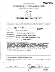
V - Missouri Department of Natural Resources
V - Missouri Department of Natural Resources
V - Missouri Department of Natural Resources

Create successful ePaper yourself
Turn your PDF publications into a flip-book with our unique Google optimized e-Paper software.
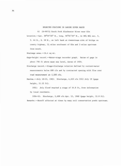
96<br />
SELECTED STATIONS IN L\HINE RIVER BASIN<br />
41 (6-9075) South Fork Blackwater River near Elm<br />
Location.--Lat. 38°49'05" N., long. 94°02'05" W., in SW\: SE\ sec. 5,<br />
r. 46 N.• R. 28 W., on left bank at downstream side <strong>of</strong> bridge on<br />
county highway, 2% miles southeast <strong>of</strong> Elm Bnd 3 miles upstream<br />
from mouth.<br />
Drainage arca.--16.4 sq mi.<br />
Gage-height record.--Water-stage recorder graph. Datum <strong>of</strong> gage is<br />
about 795 ft above mean sea level, datum <strong>of</strong> 1929.<br />
Discharge record.--Stsge-discharge relation defined by current-meter<br />
measurements below 600 cfs and by contracted opening with Clow over<br />
road measurement at 5,600 cfs.<br />
Maxlma.--July 18-23, 1965: Discharge, 4,610 cfs 2245 July 19 (gage<br />
height, 11.12 ft).<br />
1951: July flood reached a stage <strong>of</strong> 14.8 ft, from information<br />
by local residents,<br />
1954-65: Discharge, 5,600 ds Apr. 15, 1960 (gage height, 12.0 ft).<br />
Remarks.--Run<strong>of</strong>f affected at times by many soil conservation ponds upstream.