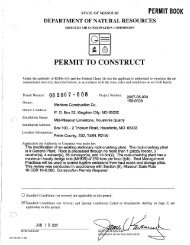
V - Missouri Department of Natural Resources
V - Missouri Department of Natural Resources
V - Missouri Department of Natural Resources

You also want an ePaper? Increase the reach of your titles
YUMPU automatically turns print PDFs into web optimized ePapers that Google loves.
10<br />
INTRODUCTION<br />
Outstanding floods occurred July 18-23, 1965 on <strong>Missouri</strong> River tributaries in an area east<br />
<strong>of</strong> the <strong>Missouri</strong> River extending [rom the lowa-Hissouri State line on the north to the Blackwater<br />
River basin on the south and east into the Grand River basin (fig. 1). Floodwaters [rom these<br />
tributaries produced extensive flooding on the Hissouri River from St. Joseph to its mouth near<br />
St. Louis.<br />
The floods were due to torrential rainfalls during July 17·20 following a 4-month period<br />
<strong>of</strong> near normal precipitation. Storm totals amounting to more than 20 inches were reported at<br />
Rockport and Edgerton. The Little Platte River at Smithville crested 7.4 feet higher than any<br />
previously known flood. The crest on the Platte River, 3% miles northeast <strong>of</strong> Agency, where a<br />
streamgaging station has been in operation since May 1924, was 4.6 feet higher than any prev<br />
iously recorded stage. Four lives were lost, 15 communities suffered damages and thousands <strong>of</strong><br />
acres <strong>of</strong> croplands were flooded.<br />
Purpose and Scope<br />
The purpose <strong>of</strong> this report is to document these outstanding floods for future hydrologic<br />
planning within the State. Data related to unusual floods are essential to wise development,<br />
within any basin, where the threat <strong>of</strong> potential flooding endangers public interests and public<br />
safety. This report presents storm and flood descriptions, damage estimates, peak stages and<br />
discharges, flood pr<strong>of</strong>iles, station data, and discharge hydrographs for the floods <strong>of</strong> July 18<br />
23, 1965 and indicates the unusually high recurrence interval <strong>of</strong> both rainfall and run<strong>of</strong>f assoc<br />
iated with this storm.<br />
Cooperation and Acknowledgments<br />
Rainfall data in this report were collected by the Weather Bureau precipitation gaging<br />
network and several precipitation gages operated by the U. S. Geological Survey in connection<br />
with streamflow network operation. The Weather Bureau and Corps <strong>of</strong> Engineers collected addition<br />
al rainfall information by contacting local residents in areas <strong>of</strong> intense rainfall. These data<br />
were used by the Weather Bureau in preparing an isOhyetal map and representative mass rainfall<br />
curves for the storm. The data are published in the July 1965 issues <strong>of</strong> Monthly Climatological<br />
Data and Hourly Precipitation Data for Iowa, Nebraska and <strong>Missouri</strong>. Hourly precipitation data<br />
collected by the U. S. Geological Survey at Blairstown, Osborn, and Arrow Rock, <strong>Missouri</strong> were not<br />
published but are available from the District <strong>of</strong>fice in Rolla, <strong>Missouri</strong>. The sections on meteor<br />
ological conditions and on rainfall intensity and distribution were prepared by the Environ<br />
mental Science Services Administration, Weather Bureau, Kansas City, <strong>Missouri</strong>. Flood damage