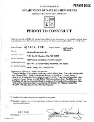
V - Missouri Department of Natural Resources
V - Missouri Department of Natural Resources
V - Missouri Department of Natural Resources

Create successful ePaper yourself
Turn your PDF publications into a flip-book with our unique Google optimized e-Paper software.
TABLE 4 -- continued<br />
SUMMARY OF PEAK STAGES AND DlSCHARGES FOR FLOODS OF JULY 18-23, 1965 AND CQiPARISON<br />
WITH MAXIMmt FLOODS PREVlOUSLY KN(),.'N<br />
* Ratio <strong>of</strong> peak discharge to 50-year flood discharge.<br />
a Affected by backwater from ice.<br />
b computed by Corps <strong>of</strong> Engineers.<br />
c Outside gage stage <strong>of</strong> 18.8 ft.<br />
d Also, stage at unknown date prior to 1932, from floodmarks.<br />
e Stage at point on right bank, 200 ft upstream from gage. Floods <strong>of</strong> July 6, 1951 and July 19, 1965.<br />
reached stages <strong>of</strong> 20.0 and 19.7 ft, respectively, at same point (from floodmarks).<br />
f Discharge unknown.<br />
g Occurred two days earlier than peak discharge.<br />
h Affected by backwater and overflow from <strong>Missouri</strong> River.<br />
i Levee break, discharge occurred after crest at stage <strong>of</strong> 28.0 ft.<br />
j Occurred 5 hrs earlier than peak stage.