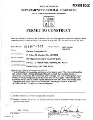
V - Missouri Department of Natural Resources
V - Missouri Department of Natural Resources
V - Missouri Department of Natural Resources

Create successful ePaper yourself
Turn your PDF publications into a flip-book with our unique Google optimized e-Paper software.
12<br />
estimates and flood photographs were furnished by the Corps <strong>of</strong> Engineers. Flood pr<strong>of</strong>iles were<br />
prepared jointly by the Corps <strong>of</strong> Engineers and U. S. Geological Survey. Streamflow data collec·<br />
tion was done by the U. S. Geological Survey with the financial cooperation <strong>of</strong> the 1'11550u[1<br />
Geological Survey and Water <strong>Resources</strong>, the Corps <strong>of</strong> Engineers, and the <strong>Missouri</strong> State Highway<br />
Commission.<br />
DESCRIPTION OF STOR!'IS<br />
Meteorological Conditions by U. S. Weather Bureau<br />
The meteorological conditions prevailing in the lower atmosphere during the flood period<br />
are shown by the charts in figure 2. which depict conditions on the 850 millibar (mb) surface.<br />
This level is about 4,000 feet above ground in northwestern <strong>Missouri</strong>. It will be seen that a<br />
quasi-stationary low center was located in the vicinity <strong>of</strong> Colorado and a quasi-stationary high<br />
was over or near Arkansas. A cold migratory high center moved down from Canada snd across Lake<br />
Michigan. To the south <strong>of</strong> the front a strong south-southwesterly low-level flow prevailed<br />
across Kansas and Oklahoma which prOVided an abundant moisture supply from the Gulf <strong>of</strong> Mexico,<br />
a necessary condition for heavy rain in the central United States. The front served as a<br />
"trigger" mechanism to induce a convergence <strong>of</strong> the low-level water vapor transport in the rain<br />
area..<br />
The surface temperature contrast across the front was quite marked. Mid-afternoon temper<br />
atures on July 18 and 19 were in the upper 90's and lower 100's in south-central and southeast<br />
ern Kansas. Afternoon temperatures to the north <strong>of</strong> the front were in the upper 70's and lower<br />
80's on July 18 and even cooler July 19 when they were in the lower 70's in northern <strong>Missouri</strong><br />
and in Iowa. The 850 mb isotherms (dotted lines) in figure 2 also indicate a strong tempera<br />
ture gradient. Cloudiness and cooling by evaporation <strong>of</strong> falling raindrops to the north <strong>of</strong> the<br />
surface position <strong>of</strong> the front helped to maintain this temperature contrast. The rain area may<br />
be considered to have had a tendency toward self-perpetuation, in the sense that rain and<br />
clouds helped to maLntain a temperature gradient favorable for further rain.<br />
Slowly-changing weather situations such as rhis one are more likely to be flood-producing<br />
for the reason that the rainfall is concentrated in a small area, rather than being spread over<br />
a larger area, as it would be in a more rapidly-moving situation. Steering-level winds (10,000<br />
ft and up) were light west-northwesterly and radar data show that precipitation echoes in the<br />
rain area moved generally in an east-southeasterly direction at 15-25 knots (l knot = 1.15<br />
miles per hour). TIlere was a persistent regeneration <strong>of</strong> echoes upstream in the steering-level