New methods in urban analysis and simulation
Documentation of teaching results from the spring semester 2015 of the seminar Digital Urban Simulation at the Chair of Information Architecture, ETH Zurich
Documentation of teaching results from the spring semester 2015 of the seminar Digital Urban Simulation at the Chair of Information Architecture, ETH Zurich

Create successful ePaper yourself
Turn your PDF publications into a flip-book with our unique Google optimized e-Paper software.
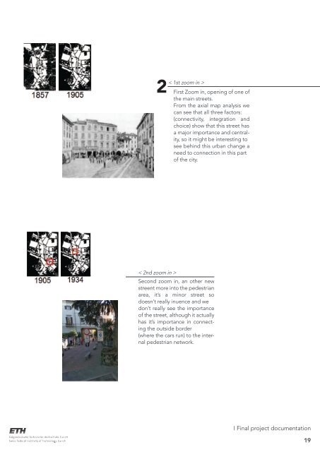
2<br />
< 1st zoom <strong>in</strong> ><br />
First Zoom <strong>in</strong>, open<strong>in</strong>g of one of<br />
the ma<strong>in</strong> streets.<br />
From the axial map <strong>analysis</strong> we<br />
can see that all three factors:<br />
(connectivity, <strong>in</strong>tegration <strong>and</strong><br />
choice) show that this street has<br />
a major importance <strong>and</strong> centrality,<br />
so it might be <strong>in</strong>terest<strong>in</strong>g to<br />
see beh<strong>in</strong>d this <strong>urban</strong> change a<br />
need to connection <strong>in</strong> this part<br />
of the city.<br />
< 2nd zoom <strong>in</strong> ><br />
Second zoom <strong>in</strong>, an other new<br />
streent more <strong>in</strong>to the pedestrian<br />
area, it’s a m<strong>in</strong>or street so<br />
doesn’t really <strong>in</strong>uence <strong>and</strong> we<br />
don’t really see the importance<br />
of the street, although it actually<br />
has it’s importance <strong>in</strong> connect<strong>in</strong>g<br />
the outside border<br />
(where the cars run) to the <strong>in</strong>ternal<br />
pedestrian network.<br />
I F<strong>in</strong>al project documentation<br />
19