transnational northeast
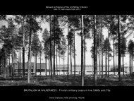
ULDX abstracts - Between Architecture of War and Military Urbanism
ULDX abstracts - Between Architecture of War and Military Urbanism
- No tags were found...

Create successful ePaper yourself
Turn your PDF publications into a flip-book with our unique Google optimized e-Paper software.
Laura Lieto<br />
(Un)restricted access. The US militarization in the formation of<br />
Naples city-region after WWII<br />
Eric Le Bourhis<br />
“Not any of us in the Republic is prepared”: The response of Riga<br />
city planners to new soviet civil defence norms in 1956-1957<br />
The paper’s main theme is the influence of American<br />
militarization over processes of urban growth and<br />
metropolization that occurred in the region of Naples,<br />
Italy after WWII.<br />
Naples has been, since the Cold War, one of the major<br />
logistic and command nodes supporting the overall<br />
strategy of defense and occupation sanctioned by the<br />
NATO. Provided with one of the largest harbors of the<br />
Mediterranean, the city, since then, has been the major<br />
headquarter of US Navy in the Southern quadrant of<br />
Europe, a strategic node within a global network of<br />
geopolitical power.<br />
The influence of American military and civil settlements<br />
over the formation of Naples metropolitan region in the<br />
second half of the 20th century is here acknowledged<br />
within a broader conceptualization of the processes<br />
at hand, regarded as “assemblages” of actors,<br />
international agreements, local planning policies,<br />
material infrastructures, endogenous economic and<br />
social processes, technologies, life styles and cultures.<br />
This approach takes into account the “native”<br />
mode of planning driven by the military remapping<br />
of America that occurred after WWII in the US, to<br />
make an hypothesis about how ideas, approaches<br />
and processes experimented in the US “Gunbelt”<br />
have been traveling around Europe, and in Italy<br />
in particular, to “land” in specific contexts selected<br />
for strategic and logistic reasons within the NATO<br />
strategy of land protection and occupation. The <strong>transnational</strong><br />
dimension of planning is here in point, as the<br />
mainframe to develop such a case.<br />
In this perspective, Naples city-region seems a quite<br />
relevant context to investigate forms and processes<br />
of hybridization of different modes of planning and<br />
social production of space, entangling the military<br />
logics of closure, protection, security and defense<br />
with different patterns of urban growth that, driven by<br />
economic, demographic, environmental processes<br />
of metropolization arising during the decades after<br />
WWII as endogenous effects of massive urbanization<br />
processes of Italian southern regions. The paper’s<br />
claim is that these hybrid patterns are relevant to<br />
understand the contemporary metropolitan dimension<br />
of this city region. Hybrid forms of urbanization are<br />
the main “objects” this paper will focus on: from the<br />
western outskirts suburban development, where the<br />
new NATO base has been built on the old US site of<br />
Lago Patria, enmeshing the typical American suburban<br />
scape with the low-density historical rural landscape,<br />
to the major retail strip, built during the American<br />
occupation in the 1940s, connecting the western and<br />
eastern parts of the inner region; from the new gated<br />
community of the US Navy Support Site in the <strong>northeast</strong><br />
region, to the permanent “state of exception”<br />
of part of the historical harbor. Naples offers a wide<br />
array of cross-border urban patterns addressing<br />
the metropolization process that, in about 50 years,<br />
has featured the uncertain position of this city in the<br />
international urban panorama, in between a low-rank<br />
metropolis (Naples is the third Italian city, after Milan<br />
and Rome) and a global node for geo-political power.<br />
___________________________________________<br />
Laura Lieto is a professor of urban planning at Federico<br />
ll University in Naples. Her main thematic field is spatial<br />
planning as a communicative practice in pluralist and<br />
conflicting social arenas, framed by Foucauldian<br />
power-knowledge theories. In such a theoretical<br />
perspective, she has been focusing on place-making<br />
practices, to investigate their problematic and aporetic<br />
nature in a practical planning perspective, developing<br />
and testing such a theme through field research on<br />
some neighborhoods of inner Naples.<br />
She is now focused on a research program framed by<br />
major theories and debates on the American Empire,<br />
aiming at a contribution to this field of studies from a<br />
specific planning perspective. The main theme is the rise<br />
of the American metropolis as a spatial power device<br />
of global capitalism in the 20th century, investigated<br />
both as a product of the American exceptionalism and<br />
as an outcome of cultural interdependencies between<br />
Europe and the US. The first results of this research<br />
program have recently been published in Italy.<br />
In August 1956, J. Augškaps, chairman of the<br />
State Committee of Construction of the Latvian<br />
Soviet Republic, opened a meeting on the change<br />
of the civil defence course in the USSR (местная<br />
противовоздушная оборона or MPVO in Russian)<br />
with the words: «Not any of us in the Republic is<br />
prepared». Indeed, the imposition by the Council<br />
of Ministers of the USSR in June 1956 of new civil<br />
defence standards for city planning – taking into<br />
account a renewed nuclear threat – came on a local<br />
level in contradiction with the guidelines of the sixth<br />
Five-Year plan.<br />
Scholars have long stressed the importance of<br />
the issues of civil defence in city planning in North<br />
America and in Europe during the Cold War, especially<br />
the need for extensive functional planning, e.g.<br />
distances between residential and industrial areas.<br />
This question was of big concern in the western,<br />
middle-sized, industrial town of the USSR that Riga<br />
was. In the USSR the elaboration of civil defence<br />
norms in Moscow was highly secret but the norms<br />
were progressively integrated into planning norms<br />
that young city planners had to learn. However, these<br />
norms had common features with some principles of<br />
modern planning. For this reason it is difficult to a in the<br />
long term the influence of civil defence on planning–<br />
except on special objects – and the way planners<br />
seriously considered new standards at first.<br />
Declassified archive materials of the Academy of<br />
Architecture of the USSR show the rank of priority<br />
of the elaboration of those new norms in the agenda<br />
of Moscow academicians but also the inadequate<br />
consideration of local conditions in their work. In the<br />
case of Riga, local archive materials make it possible<br />
to measure the anxiety among republican and<br />
municipal organs that was caused by new standards<br />
of civil defence and further the strategies they adopted<br />
to face them in the context of Khrushchev reforms.<br />
Moreover, the starting elaboration of a regional plan<br />
for Riga gives us the opportunity to observe the partial<br />
results of these strategies before Moscow lightened<br />
the application of the standards already in April 1957.<br />
This case study is based on declassified archive<br />
materials of the Academy of Architecture and of the<br />
Committee of Construction of the USSR (Russian<br />
State Archive of the Economy) on the one hand, and<br />
of the Council of Ministers and of the Committee<br />
of Construction of the Latvian SSR (State archive<br />
of Latvia) on the other hand. It aims to formulate<br />
hypotheses on the practice of planning in the context<br />
of the implementation of new and radical but still secret<br />
norms.<br />
___________________________________________<br />
Eric Le Bourhis is a doctoral student at the Centre de<br />
recherches historiques of the École des hautes études<br />
en sciences sociales (EHESS) in Paris. His research<br />
relates to the practices of architecture and city<br />
planning at different scales in Soviet Latvia after World<br />
War Two and until the fall of the Soviet Union, taking<br />
into account both local and wider, socio-economic and<br />
political contexts (in Latvia and in the USSR) and the<br />
evolution of the professional identity of specialists of<br />
architecture and city planning.
Chris Karelse & Ken Sterrett<br />
The divided city: spatial segregation beyond the “peace-walls”<br />
An investigation into the spatial segregation patterns in the city of Belfast<br />
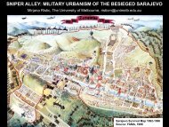
Mirjana Ristic<br />
Sniper alley: military urbanism of the besieged Sarajevo<br />
Since the outbreak of ‘The troubles’ in 1969, Belfast has<br />
seen the erection of an extensive network of barriers,<br />
commonly referred to as ‘peace-walls’. They were<br />
originally erected by the British army as temporary<br />
structures for the military purpose of controlling and<br />
containing the inter-communal violence that took<br />
a heavy toll in the city. These peace-walls have<br />
become an enduring feature in the urban landscape,<br />
particularly of West and North Belfast. Consequently,<br />
they have created a spatial fix for both Protestant and<br />
Catholic working class communities, hindering any<br />
truly sustainable reconciliation of the two communities.<br />
Although the peace-walls are a relatively recent<br />
urban phenomenon, arguably they have reinforced<br />
segregation patterns and significantly restricted<br />
patterns of movement. Moreover, their impact goes<br />
far beyond the temporary obstruction of local spatial<br />
relations. They also functioned as a starting point for<br />
the remodelling of urban street patterns in the context<br />
of housing redevelopment in the 1970’s and 1980’s.<br />
This saw new housing on both sides of the peacewalls,<br />
often characterized by a cul-de-sac type of<br />
urban morphology. In turn, this has created a more<br />
permanent form of spatial dis-connectivity between<br />
Protestant and Catholic communities and between<br />
working class communities and the rest of the city.<br />
The spatial fix that peace-walls and adjacent cul-desac<br />
type of housing redevelopments effectively have<br />
established is set within the context of a shifting<br />
demography in Belfast. An on-going increase in the<br />
Catholic population is paralleled by a decreasing<br />
Protestant population. This situation has led to a<br />
renewed importance of the concept of ‘contested<br />
space’, where both communities compete for access<br />
to services and facilities, by claiming to have ‘rights’ to<br />
certain lands. All of this highlights the highly polarized<br />
and politicized issue of sectarian geographies that<br />
continue to play a prominent role in the mind-sets of<br />
both main religious and cultural communities.<br />
Patterns of spatial segregation are based on religious<br />
and cultural divides and were established as a result<br />
of periods of violent conflict. These segregation<br />
patterns have subsequently been exacerbated by<br />
a poor planning practice, which, in an attempt to be<br />
apolitical, put its focus on a technocratic approach that<br />
avoided dealing with spatial divisions. This approach<br />
was land-use based, trend-led and market orientated.<br />
It attempted to ‘predict & provide’ but in doing so,<br />
confirmed and at times, reinforced the existing spatial<br />
divisions and the lack of interconnectivity between the<br />
different communities.<br />
This paper will investigate the relevance of the built<br />
environment for both understanding and resolving<br />
issues around the spatial divisions that continue to<br />
affect people’s daily lives in Belfast. The role of spatial<br />
planning in facilitating and contributing to a process of<br />
reconciliation between the two main religious/cultural<br />
communities is of a particular interest to the authors,<br />
especially in the light of upcoming changes to the<br />
planning system in Northern Ireland. What kind of new<br />
planning model, therefore, might offer opportunities<br />
to reintegrate adjacent Protestant and Catholic<br />
communities and address the range of barriers that<br />
disadvantage both communities in North and West<br />
Belfast.<br />
___________________________________________<br />
Christiaan Karelse graduated in Architecture from<br />
the Delft Technical University and now works as a<br />
research assistant in Queen’s University’s School of<br />
Planning, Architecture & Civil Engineering, where he is<br />
currently involved in the research project ‘Planning for<br />
Spatial Reconciliation’. His research work focuses on<br />
the contribution that urban planning and architecture<br />
can make in resolving conflict in societies.<br />
Ken Sterrett has been a lecturer in Queen’s<br />
University’s School of Planning, Architecture & Civil<br />
Engineering since 1994. He previously worked in<br />
professional practice as a senior planner and was<br />
an advisor to the Belfast Action Teams on a number<br />
of peace-line projects. Ken is a co-investigator on a<br />
number of research projects such as CU2 (Contested<br />
Cities, Urban Universities); Planning Shared Space for<br />
a Shared Future; Skills for Sustainable Communities;<br />
and ‘Public Space for a Shared Belfast’, and most<br />
recently, ‘Planning for Spatial Reconciliation’.<br />
Since the beginning of 1990, after a long history of<br />
multiculturalism, Bosnia and Herzegovina suffered<br />
a resurgence of ethnic nationalism and a civil war<br />
fought over purification of ethnic identity. Urban built<br />
environments of Bosnian cities became implicated in<br />
this conflict, as they operated not only as the sites and<br />
targets of the war, but were used as the very means<br />
by which the war was fought. This paper discusses<br />
the ways in which a constellation of civil architecture<br />
and urban space in the central part of the Bosnian<br />
capital, Sarajevo, was adopted for the purposes of<br />
military violence during the siege of 1992-1995. The<br />
focus is on the violence against non-military targets:<br />
sniping of civilians who were moving, gathering<br />
and mixing in public spaces. “Sniper Alley” was the<br />
name that emerged in the world’s media to describe<br />
a strip of urban space that was the most intensively<br />
attacked. This paper elaborates on the ways in which<br />
the assemblage of urban geography and morphology<br />
of the besieged Sarajevo was adapted to invest Sniper<br />
Alley with terror through which spatial practices of<br />
everyday ethnic gathering and mixing were denied. It<br />
also discusses the effects of such violence and terror<br />
on the reconstitution of Sarajevo’s street network and<br />
urban connections that sustained the city’s multi-ethnic<br />
urban life. The aim of the discussion is to understand<br />
the role that such urban transformations of Sarajevo<br />
played in the politics of ethnic identities in Bosnia<br />
and Herzegovina after its independence in 1992.<br />
The argument is that the wartime appropriation of the<br />
cityscape for sniping violence resulted in severing<br />
urban connections and patterns of everyday life that<br />
sustain Sarajevo’s ethnic mix and affected a certain<br />
level of ethnic division of the city and separation of its<br />
population.<br />
__________________________________________<br />
Mirjana Ristic graduated at the Faculty of Architecture,<br />
University of Belgrade, Serbia in 2005. She practiced<br />
architecture and engaged in research in the area of<br />
urban design at the Research and Business Centre<br />
of the Faculty of Architecture in Belgrade, from 2005<br />
to 2006. She received her PhD from the University of<br />
Melbourne in 2011. She has thought and researched<br />
urban design and theory at the Faculty of Architecture,<br />
Building and Planning, the University of Melbourne<br />
since 2008.
Nancy Couling<br />
The military space of the ocean<br />
James Montgomery Wollen<br />
Architects of a would-be state: Lithuanian publicists on the demographics and<br />
economics of Lithu-Letto federation, 1914-1918<br />
Within a proposed conference topic Political economy<br />
of land, this abstract proposes an examination of the<br />
Political economy of the sea, the complexities in the<br />
relationship of political geography and military practice,<br />
the boundary and interpenetration between military<br />
and non-military spatial fixes in the sea.<br />
Spatially a confluent realm, the ocean provides the<br />
opportunity for ambiguities and changing strategic<br />
compositions with an ephemeral character, yet<br />
which leaves heavy traces. International waters,<br />
which lie outside national legal jurisdiction, are a<br />
common resource of mankind, yet a spatial resource<br />
increasingly controlled by a latent military presence.<br />
The military colonizes fringe territories, including the<br />
ocean, which has traditionally been a site for military<br />
exercises, tests and war itself. Currently DARP, the<br />
US Defense Advanced Research Projects Agency<br />
have released plans to deposit what they call “upward<br />
falling payloads” on the ocean floor. These are remotecontrolled,<br />
“non-lethal weapons and situationalawareness<br />
sensors”, which rise to the surface on<br />
command to scare the enemy at sea.<br />
This paper examines this notion in relation to work<br />
carried out by laba - laboratoire Bâle, an EPFL (Ecole<br />
Polytechnique Fédérale de Lausanne) satellite urban<br />
design studio in Basel, Switzerland. Our 2011/12<br />
study was focussed on the Barents Sea, and territorial<br />
constitutions for this ocean were developed as well as<br />
architectural propositions. Starting with the hypothesis<br />
that the ocean is becoming an increasingly urbanized<br />
territory, this study focuses on infrastructure as a<br />
generator of urbanity.<br />
The strategic location of the Barents Sea during the<br />
Cold War led to extensive accumulation of military<br />
infrastructure. Currently, this location is strategic in<br />
terms of as yet largely untapped fossil fuel reserves<br />
and the new Northern Sea Route, both which profit<br />
from the rapidly receding ice-front. Further north,<br />
the Arctic Ocean is subject to territorial claims by all<br />
surrounding countries, unleashing an “Arctic Resource<br />
Race” fueled by the assumption that rich reserves lie<br />
on and below the seabed.<br />
Similarly, tensions in the East China Sea between<br />
China and Japan have led to increased military<br />
presence, since the islands in question represent<br />
access to the surrounding ocean resources.<br />
Current research is focused on the Baltic Sea, the<br />
German EEZ in particular. Historically, for example in<br />
the Viking & Hanse trading periods, military strength<br />
was used to guarantee safe passage for trade, hence<br />
demonstrating the balance of interests between<br />
economy and war.<br />
This paper will compare the results of these two case<br />
studies, trace the spatial realm of military practices<br />
over ocean territory and discuss the characteristics of<br />
ocean space, which enable such military maneuvers.<br />
___________________________________________<br />
Nancy Couling’s background is in architectural studies<br />
in Auckland, New Zealand and has studied in I.U.A.V.<br />
Venice with a post-grad scholarship. She practiced for<br />
5 years in New Zealand before gaining experience in<br />
Europe, Hong Kong and Australia, e.g. Massimiliano<br />
Fuksas, Rome, Otto Steidle, Munich, Christoph<br />
Langhof, Berlin, Liang Peddle Thorp, Hong Kong and<br />
LAB Architecture Studio, Melbourne<br />
She formed the interdisciplinary partnership cetcet-01<br />
in Berlin 1995, focusing on urban design and<br />
developing prototypes in applied research (www.cet-<br />
01.de).<br />
She has taught at the Technical University Berlin,<br />
chair for urban design, Prof. Klaus Zillich 2000-2005<br />
and 2008-2009. She has been working as a research<br />
assistant to professor Harry Gugger EPFL since 2010.<br />
She researched and coordinated the Barents Sea<br />
project 2011/12 (http://laba.epfl.ch). Couling has been<br />
in doctoral studies writing on the urbanization of the<br />
sea since February 2011.<br />
It is not only belligerent states with colonial aspirations<br />
that covet territory during times of war. Victims of<br />
aggressors may use conflicts as a vehicle for territorial<br />
acquisition.<br />
During the closing stages of the First World War<br />
Lithuanian publicists advocated the federation of<br />
the nascent states of Latvia and Lithuania. This all<br />
but forgotten episode is an example of the political<br />
economy of land during the early twentieth century. It<br />
demonstrates that even states which do not formally<br />
exist can attempt to profit from war, both economically<br />
and territorially.<br />
In Lithuanian political thought, the idea of a union<br />
between Latvians and Lithuanians can be traced<br />
back to the mid-1880s. However, Latvians were less<br />
enthusiastic about the proposition with the majority<br />
of them dismissing the notion outright. In 1916,<br />
a joint Latvian-Lithuanian conference resulted in<br />
the categorical rejection of the idea by the Latvian<br />
contingent. Nevertheless, Lithuanian publicists<br />
continued to espouse the notion, disseminating<br />
propaganda to international political representatives.<br />
There appears to have been no common interpretation<br />
of the relationship between Latvians and Lithuanians.<br />
Often publicists of the same organisation provided<br />
strikingly incongruent information. An analysis of<br />
textual sources reveals that arguments were based<br />
less on restoring an attested historical rapport between<br />
the two nations and more on Lithuania’s pursuit of<br />
territorial and economic security.<br />
___________________________________________<br />
James Montgomery Wollen was born in England in<br />
1985 but has spent most of his adult life studying and<br />
working in Eastern Europe. He gained the degree of<br />
BA (Hons.) History in 2010 and an MA Comparative<br />
History of Eastern, Central and Southeastern Europe<br />
in 2012. Amongst other teaching positions, James<br />
has taught at Tallinna Ülikool (Tallinn University) and<br />
Valgamaa Kutseõppekeskus (Valga County Vocational<br />
Training Centre). James is currently spearheading<br />
the MYCAT (Mapping Youth Culture and Alternative<br />
Tradition) project for Noor-Eesti Loomekeskus, Tartu,<br />
as part of a European Voluntary Service placement.<br />
He is also a co-founder and director of MTÜ Villane<br />
Raamat, which publishes the “sister” short story<br />
journals ELLA ( Eesti lühilugude ajakiri ) and JESS<br />
(Journal of Estonian Short Stories ).
Dylan Craig<br />
Something old out of Africa: Interstitial war as a resurgent global phenomenon<br />
Nikolina Bobic<br />
War, violence and control: a De/re-modernisation and de/re-territorialisation<br />
through infrastructure<br />
The architecture of war and the architecture of political<br />
authority are fundamentally connected, not only in<br />
practice but also by definition and as a prerequisite<br />
to scholarly analysis. For example, the idea that<br />
the post-medieval state drew its form from the twin<br />
tasks of suppressing or accommodating “internal”<br />
challengers while holding off “external” rivalas (as<br />
per the arguments of Charles Tilly), directly links the<br />
architecture of political authority (i.e., the coercive<br />
monopoly of the state exerted through and within a<br />
range of territorialized institutions) to the location of<br />
war, both in physical and social space, as taking place<br />
“inside” or “outside” the state.<br />
In this regard, recent evolutions in the form of the state<br />
have produced a range of evolutions in the form of war,<br />
and vice versa. For example, the existence of a stateand<br />
state-system-based norm against “aggressive”<br />
war since 1945, has increased the proportion of wars<br />
aimed not at conquest or violent bilateral coercion (i.e.,<br />
conventional politics by other means), but at military<br />
outcomes which respond to the “new politics” of<br />
identity, globalization and the democratic peace, such<br />
as regime change and genocide.<br />
While there is a tendency to divide these military<br />
evolutions into regressive (“new barbarism”) and<br />
progressive (“technowar”) forms, in this paper I<br />
argue that “war remains war” - albeit that the military<br />
architecture of the global battlefield, in geopolitical<br />
terms, has shed the spatial constraints of the late-<br />
Westphalian era and returned to the complex, multidimensional,<br />
and non-exclusive configuration which it<br />
had exhibited for most of human history. This can be<br />
seen primarily in the architecture of modern conflict:<br />
i.e. where it takes place, socially and physically,<br />
and which actors this location allows. In this new<br />
architecture of war, I characterize the battlefields as<br />
existing within “sovereign interstices” – spaces that<br />
are not ungoverned as much as they are multiply or<br />
non-exclusively governed. To illustrate this, I present<br />
historical and statistical data on the proxy wars of<br />
post-colonial Africa, and argue (through reference to<br />
other theaters of modern war) that the core features of<br />
African proxy war since 1950, represent the future of<br />
war more generally.<br />
___________________________________________<br />
Dr Dylan Craig is a professorial lecturer in the<br />
International Politics division of American University’s<br />
School of International Service. His current research<br />
project is a comparative study of ‘sovereign<br />
interstices’: the geopolitically complex spaces and<br />
places within which states both modern and historical<br />
have responded to strategic and tactical constraints<br />
by intermediarizing (e.g. through proxies) or<br />
technologizing (e.g., through drones) their foreign and<br />
domestic security practices. His work on the sovereign<br />
intersticae received the 2010 ISA Best Security<br />
Studies Paper award. Dr Craig’s other research<br />
interests include pre- and post-colonial African politics,<br />
research methodology in international studies, and<br />
military history.<br />
NATO’s 1999 targeting of Belgrade is an example of<br />
war, violence and control enacted in multiple modes.<br />
Strategies deployed include high-tech information<br />
operations (technology), neo-liberalism (economy),<br />
de-modernisation (temporality), de-socialisation<br />
(social welfare), and claiming the “legality” of violence<br />
against a “rogue” state (semi-colonialism and the law).<br />
Temporally, the campaign can be seen to range from<br />
short, long and indefinite-term operations. The shortterm<br />
operation was NATO’s 1999 Operation Allied<br />
Force, a high-intensity air campaign that lasted for<br />
seventy-eight days, where architecture was destroyed,<br />
and cities, particularly Belgrade, de-modernised. The<br />
long-term operation was of medium intensity, and<br />
began prior to the 1999 NATO attack at the start of<br />
the disintegration of the Socialist Federative Republic<br />
of Yugoslavia in 1990-91. The dissolution saw the<br />
imposition of economic sanctions and travel embargos<br />
on the Federative Republic of Yugoslavia (FRY) and<br />
its capital Belgrade beginning in 1993, remaining<br />
operative into the 2000s. The longer-term and perhaps<br />
indefinite operation is still taking place. It is a lowintensity<br />
and high-tech conflict deployed with the<br />
intention of de-socialisation through (re)formation/(re)<br />
construction of urban spaces and society in general<br />
after 1999. It is being facilitated by rapid changes to<br />
infrastructure, law, privatisation of companies, and<br />
transformation of territorial relationships. Its outcome<br />
is the transformation from a once alternative socialist<br />
country (Titoism) into a hegemonic zone.<br />
This paper explores the role of infrastructure in<br />
facilitating NATO 1999 offensive. The items of<br />
infrastructure examined are both directly and<br />
indirectly related to canals, sites of death, cemeteries<br />
and transport routes. These contemporary uses<br />
of infrastructure will focus on how NATO deployed<br />
satellites, unmanned drones and wires to survey, map<br />
and provide evidence of a “humanitarian catastrophe”<br />
in Kosovo and Metohija. By appropriating high-tech<br />
information and infrastructure operations in the face of<br />
“terror”, NATO was able to undermine sovereign state<br />
law for the purpose of achieving its military objectives.<br />
It is argued that the underlying agenda was to gain<br />
access to FRY air space by deploying a narrative of<br />
emergency and global (in)security.<br />
NATO’s targeting of Serbia and Belgrade in 1999<br />
was not simply a matter of flattening, or utilising<br />
Stephen Graham’s terminology de-modernising, the<br />
city’s economic, social and infrastructure canals,<br />
but also, through the interchange of long and shortterm<br />
military operations, about creating a discourse<br />
whereby dependence on another system would be<br />
required in order for the country and city to rebuild<br />
themselves. One key aspect of this re-modernisation/<br />
re-territorialisation includes an uneven incorporation<br />
of infrastructure services and resources into the<br />
wider European and globally smooth network for the<br />
purposes of defense and “security”.<br />
___________________________________________<br />
Nikolina Bobic is an architect and a PhD candidate at<br />
the University of Sydney [USYD]. Bobic received her<br />
Architecture degree with Honours Class 1 and Arts<br />
degree in Sociology from the University of New South<br />
Wales [UNSW] in 2005. She teaches in Architecture<br />
and Sociology at the USYD, UNSW and UTS<br />
[University of Technology Sydney].<br />
Her research explores the emergence of the<br />
contemporary phenomenon known as urbicide. The<br />
particular focus is on NATO’s urbicidal incursion<br />
on Belgrade during 1999 and beyond. Research<br />
draws on connections found in economy, law, media<br />
and technology, and deployed in military strategies<br />
to control the physical and psychological space of<br />
Belgrade. She was awarded a coveted Australian<br />
Postgraduate Award Research Scholarship to support<br />
this PhD research.<br />
Bobic’s research also deploys art to explore two key<br />
ideas: connections between control, violence and<br />
resistance - and - memory and history as constructs of<br />
‘visibility’. Her research papers have been presented<br />
and published nationally and internationally.
Parastou Saberi<br />
Space, everyday life and the modalities of (neo-)colonial pacification<br />
Suzanne Harris-Brandts<br />
Extraterritorial appropriation: Landscape’s instrumentality in the conflicting<br />
land claims of the occupied West Bank<br />
This paper approaches the question of the<br />
boundary between the military and the civil in<br />
relation to the urban built environment from the<br />
perspective of counterinsurgency/pacification<br />
theories and operations. Since the re-emergence<br />
of counterinsurgency doctrine among the Coalition<br />
partners in Afghanistan in 2006, military and non-military<br />
scholarly interests in the history and politics of this<br />
doctrine has been increasingly revitalized. The allure<br />
of counterinsurgency resides in the defining feature<br />
of this form of warfare, namely, the official blurring of<br />
the military and civil strategies through the functional<br />
integration of destruction and (re)construction in<br />
order to demobilize opposing forces of resistance by<br />
wining the “hearts and minds” of the population. More<br />
recent critical research on counterinsurgency has<br />
highlighted the deep colonial roots of this civil-military<br />
warfare, tracing its lineage back to the European latecolonial<br />
warfare, the French colonial rule, and the<br />
Spanish colonization of South America in the late 16th<br />
century. Capitalizing on the re-organization of entire<br />
societies under the guise of stabilization, strategies<br />
of pacification have been crucial in reproducing the<br />
socio-spatial relations necessary for the survival<br />
of colonial rule and specifically of (neo-) colonial<br />
indirect rule. The importance of civilian interventions<br />
integral to counterinsurgency/pacification,<br />
however, has resulted in an overemphasis on the<br />
management of population in the current critiques<br />
of counterinsurgency. Consequently, there exists a<br />
lack of interrogating the role of space in general, and<br />
urban space in particular, in the actual strategies of<br />
pacifying the population. This paper aims to address<br />
this imperative gap. Building on and going beyond<br />
the insights of the recent contributions, I excavate the<br />
importance of the destruction and (re)construction of<br />
the built-environment and the re-organization of the<br />
material topography in the projects of pacification. I<br />
suggest that Henri Lefebvre’s theorization of space<br />
and state and his dialectical approach to the urban<br />
question provide us with invaluable tools both to enrich<br />
theoretical debates and to sharpen political criticism of<br />
the contemporary rediscovery of colonial techniques<br />
of power, violence and domination. This approach<br />
facilitates future comparative studies between different<br />
modalities of pacification in the peripheral urban<br />
spaces of the imperial heartlands of liberal democracy<br />
and the conflict zones of global peripheries.<br />
__________________________________________<br />
Parastou Saberi holds a B.Arch. and an M.Arch., as<br />
well as a M.A. in sociology. She is currently a PhD<br />
candidate in the Faculty of Environmental Studies<br />
at York University (Toronto, Canada). Her doctoral<br />
dissertation examines the multi-scalar role of the state<br />
in forging a nexus of security-development-pacification<br />
at the urban level with a specific geographic focus on<br />
Toronto, Canada.<br />
The tracking, documenting, and verification of land<br />
usage in the West Bank occur on a scale and intensity<br />
among the most extreme on earth. Using state-ofthe-art<br />
satellite imagery, the lifespan and cultivation<br />
frequency of olive and fruit trees is being meticulously<br />
monitored by the Israeli Land Appeal Committee.<br />
The exhaustive collection and analysis of this data<br />
is not being done for ecological reasons tied to plant<br />
health or global warming, but for political reasons of<br />
extraterritorial jurisdictional control across Israel’s<br />
frontier of the 1949 Armistice ‘Green Line’. Palestinian<br />
agricultural Miri land which is not in conformity with tight<br />
Israeli usage regulations is rendered susceptible to<br />
seizure by the state, after which time it is re-designated<br />
as Makhlul land, or ‘State land’, and placed under the<br />
possession of the Israeli government. Tracing these<br />
seizure practices, their supporting spatial apparatuses<br />
and the legalistic manipulations which have enabled<br />
de facto Israeli annexation of Palestinian land to occur,<br />
this paper uncovers the complex utilization of nature<br />
and landscape for geopolitical means in the West<br />
Bank.<br />
In their silent, yet spatially consuming forms, plants<br />
and trees are frequently presumed to be politically<br />
neutral and passive in military occupations, at most<br />
serving as a vulnerable backdrop to conflict or one of<br />
its tragic casualties. However, the innumerable actors<br />
of the Israeli-Palestinian conflict have utilized nature<br />
as both a medium and agent for power retention. The<br />
hidden potentiality for dirt, trees, flowers and insects to<br />
cause ripples in the geopolitical status of this contested<br />
territory should therefore never be underestimated.<br />
In the absence of mutually-agreed sovereignty, the<br />
natural environment has the capacity to be imbued with<br />
complex socio-political narratives and, indeed, over<br />
the course of several decades of military occupation,<br />
nature has become an immense facilitator of political<br />
change in the West Bank, in both direct and indirect<br />
ways.<br />
Israel’s ability to control the lands of the West<br />
Bank for future annexation and Jewish-only<br />
settlement expansion has relied heavily upon such<br />
environmentally-linked approaches. Cultivation laws<br />
serve not only to regulate the agricultural landscape,<br />
but also to restrict economic competition with Israel’s<br />
agricultural sector and to promote a dependency<br />
upon outside imports. Likewise, nature reserves<br />
exist as places of not only conservation, but also<br />
prohibition; zones where Palestinian land purchase is<br />
forbidden, simple Palestinian residential construction<br />
is prevented, and even animal grazing is in violation<br />
of the law. By unpacking how opposing land claims<br />
can be choreographed by the inner workings of their<br />
landscapes, this paper explores the all-encompassing<br />
complexity of military occupation in this Middle<br />
Eastern region, as it blurs states of suspended war<br />
with the practices of everyday civil life. The paper<br />
culminates in the author’s own design response to<br />
nature’s politization in the West Bank. Playing off<br />
the occupation’s complex laws and military decrees,<br />
it suggests how a tactical approach to Palestinian<br />
territorial reclamation, economic stimulation and<br />
environmental remediation might be found within<br />
the same multifaceted natural ecologies that have<br />
been utilized by Israel to restrict Palestinian spatial<br />
contiguity.<br />
___________________________________________<br />
Suzanne is a Toronto-based architect who graduated<br />
from the University of Waterloo in Canada. Her work<br />
investigates the role of architecture and landscape in<br />
shaping land claims and military practices in the Israelioccupied<br />
West Bank. Culminating from her research,<br />
she has produced a series of design tactics which<br />
explore landscape’s instrumentality as a subversive<br />
tool for Palestinian territorial reclamation. In 2010<br />
and 2011 Suzanne was an ‘architect in residence’ at<br />
‘DA/AR: Decolonizing Architecture’, in Beit Sahour,<br />
Palestine. She is currently an Assistant Adjunct<br />
Professor at the University of Waterloo’s School of<br />
Architecture.
Neil Balan<br />
“Society’s infrastructures must be defended!”<br />
On sapper epistemology and epidemiological conceptions of contemporary<br />
warfare<br />
Matthew Bolton<br />
From minefields to minespace: landmines, autonomous armed robots and<br />
dynamic military enclosure<br />
The paper animates and explains the positive and<br />
negative biopolitical contexts of contemporary<br />
warfare—life sacks, life-preservation zones, and<br />
making life live; kill sacks, life-negating zones, and<br />
making life die—through the figure of the sapper,<br />
historically known as the agent of military engineering.<br />
In an era of civil-military coordination, information<br />
operations, and joint-enabled network-centric<br />
capabilities, the sapper remains a productive site for<br />
interrogating the act, event, and intelligibility of war.<br />
Using the American-led counterinsurgency war in<br />
Afghanistan, I consider the sapper in relation to<br />
current military doctrine regarding complexity and<br />
“the continuum of operations.” This philosophy<br />
pollinates the current round of North Atlantic-led<br />
expeditionary wars and interventions in which military<br />
actors conceptualize, design, and produce streams of<br />
perceptible and imperceptible violence, undertaking<br />
kinetic and non-kinetic measures with variable<br />
velocities and “speeds” depending on the desired<br />
enemy-centred or population-centred orientation of<br />
force.<br />
Sappers are commonly understood as agents shaping<br />
and inscribing the necessary built environments for<br />
warfare—what Virilio has called, in physical and<br />
metaphysical terms, the theatre of operations. I offer<br />
a reassessment of the sapper in an era where statewaged<br />
warfare is indexed to universalizing rhetorics<br />
of cosmopolitanism, human rights, and peace; and<br />
to instrumentally sustaining local political ecologies,<br />
infrastructures, and ways of life (i.e., civil, social, and<br />
economic development). Sappers may well clear fields<br />
of fire (glacis, esplanades, kill boxes) or allow soldiers<br />
to topologically transform battle space and ‘walk<br />
through walls’; however, the paper aims to rediscover<br />
the epistemology of the sapper by locating her as a<br />
non-kinetic actor engineering and influencing the built<br />
environment in epidemiological and social contexts.<br />
Further, in closing, the paper suggests the implications<br />
and consequences of this epistemology in relation to<br />
a generalizable kind of governmentality that identifies<br />
‘the people to come’ as a threatening blemish on the<br />
critical (and utopian neoliberal) infrastructure (i.e.,<br />
retain the habitat but not the inhabitants, whether they<br />
be pacified and domesticated or otherwise).<br />
This paper continues my own work around military<br />
aesthetics, the biopoliticization of military battle<br />
space, and counterinsurgency warfare, contributing<br />
to discussions about the human turn in military<br />
affairs and the military mixture of ambient and acute<br />
political violence intended to affect, communicate,<br />
compel, mediate, and persuade. This work connects<br />
humbly (if ambitiously) to several important matters<br />
of concern: recent Foucaultian-inspired studies of<br />
liberal war, biopolitics, species-life, and ecologies of<br />
military violence; the tradition Virilio-Deleuze-Guattari<br />
war studies; and Weizman’s ongoing analysis of<br />
territorializing strategies, technologies, and practices<br />
that minimize and moderate—that is, collateralize<br />
and in fact ‘unrestrict’—political violence undertaken<br />
by state military actors and agents; and Butler’s<br />
consideration of how bare life, lives themselves, and<br />
species-life are apprehended, framed, and made<br />
useful in relation to the problems of human-centred<br />
warfare.<br />
___________________________________________<br />
Neil Balan teaches at the University of Saskatchewan<br />
(Treaty Six Territory). He is a term faculty member<br />
in the Edwards School of Business (ESB) and is a<br />
lecturer in the Interdisciplinary Centre for Culture<br />
and Creativity (ICCC). His doctorate examines the<br />
intersection of ways of war, life, and rule. Along with<br />
several colleagues inside and outside the neoliberal<br />
university, he is in the early stages of developing a<br />
Prairie-constituted centre for advanced studies in the<br />
theoretical and interdisciplinary humanities.<br />
Embossed in raised letters on the face of an Americanmade<br />
Claymore mine are the words ‘FRONT<br />
TOWARD ENEMY.’ Landmines embody a spatial<br />
discourse, dividing the world into a ‘Rear’ – where<br />
‘Our People’ are safe – and a violent ‘Front’ directed<br />
at those considered ‘Others.’ Particularly since WWII,<br />
militaries have used constellations landmines and<br />
IEDs to reengineer terrain as deadly and inhospitable.<br />
Minefields are architectural interventions that function<br />
as automated area denial – a system of enclosure, an<br />
explosive wall. However, minefields generally remain<br />
analogue, two-dimensional, static, fixed and ‘dumb’,<br />
unable to differentiate targets.<br />
Early in the Iraq War, US soldiers began strapping<br />
Claymore mines to explosive ordnance robots and<br />
actively seeking out people to kill, recognizing the<br />
conflict’s amorphous, dynamic and shifting ‘Front.’<br />
Such improvised ‘mobile landmines’ are examples<br />
of an emerging class of robotic weapons, including<br />
drones, mobile sea mines, automated turrets, remotecontrolled<br />
machine guns, as well as weaponized<br />
computer viruses, Trojans and worms. Such<br />
‘unmanned’ weapons are becoming increasingly<br />
autonomous: able to navigate, communicate with each<br />
other, identify targets and even kill with minimal human<br />
involvement. Pentagon intellectuals associated with<br />
the ‘Revolution in Military Affairs’ envision this array of<br />
high-tech weapons functioning as a dynamic system of<br />
automated and variably autonomous deadly systems:<br />
surveilling and dominating space, sorting people and<br />
controlling flows and killing those deemed the ‘Enemy’<br />
– a Global Metamine.<br />
This paper will examine both minefields and robotic<br />
weapons as ‘architectural’ systems of military<br />
enclosure that function to aid surveillance, channel and<br />
contain population movements and project violence<br />
through time and space. It will draw upon theoretical<br />
insights offered by Actor Network Theory, Post-<br />
Fordism and critical political geography to analyze<br />
how the shift from perceiving war as a Clauswitzian<br />
two-dimensional ‘battlefield’ to a multi-dimensional,<br />
mobile ‘battlespace’ can be seen in the similar shift<br />
from bounded minefields to diffuse and rhizomatic<br />
‘minespace’.<br />
All these developments pose a serious strategic<br />
challenge to those engaged in humanitarian campaigns<br />
to demine, defuse, disarm and demilitarize space<br />
made hazardous by war. The paper will conclude with<br />
a discussion of efforts to resist the growth and scope<br />
of military robotics that mirrors the diffuse complexity<br />
of ‘minespace.’ It will provide an overview of the global<br />
network of activists, academics, advocates, and<br />
policymakers who are engaging in a wide variety of<br />
discursive, symbolic, legal and political strategies to<br />
challenge the deployment of robotic violence.<br />
___________________________________________<br />
Matthew Bolton teaches global politics at Pace<br />
University in New York. He has worked as an<br />
academic, journalist and aid worker in 15 countries,<br />
including Afghanistan, Bosnia, Iraq and South Sudan.<br />
In 2010 he coordinated a primary school reconstruction<br />
program in post-earthquake Haiti.<br />
Bolton has published three books, including Foreign<br />
Aid and Landmine Clearance (I.B. Tauris, 2010), and<br />
Occupying Political Science (Palgrave Macmillan,<br />
2013). He participates in multiple disarmament<br />
campaigns and is a member of the International<br />
Committee for Robot Arms Control.<br />
Bolton has a PhD in government from the London<br />
School of Economics.
Stephen Graham<br />
Cities under siege: The new military urbanism<br />
Steven Flusty<br />
In the realm of the fences<br />
It is now well established that both the ‘war on terror’<br />
and its offshoots have been conspicuously marked by<br />
overwhelmingly urban discourses, materialities and<br />
practices. Deliberately transdisciplinary, synthetical and<br />
polemical in scope, this lecture seeks to demonstrate<br />
that new ideologies of permanent and boundless war<br />
are radically intensifying the militarization of urban life<br />
in the contemporary period. The lecture delineates<br />
the ways in which contemporary processes of<br />
militarization — which surround what I label the ‘new<br />
military urbanism’ — raise fundamental questions<br />
for critical urban scholarship because of the ways in<br />
which they work to normalize the permanent targeting<br />
of everyday urban sites, circulations and populations.<br />
Focusing primarily on US security and military<br />
doctrine, culture and technology, I will explore the<br />
new military urbanism’s five interrelated foundations<br />
in detail, namely: the urbanization of military and<br />
security doctrine; the links between militarized control<br />
technologies and digitized urban life; the cultural<br />
performances of militarized media consumption; the<br />
emerging urban political economies of the ‘security’<br />
industries; and the new state spaces of violence.<br />
Following the elaboration of each of these themes,<br />
the article concludes by identifying ways forward for<br />
critical urban research in exposing and confronting the<br />
normalization of the new military urbanism.<br />
_________________________________________<br />
Stephen Graham is a professor of Cities and Society,<br />
Global Urban Research Unit, School of Architecture,<br />
Planning and Landscape at Newcastle University.<br />
Professor Graham holds a Ph.D. in Science and<br />
Technology Policy, MA in Town and Country Planning<br />
and BA in Geography. He has worked as a professor<br />
of human geography at University of Durham,<br />
and has had roles in management there. He has<br />
been a lecturer in Newcastle University School of<br />
Architecture, and has given lectures as a full-time<br />
visiting professor at the Massachusetts Institute of<br />
Technology. He also has experience as an urban<br />
planner in Sheffield City Council.<br />
Professor Graham’s research interests include<br />
intersections of urban and planning theory; the links<br />
between cities, infrastructure, technology, mobility<br />
and planning; the links between security, planning<br />
and cities; the geopolitical dimensions to urbanism<br />
and urban planning; the implications of Information<br />
and Communications Technologies (ICTs) for urban<br />
life and urban planning; and the social implications<br />
of digital surveillance. Professor Graham has been<br />
awarded various academic awards and is a member<br />
of a number of editorial boards of international<br />
journals and book series.<br />
This presentation draws upon a quarter century of<br />
uninterrupted, intensive personal observation and<br />
research to definitively conclude that interdictory<br />
militarized urban space is indeed a response to<br />
crime. Specifically, it is a response serving to maintain<br />
and expand the ingrained, systemic and globally<br />
widespread crimes of dispossession that, at home and<br />
abroad, collectively constitute imperialism. Profuse<br />
illustrated evidence for this claim will be included.<br />
___________________________________________<br />
Steven Flusty is officially an Adjunct Professor in<br />
the Department of Geography at York University, but<br />
prefers to be referred to as the Scholar of Fortune.<br />
His research interests cover themes such as high,<br />
popular and banal (neo) imperial geopolitics, everyday<br />
material cultures of world city systems, hegemonic<br />
and alternative globalizations, past and present,<br />
necrogeography and cosmological landscapes, and<br />
spatialities of surveillant control.<br />
Professor Flusty is the author of Building Paranoia:<br />
The Proliferation of Interdictory Space and the Erosion<br />
of Spatial Justice (1994) and De-Coca-Colonization:<br />
Making the Globe from the Inside Out (2003). He<br />
has published several articles in various international<br />
journals, including Annals of the Association of<br />
American Geographers and Urban Geography and has<br />
hold the position of a referee for Blackwell Publishers,<br />
International Journal of Urban and Regional Research,<br />
Environment and Planning D: Society and Space and<br />
Social and Cultural Geography.
Antonia Dika<br />
Pearls of the Adriatic<br />
Mladen Stilinovic, Bruno De Meulder, Bieke Cattoor<br />
Cartographic explorations into the (ex)military landscapes of Skopje and<br />
Bitola<br />
“The Land of 1000 Islands” was one of the tourist<br />
slogans which attracted more than 11.5 millions visitors<br />
to Croatia in 2011. It refers to the archipelago which<br />
takes up about 71% of the nation’s coastal line and<br />
plays a big role in the tourism industry. It is less known<br />
that not so long ago some of these popular tourist<br />
destinations were military strongholds. During the Cold<br />
War, the Yugoslav People’s Army (JNA) constructed<br />
various sites to defend against potential sea attack<br />
from its NATO enemy. While the neighbouring islands<br />
and coastal region developed into internationally<br />
renowned holiday destinations, the outer Adriatic<br />
islands were handed the role of the first frontline. Large<br />
areas of the islands were declared restricted military<br />
zones, and the entirety of Vis and Lastovo were closed<br />
to non-Yugoslavians for almost 40 years (until 1988).<br />
The coastal artillery (canon positions) played the<br />
most important defensive role. Barracks, air defences,<br />
nuclear bunkers and the like were built around<br />
them, and in suitable places naval harbours were<br />
constructed. JNA centres (“Dom JNA“) were built in<br />
the civilian centres near the most important military<br />
sites, acting as an interface between the military and<br />
local populations. Military hotels also sprung up, where<br />
members of the armed forces took holidays with their<br />
families for little or no expense.<br />
The fall of the iron curtain, the break-up of Yugoslavia<br />
with its resulting wars, technological shifts in the art<br />
of war and, finally, Croatia’s membership in NATO<br />
rendered these seafront high-security facilities<br />
obsolete. The army abandoned most of them during<br />
the Yugoslav wars of the 1990s, and they were never<br />
therefore, operative. These sites, many of them located<br />
in places of “outstanding natural beauty”, remain for<br />
the most part empty.<br />
The locational factor of being on the islands makes<br />
it difficult to apply new uses to them, due to both<br />
unregulated property distribution and the lack of a<br />
local working age population. But it is also the simple<br />
gap in knowledge of the very existence of these sites<br />
which prevents potential investors choosing these<br />
zones already equipped with infrastructure over fresh<br />
constructions in “untouched nature”. Due to military<br />
confidentiality issues and the following Yugoslavian<br />
civil war, the facilities still have not been marked in any<br />
map that they are available to the public. The island’s<br />
inhabitants and the former military servants form the<br />
only accessible source of information regarding the<br />
location, original function and new usage of these<br />
facilities.<br />
Interviews with island inhabitants form the basis of the<br />
work “Pearls of the Adriatic” in which photographic and<br />
cartographic mappings of the former military facilities<br />
are confronted with the actual touristic development of<br />
the particular islands.<br />
___________________________________________<br />
Antonia Dika was born in Rijeka. Dika works in the<br />
interface between architecture, art, urbanism and<br />
research. She lives in Vienna where she works for<br />
the Gebietsbetreuung Stadterneuerung (Viennese<br />
urban renewal office). There she co-initiated the urban<br />
research project “Reisebüro Ottakringer Straße”,<br />
which deals with the effects of migration to the city<br />
through research and practice. Dika has implemented<br />
several projects referring to neighbourhood issues,<br />
most recently “Quellen Quiz Championship,” part of<br />
the “Into the City” series at “Wiener Festwochen 2012”.<br />
Currently she works on a research project revolving<br />
around the Cold War’s legacy on the Adriatic islands.<br />
The development of Skopje and Bitola, situated in<br />
the Western Balkans, has been characterised by<br />
consequent periods of war and strong army presence.<br />
Frequent and often abrupt changes of occupying<br />
military power combined with the local effects of<br />
ever-evolving military strategy had a dramatical<br />
impact on these two cities, leading to discontinuities<br />
and obliterations of urban patterns and structures.<br />
Only recently, the military abandoned its local<br />
domains, releasing their grounds for reclamation.<br />
Notwithstanding this unprecedented absence of<br />
barracks, the urban spaces and overall territorial<br />
settings of Skopje and Bitola continue to bear witness<br />
of former interactions between military and civil society.<br />
The interactions between the military and the civil<br />
society in the two interrelated cases of Skopje and<br />
Bitola are explored by cartographic exploration which<br />
includes reading archival maps as well as constructing<br />
new interpretative maps. The former is done through a<br />
critical analysis of various cartographic sources, taking<br />
into account the specific agency of mapping and its<br />
embedded narratives. As for the latter, the existing<br />
maps and plans are combined with other elements<br />
such as representations of existing and planned<br />
infrastructures and elements of urban structure,<br />
locations of important military and/or civil institutions,<br />
events that are of interest to this topic etc.<br />
Through the simultaneous deconstruction of archival<br />
maps and construction of interpretative maps, the<br />
research looks at the interaction of the military and<br />
the city in a twofold way: on the one hand revealing<br />
process of appropriation through the act of mapping<br />
- in which the specific agency of the military plays<br />
a significant role, on the other hand constructing<br />
Skopje’s and Bitola’s urban and territorial army-related<br />
narratives. Here, the emphasis is placed upon the<br />
acts of erasure, transformation and most importantly<br />
production of specific urban elements which may differ<br />
in form and scale.<br />
Finally, this research describes the possibilities of<br />
the emerging ‘ex-military’ urban landscape, as newly<br />
created maps allow us to come up with a variety of<br />
urban patterns. These patterns serve both to reveal<br />
some previously overseen logics of the local urban<br />
developments, as well as to observe spatial aspects<br />
of the military and its (non)presence within the city and<br />
the territory.<br />
_____________________________________<br />
Mladen Stilinovic graduated as an engineer-architect<br />
at the Faculty of Architecture at SS. Cyril and<br />
Methodius University in Skopje, Macedonia and has<br />
a Master of Human Settlements from the Department<br />
of Architecture, Urban and Regional Planning at the<br />
Catholic University of Leuven. Currently living and<br />
working in Brussels, his research interests are in the<br />
field of Urbanism and Cartography.<br />
Bruno De Meulder is Professor of Urbanism at the<br />
University of Technology Eindhoven, the Netherlands,<br />
and the Catholic University of Leuven, Belgium.<br />
Bieke Cattoor is an urbanist and researcher at the<br />
Catholic University of Leuven, Belgium. She is<br />
preparing a dissertation on the potential of cartography<br />
to inform and to shape territorial urbanisms.
Hans Jungerius<br />
Niku Khaleghi<br />
Qanat: Path of Freedom<br />
The area North of Arnhem (NL) was through centuries<br />
a barren and sparcely populated landscape. On the<br />
vast plains of heathland only a few people were trying<br />
to make a living by herding cheep. In the 19th century,<br />
local nobleman started to cultivate this last Dutch<br />
wilderness by creating estates and starting forestry<br />
where the produced wood could be used in coal mines.<br />
In the early 1920s, the wealthy Kröller Müller family<br />
bought vast amounts of land to create the biggest<br />
private estate in the Netherlands. Over 50 square<br />
kilometers of poor heathland was fenced to create rich<br />
hunting grounds for Mr. Müller. His wife, Helene Kröller<br />
collected art and a museum was built. After the crises<br />
of 1929, Mr. Müllers shipping company went under and<br />
the estate, the museum and the art collection became<br />
state property. In 1935, the estate became the second<br />
national park in the Netherlands.<br />
Just one day after the Dutch capitulation on May 14th<br />
1940, the German Luftwaffe confiscated not only a<br />
third of the national park, but an additional 4000 acres<br />
to build, what was to become the biggest German<br />
airfield in occupied Europe. In record speed over 900<br />
buildings were erected and a railway system of over 20<br />
kilometers for transporting building materials, fuel and<br />
ammunition was built.<br />
Instead of building one huge complex to house the<br />
thousands of pilots, technicians, officers and other<br />
employees, the Luftwaffe created five “villages”. The<br />
buildings in the “villages” were constructed in the<br />
Heimatschutzstill, in which local building elements<br />
were used to camouflage their military purpose. From<br />
the air it would look like a cluster of Dutch farm villages.<br />
After WWII the vast complex was partly take over by<br />
the Dutch air force. The fake villages were all in use<br />
of the Dutch military, so the area North of Arnhem<br />
remained a “forbidden landscape”.<br />
is to connect the city of Arnhem in a better way by<br />
joining the city of Arnhem and the national park with its<br />
famous Kröller Müller Museum.<br />
In 2011, together with an investor we bought the Kamp<br />
Koningsweg Noord “village”. The complex is now being<br />
transformed into a “cultural enclave” where artists work<br />
and live. The future plan is to “culivate” the comlex<br />
itself as well as the vague zone between the city, the<br />
national park and the fences of the existing military<br />
compounds into a landscape park. This transformation<br />
will be realized by programming the area with art and<br />
architecture. The contemporary military presence and<br />
the numerous traces of the German air field, which<br />
now lie hidden and forgotten in the fields and forests,<br />
will function as a conceptual guideline for the artists<br />
and architects to create an unique landscape park –<br />
The Forbidden Landscape.<br />
___________________________________________<br />
Hans Jungerius (Doetinchem 1969) studied Art &<br />
Public Space at the art school of Arnhem (NL). In 2000,<br />
he founded the G.A.N.G. foundation together with three<br />
other artists. G.A.N.G. organizes projects concerning<br />
contemporary landscapes, such as highways,<br />
industrial estates ect. In 2002, G.A.N.G. created and<br />
exploited a exhibition space in a neglected pedestrian<br />
tunnel under a parking garage which in 2011 was<br />
declared “the cultural hotspot of Arnhem”. Since 2007<br />
he cooperates with a developer to transform a former<br />
military compound into a “culural enclave”. Besides<br />
teaching and organizing excursions to contemporary<br />
landscapes, Hans Jungerius also works in the German<br />
Ruhr area in the Legenda foundation.<br />
The Qanat is one of the irrigation systems in<br />
xerothermic countries and an underground water<br />
infrastructure. It has a gallery which has a gradual dip<br />
and a transmittal of underground water to the surface<br />
where it is called “showing of Qanat”. Cities and<br />
villages were usually formed around this area. It is one<br />
of the most sustainable irrigation systems in the world<br />
as it uses passive energy and only taps into dynamic<br />
aquifers. Qanat is also a free road.<br />
Iran is a mountainous desert, which is a condition that<br />
allowed the Iranian civilization to invent the Qanat,<br />
an ancestral irrigation infrastructure. In addition to<br />
providing water, these Qanats were used or misused<br />
for other purposes. As they usually start from far places<br />
out of the city or village, Qanats form a path to their<br />
center. As Qanat stretches a long way underground,<br />
people are able to calculate the time of not crossing<br />
water and interpret it as distance to the exit or entry of<br />
the city or village in critical times.<br />
Researching Qanats in ancient Tehran is an attempt<br />
to explain the advantages and disadvantages of the<br />
Qanat in the war and show how the form of the city<br />
changed because of the Qanat. The research tries to<br />
find a pattern of the sustainable city in war by using of<br />
these underground ways.<br />
When Agha-Mohammad-Khan Qajar wanted to take<br />
Tehran, the capital of Iran, he sieged the city but the<br />
township did not surrender. He decided to enter the city<br />
by the way of Qanat. He calculated the time of crossing<br />
water and entered Tehran. Instead the township could<br />
have used this underground way when they were<br />
surround. This way of the access was banned and<br />
another gallery was opened.<br />
___________________________________________<br />
Niku Khaleghi holds a diploma in physics and<br />
mathematics. She is a bachelor of science in rural<br />
development and improvement, and master of<br />
science in restoration and reconstruction of buildings<br />
and historical structures. She also hold a diploma in<br />
terracotta restoration and MesoCity (Hydrocity).<br />
With the end of the Cold War, the army and airf orce<br />
have drastically increased in size and two off the<br />
“villages” were put on sale. Together with a landscape<br />
architect, I have made a plan for one of them. Our goal
Clenn Kustermans<br />
Bloody city<br />
The benefits of eradicating cultural heritage and peace structures<br />
Marisol Vidal<br />
At war with concrete<br />
Many cities are built to protect their inhabitants from<br />
external threats. Fortresses, walls and moats bring<br />
steadiness and wealth to the locals. Applying this<br />
defensive strategy within a city, however, will not bring<br />
local steadiness and wealth. Segregating people by<br />
artificial military structures leads to on-going struggles<br />
that mainly affect the urban poor.<br />
Derry/Londonderry in Northern Ireland is a city where<br />
boundaries between military and civil life are blurred.<br />
Its geographical and urban structures have laid a<br />
foundation for segregation and violence. Being built<br />
as a British stronghold during Ulster’s colonisation<br />
(1613-1619), (London)Derry’s walled fortress was<br />
erected on an island surrounded by the Foyle river<br />
and marshy floodplains. On these marshy lands,<br />
the working-class houses of the Bogside were built.<br />
Bogside later became infamous for Bloody Sunday.<br />
In its history and The Troubles, the city has become<br />
divided religiously and politically. The West bank of the<br />
river Foyle is mainly Irish, catholic and republican (with<br />
the exception of The Fountain enclave), while the East<br />
bank remains predominantly British, protestant and<br />
loyalist. Although statistics clearly show which area is<br />
catholic or protestant, the dominance of both groups<br />
within the walled fortress city is still under discussion.<br />
In Belfast, 70 miles East of Derry/Londonderry, a<br />
similar situation has been formed over the years. The<br />
inner city is a fine-looking example of Georgian and<br />
Victorian planning and architecture. In the workingclass<br />
suburbs, however, the streets have turned into<br />
an urban battlefield. Between the well-known Shankill<br />
Road and Falls Road, the so-called “Peace Wall”<br />
has been built. This wall, encompassed by urban<br />
wasteland, is supposed to protect people and maintain<br />
order. However, the result of its presence is that people<br />
live in fear and segregation. The wall actually allures<br />
violence.<br />
Within these two main cities in Northern Ireland,<br />
civil, military and political lives and logics have melt<br />
into a deadly cocktail. These conditions tend to<br />
have geographical consequences: political Derry/<br />
Londonderry is cut by a river, while political Belfast is<br />
divided by an artificial wall. Whatever the spatial result<br />
has been, these two cities share a complicated history<br />
of causes and effects. One thing is clear nonetheless:<br />
other examples (Berlin, Beirut, Jerusalem, Nicosia,<br />
apartheid towns in South Africa) show that there is<br />
no sustainable future for cities physically separated<br />
according to race, nationality or political ideologies.<br />
In fact, if common peace procedures fail, the only<br />
way to obtain peace seems to be to break down the<br />
physical constructions that divide people. So let us<br />
level the walled city of Derry (although it is “one of the<br />
finest examples of a walled city in Europe”) and let us<br />
use the remnants to build bridges. Eradicate the peace<br />
wall in Belfast to open up minds. It might be an illusion,<br />
but breaking down the military structures seems to be<br />
a key step toward peace.<br />
___________________________________________<br />
Clenn Kustermans (the Netherlands, 1986) is an urban<br />
planner and writer. Currently he is based in Antwerp,<br />
Belgium and working for OMGEVING planners and<br />
architects. Clenn won the International Young Planning<br />
Professionals Award in 2012. More info can be found<br />
on clenn.nl.<br />
Being reborn in the second half of the 19th century,<br />
concrete was still a young material by the time World<br />
War I was declared. Although still immature, its use<br />
was encouraged due to steel scarcity and soon both<br />
sides of the conflict realised the great potential of<br />
the new material for war and defence purposes. The<br />
approach war highly experimental as many proved a<br />
failure, like the 24 concrete ships the US marine built<br />
and tested between 1916 and 1918.<br />
In the World War II, concrete had already given proof of<br />
its impact, fire and bomb resistance and was therefore<br />
used systematically. The Reichsautobahn, the bunkers<br />
of the Atlantic Wall, the air raid shelters, the Flak<br />
towers – concrete was omnipresent in all battle fields.<br />
As time went by, the immanent indestructibility of<br />
these concrete masses has turned them on the one<br />
side into ghostly reminders of the conflict. On the other<br />
side, their exceptional massive presence has inspired<br />
many architects and still has an influence on the way<br />
we perceive the material. Although concrete was<br />
associated to the devastation of the conflict, it became<br />
right afterwards a symbol for the hope, progress and<br />
modernity of Europe’s reconstruction. Ironically, the<br />
same French companies that had built the bunkers of<br />
the Atlantic Wall for the Nazis were put in charge of the<br />
reconstruction of the cities devastated by their former<br />
clients.<br />
The Cold War turned concrete into a synonym<br />
for obliteration, being used to represent both the<br />
oppression by authoritarian regimes and the alienation<br />
of our modern world. But at the same time, concrete<br />
was - and still is - the chosen material for the most<br />
paradigmatic monuments, memorials and sacral<br />
spaces.<br />
The focus of the presentation will therefore lay on<br />
the extraordinary broad range of connotations this<br />
material has taken during the 20th century because of<br />
its war related uses and how it influenced modern and<br />
contemporary architecture.<br />
___________________________________________<br />
Marisol Vidal was born in Cartagena , Spain in 1974.<br />
She studied Architecture at the Escuela Técnica<br />
Superior de Arquitectura in Valencia, Spain, and<br />
moved 1998 to Graz, where she worked in several<br />
offices (X architekten, Riegler Riewe Architekten) and<br />
as a freelancer.<br />
Since 2003, she has been teaching and researching<br />
at the Institute of Architecture Technology. Her<br />
research mainly focuses on the interrelation between<br />
construction and design, the role of material in<br />
architecture, exposed concrete. She received her<br />
PhD in 2008 on her thesis “Concrete concrete” about<br />
the relationship between concrete and concretism in<br />
contemporary architecture.
Kristo Vesikansa<br />
Brutalism in wilderness – Finnish military bases in the 1960s and 70s<br />
Açalya Alpan Tuzuner<br />
The story of the town walls of Antalya<br />
Large military bases built in the 1960s and 70s, the<br />
so-called ´Wilderness Garrisons´, represent the last<br />
major phase of the Finnish military architecture. The<br />
garrison centres designed by Osmo Lappo in Säkylä,<br />
Kajaani and Valkeala have long been regarded as<br />
masterpieces of the Finnish Modernism, but usually<br />
their context has been ignored. In the late 1950s<br />
the Finnish Ministry of Defence began to implement<br />
a policy to move military bases from cramped city<br />
centres to rural sites, close to training grounds. While<br />
garrisons had until then been an integral part of urban<br />
structure and urban life, now they were built as isolated<br />
entities in the middle of forests. Vilho Noko, the head<br />
of the building department of the Ministry of Defence,<br />
organised an ambitious building program.<br />
Designs were usually based on contemporary civil<br />
architecture, but they were modified to meet the<br />
requirements of the hierarchical military communities,<br />
budgetary constraints and harsh conditions on building<br />
sites. For example, the site plans drafted by architect<br />
Pentti Viljanen were based on the same ideals –<br />
functional zoning and open form – as the post-war<br />
housing estates, albeit in a simplified form. Long<br />
barrack, often placed along contours of the terrain,<br />
resembled externally suburban blocks of flats. A typical<br />
garrison centre, with a canteen, a so-called ´Soldier´s<br />
Home´ and a sports hall surrounding a central square,<br />
was also a militant variant of a post-war civic centre.<br />
Noko commissioned designs for various buildings from<br />
a group of relatively young independent architects,<br />
including Pentti Ahola, Osmo Lappo, Timo Penttilä<br />
and Timo and Tuomo Suomalainen. Each practice<br />
specialised in certain buildings types, such as barracks,<br />
hospitals and garrison centres. Standardisation was<br />
taken beyond what was practical in civil architecture.<br />
For example, the garrison centres in Kajaani and<br />
Säkylä were built using the same construction<br />
documents, despite the fact that the Soldier´s Homes<br />
were designed as mirror images. Keuruu differed from<br />
the other ´Wilderness Garrisons´ in the sense that<br />
Timo and Tuomo Suomalainen designed both the<br />
basic layout and most of the buildings.<br />
The construction of military bases related to Finnish<br />
Government´s effort to support employment in<br />
underdeveloped provinces. Therefore, during winter<br />
seasons unskilled labour was brought from Eastern<br />
and Northern Finland to built the bases. A labourintensive<br />
in-situ concrete and masonry construction<br />
was preferred instead of pre-fabrication. To reduce<br />
costs, concrete and brick surfaces were left unfinished,<br />
and detailing was very straightforward. Despite these<br />
limitations – or because of them – the building program<br />
generated some of the most powerful Brutalist<br />
buildings in Finland. The Soldier´s Homes designed<br />
by Osmo Lappo were particularly complex spatial<br />
compositions. The garrison centre in Valkeala, which<br />
was decorated with large abstract murals by African-<br />
American artist Howard Smith, was also one of the<br />
most successful examples of the integration of visual<br />
arts into the architecture in Finland.<br />
___________________________________________<br />
Kristo Vesikansa was born in Helsinki in 1976. He<br />
graduated as an architect from the Helsinki University<br />
of Technology in 2007. After that he worked at Käpy<br />
and Simo Paavilainen Architects until 2012. He is<br />
currently preparing his doctoral dissertation on the<br />
architecture of Reima Pietilä, funded by the Finnish<br />
Cultural Foundation. Vesikansa has been teaching<br />
at the Helsinki University of Technology and at the<br />
Aalto University since 2005, mainly the history of postwar<br />
architecture. His articles have been published in<br />
various publications, such as Alvar Aalto Architect,<br />
Jyväskylä University, 1951-71 (2009) and Quo Vadis<br />
Architectura? Architectural Tendencies in the Late<br />
1930´s 1940´s and the Early 1950´s (2009). Vesikansa<br />
also writes regularly for the Arkkitehti magazine.<br />
Renaissance artist and architect Alberti described a<br />
town without the walls as ‘naked’. The fortifications<br />
which had once been the protective dress of the<br />
towns later lost its defense function and gained a new<br />
functional identity under the notions of ‘heritage’ and<br />
‘cultural tourism’. Between the decommissioning of the<br />
defense structures and their designation as heritage,<br />
these structures were either demolished, or preserved<br />
by chance or by intention. In this presentation the<br />
partly tragic story of the walls of Antalya will shortly be<br />
given with a focus on the post-decommission process.<br />
Antalya – ancient name Attaleia – was founded on<br />
the Pamphylian coast which Ashworth describes as<br />
possessing busy trade routes, fertile coastal plains,<br />
“an environment both attractive to settlement and<br />
equally vulnerable to seaborne attack”. The walled<br />
town of Antalya is a multi-layered one which has been<br />
settled by the Helens, the Romans, the Byzantines, the<br />
Seljuk and the Ottomans before the Turkish Republic.<br />
The walls of Antalya can be categorized as ‘pregunpowder<br />
fortifications’ with no intramural zone. They<br />
were supposed to be first erected in Hellenistic times,<br />
developed by the Romans. Antalya had usually been<br />
an important city in the history of the Mediterranean<br />
region. Today’s Antalya is still not an ordinary Anatolian<br />
town. The region is the tourism center of Turkey,<br />
leaving Istanbul behind in statistical data. In this urban<br />
context, the walled town of Antalya located at the very<br />
center of the present day city takes on a particular role<br />
in the transformation of the city center. This constitutes<br />
the selection of Antalya as the case and its town walls<br />
as the focus of the study. It is believed that the walled<br />
town of Antalya deserves to be made known to a wider<br />
audience as an example of the fortified cities.<br />
___________________________________________<br />
Açalya Alpan Tuzuner graduated from Middle East<br />
Technical University (METU) in 2002 with a degree<br />
in City and Regional Planning. In 2005 she got her<br />
Master’s Degree in Urban Design from METU with her<br />
thesis on the integration issue of urban archaeological<br />
sites into everyday life. She has been continuing with<br />
her Ph.D. studies on the history of planning of the<br />
Walled Town of Antalya. Since 2005 she has been<br />
working as a research assistant in Gazi University in<br />
Turkey. Her academic research interests are urban<br />
design, politics and urban space, urban conservation.
Beate Feldmann Eellend<br />
Post-military Landscape in the Baltic sea area<br />
Theodoros Dounas<br />
Some special cases of boundaries: Territorial gradients and space as a<br />
weapon<br />
The end of the Cold War and the fall of the Soviet<br />
Union in the years around 1991, implied an immensely<br />
changed geopolitical and socioeconomical context<br />
on a global as well as a national and local level. An<br />
international disarmament caused a global military<br />
downsizing and closedown of bases and garrison<br />
towns around the world. These disarmament on a<br />
global and hence local level resulted in both material<br />
and immaterial transformations which had immense<br />
cultural as well as economical influences on the civilian<br />
as well as military inhabitants, living and organizing<br />
their everyday life in these post-military landscapes.<br />
Few studies have examined the civil-military physical<br />
and cultural interaction in the military landscape.<br />
The aim of my study is to investigate how spatial<br />
practices are shaped in and also shape garrison<br />
towns on the Islands of Gotland (Sweden), Saaremaa<br />
(Estonia) and Rügen (Germany) both in aspects of<br />
urban planning and architecture of military places<br />
and of everyday relations within them. Furthermore,<br />
it examines the presence, or rather the absence, of<br />
collective memories in conversion planning documents<br />
concerning the post-military landscape in the Baltic<br />
Sea area after the end of the Cold War. The study is<br />
based on interviews with inhabitants in former garrison<br />
towns. Also, planning documents on a regional and<br />
local level are analysed. In addition, I use newspapers<br />
and archive material in my analysis.<br />
The ongoing military conversion process, starting<br />
around the 1990’s, implies a troublesome cultural and<br />
physical transformation in different spatial scales. The<br />
everyday life places and buildings in the post-military<br />
landscape are seldom valued as attractive and reuseable,<br />
neither by the inhabitants themselves nor<br />
in the local and macro-regional planning documents.<br />
Rather, a kind of cultural amnesia appears in the<br />
findings of my study. Hence, a cultural and political<br />
change from elite territory to marginalization of both<br />
post-military landscape and identities takes place.<br />
___________________________________________<br />
Beate Feldmann Eellend teaches and researches<br />
about how physical and cultural aspects interact in<br />
the landscape and how processes of transformation<br />
affects places and people. In my forthcoming thesis:<br />
“Visionary plans and everyday practices. Post military<br />
landscape in the Baltic Sea Area” I study the process<br />
where military landscapes in the Baltic Sea Area after<br />
the end of the Cold War are physically and culturally<br />
transformed, in order to be incorporated in the macro<br />
regional strivings for a united new Europe. Beate<br />
Feldmann Eellend is working on physical and cultural<br />
transformations of the urban landscape, mainly from a<br />
heritage perspective.<br />
This paper presents preliminary research and analysis<br />
of special cases of spaces and boundaries. Analysis<br />
of space usually concentrates in peaceful productive<br />
uses, without taking into account special cases of<br />
spaces where control and the regulation of a person’s<br />
freedom become a priority. Such cases are military<br />
installations, prisons, mental hospitals, or even urban<br />
spaces during a riot. These spaces carry strong hard<br />
boundaries that intensify the use the space carries.<br />
These cases carry a strong social significance even<br />
though usually they appear disconnected from the rest<br />
of society: the hard boundaries these spaces carry<br />
create both their disconnection and the intensity of<br />
their uses/functions.<br />
Our analysis is based on the control of territorial<br />
gradients: spaces that exist between hard boundaries,<br />
where Control becomes the primary intensive use,<br />
even if the declared use is other. Territorial Gradients<br />
can be perceived in terms of gradual change from one<br />
situation of control to another. In urban configurations<br />
territorial gradients exist in both open air spaces and<br />
urban densities during urban riots or periods of social<br />
unrest where normal functional cities are transformed<br />
into “battlefields”<br />
Our specific case study is the center of the city of<br />
Athens during the riots of December of 2008. Territorial<br />
gradients as analytic devices certainly pose more<br />
questions than provide answers in the subject of<br />
intensive use of space. By analyzing and learning<br />
how these spaces can be created or destroyed one<br />
can learn how to create urban design and planning<br />
strategies either for making control easier or difficult<br />
inside urban configurations. In terms of characteristics<br />
that are analyzed are lines of sight, patrols, aerial<br />
and ground observation, dispersion of crowds in<br />
open air spaces, lines of police or military formations.<br />
The means of analysis for our cases studies are<br />
space syntax theory and practice coupled with social<br />
observations of energetics, topology, and control<br />
matrices. The perceived goal of the analysis is to<br />
present at the end a preliminary computational model<br />
describing territorial gradients in situations where<br />
space is treated as a weapon.<br />
___________________________________________<br />
Theodoros Dounas is an architect, researcher and<br />
teacher. He is currently lecturer in Architecture in<br />
Xian Jiaotong Liverpool University in Suzhou China.<br />
He is also founding partner of the multidisciplinary<br />
architecture office archIV+. His architecture practice<br />
spans from the physical to the digital realm, with over<br />
60 completed buildings. His office archIV+ operates<br />
in the fields of architecture, cultural anthropology,<br />
digital design, urban design and planning and fashion.<br />
His architecture projects and academic work have<br />
been awarded numerous times in competitions and<br />
conferences, on an international level. Before joining<br />
XJTLU he taught in Greece, Bulgaria and Germany.
Jim Roche<br />
Jihad, holy war and ‘urbicide’ – destruction and construction in the occupied<br />
territories<br />
Paul Bower<br />
Building on sites of conflict:<br />
Lessons for the future(s) of the maze prison development in Northern Ireland<br />
“We are dealing with the use of urban areas as<br />
weapon, the building as a weapon. ……Uncontrolled<br />
spontaneous urbanization is a threat of war! The<br />
attacks against us are not physical but are on the<br />
order of the system. It’s an evasive threat – not<br />
conventional or terroristic. This is very important in<br />
the context of the global War on Terrorism.”<br />
Efraim Eitam, retired IDF Brigadier General,<br />
National Religious Party, Minister without Portfolio,<br />
Israeli Government 2002 (quoted in Stephen<br />
Graham, Constructing Urbicide by Bulldozer in the<br />
Occupied Territories in etc)<br />
This paper seeks to explore the relationship between<br />
architecture & town planning, immigration and<br />
settlement and war and resistance in the context of the<br />
Israeli occupation of the West Bank of Palestine, the<br />
political economy of Israel and the wider US-led ‘War<br />
on Terror’.<br />
It explores how a combination of exclusive roadways,<br />
separation walls, observation towers, controlled<br />
checkpoints and gateways, control of the subterranean<br />
aquifer, house demolitions, and strategic placing and<br />
planning of new settlements all combine to form a<br />
physical matrix of control that ensures separation<br />
and immobility for the occupied while allowing total<br />
supervision and fluidity for the occupiers in a novel<br />
spatial experience that is both ‘within’ and ‘without’.<br />
Political and military ideology, demography, sociology,<br />
cartography, urban planning and architecture unite in<br />
a process of intense spatial manipulation as part of<br />
Israel’s 3-dimensional control of territory in the West<br />
Bank. Large scale planning and bricks and mortar<br />
become a physical manifestation of an ideological<br />
and military struggle. The mundane but ubiquitous<br />
architectural typology of housing is utilized in the<br />
civilianization of a military occupation allowing the<br />
occupiers to supervise the occupied in a process<br />
of what Edward Said called “occupation by remote<br />
control”, while gazing from their hilltop fortresses<br />
across a pastoral, mythical, Biblical landscape.<br />
Coupled with this control and expansion within<br />
Palestine territory is the attack on the ‘natural<br />
demographic and urban growth’ (Graham) of the<br />
occupied, a besieging cartography’ (Mansour 2001, in<br />
Graham) that is perceived as an existential threat to the<br />
Israeli state and that must be met by a counter force<br />
of, what Stephen Graham terms ‘urbicide’ in which<br />
an inoffensive machine – the bulldozer – becomes a<br />
horrific weapon of war and terror. Long used by the IDF<br />
as a destroyer of Palestinian homes its use reached<br />
a high point of ‘urbicide’ during Operation Defensive<br />
Shield (April 2002), where the operation in Jenin in<br />
particular later informed military strategies of the US<br />
military in the urban centers of Iraq.<br />
This dual process of destruction and construction,<br />
of surveillance and ‘urbicide’ where buildings are<br />
perceived as if they are somehow responsible for<br />
suicide bombings or due to their associational value of<br />
representing the nationhood of the enemy, challenges<br />
the conception and production of architecture as a<br />
benign neutral activity and presents it instead as one<br />
deeply subsumed within the mechanisms of political<br />
and military ideology.<br />
___________________________________________<br />
Jim Roche studied at UCD and the Bartlett, UCL<br />
Schools of Architecture. Following many years in<br />
architectural practice he now teaches architecture<br />
and architectural technology at the Dublin School of<br />
Architecture, Dublin Institute of Technology. Academic<br />
research interests include, housing design and<br />
history, bioclimatic design, sustainable technologies,<br />
community activism, architecture and conflict and<br />
other ways of doing architecture. He is also an antiwar<br />
activist and has visited Palestine and Israel on<br />
numerous occasions.<br />
HM Prison Maze (known colloquially as The Maze or<br />
Long Kesh) was a notorious prison in Northern Ireland,<br />
used to detain paramilitary prisoners during the thirty<br />
years of civil conflict known as ‘The Troubles’. This site,<br />
‘that directly and indirectly administered, facilitated<br />
and perpetuated pain on multiple levels’, closed in<br />
2000 as part of the 1998 Good Friday Agreement and<br />
was subsequently transferred to public ownership.<br />
The prison has now been largely demolished. All that<br />
remain are one of the eight ‘H-Blocks’ (so called due<br />
to their shape in plan) and the hospital wing, both of<br />
which are now listed buildings.<br />
A government-commissioned masterplan for the future<br />
of the prison site was revealed in 2006, but failed to<br />
get underway in the economic downturn since 2008.<br />
However in 2012, the European Union allocated<br />
funding to build a ‘Conflict Transformation Centre’ on<br />
the site. Daniel Libeskind, global ‘starchitect’ renowned<br />
for working on sites of conflict and trauma, was<br />
announced as the lead designer.<br />
Twelve years after it ceased to function as a prison,<br />
this site remains a contentious and emotion-ridden<br />
place of memory that is highly politicized, with potent<br />
symbolic status. To some, for example, it is seen as a<br />
place of shame which should be obliterated; to others<br />
it is a shrine to the Republican struggle and the 1981<br />
hunger strikers who died there and should therefore<br />
be memorialized.<br />
This paper will question the contribution that<br />
‘starchitect’-designed, peace-oriented buildings, which<br />
attract worldwide attention, can make to places that<br />
are, to varying degrees, still embroiled in conflict. This<br />
will involve an exploration around the following themes:<br />
• To what extent narratives of conflict and its<br />
transformation can be conveyed in a building design;<br />
• Whether the infrastructure that was used to manage<br />
the conflict can be the same infrastructure that helps<br />
to transform it;<br />
• The merits of the decision to locate the conflict<br />
resolution centre rurally, at the Maze, where it is<br />
removed from the nexus of Belfast’s community<br />
groups, research institutions and conflict archives;<br />
• Whether a building whose design, in the words<br />
of Libeskind, attempts to ‘bring something really<br />
positive’, and tell the ‘whole story’ of the Northern<br />
Ireland peace process, can deliver the very conflict<br />
transformation it purports to advocate.<br />
Drawing from concepts of politics of difference, identity<br />
and memory theory, it will question the ethical values and<br />
strategic design thinking that underpin such initiatives.<br />
Charting the decision-making and design process<br />
through official documents, media representation and<br />
responses from leading commentators in Northern<br />
Ireland, the paper will present the multiple agendas of<br />
the Maze development. Multiple perspectives will be<br />
presented, leaving it to the reader to draw their own<br />
conclusions regarding possible futures for this and<br />
other hotly contested sites.<br />
___________________________________________<br />
Paul Bower is an urban designer and researcher<br />
based in Manchester with experience working across<br />
the UK for both public and private sector clients.<br />
His Phd is looking at the impact of social conflict on<br />
architectural practice in ‘post-conflict’ Belfast, Northern<br />
Ireland. He is also a founding member of the Carbon<br />
Coop - a co-operative aiming at reducing energy use<br />
at a neighborhood level by delivering retrofit works to<br />
homes across Greater Manchester.
Esra Kahveci<br />
The Pentagon: An unintentional influence on post-war urbanism<br />
Marjut Kirjakka<br />
Military aspects in urban planning – Finland in the 18th and 19th centuries<br />
As Architectural Forum emphasized with the term<br />
‘194X’, which referred to the unknown moment<br />
when the war would end, warfare in The States<br />
was a potential laboratory for post-war preparation.<br />
The culture of anticipation that aroused in this<br />
period triggered a new approach for architectural<br />
production, mainly relied on nonmilitary construction<br />
in order to excite the public about post-war era. Since<br />
military buildings required neither rationalization<br />
nor legitimization for constructing during wartime<br />
economic crisis, their participation in such future<br />
imagination is much vaguer. The Pentagon, among<br />
all military buildings, is the symbol of U.S. military,<br />
“world’s largest and best-equipped office building” that<br />
was constructed in extremely short time with a unique<br />
communicative organization. Despite its initiative role<br />
as a mega-object, warfare legitimization of this controland-command<br />
structure caused its exclusion from the<br />
laboratory context and prevented any potential postwar<br />
awareness detached from its military program.<br />
This paper intends to imply this approach as a<br />
framework to re-contextualize The Pentagon as part of<br />
post-war preparation and explore it as an unintentional<br />
initial diagram for post-war urbanism towards the idea<br />
of mat-building.<br />
The Pentagon introduced a new scale to the notion<br />
of mega-object blurring the distinction between<br />
architecture and urbanism without monumentalizing<br />
the bigness. This military control apparatus houses<br />
an institutional hierarchy of U.S. military organized<br />
in cellular offices strung along the corridors within<br />
this defensive shell. Although its geometry recalls<br />
the defensive layout of Renaissance fortresses, the<br />
center harbors only an empty, ceremonial courtyard<br />
surrounded by corridors, and assertive aerial view of<br />
this fortress-like pentagon form dissolves in the smooth<br />
flatness of the skyline. The authority of U.S. army is<br />
monumentalized not through the imagery of any state<br />
building but this fantastic network of continuous interior.<br />
Such horizontal network of interconnected solids and<br />
voids, the below ground expandability despite the<br />
above ground rigidity of the closed geometry, and<br />
the huge-scale mechanization even exceeding the<br />
scale of its object, call for a retrospective exploration<br />
of this historical icon. At this point, a new reading of<br />
the Pentagon emerges, which is released from pure<br />
militaristic discourse, and this so-called isolated<br />
fortress unintentionally provides a sketch for post-war<br />
urbanism in general, and mat-building concept of Team<br />
10 group in specific.<br />
___________________________________________<br />
Esra Kahveci is a PhD candidate at UCLA School<br />
of Architecture and Urban Design. Her dissertation<br />
investigates the notion of performative urbanism with<br />
a certain focus on Bernard Tschumi’s architectural<br />
polemics from the 1960s and 1970s. She received her<br />
B.A. and M.Arch from Istanbul Technical University<br />
School of Architecture, and spent a year at Columbia<br />
University GSAPP as a Fulbright felllow. She has been<br />
teaching architectural design, history and theory, and<br />
contributing to a variety of curatorial projects both in<br />
Turkey and U.S.<br />
Military aspects have become part of urban planning<br />
in Finland after the Great Nordic War starting from<br />
the 1720’s. In the peace treaty Sweden (of which<br />
Finland was a part) lost large territories around the<br />
Gulf of Finland. Defending the new border became a<br />
necessity to be considered in planning. Only a few of<br />
the numerous plans were actually built as most of the<br />
money was spent on the actual warfare.<br />
Lappeenranta on the southern shore of Lake Saimaa<br />
was near to the new border. Thus, it had to be fortified.<br />
The urban fabric was to remain mainly as it has been,<br />
but surrounded by fortifications. On the shore of the<br />
Gulf of Finland, a new city was needed to replace the<br />
lost Viipuri. Hamina became a radial city according<br />
to Renaissance principles. Throughout the planning<br />
process, the radial urban fabric remained unchanged<br />
as planning concentrated mainly on the fortifications.<br />
They change went from rather light chain of bastions<br />
into a heavy Vauban type girdle. Even Helsinki was to<br />
be fortified, but plans remained on paper. The same<br />
happened in Kajaani, even though the fortification<br />
planned there was a cheaper construction.<br />
The next war (1741-43) resulted in further losses of<br />
territory. There was again a new boundary without<br />
fortifications. A new city, Loviisa, was to replace<br />
Hamina. The landscape of the chosen site was<br />
extremely difficult for building any type of a city,<br />
especially a fortified one. Several plans were made<br />
– with urban fabric and the form of the fortifications<br />
varying from plan to plan. Building regulations specified<br />
that only two-storey stone houses were allowed. A<br />
suburb was planned outside the walls.<br />
Even this time the new defence thinking reached<br />
Helsinki: besides the fortified city, the plan included a<br />
mainland fortification south from the city and a “place<br />
des armes” on the islands for the navy. Due to the lack<br />
of money only the navy stronghold was built during the<br />
following decades.<br />
Military aspects were also considered inland. When<br />
necessary urban renewal took place in the small city of<br />
Hämeenlinna next to the medieval castle, a discussion<br />
was raised that there should be enough distance<br />
between the castle and the city following the principle<br />
of glacis. When the final town plan was approved, the<br />
orthogonal urban fabric had curved sides at a “shooting<br />
distance” from the castle.<br />
During the Russian era after 1809, new fortified cities<br />
were not found. In important cities military needed a lot<br />
of space in urban fabric in the form of army barracks,<br />
exercise fields, military hospitals. Orthodox churches<br />
were also built for the military – as the Finnish<br />
population was Lutheran there was no other reasons<br />
to build them.<br />
After Finland became independent, the military<br />
buildings at first remained in the possession of the<br />
state (army). Later changes took place as well: military<br />
hospitals became civil hospitals or even libraries, etc.<br />
In many places the remaining 18th century fortifications<br />
have become tourist attractions and the ”crown jewel”<br />
among them, Viapori/ Suomenlinna, has ended up on<br />
the UNESCO heritage list.<br />
___________________________________________<br />
Marjut Kirjakka’s professional career has been divided<br />
between urban planning (mostly master planning) and<br />
research. In research the focus has been on urban<br />
morphology (grid plans) and planning history. Several<br />
years in private planning offices were followed by<br />
years in Land Use Planning and Urban Studies Group<br />
(YTK) both as lecturer and researcher. For three years<br />
Kirjakka’s doctoral thesis was financed by the Academy<br />
of Finland. During the years in the city of Espoo her<br />
work concentrated on important cultural environments<br />
and rural and recreational areas in Espoo. She retired<br />
in 2008. Since then She has continued as part-time<br />
researcher.
Özlem Arzu Azer<br />
The tunnel of warfare as the secret of the victory of the Vietnam War<br />
Rose Tzalmona<br />
Remnants of military urbanism - the Atlantikwall as a forgotten ‘intervention’<br />
In the every age of history, militarism finds itself<br />
different ways and kinds of warfare since the aim<br />
of militarism is to defend national interests and to<br />
maintain the status quo.<br />
The Vietnam War is the most important precedent of<br />
strategic defence in whole military history. During the<br />
Vietnam War, Cu Chi tunnels that were built in 1948,<br />
were serving as a life unit with different facilities,<br />
such as hospital, school, accommodation, as well as<br />
battleground.<br />
In spite of technological and military superiority, USA<br />
suffered defeat in Vietnam. This was not just a war<br />
defeat for special military forces of USA, it was also a<br />
starting point of worldwide loss of trust in America. Due<br />
to financial subvention of the Vietnam War, USA was<br />
faced with a new world reality, but with an exception<br />
of the budget deficit problem. This was decreasing<br />
trust in USA and caused to end monetary system<br />
established in 1945 by the Bretton-Woods Agreements<br />
which declared the US dollar a world currency.<br />
As a result of the Geneva Conference in 1954, which<br />
aimed to provide peace in Indochina, Vietnam was<br />
divided into South and North Vietnam and planned<br />
to unify the two by elections projected to be held in<br />
1956. During the Cold War era, fear of communism<br />
caused USA to swamp in Vietnam. According to the<br />
Domino Theory described in the US National Security<br />
Council (NSC), in case of existing communism in<br />
any Asian country, there is a danger that it spreads<br />
to other countries. The core of US foreign policy was<br />
preventing this threat in the countries that had potential<br />
to become communist.<br />
However, Vietnam was not as easy of a target as<br />
thought. Vietnamese guerrilla war succeeded to<br />
overcome US technological and military power. There<br />
were two main reasons to US defeat in the guerrilla<br />
war in North Vietnam. These were hard conditions of<br />
the forest war and the tunnels, which were used as<br />
military base and as shelter. After World War ll, these<br />
tunnels were dug under the French dominion. Later<br />
Ho Chi Minh wanted to expand them against US<br />
intervention policy. These tunnels which are about<br />
250 km in length, are located deep in the forest and<br />
were used as shelters for the Vietnamese during the<br />
American bombings. The tunnels simultaneously<br />
became life units for survival and battlegrounds. These<br />
tunnels that had very poor life conditions, included<br />
traps at the exits or entrances of the tunnels against<br />
American military power.<br />
Vietnam War tunnels are a product of military genius.<br />
The Vietnam War showed that the human intelligence<br />
is stronger than the advanced technology and is able to<br />
provide victory in spite of developed armaments of the<br />
enemy. The Vietnam tunnels is an important precedent<br />
of urban warfare in leading strategic excellence.<br />
Key words: Vietnam War, urban warfare, Vietnam War<br />
tunnels, strategy<br />
___________________________________________<br />
Dr. Özlem Arzu Azer’s research interests encompass<br />
political economy, strategy, finance. She earned<br />
her B.S. of Economics from Marmara University,<br />
her Master of International Banking at Marmara<br />
University and her doctorate of Economics at Istanbul<br />
University. Her doctorate thesis was on the subject of<br />
globalisation, titled “The Transformation of Capital from<br />
Multinational to Supra-national between 1994–2005”.<br />
The Atlantikwall, being the most important defensive<br />
line built by the Third Reich between 1941 and 1945,<br />
was a series of 12,000 reinforced concrete strongholds,<br />
minefield, antitank channels, ditches and other field<br />
fortifications, in addition to a system of labour and<br />
concentration camps which unified the western<br />
European coastline into a single military space.<br />
Designed and executed by Wehrmacht and<br />
Organisation Todt’s military architects and engineers<br />
who applied universal bunker types onto various<br />
topographies, cultural landscapes and urban<br />
environments. They laid a new infrastructural network<br />
to transport both material and human resources to<br />
remote locations, thus transforming the Atlantikwall<br />
from a narrow border to a vast territory.<br />
By its very nature as a defensive line, it was a political<br />
act that legitimised and defended geopolitical racial<br />
ideology, as well as cultural and social values, that<br />
stood in sharp contrast to modern western democratic<br />
principles, and whose erection gave way to war<br />
crimes committed in its name. Not only did the Third<br />
Reich mobilise more than one million slave labourers<br />
(civilians and POWs), they managed complex civilian<br />
evacuations, confiscated private and public properties,<br />
demolished entire urban fabrics and built-up areas,<br />
destroyed coastal landscapes and urban settlements,<br />
and depleted natural and material resources.<br />
During the post-war period recovery was equated<br />
with forgetting simultaneously expressed by a future<br />
oriented elation through reconstructing and rebuilding,<br />
and through erasure by demolishing the majority of the<br />
tangible military traces left behind by the war. These<br />
processes were managed by provincial governments<br />
and water-boards and took up to ten years to complete.<br />
Ultimately, this ensured that through the absence of<br />
commemorative practices (supported once again by<br />
the political governing bodies) a confrontation with<br />
painful memories could be avoided. The special case<br />
of the Atlantikwall may demonstrate how post-war<br />
recovery had inevitably led to a ‘collective amnesia’,<br />
which only recently, through a growing historical<br />
awareness and artistic creativity, begins to transform<br />
itself into viable emblems of ‘collective remembrance’.<br />
Despite this slow shift in appreciation for these<br />
wartime relics in the subsequent years, the remains<br />
of the Atlantikwall have been abandoned by society,<br />
yet enigmatic enough to draw a renewed interest from<br />
architects and urban designers.<br />
Former battlegrounds and defensive lines, have<br />
recently gained in symbolic value as places that<br />
serve as a reminder of both victory and defeat and<br />
of cultural values attained and lost. This ever present<br />
tension between amnesia and remembrance stands in<br />
direct correlation to the question of how to deal with<br />
Second World War abandoned contested spaces this<br />
time not in open fields, but in urban environments and<br />
trans-national landscapes. As a post-war landscape it<br />
represents both a testimony of endurance and ability<br />
to recover from inflicted devastations. Its scars, the<br />
bunkers, as traces left upon the land, add an extra<br />
dimension to those already multi-layered sites. By<br />
embracing the injury it inflicted we may yet transform<br />
these guilt-ridden contested sites into catalysts for<br />
regeneration.<br />
___________________________________________<br />
Rose Tzalmona is a registered architect in The<br />
Netherlands, currently a doctoral candidate at<br />
the VU University Amsterdam (CLUE) and at the<br />
Technical University Delft (Urbanism and Landscape<br />
Architecture). Her interest in bunkers originated during<br />
her graduation project with a design of a memorial park<br />
and theatre for the former landscapes of the Western<br />
Front around Ieper, Belgium. After several years of<br />
practical experience she decided to return to her<br />
preoccupation with the relationship between the built<br />
environment, memorial landscapes, war remnants and<br />
the process of recovery with her current investigation<br />
into the Atlantikwall’s spatial history leading to a<br />
design strategy for its future as a European heritage<br />
landscape.
Bilge Ar<br />
Urban transformation of a capital under occupation: Istanbul, after World War I<br />
Johan Eellend<br />
From soldier barracks to summer idylls<br />
A unique period of fast urban transformation in Istanbul<br />
is the occupation years under Allied Forces (British,<br />
French and Italian armies), from the end of World War<br />
I to the collapse of Ottoman Empire (1918-1923).<br />
Occupation and war brought the need of a variety<br />
of new functions and a great lack in building stock.<br />
Ottoman Empire, right after a defeated war was not<br />
economically sufficient to provide these. On the other<br />
hand, Allied Forces did not intend to make investments<br />
in building stock since occupation seemed temporary<br />
and was shared between three parties. The solution<br />
was found through a broad functional transformation<br />
of existing buildings.<br />
The transformation process can be handled under three<br />
main titles. First is the introduction of spaces needed<br />
by allied forces to run the occupation. These include<br />
headquarters, control offices at ports, accommodation<br />
of soldiers, prisons and torture centers. Allied forces<br />
founded an allied seizing commission in charge of<br />
finding, seizing and reorienting appropriate buildings<br />
for these functions.<br />
The second title is the need of spaces brought to the<br />
city as the result of the war. Immigration to Istanbul<br />
was immense throughout the Empire. With refugees<br />
of Bolshevik revolution added to this, caused need<br />
for shelters, hospitals, orphanages, public kitchens,<br />
schools and other of vital institutions. Many temporary<br />
tent camps and wooden shelters were composed.<br />
However, most of the need was still satisfied by<br />
transforming existing military barracks to refugee<br />
shelters and big mansions of rich locals to orphanages.<br />
The third title is the urban transformation applied for<br />
entertainment and sports. As occupation lasted longer<br />
than was anticipated, soldiers started to bring their<br />
families. A new sense of entertainment was introduced<br />
to the city through the needs of this crowded new<br />
community with bars, dancing clubs in foreign styles<br />
such as British Naval and Military Gardens, Anglo<br />
American Villa, London Automobile Club and many<br />
more. ‘White Russian’ refugees on the other hand<br />
made a fast entrance to Istanbul’s night life.<br />
America also played a big role during the occupation<br />
years through sports and relief organizations. A lot<br />
of sports were introduced during this period, such as<br />
volleyball, football, boxing, baseball, cricket and polo.<br />
This huge transformation process ended after the<br />
occupation. Allied soldiers moved back, most refugees<br />
left the city for new lives, families found new homes.<br />
Schools, orphanages and hospitals were built.<br />
However, not everything turned back to the way it was<br />
before. The city’s night life and idea of entertainment<br />
was changed for good. Shores were made into<br />
beaches to swim, aligned with Russian enterprises.<br />
Russian women affected Istanbul’s fashion and ideas<br />
of women rights. Although fields such as baseball,<br />
cricket and polo disappeared short after, football and<br />
boxing remained and became increasingly popular.<br />
Besides political meanings , the occupation left<br />
permanent changes in civil life. This paper aims to<br />
portrait the urban transformation of occupation in all<br />
aforesaid aspects and give a picture of the temporary<br />
but different face of Istanbul.<br />
___________________________________________<br />
Bilge Ar was born in Istanbul in 1981. She completed<br />
her bachelors of architecture in Istanbul Technical<br />
University (ITU) in 2003. She started working in ITU,<br />
Department of Architecture History in 2005, where<br />
she is also continuing her PhD study on the Ottoman<br />
life of the Early Byzantine monument Hagia Eirene.<br />
She continued her studies in University of Oxford in<br />
the fall and winter of 2012. She has been attending<br />
archaeological excavations in Greek and early<br />
Byzantine sites since 2006. Her M.Sc. thesis is titled<br />
“Urban and Architectural Environment in Istanbul<br />
under Allied Forces”. Her main fields of studies<br />
include Istanbul’s occupation years, early Byzantine<br />
settlements and architecture, Ottoman architecture.<br />
The military alert in Sweden during World War ll<br />
caused large numbers of reservists having to be called<br />
in to be posted on strategic locations on the coastline<br />
and boarder regions. While most soldiers were living<br />
in tents or civilian accommodation the soldiers who<br />
were patrolling the borders and coasts often became<br />
accommodated in small groups in one-storied wooden<br />
houses which were built on spot. The houses were<br />
normally built by the soldiers from ready made parts<br />
and followed some simple models that were drawn<br />
up by the general headquarters. The typical house<br />
was about 60m2 with two troop-rooms and a small<br />
kitchen. The houses were built without foundation as<br />
they were not intended to be permanent and with a<br />
standing wood panel, a simple roof and were painted<br />
in the typical Swedish farmhouse red. The fact that<br />
the soldiers built the houses caused some smaller<br />
variations in the construction of the interior and<br />
exterior of the buildings. (About 3000 houses were<br />
also constructed and exported to the German army in<br />
northern Scandinavia)<br />
After the war, some of these buildings were moved<br />
to form conscripts’ camps close to permanent<br />
military bases or to form refugee camps for the Baltic<br />
refugees. Some houses were also maintained by<br />
the armed forces during the Cold War to be used in<br />
future twilight and conflicts, but most of the houses<br />
were left where they had been built. As the houses<br />
had been built without any considerations to private<br />
or municipal land and without any formal owners they<br />
soon became used for many different civil purposes.<br />
Built in remote areas or on the shore they had often<br />
attractive locations for summer houses (especially as<br />
they were built on locations on the shore that civilian<br />
restrictions did not permit), were used by hunters in<br />
the woods or by sport clubs close to villages. As the<br />
military now are selling the houses that they kept<br />
earlier, yet more of the houses are becoming available<br />
to new groups of people, often in areas where new<br />
construction is not allowed and where the environment<br />
has to be protected. The aim of my presentation is to<br />
shed light on what influence these houses have on<br />
the built environment and on the landscape today.<br />
How are these houses valued and used by people in<br />
their everyday life today? The aim is also to analyze<br />
what conflicts and uncertainty the unclear ownership<br />
is causing.<br />
___________________________________________<br />
Johan Eellend, born 1971, graduated in history from<br />
the Baltic and East European Graduate School at<br />
Södertörn University/ Stockholm University in 2007<br />
with the dissertation titled “Cultivating the Rural<br />
Citizen: Modernity, Agrarianism and Citizenship in<br />
Late Tsarist Estonia”. He has participated in several<br />
research projects such as “Societal Change and<br />
Ideological Formation“ writing on political thoughts<br />
in rural areas and corporative state formation in the<br />
Baltic Sea Area; “New Voices, Old Roots: Dilemmas<br />
of Populism in Enlarged Europe” writing on agrarian<br />
parties in interwar Estonia; and “The Sea of Peace<br />
in the Shadow of Threats” financed by the Baltic Sea<br />
Foundation studying small state security in Baltic Sea<br />
area during the interwar period. He is currently working<br />
as Senior Research Officer at The Swedish Research<br />
Council for Environment, Agricultural Sciences and<br />
Spatial Planning and affiliated to the Institute of<br />
Contemporary History, Södertörn University.