Map of Point Vicente SMCA - California MPA Educational Resources
Map of Point Vicente SMCA - California MPA Educational Resources
Map of Point Vicente SMCA - California MPA Educational Resources
- No tags were found...

Create successful ePaper yourself
Turn your PDF publications into a flip-book with our unique Google optimized e-Paper software.
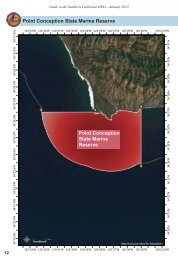
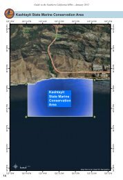
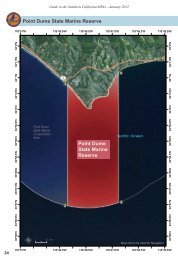
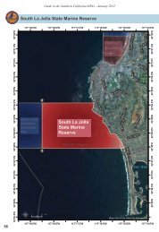
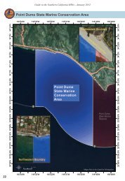
Guide to the Southern <strong>California</strong> <strong>MPA</strong>s - January 2012<br />
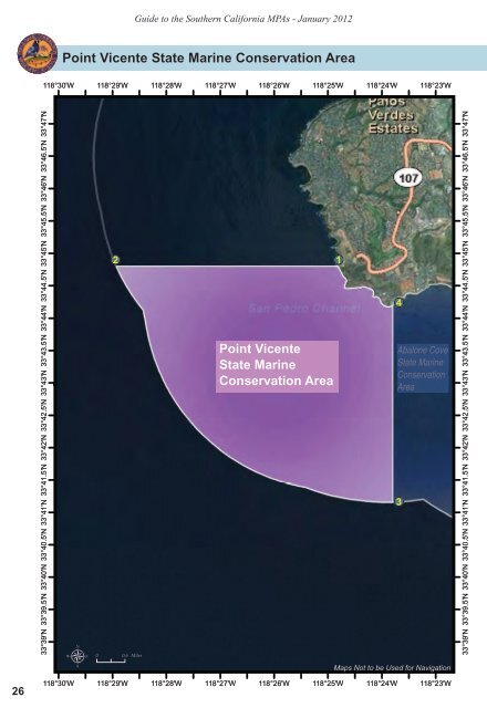
<strong>Point</strong> <strong>Vicente</strong> State Marine Conservation Area<br />
118°30'W<br />
118°29'W<br />
118°28'W<br />
118°27'W<br />
118°26'W<br />
118°25'W<br />
118°24'W<br />
118°23'W<br />
33°45'N 33°45.5'N 33°46'N 33°46.5'N 33°47'N<br />
2 1<br />
33°45'N 33°45.5'N 33°46'N 33°46.5'N 33°47'N<br />
33°44'N 33°44.5'N<br />
4<br />
33°44'N 33°44.5'N<br />
33°43'N 33°43.5'N<br />
<strong>Point</strong> <strong>Vicente</strong><br />
State Marine<br />
Conservation Area<br />
Abalone Cove<br />
State Marine<br />
Conservation<br />
Area<br />
33°42'N<br />
33°42'N<br />
33°42.5'N<br />
33°42.5'N<br />
33°43'N 33°43.5'N<br />
33°41'N 33°41.5'N<br />
3<br />
33°39.5'N<br />
33°39.5'N<br />
33°40'N<br />
33°40'N<br />
33°40.5'N<br />
33°41'N 33°41.5'N<br />
33°39'N<br />
33°40.5'N<br />
µ<br />
0<br />
0.6 Miles<br />
<strong>Map</strong>s Not to be Used for Navigation<br />
33°39'N<br />
26<br />
118°30'W<br />
118°29'W<br />
118°28'W<br />
118°27'W<br />
118°26'W<br />
118°25'W<br />
118°24'W<br />
118°23'W
Guide to the Southern <strong>California</strong> <strong>MPA</strong>s - January 2012<br />
<strong>Point</strong> <strong>Vicente</strong> State Marine Conservation Area<br />
Boundary and Regulations from <strong>California</strong> Code <strong>of</strong><br />
Regulations Title 14, Section 632 subsection (b)(97)<br />
Boundary:<br />
(A) This area is bounded by the mean high tide line and straight lines<br />
connecting the following points in the order listed except where noted:<br />
33° 44.80’ N. lat. 118° 24.82’ W. long. 1 ;<br />
33° 44.80’ N. lat. 118° 28.93’ W. long. 2 ; thence southeastward along<br />
the three nautical mile <strong>of</strong>fshore boundary to<br />
33° 41.16’ N. lat. 118° 23.80’ W. long. 3 ; and<br />
33° 44.19’ N. lat. 118° 23.80’ W. long. 4<br />
Permitted/Prohibited Uses:<br />
(B) Take <strong>of</strong> all living marine resources is prohibited, except for take<br />
pursuant to activities authorized under subsection 632(b)(97)(C).<br />
(C) Remediation activities associated with the Palos Verdes Shelf<br />
Operable Unit <strong>of</strong> the Montrose Chemical Superfund Site are allowed<br />
inside the conservation area pursuant to the Interim Record <strong>of</strong> Decision<br />
issued by the United States Environmental Protection Agency and any<br />
subsequent Records <strong>of</strong> Decision.<br />
Western Boundary<br />
Eastern Boundary<br />
Cielo <strong>Point</strong><br />
Pool<br />
Pacifica<br />
Del Mar<br />
Terranea<br />
Resort<br />
Long <strong>Point</strong><br />
Terranea Trail<br />
27