Map of Laguna Beach SMR - California MPA Educational Resources
Map of Laguna Beach SMR - California MPA Educational Resources
Map of Laguna Beach SMR - California MPA Educational Resources
- No tags were found...

You also want an ePaper? Increase the reach of your titles
YUMPU automatically turns print PDFs into web optimized ePapers that Google loves.
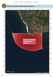
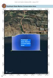
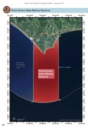
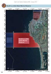
Guide to the Southern <strong>California</strong> <strong>MPA</strong>s - January 2012<br />
<strong>Laguna</strong> <strong>Beach</strong> State Marine Reserve<br />
117°50'W<br />
117°49'W<br />
117°48'W<br />
117°47'W<br />
117°46'W<br />
117°45'W<br />
33°34'N<br />
33°34.5'N<br />
33°34.5'N<br />
33°35'N<br />
33°35'N<br />
33°33.5'N<br />
33°33'N<br />
Crystal<br />
Cove State<br />
Marine 1<br />
Conservation<br />
Area<br />
33°34'N<br />
33°33.5'N<br />
33°33'N<br />
33°32'N<br />
33°32.5'N<br />
33°31.5'N<br />
33°32.5'N<br />
<strong>Laguna</strong> <strong>Beach</strong><br />
State Marine<br />
Reserve<br />
33°32'N<br />
33°31.5'N<br />
33°30.5'N 33°31'N<br />
2<br />
<strong>Laguna</strong> <strong>Beach</strong><br />
State Marine Conservation Area<br />
(no-take)<br />
3<br />
33°30.5'N 33°31'N<br />
33°29.5'N 33°30'N<br />
Dana Point<br />
State Marine<br />
Conservation<br />
Area<br />
33°29.5'N 33°30'N<br />
33°29'N<br />
µ<br />
0<br />
0.5 Miles<br />
<strong>Map</strong>s Not to be Used for Navigation<br />
33°29'N<br />
38<br />
117°50'W<br />
117°49'W<br />
117°48'W<br />
117°47'W<br />
117°46'W<br />
117°45'W
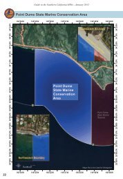
Guide to the Southern <strong>California</strong> <strong>MPA</strong>s - January 2012<br />
<strong>Laguna</strong> <strong>Beach</strong> State Marine Reserve<br />
Boundary and Regulations from <strong>California</strong> Code <strong>of</strong><br />
Regulations Title 14, Section 632 subsection (b)(112)<br />
Boundary:<br />
(A) This area is bounded by the mean high tide line and straight lines<br />
connecting the following points in the order listed:<br />
33° 33.233’ N. lat. 117° 49.200’ W. long. 1 ;<br />
33° 30.800’ N. lat. 117° 49.200’ W. long. 2 ; and<br />
33° 30.800’ N. lat. 117° 45.631’ W. long. 3<br />
Permitted/Prohibited Uses:<br />
(B) Take <strong>of</strong> all living marine resources is prohibited.<br />
Pacific Drive<br />
Monte Carlo Drive<br />
Northern Boundary<br />
Southern Boundary<br />
39