33°56.5'N 33°56.5'N µ
Point Dume State Marine Conservation Area - California MPA ...
Point Dume State Marine Conservation Area - California MPA ...
- No tags were found...

You also want an ePaper? Increase the reach of your titles
YUMPU automatically turns print PDFs into web optimized ePapers that Google loves.
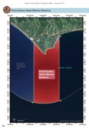
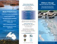
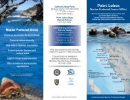
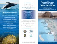
Guide to the Southern California MPAs - January 2012<br />
Point Dume State Marine Conservation Area<br />
118°54'W<br />
118°53'W<br />
118°52'W<br />
118°51'W<br />
118°50'W<br />
118°49'W<br />
118°48'W<br />
34°3.5'N<br />
Southeastern Boundary<br />
34°1.5'N<br />
34°3.5'N<br />
34°1.5'N<br />
34°2'N<br />
34°2.5'N<br />
34°2'N<br />
34°3'N<br />
34°3'N<br />
1<br />
Pacific Coast Highway<br />
Zuma Beach County Park<br />
Westward Beach Rd.<br />
34°2.5'N<br />
33°58.5'N 33°59'N 33°59.5'N 34°0'N 34°0.5'N 34°1'N<br />
2<br />
Point Dume<br />
State Marine<br />
Conservation<br />
Area<br />
4<br />
Point Dume<br />
State Marine<br />
Reserve<br />
33°57.5'N<br />
33°57.5'N<br />
33°58'N<br />
33°58'N<br />
33°58.5'N 33°59'N 33°59.5'N 34°0'N 34°0.5'N 34°1'N<br />
33°57'N<br />
3<br />
33°57'N<br />
<strong>33°56.5'N</strong><br />
33°56'N<br />
Northwestern Boundary<br />
<strong>µ</strong><br />
0 0.6 Miles<br />
Maps Not to be Used for Navigation<br />
<strong>33°56.5'N</strong><br />
33°56'N<br />
22<br />
118°54'W<br />
118°53'W<br />
118°52'W<br />
118°51'W<br />
118°50'W<br />
118°49'W<br />
118°48'W
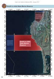
Guide to the Southern California MPAs - January 2012<br />
Point Dume State Marine Conservation Area<br />
Boundary and Regulations from California Code of<br />
Regulations Title 14, Section 632 subsection (b)(95)<br />
Boundary:<br />
(A) This area is bounded by the mean high tide line and straight lines<br />
connecting the following points in the order listed except where noted:<br />
34° 02.28’ N. lat. 118° 53.00’ W. long. 1 ;<br />
33° 59.14’ N. lat. 118° 53.00’ W. long. 2 ; thence southeastward along<br />
the three nautical mile offshore boundary to<br />
33° 56.96’ N. lat. 118° 49.20’ W. long. 3 ; and<br />
34° 00.76’ N. lat. 118° 49.20’ W. long. 4<br />
Permitted/Prohibited Uses:<br />
(B) Take of all living marine resources is prohibited except:<br />
1. The recreational take of pelagic finfish* [subsection 632(a)(3)],<br />
including Pacific bonito, and white seabass by spearfishing [Section<br />
1.76] is allowed.<br />
2. The commercial take of coastal pelagic species** [Section 1.39] by<br />
round haul net [Section 8750, Fish and Game Code] and swordfish by<br />
harpoon [subsection 107(f)(1)] is allowed.<br />
3. Take pursuant to activities authorized under subsection 632(b)(95)<br />
(C) is allowed.<br />
(C) Beach nourishment and other sediment management activities are<br />
allowed inside the conservation area pursuant to any required federal,<br />
state and local permits, or as otherwise authorized by the Department.<br />
*Pelagic finfish are defined here as: northern anchovy (Engraulis mordax),<br />
barracudas (Sphyraena spp.), billfishes (family lstiophoriade), dolphinfish<br />
(Coryphaena hippurus), Pacific herring (Clupea pallasii), jack mackerel (Trachurus<br />
symmetricus), Pacific mackerel (Scomber japonicus), salmon (Oncorhynchus spp.),<br />
Pacific sardine (Sardinops sagax), blue shark (Prionace glauca), salmon shark<br />
(Lamna ditropis), shortfin mako shark (lsurus oxyrinchus), thresher sharks (Alopias<br />
spp.), swordfish (Xiphias gladius), tunas (family Scombridae), and yellowtail<br />
(Seriola lalandi). The commercial take of marlin is not allowed.<br />
** Coastal pelagic species are defined here as: northern anchovy (Engraulis<br />
mordax), Pacific sardine (Sardinops sagax), Pacific mackerel (Scomber japonicus),<br />
jack mackerel (Trachurus symmetricus) and market squid (Loligo opalescens).<br />
23