CAERT-THRESOOR
Aflevering / Issue 2 - Caert-Thresoor
Aflevering / Issue 2 - Caert-Thresoor

You also want an ePaper? Increase the reach of your titles
YUMPU automatically turns print PDFs into web optimized ePapers that Google loves.
of the topographical drawings in the British Museum, vol,<br />
III. London 1861, blz. 195: 'A chart of the coast of Flanders<br />
and Holland, from Calais to the Ems, with the courses of<br />
the Scheld, Meuse, Rhine, and Ems'.<br />
9. Doursther, H., Dictionnaire universel des poids et mesures<br />
anciens et modernes. Reprint Amsterdam, 1965, blz. 279-<br />
10. Delano-Smith, C. en R.J.P. Kain, English Maps: A History<br />
(The British Library Studies in Map History, vol. II).<br />
London, 1999, blz. 66.<br />
11. Voor een herhaalde discussie dank ik nogmaals Catherine<br />
Delano-Smith (Londen).<br />
12. Smit, E. en J. Zweers, Der Erwerb Gelderns als Beweggrund<br />
für die Heirat zwischen Anna von Kleve und<br />
Heinrich VIII. von England. In: Land im Mittelpunkt der<br />
Mächte. Die Herzogtümer Jülich-Kleve-Berg. Kleve, 1984,<br />
blz. 147-152.<br />
13- Van der Heijden, op. cit., Kaarten der Nederlanden, blz.<br />
135 (Type A).<br />
14. Enkele speculaties hierbij: A.W. Lang, Traces of lost<br />
European sea charts of the 15th century, in: Imago Mundi<br />
12, 1955, blz. 31^4.<br />
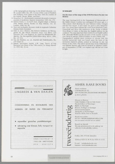
SUMMARY<br />
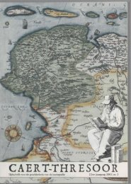
On the trace of the map of the XVII Provinces by Jan van<br />
Hoirne<br />
The map Cott.Aug.I.ii.63 in the Department of Manuscripts of<br />
the British Library, London was catalogued 150 years ago as a<br />
l6th century chart showing the area between Calais, Cologne<br />
and the Ems mouth. A new study has given a new interpretation.<br />
Two dotted lines indicate the routes from Hambach Castle,<br />
Düsseldorf and Cleve (the residences of the Duchy of Jülich-<br />
Cleve-Berg) to Calais, at that time the English harbour on the<br />
continent. The map may have been drawn by an English author<br />
R.W. (Reynold Wolfe?) on the occasion of the journey of Anna<br />
von Cleves in autumn 1539 to London, to marry Henry VIII.<br />
Topographical analysis gives evidence to assume that this<br />
London manuscript map was based upon the basis of the<br />
Germania Inférions tabula, printed in Antwerp by Jan van<br />
Hoirne in the 1520s. This oldest special map of the Netherlands<br />
was hitherto known only from its mention in Ortelius's catalogue<br />
of mapmakers (1570ff.); an original copy still has not come<br />
to light.<br />
PAPIERRESTAURATIE<br />
1 " '" 1<br />
LINGBEEK & VAN DA ALEN<br />
ASHER RARE BOOKS<br />
Zojuist verschenen:<br />
CATALOGUS 32:<br />
205 OUDE EN ZELDZAME BOEKEN<br />
op diverse gebieden:<br />
CONSERVERING EN RESTAURATIE VAN<br />
WERKEN OP PAPIER EN PERKAMENT<br />
• aquarellen gouaches pasteltekeningen<br />
• advisering over klimaat, licht, transport en<br />
expositie<br />
ÖJD<br />
Atlassen en Kaarten<br />
Oude Drukken (15de en 16de Eeuw)<br />
Handschriftten en Tekeningen<br />
Bijbels en Theologie<br />
Botanie, Zoölogie en Geologie<br />
Natuurwetenschappen<br />
Topografie en Reisverslagen<br />
Amerika, Afrika, Azië en Australië<br />
Bezoek onze website:<br />
HTTP://WWW.ASHERBOOKS.COM<br />
voor een actueel overzicht van ons aanbod.<br />
Bezoek op afspraak.<br />
Wij zijn geïnteresseerd in de aankoop van<br />
collecties of afzonderlijke stukken.<br />
AMALIASTRAAT 5<br />
1 052 GM AMSTERDAM<br />
020 - 6 8 4 1 0 7 4<br />
Postbus 258,1970 AG IJmuiden<br />
Telefoon: 0255 52 38 39, fax: 0255 51 03 52<br />
E-mail: info@asherbooks.com<br />
Internet: www.asherbooks.com<br />
40<br />
<strong>CAERT</strong>-<strong>THRESOOR</strong><br />
21ste jaargang 2002, nr. 2