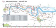
THE VIRGIN LONDON MARATHON COURSE
Road closures (PDF) - Virgin London Marathon
Road closures (PDF) - Virgin London Marathon

You also want an ePaper? Increase the reach of your titles
YUMPU automatically turns print PDFs into web optimized ePapers that Google loves.
Local Information for residents enclosed by the route:<br />
Rotherhithe<br />
Special arrangements will be in place for the residents of Rotherhithe<br />
peninsular (mile 9 to mile 11) to exit and enter the peninsular while the road<br />
closures are in place.<br />
Wapping<br />
Residents of Wapping are enclosed by the route as it passes along<br />
The Highway between miles 13 to 14 and again on the opposite<br />
carriageway between miles 21 to 22.<br />
Bacon’s College in Timber Pond Lane will provide a free, secure,<br />
overnight parking facility on their premises for use by local residents.<br />
The car park will be in operation from 4:00pm on Saturday 21 st April until<br />
4:00pm on Sunday 22 nd April.<br />
Residents can leave their cars securely parked and can return on foot at any<br />
time while the road closures are in place to collect vehicles for exit off of<br />
the Peninsular. From the College, the route is Timber Pond Road, Poolmans<br />
Street, Needleman Street, Surrey Quays Road, Lower Road and Jamaica<br />
Road (westbound). Note that Jamaica Road will be reduced to one<br />
lane outside Bermondsey Station.<br />
The Bishop Challoner School will provide a free, secure, overnight<br />
parking facility on their premises for use by local residents. The car<br />
park will be in operation from 4:00pm on Saturday 21 st April until<br />
4:00pm on Sunday 22 nd April. Access to the School is via Commercial<br />
Road and Steels Lane.<br />
Residents can leave their cars securely parked and can return on<br />
foot at any time while the road closures are in place to collect<br />
vehicles for exit to the north via Commercial Road, open eastbound<br />
and westbound. Residents are advised to use the pedestrian<br />
subway at the junction of The Highway and Glamis Road.<br />
Residents requiring access should use Hawkstone Road, Lower Road,<br />
Surrey Quays Road, Needleman Street, Poolmans Street and Timber Pond<br />
Road and may leave their cars at the College until the roads reopen.<br />
<strong>THE</strong> <strong>VIRGIN</strong> <strong>LONDON</strong><br />
<strong>MARATHON</strong> <strong>COURSE</strong><br />
Vehicle Removals<br />
If you live on one of the roads on the route, please<br />
help by parking your vehicle off of the route either on<br />
Saturday evening 21 st April or bef ore 07:00 Sunday<br />
22 nd April. Vehicle removals on the whole route will start<br />
from 07:00am on Sunday 22 nd April. Please ensure that<br />
your car is parked off of the Marathon route prior to<br />
this time. We do appreciate your support - runners and<br />
wheelchair competitors are vulnerable to parked cars.<br />
The London Marathon Ltd is a subsidiary of the London<br />
Marathon Charitable Trust - a Registered Charity<br />
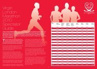
expected time of elite women<br />
09:00<br />
09:05 09:10 09:15 09:21 09:26 09:31 09:36 09:42 09:47 09:52 09:57 10:03 10:08<br />
09:45 09:49 09:54 09:59 10:04 10:09 10:13 10:18 10:23 10:28 10:33 10:37 10:42 10:47<br />
expected time of elite MEN
In addition, a vehicle crossing point will operate while the road<br />
closures are in place at the junction of The Highway and Glamis<br />
Road, allowing entry and exit north and south. Residents are<br />
advised that while there are runners on both carriageways of The<br />
Highway (between approximately 10:00am and 1:30pm) it will NOT<br />
be possible for vehicles to cross.<br />
Isle of Dogs (mile 16 to mile 19)<br />
There will be exit off of the Island for residents as follows:<br />
Residents on the river side of Westferry Road will be able to use<br />
the single lane access route southbound on Westferry Road to<br />
the junction of East Ferry Road and Manchester Road, then on<br />
to Preston’s Road, Aspen Way (eastbound) and Leamouth Road.<br />
Motorists must proceed with caution as there will be runners on the<br />
southbound carriageway of Westferry Road. Instructions of<br />
stewards and Police must be followed at all times.<br />
stewards and Police at these crossing points must be followed at<br />
all times. Residents should note that while the race is in progress,<br />
vehicle exit will be slow and safety of runners is paramount. There<br />
will be RESTRICTED ACCESS onto the Island until the roads reopen<br />
after the event<br />
The Greenwich Foot Tunnel<br />
The Greenwich Foot Tunnel will be open. It will be busy crossing<br />
south to north, expect to queue. The Foot Tunnel will be closed<br />
north to south between 10.30am to 12.30pm, alternative<br />
arrangements in place on DLR from Island Gardens.<br />
Residents within the area enclosed by Marsh Wall, East Ferry Road<br />
and Westferry Road will be able to exit via the vehicle crossing<br />
points at Byng Street and Spindrift Avenue. Instructions of the<br />
Official Race Broadcasters to the<br />
Virgin London Marathon<br />
10:13 10:19 10:24 10:29 10:34 10:40 10:45 10:50 10:55 11:01 11:06 11:11 11:16 11:18<br />
10:52 10:57 11:01 11:06 11:11 11:16 11:21 11:25 11:30 11:35 11:40 11:45 11:49 11:51<br />
Distributed by South London Leaflets
Mile Main Road Anticipated Anticipated<br />
on Route Closure Opening<br />
Red Start Charlton Way 07.00 12.00<br />
Blue Start Shooters Hill Road 07.00 12.00<br />
1 Red Route: Charlton Road 07.00 12.00<br />
Blue Route: Shooters Hill Road 07.00 12.00<br />
2 Red Route: Little Heath 07.00 12.00<br />
Blue Route: Charlton Park Lane 07.00 12.00<br />
3 Red Route: Artillery Place 07.00 12.00<br />
Blue Route: John Wilson Street 07.00 12.00<br />
4 Woolwich Church Street 07.00 14.00<br />
5 Woolwich Road 07.00 14.00<br />
6 Trafalgar Road 07.00 14.00<br />
7 Creek Road 07.00 14.00<br />
8 Evelyn Street 08.00 14.00<br />
9 Surrey Quays Road 08.00 16.00<br />
10 Salter Road 08.00 16.00<br />
11 Brunel Road 08.00 16.00<br />
12 Jamaica Road 08.00 16.00<br />
12.5 Tower Bridge 08.00 19.00<br />
14 The Highway (south side) 08.00 19.00<br />
14.5 Narrow Street 08.00 19.00<br />
15 Westferry Road 08.00 19.00<br />
16 Westferry Road 08.00 19.00<br />
17 East Ferry Road 08.00 19.00<br />
18 Marsh Wall 08.00 19.00<br />
19 North Colonnade 08.00 19.00<br />
20 Poplar High Street 08.00 19.00<br />
21 Commercial Road 08.00 19.00<br />
22 The Highway (north side) 08.00 19.00<br />
23 Byward Street 08.00 19.00<br />
24 Upper Thames Street 08.00 19.00<br />
25 Victoria Embankment 07.00 19.00<br />
26 Birdcage Walk 07.00 19.00<br />
Please note that all reopening times are approximate. Roads will be reopened when it is safe to do so - these times should be used as a<br />
guide as the latest that the roads will reopen.<br />
Vehicle Crossing Points (For residents and drop offs)<br />
Road closures will be in place around the Blackheath, Woolwich, Greenwich and Westminster areas from 07:00am. Residents will be facilitated across the route at the identified crossing points –<br />
(BUT NOT to travel along the route) until the times as shown for each crossing point below.<br />
These may close earlier if directed by Police or the Marathon Forward Command Vehicle.<br />
Charlton Road / Victoria Way / Marlborough Lane. (Until 08:45 am) Crossing over Charlton Road (North and South).<br />
Shooter’s Hill Rd / Kenya Road / Weyman Road. (Until 08:45 am) Crossing over Shooters Hill Road (North and South).<br />
Ha -Ha Road / Stadium Road / Repository Road. (Until 08:45 am) Crossing over Ha-Ha Road (North and South).<br />
Artillery Place / Repository Road / Frances Street. (Until 08:45 am) Crossing over Artillery Place (North and South).<br />
Woolwich Road / Frances Street / Leda Road. (Until 08:45 am) Crossing over Woolwich Road (North and South)<br />
Woolwich Road / Anchor & Hope Lane / Charlton Church Lane. (Until 09:00 am) Crossing over Woolwich Road (North and South)<br />
Trafalgar Road / Blackwall Lane / Vanbrugh Hill. (Until 09:05 am) Crossing over Trafalgar Road (North and South)<br />
Creek Road / Norman Road / Norway Street. (Until 09:15 am) Crossing over Creek Road (North and South)<br />
Creek Road / Glaisher Street / Gonson Street / Creekside. (Until 09:15 am) Crossing over Creek Road (North and South)<br />
Note: HaHa Road will be<br />
closed to vehicles AND<br />
pedestrians between the<br />
junctions of Repository Road<br />
and Woolwich Common Road<br />
from 15th April 2012 for the<br />
Olympic shooting test event.<br />
From 08:00am the remainder of the Road Closures will take place through Deptford, Rotherhithe, Tower Hamlets, Docklands and the City. Residents will be facilitated across the route at the identified<br />
crossing points – (BUT NOT to travel along the route) until the times as shown for each crossing point below.<br />
Creek Road / Deptford High Street / Watergate Street. (Until 09:15 am) Crossing over Creek Road (North and South)<br />
Evelyn Street / Abinger Grove / Grove Street / Princes Street (Until 09:20 am) Crossing over Evelyn Street (North and South). Allows Pepys Estate, and Plough Way area in and out.<br />
Lower Road / Plough Way (Until 09:30 am) Crossing over Lower Road (South Only)<br />
Redriff Road / Deal Porters Way / Worgan Street (Until 09:30 am) Crossing over Redriff Road (Allows Osprey Estate & Worgan Street Residents in and out)<br />
Salter Road / Rotherhithe Street / Lagado Mews (Until 09:30 am) Crossing Salter Road (North and South) Allows Rotherhithe Street residents in and out.<br />
Brunel Road / Cannon Beck Road (Until 09:30 am) Crossing Brunel Road (East and West)<br />
Jamaica Road / West Lane / Southwark Park Road (Until 09:30 am) Crossing Jamaica Road (North and South)<br />
Jamaica Road / Bevington Street / St James’s Road (Until 09:30 am) Crossing Jamaica Road (North and South)<br />
Jamaica Road / Dockhead / Mill Street (until 09:30 am Crossing Jamaica Road (North and South)<br />
Jamaica Road / Shad Thames / Tanner Street (Until 09:30 am) Crossing Jamaica Road.<br />
The Highway / Glamis Road (until 10:00 am then again from approx 1:30 pm) Controlled by London Marathon marshals Crossing The Highway (North and South)<br />
Limehouse Causeway / Three Colt Street (Until 10:00 am) Crossing Limehouse Causeway (North and South) Out via Gill Street into Commercial Road Eastbound<br />
Commercial Road / Gill Street / Three Colt Street (Until 10:00 am) Crossing Commercial Road (assisted Into Eastbound)<br />
Please note:<br />
The 2013<br />
Virgin<br />
London<br />
Marathon<br />
will be<br />
held on<br />
Sunday<br />
21st April<br />
Westferry Road / Byng Street (Facilitated Out All Day) Managed and Controlled by London Marathon marshals. Vehicle Exit point from Byng Street across into Westferry Road Southbound.<br />
Westferry Road / Spindrift Avenue (Facilitated Out All Day) Managed and Controlled by London Marathon marshals. Vehicle Exit point from Spindrift Avenue across into Westferry Road<br />
Southbound.<br />
Commercial Road / Basin Approach (Until 10:30 am) (Allows Limehouse Basin residents access.) Crossing Commercial Road into Eastbound Lane.<br />
Commercial Road / Tunnel Approach (Until 10:30 am) Crossing Commercial Road into Eastbound (Allows Branch Road and Limehouse Basin Residents access)<br />
Once the Crossing Points are closed, drivers will not be permitted to cross the route, this may be earlier than the times above if directed by Police or the Marathon Forward Command Vehicle. This ‘total<br />
closure’ will remain in force until the marathon Rear Command vehicle passes or when directed by Police, whereby drivers will be permitted to cross the route only.<br />
The reopening of the vehicle Crossing Points will be as soon as safe to do so.