Cameron - Pennsylvania Natural Heritage Program
Cameron - Pennsylvania Natural Heritage Program Cameron - Pennsylvania Natural Heritage Program
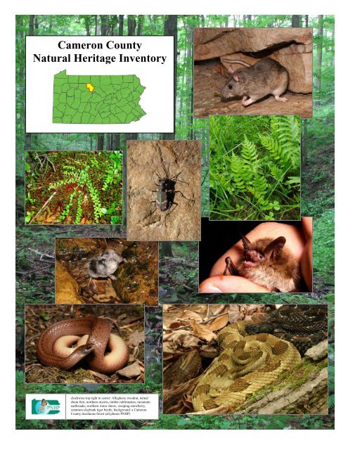
Cameron CountyNatural Heritage Inventoryclockwise-top right to center: Allegheny woodrat, nettedchain fern, northern myotis, timber rattlesnakes, mountainearthsnake, northern water shrew, creeping snowberry,common claybank tiger beetle, background: a CameronCounty deciduous forest (all photos PNHP)
- Page 2 and 3: CAMERON COUNTYNATURAL HERITAGE INVE
- Page 4 and 5: PREFACEThe Pennsylvania Natural Her
- Page 6 and 7: ACKNOWLEDGEMENTSWe would like to ac
- Page 8 and 9: How to use this documentThe Cameron
- Page 10 and 11: EXECUTIVE SUMMARYPrefaceThe ability
- Page 12 and 13: Natural Heritage Areas & Conservati
- Page 14 and 15: highlighting the large forested blo
- Page 16 and 17: A Final Note on Rare, Threatened, a
- Page 18 and 19: local zoning and land use regulatio
- Page 20 and 21: Watersheds or subwatersheds where n
- Page 22 and 23: Table 3. Natural Heritage Areas cat
- Page 24 and 25: Notable (continued)Ridgeline west o
- Page 26 and 27: RICH VALLEYWEST CREEKCAMERONSINNEMA
- Page 28 and 29: een lost entirely since European se
- Page 30 and 31: Pennsylvania, Cameron County had it
- Page 32 and 33: epresentative of habitats that are
- Page 34 and 35: Cameron County lies entirely within
- Page 36 and 37: VegetationThe interaction of geolog
- Page 38 and 39: Graminoid marshes are wetlands domi
- Page 40 and 41: In addition to naturally vegetated
- Page 42 and 43: difficulty in assessing how beavers
- Page 44 and 45: may be isolated by inhospitable, xe
- Page 46 and 47: Invasive Species in Cameron CountyN
- Page 48 and 49: Invasive Animal SpeciesIn addition
- Page 50 and 51: Feral swine (Sus scrofa), also call
<strong>Cameron</strong> County<strong>Natural</strong> <strong>Heritage</strong> Inventoryclockwise-top right to center: Allegheny woodrat, nettedchain fern, northern myotis, timber rattlesnakes, mountainearthsnake, northern water shrew, creeping snowberry,common claybank tiger beetle, background: a <strong>Cameron</strong>County deciduous forest (all photos PNHP)
CAMERON COUNTYNATURAL HERITAGE INVENTORY2012Prepared for:<strong>Cameron</strong> County Planning Commission20 East 5th StreetEmporium, PA 15834(814)486-9322Prepared by:<strong>Pennsylvania</strong> <strong>Natural</strong> <strong>Heritage</strong> <strong>Program</strong>Western <strong>Pennsylvania</strong> Conservancy208 Airport DriveMiddletown, PA 17057(717) 948-3962This project was funded through grants provided by the DCNR Wild Resource Conservation <strong>Program</strong> (WRCP).Copies of this report are available in electronic format through the <strong>Pennsylvania</strong> <strong>Natural</strong> <strong>Heritage</strong><strong>Program</strong> website, www.naturalheritage.state.pa.us, and through the <strong>Cameron</strong> County PlanningCommission.This reference may be cited as:<strong>Pennsylvania</strong> <strong>Natural</strong> <strong>Heritage</strong> <strong>Program</strong>. 2012. <strong>Cameron</strong> County <strong>Natural</strong> <strong>Heritage</strong> Inventory.Western <strong>Pennsylvania</strong> Conservancy. Middletown, PA.ii<strong>Cameron</strong> County <strong>Natural</strong> <strong>Heritage</strong> Inventory
Charlie Eichelberger (PNHP)A pair of combating male timber rattlesnakes (Crotalus horridus) in <strong>Cameron</strong> County. When a female is receptive totwo similarly sized male snakes, the males will compete by raising their heads high into the air and then attemptingto pin the opponent to the ground. Sometimes lasting several hours, these competitions end when one snake clearlyshows dominance, and the loser moves off.iii<strong>Cameron</strong> County <strong>Natural</strong> <strong>Heritage</strong> Inventory – Preface
PREFACEThe <strong>Pennsylvania</strong> <strong>Natural</strong> <strong>Heritage</strong> <strong>Program</strong> (PNHP) is a partnership between the Western <strong>Pennsylvania</strong>Conservancy (WPC), the <strong>Pennsylvania</strong> Department of Conservation and <strong>Natural</strong> Resources (DCNR), the<strong>Pennsylvania</strong> Game Commission (PGC), and the <strong>Pennsylvania</strong> Fish and Boat Commission (PFBC).PNHP is a member of NatureServe, which coordinates natural heritage efforts through an internationalnetwork of member programs-known as natural heritage programs, or conservation data centers, operatingin all 50 U.S. states, Canada, Latin America, and the Caribbean. The <strong>Pennsylvania</strong> <strong>Natural</strong> <strong>Heritage</strong><strong>Program</strong> is responsible for collecting, tracking, and interpreting the information regarding theCommonwealth’s biological diversity. County <strong>Natural</strong> <strong>Heritage</strong> Inventories (CNHIs) are an importantpart of the work of the PNHP. Since 1988, the PNHP has conducted CNHIs as a means to both gathernew information about natural resources and to pass this information along to those responsible formaking decisions about the resources in the county. The <strong>Cameron</strong> CNHI focuses on the best examples ofliving ecological resources within the county. Historic, cultural, educational, water supply, agriculturaland scenic resources should be addressed through other projects and programs. Although the CNHI wasconducted using a tested and proven methodology, it is best viewed as a preliminary report on thecounty’s natural heritage. Further investigations could, and likely will, uncover previously unidentifiedareas of significance. Likewise, in-depth investigations of sites listed in this report could reveal featuresof further or greater significance than have been documented. We encourage additional inventory workacross the county to further the efforts begun with this study. Keep in mind that there will be more placesto add to those identified within this report and that this document can be updated as necessary toaccommodate new information.Consider this inventory as an invitation for the people of <strong>Cameron</strong> County to explore and discuss theirnatural heritage and to learn about and participate in the conservation of the living ecological resources ofthe county. Ultimately, it will be up to the landowners, residents, and officials of <strong>Cameron</strong> County todetermine how to use this information. Several of the CNHIs potential applications for a number of usergroups follow:Planners and Government Staff: Typically, the planning office in a county administers county inventoryprojects. Often, the inventories are used in conjunction with other resource information (agriculturalareas, slope and soil overlays, floodplain maps, etc.) in review for various projects and in comprehensiveplanning. <strong>Natural</strong> <strong>Heritage</strong> Areas may be included under various categories of zoning, such asconservation or forest zones, within parks and greenways, and even within agricultural security areas.There are many possibilities to provide for the conservation of <strong>Natural</strong> <strong>Heritage</strong> Areas within the contextof public amenities, recreational opportunities, and resource management.County, State, and Federal Agencies: In many counties, <strong>Natural</strong> <strong>Heritage</strong> Areas lie within or includecounty, state, or federal lands. Agencies such as the <strong>Pennsylvania</strong> Game Commission (PGC), theDepartment of Conservation and <strong>Natural</strong> Resources (DCNR), and the Army Corps of Engineers(USACE) can use the inventory to understand the extent of the resource. Agencies can also learn therequirements of the individual plant, animal or community elements, and the general approach thatprotection could assume. County Conservation Districts may use the inventories to focus attention onresources (high diversity streams or wetlands) and as a reference in encouraging good managementpractices.Environmental and Development Consultants: Environmental consultants are called upon to plan for amultitude of development projects including road construction, housing developments, commercialenterprises, and infrastructure expansion. Design of these projects requires that all the resources impactedbe known and understood. Decisions made with inadequate information can lead to substantial and costlyiv<strong>Cameron</strong> County <strong>Natural</strong> <strong>Heritage</strong> Inventory – Preface
delays. County <strong>Natural</strong> <strong>Heritage</strong> Inventories (CNHIs) provide a first look at biological resources,including plants and animals listed as rare, threatened, or endangered in <strong>Pennsylvania</strong> and/or at the federallevel. Consultants can then see potential conflicts long before establishing footprints or developingdetailed plans and before applying for permits. This allows projects to be changed early on whenflexibility is at a maximum.Environmental consultants are increasingly called upon to produce resource plans (e.g. RiverConservation Plans, Parks and Open Space Plans, and Greenways Plans) that must integrate a variety ofbiological, physical, and social information. CNHIs can help define priorities for conservation and areoften used as the framework for these plans.Developers: Working with environmental consultants, developers can consider options for developmentthat add value while protecting key resources. Incorporating green-space, wetlands, and forest buffersinto various kinds of development can attract homeowners and businesses that desire to have naturalamenities nearby. Just as parks have traditionally raised property values, so too can natural areas. CNHIscan suggest opportunities where development and conservation can complement one another.Educators: Curricula in primary, secondary, and college level classes often focus on biological science atthe chemical or microbiological level. Field sciences do not always receive the attention that theydeserve. <strong>Natural</strong> areas can provide unique opportunities for students to witness, first-hand, the organismsand natural communities that are critical to maintaining biological diversity. Teachers can use CNHIs toshow students where and why local and regional diversity occurs, and to aid in curriculum developmentfor environment and ecology academic standards. With proper permission and arrangements throughlandowners and the <strong>Pennsylvania</strong> <strong>Natural</strong> <strong>Heritage</strong> <strong>Program</strong>, students can visit <strong>Natural</strong> <strong>Heritage</strong> Areasand establish appropriate research or monitoring projects.Conservation Organizations: Organizations that have mission related to the conservation of biologicaldiversity can turn to the inventory as a source of prioritized places in the county. Such a reference canhelp guide internal planning and define the essential resources that can be the focus of protection efforts.Land trusts and conservancies throughout <strong>Pennsylvania</strong> have made use of the inventories to do just thissort of planning and prioritization, and are now engaged in conservation efforts on highly significant sitesin individual counties and regions.County <strong>Natural</strong> <strong>Heritage</strong> Inventories and environmental reviewThe results presented in this report represent a snapshot in time, highlighting the sensitive natural areas within<strong>Cameron</strong> County. The sites in the <strong>Cameron</strong> County <strong>Natural</strong> <strong>Heritage</strong> Inventory have been identified to helpguide land use and county planning. The <strong>Cameron</strong> County <strong>Natural</strong> <strong>Heritage</strong> Inventory is a planning tool, butis not a substitute for the environmental review process (PNDI), as information is constantly being updated asnatural resources are both destroyed and discovered. Applicants for building permits and planningcommissions can conduct free, online, environmental reviews to inform them of project-specific potentialconflicts with sensitive natural resources. Environmental reviews can be conducted by visiting the<strong>Pennsylvania</strong> <strong>Natural</strong> <strong>Heritage</strong> <strong>Program</strong>’s website, at http://www.naturalheritage.state.pa.us/. If conflicts arenoted during the environmental review process, the applicant is informed of the steps to take to minimizenegative effects on the county’s sensitive natural resources. If additional information on species of concernbecomes available during environmental review, the review may be reconsidered by the jurisdictional agency.v<strong>Cameron</strong> County <strong>Natural</strong> <strong>Heritage</strong> Inventory – Preface
ACKNOWLEDGEMENTSWe would like to acknowledge the many citizens and landowners of the county and surrounding areaswho volunteered information, time, and effort to the inventory and granted permission to access land.We would also like to thank the <strong>Pennsylvania</strong> Department of Conservation and <strong>Natural</strong> Resources forproviding the funding to make this report possible. Special thanks goes to the people of <strong>Cameron</strong> Countyfor their interest and hospitality. A big thank you goes to those who suggested areas of interest andassisted with field surveys, including Lisa Bainey (DCNR), Randy Cassell, Jim Chestney (PFBC), JanetColwell, Jeff Colwell (PFBC), Bill Crisp (PFBC), Tom Diez, Bob Martin, Ralph Harrison, Tom Pluto,Joe Wilson, Matt Wilson, Jeanne Wambaugh (DCNR) and Jim Zoschg (CCCD).We want to recognize the <strong>Pennsylvania</strong> <strong>Natural</strong> <strong>Heritage</strong> <strong>Program</strong> and NatureServe for providing thefoundation for the work that we perform for these studies. Current and former PNHP staff thatcontributed to this report include JoAnn Albert, Karen Bosco, Jake Boyle, Kierstin Carlson, Tony Davis,Jeremy Deeds, Alice Doolittle, Rocky Gleason, Steve Grund, Jim Hart, Susan Klugman, Matt Kowalski,John Kunsman, Betsy Leppo, Beth Meyer, Ryan Miller, Sally Ray, Erika Schoen, Andrew Strassman,Christopher Tracey, Jeff Wagner, Mary Walsh, Denise Watts, Peter Woods, and Ephraim Zimmerman.Without the support and help from these people and organizations, the inventory would not have seencompletion. We encourage comments and questions. The success of the report will be measured by theuse it receives and the utility it serves to those making decisions about resources and land use throughoutthe county. Thank you for your interest.Charlie Eichelberger, Herpetologist<strong>Pennsylvania</strong> <strong>Natural</strong> <strong>Heritage</strong> <strong>Program</strong>vi<strong>Cameron</strong> County <strong>Natural</strong> <strong>Heritage</strong> Inventory – Preface
vii<strong>Cameron</strong> County <strong>Natural</strong> <strong>Heritage</strong> Inventory – Preface
How to use this documentThe <strong>Cameron</strong> County <strong>Natural</strong> <strong>Heritage</strong> Inventory is designed to provide information about the biodiversity of<strong>Cameron</strong> County. The Introduction of the report has an overview of the natural features and history of <strong>Cameron</strong>County and the Methods section has an overview of the process behind this inventory. Results are presented atthe broad landscape view, and then move into finer scale results which are broken down by municipality.Finally, the results are followed by some Conclusions and General Recommendations for <strong>Cameron</strong> County.TABLE OF CONTENTSACKNOWLEDGEMENTS ..........................................................................................................................viEXECUTIVE SUMMARY............................................................................................................................ xSITE INDEX MAP...............................................................................................................................xxviINTRODUCTION ......................................................................................................................................... 1OVERVIEW OF THE NATURAL FEATURES OF CAMERON COUNTY.............................................. 7Physiography and Geology........................................................................................................................ 7Soils........................................................................................................................................................... 9Vegetation ............................................................................................................................................... 10Forest Communities............................................................................................................................ 10Wetland Communities ......................................................................................................................... 11Flowing Water Systems........................................................................................................................... 13Watersheds.......................................................................................................................................... 13Disturbance.............................................................................................................................................. 15Landscape Scale Conservation ................................................................................................................ 17Invasive Species in <strong>Cameron</strong> County...................................................................................................... 20A REVIEW OF THE ANIMALS OF CAMERON COUNTY.................................................................... 27Mammals of <strong>Cameron</strong> County ................................................................................................................ 27Birds of <strong>Cameron</strong> County........................................................................................................................ 34Reptiles and Amphibians of <strong>Cameron</strong> County ........................................................................................ 37Fish of <strong>Cameron</strong> County ......................................................................................................................... 41Freshwater Mussels of <strong>Cameron</strong> County................................................................................................. 44Insects of <strong>Cameron</strong> County ..................................................................................................................... 46“Orphan Taxa” of <strong>Cameron</strong> County........................................................................................................ 49METHODS .................................................................................................................................................. 51Site Selection........................................................................................................................................... 51Ground Surveys....................................................................................................................................... 51Data Analysis and Mapping .................................................................................................................... 51RESULTS .................................................................................................................................................... 55Riparian Area Recommendations............................................................................................................ 57<strong>Natural</strong> <strong>Heritage</strong> Areas............................................................................................................................ 59Gibson Township and Driftwood Borough......................................................................................... 60Grove Township ................................................................................................................................. 71Lumber Township............................................................................................................................... 82Portage Township ............................................................................................................................... 90Shippen Township and Emporium Borough....................................................................................... 94CONCLUSIONS AND GENERAL RECOMMENDATIONS................................................................. 103GLOSSARY .............................................................................................................................................. 111REFERENCES AND LITERATURE CITED........................................................................................... 112GIS DATA SOURCES .............................................................................................................................. 120APPENDIX I: Species and <strong>Natural</strong> Communities of Conservation Concern in <strong>Cameron</strong> County ....... 121APPENDIX II: Federal and State Status, and <strong>Natural</strong> <strong>Heritage</strong> Ranks................................................. 122APPENDIX III: Sustainable Forestry Information Sources.................................................................. 126APPENDIX IV: Aquatic Invasive Species (AIS).................................................................................. 127APPENDIX V: ‘EasyEO’ form and instructions................................................................................... 128APPENDIX VI: PNHP Aquatic Community Classification (ACC) in <strong>Cameron</strong> County ..................... 130APPENDIX VII: Selected Fact Sheets.................................................................................................. 143viii<strong>Cameron</strong> County <strong>Natural</strong> <strong>Heritage</strong> Inventory – Table of Contents
TABLE OF FIGURESFigure 1. Core and Supporting Landscape designations................................................xiiFigure 2. Number of species of concern by municipality............................................. xivFigure 3. An overview of <strong>Cameron</strong> County’s infrastructure .......................................... 3Figure 4. Landcover distribution of <strong>Cameron</strong> County.................................................... 5Figure 5. Physiographic Provinces of <strong>Pennsylvania</strong>........................................................ 7Figure 6. <strong>Cameron</strong> County’s bedrock formations ........................................................... 8Figure 7. Soil Associations of <strong>Cameron</strong> County. ............................................................ 9Figure 8. Watersheds (HUC10) of <strong>Cameron</strong> County. .................................................. 13Figure 9. Forest and wetland areas of <strong>Pennsylvania</strong>..................................................... 19Figure 10. Important Mammal Areas of <strong>Pennsylvania</strong>,................................................. 33Figure 11. Important Bird Areas of <strong>Pennsylvania</strong> ......................................................... 36Figure 12. Contiguous forested blocks of <strong>Cameron</strong> County ......................................... 56Figure 13: Priority Watersheds for <strong>Cameron</strong> County.................................................. 133TABLE OF TABLESTable 1. County <strong>Natural</strong> <strong>Heritage</strong> Inventory significance ranks. ................................xiiiTable 2. Species and natural communities of concern in <strong>Cameron</strong> County ................. xvTable 3. <strong>Natural</strong> <strong>Heritage</strong> Areas categorized by significance......................................xxiiTable 4. Soil Associations of <strong>Cameron</strong> County............................................................... 9Table 5. Examples of natural and anthropogenic disturbances..................................... 15Table 6. Invasive plants commonly encountered in <strong>Cameron</strong> County. ........................ 20Table 7. Significant invasive animal species................................................................ 23Table 8. Common fish communities of <strong>Cameron</strong> County. ............................................ 42Table 9. Tiger beetle species documented in <strong>Cameron</strong> County.................................... 48Table 10. Fish and macroinvertebrate communities in <strong>Cameron</strong> County. ................. 134ix<strong>Cameron</strong> County <strong>Natural</strong> <strong>Heritage</strong> Inventory – Table of Contents
EXECUTIVE SUMMARYPrefaceThe ability of a community to bring its vision for the future tofruition depends on its capacity to assemble information that willenable it to act effectively and wisely. Since 1989, County<strong>Natural</strong> <strong>Heritage</strong> Inventories (CNHIs) have served as a way toboth gather and pass along new and existing information to thoseresponsible for land use decisions, as well as to all residents whowish to know more about the natural heritage of their county.County <strong>Natural</strong> <strong>Heritage</strong> Inventories focus on the best examplesof living ecological resources in <strong>Cameron</strong> County. Thisinventory presents the known outstanding natural features in thecounty. The Western <strong>Pennsylvania</strong> Conservancy (WPC) servedas the principal investigator, prepared the report, and created themaps for this study. The <strong>Pennsylvania</strong> <strong>Natural</strong> <strong>Heritage</strong> <strong>Program</strong>(PNHP), of which WPC is a partner, is responsible forcollecting, tracking, and interpreting information regarding theCommonwealth’s biological diversity.IntroductionOur natural environment is key to human health and sustenance.A healthy environment provides clean air and water; supportsfish, game and agriculture; and furnishes renewable sources ofraw materials for countless aspects of our livelihoods andeconomy. The first steps in ensuring protection of our naturalenvironment are to recognize environmentally sensitive orecologically important areas and to provide informationregarding their sensitivities to various land use activities.A County <strong>Natural</strong> <strong>Heritage</strong> Inventory is designed to identify andmap areas that support species of conservation concern,exemplary natural communities, and broad expanses of intactnatural ecosystems that support important components of<strong>Pennsylvania</strong>’s native species biodiversity. Its purpose is toprovide information to help county, state, and municipalgovernments, private individuals, and business interests plandevelopment with the preservation of an ecologically healthylandscape for future generations in mind.<strong>Natural</strong> <strong>Heritage</strong> Inventoriesand Environmental ReviewThe results presented in this reportrepresent a snapshot in time, highlightingthe sensitive natural areas within<strong>Cameron</strong> County. The sites in the<strong>Cameron</strong> County <strong>Natural</strong> <strong>Heritage</strong>Inventory have been identified to helpguide wise landuse and county planning.The <strong>Cameron</strong> County <strong>Natural</strong> <strong>Heritage</strong>Inventory is a planning tool, but is not asubstitute for the environmental reviewprocess (PNDI), as information isconstantly being updated as naturalresources are both destroyed anddiscovered. Applicants for buildingpermits and Planning Commissions canconduct free, online, environmentalreviews to inform them of projectspecificpotential conflicts with sensitivenatural resources. Environmentalreviews can be conducted by visiting the<strong>Pennsylvania</strong> <strong>Natural</strong> <strong>Heritage</strong><strong>Program</strong>’s website, athttp://www.naturalheritage.state.pa.us/.If conflicts are noted during theenvironmental review process, theapplicant is informed of the steps to taketo minimize negative effects on thecounty’s sensitive natural resources. Ifadditional information on species ofconcern becomes available duringenvironmental review, the review may bereconsidered by the jurisdictionalagency.MethodsSixty-five County <strong>Natural</strong> <strong>Heritage</strong> Inventories (CNHIs) have been completed in <strong>Pennsylvania</strong> to date. Themethods used in the <strong>Cameron</strong> County <strong>Natural</strong> <strong>Heritage</strong> Inventory followed established <strong>Pennsylvania</strong><strong>Natural</strong> <strong>Heritage</strong> <strong>Program</strong> procedures, which are based on those used by Reese et al. (1988), and Davis etal. (1990). <strong>Natural</strong> <strong>Heritage</strong> Inventories proceed in three stages: 1) site selection based on existing data,map and aerial photo interpretation, recommendations from local experts and aerial reconnaissance; 2)ground surveys; and 3) data analysis and mapping.Site SelectionInventory site selection is guided by information from a variety of sources. A review of the<strong>Pennsylvania</strong> <strong>Natural</strong> <strong>Heritage</strong> <strong>Program</strong> database determined what locations were previously known forspecies of concern and important natural communities in <strong>Cameron</strong> County. Local citizensx<strong>Cameron</strong> County <strong>Natural</strong> <strong>Heritage</strong> Inventory – Executive Summary
knowledgeable about the flora and fauna of <strong>Cameron</strong> County were contacted for site suggestions.Individuals from academic institutions and state and federal agencies that steward natural resources(e.g. <strong>Pennsylvania</strong> Game Commission, <strong>Pennsylvania</strong> Bureau of Forestry, Carnegie Museum of <strong>Natural</strong>History) were also contacted to obtain information about lands or resources they manage. NationalWetland Inventory data, compiled by the U.S. Fish and Wildlife Service, was used to locate wetlands ofpotential ecological significance within the county. General information from other sources such as soilmaps, geologic maps, earlier field studies, and published materials on the natural history of the areahelped to provide a better understanding of the area’s natural environment.Aerial photographs were reviewed to identify sites for ground survey. Initial study of aerialphotographs revealed large-scale natural features (e.g. contiguous forest, wetlands) and disturbances(e.g. utility line rights-of-way, surface mines, timbered areas. Information concerning extent, quality,and context within the landscape can be gathered easily from air photos. Based on aerial photointerpretation, some sites were eliminated from consideration if they proved to be highly disturbed,fragmented, or lacked the targeted natural feature.Ground SurveysAreas identified as inventory sites were scheduled for ground surveys. Ecologists conducted fieldsurveys throughout <strong>Cameron</strong> County from 2008 through 2011. After obtaining permission fromlandowners, sites were examined to evaluate the condition and quality of the habitat and to classify thecommunities present. Field survey forms were completed for each site. Using location data collectedwith Global Positioning Systems (GPS), boundaries for each site were determined using USGS1:24,000 topographic maps and PAMAP aerial photography. The flora, fauna, level of disturbance,approximate age of forest community and local threats were among the most important data recordedfor each site. Voucher specimens collected as part of this project were processed and have beenarchived in various museum collections including the Carnegie Museum of <strong>Natural</strong> History, the StateMuseum of <strong>Pennsylvania</strong>, the Academy of <strong>Natural</strong> Sciences, and the Cleveland Museum of <strong>Natural</strong>History among others. In cases where landowner permission for site visits could not be obtained orenough existing information was available from other sources, sites were not ground surveyed.Data Analysis and MappingData on species of concern and natural communities obtained during the field work for this inventorywere combined with existing data and summarized. Plant and animal nomenclature follows that adoptedby the <strong>Pennsylvania</strong> Biological Survey (PABS). <strong>Natural</strong> community descriptions primarily follow Fike(1999). All sites with rare species and/or natural communities of concern were selected for inclusion in<strong>Natural</strong> <strong>Heritage</strong> Areas. Spatial data on the elements of concern was compiled in a GeographicInformation System (GIS; ESRI ArcGIS 10.0). Boundaries defining core habitats and supportinglandscapes for each <strong>Natural</strong> <strong>Heritage</strong> Area were delineated using PNHP conservation planningspecifications for the species of concern. These specifications are based on scientific literature andprofessional judgment for individual species or animal assemblages and may incorporate physicalfactors (e.g., slope, aspect, hydrology), ecological factors (e.g., species composition, disturbanceregime), and input provided by agency biologists. Boundaries tend to vary in size and extent dependingon the physical characteristics of a given <strong>Natural</strong> <strong>Heritage</strong> Area and the ecological requirements of itsunique natural elements. For instance, two wetlands may require very different areas to support theirfunctions if one receives mostly ground water and the other receives mostly surface water. The <strong>Natural</strong><strong>Heritage</strong> Areas were then assigned a significance rank based on their importance to the biologicaldiversity and ecological integrity of <strong>Cameron</strong> County. These ranks can be used to help prioritize futureconservation efforts.xi<strong>Cameron</strong> County <strong>Natural</strong> <strong>Heritage</strong> Inventory – Executive Summary
<strong>Natural</strong> <strong>Heritage</strong> Areas & Conservation Planning CategoriesTo provide the information necessary to plan for conservation of biodiversity at the species, community andecosystem levels, two types of <strong>Natural</strong> <strong>Heritage</strong> Areas, (see below) are included in the report.<strong>Natural</strong> <strong>Heritage</strong> AreasA <strong>Natural</strong> <strong>Heritage</strong> Area is a location containing one or more plants or animals of concern at state orfederal levels, exemplary natural communities, or exceptional native diversity. <strong>Natural</strong> <strong>Heritage</strong> Areasinclude both the immediate habitat and surrounding lands important in the support of these elements.They are mapped according to their sensitivity to human activities, with designations of Core Habitatand Supporting Landscape.Conservation Planning Application:Core Habitat delineates the essential habitat that cannot absorb significant levels of activity withoutsubstantial impact to the elements of concern.Supporting Landscape indicates the habitat needed to maintain vital ecological processes or secondaryhabitat that may be able to accommodate some types of low-impact activities.Core HabitatSupportingLandscapeFigure 1. Core and Supporting Landscape designations*A note about sensitive speciesAlthough most species of concern are indicated by name, several species are considered “sensitive species” bythe jurisdictional agency overseeing their protection (i.e. DCNR, PGC, PFBC, and/or the USFWS). Reasons forsensitive species status include extreme rarity, collection for the pet or nursery trade, disturbance due to publicobservation, or deliberate poaching and killing. Therefore, these species are referred to simply as ‘sensitivespecies of concern’. In certain cases, some species (e.g. timber rattlesnakes, bald eagles) are not mapped due tolarge home ranges and high sensitivity to disturbance. For this reason, the environmental review process (PNDI)may pick up a “hit” for species not presented in this report.xii<strong>Cameron</strong> County <strong>Natural</strong> <strong>Heritage</strong> Inventory – Executive Summary
ResultsThe preparation of this report has resulted in the identification of 29 <strong>Natural</strong> <strong>Heritage</strong> Areas. <strong>Natural</strong> <strong>Heritage</strong>Areas are categorized by significance (exceptional, high, notable, and local) based on their contribution to theprotection of the biological diversity and ecological integrity of the region.Table 1. County <strong>Natural</strong> <strong>Heritage</strong> Inventory significance ranks.Significance Rank DescriptionExceptionalsignificanceSites that are of exceptional importance for the biological diversity and ecological integrityof the county or region. Sites in this category contain one or more occurrences of state ornational species of concern or a rare natural community type that are of a good size andextent and are in relatively undisturbed condition. Sites of exceptional significance meritquick, strong, and complete protection.HighsignificanceNotablesignificanceLocalsignificanceSites that are of high importance for the biological diversity and ecological integrity of thecounty or region. These sites contain species of concern or natural communities that arehighly ranked and because of their size or extent, and/or relatively undisturbed setting, rateas areas with high potential for protecting ecological resources in the county. Sites of highsignificance merit strong protection within the context of their quality and degree ofdisturbance.Sites that are important for the biological diversity and ecological integrity of the county orregion. Sites in this category contain occurrences of species of concern or naturalcommunities that are either of lower NatureServe rank (G and S rank; see Appendix II) orsmaller size and extent than exceptional or high ranked areas, or are compromised inquality by activity or disturbance. Sites of notable significance merit protection within thecontext of their quality and degree of disturbance.Sites that have great potential for protecting biodiversity in the county but are not, as yet,known to contain species of concern or state significant natural communities. Oftenrecognized because of their size, undisturbed character, or proximity to areas of knownsignificance, these sites are in need of further survey and investigation. In some cases,these sites could be revealed as high or exceptional sites.<strong>Natural</strong> <strong>Heritage</strong> Areas are discussed in turn in the Results section of the report, arranged alphabetically byTownship. To conserve the native biological diversity of <strong>Cameron</strong> County, we recommend the use of a twotieredapproach to selecting areas for their contribution to conservation. The fine-filter/coarse-filter approachfocuses attention on both the immediate habitat of the at-risk species, as well as the larger landscape scaleprocesses that help to keep common species common.• The fine-filter approach targets protection of uncommon species that generally occur in specialized anddiscrete habitats. Focusing conservation efforts on these smaller habitats will help defend these species fromlocal, or in some cases global, extinction. This fine-filter approach has been the focus of our field studies tofind locations of these unique species and their habitats, and to draw attention to the potential for theirinadvertent destruction. These at-risk species and their habitats are described in the section describing <strong>Natural</strong><strong>Heritage</strong> Areas.• The coarse-filter approach suggests that whole suites of species as well as general ecological andenvironmental processes can be offered protection by focusing conservation efforts on large expanses of qualityhabitats of all types. We address the coarse filter approach by highlighting the largest unfragmented forest andnatural habitats as well as riparian corridors.The fine filter approach is characterized on the township maps by highlighting the species of concern corehabitats and supporting landscapes. The coarse filter approach to conservation is characterized on the maps byxiii<strong>Cameron</strong> County <strong>Natural</strong> <strong>Heritage</strong> Inventory – Executive Summary
highlighting the large forested blocks and all riparian corridors for that township. Through a combined effort ofthese two approaches, we can help to assure that uncommon species avoid local or global extinction, and thatcommon species remain common in <strong>Cameron</strong> County.Conclusions And General RecommendationsThrough the work required to complete the <strong>Natural</strong> <strong>Heritage</strong> Inventory, ecologists, botanists, and zoologists,have explored many of the natural areas of <strong>Cameron</strong> County. Although many field hours over several fieldseasons were spent surveying to produce this biological resource inventory, this report should not be viewed asthe final work on <strong>Cameron</strong> County’s biodiversity. Therefore, additional explorations of the county will verylikely yield additional populations of the species listed in this report, as well as species previously unknown tothe county.This work represents an organized effort to inventory the biodiversity present throughout the county. Some ofthe earliest survey work in this area was completed by botanists and other naturalists during the middle part ofthe 19 th century. These early explorers documented many species in the region, including some early recordsthat have been updated in this report. Much of the modern work has concentrated on ecologically significantarea and other sites that harbor rare species. In the surveys conducted through the NHI, we have not onlyidentified rare and endangered plants and animals, but also many common species, for which no formal recordspreviously existed in museum and agency records.How does <strong>Cameron</strong> County contribute to the known biodiversity in <strong>Pennsylvania</strong>?<strong>Cameron</strong> County harbors 61 extant occurrences of species and communities of concern, ranking 60 th out of theCommonwealth’s 67 counties. Municipal breakdowns of these data are presented below.Figure 2. Number of species of concern by municipality.In this analysis, <strong>Cameron</strong> County does not stand out as one of the top counties in terms of biodiversity in thestate. However, it contains a number of species which are found in few other places in the state. A breakdownxiv<strong>Cameron</strong> County <strong>Natural</strong> <strong>Heritage</strong> Inventory – Executive Summary
of the rare, threatened, and endangered species found in <strong>Cameron</strong> County by their official state legal status ispresented below. Please refer to Appendix II for an explanation of PNHP ranks and legal statusTable 2. Species and natural communities of concern occurring in <strong>Cameron</strong> CountyScientific Name Common Name Global Rank 1 1 State Legal Status1State Rank(proposed)MammalsMyotis septentrionalis Northern myotis G4 S1 N(CR)Sorex palustris albibarbis Northern water shrew G5T5 S3 (CR)Neotoma magister Allegheny Woodrat G3G4 S3 PT (PT)BirdsAccipiter gentilis Northern Goshawk G5 S2S3B,S3N CRArdea herodias Great blue heron (rookery) G5 S3S4B,S4N NHaliaeetus leucocephalus Bald eagle G5 S2B PT(PT)HerptilesCrotalus horridus Timber Rattlesnake G4 S3S4 PC(CA)Cryptobranchus alleganiensis Hellbender G3G4 S3 NGlyptemys insculpta Wood turtle G3 S3S4 N (watch)Liochlorophis vernalis Smooth green snake G5 S3S4 N (watch)Plestiodon anthracinus Northern coal skink G5 S3 NVirginia pulchra Mountain earthsnake G5T3T4 S3 NFreshwater MusselsLasmigona subviridis Green Floater G3 S2 (CU)InsectsAplectoides condita A Noctuid Moth G4 S2S3 NCicindela limbalis Common claybank tiger beetle G5 S3 NChlosyne harrisii Harris's Checkerspot G4 S3 NEnallagma aspersum Azure Bluet G5 S3S4 NEpiglaea apiata Pointed Sallow G5 S3S4 NPapaipema sp. 1 Flypoison Borer Moth G2G3 S2 NSideridis maryx A moth G4 S1S3 NSomatochlora elongata Ski-tailed Emerald G5 S2 NSpeyeria atlantis Atlantis Fritillary G5 S3 NSympetrum obtrusum White-faced meadowhawk G5 S3S4 NXylotype capax Barrens Xylotype G4 S3 NPlantsBartonia paniculata Screw-stem G5 S3 P (NR)Elymus trachycaulus Slender wheatgrass G5 S3 N (TU)Gaultheria hispidula Creeping snowberry G5 S3 PR (PR)Lactuca hirsuta Downy lettuce G5? S3 N (TU)Taxus canadensis American yew G5 S3S4 TU(watch)Woodwardia areolata Netted chainfern G5 S2 N (PT)<strong>Natural</strong> CommunityEphemeral/fluctuating natural pool GNR S3 NHemlock – mixed hardwood palustrine forest GNR S3S4 NCotton-grass poor fen GNR S3 N1 Please refer to Appendix II for an explanation of PNHP ranks, legal status and quality ranksThe data presented in this report represents a snapshot of the species and ecological conditions present in<strong>Cameron</strong> County. <strong>Natural</strong> systems are constantly changing due to variations in climate as well as impacts fromhuman disturbance. Lack of access to some sites of interest prevented surveys that may have yielded additionalinformation about the county. Therefore, this report focuses on the current conditions of the county. We hopethat this report can be used as a working document and a guide for conservation of known rare, threatened, andendangered species and habitats of importance, while also working to identify important natural resourcespreviously undocumented in the county.xv<strong>Cameron</strong> County <strong>Natural</strong> <strong>Heritage</strong> Inventory – Executive Summary
A Final Note on Rare, Threatened, and Endangered SpeciesThe rare and endangered species highlighted in this report are some of the several hundred species in<strong>Pennsylvania</strong> that are threatened with extirpation or extinction. If a species becomes extinct, or is lostfrom a portion of its native range as happens with extirpation, the ecosystem in which it lived will losean important element. Often the repercussions of extinctions are not known until the species is gone,and more often than not the species is not replaceable in the system. This may be because the habitathas been altered to the point that the species and the ecosystem cycles upon which its survival dependsare no longer intact. Rare species are often indicative of fragile ecosystems that may have becomedegraded - protection of rare species may help monitor the quality of local ecosystems. A greatexample of a rare species acting as an indicator of environmental quality is the osprey - a bird specieswhich indicated the deleterious effects of the pesticide DDT in our environment.Another reason for protecting rare species is for their value as unique genetic resources, with immeasurablescientific and potential economic importance. Every species may provide significant information for future usein genetic research and medical practices. Beyond these practical considerations, perhaps the most compellingreasons for stewardship are the aesthetic and ethical considerations; there is beauty and recreational valueinherent in healthy, species-rich ecosystems.The protection of rare and endangered species depends on several factors, including increasing scientificknowledge and concerted efforts from government agencies, educational institutions, private organizations, andindividuals. The following section outlines general recommendations to begin to protect the species outlined inthis report.General RecommendationsThe following are general recommendations for protection of areas identified in the <strong>Cameron</strong> County <strong>Natural</strong><strong>Heritage</strong> Inventory. Approaches to protecting these areas are wide-ranging and factors such as land ownership,time constraints, and tools/resources available should be considered when prioritizing protection of these sites.Prioritization works best when incorporated into a long-term, large-scale plan; however, opportunities may arisethat do not conform to a plan and the decision on how to manage or protect these areas may be made on a siteby-site,case-by-case basis. Keep in mind that personnel in our program or staff from state natural resourceagencies are available to discuss more specific options as needed.1. Incorporate CNHI information and recommendations into planning efforts.<strong>Cameron</strong> County is a member of the North Central <strong>Pennsylvania</strong> Regional Planning andDevelopment Commission, in partnership with Clearfield, Elk, Jefferson, McKean and PotterCounties in an effort to pool resources and responsibilities for this sparsely populated part of thestate. Through internal planning, decision making related to land use development, andparticipation in regional planning initiatives, counties, and municipalities could profoundly shapethe land and landscapes of <strong>Pennsylvania</strong>. Sites delineated in the <strong>Cameron</strong> County <strong>Natural</strong> <strong>Heritage</strong>Inventory can be readily included in comprehensive plans, greenway and open space plans, parksand recreation plans, and regional planning initiatives. DCNR funded greenway and open spaceplans, <strong>Heritage</strong> Region plans, and River Conservation plans are good examples of planning effortsthat reach beyond county boundaries.Planning and zoning initiatives can help achieve a balance of growth and open space preservationwithin the municipalities. The following are specific recommendations that will serve toincorporate the information in this report into planning and land conservation activities in <strong>Cameron</strong>County.Adopt the <strong>Cameron</strong> County <strong>Natural</strong> <strong>Heritage</strong> Inventory (CNHI) by resolution. The CNHI reportshould be used as one of the primary sources of information on the location of sensitive naturalfeatures within the county.xvi<strong>Cameron</strong> County <strong>Natural</strong> <strong>Heritage</strong> Inventory – Executive Summary
<strong>Cameron</strong> County’s Comprehensive Plan was adopted in 1969, which was augmented by CountyZoning Ordinances that were last updated in 1987. Implementation of several of the goals in the<strong>Cameron</strong> County Comprehensive Plan can help lead to conservation of sensitive natural featureswithin the county.ooooWithin Section I of the County Comprehensive Plan, under “Important development factors relatedto the long-range comprehensive plan” is expressed the prime goal of preserving the wildernessaspect for certain parts of the county:“The County is one of the seven "Wilderness counties" not yet spoiled by human activities innorthern <strong>Pennsylvania</strong>. However, rapid development from 1970 through 1985 could reverse or destroythis natural resource. The retention of a "Wilderness" status for certain parts of the County isconsidered to be a prime goal in the future development planning.”The comprehensive plan indicates that over 50% of the area of the County is in public ownershipand most of the remainder is in very large private landholdings which has had the unintendedconsequence of focusing development into roadside and stream-side locations (Section I #4 & #5).The Land Use Policy Goals outlined in the Comprehensive Plan suggest regulating land use alongstreams and highways to preserve the scenic and natural characteristics of the county.“<strong>Cameron</strong> County shall make every attempt to regulate the use of land along the principalhighways and stream-beds, thus preserving the natural and scenic characteristics of the county….Theobvious tool required is a properly prepared and adopted Zoning Ordinance with supplementarySubdivision and Land Development Regulations.” (Section J #1)Within <strong>Cameron</strong> County, only Emporium Borough, out of its five townships and two boroughscurrently has zoning ordinances in place to help guide land use decisions. As expressed in thecomprehensive plan, lack of planning and control over the siting of development within themunicipalities can result in “…blighting effects…and shoddy development” (Section I #9).Continued lack of planning regulations will likely result in haphazard growth patterns with costlyinfrastructure demands and discontinuous open space. Future municipal plans and zoninginitiatives should be developed for all municipalities and incorporate the CNHI information of thisreport into future land use decisions.The Comprehensive Plan makes clear its commitment to preserve water quality within the Countyand suggests zoning regulations and enforcement as tools for its protection within two goals ofSection J:“The County shall make every attempt to reduce or eliminate stream pollution by enforcing theflood plain zoning concept and by requiring adequate sewage facilities (public or private) in all majorwatersheds and for population concentrations….Good zoning with supporting regulatory measures arerecommended devices in attempting to control future stream pollution. The regulatory controlscontained in the flood plain district preclude encroachment of stream beds by …any developmentproposals which would contribute significantly to the overall pollution of any important waterwaywithin the County.” (Section J #2)“The County shall actively support all conservation measures and legislation geared to theprohibition of stripping of land when such operations will scar the county scenery and possiblycontribute to future surface water pollution.” (Section J #4)In addition to the general recommendations within the Comprehensive Plan to protect streams,floodplains and water quality and to concentrate development activities within defined growthareas, these specific recommended amendments to the Comprehensive Plan can help assure thecontinued viability of sensitive natural features within the county:The <strong>Cameron</strong> County Comprehensive Plan currently does not have a section to specificallyencourage the conservation of environmentally sensitive areas within the County. TheComprehensive Plan should be amended to encourage the establishment of “ResourceProtection Areas” which would identify land areas worthy of significant local protection inxvii<strong>Cameron</strong> County <strong>Natural</strong> <strong>Heritage</strong> Inventory – Executive Summary
local zoning and land use regulations such as wetlands, floodplains, areas of steep slopes,scenic vistas, prime agricultural lands, and areas identified as “Core Habitat” in the<strong>Cameron</strong> County <strong>Natural</strong> <strong>Heritage</strong> Inventory.Section I, Goal 1 in the <strong>Cameron</strong> County Comprehensive Plan encourages the County to“…make every attempt to regulate the use of land along the principal highways and streambeds,thus preserving the natural and scenic characteristics of the county.” An amendment toinclude specific language regarding the potential establishment of riparian buffer zones wouldbe consistent with the recommendations in the <strong>Cameron</strong> CNHI report. Many of the <strong>Natural</strong><strong>Heritage</strong> Areas presented in this report include floodplain and riparian areas and can serve as abasis for the most important areas to prioritize in floodplain ordinances. Action should be takento amend the Comprehensive Plan to promote the establishment of a minimum 100-meterriparian floodplain setback/buffer to Section I, Goal 1.Section J, Goal 4 in the <strong>Cameron</strong> County Comprehensive Plan encourages the County to“actively support all conservation measures and legislation geared to the prohibition ofstripping of land when such operations will scar the county scenery and possibly contributeto future surface water pollution.” This goal should be amended to include disturbancesthat would negatively impact the areas identified as “Core Habitat” in the <strong>Cameron</strong> County<strong>Natural</strong> <strong>Heritage</strong> Inventory.Amend the Comprehensive Plan to add the <strong>Cameron</strong> CNHI overview map to the series ofmaps associated with the Comprehensive Plan.2. Consider conservation initiatives for County <strong>Natural</strong> <strong>Heritage</strong> Inventory sites on private land.Conservation easements protect land while leaving it in private ownership. An easement is a legalagreement between a landowner and a conservation organization or a government agency thatpermanently limits a property’s use in order to protect its conservation values. It can be tailored tothe needs of both the landowner and the conservation organization and will not be extinguishedwith new ownership. Tax incentives may apply to conservation easements donated forconservation purposes.Lease and management agreements also allow the landowner to retain ownership and temporarilyensure protection of land. There are no tax incentives for these conservation methods. A lease to aland trust or government agency can protect land temporarily and ensure that its conservationvalues will be maintained. This can be a first step to help a landowner decide if they want to pursuemore permanent protection methods. Management agreements require landowners and the landtrust to work together to develop a plan for managing resources such as plant or animal habitat,protection of a watershed, forest or agricultural land with the land trust offering technical expertise.Land acquisition by a conservation organization can be at fair market value or as a set bargain salein which a sale is negotiated for a purchase price below fair market value with tax benefits thatreduce or eliminate the disparity. Identify areas that may be excellent locations for new county ortownship parks. Sites that can serve more than one purpose such as wildlife habitat, flood andsediment control, water supply, recreation, and environmental education would be particularlyideal. Private lands adjacent to public lands should be examined for acquisition when a County<strong>Natural</strong> <strong>Heritage</strong> Inventory site is present on either property and there is a need for additional landto complete protection of the associated natural features.Fee simple acquisition is when a buyer purchases land outright and has maximum control over theuse and management of the property and its resources. This conservation initiative is appropriatewhen the property’s resources are highly sensitive and protection cannot be guaranteed using otherconservation approaches.xviii<strong>Cameron</strong> County <strong>Natural</strong> <strong>Heritage</strong> Inventory – Executive Summary
Unrestricted donations of land are welcomed by land trusts. The donation of land entitles the donorto a charitable deduction for the full market value, as well as a release from the responsibility ofmanaging the land. If the land is donated because of its conservation value, the land will bepermanently protected. A donation of land that is not of high biological significance may be sold,with or without restrictions, to a conservation buyer and the funds used to further the land trust’sconservation mission.Local zoning ordinances are one of the best-known regulatory tools available to municipalities.Examples of zoning ordinances a municipality can adopt include: overlay districts where theboundary is tied to a specific resource or interest such as riverfront protection and floodplains, andzoning to protect stream corridors and other drainage areas using buffer zones.3. Prepare management plans that address species of concern and natural communities.Many of the already-protected areas identified in the <strong>Cameron</strong> County <strong>Natural</strong> <strong>Heritage</strong> Inventoryare in need of additional management planning to ensure the continued existence of the associatednatural elements. This can be accomplished by incorporation of site-specific recommendations intoexisting management plans or preparation of new plans. Recommendations may include: removalof exotic plant species; leaving the areas alone to mature and recover from previous disturbance;creating natural areas within existing parks; limiting land-use practices such as mineral extraction,residential or industrial development, agriculture, and implementing sustainable forestry practices.For example, some species simply require continued availability of a natural community whileothers may need specific management practices such as canopy thinning, mowing, or burning tomaintain their habitat requirements.Existing parks and conservation lands provide important habitat for plants and animals at both thecounty level and on a regional scale. For example, these lands may serve as nesting or winteringareas for birds or as stopover areas during migration. Management plans for these areas shouldemphasize a reduction in activities that fragment habitat. Adjoining landowners should be educatedabout the importance of their land as it relates to habitat value, especially for species of concern.Agreements should be worked out to minimize activities that may threaten native flora and fauna.4. Protect bodies of water.Protection of creeks, rivers, wetlands, and reservoirs is vital for ensuring the health of humancommunities and natural ecosystems, especially those that protect biodiversity, supply drinkingwater, and are attractive recreation resources. Many rare species, unique natural communities, orlocally significant habitats occur in wetlands and water bodies and are directly dependent on naturalhydrological patterns and water quality for their continued existence. Ecosystem processes alsoprovide clean water supplies for human communities and do so at significant cost savings incomparison to water treatment facilities. Hence, protection of high quality watersheds is the onlyway to ensure the viability of natural habitats and water quality. Scrutinize development proposalsfor their impact on entire watersheds, not just the immediate project area. Cooperative efforts inland use planning among municipal, county, state, and federal agencies, developers, and residentscan lessen the impact of development on watersheds.5. Provide for natural buffers around sites identified in the <strong>Cameron</strong> County <strong>Natural</strong> <strong>Heritage</strong>Inventory.Development plans should provide for natural buffers between disturbances and <strong>Natural</strong> <strong>Heritage</strong>Areas. Disturbances may include construction of new roads and utility corridors, non-sustainabletimber harvesting, and fragmentation of large pieces of land. County and township officials canencourage landowners to maintain vegetated buffers within riparian zones. Vegetated buffers(preferably of <strong>Pennsylvania</strong> native plant species) help reduce erosional and sedimentation andshade/cool the water. This benefits aquatic animal life, provides habitat for other wildlife species,and creates a diversity of habitats along the creek or stream. Staff at the <strong>Pennsylvania</strong> <strong>Natural</strong><strong>Heritage</strong> <strong>Program</strong> (PNHP) or natural resource agencies can provide further guidance regardingbuffer considerations appropriate for various kinds of natural resources within the areas (e.g.barrens community, wetland, water body, or forest).xix<strong>Cameron</strong> County <strong>Natural</strong> <strong>Heritage</strong> Inventory – Executive Summary
Watersheds or subwatersheds where natural communities and species of concern occur (outlined onthe township maps in this report) should be viewed as areas of sensitivity. As an example,conserving natural areas around municipal water supply watersheds provides an additionalprotective buffer around the water supply, habitat for wildlife, and may also provide low-impactrecreational opportunities.6. Increase natural connectivity of the landscape surrounding the areas delineated in the<strong>Cameron</strong> County <strong>Natural</strong> <strong>Heritage</strong> Inventory.Encourage development in sites that have already seen past disturbances. The reclamation ofpreviously disturbed areas, or brownfield development, for commercial and industrial projectspresents one way to encourage economic growth while allowing ecologically sensitive areas toremain undisturbed. Cluster development can be used to allow the same amount of development onmuch less land and leave much of the remaining land intact for wildlife and native plants. Bycompressing development into already disturbed areas with existing infrastructure (villages, roads,existing right-of-way’s), large pieces of the landscape can be maintained intact. If possible,networks or corridors of woodlands or green-space should be preserved linking sensitive naturalareas to each other.Care should be taken to ensure that protected natural areas do not become biological islands,patches of unconnected habitats surrounded by development. In these situations, the site iseffectively isolated and its value to wildlife is severely reduced. Careful planning can maintainnatural environments and plants and animals associated with them. A balance between growth andthe conservation of natural resources can be achieved by guiding development away from the mostenvironmentally sensitive areas.7. Encourage the formation of grassroots organizations.County and municipal governments can do much of the work necessary to plan for the protectionand management of natural areas identified in this report. However, grassroots organizations areneeded to assist with obtaining funding, identifying landowners who wish to protect their land, andproviding information about easements, land acquisitions, and management and stewardship ofprotected sites. Increasingly, local watershed organizations and land trusts are taking proactivesteps to accomplish conservation at the local level. When activities threaten to impact ecologicalfeatures, the responsible agency should be contacted. If no agency exists, private groups such asconservancies, land trusts and watershed associations should be sought for ecological consultationand specific protection recommendations.8. Manage for invasive species.Invasive species threaten native diversity by dominating habitat used by native species anddisrupting the integrity of the ecosystems they occupy. Management for invasives depends uponthe extent of establishment of the species. Small infestations may be easily controlled oreliminated, but more well established populations might present difficult management challenges.Below is a list of sources for invasive species information. The Mid-Atlantic Invasive Plant Council (MAIPC) is a non-profit (501c3) organizationdedicated to addressing the problem of invasive exotic plants and their threat to the Mid-Atlantic region’s economy, environment, and human health by: providing leadership;representing the Mid-Atlantic region at national meetings and conferences; monitoringand disseminating research on impacts and control methods; facilitating informationdevelopment and exchange; and coordinating on-the-ground removal and training. Amembership brochure is available as a PDF file at http://www.maipc.org. Several excellent websites exist to provide information about invasive exotic species.The following sources provide individual species profiles for the most troublesomeinvaders, with information such as the species’ country of origin, ecological impact,geographic distribution, as well as an evaluation of possible control techniques.o The Virginia <strong>Natural</strong> <strong>Heritage</strong> <strong>Program</strong>’s invasive plant page athttp://www.dcr.virginia.gov/natural_heritage/invspinfo.shtmlxx<strong>Cameron</strong> County <strong>Natural</strong> <strong>Heritage</strong> Inventory – Executive Summary
o The Missouri Department of Conservation’s Missouri Vegetation ManagementManual at http://mdc.mo.gov/sites/default/files/resources/2010/05/5398_3326.pdfo The following site is a national invasive species information clearinghouse listingnumerous other resources on a variety of related topics:http://www.invasivespecies.gov/oEvaluating proposed activity within <strong>Natural</strong> <strong>Heritage</strong> AreasA very important part of encouraging conservation of the <strong>Natural</strong> <strong>Heritage</strong> Areas identified within the <strong>Cameron</strong>County <strong>Natural</strong> <strong>Heritage</strong> Inventory is the careful review of proposed land use changes or development activitiesthat overlap with <strong>Natural</strong> <strong>Heritage</strong> Areas.Always contact the <strong>Cameron</strong> County Regional Planning Commission before beginning any developmentproject. The Planning Commission should be aware of all activities that may occur within <strong>Natural</strong> <strong>Heritage</strong>Areas in the county so that they may interact with other relevant organizations or agencies to better understandthe implications of proposed activities. They can also provide guidance to the landowners, developers, orproject managers as to possible conflicts and courses of action.The <strong>Cameron</strong> County <strong>Natural</strong> <strong>Heritage</strong> Inventory is not intended as a substitute for the environmental reviewprocess (PNDI), since information is constantly being updated as natural resources are both destroyed anddiscovered. Applicants for building permits and Planning Commissions should conduct free, online,environmental reviews to inform them of project-specific potential conflicts with sensitive natural resources.Environmental reviews can be conducted by visiting the Commonwealth’s Environmental Review website, athttp://www.gis.dcnr.state.pa.us/hgis-er/default.aspx .If conflicts are noted during the environmental review process, the applicant is informed of the steps to take tominimize negative effects on the county’s sensitive natural resources. If additional information on species ofconcern becomes available during environmental review, the review may be reconsidered by the jurisdictionalagency. In general, the responsibility for reviewing natural resources is partitioned among agencies in thefollowing manner:• U.S. Fish and Wildlife Service for federally listed plants and animals.• <strong>Pennsylvania</strong> Game Commission for mammals and birds.• <strong>Pennsylvania</strong> Fish and Boat Commission for aquatic animals, reptiles and amphibians.• <strong>Pennsylvania</strong> Department of Conservation and <strong>Natural</strong> Resources (DCNR) for plants, natural communities,terrestrial invertebrates, and other species not falling under the above jurisdictions.If a ground survey is necessary to determine whether significant natural resources are present in the area of theproject, agency biologist will recommend a survey be conducted. PNHP, through the Western <strong>Pennsylvania</strong>Conservancy, or other knowledgeable contractors can be retained for this purpose. Early consideration ofnatural resource impacts is recommended to allow sufficient time for thorough evaluation. Given that somespecies are only observable or identifiable during certain phases of their life cycle (i.e., the flowering season ofa plant or the flight period of a butterfly), a survey may need to be scheduled for a particular time of year.If the decision is made to move forward with a project in a sensitive area, PNHP can work with municipalofficials and project personnel during the design process to develop strategies for minimizing the project’secological impact while meeting the project’s objectives. The resource agencies in the state may do likewise.However, early consultation and planning as detailed above can provide for a more efficient and betterintegrated permit review, and a better understanding among the parties involved as to the scope of any neededproject modifications.xxi<strong>Cameron</strong> County <strong>Natural</strong> <strong>Heritage</strong> Inventory – Executive Summary
Table 3. <strong>Natural</strong> <strong>Heritage</strong> Areas categorized by significance.Site Name Municipality(ies) Description PageExceptionalFirst Fork Floodplain atSinnemahoning ReservoirRed Run and Wycoff RunHeadwatersGrove Twp.Gibson Twp.Floodplain meadows and wetlands created by the reservoirprovide habitat for a number of species of concern, includingthree plant species of concern, 10 invertebrates of concernincluding dragonflies, damselflies, moths and butterflies, andthree other species of concern not named at the request of theagencies overseeing their protection.Habitat supports five plant species of concern, oneinvertebrate species of concern and two natural communitiesof concern.6958Sinnemahoning Creek CliffsGrove Twp. &Clinton Co.The outcrops along the north side of Sinnemahoning Creeksupport a population of Allegheny woodrats (Neotomamagister), a mammal species of concern.69HighBobby RunShippen Twp.Cold, high-quality waters surrounded by forest provide primehabitat for the northern water shrew (Sorex palustrisalbibarbis), a mammal species of concern and the turtle headborer moth (Papaipema nepheleptena), an insect species ofconcern.92Brooks RunGrove &Lumber Twps.Cold, high-quality waters surrounded by forest provide primehabitat for the northern water shrew (Sorex palustrisalbibarbis), and the northern myotis (Myotis septentrionalis),two mammal species of concern.69Finley RunLumber &Shippen Twps.Cold, high-quality waters surrounded by forest provide primehabitat for the northern water shrew (Sorex palustrisalbibarbis), a mammal species of concern.80, 92Fourmile Run at HickokHollowShippen Twp. &McKean Co.Cold, high-quality waters surrounded by forest provide primehabitat for the northern water shrew (Sorex palustrisalbibarbis), a mammal species of concern.92Opening between East andWest Branch Hicks RunShippen Twp. &Elk Co.Habitat supports a population of the northern barrens tigerbeetle (Cicindela patruela), an insect species of concern.92Short Bend RunGrove Twp.Cold, high-quality waters surrounded by forest provide primehabitat for the northern water shrew (Sorex palustrisalbibarbis), and the northern myotis (Myotis septentrionalis),two mammal species of concern.69Wykoff Run TributariesGibson Twp.Cold, high-quality waters surrounded by forest provide primehabitat for the northern water shrew (Sorex palustrisalbibarbis), a mammal species of concern.58Whitehead RunLumber Twp.Cold, high-quality waters surrounded by forest provide primehabitat for the northern water shrew (Sorex palustrisalbibarbis), a mammal species of concern.80xxii<strong>Cameron</strong> County <strong>Natural</strong> <strong>Heritage</strong> Inventory – Executive Summary
High (continued)Woodland east of Short BendRunGrove Twp. Habitat supports three insect species of concern. 69NotableCanoe Run HeadwatersShippen Twp.Habitat supports a population of common claybank tigerbeetle (Cicindela limbalis), an insect species of concern.92Driftwood BranchSinnemahoning Creek atIndian Camp RunShippen Twp.Habitat supports the green-patched looper moth (Diachrysiaballuca ), an insect species of concern.92East Branch Hicks Run at BellRunShippen Twp.Habitat supports a population of common claybank tigerbeetle (Cicindela limbalis), an insect species of concern anddowny lettuce (Lactuca hirsuta), a plant species of concern.92Fred Woods TrailGibson Twp.Habitat supports an insect species of concern and a uniquegeologic feature.58Frenchman’s Branch HicksRunShippen Twp.Habitat supports a population of common claybank tigerbeetle (Cicindela limbalis), an insect species of concern.92Laurel Draft Headwaters Gibson Twp. Habitat supports two insect species of concern. 58Laurel Draft HeadwatersVernal PoolGibson Twp.An ephemeral/fluctuating pool natural community is locatedatop this plateau.58Meeker Run HeadwatersGibson Twp.Habitat supports an excellent population of creepingsnowberry (Gaultheria hispidula), a plant species of concern.58Pitch Pine Woodland East ofMoore DraftLumber Twp. Habitat supports two insect species of concern. 80Ridgeline between EastBranch Hicks Run andWhippoorwill HollowShippen Twp.Habitat supports a population of common claybank tigerbeetle (Cicindela limbalis), an insect species of concern.92Ridgeline between Grove Runand Lick Island RunGibson &Grove Twps.Habitat supports a population of common claybank tigerbeetle (Cicindela limbalis), an insect species of concern.58, 69Ridgeline between Lick IslandRun and Gravelly RunGibson, Grove &Lumber Twps.Habitat supports a population of common claybank tigerbeetle (Cicindela limbalis), an insect species of concern, andan ephemeral/fluctuating pool natural community.58,69, 80Ridgeline between WycoffRun and Upper Jerry RunGibson Twp.Habitat supports bracken borer moth (Papaipema pterisii),an insect species of concern.58xxiii<strong>Cameron</strong> County <strong>Natural</strong> <strong>Heritage</strong> Inventory – Executive Summary
Notable (continued)Ridgeline west of HuntingShanty BranchLumber &Portage Twps.Habitat supports a population of common claybank tigerbeetle (Cicindela limbalis), an insect species of concern.80,88Sterling Run TributariesLumber &Shippen Twps.Aquatic and riparian habitats support a species of concern. 80, 92West Branch Hicks Run atMiddle BranchShippen Twp.Habitat supports a population of population ski-tailedemerald (Somatochlora elongata), a dragonfly species ofconcern.92LocalUpper Jerry Run SlopesGrove Twp.This habitat supports a population of American yew (Taxuscanadensis), a plant species of concern.69xxiv<strong>Cameron</strong> County <strong>Natural</strong> <strong>Heritage</strong> Inventory – Executive Summary
xxv<strong>Cameron</strong> County <strong>Natural</strong> <strong>Heritage</strong> Inventory – Executive Summary
RICH VALLEYWEST CREEKCAMERONSINNEMAHONINGKEATINGWILDWOOD FIRE TOWERRATHBUN11011DENTS RUN92SHIPPEN TOWNSHIP8312 13726DRIFTWOOD14PORTAGETOWNSHIPLUMBER TOWNSHIPGIBSON TOWNSHIP2515462416EMPORIUM5181723GROVE TOWNSHIP29WHARTON19FIRST FORK222120HAMMERSLEY FORK"#<strong>Cameron</strong> County <strong>Natural</strong><strong>Heritage</strong> Inventory Site Index1<strong>Natural</strong> <strong>Heritage</strong>Area NameDriftwood BranchSinnamahoning Creek atIndian Camp Run2 Bobby Run345Fourmile Run at HickokHollowRidgeline west of HuntingShanty BranchPitch Pine Woodland Eastof Moore Draft6 Whitehead Run7 Canoe Run Headwaters8 Finley Run910111213East Branch Hicks Run atBell RunFrenchman’s BranchHicks RunWest Branch Hicks Run atMiddle BranchOpening between East andWest Branch Hicks RunRidgeline between EastBranch Hicks Run andWhippoorwill Hollow14 Sterling Run Tributaries15 Fred Woods Trail#1617OLEONA<strong>Natural</strong> <strong>Heritage</strong>Area NameRidgeline between GroveRun and Lick Island RunRidgeline between LickIsland Run and GravellyRun18 Brooks RunYOUNG WOMANS CREEK1920First Fork Floodplain atSinnemahoning ReservoirWoodland east of ShortBend Run21 Short Bend Run22Sinnemahoning CreekCliffs23 Wycoff Run Tributaries24 Laurel Draft Headwaters2526Laurel Draft HeadwatersVernal PoolRed Run and Wycoff RunHeadwaters27 Meeker Run Headwaters28Ridgeline between WycoffRun and Upper Jerry Run29 Upper Jerry Run Slopes0 2.55 10MilesKilometers0 2.5 5 1027DEVILS ELBOW28POTTERSDALESite Identification #and Significanceexceptional significancehigh significancenotable significancelocal significanceCore HabitatSupportingLandscapeTOWNSHIPBOUNDARIESUSGSQuadrangles
INTRODUCTIONOur natural environment is key to human health and sustenance. A healthy environment provides cleanair and water, supports fish, game and agriculture, and furnishes renewable sources of materials forcountless aspects of our livelihoods and economy. In addition to these direct services, a clean and healthyenvironment plays a central role in our quality of life, whether through its aesthetic value (found inforested ridges, mountain streams and encounters with wildlife), or in the opportunities it provides forexploration, recreation, and education. Finally, a healthy natural environment supports economic growthby adding to the region’s attractiveness as a location for new business enterprises, and provides the basisfor the recreation, tourism, and forestry industries--all of which have the potential for long-termsustainability. Fully functional ecosystems are the key indicators of a healthy environment and workingto maintain ecosystems is essential to the long-term sustainability of our economies.An ecosystem is the complex of interconnected living organisms inhabiting a particular area or unit ofspace, together with their environment and all their interrelationships and relationships with theenvironment (Ostroumov 2002). All the parts of an ecosystem are interconnected--the survival of anyspecies or the continuation of a given natural process depends upon the system as a whole, and in turn,these species and processes contribute to maintaining the system. An important consideration inassessing ecosystem health is the concept of biodiversity. Biodiversity can be defined as the full varietyof life that occurs in a given place, and is measured at several scales: genetic diversity, species diversity,natural communities, and landscapes.Genetic diversity refers to the variation in genetic makeup between individuals and populations oforganisms and provides a species with the ability to adapt successfully to environmental changes. Inorder to conserve genetic diversity, it is important to maintain natural patterns of gene flow through themigration of individual plants and animals across the landscape and the dispersal of pollen and seedsamong populations (Thorne et al. 1996). Individual species play a role in sustaining ecosystem processessuch as nutrient cycling, decomposition, and plant productivity; declines in native species diversity alterthese processes (Naeem et al. 1999).A natural community is an interactive assemblage of plant and animal species that share a commonenvironment and occur together repeatedly on the landscape, such as a red maple swamp (MassachusettsExecutive Office of Environmental Affairs 2001). Each type of natural community represents habitat fora different assemblage of species, hence identification and stewardship of the full range of nativecommunity types is needed to meet the challenge of conserving habitat for all species.From an ecological perspective, a landscape is a large area of land that includes a mosaic of naturalcommunity types and a variety of habitats for many species (Massachusetts Executive Office ofEnvironmental Affairs 2001). At this scale, it is important to consider whether natural communities andhabitats are isolated or connected by corridors of natural landscape traversable by wildlife, and whetherthe size of a natural landscape is sufficient to support viable populations and ecosystems. Because theliving and non-living elements of an ecosystem are interconnected and interdependent, it is essential toconserve native biodiversity at all of these scales, from genes through landscapes, if ecosystems are tocontinue functioning.<strong>Pennsylvania</strong>’s natural heritage is rich in biodiversity and the Commonwealth includes many examples ofhigh-quality natural communities and large expanses of natural landscapes. Over 20,000 species areknown to occur in the state, and the extensive tracts of forest in the northern and central parts of the staterepresent a large portion of the remaining areas of suitable habitat in the mid-Atlantic region for manyforest-dependent species of mammals, birds, and reptiles. Unfortunately, biodiversity and ecosystemhealth are seriously threatened in many parts of the state by pollution and habitat loss. Of all the animalsand vascular plants that have been documented in the state, more than one in ten are imperiled; 156 have1<strong>Cameron</strong> County <strong>Natural</strong> <strong>Heritage</strong> Inventory – Introduction
een lost entirely since European settlement and 351 are threatened or endangered (PA 21st CenturyEnvironment Commission 1998). Many of these species are imperiled because available habitat has beenreduced and/or degraded.Fifty-six percent of <strong>Pennsylvania</strong>’s wetlands have been lost or substantially degraded by filling, draining,or conversion to ponds (Dahl 1990). According to the <strong>Pennsylvania</strong> Department of EnvironmentalProtection (DEP), sixty percent of those <strong>Pennsylvania</strong> lakes that have thus far been assessed for biologicalhealth are listed as impaired. Of 83,000 miles of stream in <strong>Pennsylvania</strong>, almost 70,000 miles has beenassessed for water quality. From this, nearly 11,000 miles have been designated as impaired due toabandoned mine drainage, acid precipitation, and agricultural and urban runoff (PA DEP 2004). Thespecies that depend on these habitats are correspondingly under threat: 58 percent of threatened orendangered plant species are wetland or aquatic species; 13 percent of <strong>Pennsylvania</strong>’s 200 native fishspecies have been lost, while an additional 23 percent are imperiled. Among freshwater mussels, one ofthe most globally imperiled groups of organisms, 18 of <strong>Pennsylvania</strong>’s 67 native species are extirpated(meaning locally extinct) and another 22 are imperiled (Goodrich et al. 2003).Prior to European settlement, over ninety percent of <strong>Pennsylvania</strong>’s land area was forested. Today, sixtypercent of the state is still forested, but much of this forest is fragmented by roads, utility rights-of-way,agriculture, and development. Only 42 percent is interior forest habitat; meaning that some of the speciesthat depend upon interior forest habitat are in decline (Goodrich et al. 2003). In addition to habitatfragmentation, forest pests, acid precipitation (which causes nutrient leaching and stunted growth),overbrowsing by deer and invasive species also threaten forest ecosystem health.The <strong>Pennsylvania</strong> <strong>Natural</strong> <strong>Heritage</strong> <strong>Program</strong> (PNHP) assesses the conservation status of species ofvascular plants, vertebrates, and a few of the invertebrate species native to <strong>Pennsylvania</strong>. While<strong>Pennsylvania</strong> hosts a diversity of other life forms, such as mosses, lichens and fungi, too little informationis known of these species to assess their conservation status at this time. Without information about all ofthe species, it is possible to protect at least some rare species by conserving rare natural communities.Species tend to occur in specific habitats or natural communities, and by conserving examples of allnatural community types we will also conserve many of the associated species, whether or not we evenknow what those species are. Thus the natural community approach is a coarse filter for biodiversityprotection, but PNHP uses the fine filter of individual species identification for those species for which itis feasible. The goals of the CNHI are to identify areas important in sustaining biodiversity at the species,natural community, and landscape levels and to provide that information to more fully inform land usedecisions. CNHIs identify areas in the state that support <strong>Pennsylvania</strong>’s rare, threatened, or endangeredspecies as well as natural communities that are considered to be rare in the state or exceptional examplesof the more common community types. The areas that support these features are identified as <strong>Natural</strong><strong>Heritage</strong> Areas.A description of each area’s natural features and recommendations for maintaining their viability areprovided for each <strong>Natural</strong> <strong>Heritage</strong> Area. Also, in an effort to provide information focused on planningfor biodiversity conservation, this report includes species and natural community fact sheets, referencesand links to information on invasive exotic species, and information from other conservation planningefforts such as the <strong>Pennsylvania</strong> Audubon’s Important Bird Area (IBA) project, and the ImportantMammal Areas project (IMAP). Together, with the other land use information, this report can help guidethe planning and land management necessary to maintain the ecosystems on which our natural heritagedepends.2<strong>Cameron</strong> County <strong>Natural</strong> <strong>Heritage</strong> Inventory – Introduction
County OverviewFormed in 1860 from portions of Clinton, Elk,McKean, and Potter Counties, <strong>Cameron</strong> County(figure 3) is situated in the northcentral portion ofthe Commonwealth. Today, this region is primarilyforested, and superficially represents how much of<strong>Pennsylvania</strong> appeared before the widespreadagriculture and development transformed otherportions of “Penn’s Woods” to a largely agrarianlandscape. <strong>Cameron</strong> County has consistently beenknown for its wild country, characterized bytowering forested mountains flanking cool, clearstreams, and large tracts of forest filled with abundant wildlife. These features have led to the regionbecoming a destination for sportsmen and sportswomen, hikers, mountain bikers, canoeists, and probablymost famously for the elk viewing. The low human population, centered around the boroughs ofEmporium and Driftwood, adds to the remote feel of the county.<strong>Cameron</strong> County is the twelfthsmallest of <strong>Pennsylvania</strong>’s counties,being approximately 399 mi 2 (1,035km 2 , 255,969 ac, 103,387 ha). Tothe north of <strong>Cameron</strong> County lieMcKean and Potter Counties,Clinton and Potter to the east,Clearfield, Clinton and Elk to thesouth, and Elk and McKean Countiesto the west. <strong>Cameron</strong> County iscomposed of 5 townships and 2boroughs.Plants, terrestrial invertebrates, and naturalcommunities are under the jurisdiction of the PADepartment of Conservation and <strong>Natural</strong> Resources(DCNR); mammals and birds are under thejurisdiction of the PA Game Commission (PGC); andaquatic animals, reptiles, and amphibians are underthe jurisdiction of the PA Fish and Boat Commission(PFBC). Certain species are subject to unauthorizedcollection and are therefore not identified in the text ofthis report, at the request of the jurisdictional agencies,in order to provide some measure of protection.<strong>Cameron</strong> County’s population wasestimated at 5,163 (2009 census),spread among 2,465 households(2000 census), making a populationdensity of just over 15 persons persquare mile. This makes <strong>Cameron</strong>County the third least denselypopulated county in theCommonwealth. From the 2000 to2009 census data, the population hasdeclined by just over 13.6%, a trendtypical to many of theCommonwealth’s more ruralcounties. This drop in the populationled to a decrease in private nonfarmemployment by 1.7% between 2000and 2008 (U.S. Census Bureau2009).While still thought of as one of themost untouched counties inFigure 3. An overview of <strong>Cameron</strong> County’s infrastructure, waterways,and public lands3<strong>Cameron</strong> County <strong>Natural</strong> <strong>Heritage</strong> Inventory – Introduction
<strong>Pennsylvania</strong>, <strong>Cameron</strong> County had its history of resource extraction. The boom of the timber industry inthe mid-to-late 1800’s cleared nearly all of <strong>Cameron</strong> County, and the forests are today quite differentfrom the towering old-growth forests of yesteryear. Mining in <strong>Cameron</strong> County was not as prevalent asin other areas of the state, but relicts of mines still exist, and a number of waterways in the county showthe scars of this activity and are classified as “impaired” by the DEP due to abandoned mine drainage(AMD).Like the forests, the assemblage of wildlife found in the region has been altered from what the pioneerswould have found. The northern forests of <strong>Pennsylvania</strong> once housed the grey wolf (extirpated 1892),bison (extirpated 1801), mountain lion (late 1800’s), marten (extirpated 1900), wolverine (last record1858), lynx (last record 1923), and the native subspecies of elk (extinct 1867). Reintroduction programshave been successful at establishing populations of the once extirpated beaver, fisher, and the subspeciesof elk seen in <strong>Cameron</strong> County today.The aforementioned mammals were not the only species which were lost to the settler’s gun. Thepassenger pigeon was once the most abundant bird species in North American, and historical accountsreference the sky darkening as flocks passed overhead. This seemingly inexhaustible supply of pigeonsled to widespread market hunting and eventually led to the extinction of the species. The north-centralportion of <strong>Pennsylvania</strong> was the last area in the Commonwealth to support widespread breeding coloniesof the species (Warren 1890).The following excerpt comes from Warren’s 1890 publication on the birds of <strong>Pennsylvania</strong>:“Wild Pigeons about eight or ten years ago were found in great numbers in… <strong>Cameron</strong>count[y]. In the region about Emporium… immense quantities of these birds were killed,packed in barrels, and shipped in car loads, to the New York market. Mr. M.M. Larrabee, ofEmporium, who frequently visited their nesting places or roosts… says that they oftencovered an area of several miles in the depths of the forests. …in 1888, in the northern partof <strong>Cameron</strong> county, a flock of about one hundred… were breeding in that locality. [Today,only] small flocks and scattered birds are now seen”By 1910, Passenger Pigeons were completely gone from <strong>Pennsylvania</strong>, and the species was extinct by1914 (McWilliams & Brauning 2000).The existing land use patterns within the county are influenced and shaped by the region’s natural featuressuch as high mountain flats, steep, deep valleys, and waterways. Approximately 93% of <strong>Cameron</strong> Countyis forested, 4% in agriculture, and 3% is urban or suburban (figure 4).4<strong>Cameron</strong> County <strong>Natural</strong> <strong>Heritage</strong> Inventory – Introduction
Landcover Distribution in <strong>Cameron</strong> County and its Townships100%Percentage of Landcover by Category90%80%70%60%50%40%30%20%10%developmentbare ground andtransitionalquarries/minesag, row cropsag, pasture/haywater, wetlandforest, evergreenforest, deciduous0%<strong>Cameron</strong>CountyGroveTownshipLumberTownshipPortageTownshipGibsonTownshipShippenTownshipFigure 4. Landcover distribution of <strong>Cameron</strong> County. Over 90% of the land within each township isunder forested cover (Homer et al. 2004). The boroughs have been clustered with the adjoiningtownships as is expressed throughout the CNHI.It is important that the county and municipal governments, the public, developers, and planners know thelocation of such environmentally sensitive areas in order to maintain and protect these areas. Knowingwhere these areas are located can help prevent potential land-use conflicts, and help focus conservationefforts and limited funds on the most valuable areas.The <strong>Pennsylvania</strong> <strong>Natural</strong> <strong>Heritage</strong> <strong>Program</strong>, in cooperation with the <strong>Cameron</strong> County PlanningCommission, has undertaken this project to provide a document and maps that will aid in theidentification of these important areas.The <strong>Cameron</strong> County <strong>Natural</strong> <strong>Heritage</strong> Inventory presents the known outstanding natural features,including plants, animals and selected geologic features in <strong>Cameron</strong> County. The inventory providesmaps of the best natural communites (habitats) and the locations of animal and plant species of concern(rare, threatened, and endangered) in <strong>Cameron</strong> County. Due to budget, access, and time constraints, somehigh-quality areas in the county have likely been overlooked. These maps do not pinpoint the site of thespecies of concern, but rather represent a conservation zone that is critical to the preservation of the site(core habitat), and a zone of potential impacts within the sites watershed (supporting landscape).Accompanying each map is a written description including observed and potential threats and stresses,conservation recommendations, and a summary table of the sites, including degree of rarity, last observeddate, and quality rank. Selected geologic features of statewide significance are also noted. In addition,the inventory describes locations of areas that are significant, but have not been ranked in this inventorybecause no species of concern were documented at these sites. These sites have great potential for highbiological value but were not surveyed during the field season due to time constraints, or are5<strong>Cameron</strong> County <strong>Natural</strong> <strong>Heritage</strong> Inventory – Introduction
epresentative of habitats that are relatively rare in the county, support an uncommon diversity of nativespecies, and/or provide particularly valuable wildlife habitat.The information and maps presented in this report provide a useful guide for planning residential andcommercial developments, for siting recreational parks or trails, for conserving natural areas, and forsetting priorities for the preservation of the most vulnerable natural areas. An overall summary identifiesthe highest quality sites in the county. All of the sites in this report were evaluated for their importance inprotecting biological diversity on a state and local level, but many also have scenic value, provide waterquality protection, and are potential sites for low-impact passive recreation, nature observation, and/orenvironmental education.The <strong>Cameron</strong> County <strong>Natural</strong> <strong>Heritage</strong> Inventory will be provided to each municipality through the<strong>Cameron</strong> County Planning Commission. The CNHI is a conservation tool that will aid in the creation ofmunicipal, county, and comprehensive plans. Its emphasis on the biological diversity should informcounty and regional open space plans already underway, or updates to those plans already completed.<strong>Cameron</strong> County, its municipalities, land trusts, and other organizations can also use the County <strong>Natural</strong><strong>Heritage</strong> Inventory to identify potential protection projects that may be eligible for funding through stateor community grant programs.Landowners will also find this inventory useful in managing and planning for the use of their land; itgives them the opportunity to explore alternatives that will provide for their needs and still protect thespecies and habitats that occur on their land. For example, the Forest Stewardship <strong>Program</strong>, coordinatedby the <strong>Pennsylvania</strong> Department of Conservation and <strong>Natural</strong> Resource’s Bureau of Forestry, assistslandowners in creating management plans. These plans incorporate landowner objectives (e.g. wildlife ortimber management). Other programs include the USDA’s Forest Legacy <strong>Program</strong> (III) and the<strong>Pennsylvania</strong> Department of Agriculture’s Agricultural Land Preservation <strong>Program</strong>. Land managers maywish to consult with this report and the environmental review tool found on the <strong>Pennsylvania</strong> <strong>Natural</strong><strong>Heritage</strong> <strong>Program</strong>’s website (www.naturalheritage.state.pa.us) in an effort to avoid potential conflicts inareas with species of concern and/or identify ways of enhancing or protecting these resources. Users ofthis document are encouraged to contact the Middletown office of the <strong>Pennsylvania</strong> <strong>Natural</strong> <strong>Heritage</strong><strong>Program</strong> at (717) 948-3962 for additional information.6<strong>Cameron</strong> County <strong>Natural</strong> <strong>Heritage</strong> Inventory – Introduction
OVERVIEW OF THE NATURAL FEATURES OF CAMERON COUNTYThe natural landscape is best described as a series of ecosystems--groups of interacting living organismsand the physical environment that they inhabit. The climate, topography, geology, and soils have beenparticularly important in development of the ecosystems (forests, fields, wetlands) and physical features(streams, rivers, mountains) that occur across the landscape. Disturbances, both natural and humaninfluenced, have been forming and altering many of <strong>Cameron</strong> County’s ecosystems, causing localextinction of some species and the introduction of others. These combined factors provide the framework for conducting a County <strong>Natural</strong> <strong>Heritage</strong> Inventory, which locates and identifies exemplary naturalcommunities and species of concern in the county. The following sections provide a brief overview of thephysiography, geology, soils, surface water, and characteristic vegetation of <strong>Cameron</strong> County.Physiography and GeologyCharacteristic landscapes and distinctive geological formations classify Physiographic Provinces (figure 5).Physiography relates in part to a region’s topography and climate. These two factors, along with bedrocktype, significantly influence soil development, hydrology, and land use patterns of an area. Additionally,both physiography and geology are important to the patterns of plant community distribution, which in turninfluences animal distribution. Because of the differences in climate, soils, and moisture regime, certainplant communities would be expected to occur within some provinces and not in others.Figure 5. Physiographic Provinces of <strong>Pennsylvania</strong>. Sections of the physiographic provinces are listed for thoseoccurring in <strong>Cameron</strong> County.7<strong>Cameron</strong> County <strong>Natural</strong> <strong>Heritage</strong> Inventory – Introduction
<strong>Cameron</strong> County lies entirely within the Appalachian Plateau Physiographic Province, and is primarilywithin the Deep Valleys section, with the Pittsburgh Low Plateau section making up small portions of thesouthern and western parts of the county (Cuff et al. 1989). The Appalachian Plateaus PhysiographicProvince covers the majority of the western and northern portions of <strong>Pennsylvania</strong>, and is characterized asa high table-land, deeply dissected by waterways which have cut through bedrock underlying the region.The bedrock of <strong>Cameron</strong> County is primarily sandstone, and is largely from the <strong>Pennsylvania</strong>n throughthe Devonian Periods (figure 6). The highest point in the county, at over 2,360 feet, is within thePottsville Formation in Shippen Township. The lowest point is around 760 feet within the CatskillFormation in Grove Township where the Sinnemahoning Creek flows into Clinton County.A region’s topography, climate, and bedrock type significantly influence soil development, hydrology,and ultimately land use patterns. Both physiography and geology are important to the distribution ofplant communities, which, in turn, influence animal distribution. Because of the differences in climate,soils, and moisture regimes, certain plant communities would be expected to occur within somephysiographic provinces and not in othersFigure 6. <strong>Cameron</strong> County’s bedrock formations and their corresponding age.8<strong>Cameron</strong> County <strong>Natural</strong> <strong>Heritage</strong> Inventory – Introduction
Soils<strong>Cameron</strong> County’s soils are relativelyhomogenous, given the relativeuniformity of the bedrock and the lack ofglacial activity in the county. The soilsare derived from sedimentary origins andare characteristically well-drained sandyloams with large amounts of stone amongthe soil. These soils are typicallymarginal for crop farming and the historicand current land-use of the county reflectsthis, remaining primarily forested.A soil association is a group of soils witha distinctive, proportional pattern ofoccurrence in the landscape. Thisdescription of the soils of <strong>Cameron</strong>County comes from Soil Survey of<strong>Cameron</strong> and Elk Counties, <strong>Pennsylvania</strong>(Kopas 1993) and more recentinformation provided by the NRCS. Foursoil associations have been mapped for<strong>Cameron</strong> County (figure 7, table 4).Finer scale soil information is available,but for graphical simplicity only theassociations have been mapped withinthis inventory.Figure 7. Soil Associations of <strong>Cameron</strong> County.Table 4. Soil Associations of <strong>Cameron</strong> CountySoil Association Description Land UseBuchanan-Hartleton-HazletonHazleton-Cookport-ErnestHazleton-Dekalb-BuchananLeck Kill-Harleton-AlbrightsVery deep and deep, moderately well drained and welldrained, gently sloping to very steep soils; formed inmaterials weathered from siltstone and shale; onuplandsVery deep and deep, moderately well drained and welldrained, nearly level to very steep soils; formed inmaterials weathered from sandstone and siltstone; onuplands.Very deep and deep, moderately well drained and welldrained, nearly level to steep soils; formed in materialsweathered from sandstone and siltstone; on uplands.Very deep and deep, somewhat poorly drained to welldrained, nearly level to very steep soils; formed inmaterials weathered from shale, sandstone andsiltstone; on uplandsMostly woodlands, with fairpotential for farming and urban uses.Primarily woodlands, with fairpotential for urban and farm uses.Best suited for woodlands, with fairpotential for urban and farm uses.Primarily woodlands. Sometimesformerly farmed, urban andindustrial sites around Emporium9<strong>Cameron</strong> County <strong>Natural</strong> <strong>Heritage</strong> Inventory – Introduction
VegetationThe interaction of geology andclimate produces severalcritical functions in thelandscape including theregulation of biogeochemicalcycles (water, carbon, andnitrogen), soil formation, andultimately wildlife habitat.The classification ofvegetation communitiestypically revolves around thedominant species, habitat, andgrowth form. Boundariesbetween community types inthe field are generally lessdistinct. A sampling ofcommunity types is presentedbelow, with a more completedescription of communitytypes found in Terrestrial andPalustrine Communities of<strong>Pennsylvania</strong> (Fike 1999), apublication by the<strong>Pennsylvania</strong> Department ofThis poor-quality forest in <strong>Cameron</strong> County is the result of acombination of factors. The number one culprit is the overabundantdeer population which has transformed the forest at the expense ofthe ecology of the rest of the forest. Overbrowsing by deer hasoccurred here for so long that scattered mature trees are separatedby species of plants unpalatable to deer. Plant diversity in a forest inthis condition is shockingly low. In turn, this forest contains littlefood or cover for small mammals, birds, reptiles, amphibians,invertebrates, and ironically deer.Conservation and <strong>Natural</strong> Resources. Print copies of this publication are no longer available, but theentire document is available in Adobe pdf format on the <strong>Pennsylvania</strong> <strong>Natural</strong> <strong>Heritage</strong> <strong>Program</strong>’swebsite (www.naturalheritage.pa.state.us).Charlie Eichelberger (PNHP)Forest Communities<strong>Cameron</strong> County lies within the Hemlock-White Pine-Northern Hardwoods forest region, described byBraun (1950). The boundaries between Forest Regions actually are zones of integration between thedifferent Forest Region types, leading to a mix of species which can make it difficult to classify particularforests into these defined regions. The Hemlock-White Pine-Northern Hardwood Region, was dominatedby eastern hemlock (Tsuga canadensis), beech (Fagus grandifolia), sugar maple (Acer saccharum), withsmaller components of black cherry (Prunus serotina) and black birch (Betula lenta). This forest hasbeen greatly altered by logging and fire, and today, representatives of this forest can only be found insmall patches of virgin timber. Only two small patches of virgin forest still occur in <strong>Cameron</strong> Countywithin Johnson Run <strong>Natural</strong> Area and Lower Jerry Run <strong>Natural</strong> Area.Before the introduction of the chestnut blight (Cryphonectria parasitica), which appeared in the early1900’s from Asia, American chestnut (Castanea dentata) was found as a widespread member of thecanopies of <strong>Pennsylvania</strong>’s forests. By 1930, all American chestnuts were infected with the blight and by1960, there were virtually no mature American chestnuts left standing. Today, some young sprouts andshoots still remain, but due to the blight very few will ever reach maturity.The loss of the mature specimens of American chestnut, and the intense clear cutting which occurredfrom the mid-to-late 19 th century, caused a fundamental shift in the composition of <strong>Pennsylvania</strong>’s forests.Replacing the lost chestnuts, oaks and hickories rebounded with vigor, becoming the dominant speciesacross much of the state. The more recent infestations of gypsy moths combined with today’s forestry10<strong>Cameron</strong> County <strong>Natural</strong> <strong>Heritage</strong> Inventory – Introduction
practices, overbrowsing by deer, and acid deposition are causing another shift in the composition of ourforests. Red maple (Acer rubrum) was formerly a minor component of Penn’s Woods and usually onlyfound in numbers in swampy areas. Not a preferred food source for deer, red maple is now invadingother natural communities and is becoming a dominant species across much of <strong>Pennsylvania</strong> forests.Wetland CommunitiesWetlands provide essential habitatfor many plant and animalspecies, as well as valuableecosystem services such as waterfiltration, groundwater recharge,and flood control. Wetlands aretransitional lands betweenterrestrial and aquatic systems;they are communities dominatedby water for some part of thegrowing season throughout eachyear. Saturation by watermodifies soil development, whichin turn influences the types ofplants and animals using thehabitats. Wetlands differregionally based on topography,geology, climate, hydrology,vegetation, and human influences(Stewart 2001). Typical plantsfound in wetlands include sedges,grasses, ferns, shrubs, and someVernal pools, such as the one above in the Quehanna Wild Area,are oases in the forest, drawing animals as watering holes, butalso as critical breeding habitat for a number of amphibianspecies adapted to breed in these fishless temporary pools. Thesesmall wetlands are important for certain species of invertebratesand plants which also rely on the annual wet/dry cycle.trees. The ecological character of a wetland is heavily influenced by local soil type, disturbance history,bedrock composition, and hydrologic regime. Types of wetlands range from open continuously-floodedmarshes, to forested seeps where groundwater saturates the surface only when heavy precipitation raisesthe water table.In <strong>Cameron</strong> County, many of the wetlands are associated with streams and include floodplain forests,forested swamps, shrub swamps, and ephemeral wetlands. Wetlands resulting from excavations andimpoundments are also present in the local landscape but were generally not included in this studybecause they are not natural and typically do not host the rich and distinctive assemblage of native speciesthat natural wetlands do.Floodplain forests occur along rivers and streams in low lying areas. These locations are periodicallyinundated by floodwaters resulting from spring runoff and intense storm events. Floodplain forestcommunities can receive severe disturbances from floodwaters including erosion, scouring by ice anddebris, and the deposition of considerable quantities of sediment. Only species with adaptations ortolerance for these kinds of conditions can survive here. Floodplains on smaller waterways receive lessintense disturbances but are still periodically flooded. Pin oak (Quercus palustris), swamp white oak(Quercus bicolor), silver maple (Acer saccharinum), red maple (Acer rubrum), ash (Fraxinus spp.),sycamore (Platanus occidentalis), and black walnut (Juglans nigra), are frequent on the wetterbottomland soils associated with these smaller creeks. Understory species include spicebush (Linderabenzoin), violets (Viola spp.), nettles (Urtica dioica, Laportea canadensis), cutleaf coneflower(Rudbeckia laciniata), golden alexanders (Zizia aurea), and many other wildflowers.11<strong>Cameron</strong> County <strong>Natural</strong> <strong>Heritage</strong> Inventory – IntroductionCharlie Eichelberger (PNHP)
Graminoid marshes are wetlands dominated by plants such as cattails (Typha latifolia), sedges (Carexspp.), and grasses (Fike 1999). These wetlands may be found in association with streams or in areas withgroundwater seepages. Graminoid marshes in the county are frequently formed as successionalcommunities following beaver dams or other impoundments. These wetlands are frequently rich inspecies diversity and provide important breeding habitat for numerous amphibians, reptiles, invertebrates,and birds.Seepage swamps are relatively small, forested or shrub dominated wetlands found on lower slopes wherewater emerges at the surface as a diffuse flow. These seep areas are frequently dominated by hemlock,yellow birch (Betula alleganiensis) and red maple, with a thick understory of rhododendron(Rhododendron maximum), swamp azalea (Rhododendron viscosum), spicebush and highbush blueberry(Vaccinium corymbosum). Common herbs in these seepage wetlands include skunk cabbage(Symplocarpus foetidus), violets, manna grass (Glyceria spp.), various sedges and ferns, includingcinnamon fern (Osmunda cinnamomea), royal fern (O. regalis), and sensitive fern (Onoclea sensibilis).Sphagnum (Sphagnum spp.) and other mosses typically form a thick mat in these wetlands.Vernal pools, also known as seasonal/ephemeral or fluctuating pools are wetlands that fill annually fromprecipitation, surface runoff, and/or rising groundwater (Kenney and Burne 2000). The pools typicallybecome completely dry, through evaporation, by late summer. Since these ponds dry up, they cannotsupport fish populations. During the brief window when the pools contain water, they serve as importantbreeding grounds for a multitude of species of amphibians, invertebrates, and plants, many of which breedsolely in these small woodland wetlands.Overall, wetlands make up a very small percentage of the landscape in <strong>Pennsylvania</strong>. Today, only about2.5% of the Commonwealth’s landscape is wetlands, a loss of about half of the wetlands that occurredprior to European colonization. In addition to providing us with aesthetic beauty, our remaining wetlandsserve as important refugia for plants and animals, both common and rare. Some birds live in or migratethrough wetlands, and a host of amphibians and reptiles inhabit wetlands during portions or for all of theirlife cycles. Wetlands also play a major role in the life cycles of many mammal and invertebrate species.Classification of <strong>Natural</strong> Plant Communities in <strong>Pennsylvania</strong>Terrestrial & Palustrine Plant Communities of <strong>Pennsylvania</strong> (Fike1999) is the most current community classification system for<strong>Pennsylvania</strong>’s palustrine and terrestrial plant communities. Thisreport was developed by the <strong>Pennsylvania</strong> <strong>Natural</strong> <strong>Heritage</strong> <strong>Program</strong>to update and refine Smith’s 1991 report Classification of <strong>Natural</strong>Communities in <strong>Pennsylvania</strong> (draft), the first effort dedicatedspecifically to the classification of natural communities in the state.Work is ongoing to improve the current classification system andtherefore, future editions may define new community types or altercurrently defined types. Aquatic communities (lakes, streams, andrivers), communities where vegetation is absent or not a definitivecharacteristic (caves, scree slopes), and communities resulting fromextensive human disturbance (old agricultural fields, man-madewetlands, etc.), are not addressed in this classification. Until moreextensive work can be completed to define these types ofcommunities and incorporate them into a single statewide framework,the County <strong>Natural</strong> <strong>Heritage</strong> Inventory reports will provisionally referto features of ecological interest that fall outside the Fike 1999 systemusing categories described in Smith 1991. More information oncommunity classification in <strong>Pennsylvania</strong> is available athttp://www.naturalheritage.state.pa.us/12<strong>Cameron</strong> County <strong>Natural</strong> <strong>Heritage</strong> Inventory – Introduction
Flowing Water SystemsFlowing water forms aquatic systems of great diversity. These systems begin as high mountain brookswhich form from surface runoff, springs, and seeps, later uniting to become the headwaters of muchlarger waterways lower in the watershed basins. These mountain waters serve as a home to numerousorganisms, from tiny diatoms and algae to insects that provide food for the small fish and amphibians thatalso inhabit these waterways.As mountain brooks coalesce into streams and creeks at lower elevations, they form larger aquaticsystems that have a diversity of microhabitats. These support a large diversity of stream-dwellingorganisms within two major types of stream habitats--riffles and pools. Riffles are the shallower, fastflowing,well aerated rapids over rocky sections of the stream bottom. These riffles support diverseanimal assembleges including insects, crustaceans, amphibians, and fish. Interspersed between rifflesections are quiet pools with deeper water habitats that tend to support a less diverse stream biota.Streams in northcentral <strong>Pennsylvania</strong> tend to be flashy; this means they are nearly dry for much of theyear with frequent and significant rises in water level immediately following rainstorms. Thus, thesepools become important habitat during the dry portions of the year. The stream systems, in turn, feed intolarger flowing water systems such as Sinnemahoning Creek.Watersheds<strong>Cameron</strong> County is primarily withinthe Susquehanna River drainagebasin. The major watersheds(Hydrologic Unit Code 10-HUC 10)of <strong>Cameron</strong> County are mapped infigure 8. More complete informationon the biological characteristics andimportance of <strong>Cameron</strong> County’ssubwatersheds can be found in theAquatic Community Classificationsection, found in Appendix VI.Floodplains are flat, often flooded,areas along streams and rivers. Theyare important terrestrial habitat areastied to the flowing water system.Floodplains are typically inundatedby water during the spring runoff andthen remain dry after thesefloodwaters recede. The effects ofwater on these systems influence thevegetation communities that canpersist with the cyclic hydrology.Forested floodplains also serve as aprotective buffer against erosion,provide cooling shade to thewaterway, filter pollutants andexcessive nutrients from runoff, andhelp alleviate flood damage alongmany of the area’s creeks.Figure 8. Watersheds (HUC10) of <strong>Cameron</strong> County. The red linedemarcates the division between the Susquehanna (majority of<strong>Cameron</strong> County) and Allegheny (small portion in the northwesterncorner of the county) drainage basins.13<strong>Cameron</strong> County <strong>Natural</strong> <strong>Heritage</strong> Inventory – Introduction
In addition to naturally vegetated floodplains, vegetated riparian buffers along streams and other bodies ofwater provide vital benefits including: protection of water quality, reduced erosion, flood control andwildlife habitat. Elimination of riparian vegetation removes the capacity of this region to buffer theeffects of the surrounding landscape and consequently reduces the water quality in the stream. Twomajor effects of the loss of riparian buffers are sedimentation and nutrient enrichment. Please see page 55of this report for more specific riparian buffer recommendations.Mining, industry, agriculture, residential development, road building and maintenance as well as otheractivities have contributed to the degradation of water quality in some areas of the county. Protecting thequality and purity of surface and groundwater resources from degradation contributes to the future wellbeingof all plants and animals as well as human communities. The <strong>Pennsylvania</strong> State-wide SurfaceWaters Assessment <strong>Program</strong> can provide information on specific potential sources of water impairmentwithin <strong>Cameron</strong> County.Aquatic Community ClassificationIn 2007, PNHP completed an Aquatic Community Classification which describes predicted communities for all thewaterways within <strong>Pennsylvania</strong>. Descriptions of the background, methodologies, and priority aquatic communitiesdetermined through this project, with fact sheets showing a more in depth perspective on each of those aquaticcommunities identified in <strong>Cameron</strong> County, can be found in Appendix VI.The full versions of ClassifyingLotic Systems forConservation: Project Methodsand Results of the<strong>Pennsylvania</strong> AquaticCommunity ClassificationProject and User’s manual anddata guide to the <strong>Pennsylvania</strong>Aquatic CommunityClassification are available fordownload at:http://www.naturalheritage.state.pa.us/aquaticsIntro.aspx14<strong>Cameron</strong> County <strong>Natural</strong> <strong>Heritage</strong> Inventory – Introduction
DisturbanceDisturbances, whether natural or human induced, are pivotal in shaping many natural communities. The nature,scale, and frequency of disturbance are influential in the evolution and occurrences of natural communities andassociated rare species. Examples of natural and man-made (anthropogenic) disturbance events are presented inthe table below (table 5).Table 5. Examples of natural and anthropogenic disturbances (adapted from Scott et al. 1999)<strong>Natural</strong> EventsFireDisease epidemicsFloodDroughtHurricane/tornado/landslideIce stormAnthropogenic EventsResidential developmentRoad, trail, railroad lineTelephone line, utility lineDams and canalsCommercial developmentModern agricultureMiningLoggingLivestock grazing*entries in italics indicate reversible disturbances, while those innormal type represent long-term disturbances<strong>Natural</strong> Disturbances<strong>Natural</strong> disturbances, such as fire and flooding, can benefit certain natural communities and species. For example,periodic fires are needed to maintain pitch pine-scrub oak barrens. Burns in such areas stimulate new growth inthese species and exclude other successional species. Floodplain forests benefit from the periodic scouring anddeposition of sediments that occur when streams, creeks and rivers flood their banks. This scouring action hasbeen shown to be important for a number of species of concern and natural communities along the shores of theWest Branch of the Susquehanna River. At the same time, streamside wetland communities hold excess water,thus reducing the scale of downstream flooding.Another natural disturbance (exacerbated by past mismanagement), over-browsing by white-tailed deer, can havedetrimental effects on natural communities and species (Rhoads and Klein, 1993). Excessive deer browse candecrease the understory of some forests and halt regeneration of new growth of the canopy and understory bypreferential feeding. For example, forests that were once dominated by oak are now converting to red maple, dueto deer pressure on the oak seedlings and saplings (Abrams 1998). Deer feeding preferences can have a directeffect on rare plants and severely decrease essential habitat for other animal species including birds, mammals,reptiles, amphibians, and invertebrates. Over-browsing can result in a lack of forest regeneration, a reduction inthe diversity and density of forest understory, a decrease in songbird diversity and direct loss of rare plants(Yahner 2000). Private landowners can be encouraged to control deer populations by allowing hunting on theirlands, and take advantage of existing programs to reduce deer numbers, such as Deer Assistance Management<strong>Program</strong> (DMAP).Disturbances caused by beaver may be beneficial or detrimental to wetland habitats within <strong>Cameron</strong> County. Onone hand, thinning the canopy and flooding by beavers can eventually create open wetland meadows upon whichmany unique species rely. One the other hand, damming by beavers can alter habitats to a degree that renders thesites no longer suitable for some of the rare species inhabiting these wetlands. For example, peatlands support anarray of rare plants and animals, but flooding by beavers can degrade these natural communities until they nolonger support the unique species adapted to this specialized habitat. Beaver activity in the long term is critical tothe cyclic pattern of wetland disturbance, but in the short term, beaver activity can threaten the integrity of nowrare wetland habitats and jeopardize many of the unique species of these natural communities. This creates15<strong>Cameron</strong> County <strong>Natural</strong> <strong>Heritage</strong> Inventory – Introduction
difficulty in assessing how beavers should be managed. The long-term benefit of habitat creation must beweighed against the potential short-term threat to the existing plants and animals. In certain situations, beaverremoval is preferred and implementation of management practices with regard to beaver must be considered on acase-by-case basis.Human DisturbancesHuman and natural disturbances create different habitats in different scenarios, but human disturbances oftenleave the most lasting effect on the environment. Many human disturbances can be beneficial, especially tospecies that require an early successional habitat. However, what may be beneficial to a few species is oftendetrimental to other species. Many rare species have become rare because they are unable to adapt to disturbanceof their particular specialized habitat. Consequently, many species have declined due to human alteration of thelandscape. Therefore, decisions about the type, timing, location, and extent of future disturbances are importantto the natural ecological diversity that remains.In <strong>Cameron</strong> County, logging and mining have played major roles in altering the landscape. Repeated timbering ofthe forests has restricted the presence of older forests to steep slopes that are less accessible to logging equipment.Mining, which has altered topography, vegetation, and in some cases water quality, is active in limited amounts inthe county. Mining can expose certain layers of rock that lead to a chemical reaction which alters the pH ofwaters emitting from these mine lands. These waters are often so acidic, that little plant and animal life caninhabit these polluted waters. In some cases properly reclaimed strip mines containing a diverse mix of nativegrass species can provide valuable nesting and wintering habitat for a number of species of grassland birds.Wetlands have been intentionally flooded or drained, resulting in loss of biodiversity at a given site. In less than25 years <strong>Pennsylvania</strong> lost 50% of its natural wetlands through draining and mitigation; a process wherebyartificial wetlands are created to replace those that are destroyed. From a biological standpoint, mitigatedwetlands are typically of poor quality and do not provide the diversity of species and functioning food webs thatnatural wetlands provide.Farming represents only a modest component of <strong>Cameron</strong> County’s economy. While farming is limited innorthcentral <strong>Pennsylvania</strong>, some farm practices and abandoned farmland can be beneficial for some grasslandbirds. Birds such as the barn owl, eastern meadowlark, bobolink, Henslow’s sparrow, vesper sparrow, and uplandsandpiper have benefitted from human created and managed early successional habitats. While it is unlikely thatthese species would ever become common in <strong>Cameron</strong> County, proper management of the limited open areascould lead to these species breeding here in the future.<strong>Pennsylvania</strong> has thousands of known dams on its waterways, and many that still remain unknown. Some ofthese dams currently serve important purposes, but many of these dams no longer serve their intended uses andhave fallen into a state of disrepair. These unnecessary structures can be a liability to their owners, as many runof-the-riverdams create dangerous hydraulic conditions at their base,making them a threat to river users in the area. Besides acting asliabilities and maintenance headaches, dams cause numerousenvironmental impacts including reduced water quality, thermalpollution, disrupted sediment transport processes that increasesedimentation in impounded areas and increase streambed andstreambank erosion in downstream areas, altered flow regimes, andhabitat destruction and fragmentation. By removing the unused,unnecessary dams from our rivers and streams, we can re-establishnatural free-flowing dynamics which support diverse ecosystems,reduce localized flooding and erosion, improve water quality, andrestore habitat and access to upstream habitat for aquatic organisms.To address the impacts to resources under their management, thePFBC has authority (PA Code Chapter 57, section 22) to request thatDam Removal<strong>Pennsylvania</strong> currently leads the nation indam removal and its commitment to damsafety. Numerous agencies, nonprofitorganizations, and engineering firms haveexperience with dam removal in<strong>Pennsylvania</strong>. For more information ondam safety, dam owner requirements, anddam removal, please contact the DEPDivision of Dam Safety, at:http://www.depweb.state.pa.us/waterwayseng/cwp/view.asp?a=1274&q=533592&waterwaysengNav=|16<strong>Cameron</strong> County <strong>Natural</strong> <strong>Heritage</strong> Inventory – Introduction
dam owners install fish passage structures on dams to benefit migratory or resident fish species. The DEPDivision of Dam Safety maintains databases of dam locations and further information can be acquired bycontacting them at (717) 787-8568.The recent exploitation of deep natural gas reserves in the Marcellus Shale rock formation is rapidly changingformerly large, unbroken tracts of forest land in <strong>Cameron</strong> County. The infrastructure developed for MarcellusShale gas extraction can lead to a number of habitat changes resulting from the fragmenting of forests, changes inwater quality and quantity, alteration in local hydrology, increase in forest road traffic, spread of invasive species,and elevated light and noise levels. These changes in habitat can impact many species, both common and rare, in<strong>Cameron</strong> County. Habitat fragmentation from roads, forestry cuts, pipeline and powerline rights-of-ways(ROWs) can create biological islands, where large blocks of habitat are severed into smaller blocks of habitat.This can have the effect of isolating wildlife and plant species, inhibiting the gene flow between populations,eventually leading to a decrease in the fitness of populations.Landscape Scale ConservationPrior to European settlement, forest covered more than 90% of <strong>Pennsylvania</strong> (Goodrich et al. 2003). Today, 62percent of the state is forested, comprising an area of over 17 million acres (figure 9a). Figure 9b shows thefragmentation of these forests by major fragmenting features such as interstate highways and major rivers.However, much of this forest exists as relatively small islands isolated by surrounding linear features such asroads, utility rights-of-ways, all-terrain vehicle trails, snowmobile trails and railroads, as well as patches of nonforestedlands such as oil and gas wells and associated access roads. Figure 9c shows forested areas greater thanone acre that remain after fragmentation by interstates and highways, state and local roads, public forest roads,utility rights-of-ways and active railroads. These forest blocks represent potential contiguous habitat for animalssensitive to all scales of fragmenting features, such as interior forest birds.A number of studies have looked at the effects of roads and other linear features on the landscape. Ecologicalimpacts of these fragmenting features include: 1) habitat fragmentation and loss; 2) disruption of wildlifedispersal and the resulting loss of gene flow; 3) imposition of edge effects; 4) spread of exotic species; and 5)alteration of the chemical environment.Roads can be a significant cause of mortality for a variety of animals. Amphibians may be especially vulnerableto road-kill because their life histories often involve migration between wetland and upland habitats, andindividuals are inconspicuous and are not readily seen. One study conducted in southeastern <strong>Pennsylvania</strong>documented over 100 road-killed salamanders and frogs on a single one-mile stretch of road during one rainynight during the spring migration (Goodrich et al. 2003). Large and mid-sized animals are particularly susceptibleto vehicle collisions on secondary roads, while birds and small mammals are most vulnerable on wider, highspeedhighways (Forman and Alexander 1998). In Upper St. Clair Township, <strong>Pennsylvania</strong> (Allegheny County),over a recent four year period, white-tailed deer mortality due to road-kills was approximately four times higherthan mortality due to hunting (Upper St. Clair Township Department of Deer Management). Six hundred andthirty seven bobcats (Lynx rufus) were reported as road kills in <strong>Pennsylvania</strong> from 1985-2000 (Goodrich et al.2003).Animals may also alter their behavior in the presence of a road. One study found that small forest mammals (e.g.eastern chipmunk, eastern gray squirrels, and deer mice) were reluctant to venture onto road surfaces where thedistance between forest margins exceeded 60 feet (Oxley et al. 1974). The same study concluded that a four-lanedivided highway might be as effective a barrier to the dispersal of small forest mammals as a body of freshwatertwice as wide. A study conducted in North Carolina found that black bears shift their home ranges away fromareas with high road densities (Brody and Pelton 1989). Traffic noise has been shown to interfere with songbirdvocal communication, which affects their territorial behavior and their mating success (Seiler 2001). Roads, widetrails, and grass corridors can also function as barriers restricting the movements of invertebrates and amphibians.Populations of microhabitat-specific species like land snails and salamanders that generally require moist habitats,17<strong>Cameron</strong> County <strong>Natural</strong> <strong>Heritage</strong> Inventory – Introduction
may be isolated by inhospitable, xeric corridors (Williams 1995, Blaustein et al. 1994). Some forest butterflies,such as the West Virginia white (Pieris virginiensis), will not cross open habitats and its current rarity may be afunction of habitat fragmentation and isolation (Williams 1995).Just as habitat fragmentation disrupts dispersal and isolates species on islands of habitat, the gene pool becomesisolated as well. When plants and animals cannot make contact with other populations, the resulting limited geneflow between populations on other habitat patches leads to an eventual loss of genetic diversity. As geneticdiversity is lost, the offspring become less healthy and the ability of that population to adapt to changes in theenvironment is reduced. Reduced genetic diversity and low recruitment rates that can, in turn, result in localextinctions (Seiler 2001).Fragmentation of contiguous forested landscapes into smaller, isolated tracts has an effect on plant and animaldistribution and community composition. When an extensive forest tract is fragmented, the resulting forestislands may lack the full range of microhabitats that existed in the original tract or may be smaller than theminimum area required by a given species (Lynch and Whigham 1984). For example, the Louisiana waterthrush(Seiurus motacilla) is rarely found in small woodlots because they require upland forest streams within theirterritory, and most small woodlots lack this necessary component (Robbins 1980, Robinson et al. 1995). Areasensitive species such as the northern goshawk (Accipiter gentilis), barred owl (Strix varia), bobcat, and timberrattlesnake (Crotalus horridus) require interior forest areas in excess of 6,000 acres to accommodate breeding andforaging territories (Squires and Reynolds 1997, Mazur and James 2000, Ciszek 2002, NatureServe 2007).Along with a reduction in total forested area, forest fragmentation creates a suite of ‘edge effects’ which canextend more than 984 feet (~300m) into the remaining fragment (Forman and Deblinger 2000). Edge forest iscomposed of a zone of altered microclimate and contrasting community structure distinct from the interior or coreforest (Matlack 1993). Edges experience increased light intensity, altered plant and insect abundance, a depressedabundance and number of species in the macroinvertebrate soil fauna and a reduced depth of the leaf-litter layer(Yahner 2000, Haskell 2000, Watkins et al. 2003). The macroinvertebrate fauna of the leaf litter is significant forthe pivotal role it plays in energy and nutrient cycling; these macroinvertebrates also provide prey for salamandersand ground-feeding birds. A number of studies have shown that the nesting success of forest-interior songbirds islower near forest edges than in the interior because of increased densities of nest predators and brooding parasites.Roads can act as corridors for plant dispersal and exotic species can increase their range by spreading alongroadsides. Vehicles and road fill operations transport exotic plant seeds into previously uninfested areas whileroad construction and maintenance operations can create sites for seed germination and seedling establishment.Additionally, road traffic and maintenance of rights-of-way contribute at least six different classes of chemicals tothe environment: heavy metals, salt, organic pollutants, ozone, nutrients, and herbicides. Heavy metals such aslead, aluminum, and iron contaminate soils, plants, and invertebrates up to 656 feet (~200m) from roads, as wellas vertebrate fauna foraging within the affected zone. Deicing salts contribute ions to the soil, altering pH andsoil chemical composition, which affects plant growth. Airborne sodium chloride from snowplowing may causeleaf injury to trees up to 394 feet (120m) from a road. Organic pollutants such as dioxins and polychlorinatedbiphenyls (PCBs) are present in higher concentrations along roads, and hydrocarbons may accumulate in aquaticecosystems near roads. Storm runoff from roads, particularly where roads abut or cross water bodies, results inthe transport of nutrients and sediments into aquatic ecosystems. Finally, drifting or misapplied herbicidesapplied to roadsides and utility rights-of-ways to control woody plant growth may damage forest edge and interiorplant species (Forman et al. 2000, Formen and Alexander 1998, Schmidt 1989, Greenberg et al. 1997, Trombulakand Frissell 2000, Watkins et al. 2003, Williams 1995).Humans are an integral part of natural history, where we function as ecosystem engineers, altering the landscapearound us to suit our needs. Some species benefit from human-induced changes, such as birds that inhabit theearly successional and edge habitats provided by utility corridors or disturbance-adapted plants that colonizeroadsides, but as is more often the case species with specific habitat requirements suffer declining numbers when18<strong>Cameron</strong> County <strong>Natural</strong> <strong>Heritage</strong> Inventory – Introduction
faced with human encroachment. Given the pervasiveness of human influence throughout the northeastern U.S.,the ecological importance of large areas of relatively pristine habitat cannot be overestimated. Not only are theypotential habitat for a number of areas-sensitive species, but they are also important for the maintenance of vitalecosystem processes and services such as nutrient cycling, pollination, predator-prey interactions and naturaldisturbance regimes (Heilman et al. 2002). Additionally, large forested areas also serve to filter and regulatestream flow within watersheds and store large quantities of carbon as biomass.a. Forest and wetland areas in<strong>Pennsylvania</strong> derived fromthe National Land CoverData Set for <strong>Pennsylvania</strong>(Homer et al. 2004).Acres< 10,00010,000-25,00025,000-100,000> 100,000b. Forest and wetland areasgreater than one acre,fragmented by interstate andstate highways. Roads ofthis magnitude function as abarrier to all animals. Theforest and wetland blocksshown here representpotential contiguous habitatfor megafauna relativelyinsensitive to smaller-scalefragmenting features.Acres< 250250-1,0001,000-5,000> 5,000c. Forest and wetland areasgreater than one acre,fragmented by interstates,highways, state and localroads, public forest roads,and active railroads. Thehabitat blocks shown in thisfigure represent potentialcontiguous habitat foranimals sensitive to finerscales of fragmentingfeatures.Figure 9. Forest and wetland areas of <strong>Pennsylvania</strong>, showing the effects of habitat fragmentation by human –created linearlandscape features.19<strong>Cameron</strong> County <strong>Natural</strong> <strong>Heritage</strong> Inventory – Introduction
Invasive Species in <strong>Cameron</strong> County<strong>Natural</strong> habitats within <strong>Cameron</strong> County are threatened by invasions of exotic plant and animal species.Invasive species include plants, animals or other organisms that do not naturally occur in the area and arelikely to cause harm to the natural environment, the economy, or to human health. Because they oftenTable 6. Invasive plants commonly encountered in <strong>Cameron</strong> County, or that will likely arrive soon.SpeciesTree-of-heaven(Ailanthus altissima)Japanese stiltgrass(Microstegium vimineum)Japanese knotweed(Fallopia japonica) andGiant knotweed(Fallopia sachalinese)Purple loosestrife(Lythrum salicaria) andGarden loosestrife(Lysimachia vulgaris)Garlic mustard(Alliaria petiolata)Japanese honeysuckle(Lonicera japonica) andOriental bittersweet(Celastrus orbiculatus)Bush honeysuckles(Lonicera tatarica, L.morrowii, and L. maackii)Spotted knapweed(Centaurea biebersteinii)Autumn olive(Elaeagnus umbellata)Japanese barberry(Berberis thunbergii)Winged burning bush(Euonymus alata)Multiflora rose(Rosa multiflora)Jetbead(Rhodotypos scandens)Privet(Ligustrum spp.)Alder buckthorn(Rhamnus frangula)Mile-a-Minute weed(Polygonum perfoliatum)Goatsrue(Galega officinalis)Description and ThreatIntroduced to Philadelphia from China in the late 1700’s, it is present along roadsides, oldfields, and timber cuts. This fast growing tree is a prolific seeder and can also proliferatethrough vegetative means, outcompeting native species. The odor this tree produces has beenlikened to rotten peanut butter.A fast spreading grass that is typically found along forest roads, streambanks, and other coolmoist habitats. Outcompetes native vegetation and may affect animal species that usestreamside microhabitats.These large fast-growing exotics displace natural vegetation and alter natural ecosystems.Typically found along stream banks and other low-lying areas, as well as old home sites andwaste areas.Herbaceous wetland invasives that are present at scattered sites throughout the county. Onceestablished in a wetland, these species are difficult to eradicate and will displace native species.An increasingly common invasive biennial herb spreading through natural areas throughout<strong>Pennsylvania</strong>. Recent scientific evidence has shown that this species can disrupt micorrhizalrelationships that trees depend on for their growthThese vines cover and outcompete native vegetation as well as girdle trees by winding up them.Found in a variety of environments from wetlands to uplands. Competes with native plants formoisture, nutrients, and pollinators. Fruits do not provide high energy food for migrating birds.Competes with native species by capturing moisture and nutrients. Poses a high threat to dryhabitats.A drought-tolerant species that thrives in many soil conditions. It threatens native ecosystemsthrough competition and alteration of natural succession patterns and nutrient cycling.Commonly planted ornamental that escapes and forms dense stands in a variety of habitats,including forests and wetlands, displacing native vegetation.A shrub that can form dense thickets that displace native woody and herbaceous plants.Widely planted shrub that invades a variety of habitats excluding most native shrubs and herbs.May be detrimental to the nests of native birds.A shrub that forms dense thickets that displace native woody plants and shades out herbaceousgroundcover.These shrubs form dense thickets in floodplains, forests, wetlands, and fields that canoutcompete native vegetation.A widely planted ornamental plant, alder buckthorn has been observed spreading into naturalareas in the county.This herbaceous trailing vine quickly envelops anything it grows beside. The barbed thornsform thick interconnected webs, which even dead will persist for years. This species isparticularly a problem at Sinnemahoning State Park.Sitting on the Federal Noxious Weed list, Goatsrue is an aggressive herbaceous, perennial plantgrowing up to two meters tall. Capable of forming dense thickets, Goatsrue is toxic tolivestock.20<strong>Cameron</strong> County <strong>Natural</strong> <strong>Heritage</strong> Inventory – Introduction
have no natural enemies to limit their reproduction, they usually spread rampantly. Once established, itcan be extremely difficult to remove them or even control their spread. Invasive species are recognized asone of the leading threats to biodiversity and impose enormous economic costs to agriculture, forestry,fisheries, and other enterprises, as well as to human health (Swearingen et al. 2002).The introduction of non-native species into <strong>Pennsylvania</strong> began with the initial European settlement andcontinues to this day (Thompson 2002). Plants and animals have been deliberately introduced for avariety of reasons including: food sources, erosion control, landscaping, and game species for hunting andfishing. Other species have been accidentally introduced as ‘stowaways’ through trade andtransportation. These introductions have had drastic effects on <strong>Pennsylvania</strong>’s biodiversity over time.For example, over 37 percent of the plant species now found in the Commonwealth did not occur hereduring the first period of European settlement (Thompson 2002).Invasive PlantsInvasive plants are ones that reproduce rapidly, spread quickly over the landscape and have few, if any,natural controls such as herbivores and diseases to keep them in check. Invasive plants share a number ofcharacteristics that allow them to spread rapidly and make them difficult to remove or control:spread aggressively by runners or rhizomesproduce large numbers of seeds that surviveto germinatedisperse seeds away from the parent plantthrough various means, such as wind, water,wildlife and peopleInvasive plants are capable of displacing native plantsfrom natural communities, including those with rare,vulnerable, or limited populations. This initial impact isworsened by the tendency for native wildlife to prefernative species over invasive species for food. In somecases, a switch to the invasive plant food supply mayaffect the physiology of the animal feeding on theinvasive. For example, many invasive shrubs includingthe bush honeysuckle provide fruits that native birds findattractive, yet these fruits do not provide the nutritionand high-fat content the birds need in their diets(Swearingen et al. 2002).Significant invasive plant species found, or those whichcould be found in <strong>Cameron</strong> County, are listed in table 6.Goatsrue (Galega officinalis) has the statusof a federal noxious weed, and has recentlyshown up in <strong>Cameron</strong> County. Efforts toeradicate this species should be madeimmediately.Control methods for invasive plants can range from handpulling, to herbicides, to mechanical methods such as mowing. Herbicide control should only beperformed by individuals with proper training and licensing through the <strong>Pennsylvania</strong> Department ofAgriculture. When working in sensitive habitats, such as wetlands, a ‘wetland-safe’ herbicide should beused to avoid indirect effects on other organisms. It should be noted that each invasive species present ona site may require a different technique or suite of techniques for effective control. Generally speaking,control efforts should be concentrated before these species disperse their seed for the year. Specificcontrol methods for these species can be found at: http://www.invasive.org/eastern/.Rocky Gleason (PNHP)21<strong>Cameron</strong> County <strong>Natural</strong> <strong>Heritage</strong> Inventory – Introduction
Invasive Animal SpeciesIn addition to invasive plants, <strong>Pennsylvania</strong> is home to many exotic species of animals includingmammals, birds, fish, reptiles, and invertebrates. These species directly threaten populations of nativeanimals through direct competition or predation. Other invasive exotic animals can alter habitats andecosystems by changing plant cover or diversity. Some of these invasive animals, such as the Norway rat(Rattus norvegicus), and house mouse (Mus musculus) are all too commonly encountered in developedareas.One of the more significant threats to the biodiversity of <strong>Cameron</strong> County is from an invasive animalspecies, called the hemlock woolly adelgid (Adelges tsugae). This small aphid-like insect feeds on theleaves of eastern hemlock trees (Tsuga canadensis), <strong>Pennsylvania</strong>’s state tree. Infestations of the woollyadelgid appear as whitish fluffy clumps of feeding adults and eggs along the underside of the branch tipsof the hemlock. This invasive pest isnative to Japan and China and wasintroduced accidentally to NorthAmerican around 1924 (McClure2001). It is currently distributed fromMaine to Georgia and can be found inover two-thirds of the counties in<strong>Pennsylvania</strong> (PA DCNR 2007).Hemlock decline and mortalitytypically occurs within four to tenyears of initial infestation. Theadelgid can cause up to 90%mortality in eastern hemlocks, whichare important for shading troutstreams, and provide habitat for aboutHemlock Woolly Adelgid infestation along a hemlockbranch. This invasive species is currently causing a severedecline (>90%) of native hemlock stands, an importanthabitat type in <strong>Pennsylvania</strong>.90 species of birds and mammals. The adelgid has the potential to drastically alter the <strong>Pennsylvania</strong>landscape, and while several control options are currently being tested, so far a cost-effective treatmenthas not been found.The landscape of <strong>Pennsylvania</strong> was drastically altered by the Chestnut blight (Cryphonectria parasitica),a fungus that was probably introduced to North America from infected nursery stock from China in the1890s. First detected in New York City in 1904, it has all but wiped out the American chestnut (Castaneadentata) from Maine to Alabama. American chestnut once comprised one-fourth to one-half of easternU.S. forests, and was prized as a food for humans, livestock, and wildlife and for its durable wood.Today, only stump sprouts from infected trees remain and the resulting canopy gaps have been filled bythe chestnut’s associate species, including oaks and hickories.The gypsy moth (Lymantria dispar) has caused extensive defoliation of forests in the northeast. ThisEuropean moth was intentionally introduced to the U.S. in 1869 as part of a failed commercial silkproduction venture. Its main impact is that it defoliates trees, particularly oak species. This defoliationcan result in a reduction of the tree’s growth rate or even lead to the eventual death of the tree.The European starling (Sturnus vulgaris) is an exotic bird species established in North America in the1890s as part of a plan to introduce all of the birds mentioned in the works of Shakespeare to New YorkCity’s Central Park. It has since spread throughout the United States. In addition to competing withnative bird species for food and space, large flocks of this species destroy fields of crops. The housesparrow (Passer domesticus) was introduced to several places in the United States in the mid and late1800’s and has become widely distributed. In addition to causing crop damage, house sparrows will oftenkill native adult cavity nesters and their young or smash the eggs. The house sparrow is partiallyresponsible for a decline in eastern bluebirds (Sialia sialis) in the United States.Connecticut Agricultural ExperimentStation Archives22<strong>Cameron</strong> County <strong>Natural</strong> <strong>Heritage</strong> Inventory – Introduction
Table 7. Significant invasive animal species found (or with colonization potential) for <strong>Cameron</strong> CountySpeciesHemlock woolly adelgid(Adelges tsugae)Gypsy moth(Lymantria dispar)Emerald Ash Borer(Agrilus planipennis)Common pine shoot beetle(Tomicus piniperda)Sirex woodwasp(Sirex noctilio)Multicolored Asian ladybirdbeetle(Harmonia axyridis)Zebra mussel and Quaggamussel(Dreissena polymorpha, andD. rostriformis bugensis)Asian clam(Corbicula fluminea)Rusty crayfish(Orconectes rusticus)Round and tubenose gobies(Neogobius melanostomus andProterothinus marmoratus)Grass carp(Ctnopharyngodon idella)Common carp(Cyprinus carpio)Snakehead(Channa spp.)Feral swine(Sus scrofa)House sparrow(Passer domesticus)European starling(Sturnus vulgaris)Rock dove/European pigeon(Columba livia)Mute swan(Cygnus olor)Norway rat(Rattus norvegicus)House mouse(Mus musculus)House cat(Felis domesticus)Description and ThreatThis species is causing severe damage to eastern hemlock (Tsuga canadensis), killing up to90% of infected trees, and thus greatly modifying ecosystems.Feeding preferentially on oak trees (Quercus spp.) and their relatives, this species will eatalmost any plant when forced and can cause severe environmental and economic damage.As of writing, Emerald Ash Borer has not been detected in <strong>Cameron</strong> County, but is assumed.This introduced pest kills all <strong>Pennsylvania</strong> ash tree species in 3 to 4 years.A pest of pine trees (Pinus spp.), this species damages terminal shoots, stunting the growthof trees and thus weakening the trees and increasing their susceptibility to other pests.A recent invader, this species attacks living pines and is likely to cause great amounts ofdamage to both native pine stands and pulpwood pine plantations.Preying on native insects and invading houses each winter, this species was likelyintroduced in an attempt to control non-native aphids.Introduced from dumped ballast water, this species is not yet known from <strong>Cameron</strong> County.It is known for having disastrous effects on ecosystems, and can limit the ability for infestedwaters to be utilized for recreational and industry.Found in extremely high densities along major tributaries and rivers, this species is directlycompeting with native mussels for food and habitat.Found in many of our streams, this recent invader is displacing native crayfish, reducing fishpopulations by feeding on young fish, and generally disrupting aquatic systems.These predatory fish prefer cobbly bottoms in slow moving water. Introduced from dumpedballast water, they feed on macroinvertebrates, small clams and mussels, and fish eggs, andare a direct competitor with many of our small native darters and minnows.A voracious herbivore, this species was introduced to control weeds in eutrophied lakes. Itnow causes significant damage to native wetland vegetation that is important for reducingnutrients in water bodies.Introduced as a food fish, this species is now found anywhere with warm, slow-movingwater. As a bottom feeder, it greatly increases turbidity and mobilizes large amounts ofsediment.Prized as a food species in Asia, this species was recently introduced to the east coast andhas quickly taken root. Currently not found in <strong>Cameron</strong> County, it should be monitored for.Wild hogs should be monitored for due to their negative impact on livestock, property, andnatural areas.Generally found any place humans are, this species can cause crop damage, but mainlycompetes with small cavity nesting birds.Competing directly with native cavity-nesting birds, this species also causes severe cropdamage.Generally found around human structures, this species can cause crop damage, is a knowncarrier for several serious human diseases, and causes a general mess where it nests androosts.While considered pretty by some, this European invader causes significant damage towetland vegetation that it pulls out during feeding. Additionally, it is fiercely competitiveand will exclude native waterfowl from its nesting territory to the point of killing intruders.Generally a pest of human infrastructure, the Norway rat is also found around rivers andother water systems. Known as a carrier of many diseases, this species is a threat to a hostof native taxa anywhere it occurs.Ubiquitous throughout the world, this species carries many diseases, competes directly withmany native species, and can cause significant damage to crops and structures.House cats, both domestic and feral, can each kill several small animals in a day, causing thedeath of many birds, amphibians, reptiles, small mammals, and invertebrates each year.23<strong>Cameron</strong> County <strong>Natural</strong> <strong>Heritage</strong> Inventory – Introduction
Feral swine (Sus scrofa), also called wild hogs, are potentially one of the most influential upcominginvasive species for nearly all of <strong>Pennsylvania</strong>’s habitats and species of concern. Escaped or deliberatelyreleased swine now exist in several counties in <strong>Pennsylvania</strong>. Feral swine can impact livestock and causesignificant ecological and property damage.Several other invasive animal species are spreading throughout the streams, rivers, and lakes of<strong>Pennsylvania</strong>. In many cases the impact of invasive species is unknown. Two invasive bivalves that nodoubt have massive impacts on the Commonwealth’s waterways are the zebra mussel (Dreissenapolymorpha) and Asian clam (Corbicula fluminea). The zebra mussel was accidentally introduced to theGreat Lakes in the 1980’s and has been spreading in <strong>Pennsylvania</strong>’s waters. Another invasive bivalve,the Asian clam, has spread throughout most of <strong>Pennsylvania</strong>’s waterways. This clam has the capacity toalter the ecology of our aquatic systems, making them less hospitable to the native assemblage offreshwater mussels, fish, aquatic invertebrates, and aquatic plants. Another Aquatic Invasive Species(AIS, see Appendix IV), the rusty crayfish (Orconectes rusticus), was first documented in <strong>Pennsylvania</strong>in 1976. Thought to have been brought in by fishermen who use these crustaceans as bait, the rustycrayfish is a large and very aggressive species. They can reproduce in large numbers and reduce lake andstream vegetation, depriving native fish and their prey of needed cover and food. The rusty crayfish’slarge size and aggressive nature keeps many fish species from feeding on them. Rusty crayfish may alsoreduce populations of native crayfish, freshwater mussels, other aquatic invertebrates, and amphibiansand reptiles, by outcompeting them for food and habitat or by preying on young individuals.Table 7 presents an overview of the significant potential invasive animal species that do, or may soonoccur in <strong>Cameron</strong> County.Overall Invasive RecommendationsMuch of <strong>Cameron</strong> County is free of invasive non-native species and the county is in surprisingly bettercondition than PNHP staff expected before we had conducted ground surveys. However, there still aremany areas within the county that arebeing invaded and will requiremanagement if the character of these sitesis to remain. Areas along SinnemahoningCreek have been invaded by Japaneseknotweed, purple loosestrife, and gardenloosestrife, and the understory of some ofthe slopes in portions of the county hasbeen overtaken by Japanese barberry,Multiflora rose, privet, and the non-nativehoneysuckles. Still, invasions of nonnativeshave not been on the scale seen inthe lower Allegheny, Susquehanna, andDelaware drainages, where the invasivespecies often outnumber the natives.Successful control of invasive plant andanimal species is a time, labor, andresource intensive process. Prevention orcontrol during the early stages of invasionis the best strategy. In areas whereinvasive plants and animals are wellestablished, multiple control strategies andfollow-up treatments may be necessary.Additional references on invasive plant species and usingnative plant species in plantings include two PA Department ofConservation and <strong>Natural</strong> Resources publications:http://www.dcnr.state.pa.us/forestry/wildplant/invasive.aspxhttp://www.dcnr.state.pa.us/forestry/wildplant/native.aspx24<strong>Cameron</strong> County <strong>Natural</strong> <strong>Heritage</strong> Inventory – Introduction
Specific treatment depends on the target species’ biological characteristics and population size. Invasiveplants can be controlled using biological, mechanical, or chemical methods.The following are presented as ways to deal with invasive species in the region.The <strong>Natural</strong> <strong>Heritage</strong> Areas identified in this report can serve as a useful high conservation valuefocus areas for the priority control of invasive species.Many educational resources are available regarding invasive exotic species. Regional groupssuch as the Mid-Atlantic Exotic Pest Plant Council (MA-EPPC http://www.ma-eppc.org/) canhelp with funding opportunities and educational outreach on invasive species.<strong>Pennsylvania</strong> has a Noxious Weed Control Law that prevents the propagation, sale, or transportof thirteen weed species within the Commonwealth. The primary emphasis of the PA NoxiousWeed list are agricultural weeds that rarely threaten natural areas, however purple loosestrife(Lythrum salicaria), giant hogweed (Heracleum mantegazzianum), kudzu (Pueraria lobata),mile-a-minute (Polygonum perfoliatum), Canada thistle (Cirsium arvense), and multiflora rose(Rosa multiflora) pose significant threats to native biodiversity. The <strong>Pennsylvania</strong> Fish and BoatCommission maintains a list of Aquatic Invasive Species (AIS) that are prohibited frompossession, sale, barter, or distribution within the Commonwealth (PA Code 58.71.6). Thisincludes the zebra mussel, rusty crayfish, and many others. More information can be found inAppendix IV.Cooperative Weed Management Areas (CWMAs), once largely confined to the western states, areincreasingly forming on the east coast. A CWMA is a partnership of landowners, includingfederal, state, and local government agencies, individuals and various interested groups that worktogether to manage noxious weeds and invasive plants in a defined geographic area. An overviewof CWMAs can be found online at: http://www.invasiveplantcenters.org/cwmas.html. TheSinnemahoning Invasive Plant Management Area is an active CWMA in <strong>Cameron</strong> County.25<strong>Cameron</strong> County <strong>Natural</strong> <strong>Heritage</strong> Inventory – Introduction
26<strong>Cameron</strong> County <strong>Natural</strong> <strong>Heritage</strong> Inventory – Introduction
A REVIEW OF THE ANIMALS OF CAMERON COUNTYAlthough the <strong>Cameron</strong> County <strong>Natural</strong> <strong>Heritage</strong> Inventory focuses on the rare, threatened, andendangered plants, animals and natural communties, the region is home to a great number of morecommon species which collectively make up the biodiversity of the county. The following sectionsprovide an overview of these species and makes general conservation recommendations for these taxa.Mammals of <strong>Cameron</strong> County<strong>Cameron</strong> County’s geographic location within the Commonwealth, its expansive tracts of forested land,and its mix of wetland habitats supports a unique array of mammals. Some of these species are secretiveand their presence is largely unknown to the general public, while other more conspicuous species arefrequently seen by the public and are in some cases, managed as game species. These species, includingdeer, elk and bear, provide excellent recreational hunting opportunities which in turn support numerousbusinesses within the county. <strong>Cameron</strong> County still serves as the heart of <strong>Pennsylvania</strong>’s destination“deer camp” region.Throughout <strong>Cameron</strong> County, white-tailed deer(Odocoileus virginianus) populations remain healthydespite many hunters claiming the population hascrashed as a result of mismanagement by the<strong>Pennsylvania</strong> Game Commission (PGC). The PGChas in the last 10 years dramatically altered theirmanagement plan for deer harvest across the state inorder to set target deer densities based on the healthof the deer herd, the health of the habitat, and thenumber of deer-human conflicts in a given area.Today, the PGC annually alters the number ofpermits issued for antlerless deer within theirWildlife Management Units (WMUs) in order tobring the population to a level that the habitat cansustain. The northcentral portion of the state,including <strong>Cameron</strong> County, received an increase inthe number of antlerless licenses issued, which hasbeen over the years bringing the deer population incheck with the habitat. Some hunters accustomed tothe elevated deer populations seen in the 1950’sAs a result of the antler restrictionsimplemented in 2003, large wily bucks roamthe county like this 10-½ year old harvestednear Wycoff Run in <strong>Cameron</strong> County in 2007.An exceptionally old buck, deer rarely reachthis age in the wild.through the 1990’s, claim that the PGC has severely reduced the population of deer in the state to levelswell below their target densities. Despite these arguments, surveys conducted by the PGC as well asindependent auditors indicate that the deer densities remain elevated across much of the state. In 2007,the WMU (2G) that covers <strong>Cameron</strong> County housed an estimated 55,000 deer, down approximately halffrom 2002. The targeted deer densities for each WMU are modified according to the health of the habitat,and these reduced numbers are necessary for the forest to recover from the dramatic overpopulations ofthe past. The deer overpopulation is not a recent occurrence as noted in the Mammal Survey ofNorthcentral <strong>Pennsylvania</strong> (Roslund 1951):“In most of north central <strong>Pennsylvania</strong>, however, the deer herd is at present consuming everybit of available browse of all species… Woody plants under six feet in height are representedtoday only by seedlings small enough to be completely covered by snow during the winter,and in most of the region even these are scarce since most of them are consumed by deerPGC 200927<strong>Cameron</strong> County <strong>Natural</strong> <strong>Heritage</strong> Inventory – Introduction
during the summer…. Many species of herbaceous plants have been eliminated from largeareas with the result that in extensive woodlands food shortage is a year-round problem….State Game Lands 14 in <strong>Cameron</strong> County…. [is a] prime example[-] of overbrowsing in thisforest type… Yew appears to have disappeared unnoticed from vast areas… It is entirelypossible that the virtual elimination of deer for several years may be required for initialrecovery of the range in areas where the population is already low, but still consuming allavailable food.”The overabundance of deer has negatively impacted much of <strong>Cameron</strong> County’s native species, bothplant and animal. Despite much of the public’s perception that deer numbers are dwindling in this portionof the state, a number of scientific studies have shown that deer populations in the region are now strong,in control, and stable… a vast ecological improvement over the unhealthy high densities which led to thechronic condition of the forests where deer proof fences are necessary for the forest to regenerate.“Latham’s Acre”, just outside of Emporium showcases the dramatic impact of deer overpopulations.Fenced to exclude deer over 60 years ago, spring wildflowers abound in this microcosm which representshow many of <strong>Cameron</strong> County’s forests appeared before the explosion of the deer population.<strong>Cameron</strong> County contains populations of elk (Cervus canadensis nelsoni); the progeny of western elkintroduced in the 1910’s and 1920’s to replace the eastern elk (Cervus canadensis canadensis) which washunted to extinction in the late 1800’s. <strong>Cameron</strong> County is centrally located within the Commonwealth’selk range and the tourist industry, particularly during the fall rut, supports many of the businesses in thecounty. The elk are considered a vital part of the “PA Wilds” experience, and the tourist industry in theregion is expected to continue growing in the coming years.Black bear (Ursus americanus) providemany hunting opportunities in<strong>Pennsylvania</strong>, including <strong>Cameron</strong>County. Today, the bear population in<strong>Pennsylvania</strong> is around 15,000, up fromthe estimated 4,400 in the early 1980’s.One hundred and thirty-eight bear wereharvested in <strong>Cameron</strong> County duringthe 2010 hunt. Bobcat (Lynx rufus)populations are also on the rise in<strong>Pennsylvania</strong> and are healthy in<strong>Cameron</strong> County and hunting andtrapping opportunities in the state havebeen expanded by the PGC.Many other mammal species occurringthroughout <strong>Cameron</strong> County are quiteunremarkable in that they possessabilities that ensure their survival in awide range of habitat types and are wellrepresented throughout the county.These species are termed generalistsand include the northern short-tailedshrew (Blarina brevicauda), grayThis younger bull elk (Cervus canadensis nelsoni) may draw scoresof wildlife enthusiasts and photographers to <strong>Cameron</strong> County, buthe has not yet established a harem due to the larger bulls in thearea. Many of these larger bulls are considered world class trophiesand are the primary quarry of the annual limited elk huntingseason, one of the only elk hunting opportunities east of theMississippi River.squirrel (Sciurus carolinensis), raccoon (Procyon lotor), white-footed mouse (Peromyscus leucopus),striped skunk (Mephitis mephitis), Virginia opossum (Didelphis virginiana), red fox (Vulpes vulpes),coyote (Canis latrans), and the ubiquitous chipmunk (Tamias striatus). All of these species occurCharlie Eichelberger (PNHP)28<strong>Cameron</strong> County <strong>Natural</strong> <strong>Heritage</strong> Inventory – Introduction
throughout the many and diverse habitats within <strong>Cameron</strong> County, and the rest of <strong>Pennsylvania</strong>, and arein no jeopardy of disappearing from the landscape.Other species have fairly restrictedhabitat needs and are termed habitatspecialists. They may be restrictedto grassland habitats, the forestinterior, upper elevation ridgelines,wetlands and streams or caves andmines. Examples of these speciesinclude the meadow vole (Microtuspennsylvanicus) which relies ongrasslands and meadows, batswhich hibernate in caves and mines,and muskrats (Ondatra zibethicus)and beaver (Castor canadensis)both of which are specialized to livein wetlands and streams. Beaverwere extirpated from <strong>Pennsylvania</strong>by 1912, but reintroduction effortswere underway within a few years(Merritt 1987) and were restockedto East Cowley Run in <strong>Cameron</strong>County (Doutt et al. 1977). Today,beavers have reboundedremarkably, and while not nearly ascommon as before Europeansettlement, several hundred areharvested annually from <strong>Cameron</strong>County’s WMU (2G) (PGC data).The Allegheny woodrat (Neotomamagister) is a resident of upperelevation ridges, rock outcrops, aswell as caves. This state threatenedspecies has suffered dramaticdeclines across its entire range inthe United States. Still found in<strong>Cameron</strong> County, the AlleghenyWoodrat is surviving in pocketsalong the rocky forested ridges ofthe county.Second only to the short-tailed shrew (Blarina brevicauda) in size,the northern water shrew (Sorex palustris albibarbis) lives along<strong>Cameron</strong> County’s high quality streams, where it forages foraquatic insects by diving into the water and rapidly expelling andinhaling bubbles which trap the scent of prey items. Thenorthern water shrew is well adapted for aquatic life with a coatthat traps air, and stiff prevalent hairs on the hind foot which aidits swimming (below).Charlie Eichelberger (PNHP)Charlie Eichelberger (PNHP)Wetlands and streams play a major role in providing habitat for mammals as well as serving as corridorsfor dispersal throughout the county. Whenever biologists research mammals, one of the first environsinvestigated are marshes and streams, as these habitats are often sites where mammalian diversity ishighest. It is not uncommon to find multiple species of shrews, rodents, weasels, and bats as well as signof the various medium-sized carnivores and deer along these habitats. Some of the weasels, including theermine (Mustela erminea), mink (Neovison. vison), least weasel (M. nivalis), and long-tailed weasel (M.frenata), can be found in a variety of habitats, but are frequently associated with these wetlands andwaterways where prey items are abundant. An extremely secretive species, the star-nosed mole(Condylura cristata), is also associated with wetlands and is an adept swimmer and diver.29<strong>Cameron</strong> County <strong>Natural</strong> <strong>Heritage</strong> Inventory – Introduction
The largest member of <strong>Pennsylvania</strong>’s extant weasels (the mustelids), the river otter (Lontra canadensis),has been reintroduced to many regions of <strong>Pennsylvania</strong> where it was previously trapped to nearextirpation. Following an initial reintroduction program during the 1980’s, the species has made anoutstanding comeback. Not yet documented in <strong>Cameron</strong> County, the river otter population may expandinto the county in the coming years. Another weasel species found in <strong>Cameron</strong> County is the fisher(Martes pennanti) which has shown extensive dispersal in recent years from its original reintroductionsites. A resident of large forest tracts, the fisher dwells in limited, but increasing numbers in <strong>Cameron</strong>County.Open land, in the form of meadows and grasslands, are found in limited areas along the floodplains of<strong>Cameron</strong> County where dairy farming and hay production make up much of the agriculture. Species ofmammals known to occur within open lands include the eastern cottontail rabbit (Sylvilagus floridanus),woodchuck (Marmota monax), and meadow jumping mouse (Zapus hudsonius). Also found in thishabitat, the southern bog lemming (Synaptomys cooperi) may exist in very low densities, unlike manyother small rodents whose populations are consistently large.The hairy-tailed mole (Parascalopsbreweri) and eastern mole (Scalopusaquaticus) can be found in well drainedsoils throughout habitats harboring a wealthof subterranean invertebrates, includingearthworms. These mammals offerinvaluable benefits to humans by turningover soils and keeping some invertebratepest species in check. Anotherinhabitant of these well drained areas is thewoodland vole (Microtus pinetorum), acommon species which lives in cool forestswith rocky substrates and an abundance ofmosses and ferns.One of the most prevalent rodents in <strong>Cameron</strong> Countyis the woodland jumping mouse (Napaeozapus insignis)Charlie Eichelberger (PNHP)The forested tracts of <strong>Cameron</strong> County are also important habitat for the region’s mammals. The gray fox(Urocyon cinereoargenteus) is primarily a denizen of forests, though it may also be found foraging inmore open habitats. This native fox is known to be an adept tree climber, and feeds on rabbits and othersmall mammals. Snowshoe hares (Lepus americanus) once roamed throughout the county, but changes inhabitat and competition with deer for food have caused declines of this species. Forested habitats are alsoimportant for the native deer mouse (Peromyscus maniculatus), a very important species to the ecology of<strong>Pennsylvania</strong>’s ecosytems, being a main food source for a host of other vertebrates. Often persecuted forthe damage they can do to wooden structures and trees, the porcupine (Erethizon dorsatum) does chewthe bark and may eventually kill some trees. It is important to note that the trees killed by porcupinesmay serve as important habitat for a host of other species. Porcupines are also a primary food source ofthe fisher.Also living in forested habitats is the woodland jumping mouse (Napaeozapus insignis) and the southernred-backed vole (Myodes gapperi), both of which serve as an important food source for many othermammals, as well as birds of prey. The masked shrew (Sorex cinereus) and smoky shrew (S. fumeus) arefound in a number of different habitats, but tend to prefer cool, moist forests and woodlands. Theseshrews can also be found close to waterways where insect populations, the major food source for thesespecies, are healthy. Pygmy shrews (S. hoyi) are the smallest mammals in North America, and one of the30<strong>Cameron</strong> County <strong>Natural</strong> <strong>Heritage</strong> Inventory – Introduction
The Northern Myotis (Myotis septentrionalis), also knownas the Northern Long-ear is a species of concern found in<strong>Cameron</strong> County. All of <strong>Pennsylvania</strong>’s bats, includingthis species, are efficient and effective predators of pestinsects. The most distinguishing characteristic of theNorthern Myotis is its exceptionally long ears, andstraight, dagger-like tragus, a structure protruding fromthe base of the ear which aids in echolocation.smallest in the world. About the weightof a dime, pygmy shrews live under logsand stumps in many of the states forests,from low wet areas to upper elevationdryer habitats. The rock shrew (S.dispar), as thename implies, can be found living onrocky slopes or along waterways withsubterranean rocky retreats. Notcollected in <strong>Cameron</strong> County, thespecies likely exists since ample habitatis available and the species has beencaptured in some of the surroundingcounties.Favoring conifer patches, the redsquirrel (Tamiasciurus hudsonicus) ismuch smaller than the more commonwidespread gray squirrel. Though muchsmaller than it’s larger gray cousin, thered squirrel is highly territorial, and it’sloud staccato “cherr” is used to fend offpotential predators. The red-bellied fox squirrel (Sciurus niger rufiventer) prefers more open woodlands,and is found throughout the county. The nocturnal southern flying squirrel (Glaucomys volans) is alsoknown from <strong>Cameron</strong> County, living in mixed forests with adequate tree cavities, in which they nest.The northern flying squirrel (G. sabrinus), a state endangered species, was recorded from the county inthe 1940’s, but despite focused surveys for this species in <strong>Cameron</strong> County, PNHP staff were unable todetect if the northern flying squirrel still roams the county.Bats are common residents of <strong>Cameron</strong>County, most often encountered during thesummer months along the streams and openbodies of water. The little brown bat(Myotis lucifugus), big brown bat (Eptesicusfuscus), northern myotis (M.septentrionalis), and tricolored bat(Perimyotis subflavus) spend the activeseason foraging along waterways andrearing young in forested areas with deadwoody timber, or in some cases in manmade structures like attics, garages, barns,sheds and old country churches. During thewinter, these species are known to hibernatein caves and mines. The state threatenedeastern small-footed bat (Myotis leibii) mayoccur in <strong>Cameron</strong> and rears its youngamong rocky hillsides and boulder fieldswhere crevices provide ample cover to avoid predators. Recently, this species has been found inassociation with the talus that occurs along woodrat habitats. While most of <strong>Cameron</strong> County’s batsdisappear into the many caves and mines to hibernate during the winter, several species such as the hoarybat (Lasiurus cinereus), red bat (Lasiurus borealis), and silver-haired bat (Lasionycteris noctivagans)Charlie Eichelberger (PNHP)The tricolored bat (Perimyotis subflavus) is one of oursmallest species of bat, as well as an exceptionally slowflier. In fact, some people confuse them for a slowflying moth.31<strong>Cameron</strong> County <strong>Natural</strong> <strong>Heritage</strong> Inventory – IntroductionCharlie Eichelberger (PNHP)
don’t over-winter in the state at all andmigrate further south to states like theCarolinas and Florida and are thought tospend their winter months in hibernationunder deep patches of leaf and forest floorlitter.Unfortunately, several invasive mammalspecies are widespread throughout <strong>Cameron</strong>County. Frequently encountered in urban andsuburban areas, the Norway rat (Rattusnorvegicus) and house mouse (Musmusculus); both old world species, havebecome well established. These twointroduced species are the true pests of thecounty, being a nuisance to residents, causingmuch damage to farmer’s crops, competingwith native species, and altering natural foodThe Allegheny woodrat (Neotoma magister) is a statethreatened species residing in rocky forested areas in<strong>Cameron</strong> County.webs. These conflicts with the natural environment primarily occur where natural areas border the urbanand suburban areas where Norway rats and house mice can thrive.In 2009, White-Nose-Syndrome (WNS), which was first found in New York State in 2006, showed up inseveral locations in <strong>Pennsylvania</strong>. Causing mass mortality within infected sites, WNS has the potential towipe out cave bats in <strong>Pennsylvania</strong>. The spread has been rapid, and so far, there is little hope that thespread of the disease can or will be controlled. Bats play a key role in forest ecology, and the loss of thissuite of unique animals will undoubtedly cause pest insect populations to rise dramatically. Batconservation should be considered a top priority over the coming years, with the hope that at least someof <strong>Pennsylvania</strong>’s cave bats will survive. For more information, visit www.batcon.org.A loss of those species considered incompatible with human land use has occurred in <strong>Cameron</strong> County.Lost from the county’s mammalian fauna were the bison, elk, martin, mountain lion, and gray wolf.Monitoring of existing populations of the mammal species of the county could provide a better picture ofthe conservation needs of <strong>Cameron</strong> County’s mammals as well as where and when reintroductions maybe possible for lost or declining species. Of utmost importance to the diversity of <strong>Cameron</strong> County’smammals, is the avoidance of fragmentation of the remaining forest, protection of existing wetlands, andmaintenance of acreage of fallow fields (instead of row crops). The potential restoration of previouslydestroyed wetlands is needed to secure those mammal species that live in these declining environs.Though humans can provide this type of habitat restoration, the long term effects that beavers may play inmodifying wetland systems may naturally allow for this restoration over time. These restored habitatswould serve a multitude of mammal species, as well as many other species of plants and animals, bothcommon and rare, in the county. Expanded conservation programs such as the Conservation ReserveEnhancement <strong>Program</strong> (CREP) and Landowner Incentive <strong>Program</strong> (LIP) may provide the opportunitiesfor landowners to become directly involved with the conservation of <strong>Cameron</strong> County mammals.Important Mammal Areas (IMAs)<strong>Cameron</strong> County is an incredibly unique county as far as mammal diversityand the available expansive mammal habitats. The county has thedistinction for being entirely within the designated Northern AlleghenyPlateau Important Mammal Area (IMA).Charlie Eichelberger (PNHP)32<strong>Cameron</strong> County <strong>Natural</strong> <strong>Heritage</strong> Inventory – Introduction
Note: The following information is adapted from the Important Mammal Areas Assessment Reports, 2005.This large area of northcentral <strong>Pennsylvania</strong> is the state’s largest IMA, spanning nine counties andcovering approximately 4 million acres. Given the size of this IMA, it includes a full range of habitatsand types of human disturbance. Nonetheless, it represents the last large block of unfragmented foresthabitat (mostly northern hardwoods) remaining in the state. Within this region, there are specific focalareas that are important for specific mammal species. Numerous State Game Lands are included. Theregion is home to many moderate-to large-sized mammals, including fisher (Fish Dam Wild Areareintroduction site), elk, black bear, bobcat, porcupine, mink, coyote, snowshoe hare, Appalachiancottontail, northern river otter, and beaver. Small mammals include northern water shrews, northernflying squirrels, Allegheny woodrats, and least weasels. Fox squirrels are likely to occur here. Focalareas include WestBranch SusquehannaRiver (northern watershrew, Alleghenywoodrat, elk), PineCreek Gorge (northernwater shrew, Alleghenywoodrat, northern riverotter, fisher), TwoRock Run fire area(Appalachiancottontail), Fish DamWild Area (black bear,coyote, firstreintroduction site offisher), and theBenezette elk viewingarea.This area satisfies thefollowing IMA criteria:Figure 10. Important Mammal Areas of <strong>Pennsylvania</strong>, focusing on <strong>Cameron</strong> County.- The site supports diverse or unique communities of mammals.- The site supports high-density mammal populations.- The site supports species or subspecies listed as endangered or threatened by the <strong>Pennsylvania</strong>Biological Survey.- The site supports species or subspecies that are declining or vulnerable nationally or listed ascandidate species by the <strong>Pennsylvania</strong> Biological Survey.- The site is important for public education.Conservation ConcernsMajor threats to the mammals and their habitats are overbrowsing by white-tailed deer and naturaldiseases.33<strong>Cameron</strong> County <strong>Natural</strong> <strong>Heritage</strong> Inventory – Introduction
Birds of <strong>Cameron</strong> County<strong>Pennsylvania</strong> provides a wide range of habitats, including Great Lakes glacial wetlands, Atlantic Coasttidal marshes, southern hardwood heaths, and northern boreal forests. Approximately 400 bird specieshave been observed in the state; of these 186 regularly breed here (Pulcinella 1997). The state’s extensiveforests provide breeding habitat for many declining bird species in the northeast and a large number ofraptors and songbirds travel along its ridgetops during spring and fall migration (Brauning 1992). Eventhough large forested blocks and wetlands have declined, there is still a variety of habitats available fornumerous bird species, including some species of concern.Forest Bird CommunitiesBeing within the most remoteportion in the Commonwealth,<strong>Cameron</strong> County has a largeportion of the state’s interiorforest tracts, which support avariety of bird species thatrequire interior forest habitat.<strong>Cameron</strong> County’s largest blockof intact forest is just under32,000 acres and lies along the<strong>Cameron</strong>/Elk County border.This forested block is thesecond largest in theCommonwealth. Other<strong>Cameron</strong> County forests havebeen divided into smallerpatches. As forested landscapesare fragmented into smallerThe Northern Goshawk (Accipiter gentilis) is a large raptor whichdepends on expansive tracts of interior forest. Known for being areclusive species of the deep woods, Northern Goshawks willfervently defend nesting territories if intruded upon.patches by development, roads, and timber harvesting, many bird populations are declining (Askins et al.1991). Birds requiring large blocks of contiguous interior forest (300 feet from an edge) in order to breedare considered forest interior species (Robbins, Dawson, and Dowell 1989). Forest fragmentationnegatively affects their nesting success because of increased predation from animals that use forest edgesfor hunting (raccoon, skunk, opossum) and brood parasitism by Brown-headed Cowbirds (Molothrusater). Brown-headed cowbirds use perches along forest edges to look for nests of other species in whichto lay their eggs (Robinson 1994). Forest interior species include a variety of owls, hawks, woodpeckers,thrushes, vireos, and warblers.Several species of forest interior birds occupy a special niche within the interior forest. The AcadianFlycatcher (Empidonax virescens), Cerulean Warbler (Setophaga cerulea), Louisiana Waterthrush(Seiurus motacilla), and Red-shouldered Hawk (Buteo lineatus) all specialize in riparian corridors andwetlands in interior forest. These habitats, formerly common in <strong>Pennsylvania</strong>, are elsewhere in the statebeing converted to other uses and habitat types at an alarming rate. In riparian areas, floodplain forestsshould be maintained by limiting development and harvesting within the riparian zone per <strong>Pennsylvania</strong>Bureau of Forestry aquatic habitat buffer guidelines(http://www.dcnr.state.pa.us/forestry/sfrmp/documents/Water_Aquatic_Buffer_Guidelines.pdf ). Theseforests typically have larger, older trees that provide habitat for cavity-dependent and bark-utilizingspecies, provide nesting sites for raptor species and colonial water birds.Whenever possible, fragmentation of large contiguous forest tracts (at least 750 acres in size) should beavoided. <strong>Natural</strong>ly uneven-aged forests with a well-developed woody and herbaceous understory shouldbe maintained. To minimize parasitizing opportunities from Cowbirds, roads, trails, and otherfragmenting features should be narrow, with the edges of the openings covered in brush or long grass over34<strong>Cameron</strong> County <strong>Natural</strong> <strong>Heritage</strong> Inventory – IntroductionMarkus Varesvuo/naturepl.com
6 inches tall (no mowing). Dead trees (called snags) serve many wildlife functions including foragingsites, nesting cavities, hunting perches, and shelter, and should be preserved.Wetland Bird CommunitiesIn <strong>Pennsylvania</strong>, 56 percent of all state bird species of concern are wetland obligate species, and an evenhigher percentage of concern species use wetlands at some point during their life cycle (Gross 2002).Wetlands and riparian zones are an imperiled habitatacross the state (Myers et al. 2000, Dahl 1990). From 1956-1979, 38% of <strong>Pennsylvania</strong>’s wetlands withemergent vegetation were drained, filled, or succumbed tosuccession (Tiner 1990a). This combination has led towetland habitat becoming rare, along with the species thatrely on the wetlands.The unmistakable Scarlet Tanager(Piranga olivacea) is a forest interiorspecialist, and <strong>Pennsylvania</strong> houses anestimated 17% of the global breedingpopulation (Rosenberg et al. 1999).Forest fragmentation, such as thatresulting from energy development,could threaten <strong>Pennsylvania</strong>’spopulations of this now common species.Bob MoulThe southwestern portion of <strong>Cameron</strong> County contains aseries of sizable, high elevation wetlands that providesuitable habitat for many bird species. Along with thenatural wetlands, man-made ponds and reservoirs mayprovide wetland habitat for both rare and common species.Although few intact wetlands remain in <strong>Cameron</strong> Countytoday, what does remain provides an important habitatrefuge for many declining species. Wetland areas providebreeding and foraging habitat for various raptors such asOsprey (Pandion haliaetus) and Bald Eagle (Haliaeetusleucocephalus). Other wetland species, such as waterfowl,shorebirds, and wading birds require these habitats fornesting and foraging. Wading birds, such as Great BlueHerons (Ardea herodias), prefer clumps of dead, watersurrounded trees to place their rookeries. Unfortunately,many of these wetland species are secretive, cryptic, anddifficult to flush, making these habitats a challenge tosurvey, limiting our knowledge of the range and status ofthese species.The conservation and proper management of wetland habitat is crucial to sustaining healthy populationsof these bird species, in addition to maintaining general ecosystem viability and a reliable water supply.Immediate needs include the preservation of emergent wetlands that provide nesting, feeding, andwintering habitats for both breeding and migratory species. Wetlands must be protected from hydrologicchanges (draining, flooding, filling, etc.), unnatural siltation, pollution, and invasion by non-nativespecies.Important Bird Areas (IBAs)Across the state, a number of organizations have undertaken conservation planning efforts at a landscapescale. The areas identified through these efforts frequently overlap with <strong>Natural</strong> <strong>Heritage</strong> Areas identifiedby County <strong>Natural</strong> <strong>Heritage</strong> Inventories and serve to emphasize the importance of focusing conservationefforts in those areas. One such program is the Important Bird Areas project (IBA).The <strong>Pennsylvania</strong> Audubon Society administers the state’s IBA <strong>Program</strong> and defines an IBA as “a sitethat is part of a global network of places recognized for their outstanding value to bird conservation.” AnIBA must meet one of several criteria developed by the Ornithological Technical Committee of the<strong>Pennsylvania</strong> Biological Survey (http://pa.audubon.org/iba/). Planning for these areas should considerhow to best maintain their value as bird habitat. The value of some large-scale IBAs may be due to theforest interior habitat contained within them. <strong>Natural</strong> communities that have a particular habitat value forbirds (e.g., wetlands) are typically the basis for smaller-scale IBAs; therefore, a high degree of protection35<strong>Cameron</strong> County <strong>Natural</strong> <strong>Heritage</strong> Inventory – Introduction
should be given to these sites. Conservation plans are in the process of being completed for all IBAs inthe state. To date, 85 IBAs have been identified in <strong>Pennsylvania</strong>, encompassing over two million acres ofpublic and private lands. These areas include migratory staging areas, winter roost sites, and primebreeding areas for songbirds, wading birds, shorebirds, and other species.<strong>Cameron</strong> County containsportions of the Quehanna WildArea IBA. More informationcan be found on the<strong>Pennsylvania</strong> Chapter of theNational Audubon Societywebsite. Note: the followinginformation is adapted from theAudubon Society of<strong>Pennsylvania</strong> IBA sitedescriptions (Audubon 2002).Quehanna Wild Area IBAQuehanna Wild Area is anextensive forest area set asideto maintain the undevelopedcharacter of the forestenvironment. The tract wasoriginally state forest land that Figure 11. Important Bird Areas of <strong>Pennsylvania</strong>, focusing on <strong>Cameron</strong> County.was sold and leased to theCurtiss Wright Corp. for jet engine and nuclear research in 1955. It was returned to the Commonwealthin 1966. The forest has been influenced by oak leaf roller and gypsy moth and experience tornadodamage in 1985. Timber rattlesnake, black bear, and elk rely on the varying forest types and low humandensity for prime habitat. Wykoff Run <strong>Natural</strong> Area supports stands of pines and hemlock that add to thediversity of vegetation and birds.The Quehanna Wild Area satisfies the following IBA criteria:- The site consists of large, unfragmented forest with exceptional diversity of forest nesting bird speciesincluding the Cerulean (Setophaga cerulea), Prairie (Setophaga discolor), Black-and-white (Mniotiltavaria), Black-throated Green (Setophaga nigrescens), Pine (Setophaga pinus), Black-throated Blue(Setophaga caerulescens), and Chestnut-sided Warblers (Setophaga pensylvanica), as well as theWhip-poor-will (Caprimulgus vociferus), Eastern Wood-pewee (Contopus virens), Least Flycatcher(Empidonax minimus), Eastern Phoebe (Sayornis phoebe), Eastern Bluebird (Sialia sialis), HermitThrush (Catharus guttatus), Cedar Waxwing (Bombycilla cedrorum), Ovenbird (Seiurusaurocapilla), Rose-breasted Grosbeak (Pheucticus ludovicianus), Indigo Bunting (Passerina cyanea),Eastern Towhee (Pipilo erythrophthalmus), and Golden (Aquila chrysaetos) and Bald Eagles(Haliaeetus leucocephalus).- The forest contains a variety of age classes and forest types, including mixed oak, northern hardwood,red maple, aspen, gray birch, white pine, hemlock, and spruce.Conservation Recommendations – Threats to this IBA include over-grazing by deer and pests like thegypsy moth. The area contains part of the popular Quehanna Trail and is used by hikers and backpackers.Designated by DCNR as a Wild Area, the tract was set aside to maintain the undeveloped character of theforest environment. There is restricted land use: no new public access roads, no off-road motorizedvehicles, no commercial harvests, no new camps allowed. Salvage logging is still permitted. DCNRmaintains “fix-up” areas with insect mortality, regenerates areas to higher quality canopy forest,maintains deer fencing, and conducts elk studies.36<strong>Cameron</strong> County <strong>Natural</strong> <strong>Heritage</strong> Inventory – Introduction
Reptiles and Amphibians of <strong>Cameron</strong> County<strong>Pennsylvania</strong>’s mixed landscapes provide a great diversity of habitats for a wide range of reptile and amphibianspecies. <strong>Pennsylvania</strong>’s reptile and amphibian makeup, known as the herpetofauna, is quite unique. The rangesof most <strong>Pennsylvania</strong> reptiles and amphibians are restricted to certain regions of the state, a testament to thevaried topography and physiographic provinces within the region. Today, the Commonwealth is home to 76native herptile species, including those common in the glaciated regions of the Canadian Shield, many of thesouthern species from the lower regions of the Appalachians, several associated with western prairies, and a fewconnected with the coastal plain.<strong>Cameron</strong> County is home to many common, generalist species, such as the eastern garter snake (Thamnophissirtalis), the red-spotted newt (Notophthalmus viridescens), the bull and green frogs (Lithobates catesbeianus, L.clamitans), and the painted and snapping turtles (Chrysemys picta, Chelydra serpentina). These species occur inmany different habitats, exist throughout the entire state, and are the most commonly encountered reptiles andamphibians in the Commonwealth. Along with these common species, <strong>Cameron</strong> County includes several lesscommon species of herptiles. Many of these species have restricted ranges or are considered specialists, meaningtheir life histories have more specific habitat requirements.SalamandersThe terrestrial woodland salamanders depend on canopiedforests with adequate amounts of leaf litter. Thesesalamanders are voracious predators of the forest floor.Their role in limiting the numbers of leaf decomposinginvertebrates has been shown to be significant inmaintaining a rich layer of organic matter on the forestfloor, often an indicator of forest health. The red-backed,slimy, Valley and Ridge, and Werhle’s salamanders(Plethodon cinereus, P. glutinosus, P. hoffmani, P.werhlei) are the most common woodland species in<strong>Cameron</strong> County’s forests.Ryan Miller (PNHP)The numerous waterways and streams of <strong>Cameron</strong> Countyprovide habitat for the streamside salamanders, includingEastern hellbender (Cryptobranchusalleganiensis)the northern and mountain dusky salamanders (Desmognathus fuscus, D. ochrophaeus), the northern two-linedand long-tailed salamanders (Eurycea bislineata, E. longicauda) and the northern spring salamander(Gyrinophilus porphyriticus). In the cold-water drainages of the county, the brilliant northern red salamander(Pseudotriton ruber) can be found under the litter and rocks in seeps and spring heads. All of the streamsidesalamanders require high water quality.The largest salamander on the continent, the eastern hellbender (Cryptobranchus alleganiensis) can be found inthe West Branch Susquehanna River drainage. Able to reach well over two feet in length, this bizarre-lookingharmless salamander is rarely seen, as it spends the majority of the time under large flat rocks in swift moving,high quality waters. Hellbender populations have been declining very rapidly due to decreases in water quality,introductions of aggressive non-native crayfish, and competition with non native fish species. Amphibians as awhole are particularly sensitive to pollution. Consequently, pollutants and heavy sediments loads can bedetrimental to the hellbenders inhabiting affected streams.Temporary wetlands and vernal pools are critical to a group of amphibians that rely on the wet/dry annual cyclethat eliminates the possibility of fish populations being established. The spotted salamander (Ambystomamaculatum), which is a vernal pool obligate, is known from <strong>Cameron</strong> County and one historical record exists forthe Jefferson salamander (A. jeffersonianum). These species cannot reproduce without the presence of fish freeephemeral wetlands. The four-toed salamander (Hemidactylium scutatum) is not a vernal pool obligate but can be37<strong>Cameron</strong> County <strong>Natural</strong> <strong>Heritage</strong> Inventory – Introduction
found in association with these habitats. This diminutive salamander lays its eggs in peat mosses (Sphagnumspp.) and can be found in the margins of seeps, springs, and streamsides where sphagnum moss is found abovecool, clear water. The four-toed salamander tends its clutch, which is laid in vertical mats of sphagnum, until theyoung hatch.Frogs and ToadsThe wood frog (Lithobates sylvaticus), like theAmbystomatid salamanders discussed earlier, isconsidered a vernal pool obligate species, howeverwood frogs are one of the more liberal vernal poolspecies and can also be found breeding in shallowmarshes and ditches. The American toad (Anaxyrusamericanus), spring peeper (Pseudacris crucifer),and grey tree frog (Hyla versicolor) are regularvisitors to many different types of wetlands wherethey breed and forage.The pickerel frog (Lithobates palustris) and northernleopard frog (L. pipiens) require heavily vegetatedSpring peeper (Pseudacris crucifer)streams and creeks. Once <strong>Pennsylvania</strong>’s mostcommon species of frog, the northern leopard frog has rapidly disappeared from much of its range for mysteriousreasons and there is now concern for the future of this species.TurtlesThe semi-aquatic wood turtle (Glyptemys insculpta) relies on wooded creeks and rivers, and while it can belocally common in areas, the species is becoming increasingly rare across its range. The eastern box turtle(Terrapene carolina) is an easily recognized,generalist species which may be found in thecounty. While this species is still consideredcommon, with a lifespan that may reach beyond acentury, many biologists believe that box turtlepopulations have been in a steady decline due toroad mortality and predation on nests and juveniles.Turtle nests are laid in suitable substrates with sunexposure, frequently along waterways. These sitesare used by many nesting females and are easilytargeted by overpopulations of raccoons, skunks,and opossums. There is growing concern for manyof <strong>Pennsylvania</strong>’s turtles, because numerouspopulations are nearly void of juvenile turtles,Wood turtle (Glyptemys insculpta)indicating that there is little successful reproductionoccurring.Charlie Eichelberger (PNHP)Lizards and SnakesThe northern coal skink (Plestiodon anthracinus) and the five-lined skink (P. fasciatus) are known from <strong>Cameron</strong>County. These species occur in relatively small, isolated populations in dry habitats with an abundance of coverobjects and basking areas. These habitats often include many sun-exposed rocks and dead woody debris. Thesespecies are particularly susceptible to localized extinction because of their populations’ small sizes and isolationfrom other lizard populations.Charlie Eichelberger (PNHP)38<strong>Cameron</strong> County <strong>Natural</strong> <strong>Heritage</strong> Inventory – Introduction
The black racer (Coluber constrictor) and theblack rat snake (Pantherophis alleghaniensis), twofairly common species in the state, can be found inmany different habitats across the county. Thesetwo species prey upon small mammals includingmice and squirrels. The brilliantly patternedeastern milk snake (Lampropeltis triangulum) canbe found in a variety of habitats and though it iscommon, this species is rather secretive and israrely seen. A more frequently observed snake,northern watersnake (Nerodia sipedon) is awidespread resident of <strong>Cameron</strong> County. Thisspecies hunts along open waterways, searching foramphibians and small fishNorthern coal skink (Plestiodon anthracinus)Charlie Eichelberger (PNHP)The shorthead garter snake (Thamnophis brachystoma) may be common where it exists, but this species has anextremely limited range, only found in a handful of counties in <strong>Pennsylvania</strong> and New York State. <strong>Pennsylvania</strong>is thought to have roughly 90% of the global population of this species. The smooth green snake (Liochlorophisvernalis) is likely common in grassy areas but is difficult to locate, because its camouflage allows it to virtuallydisappear into vegetation. This snake is rarely seen, and the species is considered vulnerable to apparently securein the state.Several small and secretive snake species inthe county include the northern red-belliedsnake (S. occipitomaculata), the ringnecksnake (Diadophis punctatus), the mountainearthsnake (Virginia pulchra), and theeastern wormsnake (Carphophis amoenus).The northern red-bellied snake, andringneck snake are common residents andcan be found beneath rocks and decayingwood and bark. Mountain earthsnakes andwormsnakes are exclusively fossorial,meaning they spend their lives underground.Little is known about these species in<strong>Pennsylvania</strong> even though we house around80% of the global population of mountainearthsnakes. More survey work needs to beconducted to determine the status of both ofthese species.About the size of a pencil, the mountain earthsnake (Virginiapulchra) is infrequently encountered given its fossorial lifehistory. It spends most of its life under cover, feeding onearthworms and salamanders. This harmless species isconsidered “globally vulnerable” to extinction, and is knownfrom Portage Township.The timber rattlesnake (Crotalus horridus)and northern copperhead (Agkistrodon contortrix) have long been persecuted due to their venomous nature.Although these snakes may deliver a serious bite if threatened, the danger they pose has been drastically overexaggerated.In fact, there has never been a recorded human fatality in <strong>Pennsylvania</strong> from a wild venomous snakebite.Being at the heart of its range, the forests of <strong>Cameron</strong> County house healthy populations of timber rattlesnakes.Rattlesnakes are able to use a wide range of habitats and may be encountered throughout the county, primarilyoccurring on rocky slopes where they can find refuge in spaces between the boulders as well as thermoregulate inthe sunny openings. This species forages in a variety of habitats, but favor forested areas with healthy small39<strong>Cameron</strong> County <strong>Natural</strong> <strong>Heritage</strong> Inventory – IntroductionCharlie Eichelberger (PNHP)
mammal populations. Hibernacula, or dens, often are found under canopy cover but are usually located withinseveral hundred feet of an open basking site. Persistence of these sites relies on forestry practices that maintain adiversity of open areas adjacent to forested foraging habitat. Copperheads are able to use a wide range of habitatsand may be encountered in the southern portion of the county and can be found from mountaintops to valleyfloors in dry settings as well as wetland edges. Copperheads may forage in a variety of habitats with healthysmall mammal populations.Timber rattlesnakes are still considereda game species by the <strong>Pennsylvania</strong> Fishand Boat Commission and can becollected with an appropriate PFBCpermit. Despite the allowance ofrattlesnake hunting, the timberrattlesnake is considered a species ofconcern because it is declining due tohuman persecution. Timber rattlesnakesare a protected species in everysurrounding state where the snakeoccurs and are considered duringenvironmental review in <strong>Pennsylvania</strong>.<strong>Cameron</strong> County is a significant spot inthe state for the Commonwealth’sA yellow phase and black phase timber rattlesnake (Crotalus horridus)reptiles and amphibians. The forestedtracts and numerous waterways and wetlands provide critical habitat for the reptiles and amphibians. Of utmostimportance to the conservation of the county’s herpetofauna is the protection of the region’s forests, streams,marshes, and wet meadows. The past half century has seen a dramatic change in agricultural practices. The richand diverse herpetofauna of <strong>Cameron</strong> County is unique to <strong>Pennsylvania</strong> and should be considered in the long termplan of the region.Charlie Eichelberger (PNHP)40<strong>Cameron</strong> County <strong>Natural</strong> <strong>Heritage</strong> Inventory – Introduction
Fish of <strong>Cameron</strong> CountyFish are just one of the diverse and interesting types of animals found in streams, rivers, reservoirs, andlakes. Anglers appreciate sport fishes such as brook trout and smallmouth bass, but there are over 150fish in the Commonwealth, many of which eat, reproduce, and occupy their habitats in unique andfascinating ways.Fish can be voracious eaters of other fish or gentle grazers of plants. Some fish are parasitic, like adultsof the Ohio lamprey (Ichthyomyzon bdellium). Many fish are predators of insects, while others eatmollusks, crayfish, salamanders, or frogs. Some fish, like the northern redbelly dace (Phoxinus eos), eatonly algae throughout their lives.Many fish species migrate to spawn. American eels(Anguilla rostrata) live in the freshwaters of coastalwatersheds, but swim to the Atlantic Ocean to reproduce.Other fish like American shad (Alosa sapidissima), swimupstream in freshwater environments to find nurserywaters for their next generation.Upstream habitats are important for spawning and thedevelopment of young fish. Access to spawning habitatsis inhibited by dams along the migratory paths of fish,despite fish ladders on some large dams. Populations ofthe once common American shad (Alosa sapidissima)declined greatly from historic levels after dams wereconstructed on the Susquehanna River. Nests are createdby some fish to protect their young. River chubsNorthern hogsucker (Hypentelium nigricans)(Nocomis micropogon) assemble piles of gravel up to 2feet across, while brook trout (Salvelinus fontinalis) make redds,which are trough-like depressions in the stream bottom, oriented tosupply oxygen to the developing fish. Channel catfish (Ictaluruspunctatus) lay their eggs in undercut banks, sunken logs, or evenabandoned muskrat holes. Sunfish, such as bluegills (Lepomismacrochirus) and redbreast sunfish (Lepomis auritus), createdepressions in sand and gravel on the stream bottom. In somespecies fish guard the developing eggs from predators and laterdefend their young.PNHPHabitat provides food resources and shelter for fish. Bottomdwelling fish prefer to cling to the rocks and logs that line thestream beds. Sculpins (Cottus spp.), adapted to the life on thestream bottom, rest their fins on the substrate and eat insects thatcling to the rocks. Other fish prefer to swim the open waters oramong vegetation at the shores of rivers and lakes.The fish found in <strong>Pennsylvania</strong>’s flowing waters have distincthabitat preferences; the two most important factors of habitat arestream size and water temperature. The typical habitats of streamsShaded headwater streamand rivers are stratified as follows:• Headwater streams are the smallest streams, and water temperatures are often cold (
• Mid-reach streams are slightly warmer (65-75 ○ F)and have a mixture of stream habitat types, suchas pools, riffles (fast-flowing, turbulent waters)and runs (moderately flowing, but calm waters).These streams usually have “CoolwaterCommunities,” with creek chubs and a variety ofshiner, sucker, and dace species.• Large streams and small rivers often have warmerwaters (>75 ○ F) and slower flows. Pools and runsbecome more prominent than riffles. Thesestreams usually have “Warmwater Communities,”with smallmouth bass, bluegill, and differentspecies of darters.Longnose dace (Rhinichthys cataractae)PNHPMuch of <strong>Cameron</strong> County’s fish diversity is contained within the minnow family. These minnows andother small fish are found in a variety of waterways. Some of the commonly encountered species includecommon shiner (Luxilis cornutus), longnose dace (Rhinichthys cataractae), fallfish (Semotiluscorporalis), and tessellated darter (Ethostoma olmstedi). Additionally, sculpins, suckers, darters, catfish,and sunfish are common groups occuring in the waterways of <strong>Cameron</strong> County. The Aquatic CommunityClassification has identified several fish communities (table 8). Fact sheets detailing these communitiescan be found in Appendix VI).Table 8. Common fish communities of <strong>Cameron</strong> County determined by the PNHP Aquatic CommunityClassification.Fish CommunityColdwater Community*Coolwater StreamCommunityWarmwater CommunityRiver and ImpoundmentCommunityIndicator SpeciesBrook trout (Salvelinus fontinalis), brown trout (Salmo trutta), rainbow trout(Oncorhynchus mykiss)Slimy sculpin (Cottus cognatus), stocked brown trout (Salmo trutta), fatheadminnow (Pimephales promelas), pearl dace (Margariscus margarita)Central stoneroller (Campostoma anomalum), northern hogsucker (Hypenteliumnigricans), river chub (Nocomis micropogon), longnose dace (Rhinichthyscataractae), cutlips minnow (Exoglossum maxillingua), mottled sculpin (Cottusbairdii), margined madtom (Noturus insignis), creek chub (Semotilusatromaculatus), rosyface shiner (Notropis rubellus), fantail darter (Etheostomaflabellare), greenside darter (Etheostoma blennioides)Walleye (Sander vitreus), yellow perch (Perca flavescens), black crappie (Pomoxisnigromaculatus), goldfish (Carassius auratus)Conservation RecommendationsPreservation of water quality in rivers and streams starts in the headwaters and mid-reachstreams. Well-vegetated, wide riparian zones, (the corridors surrounding waterbodies), providethe leaves and woody debris that sustain the headwater food chain and lead to properlyfunctioning stream ecosystems. The riparian zone shades streams, keeping water temperaturescool and filters sediments and other pollutants in runoff flowing from the uplands into streams.42<strong>Cameron</strong> County <strong>Natural</strong> <strong>Heritage</strong> Inventory – Introduction
Runoff from agriculture and impervious surfaces, such as roads and parking lots, is the mostcommon source of habitat and water quality decline. Pollutants like excess nutrients, sediment,petrochemicals, and metals wash into waterways that are not adequately protected. Erodablesediments are transported into streams or are rapidly eroded from stream banks. Soils can erodefrom improperly managed agriculture, timber harvest, and other earth disturbances. Suspendedsediments cloud the waters to levels that are intolerable to some organisms. The excess sedimentfills in the spaces between gravel and rocks, smothering habitat for the invertebrates on whichfish feed, for spawning and for nesting habitats. In addition, sediments can carry large amountsof nutrients that over-stimulate plant growth and bacteria causing alterations in the food web.Erosion on the streambanks can be controlled by establishing or maintaining buffers of nativevegetation.With a natural gas boom in the Marcellus shale formation, water resource managers arechallenged with regulating water withdrawals supplying the drilling process and the subsequentwell waste water. Although water regulations are currently evolving, more protections will beneeded to ensure water levels can be maintained for aquatic life and that water quality andhabitats are not harmed during drilling and the life span of the wells.Another human-caused alteration to fish populations includes the stocking of non-native fishsuch as brown trout, rainbow trout and muskellunge. Fishes such as these are introduced fortheir appeal as sport fishes, and their capability to thrive in new environments. Unfortunately,their success usually may be at the expense of native fishes. Stocked species are often moreaggressive than native species and can out-compete the natives for food and habitat. This leadsto losses in biodiversity when the native fishes are displaced or die because they cannot co-existwith the introduced species.For more information on <strong>Pennsylvania</strong>’s fish species, see the PA Fish & Boat Commission’s “Gallery of<strong>Pennsylvania</strong> Fishes” web page: http://www.fish.state.pa.us/pafish/fishhtms/chapindx.htm43<strong>Cameron</strong> County <strong>Natural</strong> <strong>Heritage</strong> Inventory – Introduction
Freshwater Mussels of <strong>Cameron</strong> CountyNorth America has the highest diversity of freshwater mussels in the world with nearly 300 species(Williams et al. 1993). Historically, nearly 70 species were known from <strong>Pennsylvania</strong> (PNHP data).Freshwater mussels are found in waterways throughout <strong>Pennsylvania</strong>, from medium-sized streams tolarge rivers where they bury themselves in the substrate and blend in with cobble and gravel. Freshwatermussels are an important part of aquatic ecosystems,filtering and removing particles, as well as makingnutrients more available for other aquatic life(Vaughn and Hakenkamp 2001).Native freshwater mussels have a unique life cyclethat is well adapted to flowing waters and aids thedispersal of these relatively immobile organisms.Most species of freshwater mussels depend on a hostfish to complete their reproductive cycle. A larvalmussel, called a glochidium, must attach to fish gillsor fins to grow for several weeks. The glochidia aresmall and are believed not to harm their host. Oncetransforming into a juvenile mussel, they fall offinto the substrate and grow there by feeding onBrook floater (Alasmidonta varicosa)nutrients in the substrate and plankton in the water.The host fish may transport the glochidia long distances, enabling the mussels to colonize new habitats.There is an amazing range of adaptations that exist in freshwater mussels to ensure that the glochidia cansuccessfully find and attach to a host fish. In some species a portion of the mussel’s internal tissue hasbeen modified to mimic particular species of minnows. The female mussel opens its shell and displaysthe minnow-like lure to attract predator fish and then expels the glochidia onto any fish that is attracted tothe lure.PNHPYellow lampmussel (Lampsilis cariosa)PNHPWaterways in <strong>Cameron</strong> County flow into the WestBranch Susquehanna River and eventually to theChesapeake Bay. The Susquehanna River watershedhistorically had 13 mussel species, of which fourspecies have been found in the county. Knownpopulations of mussels in <strong>Cameron</strong> County occurredin the First Fork of Sinnemahoning Creek atSinnemahoning State Park, and in the DriftwoodBranch of the Sinnemahoning Creek. Acid minedrainage from abandoned coal mines caused largedeclines or eliminated mussels from parts of thewatershed. Additionally, the 2006 Norfolk Southerntrain derailment and the sodium hydroxide spill thatoccurred along Portage Creek and the DriftwoodBranch may have killed freshwaters mussels fromthese creeks, though mussels were not addressed inthe investigative report (Hartle 2006).Freshwater mussels are one of the most imperiled groups of organisms. In North America approximately70 percent of the species are considered endangered, threatened or of concern (Williams et al. 1993). In<strong>Pennsylvania</strong>, 17 species (representing about one-fourth of the species recorded from the state) have beenextirpated from the commonwealth, and another 24 species are considered threatened or endangered bythe <strong>Pennsylvania</strong> Biological Survey (PABS) and the <strong>Pennsylvania</strong> <strong>Natural</strong> <strong>Heritage</strong> <strong>Program</strong> (PNHP).44<strong>Cameron</strong> County <strong>Natural</strong> <strong>Heritage</strong> Inventory – Introduction
Mussel richness generally increases with increasing watershed size (Strayer and Jirka 1997). Thereforethe largest rivers in <strong>Pennsylvania</strong>, like the Ohio, Allegheny, Susquehanna and Delaware Rivers generallyhave the most rich mussel communities. However, most of these large streams and rivers have a historyof poor water quality and major alterations such as large dams or channelization, which leads to declinesin mussel populations. Although water quality has greatly improved in recent decades, mussels are slowto make a return in much of their historical habitat.Orange iron precipitate from mine drainage coatsthe stream bottomPNHPThreats to native mussels include the construction ofdams, invasive species, such as the zebra mussel(Dreissena polymorpha) and the Asian clam(Corbicula fluminea), stream channelization, waterpollution, sedimentation from poor agriculture andforestry practices, bridge and road construction, andhabitat loss through dredging (Richter et al. 1997).Zebra mussels grow on hard surfaces including theshells of native mussels. They compete with nativemussels for food, and in high densities they canstarve and suffocate native mussels by coveringtheir shells completely. Zebra mussels have not yetbeen found in <strong>Cameron</strong> County, but they are foundin other parts of the Susquehanna River watershed.As filter feeders, mussels are sensitive to waterquality, making the presence of a healthy musselcommunity an indicator of good water quality.Most imperiled mussels are riverine species, whichrequire flowing, well-oxygenated water. Dams create lake-like habitats, with slow moving water andlower levels of dissolved oxygen and may prevent access to fish hosts. In many cases riverine specieshave lost major portions of their habitats due to damming of the rivers.Conservation RecommendationsProtecting and enhancing habitats and water quality where mussels are currently occurring is a first stepto ensuring the persistence of a mussel resource in the long-term. The need for new bridges, dams, anddredging projects that damage aquatic resources should be carefully weighed against harm to aquatichabitats. Reducing sediment, nutrient and other pollution inputs to streams and rivers will be favorable tomussels and other aquatic organisms. Legacy mine drainage continues to influence many waterways inthe West Branch Susquehanna River watershed. Remediation of acid mine drainage to normalize acidityand remove toxic metals improves water quality for mussels and other aquatic organisms. Regulating theeffects of storm water by controlling runoff quality and quantity will also help protect aquatic habitats.Effective conservation of mussel populations will result only from conserving and restoring aquaticsystems as a whole. Conserving entire biological communities is a proactive approach to biodiversityconservation because focuses on complete assemblages of species and including the common, the rare,and those not yet discovered (Higgins et al. 1998). In some cases, targeted conservation of rarefreshwater mussels is necessary, particularly for those considered globally rare. Working to conserve themussel habitat and also its watershed, we protect the ecosystem that supports the habitat. For thesereasons, it is important to protect rare species, mussel communities and the watersheds that contain them.45<strong>Cameron</strong> County <strong>Natural</strong> <strong>Heritage</strong> Inventory – Introduction
Insects of <strong>Cameron</strong> County<strong>Pennsylvania</strong> is home to over ten thousand insect species (Rawlins & Bier, in Hassinger et al. 1998). Weknow very little about most of these species, but there are three groups of insects that have been studiedwell enough to allow the <strong>Pennsylvania</strong> Biological Survey to assign state ranks to all the species occurringin the Commonwealth: the dragonflies and damselflies (Odonata), the butterflies and moths(Lepidoptera), and the tiger beetles (Cicindelidae).Dragonflies and Damselflies of <strong>Cameron</strong> CountyThere are approximately 350 species of dragonflies and 161 species of damselflies in North America(Needham et. al. 2000, Westfall and May 1996). Within <strong>Pennsylvania</strong> 121 species of dragonflies and 55species of damselflies are known to occur (PNHP data).Adult odonates can fly with exceptional maneuverability and speed, allowing them to be efficientpredators. Larval odonates are also predators of aquatic insects, often eating the larvae of the samespecies they prey upon as adults. As predators, odonates can have significant effects on populations ofmosquitoes, flies and other prey sources.Odonates live in a wide variety of aquatic habitats,including clear mountain streams, large rivers, smalltemporary forest pools, and large wetlands or lakes.Declines in water quality and alteration or destructionof habitat are the greatest threats to populations ofodonates (Westfall and May 1996). Many activitiestake place that destroy or alter odonate habitats so thatthey are no longer suitable for odonates or can onlysupport a few tolerant species. Alteration ofhydrology can also cause direct mortality. Poor stormwater management can cause unusually largefluctuations in water flow.Common whitetail (Libellula lydia) - femaleHeavy water demand can lead to decreased water tables and lower flow through the streams. Changes innatural water flow patterns can lead to changes in sedimentation rates, nutrient loading, floodplain areaand water depth, hydroperiod, temperature, dissolved oxygen levels and the types and amounts of aquaticvegetation in and around the aquatic habitat. All of these factors are important in proper development ofodonate eggs and larvae.Clearing of forests, wetlands and other natural habitats for development creates biological islands ofisolated natural areas. It can be difficult for animals to move long distances across unsuitable habitat andnavigate large obstacles such as highways and developed areas. Some stronger flying odonates are ableto evade these obstacles; however other species are not strong flyers or are disinclined to fly any greatdistance from their preferred type of habitat. For those species that can travel large distances, there isincreased risk that they will not be able to find suitable habitat at the end of their journey in a fragmentedlandscape with diminished habitat.Rocky Gleason (PNHP)46<strong>Cameron</strong> County <strong>Natural</strong> <strong>Heritage</strong> Inventory – Introduction
Butterflies and Moths of <strong>Cameron</strong> CountyThere are an estimated 765 species of butterflies and 10,500 moths in the United States and Canada(Covell 1984). The varied habitats present within <strong>Pennsylvania</strong> support 154 species of butterflies, and upto 1,200 species of moths (PNHP data).Butterflies and moths are characterized by a coiled, tubular mouthpart called the proboscis which is usedto drink nectar. Under magnification, each wing reveals thousands of neatly arranged scales of differentcolors. While identification of species can be challenging, like birding, many people now enjoy thechallenge of tracking down life-list species. Butterflies and moths undergo a complete metamorphosis.Their life cycles begin with a specific host plant,onto which the egg is laid. The egg then hatchesand a tiny caterpillar (larva) emerges. As thecaterpillar feeds and grows larger, it will shed itsskin several times to allow for growth. The pupastage emerges when a fully-grown caterpillar shedsits skin and exposes a protective shell. Inside thisshell the transformation from caterpillar to adulttakes place. After a period of time that varies fromspecies to species, the adult emerges and the mothor butterfly takes off on its maiden flight.Sally Ray (PNHP)Butterflies and moths are closely related insects,and they share many common features. They havesimilar life histories, and they utilize a similar suiteof habitats. However, there are importantGray Hairstreak (Strymon melinus)differences between the two groups. Mothstypically land and spread their wings open flat,while butterflies will often land and close their wings together over their back, or at 45-degree angles (theskippers). Moths are typically most active at night and butterflies fly during the day. Butterfly pupaehave a smooth exterior called a chrysalis, while moth pupae form a cocoon, which is typically wrapped insilky fibers. Many butterflies and moths depend not only on specific habitat, but also on a single speciesof plant within that habitat. For example, the monarch butterfly (Danaus plexippus) only uses milkweeds(Asclepias spp.) as its larval food plant. Therefore, maintenance of populations of the host plants forthese insects is vital for the continued success of these species.47<strong>Cameron</strong> County <strong>Natural</strong> <strong>Heritage</strong> Inventory – Introduction
Tiger Beetles of <strong>Cameron</strong> CountyBeetles make up the order Coleoptera, which is the largest order in the animal kingdom with 350,000named species. We know very little about the distribution of most beetles in <strong>Pennsylvania</strong>, but the tigerbeetle family is an exception. These colorful, active, relatively large beetles have attracted the attentionof amateur naturalists, thus they are frequently collected. Consequently, we have a good understanding oftheir historical range, abundance, and habitat requirements. Prior to fieldwork for the CNHI, little surveywork for tiger beetles had been conducted in <strong>Cameron</strong> County. Twenty species of tiger beetles arecurrently known to occur in <strong>Pennsylvania</strong> (Pearson et al. 2006).Tiger beetles come in a variety of Table 9. Tiger beetle species documented in <strong>Cameron</strong> Countycolors, including brilliant green, by PNHP staff during the 2008 and 2009 field seasonsorange, brown, grayish black, and Cicindela limbalis Common Claybank Tiger Beetleoften have white spots on the wing Cicindela patruela Northern Barrens Tiger Beetlecovers. They are approximately onehalfinch (10-21 mm) long. Tiger Cicindela purpurea Cow Path Tiger BeetleCicindela punctulata Punctured Tiger Beetlebeetles are predators, generally eating Cicindela rufiventris Eastern Red-bellied Tiger Beetlesmaller insects such as flies and ants. Cicindela sexguttata Six-spotted Tiger BeetleThey move swiftly over the ground,and, unlike most other beetles, take flight without a split second's hesitation when approached. Becausethey hunt by running, they are usually restricted to areas with exposed substrate such as soil, sand, orsmall rocks, without dense vegetation. Different species have highly specific preferences for habitat, andthese exposed habitats are usually created by disturbance. Some species use habitat created by humandisturbance, such as quarries or the compacted soil along foot trails, but many other species live alongstreams and rivers in habitats created by natural disturbance. These riverine habitats, including verticalclay banks, cobble scours, and sand bars, are created and maintained by the fast-flowing water of naturalflooding regimes. Protection of tiger beetles revolves around the maintenance of natural flooding regimesand streamside riparian vegetation in watersheds where these species occur. Reduction of these floods bydam construction allows vegetation to grow on previously scoured areas, and prevents the formation ofnew sandbars. Exotic invasive plants such as Japanese stiltgrass (Microstegium vimineum) can quicklycolonize bare sand sites and thus preventtiger beetles from using them. The presenceof a diverse assemblage of tiger beetlespecies along a waterway is an indicator of ahealthy stream, that is, a stream with anatural disturbance regime that creates adiversity of bare soil features.Rocky Gleason (PNHP)Eastern Red-bellied Tiger Beetle ( Cicindela rufiventris )48<strong>Cameron</strong> County <strong>Natural</strong> <strong>Heritage</strong> Inventory – Introduction
“Orphan Taxa” of <strong>Cameron</strong> CountyWhile the largest and most obvious organisms in our environment are relatively easy to evaluate, many groups oforganisms have received little attention, frequently due to their small size or cryptic habits. Known as “orphantaxa”, because of the current lack of official protection status, these groups include most insects, snails, spiders,mushrooms, mosses, fungi, and lichens. Though not as widely studied as the megafauna and flora, the role ofthese understudied organisms within the environment is enormous. Early efforts to conserve large, qualityhabitats that support significant diversity of these organisms can help avoid the necessity of protecting individualspecies in the future. The following account of the biology and ecology of land snails was prepared for this reportas an introduction to a group of organisms that are often overlooked and undervalued for the significant roles theyplay in the environment.Land Snails of <strong>Pennsylvania</strong> prepared by Timothy A. Pearce, Carnegie Museum of <strong>Natural</strong> History.<strong>Pennsylvania</strong>’s oft overlooked land snails and slugs play an important role in food webs where they function asscavengers and prey items for other species. By grazing on vegetation and scavenging decomposing material,snails and slugs convert plant and waste matter into concentrated energy sources available to higher predators,serving as a critical food source for small mammals, reptiles, amphibians, insects, and birds. In fact, the shells ofsnails are extremely important to female birds as a source of calcium during the egg laying season (Graveland etal. 1994).In <strong>Pennsylvania</strong>, shell diameters of adultland snails range from 1 to 25 mm (1/25 to1-1/8 inch). We are more likely to notice thelarger snails, particularly during moistweather when the mollusks are most active,but the Commonwealth is also home tomany of the less conspicuous micro-snailsof which half of the species are 1-3 mm(1/25 to 1/8 inch) as adults. Despite theirdiminutive size, even these micro-snailsplay critical roles in <strong>Pennsylvania</strong>’s foodwebs.Eight species of native snails placed on a penny for scaleMarla CoppolinoLand snails occur in nearly every terrestrial habitat, including relatively pristine forests, disturbed woods,meadows, agricultural areas, residential yards and gardens, and even traffic islands and waste areas. Habitatrequirements of individual land snail species are poorly known, however we do know that snails need moistureand that they tend to be more abundant and diverse in limestone areas where calcium is abundant. Some speciesof land snails occur more in forests, while others are open area species. Microhabitats are likely to be important,but specific needs of individual species are mostly unknown at this time.Land snail populations are declining across North America with habitat destruction and change being the primarythreat (Lydeard et al. 2004). Because land snails are strongly influenced by moisture, changes in hydrology canalter snail populations. Activities such as wall mining, damming, road building and vegetation changes are just afew of those noted in causing land snail declines. Invasive plants can alter microhabitats, and exotic animals suchas Norway rats and terrestrial flatworms directly prey on our native land snails. Invasive snails and slugs cancompete with, and sometimes outcompete, native land snail species (Rollo 1983a, b). Other threats to land snailsinclude acid precipitation, which can interfere with their ability to acquire calcium for their shells, and globalclimate change which will altertemperatures and moisturepatterns. The quintessentiallyslow moving snails might beunable to cope with theseshifting habitats.The <strong>Pennsylvania</strong> Land Snail Atlas Project, an effort begun in 2005 to map thedistribution of <strong>Pennsylvania</strong>’s land snails, has already documented several newstate records and scores of new county records. The project continues to fillgaps in our knowledge of land snail distributions and status. <strong>Pennsylvania</strong>nresidents may submit specimens to the project by sending land snails along withlocality information about where they were collected to: Tim Pearce, CarnegieMuseum of <strong>Natural</strong> History, 4400 Forbes Ave., Pittsburgh, PA 15217;PearceT@CarnegieMNH.org; (412) 622-1916.49<strong>Cameron</strong> County <strong>Natural</strong> <strong>Heritage</strong> Inventory – Introduction
Summary of the Animals of <strong>Cameron</strong> County and Conservation Planning ApplicationThis text has been created by examining the range maps, museum records, databases, various monographsand publications, as well as on the ground observations by <strong>Pennsylvania</strong> <strong>Natural</strong> <strong>Heritage</strong> <strong>Program</strong>scientists. While this information has been based on decades of scientific research and inventories, thesecretive and reclusive nature of many of these animals makes surveying for them difficult, and thereforethis description of the faunal diversity of <strong>Cameron</strong> County is likely not complete.<strong>Cameron</strong> County is highly diverse in terms of the habitats available to mammals, birds, reptiles,amphibians, fish, and terrestrial and aquatic invertebrates. Here, as in many other portions of the state,most habitats are fragmented, and the ecosystems necessary for the survival of many species have becomesmall blocks within a matrix of inhospitable habitat. Development of land, splitting of habitats byimpassable barriers such as roads and highways, drainage of wetland areas, and environmentaldegradation have all served to confine many animal species to very localized populations. This reducestheir ability to survive any major change in food resources, availability of nesting habitat or increasedpredation. These populations may be doomed to what is termed as localized extinction. If enough ofthese populations disappear from the landscape, these species’ existence in <strong>Pennsylvania</strong> may be injeopardy.Today, <strong>Cameron</strong> County is a destination for a number of recreational and tourism interests, includingmany that rely on the natural resources of the county such as hunting, fishing, hiking, biking, canoeingand boating, and wildlife observation and photography. At present, the county does not appear to beaffected by uncontrolled and unplanned growth, as is the case in many other <strong>Pennsylvania</strong> counties.Large blocks of forest land, and vegetated stream corridors serve as avenues of dispersal to the diverse listof animals noted to occur in the county. Enlightened management and continued vigilance will ensurethat the list of animal species occurring in <strong>Cameron</strong> County will not be shortened and may provideopportunities to all <strong>Pennsylvania</strong>ns to enjoy the state’s wildlife. This in turn will enhance the county’swealth as the ecotourism industry beginning to flourish in <strong>Pennsylvania</strong> gains strength.50<strong>Cameron</strong> County <strong>Natural</strong> <strong>Heritage</strong> Inventory – Introduction
METHODSSixty-five County <strong>Natural</strong> <strong>Heritage</strong> Inventories (CNHIs) have been completed in <strong>Pennsylvania</strong> to date. Themethods used in the <strong>Cameron</strong> County <strong>Natural</strong> <strong>Heritage</strong> Inventory followed established <strong>Pennsylvania</strong> <strong>Natural</strong><strong>Heritage</strong> <strong>Program</strong> procedures, which are based on those used by Reese et al. (1988), and Davis et al. (1990).<strong>Natural</strong> <strong>Heritage</strong> Inventories proceed in three stages: 1) site selection based on existing data, map and aerialphoto interpretation, recommendations from local experts and aerial reconnaissance; 2) ground surveys; and3) data analysis and mapping.Site SelectionInventory site selection is guided by information from a variety of sources. A review of the <strong>Pennsylvania</strong><strong>Natural</strong> <strong>Heritage</strong> <strong>Program</strong> database determined what locations were previously known for species of concernand important natural communities in <strong>Cameron</strong> County. Local citizens knowledgeable about the flora andfauna of <strong>Cameron</strong> County were contacted for site suggestions. Individuals from academic institutions andstate and federal agencies that steward natural resources (e.g. <strong>Pennsylvania</strong> Game Commission, <strong>Pennsylvania</strong>Bureau of Forestry, Carnegie Museum of <strong>Natural</strong> History) were also contacted to obtain information aboutlands, resources, or information they manage. National Wetland Inventory data, compiled by the U.S. Fishand Wildlife Service, was used to locate wetlands of potential ecological significance within the county.General information from other sources such as soil maps, geologic maps, earlier field studies, and publishedmaterials on the natural history of the region helped to provide a better understanding of the area’s naturalenvironment.Ground surveys were scheduled for sites identified as potential inventory sites. Initial study of aerialphotographs revealed large-scale natural features (e.g. contiguous forest, wetlands) and disturbances (e.g.,utility line rights –of-way, surface mines, timbered areas). Information concerning extent, quality, andcontext within the landscape can be gathered easily from the air. Based on aerial photo interpretation andaerial surveys, some sites were eliminated from consideration if they proved to be highly disturbed,fragmented, or lacked the targeted natural feature.Ground SurveysAreas identified as inventory sites were scheduled for ground surveys. Ecologists conducted field surveysthroughout <strong>Cameron</strong> County from 2008 through 2011. After obtaining permission from landowners, siteswere examined to evaluate the condition and quality of the habitat and to classify the communities present.Field survey forms were completed for each site. Using location data collected with Global PositioningSystems (GPS), boundaries for each site were determined using USGS 1:24,000 topographic maps andPAMAP aerial photography. Voucher specimens collected as part of this project were processed and havebeen archived in various museum collections including the Carnegie Museum of <strong>Natural</strong> History, the StateMuseum of <strong>Pennsylvania</strong>, the Academy of <strong>Natural</strong> Sciences, and the Cleveland Museum of <strong>Natural</strong> Historyamong others. The flora, fauna, level of disturbance, approximate age of forest community and local threatswere among the most important data recorded for each site. In cases where landowner permission for sitevisits could not be obtained or enough existing information was available from other sources, sites were notground surveyed.Data Analysis and MappingData on species of concern and natural communities obtained during the field work for this inventory werecombined with existing data and summarized. Plant and animal nomenclature follows that adopted by the<strong>Pennsylvania</strong> Biological Survey (PABS). <strong>Natural</strong> community descriptions primarily follow Fike (1999). Allsites with rare species and/or natural communities of concern were selected for inclusion in <strong>Natural</strong> <strong>Heritage</strong>Areas. Spatial data on the elements of concern was compiled in a Geographic Information System (GIS; ESRIArcGIS 10.0). Boundaries defining core habitats and supporting landscapes for each <strong>Natural</strong> <strong>Heritage</strong> Areawere delineated using PNHP conservation planning specifications for the species of concern. Thesespecifications are based on scientific literature and professional judgment for individual species or animalassemblages and may incorporate physical factors (e.g., slope, aspect, hydrology), ecological factors (e.g.,51<strong>Cameron</strong> County <strong>Natural</strong> <strong>Heritage</strong> Inventory – Methods
species composition, disturbance regime), and input provided by agency biologists. Boundaries tend to varyin size and extent depending on the physical characteristics of a given <strong>Natural</strong> <strong>Heritage</strong> Area and theecological requirements of its unique natural elements. For instance, two wetlands may require very differentareas to support their functions if one receives mostly ground water and the other receives mostly surfacewater. The <strong>Natural</strong> <strong>Heritage</strong> Areas were then assigned a significance rank based on their importance to thebiological diversity and ecological integrity of <strong>Cameron</strong> County. These ranks can be used to help prioritizefuture conservation efforts.<strong>Natural</strong> <strong>Heritage</strong> Areas & Conservation Planning CategoriesTo provide the information necessary to plan for conservation of biodiversity at the species, community andecosystem levels, two types of <strong>Natural</strong> <strong>Heritage</strong> Areas, (see below) are included in the report.<strong>Natural</strong> <strong>Heritage</strong> AreasA <strong>Natural</strong> <strong>Heritage</strong> Area is a location containing one or more plants or animals of concern at state or federallevels, exemplary natural communities, or exceptional native diversity. <strong>Natural</strong> <strong>Heritage</strong> Areas include boththe immediate habitat and surrounding lands important in the support of these elements. They are mappedaccording to their sensitivity to human activities, with designations of Core Habitat and SupportingLandscape.Conservation Planning Application:Core Habitat delineates the essential habitat that cannot absorb significant levels of activity withoutsubstantial impact to the elements of concern.Supporting Landscape indicates the habitat needed to maintain vital ecological processes or secondaryhabitat that may be able to accommodate some types of low-impact activities.Core HabitatSupportingLandscape52<strong>Cameron</strong> County <strong>Natural</strong> <strong>Heritage</strong> Inventory – Methods
Table 1. <strong>Natural</strong> <strong>Heritage</strong> Area significance ranks.Significance Rankexceptional significancehigh significancenotable significancelocal significanceDescription<strong>Natural</strong> <strong>Heritage</strong> Areas that are of exceptional importance for the biological diversityand ecological integrity of the county or region contain one or more occurrences ofstate or global species of concern with the highest NatureServe ranks (G and S rank;see Appendix I) or a rare natural community type that is of a relatively large size andundisturbed condition. <strong>Natural</strong> <strong>Heritage</strong> Areas of exceptional significance meritquick, strong, and complete protection.<strong>Natural</strong> <strong>Heritage</strong> Areas that are of high importance for the biological diversity andecological integrity of the county or region contain one or more occurrences of stateor global species of concern with moderate NatureServe ranks (G and S rank; seeAppendix I) or a rare natural community type that because of its size, and/orrelatively undisturbed setting, rate as areas with high potential for protectingecological resources in the county. <strong>Natural</strong> <strong>Heritage</strong> Areas of high significance meritstrong protection within the context of their quality and degree of disturbance.<strong>Natural</strong> <strong>Heritage</strong> Areas that are important for the biological diversity and ecologicalintegrity of the county or region contain occurrences of species of concern or naturalcommunities that are either of lower NatureServe rank (G and S rank; see AppendixI) or smaller size and extent than exceptional or high ranked areas, or arecompromised in quality by activity or disturbance. <strong>Natural</strong> <strong>Heritage</strong> Areas of notablesignificance merit protection within the context of their quality and degree ofdisturbance.<strong>Natural</strong> <strong>Heritage</strong> Areas that have great potential for protecting biodiversity in thecounty but are not currently, known to contain species of concern or state significantnatural communities. Often recognized because of their size, undisturbed character,or proximity to areas of known significance, these sites are in need of further surveyand investigation. In some cases, these <strong>Natural</strong> <strong>Heritage</strong> Areas could be revealed ashigh or exceptional sites.53<strong>Cameron</strong> County <strong>Natural</strong> <strong>Heritage</strong> Inventory – Methods
54<strong>Cameron</strong> County <strong>Natural</strong> <strong>Heritage</strong> Inventory – Results
RESULTSThe preparation of this report has resulted in the identification of 29 <strong>Natural</strong> <strong>Heritage</strong> Areas. These arediscussed in turn, arranged alphabetically by Township. To conserve the native biological diversity of<strong>Cameron</strong> County, we recommend the use of a two-tiered approach to selecting areas for their contributionto conservation. The fine-filter/coarse-filter approach focuses attention on both the immediate habitat ofthe at-risk species, as well as the larger landscape scale processes that help to keep common speciescommon.• The fine-filter approach targets protection of uncommon species that generally occur inspecialized and discrete habitats. Focusing conservation efforts on these smaller habitats will help defendthese species from local, or in some cases global, extinction. This fine-filter approach has been the focusof our field studies to find locations of these unique species and their habitats, and to draw attention to thepotential for their inadvertent destruction. These at-risk species and their habitats are described in thesection describing <strong>Natural</strong> <strong>Heritage</strong> Areas.• The coarse-filter approach suggests that whole suites of species as well as general ecological andenvironmental processes can be offered protection by focusing conservation efforts on large expanses ofquality habitats of all types. We address the coarse filter approach by highlighting the largestunfragmented forest and natural habitats as well as riparian corridors.The fine filter approach is characterized on the township maps by highlighting the species or naturalcommunities of concern core habitats and supporting landscapes. The coarse filter approach toconservation is characterized on the maps by highlighting the large forested blocks and all ripariancorridors for that township. Through a combined effort of these two approaches, we can help to assurethat uncommon species avoid local or global extinction, and that common species remain common in<strong>Cameron</strong> County.55<strong>Cameron</strong> County <strong>Natural</strong> <strong>Heritage</strong> Inventory – Results
Figure 12. Contiguous forested blocks of <strong>Cameron</strong> County ranked by size.56<strong>Cameron</strong> County <strong>Natural</strong> <strong>Heritage</strong> Inventory – Results
Riparian AreaRecommendationsLand use adjacent to waterwaysand wetlands has a directinfluence on water quality andaquatic habitat. Riparian areasare lands directly adjacent to andupslope of streams, creeks, andrivers. Forested and other naturalvegetation typically provides thegreatest water quality benefits bytrapping and filtering pollutantsincluding sediments andnutrients. In addition to the directeffects on streams, naturallyvegetated riparian areas provideterrestrial habitat to many animaland plant species. Establishingriparian buffers to protect andrestore stream and associatedstream habitat will benefit theenvironment and human health.Creek and river channels are dynamic, and move over time. Whenthis cabin was built the location was undoubtedly thought to be asafe distance from the creek. As the creek channel naturally shiftedover the years, the foundation was undercut and the home wasdestroyed. Careful planning which incorporates riparian bufferscould avoid problems such as this. Land use changes shouldmaintain a respectful wide berth to <strong>Cameron</strong> County’s floodplainsand waterways.The literature varies with regardto buffer distances. Wetland buffers of 35-100 feet (~10-30m) are thought to be sufficient formaintenance of water quality (Wenger 1999); however, many of these buffer recommendations do nottake wildlife habitat into account. Recent studies have increased our knowledge of the relationshipbetween wildlife and their use of riparian buffers. For example, wetland buffers of 50-100 feet (~15-30m) were once thought to be sufficient to protect vernal pool amphibians, however, recent researchconcludes that buffers of this size are inadequate to protect terrestrial habitats for amphibians and reptiles(Semlitsch & Brodie 2003). As the size of a buffer increases, the effectiveness of that buffer to providefor water quality, flow, and wildlife habitat expand (Wenger 1999, Palone & Todd 1997).To best account for the variety of corridor width related to ecological function, we suggest a generalwidth of 330 feet (~100m) from each side of the creek bank to maintain the water quality of the stream aswell as to support many of the species of wildlife found in these sites. Using this method, buffer zonesare uniform in width and therefore easy to apply. Areas within this buffer should remain as undisturbedas possible, including limiting timber harvesting.Another approach that can be tailored to a particular location involves calculating buffer width based onsite specific variables (Wenger 1999). The basic methodology is as follows:• Base width: 100 feet (~30.5m) from stream edge plus 2 feet per 1% of slope;• Extend to edge of the floodplain if the floodplain is larger than 100 feet (~30.5m);• Include adjacent wetlands. The buffer width is extended by the width of the wetlands, whichguarantees that the entire wetland and an additional buffer are protected;• Existing impervious surfaces in the riparian zone do not count towards the buffer width (i.e. thewidth is extended by the width of the impervious surface, just as it is for wetlands);Charlie Eichelberger (PNHP)57<strong>Cameron</strong> County <strong>Natural</strong> <strong>Heritage</strong> Inventory – Results
• Slopes over 25% do not count towards the width (buffer width is increased by the length of theslope >25%);• The buffer should be applied to all perennial and intermittent streamsThis analysis results in buffer zones that may be wider or narrow than uniform buffers described above, asthe topography and land use determine width of these buffers. These buffers were not created for any oneparticular species but are thought to overlap the habitats used by both common and rare species found atthese sites. Certainly, expanding these buffers further will still provide water quality protection whileincreasing habitat for species requiring larger forested buffers.These modeled riparian buffers are presented on the township maps later in this report. Where riparianbuffers coincide with patches of forest, that segment of the riparian buffers should be considered apriority for conservation. Conversely, where unforested land intersects the recommended riparian buffer,these represent areas that may be considered priorities for restoration to a forested condition.Many local governing bodies at the county, municipal, or district level provide additional guidance orregulation regarding riparian buffers. Wenger and Fowler (2000) indicated that establishing andenforcing regulations for variable-width buffers contingent upon local land use, slope, soil type, etc. aremost difficult and instead suggest a fixed-width buffer ordinance for clarity and ease of enforcement.Rocky Gleason (PNHP)In addition to housing habitat for both common and rare species, <strong>Cameron</strong> County’s stretches ofSinnemahoning Creek are quite picturesque.58<strong>Cameron</strong> County <strong>Natural</strong> <strong>Heritage</strong> Inventory – Results
<strong>Natural</strong> <strong>Heritage</strong> AreasDetailed maps and descriptions of <strong>Cameron</strong> County’s <strong>Natural</strong> <strong>Heritage</strong> Areas are presented in thefollowing sections, each organized by township. For each township, a map, a summary table, and a fulldescription, including threats and disturbances and conservation recommendations, are provided. StatePublic Lands are indicated on the maps as public properties established and managed to a large extent fornatural resources and/or those that have the potential to manage such resources in order to maintain orenhance important ecological assets in the county. Examples include State Game Lands (PGC), StateForests and State Parks (DCNR), and County Parks. Townships are arranged alphabetically, andboroughs and cities have typically been lumped with the surrounding or adjoining township due to theirsmall size.<strong>Natural</strong> <strong>Heritage</strong> Areas are areas containing plants or animals of concern at state or federal levels,exemplary natural communities, or exceptional native diversity. <strong>Natural</strong> <strong>Heritage</strong> Areas include both theimmediate habitat and surrounding lands important in the support of these elements and are mappedaccording to their sensitivity to human activities. Specific information about each <strong>Natural</strong> <strong>Heritage</strong> Areaincludes:• A categorical designation of a <strong>Natural</strong> <strong>Heritage</strong> Area’s significance relative to other <strong>Natural</strong><strong>Heritage</strong> Areas in the county is listed after the name of the <strong>Natural</strong> <strong>Heritage</strong> Area. Definitions of thesignificance categories are outlined in table 1.• Listed under each <strong>Natural</strong> <strong>Heritage</strong> Area name are any species of concern and state-significantnatural communities that have been documented within the delineated <strong>Natural</strong> <strong>Heritage</strong> Area.‣ See Terrestrial and Palustrine Communities of <strong>Pennsylvania</strong> for a list of natural communitiesrecognized in <strong>Pennsylvania</strong>, available in Adobe PDF at: www.naturalheritage.state.pa.us.‣ Some species perceived to be highly vulnerable to intentional disturbance are simply referredto as “sensitive species of concern” rather than by their species names to avoid the potentialdirect harm to these occurrences.*‣ The PNHP (<strong>Pennsylvania</strong> <strong>Natural</strong> <strong>Heritage</strong> <strong>Program</strong>) rarity ranks and current legal status(detailed in Appendix II) are listed for each species or natural community of concern.• The text that follows each table discusses the natural qualities of the <strong>Natural</strong> <strong>Heritage</strong> Area andincludes descriptions, threats and stresses, and conservation recommendations.*A note about sensitive speciesAs stated above, several species are considered “sensitive species” by a jurisdictional agency overseeing theirprotection (i.e. DCNR, PGC, PFBC, and/or the USFWS). Reasons for sensitive species status include extremerarity, collection for the pet or nursery trade, disturbance due to public observation, or deliberate poaching andkilling. Therefore, these species are referred to simply as ‘species of concern’. In certain cases, some species(e.g. timber rattlesnakes, bald eagles) are not mapped due to large home ranges and high sensitivity todisturbance. For this reason, the environmental review process may pick up a “hit” for species not presented inthis report.59<strong>Cameron</strong> County <strong>Natural</strong> <strong>Heritage</strong> Inventory – Results
Gibson Township and Driftwood BoroughNATURAL HERITAGE AREAS:PNHP rank 1GlobalStateState LegalStatus 1(proposed)Last SeenQualityRank 1Fred Woods TrailNotable significanceA Noctuid Moth (Lemmeria digitalis) - lepidoptera G4 S2S4 -- 2009Sep24 EErosional remnant – geologic feature GNR SNR -- N/A ELaurel Draft HeadwatersNotable significanceAtlantis Fritillary (Speyeria atlantis) - lepidoptera G5 S3 -- 2009Aug13 EAzure Bluet (Enallagma aspersum) - odonate G5 S3S4 -- 2009Aug13 ELaurel Draft Headwaters Vernal PoolNotable significanceEphemeral/fluctuating natural pool – natural community GNR S3 -- 2008May2 EMeeker Run HeadwatersNotable significanceCreeping snowberry (Gaultheria hispidula) - plant G5 S3 PR (PR) 2008Jul24 ABRed Run and Wycoff Run HeadwatersExceptional significanceWhite-faced meadowhawk (Sympetrum obtrusum) - odonate G5 S3S4 -- 2007Sep5 EScrew-stem (Bartonia paniculata) - plant G5 S3 P (NR) 2008Sep11 CSlender wheatgrass (Elymus trachycaulus) - plant G5 S3 N (TU) 2008Sep11 CCreeping snowberry (Gaultheria hispidula) - plant G5 S3 PR (PR) 2008Sep11 BDowny lettuce (Lactuca hirsuta) - plant G5? S3 N (TU) 2009Jul23 BCNetted chainfern (Woodwardia areolata) - plant G5 S2 N (PT) 2009Jul23 BSensitive species of concern 2 -- -- -- 2009May19 EHemlock - mixed hardwood palustrine forest – natural community -- -- -- 1984Jul25 ECotton-grass poor fen – natural community -- -- -- 1984Jul25 ERidgeline between Grove Run and Lick Island RunNotable significanceCommon Claybank Tiger Beetle (Cicindela limbalis) - beetle G5 S3 -- 2009Sep3 ERidgeline between Lick Island Run and Gravelly RunNotable significanceCommon Claybank Tiger Beetle (Cicindela limbalis) - beetle G5 S3 -- 2009Sep3 EEphemeral/fluctuating natural pool – natural community GNR S3 -- 2008May2 ERidgeline between Wycoff Run and Upper Jerry RunNotable significanceBracken Borer Moth (Papaipema pterisii) - lepidoptera G5 SNR -- 2009Aug25 EWykoff Run TributariesHigh significanceNorthern water shrew (Sorex palustris albibarbis) - mammal G5T5 S3 (CR) 2009Jun2 EPUBLICLY MANAGED LANDS: Elk State Forest, Moshannon State Forest, Bucktail State Park, Johnson Run <strong>Natural</strong> Area,Quehanna Wild Area, Square Timber / Big Run Proposed Wild Area, Wycoff Run <strong>Natural</strong> AreaOTHER CONSERVATION AREAS: Northern Allegheny Plateau IMA; Quehanna Wild Area IBAEXCEPTIONAL VALUE/HIGH QUALITY STREAMS: EV: Twelve Mile Run; HQ: Dry Run, Foley Branch, Gravel Lick, GroveRun, Hicks Run, John Mason Run, Johnson Run, Left Fork Grove Run, Left Fork Miller Run, Lick Island Run, Lower ThreeRuns, Mason Grove Run, Mecker Run, Miller Run, Mix Run, Nelson Run, Panther Run, Pepperhill Run, Red Run, RightFork Big Run, Tanglefoot Run, Trout Hole Run, Twelvemile Run, Upper Jerry Run, Wykoff Run.1 Please refer to Appendix II for an explanation of PNHP ranks, legal status and quality ranks2 This species is not named at the request of the agency overseeing its protection60<strong>Cameron</strong> County <strong>Natural</strong> <strong>Heritage</strong> Inventory – Gibson Township
!Sumerson!Dents RunELK COUNTY!!DriUV 120!UV 555 Fred Woods TrailUV 872Moshannon State ForestDriftwood!!Mix RunElk State ForestUV 555 Castle Garden!UV 120Jericho!! Sinnemahoning! WysideBucktail State Park <strong>Natural</strong> AreaLaurel Draft HeadwatersGROVETOWNSHIPLaurel Draft Headwaters Vernal PoolUV 120GrantSHIPPENTOWNSHIPBucktail State Park <strong>Natural</strong> AreaElk State ForestHDents Runicks Run1400Hicks RunBennett Branch Sinnemahoning CreekMiller RunMix RunBarrs RunSterling RunSquare Timber / Big Run (Proposed) Wild AreaSnodgrass RunBeaverdam Run2120188018001000120018002080John Mason RunNel son RunLittle Dent Run1000f2120LUMBER TOWNSHIPtwood Branch Sinnemahoning Creek!Nanny RunDry RunHuntleyRight Fork Big Run2000Tan glefoot RunJohnson Run2000208021202000G rove RunLeft Fork Grove Run10001800ÜRidgeline between Lick Island Run and Gravelly RunSinnemahoning CreekWoodrock Run1400Ridgeline between Grove Run and Lick Island RunElk State ForestJohnson Run <strong>Natural</strong> Area<strong>Cameron</strong> County<strong>Natural</strong> <strong>Heritage</strong> InventoryGibson Township& Driftwood Borough<strong>Natural</strong> <strong>Heritage</strong> AreasFred Woods TrailLaurel Draft HeadwatersLaurel Draft Headwaters Vernal PoolMeeker Run HeadwatersRed Run and Wycoff Run HeadwatersRidgeline between Grove Run and Lick Island RunRidgeline between Lick Island Run and Gravelly RunRidgeline between Wycoff Run and Upper Jerry RunWycoff Run TributariesState Public LandBucktail State Park <strong>Natural</strong> AreaElk State ForestJohnson Run <strong>Natural</strong> AreaMoshannon State ForestQuehanna Wild AreaSquare Timber / Big Run Proposed Wild AreaWykoff Run <strong>Natural</strong> AreaSHIPPENPORTAGELUMBERFoley BranchQuehanna Wild AreaGROVEWycoff Run TributariesRed Run and Wycoff Run HeadwatersELK COUNTYWykoff Run <strong>Natural</strong> AreaMeeker Run HeadwatersRed Run2000Wykoff RunCLEARFIELD COUNTY2080Wykoff RdWykoff Run22002000Three Runs Rd2200Lower Three Runs20001800Elk State ForestRidgeline between Wycoff Run and Upper Jerry Run1600CLINTON COUNTY0 0.5 1 2 3 4 5Kilometers0 0.5 1 2 3 4 5Miles1800Moshannon State Forest1400Legend<strong>Natural</strong> <strong>Heritage</strong> AreasCore HabitatSupporting LandscapeForest Blocks by Acre< 250250 - 10001000 - 5000> 5000GIBSONStreamsNational Wetland Inventory100-year FloodplainRecommended Riparian BufferMunicipal BoundaryPA DCNRPA Game Commission200 Ft. Contour Line
Gibson Township completely surrounds the borough of Driftwood, and for mapping simplicity,Driftwood Borough has been grouped with Gibson Township. These two municipalities make up 62,502acres (25,294 ha, 97.7 square miles). The highest mountaintops in the township peak at over 2,220 feetand are underlain by Pottsville sandstone and associated conglomerate. The lowest point in GibsonTownship is at 780 feet, where the Sinnemahoning Creek exits the township to the east. The bedrock ofthe township is primarily sandstone, with portions of conglomerate and some thinner beds of shale,siltstone, claystone, limestone and coal. The Burgoon Sandstone, along the upper slopes in thesoutheastern portion of the township, is known to contain plant fossils.Less than 1% of Gibson Township is developed, under 6% is in agriculture, and the remaining portions ofthe township are forested. The majority of the land in Gibson Township is owned by DCNR Bureau ofForestry and is split between the Moshannon and Elk forest districts.Bennett’s Branch and a small stretch of the Sinnemahoning Creek are classified as “impaired” for aquaticlife by DEP because of abandoned mine drainage.Rocky Gleason (PNHP)These impressive slot canyons, resembling outdoor hallways, are found along “Fred Woods Trail” in GibsonTownship. Chiseled inscriptions in the walls of the outcrops indicate the esteem this unique place has had toits visitors for many years.63<strong>Cameron</strong> County <strong>Natural</strong> <strong>Heritage</strong> Inventory – Gibson Township
Fred Woods TrailAbout 1 mile directly north of the village of Mix Run is a series of weathered sandstone outcrops whichhave weathered in such a way that deep, narrow hallways now exist between large blocks of the stone.These “hallways” have been formed and expanded by the repeated action of freezing and thawing. Thechiseled inscriptions on the walls of the sandstone are evidence that this place has served as a place ofwonder for centuries. This place is not only special for this impressive unique geologic feature, which isthe only one of its type listed in the two volumes of the Outstanding Scenic and Geologic Features of<strong>Pennsylvania</strong> (Geyer & Bolles 1979, 1987), but also serves as critical habitat to a moth species ofconcern. Known simply as “a Noctuid moth”, little is known about the life history of Lemmeria digitalis.Threats and Stresses:During recent surveys of this site, no active threats were noted, however, the site is situated within ElkState Forest, and timbering of the area could alter the habitat in the future. Additionally, the site could becompromised by forest fragmentation, decreases in air and water quality, and elevated light and noiselevels associated with shale gas development.Conservation Recommendations:Being that the site is on Elk State Forest land, the conservation of the unique features found at the site willdepend on sound forestry practices which keep the needs of these elements in mind. Other non-forestryrelated development or infrastructure will require careful planning to avoid complications with the speciesof concern, and the unique geologic feature found at this site to be sure that natural character and value tobiodiversity conservation is not affected.Laurel Draft HeadwatersPopulations of two species of concern were recently noted from this site, a butterfly the Atlantis fritillary(Speyeria atlantis), and a damselfly the azure bluet (Enallagma aspersum). The Atlantis fritillary isknown as a boreal species of the north, favoring boggy glades, forest openings, and wet meadows alongstream corridors. Females deposit eggs in the fall, which hatch in just a few weeks. After overwinteringas instars, they develop into caterpillars and feed on species of violets (Viola spp.), often at night, untilmetamorphosing into adults in early summer. The azure bluet is a moderately sized damselfly which canbe seen cruising many different types of water bodies and waterways as it forages for flies, midges, andmosquitoes. The species depends on high water quality for reproduction, as the aquatic larvae andintricate food webs they depend upon, are vulnerable to pollution events.Threats and Stresses:Careful planning for spraying for gypsy moth controlin the area will be needed to avoid negativelyimpacting the population of Atlantis fritillary at thissite given that some of the compounds used for gypsymoth control affect all species of moths and butterflies.Conservation Recommendations:In order to protect the populations of species ofconcern found at this site, maintaining the high waterquality of the stream corridor should be paramountgiven the reliance of the azure bluet population on thepristine waters of Laurel Draft. Additionally, sprayingfor gypsy moth control should observe a wide berth tothe site to minimize impact on the Atlantis fritillarypopulation at the Laurel Draft Headwaters site.The Atlantis fritillary (Speyeria atlantis) is a strikingspecies more common to the north.Rocky Gleason (PNHP)64<strong>Cameron</strong> County <strong>Natural</strong> <strong>Heritage</strong> Inventory – Gibson Township
Laurel Draft Headwaters Vernal PoolPerched atop the plateau between LaurelRun and Foley Draft is a singleephemeral/fluctuating natural pool,also known as a vernal pool. Thesewetlands are seasonal, and often drycompletely in the hot summer months.This cyclic drying pattern keeps fishpopulations from becoming established.Without predatory fish, many species ofamphibians can successfully breed andthe young develop in relatively safewaters. Some of these species, such asthe wood frog (Lithobates sylvaticus) andthe spotted salamander (Ambystomamaculatum) are specially adapted to breedin vernal pools. While these particularspecies are not considered species ofThe Laurel Draft Headwaters Vernal Pool serves as an oasiswater source for many species of wildlife on the largely dryplateau.concern, the unique natural communities they depend on are considered vulnerable in theCommonwealth. Vernal pools serve not only the breeding amphibians, but a host of other organismsincluding plants, invertebrates, and are important habitats used by mammals, birds, and reptiles. Duringthe most recent survey of the site, the turbidity of the water and lopped vegetation suggested that the poolis used by elk and deer.Threats and Stresses:Any disturbance within the watershed of the pool could impact the flora and fauna that depend upon thishabitat including changes in the pattern of drainage, creation of clearings or rights-of-way, or loss ofcover and tree canopy.Conservation Recommendations:More survey work is needed at this site to assess the flora of the pool. Vernal pools are quite uncommonin <strong>Cameron</strong> County. They often occur in clusters, with some pools annually being more critical for theamphibian populations to breed. When the pools are isolated, like the Laurel Draft Headwaters VernalPool site, the amphibians have no other options for breeding and concentrate in these single pools. It isalso important to remember that the pool itself is critical for the breeding amphibians, but these speciesmigrate to the pools and frequently move hundreds or more meters from the pools into the uplands for therest of the year. Therefore, keeping the upland habitats intact around these unique wetlands is just asimportant for the persistence of these amphibian populations. The siting of any infrastructure associatedwith development must proceed with extreme caution to avoid disturbance to this unique naturalcommunity.Meeker Run HeadwatersRecent surveys at the headwaters of Meeker Run, found where <strong>Cameron</strong>, Clearfield, and Elk Countiesmeet, uncovered an excellent population of creeping snowberry (Gaultheria hispidula). This smallshrub is characteristic of high-elevation, bog-like habitats, and grows in a sprawling mat-like fashion. Itcould be confused with the common and widespread partridge berry (Mitchella repens), but can bedistinguished because the berries of snowberry are white and the leaves are alternate instead of opposite.Threats and Stresses:Changes to the hydrology of Meeker Run pose the greatest threat to the creeping snowberry populationfound in the wetlands at this site.65<strong>Cameron</strong> County <strong>Natural</strong> <strong>Heritage</strong> Inventory – Gibson TownshipCharlie Eichelberger (PNHP)
Conservation Recommendations:Avoid forest fragmentation, decreases in water quality,hydrologic alterations, and elevated light and noisepollution associated with any form of development.Red Run and Wycoff Run HeadwatersThe complex of wetlands in this portion of the countycomprises some of the most botanically interestinghabitats in <strong>Cameron</strong> County. These high elevationexpansive wetlands contain a mix of unique plants andanimals. Two natural communities of concern occur inthis area: Cotton-grass poor fen and Hemlock – mixedhardwood palustrine forest. These wetlands aredominated by Sphagnum mosses and the plants foundhere are noted for being acidic-loving “bog” species.While none of the wetlands in <strong>Cameron</strong> County areconsidered true bogs, the expansive wetlands providespecialized habitats for numerous plant and animalspecies, including several species considered rare in<strong>Pennsylvania</strong>. This <strong>Natural</strong> <strong>Heritage</strong> Area serves ascritical habitat for screw-stem (Bartonia paniculata),slender wheatgrass (Elymus trachycaulus), creepingsnowberry (Gaultheria hispidula), downy lettuce(Lactuca hirsuta), and netted chainfern (Woodwardia Downy Lettuce (Lactuca hirsuta)areolata). Also found in these wetlands was the whitefacedmeadowhawk (Sympetrum obtrusum), a dragonfly of concern which utilizes wetlands, usuallysurrounded by forest, for breeding and foraging. This species is noted for being tolerant of more acidicwaters, which is a good descriptor of the wetlands found at this site. An additional sensitive species ofconcern, which is not named at the request of the jurisdictional agency overseeing its protection, alsooccurs in this area.John Kunsman (PNHP)Charlie Eichelberger (PNHP)Charlie Eichelberger (PNHP)Netted Chainfern (Woodwardia areolata)Creeping Snowberry (Gaultheria hispidula)66<strong>Cameron</strong> County <strong>Natural</strong> <strong>Heritage</strong> Inventory – Gibson Township
Threats and Stresses:This site is completely within the bounds of the Quehanna Wild Area, and the Wykoff Run <strong>Natural</strong> Area,and is therefore granted more stringent restrictions on management. No management by humans ispermitted in State Forest <strong>Natural</strong> Areas, while Wild Areas can receive management and are typically largeareas managed as havens for their wild character and to provide backcountry recreational opportunities.For the most part, both of these designations are in harmony with the needs of the species of concern atthe site. However, beavers have the capacity togreatly alter their habitat, and although they are notknown from this site currently, their colonizationof the wetlands could negatively affect the speciesof concern found at the site. By inundatingshallower wetlands, beavers can flood out areaswhich now harbor species of concern which maylead to the loss of these species from the site.Conservation Recommendations:The species of concern found at this site could benegatively impacted by disturbances associatedwith habitat alterations such as forestScrew-stem (Bartonia paniculata)fragmentation, decreases in water quality andquantity, hydrologic alterations, and elevated light and noise pollution levels that can negatively impactthe viability of populations of species both common and rare.Ridgeline between Grove Run and Lick Island RunRecent surveys just east of Grove Hill uncovered a population of the common claybank tiger beetle(Cicindela limbalis), a species considered vulnerable in the Commonwealth. This relatively large tigerbeetle inhabits open eroded shale outcrops and slopes, as well as dry open areas with little vegetation.This species of beetle has a three-year life cycle, overwintering beneath rocks or in loose soils, andbecomes active during the early spring and then again in the late summer and early fall.Threats and Stresses:The common claybank tiger beetle relies on open, sparsely-vegetated habitats. Even manmadedisturbances and clearings can serve as habitat for this species, and they are relatively tolerant of minorhabitat alterations.Conservation Recommendations:This species is relatively tolerant of habitat disturbances. However, the common claybank tiger beetle isalso a habitat specialist, and the known occupied habitats should remain as they currently exist to avoiddirect loss of these populations and patchy habitats.Ridgeline between Lick Island Run and Gravelly RunAbout a mile to the northeast of Grove Hill is a manmade opening, likely created for elk habitat. Whilemost of the opening is planted with forbs, patches of this opening have exposed soils, providing habitatfor a population of the common claybank tiger beetle (Cicindela limbalis). This species inhabitssparsely vegetated areas with loose stony or sandy soils. In addition to this occurrence, two relativelysmall ephemeral/fluctuating natural pools, more commonly known as vernal pools, are situated withinthe forest surrounding the food plot. These pools are important for a number of species of amphibians,specialized to breed in these fish-free habitats. Vernal pools are also important habitats for a number ofinvertebrates species, as well as some plants which can thrive in these seasonally flooded wetlands.Vernal pools are not only important for these breeding amphibians, but the pools are also used by manymammals, birds, and reptiles.Andrew Strassman (PNHP)67<strong>Cameron</strong> County <strong>Natural</strong> <strong>Heritage</strong> Inventory – Gibson Township
Threats and Stresses:Changes in hydrology, loss of forestbuffer, or direct disturbance to thepools could impact the species thatdepend upon this specialized habitat.Currently, there are no apparentactivities that would result in suchchanges.Conservation Recommendations:Any future development or resourceextraction must proceed with extremecaution to avoid impacting thepopulation of the common claybanktiger beetle, as well as the vernal poolnatural community. The forestsurrounding the pools should be left toA view of one of the vernal pools found at the Ridgelinebetween Lick Island Run and Gravelly Run site.regenerate and a 300 meter upland buffer established around the wetlands themselves to provide theterrestrial habitat needed by the amphibians which use the pool to breed.Charlie Eichelberger (PNHP)Ridgeline between Wycoff Run and Upper Jerry RunRecent invertebrate surveys of the site using a blacklight, a tool developed to sample nocturnalinvertebrates, uncovered a population of the bracken borer moth (Papaipema pterisii). Bracken borermoths favor dry, open woodlands with the host plant, bracken fern (Pteridium aquilinum). Known forbeing a late flyer, the bracken borer moth is typically only observed from August through October.Colonies of this species may cover large areas of ground, given the relative commonness of the host plant.Threats and Stresses:Being on State Forest land, this site is safe from land use changes for the most part. Indiscriminatespraying for gypsy moth control to alleviate defoliation of timber has negative impacts on all of thespecies of Lepidoptera (the moths and butterflies), including non-target species of concern. Spraying forgypsy moth control in this area would likely impact this population of bracken borer moths.Conservation Recommendations:Land use changes that lead to an increase in forest fragmentation, decrease in water quality and quantity,cause hydrologic alterations, and elevate light and noise pollution levels should be carefully planned toensure no negative effects occur to the population of bracken borer moth found at this site. Spraying forgypsy moth control should keep a generous distance from this site to avoid direct mortality of this speciesof concern.Wykoff Run TributariesThe tumbling waters of Wykoff Run Tributaries are cold, high-quality waters surrounded by forest. Theample streamside crevices are prime habitat for the northern water shrew (Sorex palustris albibarbis)which was documented here by PNHP biologists in 2009. This insectivorous species, which actuallydives to forage on aquatic invertebrates such as caddisfly, mayfly and stonefly nymphs, has similar foodand habitat requirements to <strong>Pennsylvania</strong>’s only native stream trout species, the brook trout (Salvelinusfontinalis). Like the brook trout, the northern water shrew is an excellent indicator of high water qualitybecause the food webs that the shrew relies on are so fragile to pollution events.68<strong>Cameron</strong> County <strong>Natural</strong> <strong>Heritage</strong> Inventory – Gibson Township
Threats and Stresses:During the most recent surveys of the site, no threats were noted. Habitat changes such as forestfragmentation, decreases in air and water quality, hydrologic alterations, increased forest road traffic, andelevated light and noise levels could all impact populations of species of concern. As an aquaticinvertebrate specialist, the northern water shrew is particularly sensitive to changes in water quality.Conservation Recommendations:Land use changes that lead to an increase in forest fragmentation, decrease in water quality and quantity,cause hydrologic alterations, and elevate light and noise pollution levels should be carefully planned toensure that the population of northern water shrews found in this area is able to persist.69<strong>Cameron</strong> County <strong>Natural</strong> <strong>Heritage</strong> Inventory – Gibson Township
70<strong>Cameron</strong> County <strong>Natural</strong> <strong>Heritage</strong> Inventory – Gibson Township
Grove TownshipNATURAL HERITAGE AREAS:PNHP rank 1GlobalStateState LegalStatus 1(proposed)LastSeenQualityRank 1Brooks RunHigh significanceNorthern myotis (Myotis septentrionalis) - mammal G4 S1 (CR) 2009Jun4 ENorthern water shrew (Sorex palustris albibarbis) - mammal G5T5 S3 (CR) 2011Jun7 EFirst Fork Floodplain at Sinnemahoning ReservoirExceptional significanceOcellated darner (Boyeria grafiana) - odonate G5 S3 -- 2005Jun1 ABSuperb jewelwing (Calopteryx amata) - odonate G4 S2S3 -- 2005Jun1 BAmerican emerald (Cordulia shurtleffi) - odonate G5 S3S4 -- 2007Jun17 BCSpinecrowned clubtail (Gomphus abbreviatus) - odonate G3G4 S2 -- 2005Jun1 ABMustached clubtail (Gomphus adelphus) - odonate G4 S3S4 -- 2007Jun17 BCHarpoon clubtail (Gomphus descriptus) - odonate G4 S1S2 -- 2007Jun17 BCSpeckled Snout Moth (Hypena atomaria) - lepidoptera GNR SNR -- 2007Jun15 BNorthern pygmy clubtail (Lanthus parvulus) - odonate G4 S3S4 -- 2005Jun1 ASkitailed emerald (Somatochlora elongata) - odonate G5 S2 -- 2007Jun16 EAtlantis fritillary (Speyeria atlantis) - lepidoptera G5 S3 -- 2007Jun16 BNorthern water-plantain (Alisma triviale) - plant G5 S1 PE (PE) 2007Jul31 CDLarge Toothwort (Cardamine maxima) - plant G5 S2 (PT) 2007May31 BStalked bulrush (Scirpus pedicellatus) - plant G4 S1 PT (PT) 2007Jul31 CDSensitive species of concern 2 -- -- -- 2008May1 ESensitive species of concern 2 -- -- -- 2009 ESensitive species of concern 2 -- -- -- 2007Jun16 ERidgeline between Grove Run and Lick Island RunNotable significanceCommon Claybank Tiger Beetle (Cicindela limbalis) - beetle G5 S3 -- 2009Sep3 ERidgeline between Lick Island Run and Gravelley RunNotable significanceCommon Claybank Tiger Beetle (Cicindela limbalis) - beetle G5 S3 -- 2009Sep3 EEphemeral/fluctuating natural pool – natural community GNR S3 -- 2008May2 EShort Bend RunHigh significanceNorthern myotis (Myotis septentrionalis) - mammal G4 S1 (CR) 2007Jul11Northern water shrew (Sorex palustris albibarbis) - mammal G5T5 S3 (CR) 2007Jul1071<strong>Cameron</strong> County <strong>Natural</strong> <strong>Heritage</strong> Inventory – Grove Township
Sinnemahoning Creek CliffsExceptional significanceAllegheny Woodrat (Neotoma magister) - mammal G3G4 S3 PT (PT) 1998Feb24Upper Jerry Run SlopesLocal significanceAmerican yew (Taxus canadensis) - plant G5 S3S4 TU (watch) 2009Jun4 EWykoff Run TributariesHigh significanceNorthern water shrew (Sorex palustris albibarbis) - mammal G5T5 S3 (CR) 2009Jun2 EWoodland east of Short Bend RunHigh significanceBroad sallow moth (Xylotype capax) - lepidoptera G4 S3 -- 2008Oct1 EFlypoison borer moth (Papaipema sp. 1) - lepidoptera G2G3 S2 -- 2008Oct1 EPointed sallow (Epiglaea apiata) - lepidoptera G5 S3S4 -- 2008Oct1 EPUBLICLY MANAGED LANDS: Elk State Forest, Moshannon State Forest, Sproul State Forest, Sinnemahoning State Park,Bucktail State Park <strong>Natural</strong> Area, Lower Jerry Run <strong>Natural</strong> Area, M.K. Goddard Wild Area, Quehanna Wild AreaOTHER CONSERVATION AREAS: Northern Allegheny Plateau IMAEXCEPTIONAL VALUE/HIGH QUALITY STREAMS: EV: Cook Run, First Fork Sinnemahoning Creek, Lebo Branch,Lushbaugh Run, Right Fork Beaverdam Run; HQ: Arksill Run, Berge Run, Birch Island Run, Bronson Run, BrooksRun, Commissioners Run, Ellicott Run, First Fork Sinnemahoning Creek, Gravelly Run, Joes Run, Left BranchMontour Run, Left Fork Brooks Run, Lick Island Run, Little Bailey Run, Logue Run, Lower Jerry Run, Middle JerryRun, Mill Run, Montour Run, Muley Run, Norcross Run, Owl Run, Pfoutz Run, Rattlesnake Run, Right Fork BrooksRun, Short Bend Run, Thayer Run, Upper Jerry Run, Upper Logue Run, White Run, Woodrock Run, Wykoff Run1 Please refer to Appendix II for an explanation of PNHP ranks, legal status and quality ranks2 This species is not named at the request of the agency overseeing its protection72<strong>Cameron</strong> County <strong>Natural</strong> <strong>Heritage</strong> Inventory – Grove Township
!!Sinnemahoning State Park<strong>Cameron</strong>!Berge RunFirst Fork Floodplain atSinnemahoning Reservoir!Mahon RunLogue RunPOTTER COUNTYO wl RunNorcross RunBrooks RunRattlesnake RunLUMBER TOWNSHIPRidgeline between Lick Island Run and Gravelly Run2280!1800Muley RunMill RunLushbaugh RunRight Fork Big Run12001400Brooks R un!1000Elk State ForestLushbaughGravelly Run20002000Lick Islan d RunElk State Forest212014002160Bronson Run1200!Woodland east of Short Bend RunShort Bend RunElk State ForestArksill Run2200Cook RunEl licott Run!2280CLINTON COUNTYÜSproul State ForestM.K.Goddard Wild AreaLower Jerry Run <strong>Natural</strong> AreaBucktail State Park <strong>Natural</strong> AreaSinnemahoning Creek CliffsJericho UV 120!!<strong>Cameron</strong> County<strong>Natural</strong> <strong>Heritage</strong> InventoryWestportGrove Township<strong>Natural</strong> <strong>Heritage</strong> Areas!Brooks RunFirst Fork Floodplain at Sinnemahoning ReservoirRidgeline between Grove Run and Lick Island RunRidgeline between Lick Island Run and Gravelly RunShort Bend RunSinnemahoning Creek CliffsUpper Jerry Run SlopesWycoff Run TributariesWoodland east of Short Bend Run!State Public LandBucktail State Park <strong>Natural</strong> AreaElk State ForestLower Jerry Run <strong>Natural</strong> AreaM.K.Goddard Wild AreaMoshannon State ForestQuehanna Wild AreaSinnemahoning State ParkSproul State ForestPORTAGESHIPPENLUMBER!GROVEGIBSONOwl RunRidgeline between Grove Runand Lick Island RunGIBSON TOWNSHIPWycoff Run Tributaries!1600!Sterling RunSinnemahoning Creek!!!!Bennett Branch Sinnemahoning CreekMix Run!SinnemahoningUV 872Quehanna Wild AreaUV 120 HuntleyLegendDriftwoodSproul State Forest<strong>Natural</strong> <strong>Heritage</strong> AreasUV 555Castle GardenSinnemahoning Creek16002000Upper Jerry Run SlopesLower Jerry Run2000Moshannon State Forest0 0.5 1 2 3 4 5Kilometers0 0.5 1 2 3 4 5MilesCore HabitatSupporting LandscapeForest Blocks by Acre< 250250 - 10001000 - 5000> 5000StreamsNational Wetland Inventory100-year FloodplainRecommended Riparian BufferMunicipal BoundaryPA DCNRPA Game Commission200 Ft. Contour Line
Grove Township covers 48,533 acres (19,641 ha, 75.8 square miles). The tallest peaks in GroveTownship, at just over 2,300 feet, are underlain by Pottsville sandstone and conglomerate. The lowestportion of the township is 760 feet where the Sinnemahoning Creek has cut through the bedrock and exitsthe township and county to the east. The over 1,500 vertical feet in Grove Township have exposed thicklayers of sandstone, with portions of conglomerate and some thinner beds of shale, siltstone, claystone,limestone and coal. The Burgoon Sandstone, along the upper slopes in the southeastern portion of thetownship, is known to contain plant fossils.Under 1% of Grove Township is developed, less than 5% is in agriculture, and the remaining land isforested. Most of the Township is publicly owned by DCNR Bureau of Forestry. Elk, Moshannon andSproul State Forests can be found within Grove Township. Bucktail State Park, which flanks theSinnemahoning Creek is found in the southern part of the township, and Sinnemahoning State Parkencompasses the First Fork of Sinnemahoning Creek and is found in the northern portion of the township.The George B. Stevenson Dam at Sinnemahoning State Park is the only remaining dammed impoundmentin <strong>Cameron</strong> County.The stretch of the Sinnemahoning Creek upstream of the confluence with the First Fork is classified as“impaired” for aquatic life because of abandoned mine drainage. Additionally, the First Fork below theGeorge B. Stevenson Dam is classified as “impaired” for fish consumption because of mercurycontamination.Rocky Gleason (PNHP)Clean water streams may seem commonplace in the “PA Wilds”, but the importance of cleanwaterways to biodiversity conservation in this region cannot be overestimated. Thesestreams, creeks, and rivers are part of the wild character of the region, which supports aneco-tourism industry that much of <strong>Cameron</strong> County’s economy relies upon.75<strong>Cameron</strong> County <strong>Natural</strong> <strong>Heritage</strong> Inventory – Grove Township
Brooks RunBrooks Run is a shaded, cool, clean stream tumblingapproximately 1000 feet to the confluence with theFirst Fork Sinnemahoning Creek at the reservoir.Surveys along this waterway have uncovered apopulation of the northern water shrew (Sorexpalustris albibarbis) and the northern myotis(Myotis septentrionalis) a bat species of concern inthe Commonwealth. The northern water shrew is aninsectivore, specialized to feed on aquatic insects onthe bottom of rock lined streams. The northern watershrew depends on healthy populations of prey items,which in turn depend on high water quality.Therefore, northern water shrews are a good indicatorof high water quality and Brooks Run is known for itsclean, cool waters. Some of the same species ofinsects that the northern water shrew feeds upon aslarvae, will also feed the northern myotis when theyhatch. This species of bat primarily lives in largeforested areas, and frequently forages for aerialinsects along clean mountain stream corridors.Threats and Stresses:Forest fragmentation, decreases in air and waterquality, hydrologic alterations, increases in forest roadtraffic, the spread of invasive plant species, andelevated light and noise levels can all impactpopulations of species of concern. Any future forestrypractices in the Brooks Run watershed should affordthe stream a substantial, untouched forested buffer toprotect the population of northern water shrews andnorthern myotis foraging territory.Conservation Recommendations:At present, the northern water shrew population andnorthern myotis population at Brooks Run do not needmanagement. However, forestry practices, watershedManmade structures can serve as criticalhabitat for colonies of bats. Excluding batsfrom a house or outbuilding can be a very timeconsuming and costly endeavor. Buildingoptimal structures for the bats to move to canbe an alternative to attempting exclusion.While not every bat will move to these builtstructures, like this bat condo atSinnemahoning State Park, creation of thisadditional habitat can provide the best mixbetween having bats around for their beneficialinsect control, while reducing the negativeeffects caused by bats living in attics.management, and development of any additional infrastructure should be well planned to avoid affectingthe species of concern known to inhabit and forage along Brooks Run.Charlie Eichelberger (PNHP)First Fork Floodplain at Sinnemahoning ReservoirThis portion of the First Fork of Sinnemahoning Creek has been greatly manipulated, primarily by theconstruction of the George B. Stevenson Dam and reservoir. Constructed in 1955, the reservoir covers142 acres (~57ha) and is approximately 0.2 miles (~350m) wide and 1.7 miles (~2,800m) long.Typically, constructed reservoirs contain lower value to biodiversity conservation, but in this case, therarity of open water habitats in <strong>Cameron</strong> County, and the substantial floodplain meadows and wetlandscreated by the reservoir provide habitat for a number of species of concern, including three plant speciesof concern: large toothwort (Cardamine maxima), stalked bulrush (Scirpus pedicellatus), northernwater-plantain (Alisma triviale); 10 invertebrates of concern including dragonflies, damselflies, mothsand butterflies; and three other species of concern not named at the request of the agencies overseeingtheir protection.76<strong>Cameron</strong> County <strong>Natural</strong> <strong>Heritage</strong> Inventory – Grove Township
Stresses and Threats:Invasive plant species are a large threatto the biological integrity of this portionof the creek. The greatest offender ismile-a-minute weed (Polygonumperfoliatum), a prolific tangled annualvine which engulfs native vegetation inopen canopied areas. This invasiveexotic vine is particularly a problem inthe open meadow portions of thefloodplain. Mile-a-minute weed, as thename implies spreads very quickly andis unfortunately difficult to control. Aneffective, but time intensive way tocontrol this invasive is to continuallypull the stems. The plant is an annual,but unfortunately can maintain a seedNorthern Myotis (Myotis septentrionalis)bank which will last for several years, and requires diligent and frequent attention for successfuleradication. Increased forest fragmentation, decreases in air and water quality, hydrologic alterations,increased forest road traffic, and elevated light and noise levels would pose a serious threat to the aquatichabitats within this <strong>Natural</strong> <strong>Heritage</strong> Area. The dragonflies and damselflies require clean waters forbreeding and development of their aquatic larvae. These species are particularly sensitive to waterpollution events, especially catastrophic spills and discharges of chemicals and waste water.Charlie Eichelberger (PNHP)Conservation Recommendations:It is important that the current habitats along this stretch of the creek remain as they are to support thevarious species of concern inhabiting the floodplain and reservoir.Ridgeline between Lick Island Run and Gravelly RunAbout a mile to the northeast of Grove Hill is a manmade opening, likely created for elk habitat. Whilemost of the opening is planted with forbs, patches of this opening have exposed soils, providing habitatfor a population of the common claybank tiger beetle (Cicindela limbalis). This species inhabitssparsely vegetated areas with loose stony or sandy soils. In addition to this occurrence, two relativelysmall ephemeral/fluctuating natural pools, more commonly known as vernal pools, are situated withinthe forest surrounding the food plot. These pools are important for a number of species of amphibians,specialized to breed in these fish-free habitats. Vernal pools are also important habitats for a number ofinvertebrate species, as well as some plants which can thrive in these seasonally flooded wetlands. Vernalpools are not only important for these breeding amphibians, but the pools are also used by manymammals, birds, and reptiles.Threats and Stresses:Changes in hydrology, loss of forest buffer, or direct disturbance to the pools could impact the speciesthat depend upon this specialized habitat. Currently, there are no apparent activities that would result insuch changes.Conservation Recommendations:Any future development or resource extraction must proceed with extreme caution to avoid impacting thepopulation of the common claybank tiger beetle, as well as the vernal pool natural community. The forestsurrounding the pools should be left to regenerate and a 300 meter upland buffer established around thewetlands themselves to provide the terrestrial habitat needed by the amphibians which use the pool tobreed.77<strong>Cameron</strong> County <strong>Natural</strong> <strong>Heritage</strong> Inventory – Grove Township
Short Bend RunRecent surveys along Short Bend Run uncovered two mammal species of concern, the northern watershrew (Sorex palustris albibarbis) and the northern myotis (Myotis septentrionalis). Cool flowingwaters flanked by subterranean crevices in rock or root balls serve as habitat for the northern water shrew,which relies on aquatic food sources supported by high water quality tumbling streams. Here, thenorthern water shrew feeds on caddisfly, mayfly and stonefly larvae. As the larvae of these insectsmetamorphose into adults, the northern myotis, a bat species of concern, feeds on the adults as they hatch.Threats and Stresses:The biggest threat to the northern water shrew population at Short Bend Run would be a decrease in thewater quality of the run. Disturbances associated with any development that increase forestfragmentation, decrease air and water quality, alter hydrology, increase forest road traffic, or elevate lightand noise levels could impact the northern water shrew population at the site. The most critical threat tobat populations in the eastern U.S. is a fungus, termed White-nose Syndrome (WNS) which attacks thebats when they are hibernating. Additionally, forestry practices can impact bat maternity sites, and shouldbe conducted with the needs of the bats in mind.Conservation Recommendations:A 300 meter no-cut forested buffer should be established around Short Bend Run. Any futuredevelopment activities in the area will have to be conducted with extreme caution to avoid impacts to thepopulations of species of concern found at Short Bend Run.Sinnemahoning Creek CliffsThe outcrops along the north side of Sinnemahoning Creek support a population of Allegheny woodrats(Neotoma magister), a mammal species of concern. The Allegheny woodrat is closely related to the wellknown pack rats of the west, and is known for some of the same unique behaviors as their westerncousins. Allegheny woodrats build caches of dried foods to enable them to survive the winter months.When caching food items, woodrats will often place them under sheltered rocks to allow them to dry andavoid spoilage from precipitation. Allegheny woodrats are apparently intrigued by manmade items, andfood caches often contain aluminum foil, shotgun shells, and lengths of flagging. The purpose of this oddbehavior remains unknown. This speices is also distinguished from the invasive exotic Norway rat(Rattus norvegicus) by its heavily furred tail, creamy belly, and long whiskers which help it navigatethrough dark crevices deep within outcrops, talus, and even caves. This species has declined over muchof its range, and is currently under review for Federal listing by the US Fish and Wildlife Service.78<strong>Cameron</strong> County <strong>Natural</strong> <strong>Heritage</strong> Inventory – Grove Township
Threats and Stresses:The Allegheny Woodrat issensitive to habitat fragmentationfor a number of reasons. First,the species functions inmetapopulations, where clustersof active populations movebetween patches of suitablehabitat. If the connectionbetween these habitats is severed,the population would likely beadversely affected. Secondly, theAllegheny Woodrat can beaffected by a parasite carried byraccoons. Raccoons favor edgehabitat, and their populations mayexpand if the forest is furtherfragmented in this area.Conservation Recommendations:Any activities involving rock outcrops or the areas immediately linking outcrops could directly impact thepopulations of woodrat in this area. Disturbance of the surrounding forest, especially alterations thatwould fragment habitat and create pathways or linkages to more extensive openings could invite predatorsinto remote, interior areas that support woodrat. Maintaining large patches of undisturbed habitat isperhaps the best management approach to supporting the population of Allegheny woodrats known toinhabit the forested rock outcrops overlooking the Sinnemahoning Creek.Upper Jerry Run SlopesDuring recent surveys along Upper Jerry Run, a lone specimen of American yew (Taxus canadensis)was found growing along some rock outcrops. This evergreen shrub which closely resembles thecultivated yew had declined dramatically in much of <strong>Pennsylvania</strong> with the elevated deer populations.Deer favor American yew as a food source. Today, remnant populations of this species exist, usuallygrowing on steep hillsides and rock outcrops that are inaccessible to deer browse. American yew isconsidered a “watchlist” species, meaning we are gathering information on the current distribution of thespecies in order to better determine its status. During the habitat assessment of the regional mammalsurvey in the 1940’s, researchers noted: “Yew appears to have disappeared unnoticed from vast areas”(Roslund 1951). Evidence that this species is hanging on, albeit in a much reduced condition, is apositive sign that recovery of American yew can be had in <strong>Cameron</strong> County. This occurrence of thisspecies is the only known extant location for this species in the county.Threats and Stresses:The only noted threat to this species is the elevated deer population.Allegheny Woodrat (Neotoma magister)Conservation Recommendations:While a temporary solution to protect the American yew population would be to erect a deer exclosurearound the population, the long-term recovery of this species in <strong>Cameron</strong> County will require continualmanagement of the deer herd that brings it in check with the condition and capacity of the habitat.Charlie Eichelberger (PNHP)79<strong>Cameron</strong> County <strong>Natural</strong> <strong>Heritage</strong> Inventory – Grove Township
Charlie Eichelberger (PNHP)Expansive stands of American yew (Taxus canadensis), like this one in Snyder County, were once commonthroughout <strong>Pennsylvania</strong> including <strong>Cameron</strong> County. A favored food source of deer, decades of deer overpopulation has caused the American yew to primarily be restricted to steep cliffs where deer are unable tobrowse.Woodland east of Short Bend RunInvertebrate surveys on the ridgeline east of Sinnamanhoning State Park using a blacklight, a device usedfor sampling nocturnal moths, uncovered populations of three species of concern, the broad sallow moth(Xylotype capax), flypoison borer moth (Papaipema sp. 1), and the pointed sallow (Epiglaea apiata).All three species are typically known as a “barrens species”, relying on areas with harsh soil, climate, ordisturbance events that leads to stunted vegetation. The presence of pitch pine (Pinus rigida), which is afire tolerant species, indicates that this portion of the county has periodically burned in the past. Thenectar plants and food plants for the developing larvae of these species include flypoison (Amianthiummuscaetoxicum), black cherry (Prunus serotina), cranberries (Vaccinium macrocarpon, V. oxycoccos),high bush blueberry (V. corymbosum), and red oak (Quercus rubra).Threats and Stresses:One of the main threats to these species of concern is habitat degradation and succession of the barrenshabitat types. These habitats often rely on disturbance regimes, such as periodic natural fire, which hasbeen suppressed in <strong>Pennsylvania</strong>.Conservation Recommendations:Small, patchy prescribed burns along the ridgeline would improve the habitat for these three species ofconcern noted from this site.80<strong>Cameron</strong> County <strong>Natural</strong> <strong>Heritage</strong> Inventory – Grove Township
Wykoff Run TributariesThe tumbling waters of Wykoff Run Tributaries are cold, high-quality waters surrounded by forest. Theample streamside crevices are prime habitat for the northern water shrew (Sorex palustris albibarbis)which was documented here by PNHP biologists in 2009. This insectivorous species, which actuallydives to forage on aquatic invertebrates such as caddisfly, mayfly and stonefly nymphs, has similar foodand habitat requirements to <strong>Pennsylvania</strong>’s only native stream trout species, the brook trout (Salvelinusfontinalis). Like the brook trout, the northern water shrew is an excellent indicator of high water qualitybecause the food webs that the shrew relies on are so fragile to pollution events.Threats and Stresses:During the most recent surveys of the site, no threats were noted. Habitat management or disturbance thatincreases forest fragmentation, decreases air and water quality, alters hydrology, increases forest roadtraffic, or elevates light and noise levels can impact populations of species of concern. As an aquaticinvertebrate specialist, the northern water shrew is particularly sensitive to changes in water quality.Conservation Recommendations:Maintaining good water quality and intact riparian habitat is very important in supporting the populationof water shrew at this site and within Wykoff Run. Disturbances or management that could potentiallyincrease water temperature, change the flow patterns of the stream, or alter microhabitats should becarefully evaluated..81<strong>Cameron</strong> County <strong>Natural</strong> <strong>Heritage</strong> Inventory – Grove Township
Lumber TownshipNATURAL HERITAGE AREAS:PNHP rank 1GlobalStateState LegalStatus 1(proposed)LastSeenQualityRank 1Brooks RunHigh significanceNorthern myotis (Myotis septentrionalis) - mammal G4 S1 (CR) 2009Jun4 ENorthern water shrew (Sorex palustris albibarbis) - mammal G5T5 S3 (CR) 2011Jun7 EFinley RunHigh significanceNorthern water shrew (Sorex palustris albibarbis) - mammal G5T5 S3 (CR) 2009Sep16 EPitch Pine Woodland East of Moore DraftNotable significanceA Noctuid Moth (Aplectoides condita) - lepidoptera G4 S2S3 -- 2009Jun3 EMaroonwing (Sideridis maryx) - lepidoptera G4 S1S3 -- 2009Jun3 ERidgeline between Lick Island Run and Gravelly RunNotable significanceCommon Claybank Tiger Beetle (Cicindela limbalis) - beetle G5 S3 -- 2009Sep3 EEphemeral/fluctuating natural pool – natural community GNR S3 -- 2008May2 ERidgeline west of Hunting Shanty BranchNotable significanceCommon Claybank Tiger Beetle (Cicindela limbalis) - beetle G5 S3 -- 2009Aug26 ESterling Run TributariesNotable significanceSensitive species of concern 3 -- -- -- 2010May28 EWhitehead RunHigh significanceNorthern water shrew (Sorex palustris albibarbis) - mammal G5T5 S3 (CR) 2009Jun5 BPUBLICLY MANAGED LANDS: Elk State Forest, Bucktail State Park <strong>Natural</strong> Area,Square Timber / Big Run Proposed Wild AreaOTHER CONSERVATION AREAS: Northern Allegheny Plateau IMAHIGH QUALITY STREAMS: Canoe Run, Hunting Shanty Branch, Hunts Run, John Mason Run, Left Fork Brooks Run,Logue Run, McKinnon Branch, McNuff Branch, Mooley Hollow Run, Norcross Run, Right Fork Brooks Run, RockRun, Russell Hollow Run, Shanty Branch, Square Timber Run, Steam Mill Branch, Stillhouse Run, Wash Mason Run,Whitehead Run1 Please refer to Appendix II for an explanation of PNHP ranks, legal status and quality ranks2 This species is not named at the request of the agency overseeing its protection82<strong>Cameron</strong> County <strong>Natural</strong> <strong>Heritage</strong> Inventory – Lumber Township
!LockwoodWeber City!!Prospect ParkEmporiumUV 120!Salt RunSHIPPEN TOWNSHIPRidgeline west of Hunting Shanty BranchElk State ForestPORTAGE TOWNSHIP1920McKinnon Branch17601800Shanty BranchHunts RunPOTTER COUNTY1800Little Bailey RunPitch Pine WoodlandEast of Moore DraftBerge RunÜ<strong>Cameron</strong> County!<strong>Natural</strong> <strong>Heritage</strong> InventoryLumber Township<strong>Natural</strong> <strong>Heritage</strong> AreasBrooks RunFinley RunPitch Pine Woodland East of Moore DraftRidgeline between Lick Island Run and Gravelly RunRidgeline west of Hunting Shanty BranchSterling Run TributariesWhitehead Run!West CreekWest CreekSteam Mill Branch1720Rock R un!State Public LandBucktail State Park <strong>Natural</strong> AreaElk State ForestSquare Timber / Big Run Proposed Wild Area1880Whitehead RunBucktail State Park <strong>Natural</strong> AreaDriftwood Branch Sinnemahoning CreekWhite head RunLeft Fork Canoe Run1880GROVE TOWNSHIPLo gue RunPORTAGEBender RunMay Hollow Run1600SHIPPENRussell Hol low Run!<strong>Cameron</strong>!LUMBERFinley Run1560Mooley Hollow Run2200Elk State ForestGROVE2000Stillhouse RunBrooks RunGIBSON1640Square Timber RunRight Fork Brooks RunLegendFinley RunELK COUNTY1560Tannery Hollow RunSterling Run!UV 120UV 120Sterling RunGIBSON TOWNSHIPSterling Run TributariesBucktail State Park <strong>Natural</strong> AreaSquare Timber / Big Run (Proposed) Wild AreaWash Ma son Run224021202200Ridgeline between Lick Island Run and Gravelly RunDry Run2200Left Fork Brooks RunBrooks Run0 0.5 1 2 3 4 5Kilometers0 0.5 1 2 3 4 5Miles<strong>Natural</strong> <strong>Heritage</strong> Areas!Core HabitatSupporting LandscapeForest Blocks by Acre< 250250 - 10001000 - 5000> 5000StreamsNational Wetland Inventory100-year FloodplainRecommended Riparian BufferMunicipal BoundaryPA DCNRPA Game Commission200 Ft. Contour Line
The second smallest of <strong>Cameron</strong> County’s townships, Lumber Township is composed of 32,491 acres(13,149 ha, 50.8 square miles). Lumber Township has a few peaks that are just over 2,340 feet, and dropsto a low of 900 feet where the Driftwood Branch of the Sinnemahoning Creek flows into GibsonTownship to the south. The geology is primarily sandstone and conglomerate, with some thin exposedbeds of shale, limestone, clay, claystone, siltstone and coal.Lumber Township has less than 1% of its area developed, less than 4% in agriculture, and the remainingarea in forest.May Hollow Run and its headwaters, Finley Run and its headwaters, and portions of Sterling Run areclassified as “impaired” by DEP primarily because of abandoned mine drainage.Lumber Township contains a portion of <strong>Cameron</strong> County’s elk population, as wellas habitat for a number of species of concern.Charlie Eichelberger (PNHP)85<strong>Cameron</strong> County <strong>Natural</strong> <strong>Heritage</strong> Inventory – Lumber Township
Brooks RunBrooks Run is a shaded, cool, clean stream tumbling approximately 1000 feet to the confluence with theFirst Fork Sinnemahoning Creek at the reservoir. Surveys along this waterway have uncovered apopulation of the northern water shrew (Sorex palustris albibarbis) and the northern myotis (Myotisseptentrionalis) a bat species of concern in the Commonwealth. The northern water shrew is aninsectivore, specialized to feed on aquatic insects on the bottom of rock lined streams. The northernwater shrew depends on healthy populations of prey items, which in turn depend on high water quality.Therefore, northern water shrews are a good indicator of high water quality and Brooks Run is knownfor its clean, cool waters. Some of the same species of insects that the northern water shrew feeds uponas larvae, will also feed the northern myotis when they hatch. This species of bat primarily lives inlarge forested areas, and frequently forages for aerial insects along clean mountain stream corridors.Threats and Stresses:Disturbances that would increase forest fragmentation, decrease air and water quality, alter hydrology,increase forest road traffic, spread invasive plant species, or elevate light and noise levels could impactpopulations of species of concern. Any future forestry practices in the Brooks Run watershed shouldafford the stream a substantial, untouched forested buffer to protect the population of northern watershrews and northern myotis foraging territory.Conservation Recommendations:At present, the northern water shrew population and northern myotis population at Brooks Run do notrequire active management. Any future management or development should proceed with carefulplanning to avoid impacts to the species of concern known to inhabit and forage along Brooks Run.Finley RunRecent surveys along Finley Run documented a population of the seldom seen northern water shrew(Sorex palustris albibarbis), a species of concern in the Commonwealth. When foraging for aquaticinvertebrates on the bottom of clean, cool streams, the northern water shrew, with its water-repellingfur, appears as an underwater bubblemoving on the stream bottom. Whileforaging, the northern water shrewrapidly exhales and reinhales airbubbles, using its sense of smell to trackdown prey.Threats and Stresses:The portion of Finley Run surveyed ison private forest land, and thesurrounding forest has been cut in thepast. Some of the forest treatments haveapparently occurred within the last 10years. It appears that an adequateforested buffer was retained along thestream corridor, as the character of thestream superficially does not appear tobe impacted by the forestry practices.The northern water shrew is the largest member of thegenus Sorex in <strong>Pennsylvania</strong>, and because of its large sizeand exceptionally long tail, cannot be confused with theother shrews found in the Commonwealth.Downstream of this portion of Finley Run, abandoned mine drainage (AMD), has severely degraded thewater quality. Despite this, several of the higher order streams in the watershed, including Finley Run,have not been affected by this pollution, have good water quality, and are in overall good condition.During the survey effort, preparations were being made to develop a Marcellus Shale gas well at theCharlie Eichelberger (PNHP)86<strong>Cameron</strong> County <strong>Natural</strong> <strong>Heritage</strong> Inventory – Lumber Township
headwaters of Finley Run. Any development that negatively affects water quality in Finley Run couldimpact the northern water shrew given that it is dependent on a healthy aquatic prey base.Conservation Recommendations:Maintaining overall water quality and even improving water quality in sections of Finley Run will helpto support the population of water shrew using this watershed. Substantial, forested riparian bufferswill help to maintain water quality and stabilize microhabitats important to the water shrew. Carefulplanning and adherence to Best Management Practices (BMPs) of any development in the watershedwill be important.Pitch Pine Woodland East of Moore DraftInvertebrate surveys using a blacklight, a device used to collect moths, by PNHP staff uncoveredpopulations of two moth species of concern, a noctuid moth (Aplectoides condita) and themaroonwing (Sideridis maryx). Both of these species inhabit drier conifer woodlands and barrens in<strong>Pennsylvania</strong>.Threats and Stresses:Habitat degradation and habitat loss are major threats to these species of moths. Since these moths relyon dry, conifer-dominated, barrens habitat, a type which is dependent on periodic disturbance throughfire, decades of fire suppression has led to an overall reduction in available habitat. As with all mothsand butterflies, gypsy moth control in this area would have a negative effect on the populations of thesespecies of concern. Additionally, the maroonwing is noted to be vulnerable to light pollution.Conservation Recommendations:The most immediate threat to the populations of these moths is the loss of habitat, and measures tomaintain the habitat should be enacted. This may require the implementation of small prescribed burnsto improve the barrens habitat. Gypsy moth spraying should maintain a no-spray buffer around thepitch pine barrens to avoid affecting the populations of these two moths. Some forestry practices thatfavor pitch pine and maintain more open habitat patches characteristic of barrens could benefit thesespecies. Since the maroonwing is easily affected by light pollution, artificial lighting at the nearby campshould be kept to a minimum.Ridgeline between Lick Island Run and Gravelly RunAbout a mile to the northeast of Grove Hill is a manmade opening, likely created for elk habitat. Whilemost of the opening is planted with forbs, patches of this opening have exposed soils, providing habitatfor a population of the common claybank tiger beetle (Cicindela limbalis). This species inhabitssparsely vegetated areas with loose stony or sandy soils. In addition to this occurrence, two relativelysmall ephemeral/fluctuating natural pools, more commonly known as vernal pools, are situatedwithin the forest surrounding the food plot. These pools are important for a number of species ofamphibians, specialized to breed in these fish-free habitats. Vernal pools are also important habitats fora number of invertebrate species, as well as some plants which can thrive in these seasonally floodedwetlands. Vernal pools are not only important for these breeding amphibians, but the pools are alsoused by many mammals, birds, and reptiles.Threats and Stresses:Changes in hydrology, loss of forest buffer, or direct disturbance to the pools could impact the speciesthat depend upon this specialized habitat. Currently, there are no apparent activities that would result insuch changes.87<strong>Cameron</strong> County <strong>Natural</strong> <strong>Heritage</strong> Inventory – Lumber Township
Conservation Recommendations:Applying forestry practices that take into account both the common claybank tiger beetle, as well as thevernal pool natural community, will provide the most help in maintaining habitat and supporting thesespecies of concern on this site. The forest surrounding the pools should be left to regenerate and a 300meter upland buffer established around the wetlands themselves to provide the terrestrial habitat neededby the amphibians which use the pool to breed.Ridgeline west of Hunting Shanty BranchIn the sparse woodlands between McNuff Branch and Hunting Shanty Branch, a population of thecommon claybank tiger beetle (Cicindela limbalis) was recently discovered. Usually active in thespring, and again in late summer, the common claybank tiger beetle is a voracious predator on the forestfloor. Hunting and eating invertebrates several times it size, this species favors open, sandy or shaleyground. The larvae inhabit the same areas as the adults, hunting at the entrances of their burrowswaiting to ambush unsuspecting prey. Once metamorphosing into adults, the common claybank tigerbeetle hunts by patrolling their feeding territories for spiders and insects, or taking to the wing to huntdown insects and other arthropods.Threats and Stresses:While some tiger beetles may benefit from disturbances to the landscape, as habitat specialists, caremust be taken not to impact known populations of this species. Direct disturbance to habitat withoutconsideration of the beetle could be detrimental. Although some tiger beetles benefit from open habitat,roads and rights-of-way or other fragmenting features may not necessarily benefit this species.Conservation Recommendations:Forestry and other management practices oriented to maintaining tiger beetle habitat would be mosthelpful in supporting the needs of this species. Limited clearing and/or fire could help to maintainsuitable habitat for this species but such management should follow a plan developed specifically forthe purpose of tiger beetle conservation.Sterling Run TributariesA sensitive species of concern, which is not named at the request of the jurisdictional agencyoverseeing its protection, was documented along Sterling Run and its tributaries. This species utilizesboth the aquatic habitat of the streams as well as the riparian zone adjacent to the streams.Threats and Stresses:The species of concern documented at this location is particularly sensitive to changes in water qualityand disruptions to the riparian zone. During the most recent surveys of the site, no threats were noted.However, degradation of the water quality or quantity within the watershed or disruption of the riparianforested canopy, floodplain, or wetlands could detrimentally impact the continued success of thisspecies population. Habitat changes such as forest fragmentation, decreases in air and water quality,hydrologic alterations, increased forest road traffic, and elevated light and noise levels could alsoimpact populations of species of concern.Conservation Recommendations:Maintaining good watershed condition and high water quality as well as intact riparian zones will be themost helpful in maintaining the multiple habitats that this species depends upon.Whitehead RunPNHP surveys along Whitehead Run have uncovered a population of the northern water shrew (Sorexpalustris albibarbis). An indicator of exceptional water quality, the northern water shrew feeds onaquatic invertebrates which are susceptible to pollution events. The northern water shrew is well88<strong>Cameron</strong> County <strong>Natural</strong> <strong>Heritage</strong> Inventory – Lumber Township
adapted for diving, with a water proof fur, semi-webbed feet, and hind feet fringed with hairs which aidin swimming. Those who have been lucky enough to observe this animal in the wild have likened itsappearance to a bubble moving through the water.Threats and Stresses:During the most recent surveys of the site, no threats were noted. Habitat management or disturbancethat increases forest fragmentation, decreases air and water quality, alters hydrology, increases forestroad traffic,or elevates light and noise levels can impact populations of species of concern. As anaquatic invertebrate specialist, the northern water shrew is particularly sensitive to changes in waterquality.Conservation Recommendations:Maintaining good water quality and intact riparian habitat is very important in supporting thepopulation of water shrew at this site and within Whitehead Run. Disturbances or management thatcould potentially increase water temperature, change the flow patterns of the stream, or altermicrohabitats should be carefully evaluated.89<strong>Cameron</strong> County <strong>Natural</strong> <strong>Heritage</strong> Inventory – Lumber Township
Portage TownshipNATURAL HERITAGE AREAS:PNHP rank 1GlobalStateState LegalStatus 1(proposed)Last SeenQualityRank 1Ridgeline west of Hunting Shanty BranchNotable significanceCommon Claybank Tiger Beetle (Cicindela limbalis) - beetle G5 S3 -- 2009Aug26 EPUBLICLY MANAGED LANDS: Elk State Forest, Bucktail State Park <strong>Natural</strong> Area, Sizerville State ParkOTHER CONSERVATION AREAS: Northern Allegheny Plateau IMAEXCEPTIONAL VALUE/HIGH QUALITY STREAMS: EV: Cowley Run, East Branch Cowley Run, SinnemahoningPortage Creek, West Branch Cowley Run; HQ: Hunting Shanty Branch, McKinnon Branch, McNuff Branch, Shanty Branch1 Please refer to Appendix II for an explanation of PNHP ranks, legal status and quality ranksPortage Township, at 11,533 acres (4,667 ha, 18.0 square miles), is <strong>Cameron</strong> County’s smallest township.Portage Township’s topography varies from a high of 2,200 feet, down to 980 feet where the DriftwoodBranch of the Sinnemahoning Creek flows into Lumber Township. The bedrock of the township isdominated by sandstone and associated conglomerate with thinner beds of shale, claystone, siltstone,limestone, and coal.Less than 1% of Portage Township is developed, and around 3% is in agriculture, with the remainingacreage of the township is forest. Much of the township is owned by DCNR and is within Elk State Forest.Sizerville State Park is another publically owned tract that straddles the county border with Potter County.Charlie Eichelberger (PNHP)About the size of a pencil, the mountain earthsnake (Virginia pulchra) isinfrequently encountered given its fossorial life history. It spends most of its lifeunder cover, feeding on earthworms and salamanders. This harmless species isconsidered “globally vulnerable” to extinction, and is known from PortageTownship.90<strong>Cameron</strong> County <strong>Natural</strong> <strong>Heritage</strong> Inventory – Portage Township
Little Bailey RunWest Branch Cowley RunSizerville State ParkRidgeline west of Hunting Shanty BranchPOTTER COUNTYShanty BranchÜBe rge R un<strong>Cameron</strong> County<strong>Natural</strong> <strong>Heritage</strong> InventoryBerge RunPortage Township<strong>Natural</strong> <strong>Heritage</strong> Areas!Upper Logue RunRidgeline west of Hunting Shanty BranchOwl Run1920Cowley RunCROOKED RUN RD2120Hunting Shanty BranchMcNuff BranchState Public LandBucktail State Park <strong>Natural</strong> AreaElk State ForestSizerville State parkLo gue RunLogue RunSinnemahoning Portage Creek!19602000200020802040McKinnon BranchWhite head RunRussell Hollow RunGROVE TOWNSHIPSizervilleSalt RunSAN RUN RDSizer RunFourmile RunSinnemahoning Portage CreekElk State ForestSteam Mill BranchPORTAGESHIPPENLUMBER2200GROVEGIBSONSHIPPEN TOWNSHIPUV 155Prospect Park!!EmporiumUV 155 UV 46 UV 120 UV 120 Legend1880LUMBER TOWNSHIPDriftwood Branch Sinnemahoning CreekBucktail State Park <strong>Natural</strong> Area<strong>Cameron</strong>!Mooley Hollow Run<strong>Natural</strong> <strong>Heritage</strong> AreasCore HabitatSupporting Landscape2000Stillhouse RunStreamsNational Wetland Inventory100-year FloodplainSquare Timber Run2240Nort h Creek!Lockwood0 0.5 1 2Kilometers0 0.51 2Miles1560Forest Blocks by Acre< 250250 - 10001000 - 5000> 5000Recommended Riparian BufferMunicipal BoundaryPA DCNRWash Ma son RunPA Game Commission200 Ft. Contour Line
Ridgeline west of Hunting Shanty BranchIn the sparse woodlands between McNuff Branch and Hunting Shanty Branch, a population of thecommon claybank tiger beetle (Cicindela limbalis) was recently discovered. Usually active in thespring, and again in late summer, the common claybank tiger beetle is a voracious predator on the forestfloor. Hunting and eating invertebrates several times it size, this species favors open, sandy or shaleyground. The larvae inhabit the same areas as the adults, hunting at the entrances of their burrows waitingto ambush unsuspecting prey. Once metamorphosing into adults, the common claybank tiger beetle huntsby patrolling their feeding territories for spiders and insects, or taking to the wing to hunt down insectsand other arthropods.Threats and Stresses:While some tiger beetles may benefit from disturbances to the landscape, as habitat specialists, care mustbe taken not to impact known populations of this species. Habitat changes such as forest fragmentation,decreases in air and water quality, hydrologic alterations, increased forest road traffic, and elevated lightand noise levels can impact populations of species of concern.Conservation Recommendations:Forestry and other management practices orientedto maintaining tiger beetle habitat would be mosthelpful in supporting the needs of this species.Limited clearing and/or fire could help to maintainsuitable habitat for this species but suchmanagement should follow a plan developedspecifically for the purpose of tiger beetleconservation.Rocky Gleason (PNHP)Common claybank tiger beetle (Cicindelalimbalis)93<strong>Cameron</strong> County <strong>Natural</strong> <strong>Heritage</strong> Inventory – Portage Township
Shippen Township and Emporium BoroughNATURAL HERITAGE AREAS:PNHP rank 1GlobalStateState LegalStatus 1(proposed)Last SeenQualityRank 1Bobby RunHigh significanceNorthern water shrew (Sorex palustris albibarbis) - mammal G5T5 S3 (CR) 2009Sep24 ETurtle head Borer Moth (Papaipema nepheleptena) - lepidoptera G4 SNR -- 2009Sep22 ECanoe Run HeadwatersNotable significanceCommon Claybank Tiger Beetle (Cicindela limbalis) - beetle G5 S3 -- 2009Aug27 EDriftwood Branch Sinnemahoning CreekNotable significanceat Indian Camp RunGreen-patched Looper (Diachrysia balluca) - lepidoptera GNR SNR -- 2009Aug4 EEast Branch Hicks Run at Bell RunNotable significanceCommon Claybank Tiger Beetle (Cicindela limbalis) - beetle G5 S3 -- 2009Sep2 EDowny lettuce (Lactuca hirsuta) - plant G5? S3 N (TU) 2009Sep1 EFinley RunHigh significanceNorthern water shrew (Sorex palustris albibarbis) - mammal G5T5 S3 (CR) 2009Sep16 EFourmile Run at Hickok HollowHigh significanceNorthern water shrew (Sorex palustris albibarbis) - mammal G5T5 S3 (CR) 2009Oct1 EFrenchman’s Branch Hicks RunNotable significanceCommon Claybank Tiger Beetle (Cicindela limbalis) - beetle G5 S3 -- 2009Aug12 EOpening between East and West Branch Hicks RunHigh significanceNorthern Barrens Tiger Beetle (Cicindela patruela) - beetle G3 S2S3 -- 2009May21 ERidgeline between East Branch Hicks RunNotable significanceand Whippoorwill HollowCommon Claybank Tiger Beetle (Cicindela limbalis) - beetle G5 S3 -- 2009Sep2 ESterling Run TributariesNotable significanceSensitive species of concern 2 -- -- -- 2010May28 EWest Branch Hicks Run at Middle BranchNotable significanceSki-tailed Emerald (Somatochlora elongata) - odonate G5 S2 -- 2009Aug11 EPUBLICLY MANAGED LANDS: Elk State Forest, Bucktail State Park, State Game Lands #14OTHER CONSERVATION AREAS: Northern Allegheny Plateau IMAEXCEPTIONAL VALUE/HIGH QUALITY STREAMS: EV: Clear Creek, Cooks Run, Left Branch Cooks Run, Mud Lick Run,Sinnemahoning Portage Creek, West Branch Hicks Run; HQ: Bear Run, Bell Run, Hunting Shanty Run, Jenks Run, NorthCreek, Pepper Run, Robinson Run, Rocky Run1 Please refer to Appendix II for an explanation of PNHP ranks, legal status and quality ranks2 This species is not named at the request of the agency overseeing its protection94<strong>Cameron</strong> County <strong>Natural</strong> <strong>Heritage</strong> Inventory – Shippen Township
!!!Straight CreekDriftwood Branch SinnamahoningCreek at Indian Camp RunSwissmontRobins o n RunBobby RunElk State Forest!RathbunELK COUNTY2000Elk ForkBeechwoodMCKEAN COUNTY!2240TrumanLeft Branch Cooks Run!Clear CreekElk State Forest1960Cooks RunDriftwood Branch Sinnemahoning Creek!!Pepper RunNorth Creek2080Lawn View!Rich ValleyWest CreekHoward Siding!!LockwoodWest CreekWeber CityUV 120UV 120 UV 1202000UV 46!Emporium !Gardeau!UV 155Fourmile Run at Hickok HollowSizerville!UV 155Prospect Park!PORTAGE TOWNSHIPSinnemahoning Portage CreekFinley RunCanoe Run HeadwatersPOTTER COUNTYBucktail State Park <strong>Natural</strong> AreaElk State ForestSterling Run TributariesÜ<strong>Cameron</strong> County<strong>Natural</strong> <strong>Heritage</strong> InventoryShippen Township!& Emporium Borough<strong>Natural</strong> <strong>Heritage</strong> AreasBobby RunCanoe Run HeadwatersDriftwood Branch Sinnamahoning Creekat Indian Camp RunEast Branch Hicks Run at Bell RunFinley RunFourmile Run at Hickok HollowFrenchman’s Branch Hicks RunOpening between East and West Branch Hicks RunRidgeline between East Branch Hicks Runand Whippoorwill HollowSterling Run TributariesWest Branch Hicks Run at Middle BranchState Public LandBucktail State Park <strong>Natural</strong> AreaElk State ForestState Game Lands #14SHIPPENPORTAGELUMBERGIBSONGROVE!<strong>Cameron</strong>Frenchman’s Branch Hicks Run2000UV 46 UV 46 LegendLUMBER TOWNSHIP<strong>Natural</strong> <strong>Heritage</strong> AreasCore HabitatSupporting LandscapeEast Branch Hicks RunState Game Lands #14West Branch Hicks Run at Middle BranchWest Branch Hicks RunELK COUNTYOpening between East and West Branch Hicks RunTannery Hollow RunEast Branch Hicks Run at Bell Run!Sterling RunGIBSON TOWNSHIPRidgeline between East Branch Hicks Run and Whippoorwill Hollow0 1.25 2.5 5Kilometers0 1.252.5 5MilesForest Blocks by Acre< 250250 - 10001000 - 5000> 5000StreamsNational Wetland Inventory100-year FloodplainRecommended Riparian BufferMunicipal BoundaryPA DCNRPA Game Commission200 Ft. Contour Line
Shippen Township completely surrounds the borough of Emporium, and for mapping simplicity,Emporium Borough has been grouped with Shippen Township in this report. Together, ShippenTownship and Emporium Borough cover 100,700 acres (40,752 ha, 157.3 square miles), with ShippenTownship being the largest municipality in <strong>Cameron</strong> County. The township’s bedrock is composedprimarily of sandstone and associated conglomerate with thin beds of shale, siltstone, clay, claystone,limestone, and coal. The highest point in Shippen Township is 2,360 and the lowest point is 1,000 feetwhere the Driftwood Branch of the Sinnemahoning Creek flows into Portage Township to the east.Less than 1% of Shippen Township is developed, with just over 4% of the township in agriculture. Theremainder of the township is forested. Most of Shippen Township is privately owned, primarily by somelarger timber companies. Several large tracts throughout the township are owned by DCNR Elk StateForest, and the southwestern corner of the township contains the only <strong>Pennsylvania</strong> Game Commissionland in <strong>Cameron</strong> County, State Game Land #14.May Hollow Run and its headwaters, and Finley Run and its headwaters are classified as “impaired” byDEP primarily because of abandoned mine drainage.Rocky Gleason (PNHP)Buckthorn can be found on State Game Land #14 in Shippen Township. This aggressiveexotic species should be a target for eradication from the county.97<strong>Cameron</strong> County <strong>Natural</strong> <strong>Heritage</strong> Inventory – Shippen Township
Bobby RunRecent surveys by PNHP staff along Bobby Run uncovered a population of northern water shrews(Sorex palustris albibarbis). The northern water shrew feeds on aquatic invertebrates, diving for itsdinner found at the bottom of cool, clean moderately flowing streams flanked with rocky retreats. Thenorthern water shrew is uniquely adapted for its semi-aquatic life history. It has a water resistant coat,long tail, and hind feet with stiff bristly hairs which act as flippers. Also found at this location is theturtle head borer moth (Papaipema nepheleptena), and as the common name implies, the larvae feedon turtle head (Chelone glabra), a common wetland plant.Threats and Stresses:This site is on privately managed forest land. Forestry practices, energy and other development, and othermanagement activities do not necessarily follow those of public lands in the county. Habitat managementor disturbance that increases forest fragmentation, decreases air and water quality, alters hydrology,increases forest road traffic, and elevates light and noise levels can impact populations of species ofconcern. As an aquatic invertebrate specialist, the northern water shrew is particularly sensitive tochanges in water quality.Conservation Recommendations:Maintaining good water quality and intact riparian habitat is very important in supporting the populationwater shrew at this site and within Bobby Run. Disturbances or management that could potentiallyincrease water temperature, change the flow patterns of the stream, or alter microhabitats should becarefully evaluated. A forest management plan that takes into account the habitat values of this site andthe needs of the northern water shrew would help to support the conservation of this mammal.Canoe Run HeadwatersSurveys along the tract at the headwaters of Canoe Run uncovered a population of the common claybanktiger beetle (Cicindela limbalis), a species of concern in the Commonwealth. This upland species relieson open canopied habitats, usually with exposed soils of sand, shale, or clay. The site is owned byDCNR.Threats and Stresses:While some tiger beetles may benefit from disturbances to the landscape, as habitat specialists, care mustbe taken not to impact known populations of this species. Direct disturbance to habitat withoutconsideration of the beetle could be detrimental. Although some tiger beetles benefit from open habitat,roads and rights-of-way or other fragmenting features may not necessarily benefit this species.Conservation Recommendations:Forestry and other management practices oriented to maintaining tiger beetle habitat would be mosthelpful in supporting the needs of this species. Limited clearing and/or fire could help to maintain suitablehabitat for this species but such management should follow a plan developed specifically for the purposeof tiger beetle conservation.Driftwood Branch Sinnemahoning Creek at Indian Camp RunAn exceptionally vibrantly colored moth, the green-patched looper (Diachrysia balluca) was recentlyfound along the Driftwood Branch. Also referred to as the “hologram moth”, the green-patched looper iscloaked in an iridescent greenish-gold. A more northern species, the green-patched looper moth is knownfrom only a few other locations in <strong>Pennsylvania</strong>.Threats and Stresses:This site is situated on private forest land, and leased by a hunting club. While little is known about thelife history needs of this species, the land use at this site does not appear to be in conflict with the98<strong>Cameron</strong> County <strong>Natural</strong> <strong>Heritage</strong> Inventory – Shippen Township
presumed needs of the green-patched looper moth. However, spraying for gypsy moth control poses athreat to all forest and woodland moth and butterfly species.Conservation Recommendations:If gypsy moth control is planned for this portion of the county, a generous buffer around the site shouldbe respected to avoid impacts to the population of green-patched looper moths. Other management ordevelopment activities should take into account the life cycle of this moth and obvious conflicts with theuse of pesticides and herbicides.East Branch Hicks Run at Bell RunSurveys along the East Branch of Hicks Run by PNHP staff uncovered a population of the commonclaybank tiger beetle (Cicindela limbalis), considered a species of concern in <strong>Pennsylvania</strong>. Thisspecies lives in areas where the ground vegetation is sparse, allowing for the foraging beetles to moveabout their territory in search of other invertebrates to prey upon.Threats and Stresses:The habitat for the common claybank tiger beetle is frequently located in areas where the soil has beendisturbed. At this site, the population was found using the open areas along the side of Hicks Run Road.Road improvements to Hicks Run Road could impact the common claybank tiger beetle populations, aswell as a host of other species known to inhabit the open areas along roadsides.Conservation Recommendations:Roadside maintenance techniques should be conducted with the habitat preferences of this species ofconcern, and others known to live along roadsides in this area, in mind.Finley RunRecent surveys along Finley Run documented a population of the seldom seen northern water shrew(Sorex palustris albibarbis), a species of concern in the Commonwealth. When foraging for aquaticinvertebrates on the bottom of clean, cool streams, the northern water shrew, with its water-repelling fur,appears as an underwater bubble moving on the stream bottom. While foraging, the northern water shrewrapidly exhales and reinhales air bubbles, using its sense of smell to track down prey.Threats and Stresses:The portion of Finley Run surveyed is on private forest land, and the surrounding forest has been cut inthe past. Some of the forest treatments have apparently occurred within the last 10 years. It appears thatan adequate forested buffer was retained along the stream corridor, as the character of the streamsuperficially does not appear to be impacted by the forestry practices. Downstream of this portion ofFinley Run, abandoned mine drainage (AMD), has severely degraded the water quality. Despite this,several of the higher order streams in the watershed, including Finley Run, have not been affected by thispollution, have good water quality, and are in overall good condition. During the survey effort,preparations were being made to develop a Marcellus Shale gas well at the headwaters of Finley Run.Any development that negatively affects water quality in Finley Run could impact the northern watershrew given that it is dependent on a healthy aquatic prey base.Conservation Recommendations:Maintaining overall water quality and even improving water quality in sections of Finley Run will help tosupport the population of water shrew using this watershed. Substantial, forested riparian buffers will helpto maintain water quality and stabilize microhabitats important to the water shrew. Careful planning andadherence to Best Management Practices (BMPs) of any development in the watershed will be important.99<strong>Cameron</strong> County <strong>Natural</strong> <strong>Heritage</strong> Inventory – Shippen Township
Four Mile Run at Hickok HollowRecent surveys along Four-Mile Run have uncovered a population of the northern water shrew (Sorexpalustris albibarbis), a mammal species of concern. The northern water shrew inhabits clean, cool,forested waterways with moderate flow and ample streamside crevices. This species actually dives forfood, foraging on the bottom of streams for aquatic insect larva. Because the food sources for northernwater shrews are so susceptible to water pollution events, northern water shrews serve as indicators ofgood stream health.Threats and Stresses:During the most recent surveys of the site, no threats were noted. Habitat management or disturbance thatincreases forest fragmentation, decreases air and water quality, alters hydrology, increases forest roadtraffic, or elevates light and noise levels can impact populations of species of concern. As an aquaticinvertebrate specialist, the northern water shrew is particularly sensitive to changes in water quality.Conservation Recommendations:Maintaining good water quality and intact riparian habitat is very important in supporting the populationwater shrew at this site and within Four Mile Run. Disturbances or management that could potentiallyincrease water temperature, change the flow patterns of the stream, or alter microhabitats should becarefully evaluated.Frenchman’s Branch Hicks RunSurveys by PNHP staff along the Frenchman’s Branch of Hicks Run on State Game Lands #14 uncovereda population of the common claybank tiger beetle (Cicindela limbalis), a species of concern in theCommonwealth. This species inhabits open areas with little ground vegetation, allowing it to swiftlymove about on the ground while hunting for other invertebrate prey.Threats and Stresses:This species historically relied on natural disturbances such as periodic wild fires to maintain the openhabitats. At times, the common claybank tiger beetle is found to utilize patches of habitat that have beenartificially created by man. At this site, the tiger beetles were found using the sparsely vegetatedroadsides. However, direct disturbance to habitat without consideration of the beetle could bedetrimental.Conservation Recommendations:Forestry and other management practices oriented to maintaining tiger beetle habitat would be mosthelpful in supporting the needs of this species. Improvements to the road must especially be done withcare to minimize impact to the species of concern as well as common species inhabiting this area.Opening between East and West Branch Hicks RunConsidered “globally vulnerable” to extinction, the northern barrens tiger beetle (Cicindela patruela)was recently documented at an opening on the ridge between the East and West Branches of Hicks Run.This species has a two-year life cycle, with the adults being most active early in the spring, and then againin the fall. The habitat is noted to be barrens-like, with only short vegetation such as mosses and lichensoccurring among patches of eroding sandstone soils. This species historically depended on fire to createpatches of open habitat.Threats and Stresses:The most apparent threat to this species is habitat degradation and destruction. As we have suppressedperiodic wild fires over the past century, the habitat for this species has shrunk to transitional areas withinthe larger forests of <strong>Pennsylvania</strong>. Loss of these habitats due to succession and/or direct disturbancewould be detrimental to the beetle populations.100<strong>Cameron</strong> County <strong>Natural</strong> <strong>Heritage</strong> Inventory – Shippen Township
ConservationRecommendations:Forestry and othermanagement practicesoriented to maintainingtiger beetle habitat wouldbe most helpful insupporting the needs ofthis species.Improvements to the roadmust especially be donewith care to minimizeimpact to the species ofconcern as well ascommon speciesinhabiting this area.The northern barrens tiger beetle (Cicindela patruela), a species consideredto be globally vulnerable, was found in <strong>Cameron</strong> County in 2009.Charlie Eichelberger (PNHP)Ridgeline between East Branch Hicks Run and Whippoorwill HollowRecent surveys by PNHP staff have uncovered a population of the common claybank tiger beetle(Cicindela limbalis) at this site. The site consists of a bend in a forestry road where rock material hadbeen excavated, potentially for improvement to the road. The areas where the soil is exposed arepatrolled by the common claybank tiger beetle, as it hunts in search of other invertebrate food.Threats and Stresses:The habitat for this species relies on disturbance. Historically, periodic wildfires served as naturaldisturbances, clearing patches of land of vegetation and providing habitat for a number of species whichrely on these sparsely vegetated, dry, sun exposed areas. Wild fires have been suppressed; however, someman-made disturbances now serve as habitat. While the habitat itself may be created by humandisturbances, care must be taken to not directly destroy sites already occupied by this species.Conservation Recommendations:Forestry and other management practices oriented to maintaining tiger beetle habitat would be mosthelpful in supporting the needs of this species. Improvements to the road must especially be done withcare to minimize impact to the species of concern as well as common species inhabiting this area.Sterling Run TributariesA sensitive species of concern, which is not named at the request of the jurisdictional agency overseeingits protection, was documented along Sterling Run and its tributaries. This species utilizes both theaquatic habitat of the streams as well as the riparian zone adjacent to the streams.Threats and Stresses:The species of concern documented at this location is particularly sensitive to changes in water qualityand disruptions to the riparian zone. During the most recent surveys of the site, no threats were noted.However, degradation of the water quality or quantity within the watershed or disruption of the riparianforested canopy, floodplain, or wetlands could detrimentally impact the continued success of this speciespopulation. Habitat changes such as forest fragmentation, decreases in air and water quality, hydrologicalterations, increased forest road traffic, and elevated light and noise levels could also impact populationsof species of concern.101<strong>Cameron</strong> County <strong>Natural</strong> <strong>Heritage</strong> Inventory – Shippen Township
Conservation Recommendations:Maintaining good watershed condition and high water quality as well as intact riparian zones will be themost helpful in maintaining the multiple habitats that this species depends upon.West Branch Hicks Run at Middle BranchSurveys along the West Branch of Hicks Run uncovered a population ski-tailed emerald (Somatochloraelongata), a dragonfly species of concern in <strong>Pennsylvania</strong>. The habitat for this species includesmoderately slow flowing waters, including marshes and beaver ponds. The ski-tailed emerald gets itscommon name from the unique, scoop shaped ovipositor (egg laying organ) on the female. The species isknown to forage higher in the tree canopy than other dragonflies, often in the shade, where they pausetheir patrols every few meters in search of food or mates. The ski-tailed emerald, like all dragonflies anddamselflies, requires high water quality for the aquatic young to develop.Threats and Stresses:Threats to this species include declines in water quality, as well as wetland degradation and destruction.Riparian habitat is very important for this species and activities that would impact this area are ofparticular concern. Use of pesticides, vegetation control, or road construction within the riparian areawould be particularly of concern.Conservation Recommendations:Good watershed practices that help tomaintain water quality and quantity,limitation of development activities, andcompatible forestry practices will allhelp to maintain good habitat for the skitailedemerald at this site.Rocky Gleason (PNHP)Ski-tailed Emerald (Somatochlora elongata)102<strong>Cameron</strong> County <strong>Natural</strong> <strong>Heritage</strong> Inventory – Shippen Township
CONCLUSIONS AND GENERAL RECOMMENDATIONSThrough the work required to complete the <strong>Natural</strong> <strong>Heritage</strong> Inventory, ecologists, botanists, and zoologists,have explored many of the natural areas of <strong>Cameron</strong> County. Although many field hours over several fieldseasons were spent surveying to produce this biological resource inventory, this report should not be viewed asthe final work on <strong>Cameron</strong> County’s biodiversity. Therefore, additional explorations of the county will verylikely yield additional populations of the species listed in this report, as well as species previously unknown tothe county.This work represents an organized effort to inventory the biodiversity present throughout the county. Some ofthe earliest survey work in this area was completed by botanists and other naturalists during the middle part ofthe 19 th century. These early explorers documented many species in the region, including some early recordsthat have been updated in this report. Much of the modern work has concentrated on ecologically significantarea and other sites that harbor rare species. In the surveys conducted through the NHI, we have not onlyidentified rare, threatened and endangered plants and animals, but also many common species, for which noformal records previously existed in museum and agency records..How does <strong>Cameron</strong> County contribute to the known biodiversity in <strong>Pennsylvania</strong>?<strong>Cameron</strong> County harbors 61 extant occurrences of species and communities of concern, ranking 60 th out of theCommonwealth’s 67 counties. Municipal breakdowns of these data are presented below.In this analysis, <strong>Cameron</strong> County does not stand out as one of the top counties in terms of biodiversity in thestate. However, it contains a number of species which are found in few other places in the state. A breakdownof the rare, threatened, and endangered species found in <strong>Cameron</strong> County by their official state legal status ispresented in Appendix II.103<strong>Cameron</strong> County <strong>Natural</strong> <strong>Heritage</strong> Inventory – Conclusions& Recommendations
The data presented in this report represents a snapshot of the species and ecological conditions present in<strong>Cameron</strong> County. <strong>Natural</strong> systems are constantly changing due to variations in climate as well as impacts fromhuman disturbance. Lack of access to some sites of interest prevented surveys that may have yielded additionalinformation about the county. Therefore, this report focuses on the current conditions of the county. We hopethat this report can be used as a working document and a guide for conservation of known rare, threatened, andendangered species and habitats of importance, while also working to identify important natural resourcespreviously undocumented in the county.A Final Note on Rare, Threatened, and Endangered SpeciesThe rare and endangered species highlighted in this report are some of the several hundred species in<strong>Pennsylvania</strong> that are threatened with extirpation or extinction. If a species becomes extinct, or is lost from aportion of its native range as happens with extirpation, the ecosystem in which it lived will lose an importantelement. Often the repercussions of extinctions are not known until the species is gone, and more often than notthe species is not replaceable in the system. This may be because the habitat has been altered to the point thatthe species and the ecosystem cycles upon which its survival depends are no longer intact. Rare species areoften indicative of fragile ecosystems that may have become degraded - protection of rare species may helpmonitor the quality of local ecosystems. A great example of a rare species acting as an indicator ofenvironmental quality is the osprey - a bird species which indicated the deleterious effects of the pesticide DDTin our environment.Another reason for protecting rare species is for their value as unique genetic resources, with immeasurablescientific and potential economic importance. Every species may provide significant information for future usein genetic research and medical practices. Beyond these practical considerations, perhaps the most compellingreasons for stewardship are the aesthetic and ethical considerations; there is beauty and recreational valueinherent in healthy, species-rich ecosystems.The protection of rare and endangered species depends on several factors, including increasing scientificknowledge and concerted efforts from government agencies, educational institutions, private organizations, andindividuals. The following section outlines general recommendations to begin to protect the species outlined inthis report.General RecommendationsThe following are general recommendations for protection of areas identified in the <strong>Cameron</strong> County <strong>Natural</strong><strong>Heritage</strong> Inventory. Approaches to protecting these areas are wide-ranging and factors such as land ownership,time constraints, and tools/resources available should be considered when prioritizing protection of these sites.Prioritization works best when incorporated into a long-term, large-scale plan; however, opportunities may arisethat do not conform to a plan and the decision on how to manage or protect these areas may be made on a siteby-site,case-by-case basis. Keep in mind that personnel in our program or staff from state natural resourceagencies are available to discuss more specific options as needed.1. Incorporate CNHI information and recommendations into planning efforts.<strong>Cameron</strong> County is a member of the North Central <strong>Pennsylvania</strong> Regional Planning andDevelopment Commission, in partnership with Clearfield, Elk, Jefferson, McKean and PotterCounties in an effort to pool resources and responsibilities for this sparsely populated part of thestate. Through internal planning, decision making related to land use development, andparticipation in regional planning initiatives, counties, and municipalities could profoundly shapethe land and landscapes of <strong>Pennsylvania</strong>. Sites delineated in the <strong>Cameron</strong> County <strong>Natural</strong> <strong>Heritage</strong>Inventory can be readily included in comprehensive plans, greenway and open space plans, parksand recreation plans, and regional planning initiatives. DCNR funded greenway and open spaceplans, <strong>Heritage</strong> Region plans, and River Conservation plans are good examples of planning effortsthat reach beyond county boundaries.Planning and zoning initiatives can help achieve a balance of growth and open space preservationwithin the municipalities. The following are specific recommendations that will serve to104<strong>Cameron</strong> County <strong>Natural</strong> <strong>Heritage</strong> Inventory – Conclusions& Recommendations
incorporate the information in this report into planning and land conservation activities in <strong>Cameron</strong>County.Adopt the <strong>Cameron</strong> County <strong>Natural</strong> <strong>Heritage</strong> Inventory (CNHI) by resolution. The CNHI reportshould be used as one of the primary sources of information on the location of sensitive naturalfeatures within the county.<strong>Cameron</strong> County’s Comprehensive Plan was adopted in 1969, which was augmented by CountyZoning Ordinances that were last updated in 1987. Implementation of several of the goals in the<strong>Cameron</strong> County Comprehensive Plan can help lead to conservation of sensitive natural featureswithin the county.oooWithin Section I of the County Comprehensive Plan, under “Important development factors relatedto the long-range comprehensive plan” is expressed the prime goal of preserving the wildernessaspect for certain parts of the county:“The County is one of the seven "Wilderness counties" not yet spoiled by human activities innorthern <strong>Pennsylvania</strong>. However, rapid development from 1970 through 1985 could reverse or destroythis natural resource. The retention of a "Wilderness" status for certain parts of the County isconsidered to be a prime goal in the future development planning.”The comprehensive plan indicates that over 50% of the area of the County is in public ownershipand most of the remainder is in very large private landholdings which has had the unintendedconsequence of focusing development into roadside and stream-side locations (Section I #4 & #5).The Land Use Policy Goals outlined in the Comprehensive Plan suggest regulating land use alongstreams and highways to preserve the scenic and natural characteristics of the county.“<strong>Cameron</strong> County shall make every attempt to regulate the use of land along the principalhighways and stream-beds, thus preserving the natural and scenic characteristics of the county….Theobvious tool required is a properly prepared and adopted Zoning Ordinance with supplementarySubdivision and Land Development Regulations.” (Section J #1)Within <strong>Cameron</strong> County, only Emporium Borough, out of its five townships and two boroughscurrently has zoning ordinances in place to help guide land use decisions. As expressed in thecomprehensive plan, lack of planning and control over the siting of development within themunicipalities can result in “…blighting effects…and shoddy development” (Section I #9).Continued lack of planning regulations will likely result in haphazard growth patterns with costlyinfrastructure demands and discontinuous open space. Future municipal plans and zoninginitiatives should be developed for all municipalities and incorporate the CNHI information of thisreport into future land use decisions.The Comprehensive Plan makes clear its commitment to preserve water quality within the Countyand suggests zoning regulations and enforcement as tools for its protection within two goals ofSection J:“The County shall make every attempt to reduce or eliminate stream pollution by enforcing theflood plain zoning concept and by requiring adequate sewage facilities (public or private) in all majorwatersheds and for population concentrations….Good zoning with supporting regulatory measures arerecommended devices in attempting to control future stream pollution. The regulatory controlscontained in the flood plain district preclude encroachment of stream beds by …any developmentproposals which would contribute significantly to the overall pollution of any important waterwaywithin the County.” (Section J #2)“The County shall actively support all conservation measures and legislation geared to theprohibition of stripping of land when such operations will scar the county scenery and possiblycontribute to future surface water pollution.” (Section J #4)105<strong>Cameron</strong> County <strong>Natural</strong> <strong>Heritage</strong> Inventory – Conclusions& Recommendations
oIn addition to the general recommendations within the Comprehensive Plan to protect streams,floodplains and water quality and to concentrate development activities within defined growthareas, these specific recommended amendments to the Comprehensive Plan can help assure thecontinued viability of sensitive natural features within the county:The <strong>Cameron</strong> County Comprehensive Plan currently does not have a section to specificallyencourage the conservation of environmentally sensitive areas within the County. TheComprehensive Plan should be amended to encourage the establishment of “ResourceProtection Areas” which would identify land areas worthy of significant local protection inlocal zoning and land use regulations such as wetlands, floodplains, areas of steep slopes,scenic vistas, prime agricultural lands, and areas identified as “Core Habitat” in the<strong>Cameron</strong> County <strong>Natural</strong> <strong>Heritage</strong> Inventory.Section I, Goal 1 in the <strong>Cameron</strong> County Comprehensive Plan encourages the County to“…make every attempt to regulate the use of land along the principal highways and streambeds,thus preserving the natural and scenic characteristics of the county.” An amendment toinclude specific language regarding the potential establishment of riparian buffer zones wouldbe consistent with the recommendations in the <strong>Cameron</strong> CNHI report. Many of the <strong>Natural</strong><strong>Heritage</strong> Areas presented in this report include floodplain and riparian areas and can serve as abasis for the most important areas to prioritize in floodplain ordinances. Action should be takento amend the Comprehensive Plan to promote the establishment of a minimum 100-meterriparian floodplain setback/buffer to Section I, Goal 1.Section J, Goal 4 in the <strong>Cameron</strong> County Comprehensive Plan encourages the County to“actively support all conservation measures and legislation geared to the prohibition ofstripping of land when such operations will scar the county scenery and possibly contributeto future surface water pollution.” This goal should be amended to include disturbancesthat would negatively impact the areas identified as “Core Habitat” in the <strong>Cameron</strong> County<strong>Natural</strong> <strong>Heritage</strong> Inventory.Amend the Comprehensive Plan to add the <strong>Cameron</strong> CNHI overview map to the series ofmaps associated with the Comprehensive Plan.2. Consider conservation initiatives for County <strong>Natural</strong> <strong>Heritage</strong> Inventory sites on private land.Conservation easements protect land while leaving it in private ownership. An easement is a legalagreement between a landowner and a conservation organization or a government agency thatpermanently limits a property’s use in order to protect its conservation values. It can be tailored tothe needs of both the landowner and the conservation organization and will not be extinguishedwith new ownership. Tax incentives may apply to conservation easements donated forconservation purposes.Lease and management agreements also allow the landowner to retain ownership and temporarilyensure protection of land. There are no tax incentives for these conservation methods. A lease to aland trust or government agency can protect land temporarily and ensure that its conservationvalues will be maintained. This can be a first step to help a landowner decide if they want to pursuemore permanent protection methods. Management agreements require landowners and the landtrust to work together to develop a plan for managing resources such as plant or animal habitat,protection of a watershed, forest or agricultural land with the land trust offering technical expertise.Land acquisition by a conservation organization can be at fair market value or as a set bargain salein which a sale is negotiated for a purchase price below fair market value with tax benefits thatreduce or eliminate the disparity. Identify areas that may be excellent locations for new county ortownship parks. Sites that can serve more than one purpose such as wildlife habitat, flood and106<strong>Cameron</strong> County <strong>Natural</strong> <strong>Heritage</strong> Inventory – Conclusions& Recommendations
sediment control, water supply, recreation, and environmental education would be particularlyideal. Private lands adjacent to public lands should be examined for acquisition when a County<strong>Natural</strong> <strong>Heritage</strong> Inventory site is present on either property and there is a need for additional landto complete protection of the associated natural features.Fee simple acquisition is when a buyer purchases land outright and has maximum control over theuse and management of the property and its resources. This conservation initiative is appropriatewhen the property’s resources are highly sensitive and protection cannot be guaranteed using otherconservation approaches.Unrestricted donations of land are welcomed by land trusts. The donation of land entitles the donorto a charitable deduction for the full market value, as well as a release from the responsibility ofmanaging the land. If the land is donated because of its conservation value, the land will bepermanently protected. A donation of land that is not of high biological significance may be sold,with or without restrictions, to a conservation buyer and the funds used to further the land trust’sconservation mission.Local zoning ordinances are one of the best-known regulatory tools available to municipalities.Examples of zoning ordinances a municipality can adopt include: overlay districts where theboundary is tied to a specific resource or interest such as riverfront protection and floodplains, andzoning to protect stream corridors and other drainage areas using buffer zones.3. Prepare management plans that address species of concern and natural communities.Many of the already-protected areas identified in the <strong>Cameron</strong> County <strong>Natural</strong> <strong>Heritage</strong> Inventoryare in need of additional management planning to ensure the continued existence of the associatednatural elements. This can be accomplished by incorporation of site-specific recommendations intoexisting management plans or preparation of new plans. Recommendations may include: removalof exotic plant species; leaving the areas alone to mature and recover from previous disturbance;creating natural areas within existing parks; limiting land-use practices such as mineral extraction,residential or industrial development, agriculture, and implementing sustainable forestry practices.For example, some species simply require continued availability of a natural community whileothers may need specific management practices such as canopy thinning, mowing, or burning tomaintain their habitat requirements.Existing parks and conservation lands provide important habitat for plants and animals at both thecounty level and on a regional scale. For example, these lands may serve as nesting or winteringareas for birds or as stopover areas during migration. Management plans for these areas shouldemphasize a reduction in activities that fragment habitat. Adjoining landowners should be educatedabout the importance of their land as it relates to habitat value, especially for species of concern.Agreements should be worked out to minimize activities that may threaten native flora and fauna.4. Protect bodies of water.Protection of creeks, rivers, wetlands, and reservoirs is vital for ensuring the health of humancommunities and natural ecosystems, especially those that protect biodiversity, supply drinkingwater, and are attractive recreation resources. Many rare species, unique natural communities, orlocally significant habitats occur in wetlands and water bodies and are directly dependent on naturalhydrological patterns and water quality for their continued existence. Ecosystem processes alsoprovide clean water supplies for human communities and do so at significant cost savings incomparison to water treatment facilities. Hence, protection of high quality watersheds is the onlyway to ensure the viability of natural habitats and water quality. Scrutinize development proposalsfor their impact on entire watersheds, not just the immediate project area. Cooperative efforts inland use planning among municipal, county, state, and federal agencies, developers, and residentscan lessen the impact of development on watersheds.107<strong>Cameron</strong> County <strong>Natural</strong> <strong>Heritage</strong> Inventory – Conclusions& Recommendations
5. Provide for natural buffers around sites identified in the <strong>Cameron</strong> County <strong>Natural</strong> <strong>Heritage</strong>Inventory.Development plans should provide for natural buffers between disturbances and <strong>Natural</strong> <strong>Heritage</strong>Areas. Disturbances may include construction of new roads and utility corridors, non-sustainabletimber harvesting, and fragmentation of large pieces of land. County and township officials canencourage landowners to maintain vegetated buffers within riparian zones. Vegetated buffers(preferably of <strong>Pennsylvania</strong> native plant species) help reduce erosional and sedimentation andshade/cool the water. This benefits aquatic animal life, provides habitat for other wildlife species,and creates a diversity of habitats along the creek or stream. Staff at the <strong>Pennsylvania</strong> <strong>Natural</strong><strong>Heritage</strong> <strong>Program</strong> (PNHP) or natural resource agencies can provide further guidance regardingbuffer considerations appropriate for various kinds of natural resources within the areas (e.g.barrens community, wetland, water body, or forest).Watersheds or subwatersheds where natural communities and species of concern occur (outlined onthe township maps in this report) should be viewed as areas of sensitivity. As an example,conserving natural areas around municipal water supply watersheds provides an additionalprotective buffer around the water supply, habitat for wildlife, and may also provide low-impactrecreational opportunities.6. Increase natural connectivity of the landscape surrounding the areas delineated in the<strong>Cameron</strong> County <strong>Natural</strong> <strong>Heritage</strong> Inventory.Encourage development in sites that have already seen past disturbances. The reclamation ofpreviously disturbed areas, or brownfield development, for commercial and industrial projectspresents one way to encourage economic growth while allowing ecologically sensitive areas toremain undisturbed. Cluster development can be used to allow the same amount of development onmuch less land and leave much of the remaining land intact for wildlife and native plants. Bycompressing development into already disturbed areas with existing infrastructure (villages, roads,existing right-of-way’s), large pieces of the landscape can be maintained intact. If possible,networks or corridors of woodlands or green-space should be preserved linking sensitive naturalareas to each other.Care should be taken to ensure that protected natural areas do not become biological islands,patches of unconnected habitats surrounded by development. In these situations, the site iseffectively isolated and its value to wildlife is severely reduced. Careful planning can maintainnatural environments and plants and animals associated with them. A balance between growth andthe conservation of natural resources can be achieved by guiding development away from the mostenvironmentally sensitive areas.7. Encourage the formation of grassroots organizations.County and municipal governments can do much of the work necessary to plan for the protectionand management of natural areas identified in this report. However, grassroots organizations areneeded to assist with obtaining funding, identifying landowners who wish to protect their land, andproviding information about easements, land acquisitions, and management and stewardship ofprotected sites. Increasingly, local watershed organizations and land trusts are taking proactivesteps to accomplish conservation at the local level. When activities threaten to impact ecologicalfeatures, the responsible agency should be contacted. If no agency exists, private groups such asconservancies, land trusts and watershed associations should be sought for ecological consultationand specific protection recommendations.8. Manage for invasive species.Invasive species threaten native diversity by dominating habitat used by native species anddisrupting the integrity of the ecosystems they occupy. Management for invasives depends uponthe extent of establishment of the species. Small infestations may be easily controlled oreliminated, but more well established populations might present difficult management challenges.Below is a list of sources for invasive species information.108<strong>Cameron</strong> County <strong>Natural</strong> <strong>Heritage</strong> Inventory – Conclusions& Recommendations
The Mid-Atlantic Exotic Plant Pest Council (MA-EPPC) is a non-profit (501c3)organization dedicated to addressing the problem of invasive exotic plants and their threatto the Mid-Atlantic region’s economy, environment, and human health by: providingleadership; representing the Mid-Atlantic region at national meetings and conferences;monitoring and disseminating research on impacts and control methods; facilitatinginformation development and exchange; and coordinating on-the-ground removal andtraining. A membership brochure is available as a PDF file at http://www.ma-eppc.org.Several excellent websites exist to provide information about invasive exotic species.The following sources provide individual species profiles for the most troublesomeinvaders, with information such as the species’ country of origin, ecological impact,geographic distribution, as well as an evaluation of possible control techniques.o The Virginia <strong>Natural</strong> <strong>Heritage</strong> <strong>Program</strong>’s invasive plant page athttp://www.dcr.virginia.gov/natural_heritage/invspinfo.shtmlo The Missouri Department of Conservation’s Missouri Vegetation ManagementManual at http://mdc.mo.gov/sites/default/files/resources/2010/05/5398_3326.pdfo The following site is a national invasive species information clearinghouse listingnumerous other resources on a variety of related topics:http://www.invasivespecies.gov/Evaluating proposed activity within <strong>Natural</strong> <strong>Heritage</strong> AreasA very important part of encouraging conservation of the <strong>Natural</strong> <strong>Heritage</strong> Areas identified within the <strong>Cameron</strong>County <strong>Natural</strong> <strong>Heritage</strong> Inventory is the careful review of proposed land use changes or development activitiesthat overlap with <strong>Natural</strong> <strong>Heritage</strong> Areas.Always contact the <strong>Cameron</strong> County Regional Planning Commission before beginning any developmentproject. The Planning Commission should be aware of all activities that may occur within <strong>Natural</strong> <strong>Heritage</strong>Areas in the county so that they may interact with other relevant organizations or agencies to better understandthe implications of proposed activities. They can also provide guidance to the landowners, developers, orproject managers as to possible conflicts and courses of action.The <strong>Cameron</strong> County <strong>Natural</strong> <strong>Heritage</strong> Inventory is not intended as a substitute for environmental review, sinceinformation is constantly being updated as natural resources are both destroyed and discovered. Applicants forbuilding permits and Planning Commissions should conduct free, online, environmental reviews to inform themof project-specific potential conflicts with sensitive natural resources. Environmental reviews can be conductedby visiting the Commonwealth’s Environmental Review website, at http://www.gis.dcnr.state.pa.us/hgis-er/.If conflicts are noted during the environmental review process, the applicant is informed of the steps to take tominimize negative effects on the county’s sensitive natural resources. If additional information on species ofconcern becomes available during environmental review, the review may be reconsidered by the jurisdictionalagency. In general, the responsibility for reviewing natural resources is partitioned among agencies in thefollowing manner:• U.S. Fish and Wildlife Service for federally listed plants and animals.• <strong>Pennsylvania</strong> Game Commission for mammals and birds.• <strong>Pennsylvania</strong> Fish and Boat Commission for aquatic animals, reptiles and amphibians.• <strong>Pennsylvania</strong> Department of Conservation and <strong>Natural</strong> Resources (DCNR) for plants, natural communities,terrestrial invertebrates, and other species not falling under the above jurisdictions.If a ground survey is necessary to determine whether significant natural resources are present in the area of theproject, agency biologist will recommend a survey be conducted. PNHP, through the Western <strong>Pennsylvania</strong>Conservancy, or other knowledgeable contractors can be retained for this purpose. Early consideration ofnatural resource impacts is recommended to allow sufficient time for thorough evaluation. Given that some109<strong>Cameron</strong> County <strong>Natural</strong> <strong>Heritage</strong> Inventory – Conclusions& Recommendations
species are only observable or identifiable during certain phases of their life cycle (i.e., the flowering season ofa plant or the flight period of a butterfly), a survey may need to be scheduled for a particular time of year.If the decision is made to move forward with a project in a sensitive area, PNHP can work with municipalofficials and project personnel during the design process to develop strategies for minimizing the project’secological impact while meeting the project’s objectives. The resource agencies in the state may do likewise.However, early consultation and planning as detailed above can provide for a more efficient and betterintegrated permit review, and a better understanding among the parties involved as to the scope of any neededproject modifications.110<strong>Cameron</strong> County <strong>Natural</strong> <strong>Heritage</strong> Inventory – Conclusions& Recommendations
GLOSSARYAlluvium: deposits made by streams on riverbeds, flood plains, and alluvial fans; especially a deposit ofsilt or silty clay laid down during time of flood.Ambystomid: a small to moderate-sized terrestrial or semiaquatic New World salamander. Ambystomidsalamanders possess lungs, as compared to plethodontid salamanders, which do not.Anthropogenic: human caused.Bedrock: the solid rock that underlies loose material such as soil, sand, clay, or gravel.Ecology: the study of relations between organisms and their natural environment, living and nonliving.Ecosystem: The biotic (living) community and its abiotic (nonliving) environment functioning as asystem.Extant: in existence; not destroyed or lost.Extirpated: species that have become locally extinct from an areaFood-web: a conceptual diagram that represents the feeding relationships of organisms within anecosystem. It consists of a series of interconnecting food-chains, and shows the transfer of energyfrom primary producers (green plants) through a series of organisms that eat and are eaten. Onlysome of the many possible relationships can be shown in such a diagram and it is usual to includeonly one or two carnivores at the highest trophic levels.Fragmentation: The process where a continuous habitat, such as forest, shrubland, or grassland, issubdivided into a number of separate components. It is a dynamic process, resulting in a changingpattern of habitats in the landscape through time.Graminoid: Grass or grass-like plant, including grasses (Poaceae), sedges (Cyperaceae), rushes(Juncaceae), arrow-grasses (Juncaginaceae), and quillworts (Isoetes).<strong>Natural</strong> <strong>Heritage</strong> Area : an area containing and important in the support of plants or animals of concern atstate or federal levels, exemplary natural communities, or exceptional native diversity.Physiographic Province: A region of which all parts are similar in geologic structure and climate andwhich has consequently had a unified geomorphic history; a region whose relief features andlandforms differ significantly from that of adjacent regions.Riparian: pertaining to or situated on the bank of a body of water, especially of a river.Vernal: occurring in the spring.111<strong>Cameron</strong> County <strong>Natural</strong> <strong>Heritage</strong> Inventory – Glossary
REFERENCES AND LITERATURE CITEDAbrams, M.D. 1998. The red maple paradox. BioScience 48(5): 355-364.Askins, R.A., J.F. Lynch, and R. Greenberg. 1991. Population declines in migratory birds in easternNorth America. Current Ornithology 7: 1-57.Audubon Society of <strong>Pennsylvania</strong>. 2002. Important Bird Areas Project. Retrieved fromhttp://pa.audubon.org/iba/IBAs.html on May 5, 2004.Blaustein, A. R., D. B. Wake, and W. P. Sousa. 1994. Amphibian declines: judging stability,persistence, and susceptibility of populations to local and global extinctions. Conservation Biology8:60-71.Braun, E.L. 1950. Deciduous forests of eastern North America. The Free Press, MacMillan Publ. Co.,New York. 596 p.Brauning, D.W. (ed.). 1992. Atlas of Breeding Birds in <strong>Pennsylvania</strong> Univ. of Pittsburgh Press,Pittsburgh, PA. 484 pp.Brennan, L.A. and W.P. Kuvlesky. 2005. North American grassland birds: an unfolding conservationCrisis? Journal of Wildlife Management 69(1): 1-13.Brim Box, J. and J. Mossa. 1999. Sediment, land use, and freshwater mussels: prospects and problems.Journal of the North American Benthological Society 18(1): 99-117.Brody, A. J., and M. R. Pelton. 1989. Effects of roads on black bear movements in western NorthCarolina. Wildlife Society Bulletin 17: 5-10.Brown, L.J. and R.E. Jung. 2005. An introduction of mid-Atlantic seasonal pools. U.S. EnvironmentalProtection Agency. Fort Meade, MD. 91 pp.Canadian Soil Information System. 2003. Glossary. Retrieved fromhttp://res.agr.ca/cansis/glossary/index.html on 22 April 2003.Castleberry, S.B., W.M. Ford, P.B. Wood, N.L. Castleberry and M.T. Mengak. 2001. Movements ofAllegheny Woodrats in relation to timber harvesting. The Journal of Wildlife Management 65(1):148-156.Ciszek, D. 2002. Lynx rufus. Animal Diversity Web. Retrieved fromhttp://animaldiversity.ummz.umich.edu/site/accounts/information/Lynx_rufus.html on 19 March2005.Compton, B.W., K. McGarigal, S.A. Cushman and L.R. Gamble. 2007. Resistant-kernel model ofconnectivity for amphibians that breed in vernal pools. Conservation Biology 21: 788-799.Covell, C.V. 1984 A field guide to moths of eastern North America. Houghton Mifflin Co.,Massachusetts. 496 pp.Cuff, D.J., W.J. Young, E.K. Muller, W. Zelinsk, R.F. Abler, (eds.) 1989. The Atlas of <strong>Pennsylvania</strong>.Temple Univ. Press, Philadelphia, PA. 288 pp.Dahl, T.E. 1990. Wetlands losses in the United States 1780's to 1980's. U.S. Department of theInterior, Fish and Wildlife Service. Washington, D.C.Jamestown, ND: Northern Prairie ResearchCenter Online. http://www.npwrc.usgs.gov/resource/wetlands/wetloss/ (Version 16JUL97).Davis, A.F., T.L. Smith, A.M. Wilkinson, E.B. Drayton, and G.J. Edinger. 1990. A natural areasinventory of Lancaster County, <strong>Pennsylvania</strong>. <strong>Pennsylvania</strong> Science Office of the NatureConservancy, Middletown, <strong>Pennsylvania</strong>. 165 p.112<strong>Cameron</strong> County <strong>Natural</strong> <strong>Heritage</strong> Inventory – Literature Cited
Deeds, J. Meyer, 2009. PNHP Project Profile: The Yellow Lampmussel: A rare mussel finds a goodhome in <strong>Pennsylvania</strong>. Keystone Wild Notes. Winter 2009.Doutt, J.K., C.A. Heppenstall, and J.E. Guilday. 1977. Mammals of <strong>Pennsylvania</strong>. Fourth edition.<strong>Pennsylvania</strong> Game Commission, Harrisburg, USA.Dunkle, S.W. 2000. Dragonflies through binoculars. Oxford University Press, Oxford. 266 pp.Ellis, M.M. 1931. Some factors affecting the replacement of the commercial fresh-water mussels. U.S.Bureau of Fisheries Circular 7: 1-10.Ernst, C.H., and E.M. Ernst. 2003. Snakes of the United States and Canada. Smithsonian Books:Washington, D.C.Ernst, C.H., and J.E. Lovich. 2009. Turtles of the United States and Canada (Second edition). JohnsHopkins University Press: Baltimore.Evans, J.G. 1972. Land Snails in Archaeology. Academic Press, London. 436 pp.Fergus, C. 2000. Wildlife of <strong>Pennsylvania</strong> and the northeast. Stackpole Books, Mechanicsburg, PA.438 p.Fike, J. 1999. Terrestrial & Palustrine Plant Communities of <strong>Pennsylvania</strong>. <strong>Pennsylvania</strong> <strong>Natural</strong>Diversity Inventory. 86 p.Forman, R. T., and D. R. Deblinger. 2000. The Ecological Road-Effect Zone of a Massachusetts(U.S.A.) Suburban Highway. Conservation Biology 14:36-46.Forman, R. T., and L. E. Alexander. 1998. Roads and their major ecological effects. Annual Review ofEcology and Systematics 29:207-231.Geyer, A.R., and W.H. Bolles. 1979. Outstanding Scenic Geologic Features of <strong>Pennsylvania</strong>.Environmental Geology Report 7, PA Department of Environmental Resources, Bureau ofTopographic and Geologic Survey. 508 p.Geyer, A.R., and W.H. Bolles. 1987. Outstanding Scenic Geologic Features of <strong>Pennsylvania</strong>, Vol. 2.Environmental Geology Report 7, PA Department of Environmental Resources, Bureau ofTopographic and Geologic Survey. 270 p.Gibbs, J. P., A. R. Breisch, P. K. Ducey, G. Johnson, J. L. Behler, R. C. Bothner. 2007. TheAmphibians and Reptiles of New York State: Identification, <strong>Natural</strong> History, and Conservation.Oxford University Press: New York, NY.Gleason, Henry A., and Arthur Cronquist. 1991. Manual of Vascular Plants of Northeastern UnitedStates and Adjacent Canada. Second Ed. New York: The New York Botanical Garden: 36.Goodrich, L. J., M. Brittingham, J.A. Bishop, and P. Barber. 2003. Wildlife habitat in <strong>Pennsylvania</strong>:past, present, and future. <strong>Pennsylvania</strong> Department of Conservation and <strong>Natural</strong> Resources.Harrisburg, PA. http://www.dcnr.state.pa.us/wlhabitat/.Governor’s Center for Local Government Services. 2007. e-library.http://www.elibrary.state.pa.us/elibpub.aspGraveland, J., van der Wal, R., van Balen, J.H. & van Noordwijk, A.J. 1994. Poor reproduction inforest passerines from decline of snail abundance on acidified soils. Nature, 368: 446-448.Greenberg C.H., S.H. Crownover, D.R. Gordon. 1997. Roadside soils: A corridor for invasion of xericscrub by nonindigenous plants. <strong>Natural</strong> Areas Journal. 17:99–109.Gregory, S. V., F. J. Swanson, W. A. McKee, and K. W. Cummins. 1991. An ecosystem perspective ofriparian zones: focus on links between land and water. Bioscience 41: 540-551.Gross, D.A. 2002. The Current PA List of breeding birds of special concern and species underconsideration. PSO Newsletter, 13(3): 8.113<strong>Cameron</strong> County <strong>Natural</strong> <strong>Heritage</strong> Inventory – Literature Cited
Haag, W.R., D.J. Berg, D.W. Garton, J.L. Farris. 1993. Reduced survival and fitness in native bivalvesin response to fouling by the introduced zebra mussel (Dreissena polymorpha) in western LakeErie. Canadian Journal of Fisheries and Aquatic Sciences 50: 13-19.Hakenkamp, C.C, S.G. Riblett and M.A. Palmer. 2001 The impact of an introduced bivalve (Corbiculafluminea) on the benthos of a sandy stream. Freshwater Biology 46: 491-501.Harding, J.S., E.F. Befield, P.V. Bolstad, G.S. Helfman and E.B.D. Jones. 1998. Stream biodiversity:The ghost of land use past. Ecology 95(25): 14843-14847.Harrison, H. H. 1957. <strong>Pennsylvania</strong> reptiles and amphibians. <strong>Pennsylvania</strong> Fish Comm., Harrisburg,third edition, 25 pp.Hartle, M. A. 2006. Aquatic Biological Investigation in Response to the June 30, 2006 NorfolkSouthern Train Derailment and Sodium Hydroxide Release. Unpublised report by the <strong>Pennsylvania</strong>Fish and Boat Commission’s Division of Environmental Services.Haskell, D. G. 2000. Effects of forest roads on macroinvertebrate soil fauna of the southernAppalachian Mountains. Conservation Biology 14:57-63.Hassinger, J., C. Butchkoski, D. Diefenbach. 1996. Fragmentation effects on the occupancy of forestedAllegheny woodrat (Neotoma magister) colony areas. Paper presented to Allegheny WoodratRecovery Group Meeting. Ferrum College, Ferrum, Virginia.Hassinger, J., R.J. Hill, G.L. Storm, R.H. Yahner. 1998. Inventory and Monitoring of Biotic Resourcesin <strong>Pennsylvania</strong>. <strong>Pennsylvania</strong> Biological Survey, pp. 221Heilman, G.E., Strittholt, J.R., Slosser, N.C., Dellasala, D.A. 2002. Forest fragmentation can bemeasured and monitored in a powerful new way by combining remote sensing, geographicinformation systems, and analytical software. BioScience 52(5): 411-422.Higgins, J., Lammert, M., Bryer, M., DePhilip, M., and D.Grossman. 1998 Freshwater conservation inthe Great Lakes Basin: Development and application of an aquatic community classificationframework. The Nature Conservancy. Arlington, Virginia. 273 pp.Hitchcock, H. B. 1949. Hibernation of bats in southeastern Ontario and adjacent Quebec. CanadianField-<strong>Natural</strong>ist 63: 47-59.Homer, C. C. Huang, L. Yang, B. Wylie and M. Coan. 2004. Development of a 2001 NationalLandcover Database for the United States. Photogrammetric Engineering and Remote Sensing, Vol.70, No. 7, July 2004, pp. 829-840.Hulse, A.C., C.J. McCoy, and E. Censky. 2001. Amphibians and Reptiles of <strong>Pennsylvania</strong> and theNortheast. Comstock Publishing Associates: Ithaca.Indiana Department of <strong>Natural</strong> Resources. 1985. A preliminary inventory of natural areas of theHoosier National Forest. Indiana Department of <strong>Natural</strong> Resources, Indianapolis, Indiana.Unpublished report. 197 pp.Jones, A. L., and P. D. Vickery. 1997. Conserving grassland birds: managing small grasslandsincluding conservation lands, corporation headquarters, recreation fields, and small landfills forgrassland birds. Massachusetts Audubon Society, Lincoln, Massachusetts. 16 p.Jones, C., J. McCann and S. McConville. 2000. A Guide to the Conservation of Forest DwellingInterior Birds In the Chesapeake Bay Critical Area. Critical Area Commission for the Chesapeakeand Atlantic Coastal Bays, Maryland Department of <strong>Natural</strong> Resources, Annapolis, MD.Kazacos, K. R. 1983. Raccoon roundworms (Baylisascaris procyonis) - a cause of animal and humandisease. Purdue Research Foundation, West Lafayette, Indiana. 25 p.114<strong>Cameron</strong> County <strong>Natural</strong> <strong>Heritage</strong> Inventory – Literature Cited
Kenney, L.P., and M.R. Burne. 2000. A field guide to vernal pools. Massachusetts Division ofFisheries and Wildlife, <strong>Natural</strong> <strong>Heritage</strong> & Endangered Species <strong>Program</strong>, Westborough,Massachusetts. 73 p.Kopas, F. (1993). Soil survey of <strong>Cameron</strong> and Elk counties, <strong>Pennsylvania</strong>. Washington D.C.: U.S.Government Printing Office.Kushlan, J.A., M.J. Steinkamp, K.C. Parsons, J. Capp, M.A. Cruz, M. Coulter, Davidson, L. Dickson,N. Edelson, R. Elliot, R.M. Erwin, S. Hatch, S. Kress, R. Milko, S. Miller, K. Mills, R. Paul, R.Phillips, J.E. Saliva, B. Sydeman, J. Trapp, J. Wheeler, and K. Wohl. 2002. WaterbirdConservation for the Americas: The North American Waterbird Conservation Plan, Version 1.Waterbird Conservation for the Americas, Washington, D.C., U.S.ALannoo, M.J. (Ed). 2005. Amphibian Declines: The Conservation Status of United States Species.University of California Press: Berkley.Latham, R.E., J. Beyea, M. Benner, C.A. Dunn, M. A. Fajvan, R.R. Freed, M. Grund, S.B. Horsley,A.F. Rhoads and B.P. Shissler. 2005. Managing white-tailed deer in forest habitat from anecosystem perspective: <strong>Pennsylvania</strong> case study. Report by the deer management forum forAudubon <strong>Pennsylvania</strong> and <strong>Pennsylvania</strong> Habitat Alliance, Harrisburg. 340 pp.Lawrence, J. F., and E. B. Britton 1994. Coleoptera (beetles). In Naumann, I. D. (ed.), Systematic andApplied Entomology: an Introduction, pp. 345-359. Carlton: Melbourne University Press.Lydeard, C., Cowie, R.H., Ponder, W.F., Bogan, A.E., Bouchet, P., Clark, S.A., Cummings, K.S., Frest,T.J., Gargominy, O., Herbert, D.G., Hershler, R., Perez, K.E., Roth, B., Seddon, M., Strong, E.E. &Thompson, F.G. 2004. The global decline of nonmarine mollusks. BioScience, 54(4): 321-330.Lynch, J. F., and D. F. Whigham. 1984. Effects of forest fragmentation on breeding bird communitiesin Maryland, USA. Biological Conservation 28:287-324.Maryland Department of <strong>Natural</strong> Resources. 1999. Riparian forest buffers. Forest Service. Availableat: http://www.dnr.state.md.us/forests/publications/buffers.html (accessed on 20 February 2008).Massachusetts Executive Office of Environmental Affairs. 2001. BioMap: Guiding Land Conservationfor Biodiversity in Massachusetts. Boston, MA. 59 p.Matlack, G. R. 1993. Microenvironment variation within and among forest edge sites in the easternUnited States. Biological Conservation 66:185-194.Mazur, K. M., and P. C. James. 2000. Barred Owl (Strix varia). In The Birds of North America, No.508 (A. Poole and F. Gill, eds.). The Birds of North America, Inc., Philadelphia, PA, and TheAmerican Ornithologists’ Union, Washington, D.C.McClure, M.S. 2001. Biological Control of Hemlock Woolly Adelgid in the Eastern United States.USDA Forest Service Forest Health Technology Enterprise Team. FHTET – 2000-08. 10pp.McWilliams, G.M., and D.W. Brauning. 2000. The Birds of <strong>Pennsylvania</strong>. Cornell University Press:Ithaca, NY.Merritt, J. F. 1987. Guide to the mammals of <strong>Pennsylvania</strong>. University of Pittsburgh Press. Pittsburgh,PA. 408 pp.Murcia, C. 1995. Edge effects in fragmented forests: implications for conservation. Trends in Ecology& Evolution 10:58-62.Myers, W., J. Bishop, R. Brooks, T. O’Connell, D. Argent, G. Storm, J. Stauffer, and R. Carline. 2000.<strong>Pennsylvania</strong> Gap Analysis Project Final Report. The <strong>Pennsylvania</strong> State University and U.S.Geological Survey, University Park, PA. 142 pp.115<strong>Cameron</strong> County <strong>Natural</strong> <strong>Heritage</strong> Inventory – Literature Cited
Naeem, S. (Chair), F.S. Chapin III., R. Costanza, P.R. Ehrlich, F.B. Golley, D.U. Hooper, J.H. Lawton,R.V. O’Neill, H.A. Mooney, O.E. Sala, A.J. Symstad, and D. Tilman. 1999. Biodiversity andecosystem functioning: maintaining natural life support processes. Issues in Ecology #4. 11 p.NatureServe. 2007. NatureServe Explorer: An online encyclopedia of life [web application]. Version6.2. NatureServe, Arlington, Virginia. Available http://www.natureserve.org/explorer. (Accessed:February 20, 2008).Nedeau, E., A.K. Smith, and J. Stone. Freshwater Mussels of the Pacific Northwest. US Fish andWildlife Service, Vancouver, WA. 44 pp. Available athttp://www.fws.gov/columbiariver/mwg/pdfdocs/Pacific_Northwest_Mussel_Guide.pdfNeedham, J.G., M.J. Westfall, and M.L. May. 2000. Dragonflies of North America. ScientificPublishers, Florida. 939 pp.Ortmann, A.E. 1909. The destruction of freshwater fauna in western <strong>Pennsylvania</strong>. Proceedings of theAmerican Philosophical Society 48: 90-110.Ostrander, S.J. 2000. Great <strong>Natural</strong> Areas in Western <strong>Pennsylvania</strong>. Stackpole Books: Mechanicsburg,PA.Ostroumov, S.A. 2002. New Definitions of the Concepts and Terms Ecosystem and Biogeocenosis.Oxley, D. J., M. B. Fenton, and G. R. Carmody. 1974. The effects of roads of populations of smallmammals. Journal of Applied Ecology 11:51-59.Palone, R.S., and A.H. Todd (eds.) 1997. Chesapeake Bay riparian handbook: a guide for establishingand maintaining riparian forest buffers. USDA Forest Service. NA-TP-02-97. Radnor, PA.Pashley, D. 1996. Watch List. National Audubon Society Field notes. 50(2): 129-134.Pearson, D. L., Knisley, C. B., Kazilek, C. 2006. A Field Guide to the Tiger Beetles of the United Statesand Canada: Identification, <strong>Natural</strong> History, and Distribution of the Cicindelidae. OxfordUniversity Press. 292 pp.<strong>Pennsylvania</strong> Department of Conservation and <strong>Natural</strong> Resources (DCNR). 2005 State ForestManagement Plan – Water. retrieved fromhttp://www.dcnr.state.pa.us/forestry/sfrmp/water.htm#protecting on 12 July 2007.<strong>Pennsylvania</strong> Department of Conservation and <strong>Natural</strong> Resources (DCNR). 2006. Wetland Quality.[Web application]. http://www.dcnr.state.pa.us/wlhabitat/aquatic/wlqual.aspx . Accessed on 22November 2006.<strong>Pennsylvania</strong> Department of Conservation and <strong>Natural</strong> Resources (DCNR). 2007. Geologic Map of<strong>Pennsylvania</strong>. Harrisburg, <strong>Pennsylvania</strong>. Available fromhttp://www.dcnr.state.pa.us/topogeo/maps/map7.pdf (accessed September 2007).<strong>Pennsylvania</strong> Department of Environmental Protection (DEP). 2004. <strong>Pennsylvania</strong> Integrated WaterQuality Monitoring and Assessment Report. PA DEP, Bureau of Watershed Conservation.Harrisburg, PA.<strong>Pennsylvania</strong> Department of <strong>Natural</strong> Resources. Forest Quality and Current Threats. [Webapplication] http://www.dcnr.state.pa.us/wlhabitat/forest/forest_quality.aspx . Accessed on 26 June2006.<strong>Pennsylvania</strong>’s Conservation Reserve Enhancement <strong>Program</strong>.http://www.portal.state.pa.us/portal/server.pt?open=514&objID=622399&mode=2 on 24 July 2006.<strong>Pennsylvania</strong> Game Commission and <strong>Pennsylvania</strong> Fish and Boat Commission. 2005 <strong>Pennsylvania</strong>Comprehensive Wildlife Strategy. Available athttp://www.fish.state.pa.us/promo/grants/swg/nongame_plan/pa_wap_complete.pdf (accessed 20February 2008).116<strong>Cameron</strong> County <strong>Natural</strong> <strong>Heritage</strong> Inventory – Literature Cited
<strong>Pennsylvania</strong> <strong>Natural</strong> <strong>Heritage</strong> <strong>Program</strong> (PNHP). 2008. <strong>Natural</strong> Resources Inventory and ManagementRecommendations for Sinnemahoning State Park. <strong>Pennsylvania</strong> <strong>Natural</strong> <strong>Heritage</strong> <strong>Program</strong>/Western<strong>Pennsylvania</strong> Conservancy. Pittsburgh, PA.Peterjohn, B.G., and J.R. Saur. 1999. Population status of North American grassland birds from theNorth American breeding bird survey (1966-1996). Studies in Avian Biology 19 (1): 27-44.Petranka, J. W. 1998. Salamanders of the United States and Canada. Smithsonian Institution Press:Washington, D.C.Pulcinella, N. 1997. Eighth report of the <strong>Pennsylvania</strong> Ornithological Records Committee, June 1997.<strong>Pennsylvania</strong> Birds 11:126-133.Reese, G.A., D.A. Albert, S.R. Crispin, L.A. Wilsmann, and S.J. Ouwinga. 1988. A natural heritageinventory of Oakland County, Michigan. Volume I: Technical Report: Michigan <strong>Natural</strong> FeaturesInventory, Lansing, Michigan. 242 pp.Reschke, C. 1990. Techniques used for the inventory of rare ecological communities in New YorkState. pp. 102 –105. In R.S. Mitchell, C.J. Sheviak and D.J. Leopold (eds.), Ecosystemmanagement: rare species and significant habitats. New York State Museum Bulletin 471. 314 p.Rhoads, A. F. and T. A. Block. 2005. Trees of <strong>Pennsylvania</strong>. A Complete Reference Guide. Universityof <strong>Pennsylvania</strong> Press, Philadelphia, PA. 416 p.Rhoads, A.F., and T.A. Block. 2007. The plants of <strong>Pennsylvania</strong>: an illustrated manual, SecondEdition. University of <strong>Pennsylvania</strong> Press, Philadelphia. 1042 pp.Rhoads, A.F., and W.M. Klein, Jr. 1993. The vascular flora of <strong>Pennsylvania</strong>: annotated checklist andatlas. American Philosophical Society, Philadelphia, PA. 636 pp.Richter, B.D., D.P. Braun, M.A. Mendelson. L.L. Master. 1997. Threats to imperiled freshwater fauna.Conservation Biology 11: 1081-1093.Robbins, C.S. 1980. Effects of forest fragmentation on breeding bird populations in the piedmont of theMid-Atlantic Region. Atlantic <strong>Natural</strong>ist 33: 31-36.Robbins, C.R., D.K. Dawson and B.A. Dowell. 1989. Habitat area requirements of breeding forest birdsof the middle Atlantic states. Wildlife Monographs 103: 1-34.Robertson, R.J., and R.F. Norman. 1976. Behavioral defenses to brood parasitism by potential hosts ofthe brown-headed cowbird. Condor 78(2): 166-173.Robinson, S. K. 1994. Nesting success of forest songbirds in northwestern Illinois. Final Report,Project W-115-R-3. Illinois <strong>Natural</strong> History Survey. Center of Wildlife. Ecology, Urbana.Robinson, S.K., F.R. Thompson III, T.M. Donovan, D.R. Whitehead, and J. Faaborg. 1995. Regionalforest fragmentation and the nesting success of migratory birds. Science 267:1987-1990.Rodewald, A. D. 2001. Ohio State University Extension fact sheet. Managing for forest songbirds.http://ohioline.osu.edu/w-fact/0006.html.Rollo, C.D. 1983a. Consequences of competition on the reproduction and mortality of three species ofterrestrial slugs. Researches in Population Ecology, 25: 20-43.Rollo, C.D. 1983b. Consequences of competition on the time budgets, growth, and distributions ofthree species of terrestrial slugs. Researches in Population Ecology, 25: 44-68Rosenberg, K.V., and B. Robertson. 2003. Northern Ridge and Valley (Area 17) PIF LandbirdConservation Plan. American Bird Conservancy, The Plains, VA.Rosenberg, K.V., R.W. Rohrbaugh, Jr., S.E. Barker, J.D. Lowe, R.S. Hames, and A.A. Dhondt. 1999.A Land Manager’s Guide to Improving Habitat for Scarlet Tanagers and other Forest-Interior Birds.Cornell Lab of Ornithology.117<strong>Cameron</strong> County <strong>Natural</strong> <strong>Heritage</strong> Inventory – Literature Cited
Roslund, H.R., 1951. Mammal Survey of northcentral <strong>Pennsylvania</strong>. Final Rpt., Pittman-RobertsonProj. 37-R, <strong>Pennsylvania</strong> Game Commission: Harrisburg, PASauer, J. R., J. E. Hines, G. Gough, I. Thomas, B. G. Peterjohn. 2000. The North American BreedingBird Survey results and analysis. Version 98.1. Patuxent Wildl. Res. Center, Laurel, MD.Schmidt, W. 1989. Plant dispersal by motor cars. Vegetatio 80: 147-152.Scott, J.M., E.A. Norse, H. Arita, A. Dobson, J.A. Estes, M. Foster, B. Gilbert, D.B. Jensen, R.L.Knight, D. Mattson, and M.E. Soule. 1999. The issue of scale in selecting and designing biologicalreserves. pp. 19-37. In M.E. Soule and J. Terborgh (eds.), Continental conservation: scientificfoundations of regional reserve networks. Island Press, Washington, DC. 227 p.Seiler, A. 2001. Ecological effects of roads: a review. Introductory Research Essay No. 9, SwedishUniversity of Agricultural Sciences, Upsala, Sweden.Semlitsch, R. 1998. Biological Delineation of Terrestrial Buffer Zones for Pond-breeding Salamanders.Conservation Biology Vol. 12 No. 5: 1113-1119.Semlitsch, Raymond D., and J. Russell Bodie. 2003. Biological criteria for buffer zones aroundwetlands and riparian habitats for amphibians and reptiles. Conservation Biology 17 (5): 1219-1228.Sevon, W.D., and D.D. Braun. 1997. Glacial Deposits of <strong>Pennsylvania</strong> [map]. 1:1,200,000.<strong>Pennsylvania</strong> Geological Survey Map 59. Harrisburg: <strong>Pennsylvania</strong> Geological Survey.Shaffer, L.L. 1999. <strong>Pennsylvania</strong> Amphibians and Reptiles. <strong>Pennsylvania</strong> Fish and Boat Commission.Harrisburg, <strong>Pennsylvania</strong>. 161 pp.Shultz, C.H. editor. 1999. The Geology of <strong>Pennsylvania</strong>. Geological Survey of <strong>Pennsylvania</strong>.Pittsburgh Geological Society. <strong>Pennsylvania</strong>. 888 pp.Smith, T.L. 1991. Classification of <strong>Natural</strong> Communities in <strong>Pennsylvania</strong>. <strong>Pennsylvania</strong> <strong>Natural</strong>Diversity Inventory, The Nature Conservancy, Middletown, PA.Spoo, A. 2008. The Pearly Mussels of <strong>Pennsylvania</strong>. Coachwhip Publications: Landisville PA.Squires, J. R., and R. T. Reynolds. 1997. Northern Goshawk (Accipiter gentilis). In The Birds of NorthAmerica, No. 298 (A. Poole and F. Gill, eds.). The Academy of <strong>Natural</strong> Sciences, Philadelphia, PA,and The American Ornithologists’ Union, Washington, D.C.Stewart, R.E. 2001. Technical Aspects of Wetlands: Wetlands as Bird Habitat. National Summary onWetland Resources, United States Geological Survey Water Supply Paper 2425. USGS.http://water.usgs.gov/nwsum/WSP2425/birdhabitat.html. Accessed on 10 June 2006.Strayer, D.L. and K.J. Jirka. 1997. The Pearly Mussels of New York State. The New York StateEducation Dept., Albany, NY. 113 pp.Swearingen, J., K. Reshetiloff, B. Slattery, and S. Zwicker. 2002. Plant Invaders of Mid-Atlantic<strong>Natural</strong> Areas. National Park Service and U.S. Fish & Wildlife Service, Washington, D.C. 82 pp.Thompson, Sue A., editor. 2002. Biodiversity in <strong>Pennsylvania</strong>: Snapshot 2002.<strong>Pennsylvania</strong>Biodiversity Partnership, Pittsburgh, <strong>Pennsylvania</strong>. 60 pp.Thorne, S. G., K. C. Kim and K. C. Steiner, Eds. 1996. A <strong>Heritage</strong> for the 21st Century: Conserving<strong>Pennsylvania</strong>'s Native Biological Diversity. A report by the <strong>Pennsylvania</strong> Biodiversity TechnicalCommittee. <strong>Pennsylvania</strong> Fish and Boat Commission. Harrisburg, PA.Tiner, R. W. 1990. <strong>Pennsylvania</strong>'s Wetlands: Current Status and Recent Trends. <strong>Pennsylvania</strong> Bureauof Water Resources Management. Harrisburg, <strong>Pennsylvania</strong>. USA.118<strong>Cameron</strong> County <strong>Natural</strong> <strong>Heritage</strong> Inventory – Literature Cited
Tiner, R.W. 1990. Use of high-altitude aerial photography for inventorying forested wetlands in theUnited States. Forest Ecology and Management 33/34: 593-604.Trombulak, S. C., and C. A. Frissell. 2000. Review of the ecological effects of roads on terrestrial andaquatic communities. Conservation Biology 14:18-30.U.S. Census Bureau. 2009. State and County QuickFacts. http://quickfacts.census.gov/qfd/index.htmlU.S. Fish and Wildlife Service. A guide to the laws and treaties of the United States for protectingmigratory birds. U.S. Department of the Interior. Available at:http://www.fws.gov/migratorybirds/RegulationsPolicies/treatlaw.html accessed August 2007).U.S. NABCI Committee. 2000. The North American bird conservation initiative in the United States:A vision of American bird conservation. U.S. Fish and Wildlife Service: Arlington, VA.Vaughn, C.C., and C.C. Hakenkamp. 2001. The functional role of burrowing bivalves in freshwaterecosystems. Freshwater Biology 46: 1431-1446.Vogelmann, J. E., S. M. Howard, L. Yang, C. R. Larson, B. K. Wylie, and N. Van Driel. 2001. NationalLand Cover Database 2001 (NLCD 2001). Available online at http://seamless.usgs.gov from theU.S. Geological Survey (USGS), EROS Data Center, MRLC Project, Sioux Falls, South Dakota,USA.Warren, B. H. 1890. Report on the Birds of <strong>Pennsylvania</strong>. 2 nd . ed., rev. and aug. Harrisburg: State Boardof Agriculture.Watkins, R. Z., J. Chen, J. Pickens, and K. D. Brosofske. 2003. Effects of forest roads on understoryplants in a managed hardwood landscape. Conservation Biology 17:411-419.Wenger, S. 1999. A Review of the Scientific Literature on Riparian Buffer Width, Extent andVegetation. Office of Public Service & Outreach, Institute of Ecology, University of Georgia,Athens, Georgia.Wenger, S., L. Fowler. 2000. Protecting Stream and River Corridors – Creating Effective LocalRiparian Buffer Ordinances, Carl Vinson Institute of Government, The University of Georgia.Westfall, M.J. and M.L. May. 1996 Damselflies of North America. Scientific Publishers, Florida. 649pp.Welsch, D. 1991. Riparian forest buffers: function for protection and enhancement of water resources.U.S. Department of Agriculture, Forest Service, Northern Area State and Private Forestry.Whitaker, J. O., Jr., and W. J. Hamilton, Jr. 1998. Mammals of the eastern United States. CornellUniversity Press. Ithaca, NY. 583 pp.White, W.B and E.L. White. 1999. Caves. Pp. 805-809 in C.H. Shultz, editor. The Geology of<strong>Pennsylvania</strong>. Special Publication 1, <strong>Pennsylvania</strong> Geological Survey, Harrisburg; <strong>Pennsylvania</strong>Geological Society, Pittsburgh. 888 pp.Williams, C. E. 1995. Effects of powerline corridors on forest ecosystem integrity. Pages 76-86 in S.K. Majumdar, E. W. Miller, and F. J. Brenner, editors. Environmental Contaminants, Ecosystemsand Human Health. <strong>Pennsylvania</strong> Academy of Science, Easton, PA.Williams, J.D., M.L. Warren, Jr., K.S. Cummings, J.L. Harris, and R.J. Neves. 1993. Conservationstatus of freshwater mussels of the United States and Canada. Fisheries 18(9): 6-22 pp.Yahner, R.H. 2000. Eastern Deciduous Forest: Ecology and Wildlife Conservation. University ofMinnesota Press: Minneapolis, MN. 220pp.Zedler, J.B., and S. Kercher. 2004. Causes and consequences of invasive plants in wetlands:opportunities, opportunists, and outcomes. Critical Reviews in Plant Sciences 23: 431-452.119<strong>Cameron</strong> County <strong>Natural</strong> <strong>Heritage</strong> Inventory – Literature Cited
GIS DATA SOURCESNote: Many diverse data sources were used in the creation of this report. Every attempt was made toensure the accuracy of the data. The <strong>Pennsylvania</strong> <strong>Natural</strong> <strong>Heritage</strong> <strong>Program</strong> should not be held liablefor any mapping errors resultant from use of these public data sources.Bishop, Joseph A. 1998. Managed Lands in <strong>Pennsylvania</strong>. <strong>Pennsylvania</strong> GAP Analysis Project,Environmental Resources Research Institute.Bishop, Joseph A. 2003. IBA core polygon boundaries.Ecological regions of North America, Level III. 1997. North American Commission for EnvironmentalCooperation. Available online: http://www.epa.gov/wed/pages/ecoregions/na_eco.htm. Accessed:March 2004.Local roadways in Armstrong County, <strong>Pennsylvania</strong>. 2003. <strong>Pennsylvania</strong> Department of Transportation,Bureau of Planning and Research, Geographic Information Division.National Land Cover Data Set for <strong>Pennsylvania</strong>; Albers Grid. Compiled from Landsat satellite TMimagery (circa 1992) with spatial resolution of 30 m. USGS 1999.National Wetlands Inventory ArcInfo Coverages. U.S. Fish and Wildlife Service. Available online:http://www.fws.gov/wetlands/Data/Mapper.html . Accessed: April 2003.<strong>Pennsylvania</strong> Minor Civil Divisions: PA Explorer CD-ROM Edition, Environmental Resources ResearchInstitute, from the <strong>Pennsylvania</strong> Department of Transportation’s civil divisions data set 1996.<strong>Pennsylvania</strong>-Small Watershed, Environmental Resources Research Institute, <strong>Pennsylvania</strong> Departmentof Environmental Protection, 5/3/1997.Bishop, Joseph A. 1998. Managed Lands in <strong>Pennsylvania</strong>. <strong>Pennsylvania</strong> GAP Analysis Project,Environmental Resources Research Institute.Bishop, Joseph A. 2004. <strong>Pennsylvania</strong> Important Mammal Areas Project.Ecological regions of North America, Level III. 1997. North American Commission for EnvironmentalCooperation. Available online: http://www.epa.gov/wed/pages/ecoregions/na_eco.htm Accessed:March 2004.ESRI Street Map USA. 2005.<strong>Pennsylvania</strong> Department of Transportation. 2006. PennDOT - <strong>Pennsylvania</strong> County Boundaries. Bureauof Planning and Research, Cartographic Information Division. <strong>Pennsylvania</strong> Spatial Data Access(PASDA). http://www.pasda.psu.edu/U.S. Fish and Wildlife Service. 2005. National Wetland Inventory (NWI) for <strong>Pennsylvania</strong> – polygon.<strong>Pennsylvania</strong> Spatial Data Access (PASDA). www.pasda.psu.eduUSGS 1:24,000 Topographic quadrangles. <strong>Pennsylvania</strong> Spatial Data Access (PASDA), downloaded2003. http://www.pasda.psu.edu/Warner, Eric D. 2000. <strong>Pennsylvania</strong> Landcover. Penn State University (PSU).http://www.pasda.psu.edu/uci/MetadataDisplay.aspx?entry=PASDA&file=palanduse05utm18nad83.xml&dataset=1100120<strong>Cameron</strong> County <strong>Natural</strong> <strong>Heritage</strong> Inventory – GIS Data Sources
APPENDIX I: Species and <strong>Natural</strong> Communities of Conservation Concern in <strong>Cameron</strong> CountyScientific Name Common Name Global Rank 1 1 State Legal Status1State Rank(proposed)MammalsMyotis septentrionalis Northern myotis G4 S3B,S3N N(CR)Sorex palustris albibarbis Northern water shrew G5T5 S3 (CR)Neotoma magister Allegheny Woodrat G3G4 S3 PT (PT)BirdsAccipiter gentilis Northern Goshawk G5 S2S3B,S3N CRArdea herodias Great blue heron (rookery) G5 S3S4B,S4N NHaliaeetus leucocephalus Bald eagle G5 S2B PT(PT)HerptilesCrotalus horridus Timber Rattlesnake G4 S3S4 PC(CA)Cryptobranchus alleganiensis Hellbender G3G4 S3 NGlyptemys insculpta Wood turtle G4 S3S4 NLiochlorophis vernalis Smooth green snake G5 S3S4 NPlestiodon anthracinus Northern coal skink G5 S3 NVirginia pulchra Mountain earthsnake G5T3T4 S3 NFreshwater MusselsLasmigona subviridis Green Floater G3 S2 (CU)InsectsAplectoides condita A Noctuid Moth G4 S2S3 NCicindela limbalis Common claybank tiger beetle G5 S3 NChlosyne harrisii Harris's Checkerspot G4 S3 NEnallagma aspersum Azure Bluet G5 S3S4 NEpiglaea apiata Pointed Sallow G5 S3S4 NPapaipema sp. 1 Flypoison Borer Moth G2G3 S2 NSideridis maryx A moth G4 S1S3 NSomatochlora elongata Ski-tailed Emerald G5 S2 NSpeyeria atlantis Atlantis Fritillary G5 S3 NSympetrum obtrusum White-faced meadowhawk G5 S3S4 NXylotype capax Barrens Xylotype G4 S3 NPlantsBartonia paniculata Screw-stem G5 S3 P (NR)Elymus trachycaulus Slender wheatgrass G5 S3 N (TU)Gaultheria hispidula Creeping snowberry G5 S3 PR (PR)Lactuca hirsuta Downy lettuce G5? S3 N (TU)Taxus canadensis American yew G5 S3S4 TU(watch)Woodwardia areolata Netted chainfern G5 S2 N (PT)<strong>Natural</strong> CommunityEphemeral/fluctuating natural pool GNR S3 NHemlock – mixed hardwood palustrine forest GNR S3S4 NCotton-grass poor fen GNR S3 N1 Please refer to Appendix II for an explanation of PNHP ranks, legal status and quality ranks.121<strong>Cameron</strong> County <strong>Natural</strong> <strong>Heritage</strong> Inventory – Appendix I: Species Concern in <strong>Cameron</strong> County
APPENDIX II: Federal and State Status; <strong>Natural</strong> <strong>Heritage</strong> RanksFEDERAL STATUSU.S. FISH AND WILDLIFE SERVICE CATEGORIES OF ENDANGEREDAND THREATENED PLANTS AND ANIMALSThe following definitions are extracted from the September 27, 1985 U.S. Fish and Wildlife Service notice in theFederal Register:LE - Listed Endangered - Taxa in danger of extinction throughout all or a significant portion of their ranges.LT - Listed Threatened - Taxa that are likely to become endangered within the foreseeable future through all or asignificant portion of their ranges.PE - Proposed Endangered - Taxa proposed to be formally listed as endangered.PT - Proposed Threatened - Taxa proposed to be formally listed as threatened.C1 - Taxa for which the Service currently has on file substantial information on biological vulnerability and threat(s)to support the appropriateness of proposing to list them as endangered or threatened species.C2 - Taxa for which information now in possession of the Service indicates that proposing to list them as endangeredor threatened species is possibly appropriate, but for which substantial data on biological vulnerability and threatsare not currently known or on file to support the immediate preparation of rules.C3 - Taxa that are no longer being considered for listing as threatened or endangered species. Such taxa are furthercoded to indicate three categories, depending on the reason(s) for removal from consideration.3A--Taxa for which the Service has persuasive evidence of extinction.3B--Names that, on the basis of current taxonomic understanding, usually as represented in published revisionsand monographs, do not represent taxa meeting the Act's definition of "species".3C--Taxa that have proven to be more abundant or widespread than was previously believed and/or those that arenot subject to any identifiable threat.N - Taxa not currently listed by the U.S. Fish and Wildlife ServiceSTATE STATUS-NATIVE PLANT SPECIESLegislative Authority: Title 25, Chapter 82, Conservation of Native Wild Plants, amended June 18, 1993,<strong>Pennsylvania</strong> Department of Environmental Resources.PE - <strong>Pennsylvania</strong> Endangered - Plant species which are in danger of extinction throughout most or all of their naturalrange within this Commonwealth, if critical habitat is not maintained or if the species is greatly exploited by man.This classification shall also include any populations of plant species that have been classified as <strong>Pennsylvania</strong>Extirpated, but which subsequently are found to exist in this Commonwealth.PT - <strong>Pennsylvania</strong> Threatened - Plant species which may become endangered throughout most or all of their naturalrange within this Commonwealth, if critical habitat is not maintained to prevent further decline in thisCommonwealth, or if the species is greatly exploited by man.PR - <strong>Pennsylvania</strong> Rare - Plant species which are uncommon within this Commonwealth. All species of native wildplants classified as Disjunct, Endemic, Limit of Range, and Restricted are included within the <strong>Pennsylvania</strong> Rareclassification.PX - <strong>Pennsylvania</strong> Extirpated - Plant species believed by the Department to be extinct within this Commonwealth.These plant species may or may not be in existence outside this Commonwealth. If plant species classified as<strong>Pennsylvania</strong> Extirpated are found to exist, the species automatically will be considered to be classified as<strong>Pennsylvania</strong> Endangered.PV - <strong>Pennsylvania</strong> Vulnerable - Plant species which are in danger of population decline within <strong>Pennsylvania</strong> becauseof their beauty, economic value, use as a cultivar, or other factors which indicate that persons may seek to removethese species from their native habitats.TU - Tentatively Undetermined - Plant species which are believed to be in danger of population decline, but whichcannot presently be included within another classification due to taxonomic uncertainties, limited evidence withinhistorical records, or insufficient data.N - None - Plant species which are believed to be endangered, rare, or threatened, but which are being considered bythe required regulatory review processes for future listing122<strong>Cameron</strong> County <strong>Natural</strong> <strong>Heritage</strong> Inventory – Appendix II: Federal and State Status; <strong>Natural</strong> <strong>Heritage</strong> Ranks
STATE STATUS-ANIMALSThe following state statuses are used by the <strong>Pennsylvania</strong> Game Commission for (1990, Title 34, Chapter 133 pertainingto wild birds and mammals) and by the <strong>Pennsylvania</strong> Fish and Boat Commission (1991, Title 30, Chapter 75 pertainingto fish, amphibians, reptiles, and aquatic organisms):PE - <strong>Pennsylvania</strong> Endangered - Game Commission - Species in imminent danger of extinction or extirpationthroughout their range in <strong>Pennsylvania</strong> if the deleterious factors affecting them continue to operate. These are: 1)species whose numbers have already been reduced to a critically low level or whose habitat has been sodrastically reduced or degraded that immediate action is required to prevent their extirpation from theCommonwealth; or 2) species whose extreme rarity or peripherality places them in potential danger of precipitousdeclines or sudden extirpation throughout their range in <strong>Pennsylvania</strong>; or 3) species that have been classified as"<strong>Pennsylvania</strong> Extirpated", but which are subsequently found to exist in <strong>Pennsylvania</strong> as long as the aboveconditions 1 or 2 are met; or 4) species determined to be "Endangered" pursuant to the Endangered Species Actof 1973, Public law 93-205 (87 Stat. 884), as amended.Fish and Boat Commission - Endangered Species are all species and subspecies: (1) declared by the Secretary ofthe United States Department of the Interior to be threatened with extinction and appear on the EndangeredSpecies List or the Native Endangered Species list published in the Federal Register; or, (2) declared by theExecutive Director (PaFC) to be threatened with extinction and appear on the <strong>Pennsylvania</strong> Endangered SpeciesList published in the <strong>Pennsylvania</strong> Bulletin.PT - <strong>Pennsylvania</strong> Threatened - Game Commission - Species that may become endangered within the foreseeablefuture throughout their range in <strong>Pennsylvania</strong> unless the causal factors affecting the organism are abated. Theseare: 1) species whose populations within the Commonwealth are decreasing or have been heavily depleted byadverse factors and while not actually endangered, are still in critical condition; or 2) species whose populationsmay be relatively abundant in the Commonwealth but are under severe threat from serious adverse factors thathave been identified and documented; or 3) species whose populations are rare or peripheral and in possibledanger of severe decline throughout their range in <strong>Pennsylvania</strong>; or 4) species determined to be "Threatened"pursuant to the Endangered Species Act of 1973, Public law 93-205 (87-Stat. 884), as amended, that are not listedas "<strong>Pennsylvania</strong> Endangered".Fish and Boat Commission - Threatened Species are all species and subspecies: (1) declared by the Secretary ofthe United States Department of the Interior to be in such small numbers throughout their range that they maybecome endangered if their environment worsens and appear on a Threatened Species List published in theFederal Register; or, (2) have been declared by the Executive Director (PaFC) to be in such small numbersthroughout their range that they may become endangered if their environment worsens and appear on the<strong>Pennsylvania</strong> Threatened Species List published in the <strong>Pennsylvania</strong> Bulletin.PC - <strong>Pennsylvania</strong> Concern - Animals that could become endangered or threatened in the future. All of these areuncommon, have restricted distribution, or are at risk because of certain aspects of their biology.CP - Candidate Proposed - Species comprising taxa for which the <strong>Pennsylvania</strong> Biological Survey (PBS) currentlyhas substantial information on hand to support the biological appropriateness of proposing to list asEndangered or Threatened.CA - Candidate at Risk - Species that although relatively abundant now are particularly vulnerable to certain typesof exploitation or environmental modification.CR - Candidate Rare - Species which exist only in one of a few restricted geographic areas or habitats within<strong>Pennsylvania</strong>, or they occur in low numbers over a relatively broad area of the Commonwealth.CU - Condition Undetermined - Species for which there is insufficient data available to provide an adequate basisfor their assignment to other classes or categories.N - None - No current legal status, but is under review for future listing.123<strong>Cameron</strong> County <strong>Natural</strong> <strong>Heritage</strong> Inventory – Appendix II: Federal and State Status; <strong>Natural</strong> <strong>Heritage</strong> Ranks
NATURAL HERITAGE GLOBAL ELEMENT RANKSG1 - Critically imperiled globally because of extreme rarity, or because of some factor(s) making it especiallyvulnerable to extinction.G2 - Imperiled globally because of rarity, or because of some factor(s) making it very vulnerable to extinctionthroughout its range.G3 - Vulnerable – Either very rare and local throughout its range, or found locally (even abundantly at some of itslocations) in a restricted range, or because of other factors making it vulnerable to extinction throughout its range;in terms of occurrences.G4 - Apparently Secure globally, though it may be quite rare in parts of its range, especially at the periphery.G5 - Secure globally, though it may be quite rare in parts of its range, especially at the periphery.GU - Possibly in peril range wide but status uncertain; need more information.GNR - Global rank has yet to be assessed. This rank indicates neither commonness nor rarity.Range ranks (for example, G2G4 or G3G4) indicate a range of uncertainty regarding a species rank.NATURAL HERITAGE STATE ELEMENT RANKSS1 - Critically Imperiled in state because of extreme rarity, or because of some factor(s) making it especiallyvulnerable to extirpation from the state.S2 - Imperiled in state because of rarity, or because of some factor(s) making it very vulnerable to extirpation fromthe state.S3 - Vulnerable - rare in state.S4 - Apparently secure – uncommon but not rare.S5 - Secure – common, widespread, and abundant in the state.B - Rank Qualifier - Basic rank refers to the breeding population of the element in the state.N - Rank Qualifier - Basic rank refers to the non-breeding population of the element in the state.SNR - State status has not yet been assessed. This rank indicates neither commonness nor rarity.SU - Currently unrankable due to due to a lack of informationSH - Of historical occurrence in the state with the expectation that it may be rediscovered.SX - Apparently extirpated from the state.S? – Not ranked to date.Range ranks (for example, S1S3 or S3S4) indicate a range of uncertainty regarding a species rank.124<strong>Cameron</strong> County <strong>Natural</strong> <strong>Heritage</strong> Inventory – Appendix II: Federal and State Status; <strong>Natural</strong> <strong>Heritage</strong> Ranks
Quality Rank ExplanationNATURAL HERITAGE ELEMENT OCCURRENCE QUALITY RANKSA - Excellent occurrence: all A-rank occurrences of an element merit quick, strong protection. An A-rankoccurrence is nearly undisturbed by humans or has nearly recovered from early human disturbance; furtherdistinguished by being an extensive, well-buffered occurrence. An A-rank population of a species is large inarea and number of individuals, stable, if not growing, shows good reproduction, and exists in natural habitat.B - Good occurrence: protection of the occurrence is important to the survival of the element in <strong>Pennsylvania</strong>,especially if very few or no A-rank occurrences exist. A B-rank occurrence is still recovering from earlydisturbance or recent light disturbance, or is nearly undisturbed but is less than A-rank because ofsignificantly smaller size, poorer buffer, etc. A B-rank population of a species is at least stable, in aminimally disturbed habitat, and of moderate size and number.C - Fair occurrence: protection of the occurrence helps conserve the diversity of a region's or County's biota and isimportant to statewide conservation if no higher-ranked occurrences exist. A C-rank occurrence is in anearly stage of recovery from disturbance, or its structure and composition have been altered such that theoriginal vegetation of the site will never rejuvenate, yet with management and time partial restoration of thecommunity is possible. A C-rank population of a species is in a clearly disturbed habitat, small in size and/ornumber, and possibly declining.D - Small occurrence: protection of the occurrence may be worthwhile for historical reasons or only if no higherranked occurrences exist. A D-rank occurrence is severely disturbed, its structure and composition beengreatly altered, and recovery to original conditions, despite management and time, essentially will not takeplace. A D-rank population of a species is very small with a high likelihood of dying out or being destroyed,and exists in a highly disturbed and vulnerable habitat.E - Verified as extant, but has not been given a rank; additional information needed to evaluate quality.F - While known from the site, the last survey failed to find sufficient evidence to verify the element still occurredat the site or to conclude that the element was no longer present at the site.H - Recent field information verifying the continued existence of the occurrence is lacking.Range ranks (for example, AB or CD) indicate a range of uncertainty regarding a quality rank125<strong>Cameron</strong> County <strong>Natural</strong> <strong>Heritage</strong> Inventory – Appendix II: Federal and State Status; <strong>Natural</strong> <strong>Heritage</strong> Ranks
APPENDIX III: Sustainable Forestry Information SourcesThe <strong>Pennsylvania</strong> Forest Stewardship <strong>Program</strong> is a voluntary program that assists forest landowners inbetter managing their forestlands by providing information, education, and technical assistance.Participation in the program is open to private landowners who own between 5 and 1,000 acres offorestland. Visit http://paforeststewards.cas.psu.edu/PAprogram.html for more information or contact:Jim Finley, Assistant Director for ExtensionThe <strong>Pennsylvania</strong> State UniversitySchool of Forest Resources7 Ferguson BuildingUniversity Park, PA 16802814- 863-0401; E-mail: fj4@psu.eduThe Forest Land Enhancement <strong>Program</strong> complements the Forest Stewardship <strong>Program</strong> by providinglandowners with cost-share dollars to implement their management plans and follow-up technicalassistance to encourage the achievement of their long-term forest management goals. For moreinformation, contact:Jim Stiehler, Forest Stewardship CoordinatorDCNR - Bureau of Forestry6th Floor, Rachel Carson State Office BuildingP.O. Box 8552Harrisburg, PA 17105-8552(717)787-4777The Forest Legacy <strong>Program</strong> acts to purchase conservation easements or titles from willing privatelandowners. In this program, federal funding is administered through the state Bureau of Forestry to fosterprotection and continued use of forested lands that are threatened with conversion to non-forest uses.Emphasis is given to lands of regional or national significance. For more information, go tohttp://www.fs.fed.us/spf/coop/programs/loa/flp.shtml or contact:Gene Odato, Chief, Rural & Community Forestry StationDCNR – Bureau of Forestry6th Floor, Rachel Carson State Office BuildingP.O. Box 8552Harrisburg, PA 17105-8552(717)787-6460; E-mail: godato@state.pa.usThe Sustainable Forestry Initiative (SFI) program is a voluntary, industry-driven effort developed toensure that future generations will have the same abundant, healthy, and productive resources we enjoytoday. Created in 1995 by the American Forest and Paper Association (the national trade organizationrepresenting the United States forest products industry), SFI is a program of comprehensive forestry andconservation practices. Through the SFI of PA program, landowners receive the information they need toenhance their ability to make good forest management decisions, and loggers learn safer, more productiveskills and proper environmental practices. For more information, go to http://www.sfiofpa.org/ or contact:SFI ® of PA315 S. Allen Street, Suite 418State College, PA 16801814-867-9299 or 888- 734-9366; E-mail: sfi@penn.com126<strong>Cameron</strong> County <strong>Natural</strong> <strong>Heritage</strong> Inventory – Appendix III: Sustainable Forestry Information Sources
APPENDIX IV: Aquatic Invasive Species (AIS)Aquatic invasive species (AIS, also referred to an aquatic nuisance species or ANS) are aquatic animalsand plants that have been introduced into waterways in which they do not live naturally. They haveharmful effects on the natural resources in these ecosystems and the human uses of these resources. Someof the least-wanted AIS in <strong>Pennsylvania</strong> are European ruffe, sea lamprey, hydrilla, spiny water flea,purple loosestrife, Eurasian watermilfoil, Asian clam, and red-eared slider (turtle). It's not always foreigninvaders that are the problem. White perch and flathead catfish are other examples of species that haveturned up where they don't belong. While native to some PA watersheds, they have been introduced toother areas where they are not wanted.Aquatic species banned in <strong>Pennsylvania</strong> (sale, barter, possession or transportation) Bighead carp (Hypophtalmichtys nobilis) Black carp (Mylopharyngodon piceus) European rudd (Scardinius erythropthalmus) Quagga mussel (Dreissena bugensis) Snakehead (all species) Round goby (Neogobius melanostomus) Ruffe (Gymnocephalus cernuus) Rusty crayfish (Orconectes rusticus) Silver carp (Hypophtalmichtys molitrix) Tubenose goby (Proterothinus marmoratus) Zebra mussel (Dreissena polymorpha)Definitions Biodiversity -- The variety of species, their genetic makeup, and the natural communities inwhich they occur. Introduced species -- A species living outside of its natural geographic range. Can be deliberatelyor accidentally introduced or brought into the new ecosystem. Also called exotic, non-native,nuisance or invasive species. Invasive -- Spreading or taking over. Invasive species often take over or dominate a habitat. Native -- An animal or plant originating in a region or geographic range. For example, brook troutare native to <strong>Pennsylvania</strong>.Stop the Spread of AIS When retrieving your boat for the day, check the boat, motor and trailer for weeds and otherthings tagging along. Wash your boat's hull with hot water or with a high-pressure spray. Drain livewells, bilges and other compartments. Drain all standing water from your boat. Don't dump leftover bait into the water you're fishing, unless you collected the bait there.http://www.fish.state.pa.us/ais.htm, accessed January 5 th , 2010127<strong>Cameron</strong> County <strong>Natural</strong> <strong>Heritage</strong> Inventory – APPENDIX IV: Aquatic Invasive Species (AIS)
APPENDIX V: ‘Easy EO’ form and instructionsThis following form allows the naturalists and the interested public to submit information aboutsightings and records of rare species, habitats and natural communities to the <strong>Pennsylvania</strong><strong>Natural</strong> <strong>Heritage</strong> <strong>Program</strong>.Current information on which species are tracked by PNHP may be found on our website athttp://www.naturalheritage.state.pa.us/Please submit this form to:<strong>Pennsylvania</strong> <strong>Natural</strong> <strong>Heritage</strong> <strong>Program</strong>c/o Data Management800 Waterfront DrivePittsburgh, PA 15222Mapping Locations of Species of Special ConcernMaps made from USGS quadrangle maps are ideal, but a good topographical or gazetteermap will do.Draw with a thin red or other bright-colored pen so your lines are easy to see.Draw the location of the ‘found’ species as accurately as you possibly can. We encourageyou to draw a precise polygon of the area the species occupies, rather than a vague circleor arrow pointed at the site. If you only find a few plants or one animal, a polygon wouldbe impossible to draw at 1-24:000 map scale (our standard map scale), so a dot wouldsuffice.Estimate the size of the area the species is directly observed to be occupying.Do not include in your polygon the ‘suitable’ habitat surrounding the location of the species ifyou did not survey the surrounding area, or if you searched but did not find the species in thesurrounding area.To further complicate things, we do want potential/suitable habitat information if you canprovide it. But it must not be confused with the area where you KNOW FOR CERTAIN thespecies is found.To indicate suitable habitat (but not yet known for certain to be occupied), draw a dottedline around the area and label it as ‘suitable’ or ‘potential’ habitat.128<strong>Cameron</strong> County <strong>Natural</strong> <strong>Heritage</strong> Inventory – APPENDIX V: Easy EO Form and Instructions
SPECIES NAME: SURVEYOR(S):(Please include your address & phone #)DATE OF VISIT:TIME SPENT AT SITE:DIRECTIONS TO SITE: GPS Coordinates: Latitude: ___________________Longitude: ___________________Coordinates differentially corrected? ____________Topo Quadrangle: ____________________________OWNER INFORMATION: Public Land: give tract name:_________________________________________________ Private Land: Please fill out landowner info below. NOTE: PNHP cannot accept data collected on private land withoutpermission!Landowner Name:Address:Phone Number:City / State / Zip code:• Landowner aware of the species of special concern? YES____ NO____• Landowner aware that data are submitted to PA <strong>Natural</strong> <strong>Heritage</strong> <strong>Program</strong>? YES____ NO____• Landowners are welcome to call the PNHP-Pittsburgh office at (412)586-2314 for more information.• If a specimen was collected, please ask for the landowner’s signature for permission to save the specimen in a museum:Landowner Signature: _____________________________________________ Date: ________________________• Where is the specimen being held: ___________________________________________________________________HABITAT DESCRIPTION: Give a general description of the site. You might include other plant/animal species at site,substrate/soils, topography, land use, weather, etc. If revisiting a site, indicate any obvious changes to the habitat.DISTURBANCES/THREATS: Include human and/or natural disturbances and threats to the species at this site.SPECIES DATA: Fill out as much of the following as you can - include anything else you feel is of importance.Give general description of what you saw (i.e.: found scat, heard song, animal crossing road, found plant in bog).Count or estimate the number of plants / animals you observed & estimate the size of the area they occupy.Age and condition of individual(s) (i.e.: fresh adult butterfly; healthy mature plants-50% flowering with immature fruit)Behavior (animals) (i.e.: nectaring insect, breeding birds, turtle basking)If revisiting this site, compare the heath and size of the population to previous visits.Confidence level on Identification: ____ID Positive ____ID Somewhat Uncertain ____ID UnknownVoucher specimen or photo taken? (Please include if possible)Additional information:129<strong>Cameron</strong> County <strong>Natural</strong> <strong>Heritage</strong> Inventory – APPENDIX V: Easy EO Form and Instructions
APPENDIX VI: PNHP Aquatic Community Classification (ACC) in <strong>Cameron</strong> CountyNote: the following project description is adapted from Classifying Lotic Systems for Conservation: Project Methods and Resultsof the <strong>Pennsylvania</strong> Aquatic Community Classification Project (2007a) and User’s manual and data guide to the <strong>Pennsylvania</strong>Aquatic Community Classification (2007b).How were aquatic communities defined?A statewide project of the <strong>Pennsylvania</strong> <strong>Natural</strong> <strong>Heritage</strong> <strong>Program</strong>, the <strong>Pennsylvania</strong> Aquatic CommunityClassification Project, collected aquatic datasets from state and federal agencies, interstate basincommissions, and universities, analyzed information with standard statistical methods, and identifiedcommunity types and habitat associations. Flowing water habitats, such as rivers and streams, and theircommunity types are described. Aquatic community types of non-flowing waters like lakes, wetlands,and ponds, have not been identified to date. Aquatic communities were identified within watersheds.The most common community type per watershed was chosen to represent typical watershed organismsand habitats. Although other community types may exist in a particular watershed, the major communitytype is described. The term watershed describes an area of land that drains down slope to the lowestpoint. Watersheds can be large or small. All of the land in the state is part of a watershed. Every stream,tributary, or river has an associated watershed, and small watersheds join to become larger watersheds. Inthe PNHP Aquatic Community Classification relatively small watersheds (hydrologic unit code 12 –huc12) are described by their community types. (For more information on huc12:http://water.usgs.gov/GIS/huc.html). Separate communities were identified for fish, macroinvertebrates,and mussels. Aquatic communities for each type of organism can be used to describe the aquaticresources, habitat types, and stream quality. Fact sheets describing the aquatic communities identified in<strong>Cameron</strong> County are provided at the end of this appendix.How are communities described?Commonly occurring animals in the community type are listed. While not every organism described in acommunity will occur in every community location, organisms listed by community types give a generalaccount of what organisms to expect in a community habitat. Species of concern (considered state orglobally rare) that may occur with each community type are listed. Environmental and water qualityhabitats typically associated with the community type are also described.1) Community Habitat - The environment of the stream where the community occurs isdescribed by watershed and stream characteristics. Size of the stream and watershed, gradient(slope), and elevation are a few habitat characteristics that may be important to the communitytype. Local conditions are also mentioned.2) Stream quality rating- Community locations are ranked as low, medium, or high qualitybased on known habitat, water quality, and sensitivity of organisms to pollution.3) Threats and Disturbances - Pollution sources or other threats that may alter the natural stateof the community are discussed, where known.4) Conservation recommendations – Recommendations for the county natural resourcemanagers and land planners to consider in protection and management of the watersheds andcommunities are described.130<strong>Cameron</strong> County <strong>Natural</strong> <strong>Heritage</strong> Inventory – APPENDIX IV: Aquatic Community Classification
What do fish, macroinvertebrates, and mussels tell me about streams and watersheds?All three groups of organisms described in the ACC hold unique places in <strong>Pennsylvania</strong>’s streams andrivers. Macroinvertebrates include aquatic insects, worms, and crustaceans, occupy the lower levels offood webs in aquatic systems. The presence of certain macroinvertebrates reflects food availability, waterquality, and habitats, and provides an overall picture of stream health. Fish prey upon macroinvertebratesand other stream organisms. Food resources and spawning habitats can be specific for fish and they too,are influenced by the stream quality and entire environment of the watershed. Freshwater mussels arefilter-feeders, which siphon water to extract particles of food, and also require relatively clean water tothrive. They are particularly sensitive to industrial discharge, abandoned mine drainage, and urban runoffpollution. Mussels require habitats where they can burrow into the stream bottom and typically occur inlarger streams and in rivers that contain sufficient food particles.Many factors influence the occurrence of aquatic communities, including natural variations in streamhabitats. Fast-flowing, cold streams originating from ridges provide a different environment than slowerand warmer rivers meandering through valleys. Geology also varies across <strong>Pennsylvania</strong> and flowingwater may have a unique chemical composition based on the rock that it contacts.Over any natural habitat, variations are caused by human alterations to aquatic environments. Manychanges within a watershed can be detected within its streams and rivers. Runoff from improperlyimplemented timber harvest, agriculture, urban development, and roads cause changes in water qualityand stream habitats and are deemed “non-point” source pollution. Pollutants entering aquatic systemsfrom “point” sources include discharges from specific sewage treatment plants, mines, and industrialsources.What is the relationship between Aquatic Community Classification and DEP stream designations?<strong>Pennsylvania</strong> protects aquatic life as a “designated use” of waters in the commonwealth under thefederal Clean Water Act. Enforced by PA DEP (Department of Environmental Protection) is theregulation that four types of aquatic life should be propagated and maintained based on theirdesignation in <strong>Pennsylvania</strong> (PA Code 93.3;http://www.pacode.com/secure/data/025/chapter93/chap93toc.html, accessed 10/14/2009):Cold Water Fisheries (CWF): Fishes and associated aquatic flora and fauna preferringcolder waters (included in the cold water fishes are trout species).Warm Water Fisheries (WWF): Fishes and associated aquatic flora and fauna preferringwarmer waters.Trout Stocked Fisheries (TSF): Stocked trout species (maintained from Feb 15 to July 31)and warm-water flora and fauna.Migratory Fisheries (MF): Fishes (those having anadromous, catadromous, or similar lifehistories) which must migrate through flowing waters to their breeding habitats.Additionally, some water bodies receive additional special protections as “Exceptional Value” or“High Quality” waters because they are especially valued for aquatic life, water quality, and/orrecreation. Meeting relatively high water quality and other standards qualify the water bodies foradditional protections from degradation beyond the aquatic life uses (PA Code 93.4b,http://www.pacode.com/secure/data/025/chapter93/chap93toc.html, accessed 10/14/2009).131<strong>Cameron</strong> County <strong>Natural</strong> <strong>Heritage</strong> Inventory – APPENDIX IV: Aquatic Community Classification
The purpose and meanings of the DEP stream designations differ from the Aquatic CommunityClassification. In both cases these categories are meant to relatively define the organisms andaquatic habitats along a gradient of water temperatures (and associated stream size). The DEPstream designations more broadly describe habitats and may be occupied by several ACC fishassemblages. The DEP stream designations and are used in water quality regulation.PA DEP stream designations and their relationship to the fish communities described in the ACC:(EV = Exceptional Value Waters, HQ = High Quality waters, CWF= Cold Water fishes, WWF= WarmWater Fishes, TSF= Trout Stocked Fishes, MF= Migratory Fishes).Increasingwatershed areaFishCommunitiesEV HQ CWF WWF TSF MFColdwater X X XCoolwater X X X X XWarmwater X X X XLarge River X XConservation Watershed PrioritiesWatersheds with aquatic communities deemed important for conservation, those having waterways called“Least Disturbed Streams” (which have the fewest sources of potential degradation - e.g. determined by ahigh proportion of natural land cover and having few dams, point sources, or roads), and those where amacroinvertebrate index suggested good water quality were selected as “Conservation Watersheds”. Tier1 Conservation Watersheds include those having the best potential for high quality streams ofconservation value. Tier 2 Conservation Watersheds are also high quality watersheds that are importantfor conservation, but have lower rankings for macroinvertebrate metrics or aquatic communities. (Seehttp://www.naturalheritage.state.pa.us/aquaticsConservPrior.aspx for more details).132<strong>Cameron</strong> County <strong>Natural</strong> <strong>Heritage</strong> Inventory – APPENDIX IV: Aquatic Community Classification
Potato Creek-Sackett HollowNorth CreekCowley Run$Driftwood Branch Sinnemahoning Creek-Clear CreekClear CreekWest CreekSinnemahoning Portage CreekHunts RunFirst Fork Sinnemahoning Creek-Muley RunDriftwood Branch Sinnemahoning CreekKettle CreekEast Branch Hicks RunSterling RunHicks RunTrout RunDents RunFirst Fork Sinnemahoning CreekBennett Branch Sinnemahoning Creek<strong>Cameron</strong> County Aquatic CommunityClassification WatershedsCooks RunSubwatersheds (HUC-12)Watershed Conservation PriorityTier 1Tier 2Stream/Impoundment OrderSecondFifthThirdSixthMix RunWykoff RunSinnemahoning CreekFourthMosquito Creek-Twelvemile RunBirch Island RunW. Branch Susquehanna R0 1 2 4 6 8 10MilesKm0 1 2 4 6 8 10Figure 13: Priority Watersheds for <strong>Cameron</strong> CountyMosquito RunUpper Three Runs133<strong>Cameron</strong> County <strong>Natural</strong> <strong>Heritage</strong> Inventory – APPENDIX IV: Aquatic Community Classification
Table 10. Fish and macroinvertebrate communities identified by the most commonly occurring community in eachwatershed (Also called 12-digit hydrologic unit) for each animal type in <strong>Cameron</strong> County.12-DigitHydrologicUnit CodeHydrologic Unit NameFish Community NameMacroinvertebrateCommunity Name020502020312Bennett BranchSinnemahoning CreekColdwater CommunityHigh Quality Mid-Sized StreamCommunity020502010712 Birch Island Run Coldwater Community not assessed020502020202 Clear Creek Coldwater Community020502030201 Cooks Run Coldwater Community020502020101 Cowley Run Warmwater Community020502020308 Dents Run Coldwater CommunityHigh Quality Small StreamCommunityHigh Quality Small StreamCommunityHigh Quality Mid-Sized StreamCommunityCommon Headwater StreamCommunity020502020207Driftwood BranchSinnemahoning CreekRiver and ImpoundmentCommunityHigh Quality Mid-Sized StreamCommunity020502020201Driftwood BranchSinnemahoning Creek-ClearCreekColdwater Communitynot assessed020502020309 East Branch Hicks Run Coldwater Community not assessed020502020407020502020406First Fork SinnemahoningCreekFirst Fork SinnemahoningCreek-Muley RunColdwater CommunityWarmwater Community020502020310 Hicks Run Coldwater Community020502020205 Hunts Run Coldwater Communitynot assessedHigh Quality Mid-Sized StreamCommunityHigh Quality Large StreamCommunityHigh Quality Large StreamCommunity020502020311 Mix Run Coldwater Community not assessed020502010601Mosquito Creek-TwelvemileRunRiver and ImpoundmentCommunityCommon Headwater StreamCommunity020502010602 Mosquito Run Coldwater Community020502020203 North Creek Coldwater CommunityCommon Headwater StreamCommunityHigh Quality Mid-Sized StreamCommunity134<strong>Cameron</strong> County <strong>Natural</strong> <strong>Heritage</strong> Inventory – APPENDIX IV: Aquatic Community Classification
50100010101 Potato Creek-Sackett Hollow Coolwater Community not assessed020502020502 Sinnemahoning Creek Coldwater Community not assessed020502020102Sinnemahoning PortageCreekWarmwater Community020502020206 Sterling Run Coldwater CommunityHigh Quality Small StreamCommunityCommon Headwater StreamCommunity020502020307 Trout Run Coldwater Community not assessed020502010709 Upper Three Runs Coldwater Community not assessed020502010711W. Branch SusquehannaRiverColdwater Community020502020204 West Creek Warmwater Communitynot assessedCommon Headwater StreamCommunity020502020501 Wykoff Run Coldwater Community not assessedReferencesWalsh, M., J. Deeds, and B. Nightingale. 2007a. Classifying lotic systems for conservation: project methods andresults of the <strong>Pennsylvania</strong> Aquatic Community Classification Project. <strong>Pennsylvania</strong> <strong>Natural</strong> <strong>Heritage</strong> <strong>Program</strong>.Walsh, M. C., J. Deeds, and B. Nightingale. 2007b. User’s manual and data guide to the <strong>Pennsylvania</strong> AquaticCommunity Classification. <strong>Pennsylvania</strong> <strong>Natural</strong> <strong>Heritage</strong> <strong>Program</strong>, Western <strong>Pennsylvania</strong> Conservancy.135<strong>Cameron</strong> County <strong>Natural</strong> <strong>Heritage</strong> Inventory – APPENDIX IV: Aquatic Community Classification
Coldwater Fish Communitytypified by: Brook trout (Salvelinus fontinalis), *brown trout (Salmo trutta), *rainbow trout (Oncorhynchus mykiss)Community Description and Habitat: This headwater stream community occurs in small, swift streams running offridges. Streams are generally at high elevation with high gradient. Water temperatures are the coldest among the fishcommunities. The Coldwater Fish Community represents headwater streams with brook trout and slightly largerstreams with both brook trout and brown trout or brown trout only. At times, rainbow trout are also found in thiscommunity.The small streams that support the Coldwater Fish Community tend to have fewer disturbances than larger watersflowing through valleys. These systems often flow from sandstone or shale ridges and have with few dissolved cationsand low buffering capacity. The natural vegetation in thecoldwater community watersheds maintains the watertemperature is small forested streams.This community occurs in headwater streams in <strong>Cameron</strong>County. Clear Creek, Cooks Run, Hunts Run, and Wykoff Runare examples of this community habitat in <strong>Cameron</strong> County.Other streams in the County may be designated as Cold WaterFisheries (CWF) and Trout Stocked Fisheries (TSF) by PABrook TroutDEP. A community dominated by wild cold water speciescharacterizes the assemblage, as determined by the PA Aquatic Community Classification. The TSF and CWFdesignations, occurring with other PA Aquatic Community fish classes, may include streams with wild-reproducingtrout, streams stocked with trout or those that may have marginal cold water habitats that also support otherassemblages.Stream Quality Rating: highThreats and Disturbances: The streams supporting the ColdwaterFish Community have fewer disturbances than other stream habitats.Forested, headwater streams have relatively little human influence inthe watershed. However, streams may be acidified by atmosphericdeposition in some locations. Acidic precipitation that falls on thesewatersheds can leach away the watershed’s natural acid bufferingcapacity, resulting in low stream pH.Photo: http://www.cnr.vt.edu/efishTrout streams in <strong>Pennsylvania</strong> are highly valued by fisherman, buthave been greatly altered by the transplantation of European browntrout and rainbow trout. This has restricted habitats for native brooktrout through competition with other trout species.Conservation Recommendations: Protecting headwater streamsflowing from forested ridges is necessary to ensure habitat for thiscommunity. Minimizing impacts from roads, gas well developmentand timber harvest near headwater streams will maintain healthywaters.Coldwater Fish Community streams in these watersheds may havewild-reproducing populations of brook trout, a key fishery resource.Because cold, headwater streams often occur in terrain unsuitable formost types of human developments, they are subject to different typesof water pollution issues than valley streams.Small, high gradient streams with forestedwatersheds are typical of the AtlanticColdwater Fish Community habitat.Photo: Andrew Strassman (PNHPReferencesPA Department of Environmental Protection. 2006. <strong>Pennsylvania</strong> Integrated Water Quality Monitoring and Assessment Report.Walsh, M., J. Deeds and B. Nightingale. 2007a. Classifying lotic systems for conservation: project methods andresults of the <strong>Pennsylvania</strong> Aquatic Community Classification Project. <strong>Pennsylvania</strong> <strong>Natural</strong> <strong>Heritage</strong> <strong>Program</strong>.Walsh, M. C., J. Deeds and B. Nightingale. 2007b. User’s manual and data guide to the <strong>Pennsylvania</strong> AquaticCommunity Classification. <strong>Pennsylvania</strong> <strong>Natural</strong> <strong>Heritage</strong> <strong>Program</strong>, Western <strong>Pennsylvania</strong> Conservancy,Middletown, PA, and Pittsburgh, PA.136<strong>Cameron</strong> County <strong>Natural</strong> <strong>Heritage</strong> Inventory – APPENDIX IV: Aquatic Community Classification
Coolwater Fish Communitytypified by: Slimy sculpin (Cottus cognatus), brown trout (Salmo trutta), fathead minnow (Pimephalespromelas), pearl dace (Margariscus margarita)Community Description and Habitat:This community generally occurs in high gradient streams,slightly downstream of the watershed headwaters. Thecommunity typically is found in relatively small streams highin the watershed, but may also be found in valley streams. Incontrast to the Coldwater Fish Community, the CoolwaterFish Community stream habitats are influenced by some nonnaturalconditions. Watersheds surrounding the CoolwaterFish Community may be influenced by agricultural practicesand by human settlements.Fathead MinnowPhoto: http://www.cnr.vt.edu/efishThe fish that indicate this community type prefer cool, rocky streams that may occur in transitional areasbetween cold-water streams and warm-water streams. The Coolwater Fish Community may represent streamswith put-and-take trout fisheries or cool streams with seasonally warm temperatures. Brown trout may alsooccur in this community. Fish inhabiting this Community type may tolerate some acidic conditions, lowdissolved oxygen, suspended sediments, or other water quality impairments. Potato Creek–Sackett Hollow isthe only example of the Coolwater Fish Community habitat in <strong>Cameron</strong> County.Stream quality rating: LowThreats and Disturbances:Acid mine drainage in portions of the watershed causespoor water quality including heavy metal contaminationand low pH. These otherwise forested watersheds arepock-marked by mines which contribute to the pollutedwater. Where stocking of non-native fish is occurringwithin the Coolwater Fish Community, native fish aredisplaced.Conservation Recommendations:Restoration of water quality and habitat in streamsaffected by acid mine drainage will greatly improveconditions for aquatic life.The natural gas industry should strive to maintain waterquality, quantity, and habitat during the development of natural gas wells and related infrastructure (e.g. roadsand pipe lines). When developing gas wells, locations should be placed at the maximum possible distance fromaquatic environments. Special consideration should be given to safe storage and transport of toxic materials andwastewater to prevent accidental releases into aquatic environments. Restoration of well pads to nativevegetation will benefit both upland and aquatic systems.The habitat for the Coolwater Fish Community represents an important transition between cold headwaterstreams and warm, larger streams; the habitat is distinct among other habitat types and should be protected andrestored, where it is degraded.ReferencesMedium size streams are typical ofCoolwater Fish Community.PA Department of Environmental Protection. 2006. <strong>Pennsylvania</strong> Integrated Water Quality Monitoring and Assessment Report.Walsh, M., J. Deeds and B. Nightingale. 2007a. Classifying lotic systems for conservation: project methods andresults of the <strong>Pennsylvania</strong> Aquatic Community Classification Project. <strong>Pennsylvania</strong> <strong>Natural</strong> <strong>Heritage</strong> <strong>Program</strong>.Walsh, M. C., J. Deeds and B. Nightingale. 2007b. User’s manual and data guide to the <strong>Pennsylvania</strong> AquaticCommunity Classification. <strong>Pennsylvania</strong> <strong>Natural</strong> <strong>Heritage</strong> <strong>Program</strong>, Western <strong>Pennsylvania</strong> Conservancy,Middletown, PA, and Pittsburgh, PA.Photo: PNHP137<strong>Cameron</strong> County <strong>Natural</strong> <strong>Heritage</strong> Inventory – APPENDIX IV: Aquatic Community Classification
Warmwater Fish Communitytypified by: Sunfish (Lepomis spp.), rock bass (Ambloplites rupestris), smallmouth bass (Micropterusdolomieu), largemouth bass (Micropterus salmoides), common shiner (Luxilus cornutus), satinfin shiner(Cyprinella analostana), spotfin shiner (Cyprinella spiloptera), spottailshiner (Notropis hudsonius), swallowtail shiner (Notropis procne),shield darter (Percina peltata), tessellated darter (Etheostomaolmstedi), American eel (Anguilla rostrata), bluntnose minnow(Pimephales notatus), common carp (Cyprinus carpio)Community Description and Habitat:The Warmwater Fish Community is found in many larger waterways.The typical habitat is made up of low-gradient, medium-to-large sizedstreams at low elevations.The fish inhabiting this community prefer pools in warm streams. Some indicator fish are tolerant of lowdissolved oxygen and turbid waters. Many fish of this community are habitat generalists including game fish,such as smallmouth bass and bluegill, which were likely stocked in many locations and have since becomenaturalized.In <strong>Cameron</strong> County, the larger creeks classified as the Warmwater Fish Community include Cowley Run,West Creek and parts of First Fork Sinnemahoning Creek. In some locations the community may also containstocked trout.Stream Quality Rating:mediumRedbreast SunfishThreats and Disturbances:There is a fish consumption advisory because of excess mercurylevels in First Fork Sinnemahoning Creek. Acid mine drainageaffects streams in the Driftwood Branch of SinnemahoningCreekPhoto: http://www.ohiodnr.com/dnapWarmwater Fish Community occurs inlarge streams and rivers, withwarmwaters, because of variety of habitatssupports a diverse fish community.Photo: Andrew Strassman (PNHP)Many fish in the community were not originally present in theSusquehanna River watershed that covers the eastern and centralregions of <strong>Pennsylvania</strong>. For instance, rock bass andsmallmouth bass were introduced into the Susquehanna Riverbasin and are widely stocked.Conservation Recommendations:This community has typically been altered to some degree fromits natural condition. Protection of the variety of habitats in<strong>Cameron</strong> County’s creeks is critical to maintaining a diverse fishcommunity. Control of combined sewer overflows, residentialand road runoff, and stream habitat improvements in populatedareas would improve community quality.ReferencesPA Department of Environmental Protection. 2006. <strong>Pennsylvania</strong> Integrated Water Quality Monitoring and Assessment Report.Walsh, M., J. Deeds and B. Nightingale. 2007a. Classifying lotic systems for conservation: project methods andresults of the <strong>Pennsylvania</strong> Aquatic Community Classification Project. <strong>Pennsylvania</strong> <strong>Natural</strong> <strong>Heritage</strong> <strong>Program</strong>.Walsh, M. C., J. Deeds and B. Nightingale. 2007b. User’s manual and data guide to the <strong>Pennsylvania</strong> AquaticCommunity Classification. <strong>Pennsylvania</strong> <strong>Natural</strong> <strong>Heritage</strong> <strong>Program</strong>, Western <strong>Pennsylvania</strong> Conservancy,Middletown, PA, and Pittsburgh, PA.138<strong>Cameron</strong> County <strong>Natural</strong> <strong>Heritage</strong> Inventory – APPENDIX IV: Aquatic Community Classification
River and Impoundment Fish Communitytypified by: Walleye (Sander vitreus), yellow perch (Perca flavescens), black crappie (Pomoxisnigromaculatus), goldfish (Carassius auratus)Community Description and Habitat:The River and Impoundment Fish Community habitat includes low gradient large streams and rivers atlow elevations. This community type can also be found behind dam impoundments in rivers and creekswhich have resulted in deep pools with soft-sediment stream bottoms.Examples of community habitat are parts of Driftwood Branch Sinnemahoning Creek and parts ofMosquito Creek-Twelvemile Run. The presence of game fish in large streams, rivers and impoundmentsis indicative of this community type.Stream Quality Rating:IntermediateThreats and Disturbances:Large streams and rivers, downstream of humansettlements, are subject to many types ofpollution. The Driftwood Branch SinnemahoningCreek and First Fork Sinnemahoning Creek mayreceive effluents from unpaved roads and septicsystems. Fish consumption is restricted on theFirst Fork Sinnemahoning Creek because ofmercury contamination.Non-native fish and artificial environmentscharacterize this community. Black crappie andmany other game fish are not native to theSusquehanna River watersheds. The large impoundment on the First Fork Sinnemahoning Creek hascreated an unnatural lake environment, limits connectivity in the creek and prevents movement of aquaticorganisms.Conservation Recommendations:Large stream and river habitats in good qualitycondition are rare. Although the potential sourcesof pollution to the River and Impoundment FishCommunity are many, solutions to pollutionproblems are possible by minimizing point sourcepollution and managing water quality in the smallerYellow Perchtributaries. Reducing pollution inputs from unpavedroads and septic systems would help improve thewater quality of this aquatic community. The mercury pollution in <strong>Cameron</strong> County has been carried longdistances by air currents from industrial sources. Improved regulation of air pollution would reduce theamount of mercury that drifts to <strong>Cameron</strong> County from industrial sources and is deposited in waterways.ReferencesPhoto: http://www.cnr.vt.edu/efImpoundments (e.g., George B. StevensonReservoir on the First Fork SinnemahoningCreek) are habitat of the River andImpoundment Fish Community type.PA Department of Environmental Protection. 2006. <strong>Pennsylvania</strong> Integrated Water Quality Monitoring and Assessment Report.Walsh, M., J. Deeds and B. Nightingale. 2007a. Classifying lotic systems for conservation: project methods andresults of the <strong>Pennsylvania</strong> Aquatic Community Classification Project. <strong>Pennsylvania</strong> <strong>Natural</strong> <strong>Heritage</strong> <strong>Program</strong>.Walsh, M. C., J. Deeds and B. Nightingale. 2007b. User’s manual and data guide to the <strong>Pennsylvania</strong> AquaticCommunity Classification. <strong>Pennsylvania</strong> <strong>Natural</strong> <strong>Heritage</strong> <strong>Program</strong>, Western <strong>Pennsylvania</strong> Conservancy,Middletown, PA, and Pittsburgh, PA.Photo: PNHP139<strong>Cameron</strong> County <strong>Natural</strong> <strong>Heritage</strong> Inventory – APPENDIX IV: Aquatic Community Classification
Common Headwater Stream Macroinvertebrate CommunityTypified By: Little plain brown sedge (Lepidostomatidae),slender winter stonefly (Capniidae), spiketail dragonflies(Cordulegastridae)Habitat: The Common Headwater Stream Community isgenerally found in small, fast-flowing streams with a diversity ofin-stream habitats. There is usually no stream channelization orriparian disturbance.This community type is associated with streams in shale orsandstone geology and generally have low amounts of dissolved Slender winter stoneflyions. The organisms inhabiting this community type prefer cold,well-oxygenated streams that may be slightly acidic. Some examples of the community habitat includeDents Run, Mosquito Run, Sterling Run, and West Creek..Photo: www.nwnature.net/Stream Quality Rating: ModerateThreats:Because small, headwater streams are the mostnumerous of <strong>Pennsylvania</strong>’s waterways and contributethe most stream miles of all flowing water types, thequality of small streams has a great influence on theoverall status of the Commonwealth’s waters. Small,forested streams at the headwaters of watersheds haverelatively few threats. However, in <strong>Cameron</strong> Countymining discharges degrade even small, otherwiseundisturbed streams. Runoff from road surfaces maylead to altered hydrology and poor water quality.Conservation Recommendations:Protecting the Common Headwater StreamCommunity habitats and other small streams will helpprotect overall watershed water quality.Small, high-gradient streams are typical of thiscommunity typeIn instances where mining discharges are present in small streams, remediation of mining isrecommended. Restoration of water quality in streams influenced by mining typically may includepartially diverting stream flow to a mitigation wetland, where stream acidity is normalized and metalcompounds are removed from the water. Although remediation measures are costly and must bemaintained over time, streams without treatment will remain highly polluted.Photo: PNHPReferencesPA Department of Environmental Protection. 2006. <strong>Pennsylvania</strong> Integrated Water Quality Monitoring and Assessment Report.Walsh, M., J. Deeds and B. Nightingale. 2007a. Classifying lotic systems for conservation: project methods andresults of the <strong>Pennsylvania</strong> Aquatic Community Classification Project. <strong>Pennsylvania</strong> <strong>Natural</strong> <strong>Heritage</strong> <strong>Program</strong>.Walsh, M. C., J. Deeds and B. Nightingale. 2007b. User’s manual and data guide to the <strong>Pennsylvania</strong> AquaticCommunity Classification. <strong>Pennsylvania</strong> <strong>Natural</strong> <strong>Heritage</strong> <strong>Program</strong>, Western <strong>Pennsylvania</strong> Conservancy,Middletown, PA, and Pittsburgh, PA.140<strong>Cameron</strong> County <strong>Natural</strong> <strong>Heritage</strong> Inventory – APPENDIX IV: Aquatic Community Classification
High Quality Mid-Sized Stream Macroinvertebrate CommunityTypified by: Green stonefly (Chloroperlidae), giant black stonefly (Pteronarcyidae), spiny crawler(Ephemerellidae), flat-headed mayfly (Heptageniidae),free-living caddisfly (Rhyacophilidae), light brownstonefly (Perlodidae), prong gill mayfly(Leptophlebiidae), common stoneflies (Perlidae), cranefly (Tipulidae), roachlike stoneflies (Peltoperlidae),clubtail dragonfly (Gomphidae), northern case maker(Limnephilidae), Uenoid caddisfly (Uenoidae),Odonocerid caddisflies (Odontoceridae)Community Description and Habitat: The HighQuality Mid-Sized Stream MacroinvertebrateCommunity in most locations is found in small toGiant black stonefly (Pteronarcyidae)medium-sized streams including Cowley Run, NorthCreek, Bennett Branch Sinnemahoning Creek, and Driftwood Branch Sinnemahoning Creek. Streamsare generally high gradient systems with diverse habitats. The community habitats typically areundisturbed by humans and are often in mainly forested basins. The stoneflies, mayflies, caddisflies,and other organisms that maleup this community are sensitive to pollution.Photo: www.dec.state.ny.usStream Quality Rating: HighThreats and Disturbances: Streams with theHigh Quality Mid-Sized Stream Communitygenerally have few threats, compared to othercommunities. Relatively natural watershedlandcover in the watersheds help protect thewater quality and stream habitat.Conservation Recommendations: Watershedmanagers should work to conserve high qualitysmall- to medium-sized streams in goodcondition. Managing practices that contributesediment and nutrient runoff will help maintainrelatively high quality streams in ruralwatersheds. Addressing mine drainage is achallenge to watershed managers. Althoughremediation measures are costly and must bemaintained, streams without treatment willremain highly polluted.Mid-sized, high gradient streams with highquality habitats and water quality are the typicalhabitat of this communityPhoto: PNHPReferencesPA Department of Environmental Protection. 2006. <strong>Pennsylvania</strong> Integrated Water Quality Monitoring and Assessment Report.Walsh, M., J. Deeds and B. Nightingale. 2007a. Classifying lotic systems for conservation: project methods andresults of the <strong>Pennsylvania</strong> Aquatic Community Classification Project. <strong>Pennsylvania</strong> <strong>Natural</strong> <strong>Heritage</strong> <strong>Program</strong>.Walsh, M. C., J. Deeds and B. Nightingale. 2007b. User’s manual and data guide to the <strong>Pennsylvania</strong> AquaticCommunity Classification. <strong>Pennsylvania</strong> <strong>Natural</strong> <strong>Heritage</strong> <strong>Program</strong>, Western <strong>Pennsylvania</strong> Conservancy,Middletown, PA, and Pittsburgh, PA.141<strong>Cameron</strong> County <strong>Natural</strong> <strong>Heritage</strong> Inventory – APPENDIX IV: Aquatic Community Classification
High Quality Small Stream Macroinvertebrate CommunityTypified by: Brushlegged mayfly (Isonychiidae), fingernet caddisfly (Philopotamidae), dobsonfly (Corydalidae),saddlecase maker (Glossosomatidae), watersnipe fly (Athericidae), common burrower (Ephemeridae), snail-casemaker caddisfly (Helicopsychidae)Community Description and Habitat: Thiscommunity is found in small size streams that arehigh gradient and fast flowing. Clear Creek, CooksCreek, and Sinnemahoning Portage Creek are someexamples of this community habitat.The High Quality Small Stream MacroinvertebrateCommunity is typically found in streams with sandysubstrates mixed with larger cobble and boulders.This community type is indicative of high qualitystreams, and the organisms associated with thiscommunity are generally intolerant of pollution.Stream quality rating: HighThreats and Disturbances: Organisms in thiscommunity type are sensitive to organic pollutionand habitat degradation.Conservation Recommendations: While some nonpointsource pollution may occur in watershedssupporting the High Quality Small StreamMacroinvertebrate Community, water pollution isless common here than in other stream types.Protecting high quality small streams should be apriority for watershed managers. Measures shouldinclude pollution and habitat degradation prevention.Practices that reduce soil erosion and nutrient runoffare recommended. Riparian buffers should beinstalled and maintained to capture silt and excessnutrients. Buffer vegetation that shades streams andstabilize water temperatures and stream banks willimprove in-stream habitats for macroinvertebratecommunities.Brushlegged MayflyTypical community habitats are small to medium-sizedstreams with diverse stream-bottom habitats and highwater quality.Photo: www.dec.state.ny.usPhoto: PNHPReferencesWalsh, M., J. Deeds and B. Nightingale. 2007a. Classifying lotic systems for conservation: project methods andresults of the <strong>Pennsylvania</strong> Aquatic Community Classification Project. <strong>Pennsylvania</strong> <strong>Natural</strong> <strong>Heritage</strong> <strong>Program</strong>.Walsh, M. C., J. Deeds and B. Nightingale. 2007b. User’s manual and data guide to the <strong>Pennsylvania</strong> AquaticCommunity Classification. <strong>Pennsylvania</strong> <strong>Natural</strong> <strong>Heritage</strong> <strong>Program</strong>, Western <strong>Pennsylvania</strong> Conservancy,Middletown, PA, and Pittsburgh, PA.142<strong>Cameron</strong> County <strong>Natural</strong> <strong>Heritage</strong> Inventory – APPENDIX IV: Aquatic Community Classification
APPENDIX VII: Selected Fact Sheets143<strong>Cameron</strong> County <strong>Natural</strong> <strong>Heritage</strong> Inventory – APPENDIX V: Fact Sheets
142<strong>Cameron</strong> County <strong>Natural</strong> <strong>Heritage</strong> Inventory – APPENDIX V: Fact Sheets
Northern Water Shrew (Sorex palustris albibarbis)IdentificationThe northern water shrew (Sorex palustris albibarbis) is arelatively large member of the Sorex genus, reaching lengths of130-170mm and weighting 10-16 grams. Water shrews are blackto gray in color with a silvery-gray belly and a bicolored tail. Thechin and throat of this species are whitish, noticeably more so thanthe belly. The large, partially webbed hind feet have hairs on thetoes and sides and there are some hairs present on the fore feet.The northern water shrew (Sorex palustris albibarbis) can bedistinguished from other water shrews by very specific physicalcharacteristics such as dental and skull features.Habitat/BehaviorWater shrews are solitary, short-lived species with an average lifespan of 18 months. They breed from December to September and<strong>Pennsylvania</strong> Candidate Rare Mammal SpeceisState Rank: S3 (vulnerable), Global Rank: G4T5 (apparently secure)have 2-3 litters per year. They are active both day and night and spend their lives in and around water. Water shrews can befound along streams and lake edges, in boulders and sphagnum moss. They dive and swim into water when foraging for foodand to avoid predators. Air trapped in the fur allows them to immediately come to the surface when they stop swimming.The fringe of hairs on the hind foot trap air and allow the shrews to walk on water. Easy access to food is essential to thesurvival of this species. Water shrews can onlysurvive without food for up to three hours. Incaptivity, they have been found to feed almostevery 10 minutes.Northern water shrew (Sorex palustris albibarbis)North American State/Province Conservation StatusNote: This map should show <strong>Pennsylvania</strong> as Yellow (S3)Map by NatureServe (November, 2009)Photo source: Charlie Eichelberger(PNHP)<strong>Pennsylvania</strong> <strong>Natural</strong> <strong>Heritage</strong> <strong>Program</strong> Data: November, 2009Northern Water Shrew (Sorex palustris albibarbis)State/ProvinceStatus RanksCurrent Records (1980 onward)Historic Records (pre-1980)StatusSorex palustris is found throughout most of Canada, the western U.S., the upper northeastern U.S. and the Appalachianmountains. The albibarbis subspecies is found in southeastern Canada and the upper northwestern U.S. including northcentral and northeastern <strong>Pennsylvania</strong>. Globally, this species is considered secure. However, in <strong>Pennsylvania</strong>, the northernwater shrew is vulnerable and a candidate for listing as rare. It is only found in a few sites around the state and is affected bymany factors, which could lead to declines in their populations.ConservationDecreased water quality may have a significant effect on this species. A decrease in numbers of aquatic insects may be verydetrimental to this species since food is such a limiting factor. Timber harvesting along streams and lake edges may also bedetrimental to this species. Many times, they will live in vegetation or crevices along the waters edge. The loss of theoverstory could dramatically change the microhabitat conditions on the forest floor. Maintaining natural stream corridors andlake buffers is essential to the protection of this species.ReferencesENature.com Field Guide. Water Shrew (Sorex palustris). http://www.enature.com/fieldguide/Genoway, H.H. and F.J. Brenner. 1985. Species of Special Concern in <strong>Pennsylvania</strong>. Carnegie Museum of <strong>Natural</strong> History.Pittsburgh, PA. 430pp.The University of Michigan Museum of Zoology Animal Diversity Web. Species Account: Sorex palustris (water shrew).http://animaldiversity.ummz.umich.edu/site/accounts/information/Sorex_palustris.html
Northern Myotis (Myotis septentrionalis)<strong>Pennsylvania</strong> Mammal Species of ConcernState Rank: S3B (vulnerable, breeding), S3N (vulnerable, non-breeding), Global Rank: G4 (apparently secure)IdentificationThe Northern Myotis (Myotis septentrionalis), also known as theNorthern Longed-eared Myotis, is characterized by its longroundedears that when folded forward, extend beyond the tip ofthe nose. Also, the shape of the tragus, the flap of skin inside theear area, is long and dagger shaped compared to the little brownbats curved and blunted tragus. This species has a longer tail andlarger wing area than other similar sized bats in this genus. Thefur is dull yellow/brown above and a pale gray on the belly.Another characteristic of this species is that the calcar, a spurextending from the foot, lacks a keel. These bats weigh only 6 to8 grams and have a wingspan of 9 to 10 inches.Habitat/BehaviorIn the more northern parts of their range the northern long-earedbat is associated with boreal forests. In <strong>Pennsylvania</strong>, this bay isphoto source: Aura Staufferfound in forests around the state. Northern Myotis hunt at nightover small ponds, in forest clearings, at tree top level and alongforest edges. They eat a variety of night-flying insects including caddisflies, moths, beetles, flies, and leafhoppers. This species uses cavesand underground mines for hibernation and individuals may travel up to 35 miles from their summer habitat for hibernation. Maternityroosts are located in tree cavities, under exfoliating tree bark and in buildings.North American State/Province Conservation StatusMap by NatureServe (July, 2007)<strong>Pennsylvania</strong> <strong>Natural</strong> <strong>Heritage</strong> <strong>Program</strong> Data: August, 2007Current Records (1980 onward)Historic Records (pre-1980)StatusThe status of the Northern Myotis in <strong>Pennsylvania</strong> is uncertain. The state status of this species currently is candidate rare (CR). Moreinformation is needed before adequate management decisions can be made. It occurs throughout <strong>Pennsylvania</strong>, but has been found inrelatively low numbers.Traditionally, bats have been unpopular with the public because of a misunderstanding of their ecology and due to their presence as pests inhomes and barns. However, bats play a very important role in the environment by eating large amounts of insects. For example, a singlelittle brown bat (Myotis lucifugus) can eat up to 1,200 mosquito-sized insects in just one hour!More than 50% of American bat species are rapidly declining or already listed as endangered. The loss of bat species in <strong>Pennsylvania</strong>could greatly affect our ability to protect our plants from pests and enjoy the outdoors. For more information on bats and bat houses visitthe Bat Conservation International website at http://www.batcon.org/.References Bat Conservation International, Inc. 2002. "Bat Species: U.S. Bats: Myotis septentrionalis" Website: www.batcon.org/discover/species/mystep.html . Ollendorff, J. 2002. "Myotis septentrionalis" (On-line), Animal Diversity Web. Accessed February 25, 2004 atHttp://animaldiversity.ummz.umich.edu/site/accounts/information/Myotis_septentrionalis.htm .
Allegheny WoodratNeotoma magisterJoe Kosack/PGC PhotoCURRENT STATUS: In <strong>Pennsylvania</strong>, the Allegheny woodrat is listed as threatened and protected underthe Game and Wildlife Code. It is a Priority Species in the state Wildlife Action Plan. Considered vulnerablenationally, this species warrants federal prelisting consideration.POPULATION STATUS: The Allegheny woodrat (Neotoma magister) was once considered a commonresident of <strong>Pennsylvania</strong>’s mountains. The species, first described from a specimen taken in a cave nearCarlisle in 1858, has disappeared from the southeastern portion of the state and has declined in much ofthe rest of the state. The reason for the decline is not well-understood and likely results of a combinationof factors. At present, sustainable populations remain in <strong>Pennsylvania</strong>’s southwestern, south-centraland north-central counties, with a few remnant populations in eastern counties. Our state has an importantposition in the biology of this species, holding both the diminishing northeastern range margin and acore of still-healthy populations. At one time, its range extended from southwestern Connecticut west toIndiana and south to northern Alabama. The Allegheny woodrat is now extirpated from Connecticut andNew York, studies in remaining northern states document decline, and its status in southern states is unknownbecause of a shortage of recent surveys.IDENTIFYING CHARACTERISTICS: The Allegheny woodrat is a relative of the better-known packratsof the West. Although this animal is referred to as a "rat" it is more mouse-like in appearance and has abicolor, furred tail – unlike the naked tail of the Norway rat. It also is distinguished by noticeably largerears and eyes, a larger, heavier head, and much longer whiskers. It is gray above with white underpartsand paws. The average adult weighs less than a pound and is about 17 inches in total length, includingan eight-inch tail.BIOLOGY-NATURAL HISTORY: Allegheny woodrats are largely solitary, tolerating each other’s presencebriefly during the breeding season. Individual woodrats build a nest of plant material within a rockoutcrop and may surround the nest with dry leaves and twigs, possibly as an alarm system. Theyemerge at dusk to forage for food, which includes a variety of leaves, fruit, nuts, seeds, fungi and twigs.Radio-telemetry studies indicate that woodrats may change den locations during summer, but after midautumnthey retain one den for winter. Woodrats do not hibernate. Beginning in mid-summer, theystore food for winter by stuffing leaves and other materials into rock crevices and protected ledges. Theyalso collect non-food items such as wasp nests, bones, molted snakeskins, candy wrappers, and shotgunshells. Another distinctive behavior is their tendency to establish latrines for defecation, usually a flatrock surface protected by an overhang, separate from their living quarters. Reproductive success is difficultto measure because the Allegheny woodrat places its nests deep within rock outcrops. The mostcommon litter size is probably two or three young. Some females may have two litters per year. Thissupposition is supported by captures of juvenile woodrats during each month from May to October inWest Virginia. Variability in the length of the reproductive season may be influenced by variability inmast crops, severity of winter, and availability of secure cover. Predators of the Allegheny woodrat includethe great horned owl, raccoon, coyote, weasel, fisher and black rat snake.
ACTIVE WOODRAT METAPOPULATIONSPREFERRED HABITAT: Ideal habitat forwoodrats appears to be extensive expanses ofabundant, closely-spaced surface rock surroundedby un-fragmented forest. Outcrops,cliffs, ledges, boulder fields, and caves are essential,providing protection and locations fornests and food caches. Vegetation may be deciduous,coniferous or mixed forest. Mastproducingtrees are important; in some areaswoodrats accumulate large nut caches. Onestudy found that woodrats increased the size oftheir home range in years of poor mast production,which may increase their vulnerability topredators. In <strong>Pennsylvania</strong>, appropriate sandstoneand limestone are typically distributed in patches interspersed with forest, where woodrats areusually found in population groups of fewer than 20 individuals, each centered on one rock patch.Cal Butchkoski/PGC MapREASONS FOR BEING THREATENED: No single factor has been identified to explain the decline of Alleghenywoodrat populations. Instead, it’s likely a wide variety of factors interact. While woodrats aregeneral herbivores, they are not indiscriminate consumers. Reports from the early 1900s indicate thatthe American chestnut may have been an important food source - until chestnut blight removed all themature trees of that species. Later, gypsy moth infestations that damaged oaks affected acorn production.The raccoon roundworm parasite affects a wide range of wildlife species; infected woodrats may diein a matter of weeks or succumb to predators as they become disabled. A study during the mid-1990sproposed that as the interface between forest and agricultural fields spread in <strong>Pennsylvania</strong>, the numberof great horned owls increased, and this may have put woodrat populations under greater pressure. Porcupines,which also den in rock crevices and caves, are becoming more abundant and may preempt favorableden sites. Timbering, road building, utility lines, ridge-top telecommunications towers and windfarms, and conversion of land to agricultural or residential use have all affected forests surrounding rockhabitat and created barriers that reduce the woodrat’s ability to travel between rock patches, increasingisolation and reducing recolonization. Another mid-1990s study found that woodrat populations withinone kilometer (0.62 mile) of forest edge were 15 times as likely to disappear as those more than twokilometers (1.24 miles) from forest edge.MANAGEMENT PRACTICES: The conservation objective for Allegheny woodrats is to maintain viablebreeding populations in three <strong>Pennsylvania</strong> regions: Appalachian Plateau, Ridge and Valley Province, andupper Susquehanna Riverdrainage. To help achieve thatgoal, a series of three federalState Wildlife Grants <strong>Program</strong>projects produced an adaptiveconservation-managementplan; developed a model forpredicting population viability,determined age-specific demographics,characterized habitat,and tested supplemental feeding;and funded training workshopsfor 92 biologists, forestersand land managers statewide.Implementation of managementpractices for the Alleghenywoodrat will be trackedand evaluated. The <strong>Pennsylvania</strong>Game Commission’sWildlife Diversity Section is assistinga PurdueJoe Kosack/PGC PhotoUniversity
study of genetic diversity of woodrat populations andcaptive breeding program. Research and survey prioritiesinclude continuing surveys for the presence ofwoodrats, assessment of the level of raccoon roundworminfestation, radio telemetry to gather additionaldata on population dynamics and specific habitatrequirements, and studies to determine impactsof human encroachment and forest fragmentation.Sources:Balcom B. J., Yahner R. H. 1996. Microhabitat andlandscape characteristics associated with the threatenedAllegheny woodrat. Conservation Biology 10(2):515-525.Butchkoski C. 2003. Eastern woodrat research/management. Project 6718 Annual Report, <strong>Pennsylvania</strong>Game Commission Bureau of Wildlife Management,Harrisburg, <strong>Pennsylvania</strong>, 11 pp.Castleberry S. B., Ford W. M., Wood P. B.,Castleberry N. L. 2001. Movements of Alleghenywoodrats in relation to timber harvesting. Journal ofWildlife Management 65:148-156.Kiefer C. S., Magel C., Peles J. D., Pell L. A., WrightJ. 2003. Spatial and seasonal den use in Alleghenywoodrats (Neotoma magister) in south-central <strong>Pennsylvania</strong>.Journal of the <strong>Pennsylvania</strong> Academy ofScience 76:121 (abstract).LoGiudice K. 2003. Trophically transmitted parasitesand the conservation of small populations: Raccoonroundworm and the imperiled Allegheny woodrat. Conservation Biology 17:258-266.Peles J. D., Wright J., editors. 2008. The Allegheny Woodrat; Ecology, Conservation, and Managementof a Declining Species. Springer Science+Business Media, LLC. New York, NY. 231 pp.Cal Butchkoski/PGC PhotoWright J., Kirkland G. 2000. A possible role for chestnut blight in the decline of the Allegheny woodrat.Journal of the American Chestnut Foundation 8(2): 30-35.Suggested further reading:Hall J. S. 1988. Survey of the woodrat in <strong>Pennsylvania</strong>. Final Report, Contracts 878903 and 878919,<strong>Pennsylvania</strong> Game Commission, Harrisburg, <strong>Pennsylvania</strong>.Hassinger J. C., Butchkoski C., Diefenbach D. 1996. Fragmentation effects on the occupancy of forestedAllegheny woodrat (Neotoma magister) colony areas. Paper presented to Allegheny Woodrat RecoveryGroup Meeting, Ferrum College, Ferrum Virginia.Hoover G. 2001. Gypsy moth (Lymantria dispar). Entomological Notes, Department of Entomology,<strong>Pennsylvania</strong> State University, University Park, <strong>Pennsylvania</strong>.Peles J. D., Wright J., editors. 2008. The Allegheny Woodrat; Ecology, Conservation, and Managementof a Declining Species. Springer Science+Business Media, LLC. New York, NY. 231 pp.By Eileen Butchkoski<strong>Pennsylvania</strong> Game CommissionConnecting you with wildlife!1/13/10
Northern Goshawk (Accipiter gentilis)<strong>Pennsylvania</strong> Candidate Rare SpeciesState Rank S2S3B, S3N (imperiled/vulnerable breeding, vulnerable nonbreeding), Global Rank: G5 (secure)Identification:The Northern Goshawk is a large forest raptor, occupyingboreal and temperate forests throughout the entire NorthernHemisphere. It is the largest member of the genus Accipiter thatoccurs in North America. Males generally weigh between 1.4and 2.4 pounds, average 22 inches in length, and have awingspan ranging from 38.5 to 41 inches. Females are slightlylarger, weighing, on average, between 1.9 and 3 pounds, andhaving a wingspan of 41 to 45 inches and an average length of24 inches.All accipiters, including Northern Goshawks, have a distinctivewhite grouping of feathers that form a band above the eye. Ingoshawks this band is thick and more pronounced than in theother members of the genus. The eye color of adult goshawks isred to reddish-brown, in juveniles eye color is bright yellow.The colorings of adult male and female Northern Goshawksrange from slate blue-gray to black. Their backs, the feathers atthe leading edge of the wings, and heads are usually dark, andtheir undersides are white with fine, gray, horizontal barring.Their tails are light gray with three or four dark bands. Thecoloring of a juvenile goshawk is quite different than that of anNorthern Goshawk (Accipiter gentilis)adult. Their backs, the feathers at the leading edge of the wings,and heads are brown, and their undersides are white with vertical brown streaking.Tim KimmelHabitat/Behavior:In the eastern U.S., the Northern Goshawk nests inhardwood-hemlock (Tsuga canadensis) forests, whereblack birch (Betula lenta) and American beech (Fagusgrandifolia) are preferred nest trees. They prefer matureforests consisting of a combination of old, tall trees withintermediate canopy coverage and small open areas withinthe forest for foraging. Each pair of goshawks build andmaintain between three and nine nests within their homerange, but use and defend only one (or less) per year.Northern Goshawks are highly territorial and a mating pairwill advertise their nesting territory by performing anelaborate aerial display before and during nestconstruction and/or repair. If their nesting area isencroached upon, they will defend it fiercely. Goshawksbreed once yearly, usually between early April and mid-June. The female lays between 2 to 4 eggs that hatch in 28to 38 days. The young may begin to fly when they are 35to 46 days old. Juvenile fledglings may continue to be fedby their parents until they are about 70 days old.Range of the Northern Goshawkin North AmericaThe goshawk is a top predator and opportunistic hunterthat preys on ground and tree squirrels, rabbits and hares,large passerines, woodpeckers, game birds, corvids, and occasionally reptiles and insects. Prey may be taken on theground, in vegetation, or in the air.
Status:In <strong>Pennsylvania</strong>, the Northern Goshawk isnear the southern extent of its range in easternNorth America. Population trends aredifficult to determine due to the paucity ofhistoric quantitative data and because ofbiases inherent in the various survey methodsused to track bird populations. Nesting rangein the eastern U.S. is currently expanding assecond-growth forests mature.North American State/Province Conservation StatusMap by NatureServe (November, 2009)State/ProvinceStatus RanksConservation Considerations:Timber harvesting is the principal threat tobreeding populations of northern goshawk. Inaddition to the relatively long-term impacts ofremoving nest trees and degrading habitat byreducing stand density and canopy cover, logging activities conducted near nests during the incubation andnestling periods can result in nest failure due to abandonment. Following canopy reduction by logging, goshawksare often replaced by other raptors including the Red-tailed Hawk (Buteo jamaicensis).<strong>Pennsylvania</strong> <strong>Natural</strong> <strong>Heritage</strong> <strong>Program</strong> Data: November, 2009Northern Goshawk (Accipiter gentilis)Current Records (1980 onward)Historic Records (pre-1980)collapse from lack of maintenance and a precious wildlife habitat is lost.Because the goshawk is a top predator and an ecologicalengineer, its decline contributes to the unraveling of forestecosystems, stressing other forest dependent species. Northerngoshawks play an important role in the forest food web asvoracious predators of squirrels, jays, flickers, rabbits,snowshoe hares, and songbirds. As builders of numerous,large nests, goshawks provide essential nesting opportunitiesfor many species which can not build their own nests. Emptygoshawk nests may be utilized by the Great Gray Owl (Strixnebulosa), Cooper's Hawk (Accipiter cooperii), Red-tailedHawk, Great Horned Owl (Bubo virginianus), Short-eared Owl(Asio flammeus), squirrels, and many other species. Within adecade of goshawks being driven from a forest, their nestsReferencesCenter for Biological Diversity. 2006. “Northern Goshawk”. Available online:http://www.biologicaldiversity.org/swcbd/species/goshawk/goshawk.html.Clark, W., and B. Wheeler. 1987. Peterson Field Guides, Hawks. Boston: Houghton Mifflin Company.Johnsgard, P. 1990. Hawks, Eagles, & Falcons of North America. Washington: Smithsonian Institution Press.NatureServe. 2009. NatureServe Explorer: An online encyclopedia of life [web application]. Version 7.1. NatureServe, Arlington, Virginia. Availablehttp://www.natureserve.org/explorer (Accessed: November 6, 2009 ).Pajerski, L. 2005. "Accipiter gentilis", Animal Diversity Web. Available online at:http://animaldiversity.ummz.umich.edu/site/accounts/information/Accipiter_gentilis.html.Squires, J. R., and R. T. Reynolds. 1997. Northern Goshawk (Accipiter gentilis). In The Birds of North America, No. 298 (A. Poole and F. Gill, eds.)The Academy of <strong>Natural</strong> Sciences, Philadelphia, PA, and The American Ornithologists’ Union, Washington, D.C.
Great Blue Heron (Ardea herodias) Rookery<strong>Pennsylvania</strong> Bird Species of ConcernState Rank: S3S4 (vulnerable/apparently secure), Global Rank: G4 (apparently secure)IdentificationA rookery is a colony of nesting birds. Great blue herons buildtheir nests as high as 30 meters off the ground, in wooded areasisolated from human disturbance. Although they are wadingbirds, living on fish caught at the edges of rivers, in ponds, and inwetlands, Great blue heron rookeries may be located well awayfrom water features; one colony found in <strong>Pennsylvania</strong> was asmuch as 17 miles from good fishing grounds. They may alsonest in mixed-species rookeries with other heron species, otherwaterbirds, or even raptors such as owls and hawks.Habitat/BehaviorGreat blue herons usually return to the same rookery site every Great Blue Heron (Ardea herodias) Rookery.year, starting in the spring when males arrive to scout the area and claim their nests, from which they court the later-arrivingfemales. Nests are re-used and expanded year-to-year – they start as simple platforms of sticks but can eventually becomesaucers up to a meter deep. Each mated pair builds up the nest together, the male bringing new twigs and other materials to thefemale, who adds them to the structure.In <strong>Pennsylvania</strong>, the eggs are laid from mid-March to early June, after the female has had access to sufficient food for a periodof about a week. Chicks hatch about a month later, usually a little less than two days apart, in the order in which their eggs werelaid with brood contain two or three chicks. The parents share the tasks of incubating feeding, catching more than 20 percent oftheir own body weight in fish every day.Great blue heron chicks are covered with a light gray down. Chicks require the most food between 26 and 41 days afterhatching, when they may eat 0.6 pounds of fish each day. The chicks are ready to leave the nest by the end of the summer.PNHPNorth American State/Province Conservation StatusMap by NatureServe (November, 2009)<strong>Pennsylvania</strong> <strong>Natural</strong> <strong>Heritage</strong> <strong>Program</strong> Data: November, 2009Great Blue Heron (Ardea herodias)State/ProvinceStatus RanksCurrent Records (1980 onward)Historic Records (pre-1980)ConservationProtection of breeding grounds is one of the keys to conserving bird species. Great Blue Herons tolerate fewer disturbances totheir breeding colonies than most waterbirds. It is recommended that human activity be excluded from a buffer zone of 300meters (roughly 1000 feet) around heron rookeries to prevent people from scaring the herons off their nests. Severe orprolonged disturbance may cause the birds to abandon the nesting site, though they may re-colonize nearby if they find suitablehabitat. Rookeries are also vulnerable to destruction of forest habitat and, when they are located in wetlands, changes to theflood regime that may kill trees.ReferencesBennett, Darin C., Philip E. Whitehead, and Leslie E. Hart. 1995. “Growth and energy requirements of hand-reared Great BlueHeron (Ardea herodias) chicks.” The Auk, 112(1): 201-9.Brauning, Daniel W., ed. 1992. Atlas of Breeding Birds in <strong>Pennsylvania</strong>. Pittsburgh: University of Pittsburgh Press. 50-1.Butler, Robert. W. 1992. “Great Blue Heron.” In The Birds of North America, No. 25 (A. Poole, P. Stettenheim, and F. Gill,Eds.). Philadelphia: The Academy of <strong>Natural</strong> Sciences; Washington, DC: The American Ornithologists’ Union.NatureServe. 2009. NatureServe Explorer: An online encyclopedia of life [web application]. Version 7.1. NatureServe, Arlington, Virginia. Availablehttp://www.natureserve.org/explorer . (Accessed: November 6, 2009 ).Rodgers, James A. and Henry T. Smith. 1995. “Set-back distances to protect nesting bird colonies from human disturbance in Florida.” ConservationBiology, 9(1): 89-99.
Bald EagleHaliaeetus leucocephalusHal Korber/PGC PhotoCURRENT STATUS: In <strong>Pennsylvania</strong>, the bald eagle is threatened and protected under the Game andWildlife Code. Although not listed as endangered or threatened at the federal level, the bald eagle is protectedby the Bald and Golden Eagle Protection Act and the Migratory Bird Protection Treaty Act.POPULATION TREND: The recovery of the bald eagle (Haliaeetus leucocephalus) has been one of thegreat wildlife conservation stories in the history of both the state and the nation. <strong>Pennsylvania</strong>‟s nestingbald eagle population has increased steadily and dramatically in recent years, roughly 15 percent annually.As recently as 1980, the state‟s known nesting population numbered only three pairs. For milestones,there were eight active nests in 1990; 48 nests in 2000. <strong>Pennsylvania</strong>‟s nesting bald eagle populationin 2006 cleared 100 for the first time since DDT decimated it in 1950s and „60s; there were 116known active nests. The increases continued into 2008 when the state‟s nesting eagles numbering morethan 150 pairs. More than 70 percent of the nests produced eaglets. The exponential increase in <strong>Pennsylvania</strong>‟sbald eagle nesting population is part of a regional increase. There has been a similar increasein populations in the Chesapeake Bay area and New York. Many bald eagles that nest or have been seenin migration in <strong>Pennsylvania</strong> have come from other states. Populations of these states are overlappingand the successes of the state programs have been feeding into each other.The bald eagle recovery was fueled by the Game Commission‟s eagle reintroduction program from 1983-89. Conditions were right for such a reintroduction because the factors limiting bald eagles in the statehad been removed. These limitations included the harmful effects of pesticides on eagle reproduction,poor stream water quality, the lack of trees along many streams, and in some cases, direct persecution.The success of bald eagles in <strong>Pennsylvania</strong> is directly related to improvements in environmental quality;eagles so dependent on good water and riparian forest quality and subsequent fish availability. Its recoveryis a victory for the Endangered Species Act and much more.The bald eagle was removed from the federal Endangered Species Act in 2006, but remains a“threatened species” in <strong>Pennsylvania</strong>. Each year, eagle nest success hovers around 70 percent, whichsignals that environmental conditions and protections have been successful. Although the population hasincreased greatly, it does not occupy all available habitats in the state. We expect further increases andcontinued expansion in the bald eagle nesting population and expansion. But it would not be surprising ifthis expansion begins to slow down as the best available habitat is occupied. The bald eagle‟s future inthe commonwealth is brighter than ever.IDENTIFYING CHARACTERISTICS: Bald eagles are among the largest birds of prey. They may weighup to 14 pounds and have seven-foot wingspans. Like most raptors, female bald eagles are larger thanmales. Bald eagles are most readily identified by their white heads and tails, however, they don't attainthis characteristic plumage until five years of age. Until that time, they are dark brown with varyingamounts of white mottling. Their large, sharp talons are capable of dispatching large prey items and their
large beaks are capable of tearing apart carcassesof large mammals that they sometimes scavengeupon. They have broad wings appropriate for bothpowerful thrust in flight and soaring. Unlike thegolden eagle, which is a “booted” eagle, the tarsiof the bald eagle are not feathered. The bald eagleis considered a member of the fish eagle or seaeagle group that includes large eagles such asSteller‟s sea eagle (Haliaeetus pelagicus) of northwesternAsia and the white-tailed eagle (H. albicolla)of Eurasia.Bald eagles fly with slow, powerful wing beats andsoar with wings at right angles from the body in aflat plane – giving them the “flying plank” nicknameat hawk watches. Bald eagles have a differentprofile than the golden eagle (Aquila chrysaetos).In flight, the bald eagle‟s head and neck protrudehalf the length of the tail or more; a goldeneagle‟s head protrudes less than half the length ofthe tail. The golden eagle‟s tail protrudes behindthe bird about 3 times as much as the head protrudesin front. The bald eagle‟s massive bill alsois a good field mark, yellow in adults. The baldeagle‟s flight profile is very flat, while the goldenhas a profile similar to buteo hawks like the redtailed(Buteo jamaicensis) or red-shoulderedhawks (Buteo lineatus). Bald eagles lack the diagnosticgolden hackles that mark a golden eagle ofany age or plumage. These eagle species also foragedifferently. The bald eagle is generally a “sitand wait” predator often perching patiently in atree and watching for fish to surface, while agolden eagle usually hunts actively from the wing.NATURAL HISTORY AND BEHAVIOR: Bald eaglesare found throughout and only in North America,most often around water where they catch andscavenge fish. During nesting season, fish are amajor part of their diet. They supplement their dietwith waterfowl, small mammals, turtles and carrion.Bald eagles are notorious for their ability toJoe Kosack/PGC Photopirate fish from other piscivorous (fish-eating) birds like ospreys (Pandion haliaetus) and common mergansers(Mergus merganser), chasing the other bird until it drops the fish. Bald eagles are very efficientforagers that are conservative in their energy expenditure. Although bald eagles will hunt in flight andby wading in water for prey, they generally perch on a tree or snag and wait for their prey to appear.They are opportunistic foragers and take whatever is available, but generally consume fish. Bald eaglesalso will scavenge dead fish, waterfowl and mammal carcasses, including large herbivores such as deerand livestock. Mammals, birds, and carcasses become a more important part of their diet in winter whenfish can be more difficult to find and reach because of water levels or ice-cover.Eagles don't reach adulthood and begin nesting until age four or five and can live a long life for a bird, upto about 30 years. At least two bald eagles in <strong>Pennsylvania</strong>, a nesting pair, are at least 25 years old.Bald eagles are known for their spectacular courtship, including acrobatic flight displays. The “cartwheeldisplay” is perhaps the best known. In this courtship act, the pair flies to great altitude, lock their talonsin flight, and tumble in cartwheels back toward the earth, breaking off their hold at last moment beforecolliding with the ground. These flight displays often occur in winter, giving support to the idea thatmany pairs remain bonded through the year. In <strong>Pennsylvania</strong>, some pairs seem to occupy the same ar-
eas all year long, while others leave their nestingarea when ice forms on the water and decreasestheir ability to find fish.STATEWIDE BREEDING DISTRIBUTIONBald eagles build among the largest nests of allbirds, a massive and often conspicuous structurethat is reused and refurbished each year.Nests are almost always near water, includingislands, riparian woods, hillsides and swamps.The only nests on cliffs in <strong>Pennsylvania</strong> are actuallysupported by trees that grow on the sideof the cliff. Eagle nests, called an eyrie, are ahuge pile of interconnecting sticks, rubbish,and cornstalks that support a cup of softer materialssuch as small twigs, grasses, mosses,Cathy Haffner/PGC Mapweeds, sod and feathers. Sprigs of greenery, especially conifer branches, are often found in nests andcan be delivered to the nest during the incubation or nestling periods. Typically, these stick nests are 5 to6 feet (1.5 – 1.8 meters) in diameter, 2.5 to 4 feet (0.7 – 1.2 meters) deep and conform to the shape ofthe tree where they are built, the shape ranging from cylindrical to conical to flat. Some nests famouslyhave reached huge dimensions including one in Ohio that was 9 feet in diameter and 12 feet high,weighting about two metric tons, that was used for 34 years. Adults will continue using and seasonallyadding material to the same nest for years. With damage by storms and rambunctious eaglets, nestsoften need extensive repairs each year. Eagles will lay eggs in February through April, sometimes sittingon eggs when there is ice and snow on the ground. This is one of the reasons why it is not good to approachnests too closely. If you flush an adult off of a nest in the incubation period you can expose theeggs to cold air, causing nest failure.Bald eagles normally produce one to three young per year. One pair in Northampton County produced arecord four young in 2009, an extremely rare event. A good way to determine that eagles are incubatingis to notice when an eagle sits quietly on the nest for long periods, sometimes hours, at a time. Hatchingcan be inferred when the sitting adult seems to sit higher on the nest contents.Pairs bonds tend to last more than one year, but although bald eagles are generally believed to generallybond for life, this is poorly studied because of the difficulties in capturing and marking each bird.(<strong>Pennsylvania</strong>‟s population is largely unmarked.) The persistence of pairs at sites from year to year,sometimes for decades, suggests long-term pair bonds. However, it is possible that pair bonds can breakup after nesting failures. When one of the pair dies, the remaining eagle often seems to find a mate andretains the same territory.Nest-building generally begins one to three months before egg-laying. In some cases, it seems thatpairs build or start to build a nest a yearprevious to egg-laying. Both sexes contributeto nest-building, but the femalemay place the sticks in place. Sticks arecollected from the ground near the nesttree or broken off from nearby trees.Eagles sometimes use a previously builtraptor nest as a base for building theirown nest. Pairs sometimes build an alternativenest in their territory that theyuse some years. The alternative nestmay be in a location quite different fromthe original nest (on a hillside ratherthan an island, for instance).Hal Korber/PGC PhotoBald eagles generally rebuild or refit theirold nest each year. The normal time forthis activity in this area is December
Jake Dingel/PGC Photothrough February, but they may begin nest repair earlier in the fall or when the nest is in use. In <strong>Pennsylvania</strong>,most egg sets are laid between mid-February and mid-March, with early March as the peak period.Eggs commonly hatch in April and the young fledge by the end of June or in July.Bald eagles generally have a clutch of one to three eggs with two the most common clutch size. One eggis laid per day, but not always in successive days, with the clutch completed in three to six days. Theeggs are large (averaging 130 grams) and dull white in color with no markings. Incubation begins withthe first egg, so the young hatch out over a series of days. Both adults have brood patches, but that ofthe female is better developed than the male presumably because she does more brooding. The incubationperiod is generally 35 days in length, but there is some variation. Hatching, like egg-laying, occursover several days, with one to four days between hatchings. This leads to differences in size between thenestlings and consequential advantage in competition for food, a source of mortality of young nestlings iffood is not readily available. Flight feathers emerge in two to three weeks and body contour feathersemerge along the upper wing in three to four weeks. Eaglets gain a lot of weight daily with a maximumaverage gain of 102 grams per day and 130 grams per day by males and females, respectively. Theyachieve maximum growth in three to four weeks. Competition between nestlings may lead to starvationor violent death of younger, smaller eaglets caused by their larger nest mates. Nest success can be affectedby bad weather and water conditions that make it difficult for the adults to find and capture fish.Some nest departures are unsuccessful, so eaglets are sometimes grounded near the nest for weeks beforegaining flight ability, making them vulnerable to predators or accidents. Adults feed them, but notalways successfully if the eaglets are caught in vegetation outside the nest. Young leave the nest about 8to 14 weeks after hatching, depending on many factors. The adults may encourage fledging by circlingthe nest with food items. Humans may cause pre-mature and unsuccessful fledging by climbing to thenest or advancing to the bottom or the supporting tree. The juveniles continue to grow and develop afterfledging and are cared for by the adults for four to 10 weeks after leaving the nest. The fledglingsoften follow the adults after leaving the nest site, but often stay fairly close to the nest area (less than1,000 feet) during the post-fledging period.Although we tend to focus on the nesting population of bald eagles, many eagles migrate through thestate or spend the winter here. The migration population can be divided into two parts: eagles that nestin the southern United States that migrate north after nesting season in winter to spend time in thenorthern part of their range, including <strong>Pennsylvania</strong>; and northern eagles that migrate from Canada andnorthern states through <strong>Pennsylvania</strong> to the south and return north each spring to their nesting grounds.Southern eagles generally account for the eagles observed between August and September, their migrationcontinuing into November. This migration peaks in mid-September in our state. Many Florida subadultbald eagles migrate north through <strong>Pennsylvania</strong> and other northeastern states each spring and thenmigrate south in late summer and fall. Northern eagles that migrate South in autumn generally migratelater in the season, accounting for most bald eagles observed in <strong>Pennsylvania</strong> in November and December.Raptors, including eagles, migrating late in the fall and early winter tend to use terrain-derived upliftsand migrate close to topographic features that generate that lift, such as the ridge-tops and escarpmentedges. Raptors that migrate in such conditions are probably more at risk from collisions with wind
turbines and other structures builtin these areas. Bald eagles tend tofollow deflection currents alongridges and escarpments and ourlarger rivers where they can huntfor fish. By contrast, the easternpopulation of golden eagle followsleading lines and diversion linesalong ridges and edges of the plateausin the Appalachian Mountains.Bald eagles are attracted toopen water even during migration.HABITAT AND RANGE: Bald eaglesare widely distributed in NorthAmerica, especially where there isexpansive aquatic habitat. Baldeagles thrive around bodies of waterwhere adequate food exists andhuman disturbance is limited. Theyneed a large tree or other supportingstructure for their large, heavystick nests. Bald eagles tend toselect quality riparian forest andwetlands for their nesting habitat.As such, it can be considered anindicator species for this habitatand an “umbrella species” for protectingthe valuable riverside forestsand wetlands of the state, because they get more public recognition and support for conservationthan many of the other inhabitants of these habitats. These habitats are important for a variety of wildlifefrom small cerulean warblers (Dendroica cerulea) that nest in tall trees to wood ducks (Aix sponsa)that nest in hollow trees along the river bank and American bitterns (Botaurus lentiginosus) that nest inlarge wetlands. Our perception of conditions that bald eagles will tolerate or with which they can be successfulcontinues to change. Indeed, bald eagles are teaching us about eagle habitat as they continue tocolonize parts of the state where they have been absent for many decades. More pairs are nesting closerto civilization, so long as their basic nest site and foraging requirements are met and their nest area isnot disturbed.Karen Laubenstein/USFW PhotoToday, thanks to recovery efforts, bald eagles are nesting across the state and in places where they havenot nested in decades, if not centuries. Bald eagles are increasing not only in number, but also in geographicalcoverage of the state. As of the summer of 2009, bald eagles nested in 46 of the state‟s 67counties, and those nests have fledged more than 1,000 eaglets since the mid 1980s. Counties with themost nests were Crawford, Pike, Lancaster and York. Non-breeding adults and sub-adults may be foundthroughout the state at any time of year. In winter, dozens of eagles are typically found along the DelawareRiver between Matamoras and Hancock, N.Y., and along the Lackawaxen River in Pike and Waynecounties. Other concentration points include the lower Susquehanna River – south of Harrisburg – andPymatuning Reservoir in Crawford County. Ice cover often is the limiting factor for bald eagle winter distribution.There are some winter roosting sites in <strong>Pennsylvania</strong> now that the population has increased tothe point where eagles can congregate near good feeding areas. Some of these roosts are in agriculturalareas near large bodies of water.Nesting eagles are particularly sensitive to human intrusions or disturbances, but more eagles are nestingnear communities and activity areas than ever before. Eagles may forage a mile or two from a nest,but tend to be very efficient hunters that do not wander far from good foraging opportunities where theynest. When they feel threatened, eagles will leave a nest, exposing young to harsh weather or to predators,causing nest failure. Eaglets sometimes fledge prematurely from human interference and subsequentlysuffer injury or mortality. These and other human activities can cause eagles to abandon a nest.
Joe Kosack/PGC PhotoREASONS FOR BEING THREATENED: Likeother raptors, bald eagles were persecuted byshooting and trapping from to colonization ofthe state through the early twentieth century,reducing their numbers greatly and their rangeto the wildest parts of the state. Direct persecutionof eagles has been a serious limitingfactor for this species in <strong>Pennsylvania</strong> up untilthe early 1940s, when they were federally protected.Despite its status as a national symbol,the bald eagle has been one of most persecutedbirds in the county. Early publicationsaccused bald eagles of preying upon game andfarm animals and they were routinely shot onsight. Even respected ornithologists and naturalistsvoiced their negative assessments of thecharacter and value of eagles.Bald eagles forage for fish and other aquatic life, so water pollution made many areas of the state – andcontinent – unsuitable for eagles. Since eagles depend on good fish populations, the water quality of riversand lakes is paramount for its existence. In addition, many former nesting sites have been lost tohuman development and encroachment. It is good to remember that <strong>Pennsylvania</strong> was developed firstalong its rivers, which provided transportation, a source of power, relatively easy development and goodsoil for farming. So, much eagle habitat was compromised early as this state was colonized and itspopulation grew. Timbering also eliminated many good nesting sites because eagles generally nest inlarge trees. But the primary reason for the eagle's decline over the last century was the effect of thepesticide DDT and its derivatives on eagle reproduction. It accumulated in eagles and caused their eggsto be too thin to withstand the eagle‟s weight during incubation. As a result, the bald eagle populationplummeted. In 1972, the use of this DDT and other harmful pesticides that bio-accumulated in birds wasbanned in the United States. The drastic decline of bald eagles and other birds eventually bottomed out.Clean water regulations and heightened environmental awareness during this period also contributed tobetter fish populations and spurred the recovery on.MANAGEMENT PROGRAMS: The Game Commission annually monitors bald eagle nests – both existingand new – to measure nesting population trends and nesting success. Monitoring helps the agency tocontinue to follow bald eagle‟s recovery and let‟s biologists know immediately problems are occurring,both locally and statewide. Wildlife Conservation Officers protect nests and work with landowners to ensurethe safety of bald eagles and their future success. When discovered, new nest sites are protectedand production is monitored. The new management plan for bald eagles also calls for more public educationabout eagles. This expanded and updated bald eagle account is part of the agency‟s outreach program.An informed public guided by good “eagle etiquette” will be the best advocate for a continued baldeagle recovery and the best chance that any <strong>Pennsylvania</strong>n can see a bald eagle near his or her home inthe future.Sources:Bildstein, K. 2008. A brief history of raptor conservation in North America. Pages 5-36, In State of NorthAmerica‟s Birds of Prey, Series in Ornithology No. 3 (K. L. Bildstein, J. P. Smith, E. R. Inzunz, and R. R.Veit, editors). Nuttall Ornithological Club, and the American Ornithologists‟ Union, Printed by CadmusCommunications, Lancaster, PA.Buehler, D. 2000. Bald Eagle, Haliaeetus leucocephalus, In The Birds of North America, No. 506 (A. Pooleand F. Gill, eds.). The Birds of North America, Inc., Philadelphia, PA.Goodrich, L. and J. P. Smith. 2008. Raptor migration in North America. Pages 37 – 150 in State of NorthAmerica‟s Birds of Prey, Series in Ornithology No. 3 (K. L. Bildstein, J. P. Smith, E. R. Inzunz, and R. R.Veit, editors). Nuttall Ornithological Club, and the American Ornithologists‟ Union, Printed by CadmusCommunications, Lancaster, PA.
Gross, D. A. 2009. Bald Eagle Nest Surveys and Studies [2008]. <strong>Pennsylvania</strong> Game Commission, Bureauof Wildlife Management Research Division, Annual Project Report. Project code No: 06711, Job codeNo: 71101.Kosack, J. 1995. The <strong>Pennsylvania</strong> Game Commission, 1895-1995: 100 Years of Wildlife Conservation.<strong>Pennsylvania</strong> Game Commission, Harrisburg, PA.Leberman, R. C. 1992. Bald Eagle. Pp 92-93, In Atlas of Breeding Birds in <strong>Pennsylvania</strong> (D. W. Brauning,Ed.). Pittsburgh University of Pittsburgh Press.McWilliams, G. M. and D. W. Brauning. 2000. The Birds of <strong>Pennsylvania</strong>. Cornell University Press, Ithaca,New York.For further reading:American Eagle FoundationGross, D. A. 2010. Bald Eagle Nest Etiquette. <strong>Pennsylvania</strong> Game Commission, Bureau of Wildlife Management.Brandes, D. 2005. Wind power development and raptor migration in the Central Appalachians. Hawk MigrationStudies: 20-25.Clark, W. S. and B. K. Wheeler. 2001. A Field Guide to Hawks of North America. 2 nd Ed. Houghton MifflinCo., Boston and New York.Dunne, P., D. Sibley, and C. Sutton. 1988. Hawks in Flight. Houghton Mifflin Co., Boston.Eagle Institute, Barryville, NY.Gerrald, G. M. and G. R. Bortolitti. 1988. The Bald Eagle: haunts and habits of a wilderness monarch.Smithsonian Institute Press, Washington, D.C.Johnsgard, P. A. 1990. Hawks, Eagles, and Falcons of North America. Smithsonian Institution Press,Washington and London.McCullough, M. A. 1989. Molting sequence and aging of Bald Eagles. Wilson Bulletin 101:1-10.Mojica, E. K., J. M. Meyers, B. A. Millsap, and K. L. Haley. 2008. Migration of Florida sub-adult Bald Eagles.Wilson Journal of Ornithology 120: 304-310.<strong>Pennsylvania</strong> Audubon. 2005. Important Bird Area Conservation Plans. <strong>Pennsylvania</strong> Audubon Society,Harrisburg, PA.U.S. Fish and Wildlife Service Bald and Golden Eagle website pages.Weidensahl, S. 1996. Raptors: the Birds of Prey. Lyons and Burford, New York, NY.Wheeler, B. K. and W. S. Clark. 1995. A Photographic Guide to North American Raptors. Academic Press,San Diego, CA.By Doug Gross and Dan Brauning<strong>Pennsylvania</strong> Game CommissionConnecting you with wildlife!11/12/09
Timber Rattlesnake (Crotalus horridus)Reptile Species of ConcernState Rank: S3S4 (vulnerable/apparently secure), Global Rank: G4 (apparently secure)IdentificationTimber rattlesnakes (Crotalus horridus) are easilydistinguished from other snakes in <strong>Pennsylvania</strong>. Timberrattlesnakes are stout-bodied, large snakes reaching lengthsof up to 5 feet. Color is extremely variable but usuallyconsists of brown or black bands on bright yellow to blackcoloration. The head is triangular in shape and a rattle ispresent at the end of the black tail. This species may beconfused with the less common eastern massasauga(Sistrurus catenatus catenatus) only present in the westernportion of the state. The timber rattlesnake can bedistinguished from the massasauga by the lack of whitefacial lines, the black tail forward of the rattle, andnumerous small head-scales.HabitatCrotalus horridus is associated with deciduous forests and rocky outcrops. Hibernacula are usually found on south-facingrocky slopes with adequate crevices to provide shelter during the winter months. Males may travel far from the den site in thesummer, moving into valleys and low-lying areas. Gravid females are far less mobile and tend to stay within a short distanceof the den. Timber rattlesnakes are venomous, however are generally mild-mannered and not likely to strike.North American State/Province Conservation StatusMap by NatureServe (2007)Conservation/StatusTimber rattlesnake numbers have decreased significantly from historic records. This species was once widespread across thestate. The remaining populations are usually found in remote, isolated areas. Collection and destruction of habitat are likelythe main reasons for reductions in population size. Den sites have been targets for collection and should be the focus ofconservation efforts for this species. The state status of the timber rattlesnake is candidate at risk (CA). Though this species isstill relatively abundant across the state, it remains vulnerable to exploitation. Permits are now required to collect rattlesnakesand only one snake can be taken each year. Snake hunts still occur in the state but after capture, snakes must be marked andrelease and the site of capture. Biologists are gathering information from collectors and individual studies to determine thecurrent status of this species in the state.ReferencesGenoway, H.H. and F.J. Brenner. 1985. Species of Special Concern in <strong>Pennsylvania</strong>. Carnegie Museum of <strong>Natural</strong> History. Pittsburgh, PA.430pp.Hulse, A.C., C.J. McCoy, and E.J. Censky. 2001. Amphibians and Reptiles of <strong>Pennsylvania</strong> and the Northeast. Cornell University Press, NewYork. 419pp.The Center for Reptile and Amphibian Conservation and Management. Species Accounts: Timber Rattlesnake. Website:http://herpcenter.ipfw.edu/outreach/accounts/reptiles/snakes/Timber_Rattlesnake/NatureServe. 2007. NatureServe Explorer: An online encyclopedia of life [web application]. Version 6.2. NatureServe, Arlington, Virginia.Available http://www.natureserve.org/explorer. (Accessed: September 4, 2007 ).
North American State/Province ConservationStatusEastern Hellbender (Cryptobranchus alleganiensis alleganiensis)<strong>Pennsylvania</strong> Amphibian Species of ConcernState IdentificationNecturus maculosusHabitat and <strong>Natural</strong> History The Eastern Hellbenderalleganiensis alleganiensis) (CryptobranchusConservation/Status State/ProvinceStatus RanksOrconectes rusticus<strong>Pennsylvania</strong> <strong>Natural</strong> <strong>Heritage</strong> <strong>Program</strong> Data: November, 2009Eastern Hellbender (Cryptobranchus alleganiensis )Current Records (1980 onward)Historic Records (pre-1980)References
Green Floater (Lasmigona subviridis)Freshwater Mussel Species of ConcernState Rank: S2 (imperiled), Global Rank: G3 (vulnerable)IdentificationThe green floater (Lasmigona subviridis) is a small mussel, usually less than 55mm in length. The shell is thin and the mussel has a subovate or trapezoidalshape. The color varies from a dull yellow to green with many dark green raysvisible, especially in young individuals. This species may be confused with thecreek heelsplitter (Lasmigona compressa) (NatureServe 2005; Strayer and Jirka1997). The creek heelsplitter is larger, thicker shelled, and less ovate. Also, thecreek heelsplitter has only been found in the Ohio River Drainage in<strong>Pennsylvania</strong> while the green floater is also present in the Susquehanna andDelaware River Drainages.HabitatThe green floater is often found in small creeks and large rivers and sometimesGreen floater (Lasmigona subviridis)canals. This species is intolerant of strong currents and occurs in pools and othercalm water areas (NatureServe 2005, North Carolina Mussel Atlas, Strayer and Jirka 1997). Preferred substrate is gravel and sand inwater depths of one to four feet. This species is more likely to be found in hydrologically stable streams, not those prone to floodingand drying. Good water quality is also important for this mussel species (North Carolina Mussel Atlas).photo source: PNHPHost FishGlochidial (larval) hosts for the green floater are not known (NatureServe2005, Strayer and Jirka 1997).StatusFrom New York south to Georgia and west to Tennessee the green floater isfound. This species is not very common in <strong>Pennsylvania</strong>, but has beenfound in the Susquehanna, Delaware, and Ohio River Drainages(NatureServe 2005). The state status of the green floater is imperiled (S2),as it is not frequently encountered within its expected range(www.naturalheritage.state.pa.us/invertebrates.aspx). The small size of thisspecies may make it difficult to locate live animals during surveys. Shellsof dead green floaters tend to get buried in the surrounding habitat. Moreextensive surveys are necessary to determine the current status of thisspecies in <strong>Pennsylvania</strong> and the United States.<strong>Pennsylvania</strong> <strong>Natural</strong> <strong>Heritage</strong> <strong>Program</strong> Data: August, 2007Current Records (1980 onward)Historic Records (pre-1980)North American State/Province ConservationStatusMap by NatureServe (July, 2007)The green floater was listed as threatened in an assessment of theconservation status of the freshwater mussels of the United States by theAmerican Fisheries Society (Williams et al. 1993). The green floater hasbeen historically widespread in the Susquehanna River drainage in NewYork; however, populations have declined since the early 1990s, probablydue to pollution (Strayer and Jirka 1997). Decline in the abundance ofthis species in other places could be due to stream transport of theirpreferred habitat, as well as increases in pollutants. The introductions ofzebra mussels and Asian clams have also negatively impacted abundanceof this species in surveys. However, since this mussel species ishermaphroditic, small populations might survive slightly better than othermussel species in less than ideal conditions (NatureServe 2005).References• NatureServe Explorer: An online encyclopedia of life [web application]. 2005. Version 4.5. Arlington, VA. Website:www.natureserve.org/explorer .• North Carolina Mussel Atlas, Species Information and Status. Website: www.ncwildlife.org/pg07_WildlifeSpeciesCon/pg7b1a1_9.htm• <strong>Pennsylvania</strong> <strong>Natural</strong> <strong>Heritage</strong> <strong>Program</strong>. Biota of Concern In <strong>Pennsylvania</strong> (BOCIP) Lists. Website:www.naturalheritage.state.pa.us/invertebrates.aspx• Strayer, D.L. and K.J. Jirka. 1997. The Pearly Mussels of New York State. The New York State Education Dept., Albany, NY 113ppand plates.• Williams, J.D., M.L. Warren, K.S. Cummins, J.L. Harris, and R.J. Neves. 1993. Conservation Status of Freshwater Mussels. Fisheries18(9): 6-22.193
SKI-TAILED EMERALD (Somatochlora elongata)<strong>Pennsylvania</strong> Invertebrate Species of ConcernState Rank: S2 (imperiled) Global Rank: G5 (secure)- Introduction -The Ski-tailed Emerald dragonfly is in thefamily Corduliidae. This family is known asthe Emeralds, so-called because many of themhave emerald green jewel-like eyes as adultsand some have a metallic iridescence on thebody. Many of these species look similar andidentification can be difficult. The Ski-tailedEmerald is a relatively large Emerald, withbright yellow lateral thoracic markings.Ski-tailed EmeraldSomatochlora elongataDave Czaplak-Habitat/Behavior -The Emeralds are active and persistent flyers and even eat their prey while in flight. When they do rest,they tend to perch either vertically or obliquely from vegetation. The Ski-tailed Emerald can be found inpatrolling slow, shaded small streams and outlets of beaver ponds.North American State/Province Conservation StatusMap by NatureServe (2007)State/ProvinceStatus RanksSX – presumed extirpatedSH – possibly extirpatedS1 – critically imperiledS2 – imperiledS3 – vulnerableS4 – apparently secureS5 – secureNot ranked/under review- Current Status -Emeralds are often difficult to find and generally aren't a very common family of dragonflies. Many of thespecies inhabit somewhat uncommon wetland habitats. The adults are fairly short-lived and fly for a shortperiod of time, making them difficult to observe. The Ski-tailed Emerald is considered globally secure(G5) and statewide imperiled (S2). The most critical factors to protect this dragonfly species of concern arehabitat preservation and water quality protection. Further studies of the dragonflies of <strong>Pennsylvania</strong> willhelp biologists to better understand the current status of these species of concern and the most importanthabitats for protection in the state.References Dunkle, S.W. 2000. Dragonflies through Binoculars: A Field Guide to Dragonflies of North America.Oxford University Press, New York, NY. NatureServe. 2007. NatureServe Explorer: An online encyclopedia of life [web application]. Version 6.2.NatureServe, Arlington, Virginia. Available http://www.natureserve.org/explorer. (Accessed: September6, 2007 ). Nikula, B., J.L. Loose, M.R. Burne. 2003. A Field Guide to the Dragonflies and Damselflies ofMassachusetts. Massachusetts Division of Fisheries & Wildlife, <strong>Natural</strong> <strong>Heritage</strong> & Endangered Species <strong>Program</strong>, Westborough, MA.
The Barrens Moths<strong>Pennsylvania</strong> Animal Species of ConcernState Rank: SH to S3S4 (historic to vulnerable/apparently secure) Global Rank: G2G3 to G5 (imperiled/vulnerable to secure)IntroductionBarrens are scattered throughout the state. Some of these include the MoosicMountain barrens, the Pocono Mountains barrens, and extensive ridgetopdwarf tree forest throughout the ridge and valley region. These barrens arehome to many rare plants, animals, and natural communities, including somerare moths that are globally threatened. There are at least 18 state-listedmoths that inhabit areas in the barrens and ridgetop dwarf tree naturalcommunities in <strong>Pennsylvania</strong>. Some of these species rely solely on barrensareas for every stage of their life cycle. Listings of these moths and theirhabitat requirements are summarized below.Some of these moths are more widespread and occur in throughout the easternUnited States, while the Fly-poison Borer Moth (Papaipema sp. 1), is knownPointed Sallow (Epiglaea apiata)to occur only in <strong>Pennsylvania</strong>. There is also little information on the full ranges for some of these species, but some areextremely restricted in habitat, which restricts their distribution as well.Species and Habitat (bold species are found in Jefferson County)Barrens dagger (Acronicta albarufa) SH, G2G3 – Dry oak habitats, including black oak, bur oak, pitch pine and scruboakA sallow moth (Chaetaglaea cerata) S2S3, G3G4 – Pitch pine/scrub oak barrensBarrens chaetaglaea (Chaetaglaea tremula) S1, G5 – Xeric sites with abundant scrubby oaks and low ericaceous shrubsPine devil (Citheronia sepulcralis) S2S4, G4 – Pitch pine barrens, forests, occasional plantationsPointed sallow (Epiglaea apiata) S3S4, G5 – Cranberry patches in bogs and northern pitch pine/scrub oak barrensBlueberry gray (Glena cognataria) S1, G4 – Bogs and blueberry (Vaccinium spp.) dominated barrensEsther moth (Hypagyrtis esther) S2S3, G5 – Pitch pine barrensBarrens itame (Itame spp. 1) S1, G3G4 – Pine barrens with sandy soilsBlack-waved flannel moth (Lagoa crispata) S1, G5 – Restricted to pitch pine/oak woods or pitch pine/scrub oakbarrensTwilight moth (Lycia rachelae) S1, G4G5 – Sand plain pine barrens as well as some dry, acidic, scrubby ridgesFootpath sallow (Metaxaglaea semitaria) S2, G5 – Bogs, acidic swamps, barrens with extensive blueberry patchesFly-poison borer moth (Papaipema sp.1) S2, G2G3 – Fly-poison (Amianthium muscaetoxicum) dominated areasA noctuid moth (Platyperigea meralis) S1, G4 – Dry, sandy sites such as pine barrensBroad sallow moth (Xylotype capax) S3, G4 – Barrens, oak-pine woods, acidic swamps, with abundant pitch pinePine barrens zale (Zale spp.) S1, G3G4 – Exclusively pine barrensConservationConservation of these moth species depends on the protection of the habitat to which they depend on for all stages oftheir life cycles. Fire and microclimate are important factors in helping to maintain these community types. The pitchpine barrens are disturbance dependent ecosystems and the development of a prescribed burn management programwould help maintain the quality of this naturally occurring community. Without periodic fires, the scrub habitat wouldsucceed to other hardwood and pine species. Some area of the barrens have seen heavyindustrial/residential/commercial development in the past couple of years, so it is critical to protect the remaining bestexamples of Pitch Pine/Scrub Oak Barrens in the state in order to fully protect the rare moths that depend upon thisnatural community. Additional inventories and monitoring are needed to determine the extent of the population andoccurrences of many different species of moths in many different barrens communities in <strong>Pennsylvania</strong>.ReferencesBarton, Barb. Unknown date. Animal Survey Information, Volume 1. The Nature Conservancy, <strong>Pennsylvania</strong> ScienceOffice.<strong>Cameron</strong>, D. S., A. F. Davis, B. Barton, J. R. Belfonti, N. Clupper, J. L. Farber, J. R. Kunsman, A. Leimanis, and R. M. Ring.1997. A <strong>Natural</strong> Areas Inventory of Lackawanna County, <strong>Pennsylvania</strong>.NatureServe. 2009. NatureServe Explorer: An online encyclopedia of life [web application]. Version 7.1. NatureServe,Arlington, Virginia. Available http://www.natureserve.org/explorer. (Accessed: November 6, 2009 ).The Nature Conservancy, The <strong>Pennsylvania</strong> Science Office. 2003. A <strong>Natural</strong> Areas Inventory of Schuylkill County, <strong>Pennsylvania</strong>.Jim Vargo ©
Slender WheatgrassElymus trachycaulus……………………………………………………………………………………………………………..DescriptionSlender Wheatgrass is a perennial grass that may grow to 3 feet (1 m) inheight. The leaves are alternately arranged, consisting of a basal sheathportion that envelopes the stem and a linear shaped, flattened, and untoothedblade that is 2 to 5 inches (5-13 cm) in length, about 3/8 inch (7-12 mm) inwidth, and pointed at the tip. The minute flowers, appearing in summer,occur in an elongate and very slender unbranched inflorescence. Theinflorescence contains many individual flower-bearing spikelets that occursingly in an alternating arrangement. The lower part of each spikelet, morespecifically the scales called glumes, tends to remain attached to theinflorescence after the fruits mature and drop from the plant. This speciesclosely resembles the weedy and exotic species known as quackgrass(Elymus repens), but the latter produces well-developed rhizomes (oftenforming colonies), has longer anthers, a hairless spikelet axis, and thecomplete spikelet (including the glumes) falls as one unit at maturity.Distribution & HabitatSlender Wheatgrass has a transcontinental range across North America. In <strong>Pennsylvania</strong>, it has been documentedhistorically mostly primarily in the northern counties. It grows in mostly well-drained habitats that receiveconsiderable sun, such as woods borders, rocky banks, grasslands, barrens, thickets, and utility rights-of-way.Photo source: John Kunsman (PNHP)North American State/Province Conservation StatusMap by NatureServe 2010State/ProvinceStatus RanksCurrent State StatusThe PA Biological Survey (PABS) considers SlenderWheatgrass to be a species of special concern, based onthe limited number of locations recently confirmed. Itdoes not have a PA legal rarity status, but has beenassigned a PABS suggested rarity status of TentativelyUndetermined.Conservation ConsiderationsThe viability of populations of Slender Wheatgrass willrequire maintaining early successional conditions andcontrolling invasive species. In some cases, activemanagement, such as periodic mowing or the use ofprescribed fire may be needed to create the propersuccessional stage and ecological conditions for thisspecies to thrive.<strong>Pennsylvania</strong> Distribution!(!(!(Elymus trachycaulus#*#*!(!(#*#*#*#*#*!(!(!(!(#*#*#* #*#* #*#* records since 1980 !( records pre-1980<strong>Pennsylvania</strong> <strong>Natural</strong> <strong>Heritage</strong> <strong>Program</strong> Data 3-2011!(NatureServe conservation status ranksG5 – Globally secure; S3 – Vulnerable in <strong>Pennsylvania</strong>References• NatureServe. 2011. NatureServe Explorer: An online encyclopedia of life [web application]. Version 7.1.NatureServe, Arlington, Virginia. Available http://www.natureserve.org/explorer.• <strong>Pennsylvania</strong> <strong>Natural</strong> <strong>Heritage</strong> <strong>Program</strong>. 2011.• Rhoads, A.F. and W.M. Klein, Jr. 1993. The Vascular Flora of <strong>Pennsylvania</strong>. American PhilosophicalSociety, Philadelphia, <strong>Pennsylvania</strong>.• Rhoads, A.F. and T.A. Block. 2007. The Plants of <strong>Pennsylvania</strong>: An Illustrated Manual. 2 nd edition. Universityof <strong>Pennsylvania</strong> Press, Philadelphia, <strong>Pennsylvania</strong>.
Creeping SnowberryGaultheria hispidula……………………………………………………………………………………………………………..DescriptionCreeping Snowberry is a low-growing, matlike, evergreen shrub.All parts of the plant have a wintergreen odor when bruised. Theplant may be recognized in any season by its growing habit andits leaves. The leaves are alternately arranged, mostly less than3/8 inch (1 cm) in length, egg-shaped or rounded, very shortstalked,hairless above and with scattered brownish hairs below.The plants produce flowers and fruits, but these can be achallenge to locate. The flowers, which appear in spring, aregreenish/white, only a few millimeters in length, and occur singlyalong the stem. The fruit is white, berry-like but rather dry,contains many seeds, and is the source of the common name.Distribution & HabitatCreeping Snowberry has a transcontinental range across the cooler regions of North America. In <strong>Pennsylvania</strong>, itrepresents a northerly species and has been documented historically in the northern counties. The species growson decaying logs, stumps, and moss hummocks in bogs, peaty wetlands, and swamps.Photo Source: John Kunsman (PNHP)North American State/Province Conservation StatusMap by NatureServe 2010State/ProvinceStatus RanksCurrent State StatusThe PA Biological Survey (PABS) considers CreepingSnowberry to be a species of special concern, based on themoderate number of locations recently confirmed and thewetland habitat. It has a PA legal rarity status and a PABSsuggested rarity status of Rare.!(!(<strong>Pennsylvania</strong> DistributionGaultheria hispidula#*#*!(!(!(!(!(!(!(!(#*#* #*#*#* #* #*#*#*#*#*#*#* #*#* #* #*#* #* #*#*#*#*#*#*#* #* #*#*#* #*#*#*#*#* #* #* #*#*#*!(!(!(!( !( !(!(!(!( !(!(!( !( !(!(!(#* records since 1980 !( records pre-1980<strong>Pennsylvania</strong> <strong>Natural</strong> <strong>Heritage</strong> <strong>Program</strong> Data 3-2011Conservation ConsiderationsThe viability of populations of Creeping Snowberry and its habitat may be enhanced by creating buffers andprotecting the natural hydrology around wetlands and controlling invasive species.NatureServe conservation status ranksG5 – Globally secure; S3 – Vulnerable in <strong>Pennsylvania</strong>References• NatureServe. 2011. NatureServe Explorer: An online encyclopedia of life [web application]. Version 7.1.NatureServe, Arlington, Virginia. Available at http://www.natureserve.org/explorer.• <strong>Pennsylvania</strong> <strong>Natural</strong> <strong>Heritage</strong> <strong>Program</strong>. 2011.• Rhoads, A.F. and W.M. Klein, Jr. 1993. The Vascular Flora of <strong>Pennsylvania</strong>. American PhilosophicalSociety, Philadelphia, <strong>Pennsylvania</strong>.• Rhoads, A.F. and T.A. Block. 2007. The Plants of <strong>Pennsylvania</strong>: An Illustrated Manual. 2 nd edition.University of <strong>Pennsylvania</strong> Press, Philadelphia, <strong>Pennsylvania</strong>.
Downy LettuceLactuca hirsuta…………………………………………………….………………………………………………………..DescriptionThe Downy Lettuce is an annual or biennial herb withmilky sap. The slightly to densely hairy stem can reach 8feet (2.5 m) in height. The leaves are arranged alternatelyon the stem and variable in shape and length, but tend tohave toothed, pinnate lobes. The flowers are individuallytiny and are grouped in yellow flower heads that are 5/8 to7/8 inch (15 to 22 mm) long at maturity. The individualfruits have a slender “beak” at the top, somewhat similar todandelions. The flower heads and fruits of Downy Lettuceare slightly larger than a very similar and much morecommon species of wild lettuce, Lactuca canadensis.Distribution & HabitatThe Downy Lettuce has a distribution from Canada southand west into Georgia and Texas. In <strong>Pennsylvania</strong>, it hasbeen found scattered throughout the state. The species grows in open woods, clearings, thickets, powerline andpipeline rights-of-way, and ridgetops.Photo source: John Kunsman (PNHP)North American State/Province Conservation StatusMap by NatureServe 2010State/ProvinceStatus RanksCurrent State StatusThe PA Biological Survey (PABS) considersDowny Lettuce to be a species of specialconcern, based on the relatively few occurrencesthat have been recently confirmed. It does nothave a PA legal rarity status, but has beenassigned a suggested rarity status ofUndetermined by PABS. meaning that moreinformation is needed before a more definitiverarity status can be designated<strong>Pennsylvania</strong> DistributionLactuca hirsutaConservation ConsiderationsMore field surveys are needed to determine the range,abundance, and ecological requirements of Downy Lettucebefore a more definitive conservation status, if any, can beassigned. Based on current data, it appears to be a short-lived,early successional species that may have a very limited viabilityat a given occurrence, even under optimal conditions.#*#*!( !(!(!(!(!( !(!(!(!(!(#*#* #*!(!(!(#*#* #* #*#*!( !(!(!(!(#* records since 1980 !( records pre-1980<strong>Pennsylvania</strong> <strong>Natural</strong> <strong>Heritage</strong> <strong>Program</strong> Data 3-2011NatureServe conservation status ranksG5 – Globally Secure; S2 – Imperiled in <strong>Pennsylvania</strong>References• NatureServe. 2011. NatureServe Explorer: An online encyclopedia of life [web application]. Version 7.1.NatureServe, Arlington, Virginia. Available at http://www.natureserve.org/explorer• <strong>Pennsylvania</strong> <strong>Natural</strong> <strong>Heritage</strong> <strong>Program</strong>. 2011.• Rhoads, A.F. and W.M. Klein, Jr. 1993. The Vascular Flora of <strong>Pennsylvania</strong>. American PhilosophicalSociety, Philadelphia, <strong>Pennsylvania</strong>.• Rhoads, A.F. and T.A. Block. 2007. The Plants of <strong>Pennsylvania</strong>: An Illustrated Manual. 2 nd edition. Universityof <strong>Pennsylvania</strong> Press, Philadelphia, <strong>Pennsylvania</strong>.
Netted ChainfernWoodwardia areolata……………………….………………………………………………….………………………….………DescriptionNetted Chainfern grows from 1½ to 2½ feet (5-8 dm) in height, and mayform small colonies due to the presence of creeping underground stems.The leaves are easily distinguishable into vegetative and fertile types. Thevegetative leaves have a typical fern-like appearance, being green,flattened, and divided into 7 to 12 very deep lobes (or distinct leaflets on thelower part of the leaf) that are not further subdivided into smaller lobes.The leaf veins are conspicuous and have a net-like or chain-likearrangement, as the common name implies. The fertile leaves of NettedChainfern are dark colored, much narrower, not flattened and leaf-like, andhave spore-producing structures on their underside. The vegetative leaf ofthis species resembles the leaf of the Sensitive Fern (Onoclea sensibilis), acommon species in <strong>Pennsylvania</strong>, but the lobes in Netted Chainfern tend tobe alternately arranged along the leaf stalk while the lobes of Sensitive Ferntend to be oppositely arranged.Distribution & HabitatNetted Chainfern has a distribution centered mainly on the Atlantic coastalplain from Nova Scotia south and west into Texas and Florida. In <strong>Pennsylvania</strong>, the species has beendocumented historically in scattered counties, particularly in the Delaware River drainage. It grows in swamps,seepages, wet woods, boggy wetlands and along the margins of streamlets.Photo source: Andrew Strassman (PNHP)North American State/Province Conservation StatusMap by NatureServe 2010State/ProvinceStatus RanksCurrent State StatusThe PA Biological Survey (PABS) considers NettedChainfern to be a species of special concern, basedon the relatively few occurrences that have beenrecently confirmed and the wetland habitat. It has noPA legal rarity status, but has been assigned asuggested rarity status of Threatened by PABS.About 30 populations are currently known from thestate.<strong>Pennsylvania</strong> DistributionWoodwardia areolataConservation ConsiderationsThe viability of populations of netted chainfern and its habitatmay be enhanced by establishing buffers around wetlands,controlling invasive species, and protecting the naturalhydrology surrounding wetlands.NatureServe conservation status ranksG5 – Globally Secure; S2 – Imperiled in <strong>Pennsylvania</strong>!(!(#*#*!(!(!(#*#* #* #*#*#*#* #* #* #* #*#*#*#*#*#*#* #*#*#* #*#* #* #* #*!( !(!( !(!(!( !(!(!(!( !(!(!(!(#* records since 1980 !( records pre-1980<strong>Pennsylvania</strong> <strong>Natural</strong> <strong>Heritage</strong> <strong>Program</strong> Data 3-2011References• NatureServe. 2011. NatureServe Explorer: An online encyclopedia of life [web application]. Version 7.1.NatureServe, Arlington, Virginia. Available at http://www.natureserve.org/explorer• <strong>Pennsylvania</strong> <strong>Natural</strong> <strong>Heritage</strong> <strong>Program</strong>. 2011.• Rhoads, A.F. and W.M. Klein, Jr. 1993. The Vascular Flora of <strong>Pennsylvania</strong>. American PhilosophicalSociety, Philadelphia, <strong>Pennsylvania</strong>.• Rhoads, A.F. and T.A. Block. 2007. The Plants of <strong>Pennsylvania</strong>: An Illustrated Manual. 2 nd edition. Universityof <strong>Pennsylvania</strong> Press, Philadelphia, <strong>Pennsylvania</strong>.


