Cambria County - Pennsylvania Natural Heritage Program
Cambria County - Pennsylvania Natural Heritage Program Cambria County - Pennsylvania Natural Heritage Program
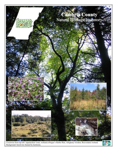
Cambria CountyNatural Heritage InventoryClockwise from top left: Appalachian violet, wetland at Rogue’s Harbor Run, Allegheny woodrat, Beaverdams wetland.Background: beech tree framed by hemlocks.
- Page 3: CAMBRIA COUNTYNATURAL HERITAGE INVE
- Page 7: ACKNOWLEDGEMENTSWe would like to ac
- Page 10 and 11: Landscape Conservation Area (LCA):D
- Page 12 and 13: Figure 1. Natural Heritage Areas in
- Page 14 and 15: Table 1. Natural Heritage Areas Cat
- Page 16 and 17: Table 1. Natural Heritage Areas Cat
- Page 18 and 19: Despite their variable condition to
- Page 20 and 21: additional information on species o
- Page 22 and 23: Carrolltown Borough……………
- Page 25 and 26: INTRODUCTIONOur natural environment
- Page 27 and 28: Natural History Overview of Cambria
- Page 29 and 30: SoilsThe soils of Cambria County ar
- Page 31 and 32: Table 2. Soil Associations of Cambr
- Page 33 and 34: At higher elevations, beech, black
- Page 35 and 36: Because wetlands are relatively rar
- Page 37 and 38: The Eastern Brook Trout Joint Ventu
- Page 39 and 40: Figure 6. PA Department of Environm
- Page 41: Figure 7. Department of Environment
- Page 44 and 45: Fike (1999); for systems not addres
- Page 47 and 48: Figure 9. Interior Forest Habitat B
- Page 49 and 50: General Recommendations for LCA Con
- Page 51 and 52: Below the southern boundary of Alle
<strong>Cambria</strong> <strong>County</strong><strong>Natural</strong> <strong>Heritage</strong> InventoryClockwise from top left: Appalachian violet, wetland at Rogue’s Harbor Run, Allegheny woodrat, Beaverdams wetland.Background: beech tree framed by hemlocks.
CAMBRIA COUNTYNATURAL HERITAGE INVENTORYFebruary 2007Prepared for:<strong>Cambria</strong> <strong>County</strong> Conservation District401 Candlelight Drive, Sute 221Ebensburg, <strong>Pennsylvania</strong> 15931On behalf ofThe <strong>Cambria</strong> <strong>County</strong> CommissionersPrepared by:<strong>Pennsylvania</strong> <strong>Natural</strong> <strong>Heritage</strong> <strong>Program</strong>Western <strong>Pennsylvania</strong> Conservancy209 Fourth AvenuePittsburgh, <strong>Pennsylvania</strong> 15222The <strong>Pennsylvania</strong> <strong>Natural</strong> <strong>Heritage</strong> <strong>Program</strong> (PNHP) is a partnership between the Western <strong>Pennsylvania</strong>Conservancy (WPC), the <strong>Pennsylvania</strong> Department of Conservation and <strong>Natural</strong> Resources (DCNR), the<strong>Pennsylvania</strong> Game Commission (PGC), and the <strong>Pennsylvania</strong> Fish and Boat Commission (PFBC). PNHP isa member of NatureServe, which coordinates natural heritage efforts through an international network ofmember programs—known as natural heritage programs or conservation data centers— operating in all 50U.S. states, Canada, Latin America and the Caribbean.This project was funded through grants supplied by the DCNR Wild Resource Conservation<strong>Program</strong>, the Department of Community and Economic Development, the <strong>Cambria</strong> <strong>County</strong> Alliancefor Business and Industry, and the Conemaugh Valley Conservancy.Copies of this report are available in electronic format through the <strong>Pennsylvania</strong> <strong>Natural</strong> <strong>Heritage</strong> <strong>Program</strong>website (www.naturalheritage.state.pa.us), and through the <strong>Cambria</strong> <strong>County</strong> Conservation District.
PREFACEThe <strong>Pennsylvania</strong> <strong>Natural</strong> <strong>Heritage</strong> <strong>Program</strong> (PNHP) is responsible for collecting, tracking andinterpreting information regarding the Commonwealth’s biological diversity. <strong>County</strong> <strong>Natural</strong> <strong>Heritage</strong>Inventories (CNHIs) are an important part of the work of PNHP. Since 1989, PNHP has conductedcounty inventories as a means to both gather new information about natural resources and to pass thisinformation along to those responsible for making decisions about the resources in the county, includingthe community at large. This <strong>County</strong> <strong>Natural</strong> <strong>Heritage</strong> Inventory focuses on the best examples of livingecological resources in <strong>Cambria</strong> <strong>County</strong>. The county must address historic, cultural, educational, watersupply, agricultural and scenic resources through other projects and programs. Although the inventorywas conducted using a tested and proven methodology, it is best viewed as a preliminary report on thecounty’s natural heritage. Keep in mind that there will be more places to add to those identified here andthat this document can be updated as necessary to accommodate new information. We encourageadditional inventory work across the county to further the efforts begun with this study.Consider the inventory as an invitation for the people of <strong>Cambria</strong> <strong>County</strong> to explore and discuss theirnatural heritage— and to learn about and participate in the conservation of the living resources of thecounty. Ultimately, it will be up to the landowners and residents of <strong>Cambria</strong> <strong>County</strong> to determine how touse this information. Below are some examples of how the inventory can be used by various groups andpeople:Planners and Government Staff. Typically, the planning office in a county administers countyinventory projects. Often, the inventories are used in conjunction with other resource information(agricultural areas, slope and soil overlays, floodplain maps, etc.) in review for various projects and incomprehensive planning. <strong>Natural</strong> <strong>Heritage</strong> Areas may be included under various categories of zoning,such as conservation or forest zones; within parks and greenways; and even within agricultural securityareas. There are many possibilities to provide for the conservation of <strong>Natural</strong> <strong>Heritage</strong> Areas within thecontext of public amenities, recreational opportunities and resource management.<strong>County</strong>, State and Federal Agencies. In many counties, <strong>Natural</strong> <strong>Heritage</strong> Areas lie within or includestate or federal lands. Agencies such as the <strong>Pennsylvania</strong> Game Commission, the <strong>Pennsylvania</strong> Bureau ofForestry, and the U.S. Army Corp of Engineers can use the inventory to understand the geographic extentof the ecological resources highlighted in <strong>Natural</strong> <strong>Heritage</strong> Areas. Agencies can also learn therequirements of the individual plant, animal, or community elements, and the general approachrecommended for their protection. <strong>County</strong> Conservation Districts may use the inventories to focusattention on resources (e.g. high diversity streams or wetlands) and as a reference in encouraging goodmanagement practices.Environmental and Development Consultants. Environmental consultants are called upon to plan for amultitude of development projects including road construction, housing developments, commercialenterprises and infrastructure expansion. Design of these projects requires that all potentially impactedresources be known and understood. Decisions made with inadequate information can lead to substantialand costly delays. <strong>County</strong> <strong>Natural</strong> <strong>Heritage</strong> Inventories provide a first look at biological resources,including plants and animals listed as rare, threatened or endangered in <strong>Pennsylvania</strong> and in the nation.Consultants can therefore see potential conflicts long before establishing footprints or developing detailedplans and before applying for permits. This allows projects to change early on when flexibility is at amaximum.i
ACKNOWLEDGEMENTSWe would like to acknowledge the many citizens and landowners of the county and surrounding areaswho volunteered information, time, and effort to the inventory and granted permission to access land.We especially thank:Dr. Carol Loeffler, pilot for the aerial reconnaissance of the countyRobb Piper, Manager, <strong>Cambria</strong> <strong>County</strong> Conservation DistrictThis project was funded by the Department of Conservation and <strong>Natural</strong> Resources Wild ResourceConservation <strong>Program</strong>, the Department of Community and Economic Development, the <strong>Cambria</strong> <strong>County</strong>Alliance for Business and Industry, and the Conemaugh Valley Conservancy.Without the support and help from these people and organizations, the inventory would not have seencompletion.We encourage comments and questions. The success of the report will be measured by the use it receivesand the utility it serves to those making decisions about resources and land use throughout the county.Thank you for your interest.Jessica McPhersonEcologist<strong>Pennsylvania</strong> <strong>Natural</strong> <strong>Heritage</strong> <strong>Program</strong>Western <strong>Pennsylvania</strong> Conservancyiii
EXECUTIVE SUMMARYIntroductionA healthy natural landscape is vital to thequality of life in human communities. It isalso vital to the survival of the nativebiodiversity that is our natural heritage,connecting us to the past and the future ofour communities and our cultural identity.For all of us, the natural landscape and theecosystem processes it supports providemany services, such as clean water and cleanair, and renew the resources from which wedraw food, raw materials, and economicvitality. Industries that include forestproducts, fishing, outdoor recreation, andnature tourism depend upon a naturallandscape that is well-stewarded for longtermsustainability.The first steps in working towardsstewardship of ecological health in ourlandscape are to characterize the ecosystemsit hosts, understand how they function, andassess how they may be sensitive to humanimpacts. This report contributes to thisendeavor by mapping the location anddescribing the character of many of thecounty’s most significant ecological areas.Additionally, it provides informationregarding their sensitivity to various landuse activities.The report focuses on identifying anddocumenting areas that support exemplarynatural communities, broad expanses ofintact natural ecosystems, and species ofspecial concern. Its aim is to provideinformation to help county, state, andmunicipal governments, private individuals,and business interests plan developmentwith the preservation of an ecologicallyhealthy landscape for future generations inmind.Maps are a key feature of the inventory,outlining the areas identified as supportingimportant ecological elements. The maps donot pinpoint the exact location of species ofconcern or natural communities, but ratherrepresent critical habitat and the surroundinglandscape area necessary to support criticalhabitats and the elements (plants, animals,natural communities) of concern. Asummary table and a written description ofthe sites accompany each map. Potentialthreats and recommendations for protectionof the sites are included for each of theindividual site descriptions.<strong>Natural</strong> <strong>Heritage</strong> InventoryClassificationTo provide the information necessary to planfor conservation of biodiversity at thespecies, community, and ecosystem levels,two types of <strong>Natural</strong> <strong>Heritage</strong> Areas, as wellas designations from the Important MammalAreas Project and Important Bird Areas<strong>Program</strong>, are included in the report.<strong>Natural</strong> <strong>Heritage</strong> AreasBiological Diversity Area (BDA):Definition: An area containing plants oranimals of special concern at state orfederal levels, exemplary naturalcommunities, or exceptional nativediversity. BDAs include both theimmediate habitat and surrounding landimportant in the support of these specialelements.Conservation Planning Application:BDAs are mapped according to theirsensitivity to human activities. “Core”areas delineate essential habitat thatcannot absorb significant levels of activitywithout substantial impact to the elementsof concern. “Supporting <strong>Natural</strong>Landscape” includes areas that maintainvital ecological processes or secondaryhabitat that may be able to accommodatesome types of low-impact activities.v
Landscape Conservation Area (LCA):Definition: A large contiguous area that isimportant because of its size, open space,habitats, and/or inclusion of one or moreBDAs. Although an LCA includes avariety of land uses, it typically has notbeen heavily disturbed and thus retainsmuch of its natural character.Conservation Planning Application:These large regions in relatively naturalcondition can be viewed as regionalassets; they improve quality of life byproviding a landscape imbued with a senseof beauty and wilderness, they provide asustainable economic base, and their highecological integrity offers unique capacityto support biodiversity and human health.Planning and stewardship efforts canpreserve these functions of the landscapeby limiting the overall amount of landconverted to other uses, therebyminimizing fragmentation of these areas.Important Bird Areas (IBA):The <strong>Pennsylvania</strong> Audubon Societyadministers the <strong>Pennsylvania</strong> IBA<strong>Program</strong> and defines an IBA as “a site thatis part of a global network of placesrecognized for their outstanding value tobird conservation.” An IBA can be largeor small, public or private and must meetone of several criteria(http://pa.audubon.org/iba).Conservation Planning Application:Planning for these areas should considerhow best to maintain their value as birdhabitat. The value of some large-scaleIBAs may be due to the forest interiorhabitat contained within them; thus, therecommendations for LCA stewardship tominimize fragmentation are applicable.<strong>Natural</strong> communities that have a particularhabitat value for birds (e.g., wetland) aretypically the basis for smaller-scale IBAs;therefore, a high degree of protectionshould be given to these sites.Conservation plans are in the process ofbeing completed for all IBAs in the state.Important Mammal Areas (IMA):The Important Mammal Areas Project(IMAP) is being carried out by a broadbased alliance of sportsmen, conservationorganizations, wildlife professionals, andscientists. Areas nominated must fulfill atleast one of five criteria developed by theMammal Technical Committee of the<strong>Pennsylvania</strong> Biological Survey(http://www.pawildlife.org/imap.htm).Conservation Planning Application:Planning for these areas should considerhow best to maintain their value asmammal habitat. The value of these sitesmay be associated with high mammaliandiversity, high-density populations,occurrence of species of special concern,or educational potential. Stewardshipplans are in the process of beingcompleted for all IMAs in the state.MethodsFifty-one out of 67 county inventories havebeen completed in <strong>Pennsylvania</strong> to date.The <strong>Cambria</strong> <strong>County</strong> <strong>Natural</strong> <strong>Heritage</strong>Inventory followed the same methodologiesas previous inventories, which proceeded inthe following stages:• site selection• ground survey• data analysisSite SelectionA review of the <strong>Pennsylvania</strong> <strong>Natural</strong>Diversity Inventory (PNDI) database (seeAppendix II) determined where sites forspecial concern species and importantnatural communities were known to exist in<strong>Cambria</strong> <strong>County</strong>. Knowledgeableindividuals were consulted concerning theoccurrence of rare plants and unique naturalcommunities in the county. Geologicalvi
maps, USGS topographical maps, NationalWetlands Inventory maps, USDA soilsurveys, recent aerial photos, and publishedmaterials were also used to identify areas ofpotential ecological significance (Reschke1990). Once preliminary site selection wascompleted, reconnaissance flights overchosen areas of the county were conducted.Wetlands were of primary interest duringfly-overs in <strong>Cambria</strong> <strong>County</strong>.Ground SurveyAreas identified as potential sites werescheduled for ground surveys. Afterobtaining permission from landowners, siteswere examined to evaluate the condition andquality of the habitat and to classify thecommunities present. Field survey forms(Appendix III, pg. 147) were completed foreach site. The flora, fauna, level ofdisturbance, approximate age of communityand local threats were among the mostimportant data recorded for each site. Siteswere not ground surveyed in cases wherepermission to visit a site was not granted,when enough information was availablefrom other sources, or when time did notpermit.Data AnalysisData obtained during the 2003 and 2004field seasons were combined with priorexisting data and summarized. All sites withspecies or communities of statewideconcern, as well as exceptional examples ofmore common natural communities, wereselected as Biological Diversity Areas(BDAs). Spatial data on the elements ofconcern were then compiled in a geographicinformation system (GIS) format usingESRI ArcView 9.1 software.The boundaries defining each BDA werebased on physical and ecological factors,and specifications for species protectionprovided by jurisdictional governmentagencies. The BDAs were then assigned asignificance rank based on size, condition,rarity of the unique feature, and the qualityof the surrounding landscape (see AppendixI, pg. 145 for further description of ranks).Landscape Conservation Areas weredesignated around landscape features thatprovide a uniting element within a collectionof BDAs, or large blocks of contiguousforest identified using GIS-based spatialanalysis. <strong>County</strong> municipalities served asthe organizing unit for the data.ResultsForty-three areas of ecological significanceare recognized in the <strong>Cambria</strong> <strong>County</strong><strong>Natural</strong> <strong>Heritage</strong> Inventory (Figure 1). Thistotal includes 31 Biological Diversity Areasand 12 Landscape Conservation Areas thatare categorized according to theirsignificance to the protection of thebiological diversity and ecological integrityof the region (Table 1). Significance ranksare Exceptional, High, Notable, and <strong>County</strong>.For a complete explanation of these ranks,see Appendix I, pg. 145.*******see map and Table 1, next page*******vii
Figure 1. <strong>Natural</strong> <strong>Heritage</strong> Areas in <strong>Cambria</strong> <strong>County</strong>.viii
Figure 2. Watersheds of <strong>Cambria</strong> <strong>County</strong>.ix
Table 1. <strong>Natural</strong> <strong>Heritage</strong> Areas Categorized by SignificanceSite Municipality Description PageExceptionalAllegheny Front #3 LCAAntis Twp.Gulich Twp.Snyder Twp.Reade Twp.Large contiguous forest block 30Allegheny Front #4 LCAAllegheny Front #8 LCAReade Twp.Antis Twp.Dean Twp.Summerhill Twp.Adams Twp.Large contiguous forest block 30Exceptionally large block of contiguous forest 30Bell's Gap Run BDA Reade Twp. A portion of the Bell's Gap Run Valley that supports aunique community on a calcareous outcrop formation, aplant species of special concern, a population of theAllegheny Woodrat, and an exceptionally mature, intactforest community.Clearfield Creek Pools BDA Dean Twp. A series of natural vernal pools, inhabited by the federallythreatened northeastern bulrush.10777Laurel Ridge LCA #4 Johnstown Area Exceptionally large block of contiguous forest 32Rogue's Harbor Run BDA Chest Twp. Watershed of Rogue's Harbor Run and its tributaries,designated as Exceptional Value waters by the PA-DEP.Also contains a headwaters wetland complex and vernalpools.63State Game Land #42 LCA Johnstown Area Exceptionally large block of contiguous forest 32HighAllegheny Front #7 LCA Summerhill Twp. Large contiguous forest block 30Allwine Run BDA Johnstown Area Watershed of Allwine Creek, designated as ExceptionalValue by the PA-DEPBeaver Valley Wetlands BDA White Twp. A stream valley with a unique and diverse hardwood riparianforest community.Ben's Creek BDA Johnstown Area Watershed of Bens Creek, designated as Exceptional Valueby the PA-DEP9712597Chest Creek at Eckenrode MillsBDAEast Carroll Twp.Allegheny Twp.A natural area along Chest Creek with a mature stand ofhemlock and a wetland complex with a diverse flora.45Chest Creek Headwaters BDA <strong>Cambria</strong> Twp. Watershed above wetland area. 57Gallitzin LCAChest Twp.Clearfield Twp.Moderate-sized block of contiguous forest 32x
Table 1. <strong>Natural</strong> <strong>Heritage</strong> Areas Categorized by SignificanceSite Municipality Description PageLaurel Ridge LCA #1Jackson Twp.Johnstown AreaModerate-sized block of contiguous forest 32Laurel Ridge LCA #2 Johnstown Area Moderate-sized block of contiguous forest 32Laurel Ridge LCA #3 Johnstown Area Moderate-sized block of contiguous forest 32Mill Creek/Little Mill Creek BDA Johnstown Area Watershed of Mill Creek and Little Mill Creek, designated asExceptional Value streams by the PA-DEP97Rogue's Harbor Run LCAChest Twp.Beccaria Twp.White TwpChest Twp.Moderate-sized block of contiguous forest 33South Fork Conemaugh River BDA Adams Twp.Summerhill Twp.Watershed of the South Fork Conemaugh River headwaters,designated as Exceptional Value by the PA-DEP; alsocontains a large natural wetland complex.41South Fork Conemaugh RiverHeadwaters Wetland BDAAdams Twp. A large natural wetland complex. 41Tubb Run Headwaters WetlandBDADean Twp.A headwaters wetland complex that is a mixture of shrub andherbaceous vegetation, with some beaver influence.Inhabited by rare insects.78NotableAllegheny Front #5 LCAAllegheny Front #6 LCAJuniata Twp.Washington Twp.Portage Twp.Portage Twp.Summerhill Twp.Moderate size forest block 30Moderate size forest block 30Clearfield Creek at Amsbry BDA Gallitzin Twp. A lowland forest along Clearfield Creek inhabited by theAppalachian violet88Clearfield Creek Headwaters BDACresson Twp.Allegheny Twp.Forested headwaters of Clearfield Creek, inhabited by theAppalachian violet, a plant species of special concern in PA.47Crooked Run/Elk Creek WetlandsBDABarr Twp.,Blacklick Twp.A complex of wetlands, including forested seeps and amosaic of shrub and graminoid communities.51Laurel Gap Wetland BDACresson Twp.Juniata Twp.A wetland with an open, sphagnum-sedge community and ahemlock-hardwood palustrine forest.71Laurel Run BDA Jackson Twp. The habitat of a plant species of special concern, and thesteep forested slopes above it.91Queen-of-the-Prairie BDAAllegheny Twp.Gallitzin Twp.An area inhabited by queen-of-the-prairie, a plant species ofspecial concern in PA47xi
Table 1. <strong>Natural</strong> <strong>Heritage</strong> Areas Categorized by SignificanceSite Municipality Description PageNotableSouth Branch Blacklick Creek SlopeForest BDAJackson Twp. A very mature stand of hemlock and beech forest 92Staple Bend BDA Johnstown Area A winter bat hibernation site and the disturbance-sensitivearea surrounding it.99<strong>County</strong>Big Cedar Run BDA Summerhill Twp. A hemlock palustrine forest at the mouth of Big Cedar Run. 111Burgoon Run Tributary WetlandBDAWhite Twp. A palustrine forested area fed by seepages. 127Clearfield Creek Floodplain BDAClearfield Creek Floodplain atFallentimber BDAWhite Twp.Reade Twp.Dean Twp.Clearfield Twp.White Twp.Reade Twp.Floodplain forest communities along Clearfield Creek 128Floodplain forest communities along Clearfield Creek 130Killbuck Run BDAChest Twp.White Twp.Forest and wetland communities along Killbuck Run andLittle Killbuck Run.61New Germany Hemlock Grove BDA Croyle Township A stand of exceptionally mature hemlock forest. 75Sam's Run Slope BDA Johnstown Area A forested slope within a matrix of urban land, with a maturesugar maple-basswood forest.Slate Lick Run Wetlands BDA White Twp. A wetland complex, largely forested, with a diverse andunique bottomland hardwood forest community.99132Vintondale Bog Jackson Twp. A wetland with an acidic shrub swamp community. 93Walker Run BDA Blacklick Twp. A ravine with a mature, relatively intact hemlock-northernhardwoods forest community51West Branch Susquehanna BDASusquehanna Twp. A section of the West Branch Susquehanna River withcomparatively natural, forested floodplain115xii
Discussion and RecommendationsStatus of natural features today<strong>Cambria</strong> <strong>County</strong> is situated between theridgelines of Allegheny Front to the east andLaurel Ridge to the west. The western slope ofthe Allegheny Ridge is gentle and does notdescend to the level of the eastern slope, as thelands to the west are uplifted. Laurel Ridge isone of the Allegheny Mountains, and itsnorthern end reaches into <strong>Cambria</strong> <strong>County</strong>.Between these two major ridges, most of thelandscape of the county is gently rolling hillsdissected by stream valleys, with neutral toacidic soils derived from sandstone, shale, andsiltstone. The Eastern Continental Divide alsofalls across the county, with its northeasterntributaries flowing into the Susquehanna Riverand eventually to the Chesapeake Bay and theAtlantic Ocean, and its southwestern tributariesflowing into the Ohio River to feed theMississippi and the Gulf of Mexico.Across this natural geography, the condition ofthe landscape and waterways of <strong>Cambria</strong> <strong>County</strong>has undergone considerable change over thecourse of human settlement. Industry, mining,agriculture, timber extraction, residentialsettlement, and transportation infrastructuredevelopment have all dramatically impacted theecological character and capacity of the land.The condition of the natural landscape todayclosely reflects the history of these activities.The county was settled by Europeans around thebeginning of the 19 th century, which resulted inincreased agricultural cultivation, as well as theadvent of large-scale timber and mineralextraction. During the timber boom in the late19 th and early 20 th centuries, almost all of theforests in the county were clear-cut. Agriculturewas also established in a patchwork pattern,except on the high-elevation ridges. Coalmining began in the late 19 th century, andalthough it reached its height in the early- tomid- twentieth century, it continues today. Stripmining has been extensive in the county anddeep-mining even more extensive, leaving anenvironmental legacy of landscapes scarred bysoil and bedrock disruption, mine refuse dumps,and many waterways polluted by abandonedmine discharges.Johnstown was a major industrial center andcontinues to be a major urban center in<strong>Pennsylvania</strong>. The landscape of the Johnstownarea, and the waterways that flow through it, areheavily impacted by its industrial past.Finally, transportation and utility infrastructureconstruction has had a major impact on thelandscape of <strong>Cambria</strong> <strong>County</strong>. The county has arather extraordinary abundance of right-of-waycorridors criss-crossing its forests today, as wellas several major roadways (U.S. Rt. 22, StateRoutes 219 & 119), and a network of smallerroads. These corridors, especially modernhighway routes, impact the ecological value offorest habitat; the largest right-of-ways androads are major fragmenting features impedingthe passage of wildlife.Forest CommunitiesSince the end of the timber boom at thebeginning of last century, natural communitieshave re-developed in areas not devoted to otheruses. Along the Allegheny Front and the LaurelRidge, large areas of contiguous forest provideabundant habitat for forest dwelling species.Outside of these areas, much of the landscape isforested, but the pattern is a mosaic of forest andother uses, such that forests occur in small,discontiguous patches. Small forest fragmentsdo not provide habitat usable by many nativespecies. However, the forests of the county dohelp to maintain water quality it its streams. Inthe more extensive forested areas, there areseveral streams designated as Exceptional Valueby the <strong>Pennsylvania</strong> Department ofEnvironmental Protection (DEP), due to theirecological health. Outside of these extensivelyforested areas, much of the forest that remains isalong stream channels, providing the beginningsof a network of riparian buffers that can greatlyenhance water quality and aquatic habitat value.Additionally, over-browsing by deer poses athreat to biological diversity and forestregeneration in many regions of the county.xiii
Despite their variable condition today, theforests are a great asset to the ecologicalintegrity of the county, and have the potential tooffer even greater benefits with ecologicallysensitive management into the future.Contiguous forested areas offer enhanced habitatvalue over fragmented forested areas. While anumber of generalist species can succeed andreproduce in small patches of forest, manyspecies can only utilize large, unbroken tracts offorest. Today several such large, contiguousareas exist in the county, with potential tosupport species which are declining in otherareas of the state and the continent due to lack ofhabitat. Furthermore, Laurel Ridge and theAllegheny Front are landforms that naturallyform regional corridors of forest. However,today their value as corridors is diminished byfragmentation by right-of-ways and roads. Withmanagement to improve forest contiguity, evengreater ecological benefits can be realized.There is also potential to benefit biodiversity bymanaging some areas to become old-growthforests. Some species can only find appropriatehabitat in old-growth forests, because thestructures they need for shelter or the foodsources they require are not present in youngerforests. While there are few areas in <strong>Cambria</strong><strong>County</strong> today that are considered old growth, thelarge expanses of younger forests provide thepotential for future development of this habitattype.WetlandsWithin the matrix of forest along the ridgelinesin the county, and along the streams and riversin the valleys, unique wetland communitiesincluding forested seepages, headwaters shrubswamps, vernal pools, and floodplain wetlandsoccur in flat areas where soils and topographyallow accumulation of water. Although thesecommunities occupy a comparatively smallportion of the natural landscape, they are ofparticular value to the county’s biodiversitybecause of the species they support. Groups ofspecialist species—such as amphibians thatbreed only in vernal ponds, or plant species thatlive only in particular types of wetlands—thatwould otherwise not be present in the countyinhabit these areas. These habitats are especiallyimportant because they are regionallythreatened: one-half of <strong>Pennsylvania</strong>’s wetlandshave been lost or substantially degraded, andwetland and aquatic species that depend on thesehabitats are correspondingly declining.Aquatic communities<strong>Cambria</strong> <strong>County</strong> has great variation in aquatichabitat types. The physical settings range fromsmall, steep, headwaters channels, to mid-sizedstreams, to broad rivers. Water chemistry tendstowards acidic, because most surface geology inmost areas is sandstone and shale, which aresometimes naturally acidic and offer nobuffering capacity against acidic inputs fromacid rain or mining discharges. The ecologicalpotential of these habitats is not fully known,because almost all of the larger waterways—North & South Branch Blacklick Creek, theConemaugh River, and Clearfield Creek areheavily polluted by mine drainage. The mostheavily polluted waterways support little life,but many of the smaller streams support some ofthe more tolerant fish and insect species.Pollution from agricultural runoff, minedrainage, and urban runoff remains an issue inmany areas that impedes full biological recoveryand can pose threats to human health. Thelarger rivers, a habitat which is imperiledthroughout our region, have fared the worst,because they accumulate pollution from allupstream sources and because they are oftensubject to extensive physical modification.Planning for biodiversity and ecologicalhealth tomorrowProvision for the future health of ecologicalresources in <strong>Cambria</strong> <strong>County</strong> will require acombination of efforts to steward specific sitesthat host unique species and communities,broader-scale planning to maintain and improvethe contiguity of its forested regions, andrestoration efforts to alleviate water pollutionand restore ecological function to damagedlandscapes and waterways.Forests—maintain & increase contiguityIn the forested landscapes of the Laurel Ridge,the north-central portion of the county, and theAllegheny Front, objectives for large-scalexiv
planning should include maintaining andincreasing contiguity and connectivity of naturalland. Contiguity is important for the enhancedhabitat values outlined above; however, formany species it is equally critical that naturalcorridors are maintained that span betweenforest patches and that connect forests, wetlands,and waterways. Many species—examplesabound among birds, amphibians, anddragonflies— use an aquatic or wetland habitatin one phase of their life, then migrate to anupland, forested habitat for their adult life.Either habitat alone cannot be utilized unless acorridor exists between them.Municipal and regional land use plans cansupport maintenance of forest contiguity byencouraging residential or commercial projectsto re-develop in existing town centers or re-usepreviously altered landscapes, by orienting newinfrastructure along existing corridors ratherthan through unfragmented natural landscapes,and by encouraging riparian buffer development.A Riparian greenway network— many benefitsThe county’s network of streams provides anatural opportunity to develop ecologicalconnectivity in the county’ s landscape. Forestalready exists along many waterways, andestablishment of riparian buffers where they donot currently exist conveys a multitude ofbenefits for water quality, soil preservation, andhabitat value. Restoration of native vegetationto riparian corridors and buffers will help greatlyin improving water quality and enhancing thehabitat value of the waterways for variousaquatic and semi-aquatic species. Furthermore,a riparian greenway network can also aid inreducing flooding damages, and improve thescenic beauty and recreational value of thewaterways. Reduction in the release ofpollutants into runoff, including sediments,nutrients, and chemical contaminants, will alsobe necessary to improve water quality.Attending to the basic ecological functions ofstreams and wetlands will pay dividends byensuring the continued capacity of the land insupporting agriculture, maintaining healthyfisheries, and providing the quality of the life forwhich the region is known.Wetlands—worth saving<strong>Natural</strong> wetlands that are in good condition arehighlighted in this report; due to their scarcityand their high ecological importance, emphasisshould be placed on conservation of wetlandsites.Evaluating proposed activity within<strong>Natural</strong> <strong>Heritage</strong> AreasA very important part of encouragingconservation of the <strong>Natural</strong> <strong>Heritage</strong> Areasidentified within the <strong>Cambria</strong> <strong>County</strong> <strong>Natural</strong><strong>Heritage</strong> Inventory is the careful review ofproposed land use changes or developmentactivities that overlap with <strong>Natural</strong> <strong>Heritage</strong>Areas. The following overview should provideguidance in the review of these projects oractivities.Always contact the <strong>Cambria</strong> <strong>County</strong> PlanningOffice. The <strong>County</strong> Planning Office should beaware of all activities that may occur within<strong>Natural</strong> <strong>Heritage</strong> Areas in the county so that theymay interface with the <strong>County</strong> ConservationDistrict and other necessary agencies ororganizations to better understand theimplications of proposed activities. They canalso supply guidance to the landowners,developers, or project managers as to possibleconflicts and courses of action.The <strong>Cambria</strong> <strong>County</strong> <strong>Natural</strong> <strong>Heritage</strong> Inventoryis not meant to be used as a substitute forenvironmental review, since information isconstantly being updated as natural resources areboth destroyed and discovered. Applicants forbuilding permits and Planning Commissionsshould conduct free, online, environmentalreviews to inform them of project-specificpotential conflicts with sensitive naturalresources. Environmental reviews can beconducted by visiting the <strong>Pennsylvania</strong> <strong>Natural</strong><strong>Heritage</strong> <strong>Program</strong>’s (PNHP) website, athttp://www.naturalheritage.state.pa.us/.If conflicts are noted during the environmentalreview process, the applicant is informed ofthe steps to take to minimize negative effects onthe county’s sensitive natural resources. Ifxv
additional information on species of specialconcern becomes available duringenvironmental review, the review may bereconsidered by the jurisdictional agency. Ingeneral, the responsibility for reviewing naturalresources is partitioned among agencies in thefollowing manner:• U.S. Fish and Wildlife Service for allfederally listed plants or animals.• <strong>Pennsylvania</strong> Game Commission for allstate and federally listed terrestrialvertebrate animals.• <strong>Pennsylvania</strong> Fish and BoatCommission for all state and federallylisted reptiles, amphibians, and aquaticvertebrate and invertebrate animals.• <strong>Pennsylvania</strong> Bureau of Forestry for allstate and federally listed plants.• <strong>Pennsylvania</strong> <strong>Natural</strong> <strong>Heritage</strong><strong>Program</strong> (PNHP) for all naturalcommunities, terrestrial invertebratesand species not falling under the abovejurisdiction.PNHP and agency biologists can provide moredetailed information with regard to thelocation of natural resources of concern in aproject area, the needs of the particular resourcesin question, and the potential impacts of theproject to those resources.If a ground survey is necessary to determinewhether significant natural resources are presentin the area of the project, an agency biologistwill recommend a survey be conducted. Earlyconsideration of natural resource impacts isrecommended to allow sufficient time forthorough evaluation. Given that some speciesare only observable or identifiable during certainphases of their life cycle (i.e., the floweringseason of a plant or the flight period of abutterfly), a survey may need to be scheduled fora particular time of year.If the decision is made to move forward with aproject in a <strong>Natural</strong> <strong>Heritage</strong> Area, PNHP staffcan work with municipal officials and projectpersonnel during the design process to developstrategies for minimizing the project’s ecologicalimpact while meeting the project’s objectives.The resource agencies in the state may dolikewise.Early consultation and planning as detailedabove can provide for a more efficient and betterintegrated permit review, and a betterunderstanding among the parties involved as tothe scope of any needed project modifications.xvi
TABLE OF CONTENTSPREFACE……………………………………………………………………………………..………… iACKNOWLEDGEMENTS………………………………………………………………………..…… iiiEXECUTIVE SUMMARY………………………………………………………………………...…… vIntroduction…………………………………………………………………………………………. v<strong>Natural</strong> <strong>Heritage</strong> Inventory Classification………………………………………………….….…… vMethods……………………………………………………………………………….……………. viResults…………………………………………………………………………………….……….. viiDiscussion and Recommendations……………………………………………………..………….. xiiiINTRODUCTION………………………………………………………………………………………. 5<strong>Natural</strong> History Overview of <strong>Cambria</strong> <strong>County</strong>……………………………………..………………. 7METHODS…………………………………………………………………………………...…………. 23RESULTS……………………………………………………………………………………………… 25Landscape Conservation Areas……………………………………………………………….….… 25Background…………………………………………………………...………………………... 25General Recommendations for LCA Conservation………………………………….…………. 29<strong>Cambria</strong> <strong>County</strong> LCAs…………………………………………………………………..…….. 30Forest Certification <strong>Program</strong> Information......................................................................................... 36Biological Diversity Areas (Listed By Municipality)………………………………….…………… 39Summary Table Conventions………………………………………………………...………… 39TownshipsAdams Township…………………………………………………………..……………… 40Allegheny Township………………………………………………………….……………. 44Barr Township…………………………………………………………………….………. 48Blacklick Township………………………………………………………….……………. 50<strong>Cambria</strong> Township………………………………………………………………………... 56Chest Township………………………………………………………………….………… 60Clearfield township……………………………………………………………….………. 68Cresson Township……………………………………………………………….………… 70Croyle Township………………………………………………………………….……….. 74Dean Township…………………………………………………………………….………. 76East Carroll Township……………………………………………………………….…….. 82East Taylor Township………………………………………………………….………….. 96Elder Township……………………………………………………………………………. 84Gallitzin Township………………………………………………………………………… 86Jackson Township…………………………………………………………………………. 90Johnstown Area…………………………………………………………………….……… 96Lower Yoder Township…………………………………………………………………… 96Middle Taylor Township…………………………………………………….……………. 96Munster Township………………………………………………………………………… 102Portage Township……………………………………………………………….………… 104Reade Township……………………………………………………………………….…. 106Richland Township……………………………………………………………..………. … 96Stonycreek Township…………………………………………………………..…………. 96Summerhill Township………………………………………………………….………. … 110Susquehanna Township……………………………………………………………….…. 114Upper Yoder Township…………………………………………………………………… 96Washington Township……………………………………………………...……………. 120West Carroll Township…………………………………………………………...……… 122West Taylor Township………………………………………………………….…………. 96White Township…………………………………………………………………………… 124BoroughsAshville Borough…………………………………………………………………..……… 761
Carrolltown Borough…………………………………………………………………..…... 82Cassandra Borough……………………………………………………..…………………. 120Chest Springs Borough……………………………………………………………………. 44Conemaugh Township…………………………………………………………………….. 96Cresson Borough…………………………………………………………………………… 70Dale Borough……………………………………………………………….….. …………. 96Ehrenfeld Borough……………………………………………………………………..…... 74Ferndale Borough………………………………………………………………………..…...96Gallitzin Borough………………………………………………………………………….. 86Geistown Borough…………………………………………………………………………. 96Hastings Borough…………………………………………………………………...……... 84Lilly Borough……………………………………………………………………………… 120Loretto Borough…………………………………………………………………….…….. 44Northern <strong>Cambria</strong> Borough……………………………………………………………….. 114Nanty Glo Borough………………………………………………………………………… 50Patton Borough…………………………………………………………………………….. 68Portage Borough…………………………………………………………………………… 104Sankertown Borough………………………………………………………………………. 70Scalp Level Borough………………………………………………………………………. 96South Fork Borough……………………………………………………………………….. 74Southmont Borough……………………………………………………………………….. 96Summerhill Borough………………………………………………………………………. 74Tunnelhill Borough………………………………………………………………………… 86Vintondale Borough……………………………………………………………………….. 90Westmont Borough………………………………………………………………………… 96Wilmore Borough………………………………………………………………………….. 110GENERAL RECOMMENDATIONS………………………………………………………………….. 135GLOSSARY……………………………………………………………………………………………. 139LITERATURE CITED…………………………………………………………………………………. 141Appendix I: Significance Ranks……………………………………………………………………….. 145Appendix II: <strong>Pennsylvania</strong> <strong>Natural</strong> <strong>Heritage</strong> <strong>Program</strong> (PNHP)………………………………………… 146Appendix III: <strong>Cambria</strong> <strong>County</strong> <strong>Natural</strong> <strong>Heritage</strong> Inventory Site Survey Form………………………… 147Appendix IV: Classification of <strong>Natural</strong> Communities in <strong>Pennsylvania</strong>……………………………….. 149Appendix V: Federal and State Endangered Species Categories, Global and State Element Ranks….. 155Appendix VI: Plants and animals of special concern in <strong>Cambria</strong> <strong>County</strong>…………………………….. 161Appendix VII: Sustainable Forestry Information Sources…………………………………………….. 162Appendix VIII: GIS data sources……………………………………………………………………… 164Appendix IX: Species Fact Sheets…………………………………………………………………….. 1662
LIST OF TABLESTable 1. <strong>Natural</strong> <strong>Heritage</strong> Areas Categorized by Significance ....................................................................xTable 2. Soil Associations of <strong>Cambria</strong> <strong>County</strong>..........................................................................................11Table 3. Prime Farmland Soils in <strong>Cambria</strong> <strong>County</strong> ...................................................................................12Table 4. Hydric Soils in <strong>Cambria</strong> <strong>County</strong>..................................................................................................12LIST OF FIGURESFigure 1. <strong>Natural</strong> <strong>Heritage</strong> Areas in <strong>Cambria</strong> <strong>County</strong>...............................................................................viiiFigure 2. Watersheds of <strong>Cambria</strong> <strong>County</strong>...................................................................................................ixFigure 3. Physiographic Provinces in <strong>Cambria</strong> <strong>County</strong>...............................................................................8Figure 4. Soil Association Map of <strong>Cambria</strong> <strong>County</strong>..................................................................................10Figure 5. Status of Eastern Brook Trout in <strong>Cambria</strong> <strong>County</strong>.....................................................................18Figure 6. PA Department of Environmental Protection impaired stream designations in.........................19<strong>Cambria</strong> <strong>County</strong>. ........................................................................................................................19Figure 7. Department of Environmental Protection 305(b) Stream Classification, <strong>Cambria</strong> <strong>County</strong>.........21Figure 8. Forest Cover and Forest Fragmentation in <strong>Pennsylvania</strong>. ..........................................................26Figure 9. Interior Forest Habitat Blocks in <strong>Cambria</strong> <strong>County</strong>.....................................................................27Figure 10. Areas in <strong>Cambria</strong> <strong>County</strong> meeting FSC standards for High Conservation Value Forests. ......373
INTRODUCTIONOur natural environment is vital for human health and sustenance. A healthy environment provides cleanair and water; supports fish, game and agriculture; and furnishes renewable sources of materials forcountless aspects of our livelihoods and economy. In addition to these material services, a clean andhealthy environment plays a central role in our quality of life, whether through its aesthetic value—foundin forested ridges, mountain streams, and encounters with wildlife—or in the opportunities it provides forexploration, recreation, and education. Finally, a healthy natural environment supports economic growthby adding to the region’s attractiveness as a location for new business enterprises, and provides the basisfor the recreation, tourism and forestry industries—all of which have the potential for long-termsustainability. Fully functional ecosystems are the key indicators of a healthy environment and working tomaintain ecosystems is essential to the long-term sustainability of our economies.An ecosystem is “the complex of interconnected living organisms inhabiting a particular area or unit ofspace, together with their environment and all their interrelationships and relationships with theenvironment” (Ostroumov 2002). All the parts of an ecosystem are interconnected—the survival of anyspecies or the continuation of a given natural process depends upon the system as a whole, and in turn,these species and processes contribute to maintaining the system. An important consideration inassessing ecosystem health is the concept of biodiversity. Biodiversity can be defined as the full variety oflife that occurs in a given place, and is measured at several scales: genes, species, natural communities,and landscapes.Genetic diversity refers to the variation in genetic makeup between individuals and populations oforganisms and provides a species with the ability to adapt successfully to environmental changes. In orderto conserve genetic diversity, it is important to maintain natural patterns of gene flow through themigration of individual plants and animals across the landscape and the dispersal of pollen and seedsamong populations (Thorne et al. 1996). Individual species play a role in sustaining ecosystem processessuch as nutrient cycling, decomposition, and plant productivity: declines in native species diversity alterthese processes (Naeem et al. 1999).A natural community is “an interactive assemblage of plant and animal species that share a commonenvironment and occur together repeatedly on the landscape” (Massachusetts Biomap 2001). <strong>Natural</strong>communities are usually defined by their dominant plant species or the geological features on which theydepend; examples include red maple swamp, hemlock forest, and serpentine grassland. Each type ofnatural community represents habitat for a different assemblage of species, hence identification andstewardship of the full range of native community types is needed to meet the challenge of conservinghabitat for all species.From an ecological perspective, a landscape is “a large area of land that includes a mosaic of naturalcommunity types and a variety of habitats for many species.” (Massachusetts Biomap 2001). At thisscale, it is important to consider whether communities and habitats are isolated or connected by corridorsof natural landscape traversable by wildlife, and whether the size of a natural landscape is sufficient tosupport viable populations and ecosystems. Because all the living and non-living elements of anecosystem are interconnected and interdependent, it is essential to conserve native biodiversity at all thesescales (genes, species, natural communities, and landscapes) if ecosystems are to continue functioning.<strong>Pennsylvania</strong>’s natural heritage is rich in biodiversity and the state includes many examples of highquality natural communities and large expanses of natural landscapes. Over 20,000 species are known tooccur in the state, and the extensive tracts of forest in the northern and central parts of the state represent alarge fraction of the remaining areas of suitable habitat in the mid-Atlantic region for many forestdependentspecies of birds and mammals. Unfortunately, biodiversity and ecosystem health are seriouslythreatened in many parts of the state by pollution and habitat loss. Of the 3500 species of animals andvascular plants that have been documented in the state, more than one in ten are imperiled, 156 have been5
lost since European settlement, and 351 are threatened or endangered (<strong>Pennsylvania</strong> 21st CenturyEnvironment Commission 1998). Many of these species are imperiled because available habitat in thestate has been reduced and/or degraded.Fifty-six percent of <strong>Pennsylvania</strong>’s wetlands have been lost or substantially degraded by filling, draining,or conversion to ponds (Dahl 1990). According to the <strong>Pennsylvania</strong> Department of EnvironmentalProtection (DEP), 60% of those <strong>Pennsylvania</strong> lakes that have thus far been assessed for biological healthare listed as impaired. Of 83,000 miles of stream in <strong>Pennsylvania</strong>, almost 70,000 miles have beenassessed for water quality and nearly 11,000 miles have been designated as impaired due to abandonedmine discharges (AMD), acid precipitation, and agricultural and urban runoff (PA-DEP 2006). Thespecies that depend on these habitats are correspondingly under threat: 58% of threatened or endangeredplant species are wetland or aquatic species; 13% of <strong>Pennsylvania</strong>’s 200 native fish species have beenlost, while an additional 23% are imperiled; and among freshwater mussels— one of the most globallyimperiled groups of organisms— 18 of <strong>Pennsylvania</strong>’s 67 native species are extinct and another 22 areimperiled (Goodrich et al. 2003).Prior to European settlement, over 90% of <strong>Pennsylvania</strong>’s land area was forested. Today, 60% of thestate is still forested, but much of this forest is fragmented by non-forest uses such as roads, utility rightof-ways,agriculture, and housing: only 42% is of the forest is interior forest habitat, and some of thespecies that depend upon interior forest habitat are in decline (Goodrich et al. 2003). In addition tohabitat fragmentation, forest pests, acid precipitation (which causes nutrient leaching and stunted growth),overbrowsing by deer, and invasive species also threaten forest ecosystem health.The <strong>Pennsylvania</strong> <strong>Natural</strong> <strong>Heritage</strong> <strong>Program</strong> (PNHP) assesses the conservation needs of animal andvascular plant species native to <strong>Pennsylvania</strong>. While <strong>Pennsylvania</strong> also hosts a diversity of other lifeforms such as mosses, fungi, bacteria, and protists, too little is known of these species to assess theirconservation status. The goal of this report is to identify areas important in sustaining biodiversity atthe species, natural community, and landscape levels and provide that information to more fullyinform land use decisions. Using information from PNHP, <strong>County</strong> <strong>Natural</strong> <strong>Heritage</strong> Inventories(CNHIs) identify areas in the county that support <strong>Pennsylvania</strong>’s rare, threatened or endangered speciesas well as natural communities that are considered to be rare in the state or exceptional examples of themore common community types. The areas that support these features are identified as BiologicalDiversity Areas (BDAs). At a broader scale, CNHIs recognize landscape-level features termed LandscapeConservation Areas (LCAs). LCAs identify areas of relatively intact natural landscape such as large areasof forest unbroken by roads or other fragmenting features; areas which function as a corridor connectingpatches of natural landscape; and regions in which a high number of other biodiversity features areconcentrated.A description of each area’s natural features and recommendations for maintaining their viability areprovided for each BDA and LCA. Also, in an effort to provide as much information as possible focusedon planning for biodiversity conservation, this report includes species and natural community fact sheets,references and links to information on invasive exotic species, and mapping from other conservationplanning efforts such as the <strong>Pennsylvania</strong> Audubon’s Important Bird Area <strong>Program</strong>. Together with otherland use information, this report can help to guide the planning and land management necessary tomaintain the ecosystems on which our living heritage depends.6
<strong>Natural</strong> History Overview of <strong>Cambria</strong> <strong>County</strong>The climate, topography, geology and soils are particularly important in the development of ecosystems(forests, fields, wetlands) and physical features (streams, rivers, mountains) that occur in <strong>Cambria</strong><strong>County</strong>. Disturbance, both natural and anthropogenic (human-caused), has been influential in formingand altering many of <strong>Cambria</strong> <strong>County</strong>’s ecosystems, causing extinction of some species and theintroduction of others. These combined factors provide the framework for locating and identifyingexemplary natural communities and species of special concern in the county. The following sectionsprovide a brief overview of the physiography, soils, surface water, and vegetation of <strong>Cambria</strong> <strong>County</strong>.Physiography and GeologyA physiographic province is a geographic region in which all parts are similar in geologic structure andclimate and which has a unified geomorphic or surficial history. Physiography relates in part to a region’stopography and climate. These two factors, along with bedrock type, significantly influence soildevelopment, hydrology, and land use patterns of an area. Additionally, both physiography and geologyare important to the patterns of plant community distribution, which in turn influences animaldistribution. Because of the differences in climate, soils, and moisture regimes, certain plant communitieswould be expected to occur within some provinces and not others.Although all of <strong>Cambria</strong> <strong>County</strong> falls within the Appalachian Plateau physiographic province, it includesseveral distinct topographic landforms that are classified into physiographic subsections—the LaurelRidge of the Allegheny Mountains, the Allegheny Front, and the Low Plateau (Figure 3). <strong>Cambria</strong><strong>County</strong> falls between the ridgelines of two of the Allegheny Mountains; Allegheny Ridge (at the county’seastern edge) and Laurel Ridge (at its western edge). The Allegheny Mountains are an old mountainchain characterized by broad ridges formed by underlying rock which has been mildly folded, in contrastto the intensely folded ridges of the Ridge and Valley to the east, and the generally horizontal strata of theAllegheny Plateau to the west (Braun 1950). Several long, broad ridges of the Alleghenies extend fromMaryland north into Central <strong>Pennsylvania</strong>: Laurel Ridge, Chestnut Ridge, and Allegheny Ridge. LaurelRidge reaches its northern extent in the middle of <strong>Cambria</strong> <strong>County</strong>, where it declines in elevation and isno longer a distinctly prominent landform, while the Allegheny Ridge declines somewhat in elevationacross the county, but remains a prominent feature for many more miles to the northeast.The Allegheny Ridge marks the division between the Ridge and Valley physiographic province and theAppalachian Plateau province. The western slope of the Allegheny Ridge is gentle and does not descendto the level of the eastern slope, as the lands to the west are uplifted. The rock underlying theAppalachian Plateau is layers of sandstone and shale that originated from sediment deposition andcompression; these layers were uplifted 500-400 million years ago when two island chains collided withthe eastern edge of North America (the Taconic and Acadian orogenies – mountain-building events) toform a plateau elevated above the surrounding regions. Most of the landscape is gently rolling hillsdissected by stream valleys, with neutral to acidic soils derived from sandstone, shale, and siltstone. TheEastern Continental Divide also falls across the county, with its northeastern tributaries (Chest Creek,Clearfield Creek, and the headwaters of the West Branch Susquehanna River) flowing into theSusquehanna River to the Chesapeake Bay and the Atlantic Ocean, and its southwestern tributaries (theNorth and South Fork Blacklick Creek, North Branch Conemaugh River, South Branch ConemaughRiver, and Little Conemaugh River) flowing into the Ohio River to feed the Mississippi and the Gulf ofMexico.7
ClearfieldCentreIndianaPittsburgh Low Plateau<strong>Cambria</strong>BlairWestmorelandAllegheny MountainAllegheny FrontAppalachianMountainBedfordAppalachian Plateaus Physiographic ProvinceSomersetAllegheny Front SectionPittsburgh Low Plateau SectionMiles5 2.5 0 5Kilometers5 2.5 0 5Figure 3. Physiographic Provinces in <strong>Cambria</strong> <strong>County</strong>.8Allegheny Mountain SectionRidge & Valley Physiographic ProvinceAppalachian Mountain Section
SoilsThe soils of <strong>Cambria</strong> <strong>County</strong> are mainly derived from erosion or weathering of the sandstone, shale, andsiltstone materials that predominate in the county’s surface geology. They are acidic to neutral inchemistry, range from well-drained to poorly drained, often have an impervious layer present below thesurface, and tend to be moderately deep to deep. In the extensive areas where surface mining hasoccurred, soils are much thinner, rockier, nutrient-poor, and often extremely well drained. This conditionprofoundly impairs the potential of the land to support regeneration of ecological communities similar tothose naturally found in the region.A soil association is a natural grouping of soils based on similarities in climatic or physiographic factorsand soil parent materials. It may include a number of soil types, provided they are all present insignificant proportions. The soils of <strong>Cambria</strong> <strong>County</strong> have been described in Soil Survey of <strong>Cambria</strong><strong>County</strong>, <strong>Pennsylvania</strong> (Farley 1985). The four soil associations recognized within the county aredescribed in Table 2 and represented in Figure 4. Due to the similarity in bedrock and landformconditions in the county, many of these soils are broadly similar in their composition and characteristics.VegetationForest CommunitiesThe mountain ridges hold the largest contiguous blocks of forest in the county. The Allegheny Front andthe Laurel Ridge include large tracts of interior forest, while the intervening areas are a patchwork ofdifferent landuses, with small fragments of forest mainly along stream valleys. The northcentral region ofthe county also has some extensive forested areas.Almost all of the forests in the county are second-growth or third-growth stands, except for a fewremaining fragments where the maturity of the trees suggests they may not have ever been cut. <strong>Cambria</strong><strong>County</strong> is in a transition area between major forest types, with oak – chestnut communities historicallyprevailing in the Ridge and Valley to the east, hemlock (white pine) – northern hardwood communitiesprevailing to the north, and mixed mesophytic communities prevailing to the west and south (Braun1950). The mixed mesophytic type is characterized by a great diversity of species in the canopy andherbaceous layers, many of which are endemic to the southern Appalachian mountains. <strong>Cambria</strong> <strong>County</strong>is at the extreme northern edge of the range of this forest type, and no examples of mixed mesophyticprimary growth remain. It once occupied lower elevation areas, especially slopes of stream valleys cutinto the plateau-like valleys between the Allegheny ridges (Braun 1950).In general, forest composition depends greatly on elevation, slope, and aspect. At lower elevations, thecanopy is mixed, with typical species including tuliptree (Liriodendron tulipifera), sugar maple (Acersaccharum), red maple (Acer rubrum), basswood (Tilia americana), cucumber magnolia (Magnoliaacuminata), black cherry (Prunus serotina), white oak (Quercus alba), red oak (Quercus rubra), blackbirch (Betula lenta), hickories (shagbark, pignut, bitternut—Carya ovata, Carya glabra, and Caryacordiformis), and beech (Fagus grandifolia). Spicebush (Lindera benzoin), shadbush (Amelanchierarborea), and witch hazel (Hamamelis virginiana) are typical shrub or subcanopy species. Theherbaceous layer is also typically diverse, with a mixture of northern and southern species. These forestsmay be considered mixed mesophytic-influenced in the diversity and heterogeneity of their composition.On steep or convex slopes, chestnut oak (Quercus montana), red oak, and black gum (Nyssa sylvatica)increase in proportion and may dominate the canopy, and heaths such as mountain laurel (Kalmialatifolia), lowbush blueberry (Vaccinium angustifolium, Vaccinium pallidum), and teaberry (Gaultheriaprocumbens) may dominate the understory.9
Figure 4. Soil Association Map of <strong>Cambria</strong> <strong>County</strong>.Reprinted from Soil Survey of <strong>Cambria</strong> <strong>County</strong>.10
Table 2. Soil Associations of <strong>Cambria</strong> <strong>County</strong>.SoilAssociation Parent Materials DescriptionCookport-Hazleton-LaidigResiduum and colluviumweathered from acid sandstone,siltstone conglomerate, shale,and siltstone.Deep; nearly level to steep;moderately well drained to welldrained, occur on broad mountainsand broad to narrow ridges that havecolluvial side slopes dissected bydrainageways.Percentageof <strong>County</strong>45Land UsePrimarily forest, with some areas used for crops or pasture,and a few areas in urban or industrial use. Main limitationsare stoniness, slope, erosion, and a seasonal high water table.Gilpin-Ernest-WhartonResiduum and colluviumformed from acid shale andsandstone, and siltstone.Moderately deep and deep, gentlysloping to moderately steep, welldrained and moderately well drainedsoils on ridges and hills that aredissected by drainageways.39Most areas of this association are in cropland and woodland.Some areas are used for urban and industrial development.Limitations on uses are moderate depth to bedrock, aseasonal high water table, slow permeability, and slope.Brinkerton-Wharton-CavodeResiduum and colluviumformed from shale, sandstone,and acid gray clay shale.Deep, nearly level to moderatelysteep, poorly drained to moderatelywell drained soils on broad ridgesdissected by drainageways.12Most areas of this association are in crops, hay, and pasture.Main limitations on use are a seasonal high water table, slowpermeability, and erosion.Atkins-PhiloAlluvium washed fromsandstone-, shale-, andsiltstone-derived soils.Deep, nearly level, poorly drainedand moderately well drained soils infloodplains.4Most areas of this association are in pasture, woodland, andurban uses. Main limitations on uses are a seasonal highwater table and flooding.11
Table 3. Prime Farmland Soils in <strong>Cambria</strong> <strong>County</strong>Map SymbolAbBCeACeBGnBHaBHaCLaBLkBPhPoRaBWaB *Map NameAlbrights silt loam, 3 to 8 percent slopesCookport and Ernest soils, 0 to 3 percent slopesCookport and Ernest soils, 3 to 8 percent slopesGilpin silt loam, 3 to 8 percent slopesHazleton channery loam, 3 to 8 percent slopesHazleton channery loam, 8 to 15 percent slopesLaidig loam, 3 to 8 percent slopesLeck Kill silt loam, 3 to 8 percent slopesPhilo silt loamPope silt lamRayne silt loam, 3 to 8 percent slopesWharton silt loam, 3 to 8 percent slopes* Some nonprime farmland areas are included in this mapping unit; however, it is our best judgment thatin this county, over 50 percent of this unit have slopes of less than 5.4 percent and this soil qualifies forprime farmland.Table 4. Hydric Soils in <strong>Cambria</strong> <strong>County</strong>Map SymbolAmBAtBtBBvBNcBMap NameArmagh silt loam, 0 to 8 percent slopesAtkins silt loamBrinkerton silt loam, 0 to 8 percent slopesBrinkerton very stony silt loam, 0 to 8 percent slopesNolo very stony sandy loam, 0 to 8 percent slopeStatewide Important SoilsAbCAtBeBBeCBmBBmCBpCCaBCaCCeCGtCGwBGwCLaCLkCRaCWaCWgCAlbrights silt loam,Atkins silt loamBerks channery silt loam, 3 to 8 percent slopesBerks channery silt loam, 8 to 15 percent slopesBlairton silt loam, 3 to 8 percent slopesBlairton silt loam, 8 to 15 percent slopesBlairton-Berks channery silt loams, 8 to 15 percent slopesCavode silt loam, 3 to 8 percent slopesCavode silt loam, 8 to 15 percent slopesCookport-Ernest soils, 8 to 15 percent slopesGilpin-Rayne silt loams, 8 to 15 percent slopesGilpin-Weikert channery silt loam, 3 to 8 percent slopesGilpin-Weikert channery silt loam, 8 to 15 percent slopesLaidig Loam, 8 to 15 percent slopesLeck Kill silt loam, 8 to 15 percent slopesRayne silt loam, 8 to 15 percent slopesWharton silt loam, 8 to 15 percent slopesWharton-Gilpin silt loams, 8 to 15 percent slopes12
At higher elevations, beech, black birch, and sugar maple become the canopy dominants, and species suchas cucumber magnolia and tuliptree are absent. Diversity tends to be lower in both the canopy andherbaceous layer, where northern species become more prominent.Wetland CommunitiesWetlands include vegetation types important for the region, and provide essential habitat for many plantand animal species. The type of wetland existing in any given place depends on soil type, disturbance,and length and duration of flooding. In <strong>Cambria</strong> <strong>County</strong>, many of the wetlands are associated withstreams or rivers and include floodplain forests, forested swamps, shrub swamps, and graminoid marshes.They may occur in floodplains or in headwaters of waterways. Two other important wetland types knownfrom the area are seepage swamps and vernal pools. As with forest communities, the influence ofbedrock geology on soil and water chemistry strongly influences the plant composition of wetlandcommunities. Sandstone and shale bedrock predominates in <strong>Cambria</strong> <strong>County</strong>, thus most of its wetlandsare fed by groundwater or surface water with neutral to acidic chemistry. The degree of acidity willinfluence the plant and animal composition of a wetland. Highly acidic wetlands tend to be dominated bysphagnum mosses and have low plant species diversity, although some of the species found are adapted tothese conditions and not found in other habitats. They may support a variety of insect species adapted foracidic conditions. Amphibians typically breed in wetlands, but may be unsuccessful in highly acidicsituations. More neutral water chemistry results in a greater diversity of plant and amphibian species.Floodplain and Riparian WetlandsFloodplain forests occur along rivers and streams in low-lying areas. These locations are periodicallyinundated by the floodwaters of spring runoff or runoff from intense storm events. In central<strong>Pennsylvania</strong>, where floodplains exist in relatively natural conditions, forests are characterized by acanopy containing some combination of silver maple (Acer saccharinum), sycamore (Platanusoccidentalis), tuliptree (Liriodendron tulipifera), black willow (Salix nigra), green ash (Fraxinuspensylvanica), American elm (Ulmus americana), or box-elder (Acer negundo). Shrubs and vinescommon to these forests include spicebush (Lindera benzoin), ninebark (Physocarpus opulifolius),silky dogwood (Cornus amomum), Virginia creeper (Parthenocissus quinquefolia), and poison ivy(Toxicodendron radicans). Floodplain forest communities receive severe disturbances fromfloodwaters including erosion, scouring by ice and debris, and/or deposition of considerablequantities of sediment and debris. Only species with adaptations or tolerance for these kinds ofconditions can survive here.Floodplains on smaller waterways receive less intense disturbances but are still periodically flooded,which limits the kinds of vegetation that can occur on them. Pin oak (Quercus palustris), swampwhite oak (Quercus bicolor), silver maple, red maple, ash, sycamore, and black walnut (Juglansnigra) are frequent on wetter bottomland soils associated with smaller creeks. Understory speciesinclude spicebush, violets (Viola spp.), nettles (Urtica dioica, Laportea canadensis), cut-leavedconeflower (Rudbeckia laciniata), golden alexanders (Zizia aurea) and many other wildflowers.Several species of special concern are frequently found in these habitats. In addition, floodplainforests also serve as a protective buffer against erosion; help provide cooling shade to the waterway;filter pollutants and excessive nutrients from runoff; and help alleviate flood damage along many ofthe area’s creeks. Areas that have a history of flooding are poor choices for building sites, and arebest left as natural floodplain.In <strong>Cambria</strong> <strong>County</strong>, the best examples of natural floodplain habitats are found along Clearfield Creek,its tributary the Beaverdam Branch, and in a few areas along the headwaters of the West BranchSusquehanna River. The Conemaugh River and its tributaries, except in the headwaters, are heavilydeveloped, and in undeveloped areas Japanese knotweed and other invasive species have becomeubiquitously established.13
Graminoid MarshesGraminoid marshes are wetlands dominated by grass-like plants such as cattails (Typha latifolia),sedges (Carex spp.), and grasses. These wetlands may be found in association with streams or inareas with ground water seepages. Graminoid marshes in the county are frequently formed assuccessional communities following beaver dams or other impoundments. These wetlands arefrequently rich in species diversity, and provide important breeding habitat for numerous amphibians,reptiles and birds. Good examples are found in the Rogue’s Harbor Run BDA, pg. 63; the South ForkConemaugh River BDA, pg. 41; the Killbuck Run Wetland core area in the Killbuck Run BDA, pg.61; and the Slate Lick Run Wetlands BDA, pg. 132.Seepage SwampsSeepage swamps are relatively small, forested or shrub-dominated wetlands found on lower slopeswhere water emerges at the surface in a diffuse flow. These seep areas are frequently dominated byhemlock, yellow birch and red maple, with a thick understory of rhododendron (Rhododendronmaximum), swamp azalea (Rhododendron viscosum), spicebush, and/or highbush blueberry(Vaccinium corymbosum). Common herbs in these seepage wetlands include skunk cabbage(Symplocarpus foetidus), violets, manna grass (Glyceria spp.), various sedges (Carex spp.), and ferns,including cinnamon fern (Osmunda cinnamomea), royal fern (O. regalis), and sensitive fern (Onocleasensibilis). Sphagnum (Sphagnum spp.) and other mosses typically form a thick mat in thesewetlands. Two good examples of this habitat in <strong>Cambria</strong> <strong>County</strong> are the Killbuck Run PalustrineForest (Killbuck Run BDA, pg. 61) and the Chest Creek Headwaters BDA, pg. 57.Vernal PoolsEphemeral/fluctuating or vernal pools are wetlands that fill annually from precipitation, surface waterrunoff, and rising groundwater (Kenney and Burne, 2000). The pools typically become completelydry through evaporation by late spring or summer. Since these ponds dry up during a portion of theyear, they cannot support fish populations. During the brief time the pools contain water, and in theabsence of fish, they become important breeding areas for a multitude of amphibian species (e.g.,spotted salamander, Ambystoma maculatum), many of which breed solely in vernal pools. In<strong>Cambria</strong> <strong>County</strong>, vernal pool communities are found in broad, flat saddles along the Allegheny Front,and also in a similar topographic situation in the headwaters of Rogue’s Harbor Run in the northcentralportion of the county. Pools form in the center of broad, flat areas because there is noopportunity for drainage. They are often the origin point for stream tributaries.High-elevation Headwaters Swamps or “Bogs”Often in flat areas near the origins of waterways, wetlands develop from accumulation of surfacerunoff and groundwater inputs. The character and extent of these wetlands often varies as beaveractivity fluctuates over time. They may range from highly acidic herbaceous wetlands dominated bysphagnum moss, beaked rush (Rhynchospora alba), cottongrass (Eriophorum virginicum), and sedges(Carex folliculata, Carex gynandra, Carex atlantica); to shrublands with rough alder (Alnus incana),black huckleberry (Gaylussacia baccata), inkberry (Nemopanthus mucronatus), blueberries(Vaccinium angustifolium, Vaccinium pallidum), winterberry (Ilex verticillata); to varying degrees offorest cover with hemlock (Tsuga canadensis), red maple (Acer rubrum), black gum, and swampshadbush (Amelanchier laevis). Often these wetlands will be a mosaic of woodland, shrubland, andherbaceous forms, depending upon subtle variations in elevation and seasonal saturation. They areoften referred to as “bogs." True bogs, however, have a floating layer of peat at the surface at least 9”thick.14
Because wetlands are relatively rare in central <strong>Pennsylvania</strong>, they are an important refuge for plants aswell as important habitat for nesting and migrating birds. Many other animals groups such asamphibians, reptiles, dragonflies, damselflies, moths, and butterflies also depend on specific wetlandhabitats for all or a portion of their life cycles.Wetlands of <strong>Cambria</strong> <strong>County</strong>Seepage/back channel wetland along Laurel RunSphagnum moss-graminoid headwaters wetland(in South Fork Conemaugh River Headwaters Wetland)Floodplain forest along Beaverdam Run15
Aquatic Ecosystems – Streams & Lakes<strong>Cambria</strong> <strong>County</strong> is situated across the Eastern Continental Divide, with rolling topography cut bystreams. Its northern portion contains headwaters streams feeding the West Branch Susquehanna River,which flows ultimately to the Chesapeake Bay, while the southern portion of the county is the headwatersof the Conemaugh River, which flows ultimately to the Mississippi River and the Gulf of Mexico. Thecounty’s far western edge also includes some portions of the headwaters of the Juniata River. There areno natural lakes in the county, although many streams have been dammed to create reservoirs.The prevailing geology of acid sandstones, shales, and siltstones leads to streams that are naturally neutralto acidic in pH level. Because of the general absence of limestone or other calcareous geology, thestreams tend to have little buffering capacity, and acidic pollution sources quickly alter the overall pH of astream.In the last two centuries, land cover changes have dramatically affected the health of aquatic ecosystemsin the county. Widespread timbering in the late 19 th and 20 th centuries created erosion problems; deepmining in much of the county has left a legacy of mining discharges polluting many waterways, and stripmining also contributes to acidic runoff and erosion, resulting in pollution of streams with sediments,metals, and pH-altering chemicals. During the development of steel manufacturing and other heavyindustries, waterways were used as conduits to carry wastes off-site—into the surrounding environments.Many efforts at remediation have reduced pollution problems from the severity of decades past, such thata good fraction of the waterways in the county have made gains in their ecological health. However,water quality in the county is still impaired in many areas by pollution from mine discharges, and by siltrunoff from agricultural or residential areas. The naturally rolling topography of the land facilitateserosion, requiring vigilant implementation of soil conservation practices to prevent pollution fromreaching the streams. Because of the degradation of many headwaters streams, most larger waterwayscarry substantial pollution loads—including the Conemaugh River, the West Branch Susquehanna River,Blacklick Creek, and Clearfield Creek. Chest Creek and the headwaters of the South Fork ConemaughRiver are comparatively healthy.In the most severely affected areas, the water is not safe for human consumption and supports no aquaticlife. Less severely affected streams often support a range of species that are tolerant of pollution, but lackthe full complement of species that would be present in a healthy system. Water pollution is absorbed byall aquatic organisms, and is concentrated by organisms higher in the food chain—thus posing risks forhumans consuming fish or shellfish from any polluted waters. Most communities in <strong>Cambria</strong> <strong>County</strong>depend upon streams and reservoirs for drinking water, and in these areas water pollution directly impactshuman health for all. Healthy streams and aquatic ecosystems are also important to the overall ecologicalhealth of the region because all animals depend on water, and because the aquatic and terrestrial systemsare linked by many relationships of interdependence among species. Although many challenges remainin restoring the county’s waterways to health, there are also headwaters watersheds that are nowpredominantly forested and in good health from which to build upon.Figure 6 shows which streams have been designated as impaired by the <strong>Pennsylvania</strong> Department ofEnvironmental Protection (DEP), while Figure 5 shows the DEP designations for aquatic ecosystem typeand for watersheds of especial ecological value. Portions of five Exceptional Value streams fall within<strong>Cambria</strong> <strong>County</strong>: Allwine Creek and Mill Run in the southwest corner; Rogues Harbor Run along thenorthern border with Clearfield <strong>County</strong>; and the headwaters of Ben’s Creek and the South ForkConemaugh River in the southeastern corner of the county. Additionally, much of the headwaters ofChest Creek is designated High Quality, as well as Laurel Run (SW, flowing into the Conemaugh River),Saltlick Run, the headwaters of the North Fork Conemaugh River, Beaverdam Run, and Sandy Run(tributary to Clearfield Creek).16
The Eastern Brook Trout Joint Venture (EBTJV) – a collaboration between government agencies,academic institutions, and conservation groups – recently published an assessment of the status of thenative brook trout (throughout its historic range (Hudy et al. 2005). While aquatic ecosystems comprisean assemblage of many species of insects, fish, amphibians, and plants, in watersheds where the brooktrout has historically been present, the health of its populations can serve as one indicator of overallecological health. The report found that the dramatic land use changes of the last several centuries havegreatly impacted the brook trout, reducing its historic range and diminishing its populations. The specieshas been eliminated from approximately one quarter of the habitat where it once occurred, and reduced tosmall headwaters habitats in another quarter. More information is available at:http://www.easternbrooktrout.org.Figure 5 shows the EBTJV report’s assessment of subwatersheds in <strong>Cambria</strong> <strong>County</strong>. The brook trouthas been extirpated from several subwatersheds, and greatly reduced (reproducing in only 10-49% of itshistoric habitat area) in a large portion of the county. Populations are only somewhat reduced in portionsof the Stonycreek River watershed (Bens Creek), portions of the Conemaugh River watershed (LaurelRun, Hinckston Run, and St. Clair Run), and the headwaters of the North Fork Conemaugh River. Inthese watersheds there are reproducing populations in 50-90% of the historic habitat area. Additionally,the report found that brook trout are present in the headwaters of the South Fork Conemaugh River, butdid not have enough data to assess how much of the historic range they now occupy.17
Figure 5. Status of Eastern Brook Trout in <strong>Cambria</strong> <strong>County</strong>.Status assessed relative to the habitat historically occupied by the species. Data published by the EasternBrook Trout Joint Venture: see page 16 for more detail.18
Figure 6. PA Department of Environmental Protection impaired stream designations in<strong>Cambria</strong> <strong>County</strong>.19
PA Department of Environmental Protection 305(b) DesignationsThe following definitions of 305(b) designations are taken from the <strong>Pennsylvania</strong> Code, Chapter 93.(http://www.pacode.com/secure/data/025/chapter93/chap93toc.html)Trout Stocking Fishery: Maintenance of stocked trout from February 15 to July 31, & maintenance& propagation of fish species & additional flora & fauna that are indigenous to a warm water habitat.Warm Water Fishery: Maintenance and/or propagation of fish species and additional flora andfauna which are indigenous to a warm water habitat.Cold Water Fishery: Maintenance and/or propagation of fish species, including the familySalmonidae and additional flora and fauna, which are indigenous to a cold-water habitat.High Quality Waters: A surface water that meets one or more criteria for excellent water quality, orhas been designated as a Class A wild trout stream by the Fish and Boat Commission followingpublic notice and comment. The criteria for water chemistry and biology (the support of a highquality aquatic community) are listed in PA Code § 93.4b.Exceptional Value Waters: A surface water that meets one or more of the following conditions is anExceptional Value Water:(1) The water meets the requirements of subsection (a) and one or more of the following:i) The water is located in a National wildlife refuge or a State game propagation and protectionarea.ii) The water is located in a designated State park natural area or State forest natural areas,National natural landmark, Federal or State wild river, Federal wilderness area or Nationalrecreational area.iii) The water is an outstanding National, State, regional or local resource water.iv) The water is a surface water of exceptional recreational significance.v) The water achieves a score of at least 92% (or its equivalent) using the methods andprocedures described in subsection (a)(2)(i)(A) or (B).vi) The water is designated as a ‘‘wilderness trout stream’’ by the Fish and Boat Commissionfollowing public notice and comment.(2) The water is a surface water of exceptional ecological significance.Additional Notes on the designations:• High Quality and Exceptional Value designations are protected, meaning that the water qualitycannot be degraded beneath the conditions currently supported. As stream health is integrallydependent on the condition of land in the watershed, this protection extends to the watershed.• Not all PA water bodies have been reviewed to determine whether they qualify as High Quality orExceptional Value; review of a particular water body can be initiated by petition to the DEP.• Standards for High Quality and Exceptional Value waters have changed in recent years to includemore detailed chemical and biological criteria. Therefore, waterways designated prior to thischange may not have been evaluated according to current criteria.• Trout Stocking implies that water quality is sufficient for trout survival, but the stream may ormay not support natural reproduction.20
Figure 7. Department of Environmental Protection 305(b) Stream Classification, <strong>Cambria</strong> <strong>County</strong>.21
METHODSFifty-one county inventories have been completed in <strong>Pennsylvania</strong> to date. The methods used in the<strong>Cambria</strong> <strong>County</strong> <strong>Natural</strong> <strong>Heritage</strong> Inventory followed established <strong>Pennsylvania</strong> <strong>Natural</strong> <strong>Heritage</strong> <strong>Program</strong>procedures, which are based on those used by Anonymous (1985), Reese et al. (1988), and Davis et al.(1990). <strong>Natural</strong> <strong>Heritage</strong> Inventories proceed in three stages: (1) site selection based on existing data,map and aerial photo interpretation, recommendations from local experts, and aerial reconnaissance; (2)ground surveys; and (3) data analysis and mapping.Site SelectionInventory site selection is guided by information from a variety of sources. A review of the <strong>Pennsylvania</strong><strong>Natural</strong> <strong>Heritage</strong> <strong>Program</strong> database (see Appendix II) determined what locations were previously knownfor species of special concern and important natural communities in <strong>Cambria</strong> <strong>County</strong>. Local citizensknowledgeable about the flora and fauna of <strong>Cambria</strong> <strong>County</strong> were contacted for site suggestions.Individuals from academic institutions and state and federal agencies that steward natural resources (e.g.,<strong>Pennsylvania</strong> Game Commission, <strong>Pennsylvania</strong> Bureau of Forestry,) were also contacted to obtaininformation about lands or resources they manage. National Wetland Inventory maps, compiled by theUS Fish and Wildlife Service, were used to locate wetlands of potential ecological significance within thecounty. General information from other sources such as soil maps, geology maps, earlier field studies,and published materials on the natural history of the area helped to provide a better understanding of thearea’s natural environment.Aerial photographs were reviewed to identify sites for ground survey. Initial study of aerial photosrevealed large-scale natural features (e.g., contiguous forest, wetlands), disturbances (e.g., utility lineright-of-ways, strip mines, timbered areas) and a variety of easily interpretable features. Oncepreliminary site selection was completed, reconnaissance flights over chosen areas of the county wereundertaken. Information concerning extent, quality, and context within the landscape can be gatheredeasily from the air. Wetlands, contiguous blocks of forest, and limestone or sandstone cliffs were ofprimary interest during fly-overs in <strong>Cambria</strong> <strong>County</strong>. Based on aerial photo interpretation and aerialsurveys, some sites were eliminated from consideration if they proved to be highly disturbed, fragmented,lacked the targeted natural feature, or were purely attributable to human-made features (e.g.,impoundments, clearings, farm fields).Ground SurveysAreas identified as inventory sites were scheduled for ground surveys. Biologists conducted field surveysthroughout <strong>Cambria</strong> <strong>County</strong> during 2003 and 2004. After obtaining permission from landowners, siteswere examined to evaluate the condition and quality of the habitat and to classify the communitiespresent. Field survey forms (see Appendix III) were completed for each site. Boundaries for each sitewere drawn on USGS 1:24,000 topographic maps. If a species of special concern was recorded and thepopulation was of sufficient size and vigor, a voucher specimen was collected and archived in theherbarium of the Carnegie Museum of <strong>Natural</strong> History. The flora, fauna, level of disturbance,approximate age and condition of forest community, and local threats were among the most importantdata recorded for each site. Sites were not ground surveyed in cases where landowner permission for sitevisits was not obtained, or sufficient information was available from other sources.Data Analysis and MappingData on species of special concern and natural communities obtained during the 2003 and 2004 fieldseasons were combined with prior existing data and summarized. Plant and animal species nomenclaturefollows that adopted by the <strong>Pennsylvania</strong> Biological Survey. Community descriptions primarily follow23
Fike (1999); for systems not addressed in Fike (i.e., subterranean and non-vegetated habitats), Smith(1991) was followed.Biological Diversity AreasAll sites with rare species and/or natural communities, as well as exceptional examples of more commonnatural communities, were selected for inclusion in Biological Diversity Areas (BDAs). Spatial data onthe elements of concern were then compiled in a Geographic Information System (GIS) format usingESRI ArcView 9.0 software. Boundaries defining Core Habitat and Supporting <strong>Natural</strong> landscape foreach BDA were derived from the occupied habitat data based upon <strong>Pennsylvania</strong> <strong>Natural</strong> <strong>Heritage</strong><strong>Program</strong> conservation planning specifications for the elements of concern within the BDA. Specificationsoutline protocols for identifying land important in the support of elements of concern and are based onscientific literature and professional judgment for individual species or taxonomic groups of species.They may incorporate physical factors (e.g., slope, aspect, hydrology), ecological factors (e.g., speciescomposition, disturbance regime), and specifications provided by jurisdictional government agencies.Boundaries tend to vary in size and extent depending on the physical characteristics of a given site and theecological requirements of its unique natural elements. For instance, two wetlands of exactly the samesize occurring in the same region may require areas of very different size and extent for support if onereceives mostly ground water and the other mostly surface water, or if one supports migratory waterfowland the other does not. BDAs were assigned a significance rank to help prioritize future conservationefforts. This ranking is based on the extent, condition, and rarity of the unique feature, as well as thequality of the surrounding landscape (see Appendix I for further description of ranks).Landscape Conservation AreasLandscape Conservations Areas (LCAs) are delineated to include large areas of intact natural landscape,and to include areas important in large-scale ecological processes. LCAs may be large blocks ofcontiguous forest, extensive wetland complexes, areas linking ecologically significant features such asthose recognized for BDAs, and otherwise comparatively (relative to an individual county) undisturbed,ecologically intact portions of the landscape.In <strong>Cambria</strong> <strong>County</strong>, contiguous forest blocks were identified, and LCAs were selected from among theseblocks based on several criteria: (1) contiguously forested areas of exceptional size, (2) blocks whichwere part of a ridgeline and separated from other large blocks only by minor fragmenting features, and (3)blocks which were adjacent to Biological Diversity Areas hosting species which depend upon foresthabitat.Blocks of contiguous forest were identified by means of GIS analysis, refined through aerial photographinspection, and selected based on size. Forested areas were identified though a classification of 1992National Land Coverage Data (NLCD), compiled from Landsat TM (thematic mapping) satellite imagerywith a resolution of 30 meters, downloaded from the <strong>Pennsylvania</strong> Spatial Data Access (PASDA) website(http://pasda.psu.edu). Land coverage types used in the analysis were transitional, deciduous forest,coniferous forest, mixed forest, woody wetlands, and emergent herbaceous wetlands. Roads, activerailroads, and utility right-of-ways were considered fragmenting features. Existing GIS data for roads,which included interstates, US and state highways, state, county and township roads, and active railroads,were combined with utility right-of-way locations digitized from aerial photos. Analysis to identifycontiguous blocks of forest was conducted using the map calculator function of the Spatial AnalystExtension in ArcView 9.0. The results were then compared against aerial photos and any discernablenon-forested areas were removed. Forest blocks less than 1 acre were then removed. Total acreage aswell as core forest acreage were then calculated for all remaining blocks. A detailed description of theGIS analysis is available upon request from the GIS Specialist, <strong>Pennsylvania</strong> <strong>Natural</strong> <strong>Heritage</strong> <strong>Program</strong>.24
LANDSCAPE CONSERVATION AREAS (LCAs)BackgroundPrior to European settlement, forest covered more than 90 percent of <strong>Pennsylvania</strong> (Goodrich et al. 2003).Today, 62 percent of the state is forested, comprising an area of over 17 million acres (Figure 8;Goodrich et al. 2003, Myers et al. 2000). However, much of this forest exists as relatively small islandsisolated by surrounding linear features such as roads, utility right-of-ways, and railroads, as well as nonforestlands. A number of studies have looked at the effects of roads and other linear features on thelandscape. Ecological impacts of these fragmenting features include (1) direct mortality of wildlife fromvehicles; (2) disruption of wildlife dispersal; (3) habitat fragmentation and loss; (4) imposition of edgeeffects; (5) spread of exotic species; (6) alteration of the chemical environment.Roads can be a significant source of mortality for a variety of animals. Few if any terrestrial species areimmune. Amphibians may be especially vulnerable to road-kill because their life histories often involvemigration between wetland and upland habitats, and individuals are inconspicuous. One study conductedin southeastern <strong>Pennsylvania</strong> documented over 100 road-killed salamanders and frogs on a single-milestretch of road during one rainy night in the spring breeding season (Goodrich et al. 2003). Large andmid-sized mammals are particularly susceptible to vehicle collisions on secondary roads, while birds andsmall mammals are most vulnerable on wider, high-speed highways (Forman & Alexander 1998). InUpper St. Clair Township, <strong>Pennsylvania</strong>, over the last four years, white-tailed deer mortality due to roadkillswas approximately four times higher than mortality due to hunting (Upper St. Clair TownshipDepartment of Deer Management 2005). A total of 637 bobcats (Lynx rufus) were reported as road-killsin <strong>Pennsylvania</strong> from 1985 to 2000 (Goodrich et al. 2003). A 10-year study of road mortality in NewJersey recorded 250 dead raptors representing 12 species along a 90-mile section of road (Loos &Kerlinger 1993, cited in Goodrich et al. 2003).Animals may alter their behavior in the presence of a road. One study found that small forest mammals(e.g., eastern chipmunk, eastern gray squirrel, and deer mouse) were reluctant to venture onto roadsurfaces where the distance between forest margins exceeded 20 m. The same study concluded that afour-lane divided highway might be as effective a barrier to the dispersal of small forest mammals as abody of fresh water twice as wide (Oxley et al. 1974). A study conducted in North Carolina found thatblack bears shift their home ranges away from areas with high road densities (Brody & Pelton 1989).Songbirds seem to be especially sensitive to traffic noise; it interferes with their vocal communication andthus affects their territorial behavior and mating success (Seiler 2001).Roads, wide trails, and grassy corridors can also function as barriers restricting the movement ofinvertebrates and amphibians. Populations of microhabitat-specific species like land snails andsalamanders, which generally require moist habitats, may be isolated by inhospitable xeric corridors(Williams 1995, Blaustein et al. 1994). Some forest butterflies, like the West Virginia white (Pierisvirginiensis), will not cross open habitats and its current rarity may be a function of habitat fragmentationand isolation (Williams 1995). Consequences of the isolation of populations include reduced geneticdiversity and low recruitment rates that can, in turn, result in local extinctions (Seiler 2001).Fragmentation of formerly contiguous forested landscapes into smaller, isolated tracts has an effect onplant and animal distribution and community composition. When an extensive forest tract is fragmented,the resulting forest islands may lack the full range of microhabitats that existed in the original tract. If ahabitat fragment lacks required microhabitat(s), or is smaller than the minimum area required by a givenspecies, individuals of that species will not likely be found within that habitat fragment (Lynch &Whigham 1984). For example, the Louisiana Waterthrush (Seirus motacilla) is rarely found in smallwoodlots because it requires upland forest streams within its territory, and most small woodlots lack thisnecessary component (Robbins 1980, Robinson 1995). Area-sensitive species such as Northern25
Figure 9. Interior Forest Habitat Blocks in <strong>Cambria</strong> <strong>County</strong>.The highlighted blocks represent the forested areas with 600 acres or more of contiguous interior forest habitat.Underlying the blocks is forest cover. Although much of the county is forested, the pattern of fragmentation issuch that little interior forest of a size usable by wildlife dependent on these conditions remains.27
Goshawk (Accipiter gentilis), Barred Owl (Strix varia), bobcat, and timber rattlesnake (Crotalushorridus) require interior forest areas in excess of 6,000 acres to accommodate breeding and foragingterritories (Squires & Reynolds 1997, Mazur & James 2000, Ciszek 2002, NatureServe 2005).Along with a reduction in total forested area, forest fragmentation creates a suite of “edge effects” whichcan extend more than 300 meters into the remaining fragment (Forman & Deblinger 2000). Edge forest iscomposed of a zone of altered microclimate and contrasting community structure distinct from theinterior, or core forest (Matlack 1993). Edge forest is typically characterized by a harsher environmentthan that of interior forest. Edges experience increased light intensity, altered insect and plant abundance,a depressed abundance and species richness in macroinvertebrate soil fauna, and a reduced depth of theleaf-litter layer (Yahner 1995, Haskell 2000, Watkins et al. 2003). The macroinvertebrate fauna found inleaf litter is significant for the pivotal role it plays in energy and nutrient cycling; thesemacroinvertebrates also provide prey for salamanders and ground-feeding birds. A number of studieshave shown that the nesting success of forest-interior songbirds is lower near forest edges than in theinterior because of increased densities of nest predators and brood parasites (reviewed in Murcia 1995).Roads can act as corridors for plant dispersal, and exotic species increase their range by spreading alongroadsides (Watkins et al. 2003). Vehicles and road-fill operations transport exotic plant seeds intouninfested areas, and road construction and maintenance operations provide safe sites for seedgermination and seedling establishment (Schmidt 1989; Greenberg et al. 1997; Trombulak & Frissell2000). Unpaved road edges often have exposed areas of mineral soil and suitable light and moistureconditions that allow exotic seeds to become established (Parendes & Jones 2000, Trombulak & Frissell2000).Road traffic and maintenance of right-of-ways contribute at least six different classes of chemicals to theenvironment: heavy metals, salt, organic pollutants, ozone, nutrients, and herbicides (Forman &Alexander 1998, Trombulak & Frissell 2000). Heavy metals, which include lead, aluminum, iron,cadmium, copper, and manganese, contaminate soils, plants, and invertebrates up to 200 m from roads, aswell as vertebrate fauna foraging within the affected zone (Trombulak & Frissell 2000). One study foundelevated lead concentrations in tissue of several small mammal species in a narrow zone by roads (Getz etal. 1977, cited in Forman & Alexander 1998). Deicing salts contribute ions to the soil, altering pH andsoil chemical composition, which affects plant growth (Forman & Alexander 1998, Trombulak & Frissell2000). Airborne sodium chloride from snowplowing may cause leaf injury to trees (e.g., white pine) upto 120 meters from a road, especially downwind and downslope (Forman & Alexander 1998). Organicpollutants such as dioxins and polychlorinated biphenyls (PCBs) are present in higher concentrationsalong roads and hydrocarbons may accumulate in aquatic ecosystems near roads (Trombulak & Frissell2000). Vehicles produce ozone, which increases the concentration of this gas in the lower atmospherewhere it acts as a greenhouse gas (Trombulak & Frissell 2000). Storm runoff from roads, particularlywhere roads abut or cross water bodies, results in the transport of nutrients and sediments into aquaticecosystems (Trombulak & Frissell 2000). Herbicides are often applied to roadsides and utility right-ofwaysto control woody plant growth. Forest edge and interior plant species can be damaged or destroyedby drifting or misapplied herbicide (Williams 1995, Forman & Frissell 2000).Humans are an integral part of natural history, where we function as ecosystem engineers, altering thelandscape around us to suit our needs. Some species benefit from human-induced changes, such as birdsthat inhabit the early successional and edge habitats provided by utility corridors or disturbance-adaptedplants that colonize roadsides. But as is more often the case, species with specific habitat requirementstend to suffer declining numbers when faced with human encroachment. Given the pervasiveness ofhuman influence throughout the northeastern United States, the ecological importance of large areas ofrelatively pristine habitat cannot be overestimated.28
General Recommendations for LCA ConservationLCAs are large areas with ownership typically divided among many entities, individual, corporate, andpublic. Because their unique value arises from large-scale contiguity of natural ecosystems, the greatestthreat to their future viability is fragmentation of natural cover by interruptions in the forest landscape.Conservation of these areas’ unique habitat value and their ability to continue providing ecosystemservices will require coordinated efforts by the many landowners involved to preserve ecosystem health atthe local scale and forest cover contiguity at the regional scale.Features that fragment habitat for different species range from dirt trails to roads, gas wells, cleared areas,and land conversion for residential, urban, or industrial use. Species have different thresholds for whatdegree of disturbance will be a barrier to movement or make adjacent forest habitat unusable to them.However, as the collection of fragmenting features of all types grows, the amount of area influenced byedge effects grows and the ability of the ecosystem to support its most sensitive species declines. In<strong>Cambria</strong> <strong>County</strong>, the largest areas of contiguous forest occur along the Laurel Ridge and along theAllegheny Front; substantial forest areas are also found in the north-central part of the county. TheAllegheny Front and Laurel Ridge have the potential to form corridors of natural landscape across theregion. However, because they are long and linear, they are easily subject to fragmentation from roadsand right-of-ways crossing them laterally.Fragmentation can be minimized by utilizing existing disturbances for new projects rather than clearingadditional forest, by consolidating roads and right-of-ways where multiple routes exist, and by restoringunused cleared areas such as abandoned roads, wells, or mined areas to forest. When planning the path ofa fragmenting land use change, impact can be minimized by avoiding complete division of the LCA; anyfeature which cuts completely across the contiguous forested area will effectively create two separate,smaller communities, while preservation of a linkage at least several hundred meters wide preservesoverall contiguity of the forest block. The impact of individual features such as wells, roads, right-ofways,or other clearings can also be minimized by the use of ecologically informed best managementpractices in construction and maintenance (see Arkansas Forestry Commission reference on pg. 141 forroad management; Appendix VII on pg. 162 for additional information sources).In addition to forest contiguity, it is also important to steward forest ecosystem health— by managing fornative diversity in plant, animal, and other species, and conserving ecologically important aspects of thephysical landscape such as soil structure, naturally decomposing dead wood, and structural diversity inforest composition. Timber harvesting can be compatible with the ecological viability of the region if it ispursued according to a Forest Management Plan designed for the long-term sustainability of both thetimber resource and the forest ecosystem, with the use of ecologically informed best managementpractices. Surface mining in previously unmined areas is not compatible with the ecological assets of thearea. Mined areas create a permanent loss of habitat, as it is extremely difficult if not impossible torestore a forest ecosystem with healthy function and biodiversity in the environmental conditions thatresult after mining. Mining also causes water quality degradation that is difficult to remediate. A numberof resources, listed in Appendix VII (pg. 162), are available to private landowners interested insustainably managing their forestlands for biodiversity conservation, forest health, and forest productsincluding timber, mushrooms, and high-value medicinal herbs. A good place to start is the PA Bureau ofForestry’s Forest Stewardship <strong>Program</strong>, which assists landowners in developing a forest managementplan based on their envisioned goals for their land.29
<strong>Cambria</strong> <strong>County</strong> LCAsThe landscape of <strong>Cambria</strong> <strong>County</strong> is a mosaic of forest, agriculture, small towns, and lands used forindustrial or extractive purposes. There is an extensive network of roads and pipeline or powerlinecorridors crisscrossing the county as well. Thus, although a large percentage of the county’s land area isforested (63%), much of that forest occurs in small patches interrupted by infrastructure corridors or nonforestland uses. Only 23% of the forested area (14.5% of the county area) occurs in contiguous blocksthat are large enough to be ecologically significant for forest-dependent species. A rough measure for thesize necessary to be considered ecologically significant is the area needed for neotropical bird species toreproduce successfully, 600 acres (Robbins et al. 1989). Figure 9 (pg. 27) shows the blocks ofcontiguous forest in <strong>Cambria</strong> <strong>County</strong> that are 600 acres in size or greater. The unique ecological value oflarge, contiguous forest ecosystems is that they have the capacity to be resilient to natural disturbancesand to host a full range of native forest ecosystem biodiversity, including the most sensitive forest speciesthat require interior forest conditions or large territories. These areas are crucial habitat for species suchas neotropical migrant birds, bobcats, and bats. The portions of the county with the most contiguousforests are in the southwest corner, along Laurel Hill; in the northcentral region of the county, centered onRogue’s Harbor Run; and along the Allegheny Front at the eastern edge of the county. The largestcontiguous forest blocks in these areas, which extend beyond the county borders to connect withextensive forests in neighboring counties, have been selected as Landscape Conservation Areas. Featuressuch as ridgelines, which are typically heavily forested and unsuitable for intensive development oragriculture, also offer the potential to serve as corridors of natural landscape, providing regionalconnectivity between natural areas and providing migration routes for highly mobile and migratoryspecies. In <strong>Cambria</strong> <strong>County</strong>, the features that most strongly offer this potential are the Allegheny Frontand Laurel Ridge. Figure 1 (pg. viii) maps all the <strong>Natural</strong> <strong>Heritage</strong> Areas in <strong>Cambria</strong> <strong>County</strong>, includingthe LCAs. Figure 10 (pg. 37) displays the LCAs with a background of all forest cover in the county,providing a visual display of their relative contiguity.The Allegheny Front LCAsDescriptionThe Allegheny Front has the best potential of any of central <strong>Pennsylvania</strong>’s large-scale features to serveas a regional corridor connecting the forests of West Virginia all the way up to the Allegheny NationalForest. It remains largely forested, and includes large tracts of public land. It spans the border between<strong>Cambria</strong> and Blair Counties, with many contiguous forest areas shared by both. In this area, it isfragmented at regular intervals by roads and right-of-ways, and in some areas by past mining andtimbering operations, but also includes the largest remaining contiguous blocks of forest habitat in bothcounties. These areas are also the watersheds of drinking water supply for Tyrone, Bellwood, andAltoona, and the forested condition of the land maintains good water quality. The forest types tendtowards northern hardwoods communities where they are at least moderately mature. Sugar maple,beech, and black cherry are prominent and often extend even to higher elevation regions typicallyoccupied by oak forest types, due to heavy oak mortality from past gypsy moth infestations. Youngerforests are generally dominated by black birch or red maple saplings.Allegheny Front LCA #3 & #4Both these LCAs meet the estimated size necessary to sustain viable populations of neotropicalmigrant birds (9000 acres) and of the Northern Goshawk (10,500 acres), a bird of prey which has avery large individual home range territory (Anderson & Vickeray in press). Several BiologicalDiversity Areas are embedded within these forest blocks (see pg. 77; Tubb Run Headwaters WetlandBDA, pg. 78; and Bell’s Gap Run BDA, pg. 107).30
Below the southern boundary of Allegheny Front LCA #4, which is a very wide powerline right-ofway,the Allegheny Front in the east-central region of <strong>Cambria</strong> <strong>County</strong> is more fragmented. Forestcover is broken by several small roads and residential extensions of Altoona and Cresson, as well asfairly extensive surface-mined areas. U.S. Route 22 is a major fragmenting feature, and south of Rt.22 the forest is regularly transected by several right-of-ways.Allegheny Front LCA #5, 6, 7, 8The southeastern part of <strong>Cambria</strong> <strong>County</strong> falls across a relatively intact section of the AlleghenyFront. These LCAs are designated for several contiguous blocks of forest that are clustered togetherin this area.Allegheny Front LCA #5 is a moderately large block of contiguous forest that is separated byrelatively minor fragmenting features— two small roads— from smaller blocks to the north and east.Allegheny Front LCA #6 is also of moderate size, separated from the larger Allegheny Front LCA #7by a large powerline right-of-way. It contains one Biological Diversity Area; the Big Cedar RunBDA (pg. 111). Allegheny Front LCA #8 is an exceptionally large block, which meets the estimatedsize necessary to sustain viable populations of neotropical migrant birds (9000 acres) and of theNorthern Goshawk (10,500 acres), a bird of prey which has a very large individual home rangeterritory. Over half of the LCA is also the headwaters of the South Fork Conemaugh River, which aredesignated as Exceptional Value (EV) stream reaches by the PA Department of EnvironmentalProtection. The EV portions of the stream and their watershed are recognized as the South ForkConemaugh River BDA (pg. 41). Another unique feature of the LCA is an extensive natural wetland,recognized as the South Fork Conemaugh River Headwaters Wetland BDA (pg. 43).Threats and StressesThe soil along the Allegheny Front is naturally somewhat acidic and nutrient poor, and the terrain is oftenvery steeply sloped. Due to these factors, long-term forest ecosystem health in the region is especiallyvulnerable to soil erosion from removal of forest canopy or soil disturbance. It is also especiallyvulnerable to depletion of soil nutrients from overharvesting and acid rain. Mined areas high alongAllegheny Front have left a legacy of acid discharge into some of the otherwise relatively pristine highmountain streams along the Allegheny Front. In some areas, past timber management practices havedegraded forest quality. Encroachments on forest contiguity through developments extending out fromroad corridors or expansion of right-of-ways will threaten the unique habitat value of the Allegheny FrontLCAs, currently the largest contiguous forested regions in <strong>Cambria</strong> <strong>County</strong>.RecommendationsOne step towards the maintenance and improvement of the health of these forest ecosystems is to conductall forestry practices in the area according to a forest management plan which emphasizes long-termforest ecosystem health and employs best management practices for sustainable forestry.Forest contiguity along the Allegheny Front can be enhanced by careful management of existingfragmenting features. Where possible, the width of the cleared areas associated with roads and right-ofwaysshould be minimized. Preservation of a closed or nearly-closed tree canopy over roads and right-ofwayswill greatly enhance the ability of bird species to traverse these features and minimize impacts onthe habitat value of adjacent forest. Care should be taken that management practices along roads, rightof-ways,mines, or developments adjacent to the LCAs do not introduce non-native species into theserelatively intact native forest ecosystems.31
Laurel Ridge LCAsDescriptionLaurel Ridge is part of the Allegheny Mountain range and extends from <strong>Pennsylvania</strong> through WestVirginia. In southwestern <strong>Pennsylvania</strong>, much of the ridge is in relatively intact natural condition, andthere are extensive public lands. The broad slopes of the ridge also form the headwaters of many streams,which the forested condition of the landscape helps to preserve as high-quality habitat and valuable scenicfeatures. Southwestern <strong>Cambria</strong> <strong>County</strong> is the northernmost extent of the extensive contiguous forests onthe ridge. South of the Conemaugh Gorge, the ridge contains some of the most intact forested landscapein the county, while above the gorge, the ridge is much more fragmented.Laurel Ridge LCA #1Compared to the other blocks of contiguous forest along the ridge, this LCA is small— only 2,608acres. It was selected as a county-significant site because it is the most intact forested area adjacent tothe Conemaugh River within the county. It is separated from the larger blocks along Laurel Ridge tothe south by the Conemaugh River, as well as State Route 403 and State Route 56 which run alongthe river.Laurel Ridge LCA #2At 5,000 acres, this is a moderate-sized forest block. It is separated from Laurel Ridge LCA #3 to thewest by a large powerline right-of-way corridor.Laurel Ridge LCA #3, #4, and State Game Lands #42 LCALaurel Ridge LCA #3 is 3,411 acres in size, but is separated from the much larger Laurel Ridge LCA#4 only by a relatively narrow utility right-of-way. At 11,245 acres, LCA #4 meets the estimated sizenecessary to sustain viable populations of neotropical migrant birds (9,000 acres) and of the NorthernGoshawk (10,500 acres), a bird of prey which has a very large individual home range territory(Anderson & Vickeray in press). This LCA is also important in supporting the water quality andecological function of several of <strong>Cambria</strong> <strong>County</strong>’s most high-quality streams; it contains most of theExceptional Value portions of the Mill Creek and Little Mill Creek watersheds, as well as a largeportion of the watershed of Allwine Creek, a tributary to Bens Creek that is also designated asExceptional Value (PA-DEP 2006). The State Game Lands #42 LCA falls mainly in Somerset andWestmoreland Counties.Threats and StressesJapanese knotweed (Polygonum sachalinense, Polygonum cuspidatum) has spread extensively in thisarea. It is pervasive along waterways, and the giant knotweed (Polygonum sachalinense) is spreadingeven in upland areas. The spread of this species in upland areas may have been facilitated by plantingsfor “reclamation” at former strip mine sites. However, the existence of extensive thickets in upland areasbeyond the confines of former mine sites in southern <strong>Cambria</strong> <strong>County</strong> demonstrates that the species cansuccessfully spread in upland areas, and thus it may threaten even intact forested areas.RecommendationsThe most effective way to combat the spread of Japanese knotweed may be to monitor intact forested andriparian areas and remove early colonizing individuals. Once the species becomes established it is verydifficult to eradicate.32
The ecological value of these areas, especially for forest-dependent species and species with large homerange territory sizes, can be enhanced by removing the fragmenting features that separate the LCAs, or byworking to minimize their fragmenting impact. The relatively narrow right of way between LCA #3 andLCA #4 is a prime focus area for such work, because the fragmenting feature is somewhat small, anddeveloping connections between the two areas will yield strong benefits by creating a very extensive areaof contiguous forest. Landowners can plan for long-term stewardship of the health of their land bydeveloping ecologically informed Forest Management Plans to guide future timber harvest or other uses.Rogue’s Harbor Run LCA & Gallitzin LCADescriptionThe Rogue’s Harbor Run LCA is a large area of contiguous forest that spans across north-central <strong>Cambria</strong><strong>County</strong> into Clearfield <strong>County</strong>. Much of the LCA is also within the watershed of Rogue’s Harbor Run,which is designated as Exceptional Value by the PA-DEP. The Rogue’s Harbor Run BDA (pg. 63)describes several unique ecological communities found in this watershed.The Gallitzin LCA is a large forested area west of Glendale Lake. Much of the LCA also falls within theKillbuck Run BDA (pg. 61). The LCA designation was given to highlight this area as one of the fewexamples of large contiguously forested blocks of land in the county; its boundaries correspond to theextent of contiguous forest. The BDA boundaries are drawn to watershed boundaries, since several of theimportant ecological features within the BDA are wetlands. The contiguous forest setting helps tosupport ecosystem processes such as nutrient cycling, water filtration, and plant and animal dispersal, thathelp to maintain the viability of the communities highlighted within the BDA.Threats and StressesThe greatest causes of fragmentation in these LCAs are the clearing of forest for gas wells and associatedroads, extensive clearcutting, and strip mining. In the Rogue’s Harbor Run LCA, the pattern of forestclearing on the State Game Lands #120 also creates major disruption in the contiguity of the forest. Theseeding of these clearcuts with exotic invasive plant species threatens the ecological integrity of theforests.RecommendationsFragmentation can be minimized by avoiding accumulation of a high density of gas wells, consolidatingroads, and using best management practices that remove as little forest cover as possible and restoreunused areas to forest in any projects conducted here. Plantings of invasive exotic species such as bushhoneysuckle (Lonicera tatarica, Lonicera morrowii, Lonicera mackii), autumn olive (Elaeagnusumbellata), and Japanese barberry (Berberis thunbergii) should cease to prevent further dissemination ofecologically damaging species into native ecosystems.Both of these LCAs are of moderate size, and their ecological value could be enhanced by thedevelopment of a corridor between them. The combined area would exceed 10,000 acres, meeting thearea estimated to be necessary to host viable populations of neotropical migrant bird species (Anderson &Vickeray 2000). Such a corridor should be at least 400 meters wide, in order to provide a substantial areaof core habitat conditions within the corridor. Several challenges exist to the creation of a corridor.There are extensive areas of strip mined land between the two LCAs, which are not suitable for a forestcorridor without reclamation efforts specifically designed to re-develop a healthy native forest ecosystem.Typically, forest that regrows on former strip sites is very different in character than healthy native forestecosystems; soils are thin and lack organic matter, many native species are not present, invasive species33
are more prevalent, and canopy cover tends to be thinner. The best potential sites for development of aconnecting corridor of natural landscape between the two LCAs may be east of St. Lawrence or alongClearfield Creek.Landowners can plan for long-term stewardship of the health of their land by developing ecologicallyinformed Forest Management Plans to guide future timber harvest or other uses.34
Forest SpecialistsAt risk in the region, these species find homes in interior forest habitatsInterior Forest Habitat SpeciesBlack and WhiteWarblerOvenbirdYellow-billed cuckooScarlet tanagerBlack-billed cuckooPhoto © AJ HandRequires 2,200 acres tosustain a viable population.(Poole & Gill 2002)Northern goshawkPhoto © AJ HandThis species will inhabitforests ranging in size fromsmall woodlots to large forestexpanses, but only breedssuccessfully in interior forestconditionsPhoto © AJ HandFisherPhoto © AJ Hand17% of North America’sScarlet Tanagers nest inPA, but the species isdeclining at a rate of 1% ayear in the state. Its habitatis mature hardwood andmixed deciduous forests.(Goodrich et al. 2003)Photo © AJ Hand11% of PA’s woodlandnesting birds —speciesincluding the black-billedcuckoo and the yellowbilled cuckoo— havedeclined significantlysince 1980. (USGS BBS)Species requiring large areas forindividual home-range territoriesBarred owlThe Northern goshawk depends on theavailability of large expanses of matureforest, because it has a large home rangeper pair, and its nesting habitat is largetrees in mature forest. It can bedetrimentally impacted by logging becauseit prefers dense canopy cover. (Natureserve2004)The fisher was recently re-introducedto northern PA, including theQuehanna Wild Area. A viablepopulation requires 75,000 acres offorest.MartenThe marten is an example of an animalextirpated from <strong>Pennsylvania</strong> that maysomeday re-establish a population innorthcentral PA’s extensive forest lands. Itrequires 30.000 acres to sustain a viablepopulation.35Photo © AJ HandThe barred owl depends upon mature forest for nestinghabitat (large trees, dead snags). It prefers a high degreeof canopy cover, and declines in fragmented forests.Individual pairs may have a home range of 250-1200 acres(NatureServe 2004). The area estimated to be necessaryto support a viable population is 17,000 acres (Anderson &Vickeray 2004).
FOREST CERTIFICATION PROGRAM INFORMATIONForest certification programs are important tools in safeguarding the long-term ecological health of forestresources. These programs develop a set of criteria for sustainable forest management, and offeraccreditation to forest managers and producers of forest products if they demonstrate that their operationsare consistent with the standards. The companies can then market their products with the stamp of thecertification agency. The Forest Stewardship Council (FSC; www.fsc.org), an international stakeholderownednetwork dedicated to promoting responsible management of the world’s forests, offers acomprehensive certification program. Because the program’s growing popularity is leading to requestsfor ecological information, and because there is a great deal of convergence between the regional FSCstandards and the information provided in the <strong>Natural</strong> <strong>Heritage</strong> Inventory, we offer the followingcomparison of <strong>Natural</strong> <strong>Heritage</strong> Inventory (NHI) information and FSC standards to facilitate the use ofthe NHI report as a tool in certification. FSC standards are developed for each region by a local workinggroup; <strong>Pennsylvania</strong> falls within the Appalachian Region.The NHI report information is most applicable to principles #6, #7, and #9 of the Appalachia RegionalForestry Stewardship Standard (Appalachia Working Group of FSC - US 2005).Principle #6: Environmental Impact6.1 Assessment of environmental impactsThe NHI report provides the following relevant information:• Sites hosting Vulnerable, Imperiled, and Critically Imperiled Plant Community Types (G1-G3, S1-S3 according to NatureServe and <strong>Natural</strong> <strong>Heritage</strong> Databases).• Threatened and Endangered species according to state and federal listings, as well as speciesranked G1-G3 and S1-S3 according to NatureServe and <strong>Natural</strong> <strong>Heritage</strong> Databases• The LCA, IBA and IMA designations are a resource to assess landscape-level ecologicalimpacts.6.2 Safeguards for unique species & their habitatsThe NHI report identifies the habitat requirements of species meeting the above-listed criteriathrough the Biological Diversity Area designations, and recommendations regarding thecompatibility of some forest management operations in these habitats are included. The reportdoes not identify connectivity needs between populations, which the FSC standard requests.6.4 Protection of representative samples of existing ecosystemsThe BDAs and the natural communities described in the NHI report are a good reference foridentifying representative samples of existing ecosystems. The report also provides context forunderstanding the conservation significance of these ecosystems. However, as the report focusesonly on those sites of highest conservation concern in the county, it is not a comprehensive listingof all existing ecosystem types.Principle #7: Management PlanThe information contain in the NHI report can serve as baseline ecological data for use in developinga management plan.Principle #9: High Conservation Value ForestsThe criteria recommended for the identification of High Conservation Value Forests (HCVF) are identicalto the criteria used to identify Biological Diversity Areas in the NHI report, with one exception. The FSCstandards include roadless areas of 500 acres or greater as High Conservation Value Forests, while suchareas receive no NHI designation. As a tool for use in FSC certification, Figure 10 maps such areas,based on estimates from landcover data and inspection of recent aerial photography.36
Figure 10. Areas in <strong>Cambria</strong> <strong>County</strong> meeting FSC standards for High Conservation Value Forests.Included are Biological Diversity Areas and roadless forested areas 500 acres and larger in size. Some ofthese forested areas have been designated as Landscape Conservation Areas. Forest blocks were identifiedthrough analysis of landcover data and examination of recent aerial photography, and not all areas havebeen ground-truthed.37
Principle # 9, continued: HCVF Areas and Timber HarvestThe FSC guidelines state “Management activities in high conservation value forests shall maintain orenhance the attributes which define such forests. Decisions regarding high conservation value forests shallalways be considered in the context of a precautionary approach.“ The guidelines require the developmentof a management plan, and specify “the management plan shall include and implement specific measuresthat ensure the maintenance and/or enhancement of the applicable conservation attributes consistent withthe precautionary approach.”Thus, the question of whether timber harvest can be pursued in HCVF areas depends upon whether timberharvest is compatible with a precautionary approach to the long-term viability of the particular elementwhich resulted in that area being designated HCVF. If a site is designated HCVF because it hosts a rareplant or animal species, some timber harvest may be acceptable if it does not negatively impact the qualityof the habitat for the species—however, if the species is sensitive to timber harvest, it will not beacceptable. For the Biological Diversity Areas designated in this report, which are considered HCVF areasbecause of the presence of a unique species or natural community, guidelines on the compatibility of timberharvest at the site are provided in individual site descriptions.The FSC guidelines specify that timber harvest is not considered appropriate in un-entered and/or intact oldgrowth forests (see glossary of FSC Appalachia Regional Standard (AWG-FSC 2005)for definitions).Compatibility of timber harvest is very often scale-dependent: extensive landscapes generally can sustainlimited timber harvest without detriment to long-term viability, while small areas often cannot. TheLandscape Conservation Areas designated in this report are considered HCVF because they are roadlessforested areas greater than 500 acres in size, and are uniquely large and contiguous forest ecosystemsimportant in sustaining ecological function in the region. Timber harvest can be consistent with FSCcertification in these areas provided these attributes are preserved. Timber harvest must be conducted insuch a manner that it does not compromise the large-scale contiguity of interior forest habitat orsignificantly reduce its area, and meets other requirements for compliance with the FSC standards and therequired management plan.38
BIOLOGICAL DIVERSITY AREAS (LISTED BY MUNICIPALITY)Detailed maps and descriptions of <strong>Cambria</strong> <strong>County</strong>’s <strong>Natural</strong> <strong>Heritage</strong> Areas follow, organized bytownship. For each township a map, summary table, and full report are provided. Townships arearranged alphabetically. Boroughs are treated together with an adjacent township due to their small size.Biological Diversity Areas, Landscape Conservation Areas, and Public Lands are indicated on themunicipality maps and are labeled in bold. There are no Important Bird Areas in <strong>Cambria</strong> <strong>County</strong>.Summary Table ConventionsA summary table of sites precedes each map and lists identified Biological Diversity Areas, LandscapeConservation Areas, and Public Lands.• Public lands are listed after the <strong>Natural</strong> <strong>Heritage</strong> Areas.• A categorical designation of a site's relative significance is listed after the site name. Table 1 (pg.x) summarizes sites by significance category. Definitions of the significance categories areoutlined in Appendix I (pg. 145).• Listed under each site name are any state-significant natural communities and species of specialconcern that have been documented within the area.o See Appendix IV (pg. 149) for a list of natural communities recognized in <strong>Pennsylvania</strong>.o Some species perceived to be highly vulnerable to intentional disturbance are referred toas “special animals” or “special plants” rather than by their species name. Within eachsite these species are numbered.o The PNDI (<strong>Pennsylvania</strong> <strong>Natural</strong> Diversity Inventory) rarity ranks and current legalstatus (detailed in Appendix V, pg. 155) are listed for each natural community andspecies.• The text that follows each table discusses the natural qualities of the site and includesdescriptions, potential threats, and recommendations for protection.This report does not intend to encourage visitation of private lands without explicit permission of thelandowner. Also, the report does not contain all the detailed information required to manage the speciesof special concern; much of this information must be obtained by long-term monitoring which is outsidethe scope of this study. If more information is needed, ecological professionals at the <strong>Pennsylvania</strong><strong>Natural</strong> <strong>Heritage</strong> <strong>Program</strong> or at the relevant state natural resource agencies should be contacted (see pg.xv for more information). Hopefully, this report will encourage communication between ecologicalprofessionals—at the PNHP and within state natural resource agencies—and municipalities,organizations, and individuals.39
Adams TownshipPNDI RankLegal StatusGlobal State Federal State Last Seen QualityNATURAL HERITAGE AREAS:South Fork Conemaugh River BDAHigh SignificanceExceptional Value stream -- -- 1997 ESouth Fork Conemaugh River Headwaters Wetland BDA High Significancesphagnum - beaked rush peatland -- S3 7/23/2004 EAllegheny Front #8 LCAExceptional SignificanceOTHER CONSERVATION AREAS:noneGEOLOGIC FEATURES:none40
ADAMS TOWNSHIPAdams Township includes the southernmost portion of the Allegheny Front in <strong>Cambria</strong> <strong>County</strong>, and highplateau landscape to the west of the Front. Nearly 80% percent of the township is forested, ~12% isagricultural or residential, and ~11% has been strip-mined. The eastern-most section of the township islargely intact forestland, and has high ecological value. It makes up most of the area which drains intothe headwaters of the South Fork Conemaugh River, which are designated as Exceptional Value by thePA-DEP. This is part of the area designated as the Allegheny Front #8 Landscape Conservation Area (pg.30). Just west of the area designated as the South Fork Conemaugh River BDA, however, there is anextensive area of strip-mined land stretching almost the length of the township. Further west along theplateau above the Allegheny Front, the land is a mosaic of forest, farms, and residential areas.All of the township drains into the Conemaugh River; most of the area drains into its tributary the SouthFork Conemaugh River, while the far southern reach of the township drains into Little Paint Creek andPaint Creek, tributaries to the Conemaugh River via Bens Creek, and the northern tip of the townshipcontains most of two small tributaries to the Little Conemaugh River: Laurel Run and Custer Run.Figures 6 and 7 (pg. 19, 21) map the PA-DEP’s water quality designations for county streams.Conservation priorities for Adams Township would be to steward the water quality and forest ecosystemhealth of the South Fork Conemaugh River headwaters; to remediate the vast strip-mined areas nearKrayn, Dunlo, and Llanfair that have been left with minimal soil and sparse vegetation; and to steward thehealth of the BDAs in the township.South Fork Conemaugh River BDADescriptionThis BDA is designated to recognize the reaches of the South Fork Conemaugh River that are designatedas Exceptional Value by the PA-DEP, and the land important in supporting these waterways. The EVportions of the South Fork Conemaugh River are the small tributaries that arise along the western slope ofthe Allegheny Front and join together to form the headwaters of the river. The Beaverdale Reservoir inthis section of the river provides drinking water for the Greater Johnstown Area. Further downstream,water quality of the South Fork Conemaugh River is impaired by abandoned mine drainage.Stream Core Habitat Areas: The Core Habitat Area includes perennially flowing reaches of the streamplus a 110 meter buffer from the stream’s banks. This area is especially important in supporting thehealth of the aquatic community, and when forested, provides important habitat to terrestrial species aswell. A forested riparian buffer stabilizes stream hydrology, maintains the physical integrity of the streamchannel, and intercepts sediments and chemicals. It also is critical in maintaining a natural cycle ofnutrient input and uptake in the stream, providing a source for organic matter while filtering nutrientscontained in runoff. A forested riparian buffer supports habitat conditions necessary for a diverseassemblage of native species in the stream: it regulates air and water temperatures, and provides food andcover for fish, amphibians, invertebrates, and other wildlife (Harding et al. 1998, Maryland DNR 2005,Palone and Todd 1998).Beaverdams Wetland Core Habitat Area: This Core Habitat Area encompasses an extensive wetland areaand a surrounding forested buffer. The wetland is a mosaic of low shrubland and herbaceous graminoidgrowth. Steeplebush (Spiraea tomentosa) is dominant in many areas, and lowbush blueberry (Vacciniumangustifolium) is also common. Around the edges there is taller shrub growth in some portions, mainly41
southern arrowwood (Viburnum dentatum var. lucidum). Higher, drier areas along the edges aredominated by bracken fern (Pteridium aquilinum), clubmoss (Lycopodium obscurum), needle-and-threadgrass (Brachyelytrum erectum), and wrinkle-leaf goldenrod (Solidago rugosa). In the more saturatedcentral areas prickly dewberry (Rubus hispidus) is common, as are northern awned sedge (Carexgynandra), woolgrass (Scirpus cyperinus), and poverty grass (Danthonia compressa). Lower, heavilysaturated portions have common rush (Juncus effusus), bog clubmoss (Lycopodiella inundata), Virginiacottongrass (Eriophorum virginicum), roundleaf sundew (Drosera rotundifolia), and sphagnum moss(Sphagnum sp.), or rattlesnake mannagrass (Glyceria canadensis) and bur-reed (Sparganium emersum).None of the defined community types for palustrine shrublands or herbaceous wetlands match thevegetation at this site. The most closely related shrubland type is the highbush blueberry – meadowsweettype, although this wetland has lowbush blueberry and steeplebush as dominants rather than the titlespecies. At the confluence of the two eastern-most tributary channels, and along the southern of these,there are beaver-impounded ponds with open water, edged in meadows of emergent vegetation, includingrattlesnake mannagrass (Glyceria canadensis), tape-grass (Vallisneria americana), spikerushes(Eleocharis sp.), and simple-stem bur-reed (Sparganium emersum).The forest surrounding the wetland is mainly a depauperate black cherry – northern hardwoods forest.The forest canopy is dominated by black cherry (Prunus serotina), red maple (Acer rubrum), black birch(Betula lenta), with American beech (Fagus grandifolia), eastern hemlock (Tsuga canadensis), andcucumber magnolia (Magnolia acuminata) occurring rarely. Striped maple (Acer pensylvanicum) iscommon in the understory, and serviceberry (Amelanchier arborea) is also present. The forest canopy issomewhat open, and species diversity is lower than expected in this community type, suggesting soilnutrient depletion or other legacies of past timbering practices may be inhibiting full forest recovery.Supporting <strong>Natural</strong> Landscape: Includes the watershed of the EV stream. In a forested condition, thewatershed maintains water quality and natural nutrient cycles for the stream.Threats and StressesStream Core Habitat Area: Loss of forest cover within this area would likely result in physicaldegradation of the stream channel, erosion and sediment pollution in the stream, increased watertemperatures, and disruption of natural nutrient cycles involving the stream.Beaverdams Wetland Core Habitat Area: Timber removal in this area may degrade the habitat foramphibians, which depend upon forested areas surrounding their breeding habitats during part of their lifecycles. It also may result in soil erosion and sediment pollution of the wetland areas.Supporting <strong>Natural</strong> Landscape: If forest cover is substantially reduced in the watershed of the stream,water quality is likely to decline from sediment pollution and excessive nutrient input. Removal of forestcover on steep slopes is especially problematic as these areas are highly erodible.RecommendationsStream Core Habitat Area: This area should remain forested; timbering and road development or otherconstruction activities should be avoided, in order to preserve the function of the riparian buffer as habitatand to sustain the integrity of the stream ecosystem.Beaverdams Wetland Core Habitat Area: Timber removal should be avoided within this area, in order topreserve water quality in the wetland and maintain the quality of the habitat for amphibians.42
Supporting <strong>Natural</strong> Landscape: A high degree of forest cover should be maintained to protect the waterquality of the stream and the ecological integrity of the aquatic ecosystem. A good step for landowners inthe watershed is to develop an ecologically informed Forest Management Plan to guide future uses whilestewarding the land’s health. Plans should consider individual parcels in the context of the larger forestedregion and watershed of which they are a part.Water quality impacts should be considered for any activities taking place here: ecologically detrimentalpollutants should not be released, and any earth disturbing activities should employ appropriate erosioncontrol measures and avoid steep slopes. Where roads exist, best management practices for road runoffmanagement can help to mitigate their environmental impacts. The Arkansas Forestry Commissionprovides a good reference outlining BMP options (http://www.forestry.state.ar.us/bmp/roads.html). Fordirt roads, the most critical need is to minimize erosion by vegetating surfaces where possible andconstructing drainage management features. For paved roads, runoff should be slowed and filtered inclose proximity to the road, to minimize contaminants reaching the wetlands and the stream.Mining should be avoided within the watershed as it typically results in long-term water qualityimpairment that is difficult to remediate.South Fork Conemaugh River Headwaters Wetland BDADescriptionThis wetland is the headwaters of a tributary to the South Fork Conemaugh River. It has formed in abroad, flat area high in the watershed. It is extensive, a mosaic of patches dominated by various speciesof grasses and sedges, with small shrubs interspersed. Plant species diversity is relatively low, with manyof the same species varying in dominance according to slight variations in elevation and soil saturation.The community is classified as a sphagnum – beaked rush peatland, a type which is of special concern in<strong>Pennsylvania</strong>. Sphagnum and polytrichum mosses, with rushes (Juncus sp.) interspersed, dominated thelowest, wettest areas. Northern long sedge (Carex folliculata), tawny cottongrass (Eriophorumvirginicum), bristly dewberry (Rubus hispidus), three-seeded sedge (Carex trisperma), and whitebeaksedge (Rhynchospora alba) are also common herbaceous species. Cranberry (Vacciniummacrocarpon) forms occasional patches. Shrub species, which typically occur as small individualsscattered among herbaceous growth, include lowbush blueberry (Vaccinium angustifolium) and blackchokeberry (Photinia sp.).The water in the wetland is deep brown from tannic acids released by peat, and its chemistry is likely tobe fairly acidic. No surveys of insect or amphibian life have been conducted through the NHI, but thehabitat appears to be good for a diversity of species in these taxa, including some of special concern.Threats and StressesA strip mine site directly adjacent to and upslope of the wetland may threaten its water quality. Asidefrom this threat, the wetland’s remoteness and its location high in the watershed protect it from otherincursions.RecommendationsWater chemistry in the wetland should be evaluated to determine if it is receiving pollutants from minedrainage. Surveys should also be conducted for insects and amphibians at this wetland, as much of thewetland’s diversity may be found in these taxa.43
Allegheny Township, Chest Springs Borough, & LorettoBoroughPNDI RankLegal StatusGlobal State Federal State Last Seen QualityNATURAL HERITAGE AREAS:Chest Creek at Eckenrode Mills BDAHigh Significancehemlock palustrine forest -- S3 7/17/2003 Ewet meadow -- S5 7/17/2003 EClearfield Creek Headwaters BDANotable SignificanceAppalachian blue violet (Viola appalachiensis) G3 S2 5/31/2001 EQueen-of-the-Prairie BDANotable Significancequeen-of-the-prairie (Filipendula rubra) G4G5 S1S2 7/10/1996 COTHER CONSERVATION AREAS:noneGEOLOGIC FEATURES:noneChest Creek at Eckenrode Mills BDA44
ALLEGHENY TOWNSHIPAllegheny Township is west of the Allegheny Front, and the landscape is characterized by rolling hillsand many small stream valleys. The landscape is mainly agricultural and forested. While just over 50%of the township is forested, very little of this area is interior forest habitat. The forest occurs in smallfragments, many of which are along stream channels. The forest habitat is suitable for edge species andgeneralists, but not for species that require interior forest conditions.Allegheny Township spans the watershed divide between Chest Creek and Clearfield Creek. In itswestern half, many small tributaries drain northwest into Chest Creek, while in its eastern half, thetributaries flow southeast into Clearfield Creek. According to PA-DEP surveys, most of these streamsappear to be in relatively good condition ecologically. All streams have been evaluated, and only theheadwaters of Chest Creek north of Loretto, and the section of Clearfield Creek that passes through thesoutheast corner of the township, are designated as impaired. The Chest Creek headwaters are impairedby silt runoff from agriculture, while Clearfield Creek is impaired by acid mine drainage (PA-DEP 2006).Figures 6 and 7 (pg. 19, 21) map DEP water quality designations for county streams.Good conservation priorities for Allegheny Township are: to maintain and improve riparian buffers alongstreams, and to steward the health of the Biological Diversity Areas in the township. Riparian buffers ofcontiguous, native forest and wetland vegetation along stream corridors serve the dual purposes of greatlyenhancing habitat value for wildlife and improving water quality. Such buffers exist along portions ofmany of the township’s streams; they can be enhanced by working to improve contiguity of forest buffersalong streams, and working to increase their width in some areas. A buffer of at least 110 meters willprovide habitat for many wildlife species (Harding et al. 1998, Maryland DNR 2005, Palone and Todd1998).Chest Creek at Eckenrode Mills BDADescriptionCore Habitat Area: This site is notable for an interesting wetland community and a small patch of verymature hemlock forest. The forest along the north bank of the creek is predominantly very large, maturehemlock trees, possibly primary growth. The edge of the forest slopes to the floodplain of the creek,which is predominantly a wet meadow herbaceous wetland, although shrub and tree patches areintermixed occasionally.The forest contains mainly upland species, but also includes some wetland species. Herbs include: wildleek (Allium tricoccum), Jack-in-the-pulpit (Arisaema triphyllum), star sedge (Carex echinata), gracefulsedge (Carex gracillima), devil's darning needles (Clematis virginiana), yellow fairybells (Prosarteslanuginosa), a rye-grass species (Elymus sp.), white avens (Geum sp.), hairy woodrush (Luzulaacuminata), northern bugleweed (Lycopus uniflorus), Canada mayflower (Maianthemum canadense),Allegheny monkeyflower (Mimulus ringens), partridgeberry (Mitchella repens), a forget-me-not species(Myosotis sp.), mountain woodsorrel (Oxalis montana), common yellow oxalis (Oxalis stricta), goldenragwort (Packera aurea), mayapple (Podophyllum peltatum), white rattlesnakeroot (Prenanthes alba),waxflower shinleaf (Pyrola elliptica), skunk cabbage (Symplocarpus foetidus), New York fern(Thelypteris noveboracensis), eastern poison ivy (Toxicodendron radicans), sessileleaf bellwort (Uvulariasessilifolia), sweet white violet (Viola blanda), and a violet species (Viola sp.).45
Shrubs include: Japanese barberry (Berberis thunbergii), autumn olive (Elaeagnus sp.), a gooseberryspecies (Ribes sp.), multiflora rose (Rosa multiflora), swamp rose (Rosa palustris), and southernarrowwood (Viburnum dentatum var. lucidum).The wetland has a diverse flora. Shrub species include: gray alder (Alnus incana), winterberry (Ilexverticillata), white meadowsweet (Spiraea alba), and southern arrowwood (Viburnum dentatum var.lucidum). Herbaceous species include: swamp milkweed (Asclepias incarnata), smallspike false nettle(Boehmeria cylindrica), longhair sedge (Carex comosa), fringed sedge (Carex crinita var. crinita),nodding sedge (Carex gynandra), smoothsheath sedge (Carex laevivaginata), bristlystalked sedge (Carexleptalea), shallow sedge (Carex lurida), broom sedge (Carex scoparia), Tuckerman’s sedge (Carextuckermanii), intermediate woodfern (Dryopteris intermedia), blunt spikerush (Eleocharis obtusa), awillow-herb species (Epilobium sp.), flat-top goldentop (Euthamia graminifolia), stiff marsh bedstraw(Galium tinctorium), fowl mannagrass (Glyceria striata), jewelweed (Impatiens capensis), common rush(Juncus effusus), rice cutgrass (Leersia oryzoides), sensitive fern (Onoclea sensibilis), arrowleaftearthumb (Polygonum sagittatum), woolgrass (Scirpus cyperinus), wrinkle-leaf goldenrod (Solidagorugosa), American bur-reed (Sparganium americanum), skunk cabbage (Symplocarpus foetidus), king ofthe meadow (Thalictrum pubescens), Fraser's marsh St. Johnswort (Triadenum fraseri), broadleaf cattail(Typha latifolia), and swamp verbena (Verbena hastata).Supporting <strong>Natural</strong> Landscape: This area includes the immediate watershed upslope of the wetland, asthe watershed influences the hydrological patterns that feed the wetland and the quality of the water thatreaches the wetland. However, the wetland is also strongly influenced by Chest Creek, and thus the entireupstream watershed of the creek influences water quality in the wetland.Threats and StressesCore Habitat Area: Forest canopy removal in the area surrounding the wetland will likely result in soilerosion and sediment pollution accumulating in the wetland.Supporting <strong>Natural</strong> Landscape: Any release of chemical pollutants into the watershed will result in theireventual accumulation in downslope landscapes and in the stream. Chemical pollutants harmful toaquatic life include: petroleum products, pesticides and herbicides, fertilizer runoff, automotive and homeimprovement chemicals, solvents and cleaners, etc. Activities that require earth-moving or expose baresoil may cause erosion and sedimentation of the stream. Bedrock disturbance may disrupt hydrologicalflows feeding the stream and result in drainage of toxic leachates into the stream.RecommendationsCore Habitat Area: Forest canopy removal should be avoided in the area surrounding the wetland, inorder to preserve a natural buffer that filters pollutants. All activities in the area should be conducted withconsideration of potential water quality impacts; release of chemical pollutants should be avoided.Supporting <strong>Natural</strong> Landscape: All activities in the vicinity of this site should consider potential waterquality impacts; use of chemical pollutants should be carefully controlled to avoid releasing thesesubstances into the environment. Fertilizer use in upslope agricultural areas should not exceed uptakecapacity. Best management practices should be employed to minimize and control erosion for anyactivities that require earth moving or expose bare soil. Any activities resulting in bedrock disturbance46
should be carefully evaluated, and avoided if they will disrupt hydrological patterns or result in toxicleachates reaching the stream.Queen-of-the-Prairie BDASee description under Gallitzin Township, pg. 87.Clearfield Creek Headwaters BDADescriptionThis site is a forested floodplain along a tributary to Clearfield Creek where the Appalachian violet (Violaappalachiensis) has been observed to grow. The Appalachian violet is a species of global concernbecause its geographic distribution is limited to the southern Appalachian mountains. See fact sheet onpg. 170 for more information on this species.Threats and StressesThis species may be somewhat tolerant of disturbance in its habitat, as it has been observed growingalong edges and in disturbed settings. However, disturbances directly impacting the plants would stillpose a threat.RecommendationsSome activity in the area, such as low-impact timber removal or non-motorized recreational use, may bepossible without harm to the Appalachian violet population. However, if vegetation will be disturbed orremoved extensively, surveys for Appalachian violet plants should be incorporated into planning so thatthe specific locations for disturbance activities do not coincide with plant populations.CHEST SPRINGS BOROUGHThe landscape of the Borough of Chest Springs is mainly residential. No <strong>Natural</strong> <strong>Heritage</strong> Areas havebeen identified within the borough. Conservation priorities for the borough would be to manage roads,stormwater and sewage to minimize runoff of nutrient, sediment, and chemical pollution into nearbywaterways. Chest Springs Borough is along the watershed divide between Clearfield and Chest Creeks,and portions of the borough drain into the headwaters of both waterways.LORETTO BOROUGHThe landscape of the Borough of Loretto is mainly residential. No <strong>Natural</strong> <strong>Heritage</strong> Areas have beenidentified within the borough. Conservation priorities for the borough would be to manage roads,stormwater and sewage to minimize runoff of nutrient, sediment, and chemical pollution into nearbywaterways. Loretto Borough falls across the watershed divide between Clearfield and Chest Creeks; thenorthwest tip of the borough drains into Chest Creek, while the rest of the borough drains into tributariesto Clearfield Creek.47
Barr TownshipPNDI RankLegal StatusGlobal State Federal State Last SeenQualityNATURAL HERITAGE AREAS:Crooked Run/Elk Creek Wetlands BDANotable Significanceskunk cabbage - golden saxifrage forest seep -- S4S5 2005 EOTHER CONSERVATION AREAS:noneGEOLOGIC FEATURES:none48
BARR TOWNSHIPSituated at the far northern end of the ridges of the Allegheny Mountains, Barr Township is a landscapeof gently rolling hills and stream valleys. It includes part of the continental divide between theSusquehanna River watershed, which flows east to the Chesapeake Bay, and the Allegheny Riverwatershed, which flows west into the Ohio River and eventually the Mississippi River. The AlleghenyRiver watershed portion of the township— the southern half— includes a section of the North BranchBlacklick Creek and several of its tributaries: Teakettle Run, Wolf Run, and Dutch Run. California Runis classified as impaired for aquatic life by the PA-DEP because of mine drainage, while Crooked Runand another tributary in the headwaters of Elk Run are classified as impaired because of siltation fromagricultural runoff. The remainder of the headwaters of North Branch Blacklick Creek are classified assuitable for aquatic life, except for the stream segment below the Spangler Reservoir, which is classifiedas impaired because of the dam. At the northern edge of the township, the headwaters of Long Run andMoss Creek, tributaries to the West Branch Susquehanna River, are classified as impaired streams due toerosion from previously strip mined areas in their watersheds. Figures 6 and 7 (pg. 19, 21) map DEPwater quality designations for county streams.Nearly 70% of the township is forested, while 30% is agricultural. However, the township does notinclude very much interior forest habitat, as most of the forest occurs in relatively small blocks.Conservation priorities for the township would include reducing water pollution and developing anetwork of riparian buffers along streams in the township. Riparian buffers improve water quality byfiltering and slowing runoff, and also improve the wildlife habitat value of the stream by helping toregulate water temperatures and providing native vegetation for food and shelter. A buffer of nativeforest or wetland vegetation with a width of 110 meters will provide habitat for many wildlife species.Crooked Run/Elk Creek Wetlands BDASee pg. 51 in Blacklick Township for description.49
Blacklick Township & Nanty Glo BoroughPNDI RankLegal StatusGlobal State Federal State Last SeenQualityNATURAL HERITAGE AREAS:Crooked Run/Elk Creek Wetlands BDANotable Significanceskunk cabbage - golden saxifrage forest seep -- S4S5 2005 EWalker Run BDA<strong>County</strong> Significancehemlock - northern hardwoods forest -- S5 2005 EOTHER CONSERVATION AREAS:noneGEOLOGIC FEATURES:none50
BLACKLICK TOWNSHIPBlacklick Township, situated at the very northern end of the ridges of the Allegheny Mountains, is alandscape of gently rolling hills and stream valleys. The township is mainly forested, ~88%, while 8% ofthe land is agricultural. The forested areas are often fragmented by roads, right-of-ways, and other landuses, such that currently there is little interior forest habitat. Fragmented forests can be used by generalistspecies and species that prefer edges, but many native species, including neotropical migrant songbirds,require somewhat extensive areas of interior forest in order to successfully live and breed. However,there are many smaller areas of contiguous forest than may potentially be united to create interior forestconditions by mitigating the fragmenting impact of roads, right-of-ways, or other land uses. Currently,the largest extent of contiguous forest is over 700 acres near the northern boundary of the township alongElk Creek.Blacklick Township drains into the North Branch Blacklick Creek and the South Branch Blacklick Creek.Due to the area’s history of extensive coal mining, many of the waterways are now polluted by acid minedrainage. The South Branch Blacklick Creek is impaired for aquatic life below Vintondale, while theNorth Branch Blacklick Creek is classified as impaired from slightly above the confluence with Elk Run.Some of the smaller tributaries to the North Branch – Simmons Run, Little Elk Creek, and Hill Creek –are not classified as impaired, and the South Branch above Vintondale is not classified as impaired.Figures 6 and 7 (pg. 19, 21) map DEP water quality designations for county streams.Good conservation priorities for the township would include remediation of water pollution from minedrainage, remediation of mine waste sites, and mitigation of some fragmenting features in heavilyforested areas in order to create greater area of interior forest habitat (see pg. 29 for more information).Crooked Run/Elk Creek Wetlands BDA(See photos pg. 54)Description:This BDA is a complex of wetlands along Crooked Run and Elk Creek, and the surrounding forestedwatershed that supports the health of the wetlands. It includes extensive graminoid portions along thebroad floodplains of the creeks (probably influenced by past beaver impoundment), with mosaics of shrubwetlands interspersed and along the edges, and forested seeps in some areas where the forest meets theedge of the wetland.Wetland Core Area: The floodplains of the stream are broad in many areas, influenced by past beaverimpoundments. There are extensive areas of herbaceous growth, with shrubs scattered and sometimesforming dense stands, especially along the outer edges. Shrub species include: gray alder (Alnus incana),winterberry (Ilex verticillata), an exotic bush honeysuckle species (Lonicera sp.), multiflora rose (Rosamultiflora), steeplebush (Spiraea tomentosa), arrowwood (Viburnum recognitum), and nannyberry(Viburnum lentago). Dominant herbaceous species included: prickly bog sedge (Carex atlantica),northern long sedge (Carex folliculata), nodding sedge (Carex gynandra), greater bladder sedge (Carexintumescens), swamp loosestrife (Decodon verticillatus), flat-top goldentop (Euthamia graminifolia), andwoolgrass (Scirpus cyperinus). Additional herbaceous species included: swamp milkweed (Asclepiasincarnata), yellow marsh marigold (Caltha palustris), smoothsheath sedge (Carex laevivaginata),shallow sedge (Carex lurida), necklace sedge (Carex projecta), needle spikerush (Eleocharis acicularis),blunt spikerush (Eleocharis obtusa), bog willowherb (Epilobium leptophyllum), common boneset51
(Eupatorium perfoliatum), stiff marsh bedstraw (Galium tinctorium), rattlesnake mannagrass (Glyceriacanadensis), melic mannagrass (Glyceria melicaria), fowl mannagrass (Glyceria striata), Americanmarshpennywort (Hydrocotyle americana), common rush (Juncus effusus), rice cutgrass (Leersiaoryzoides), marsh seedbox (Ludwigia palustris), northern bugleweed (Lycopus uniflorus), Alleghenymonkeyflower (Mimulus ringens), sensitive fern (Onoclea sensibilis), arrowleaf tearthumb (Polygonumsagittatum), leafy bulrush (Scirpus polyphyllus), king of the meadow (Thalictrum pubescens), and Fraser'smarsh St. Johnswort (Triadenum fraseri).Along the west edge of the wetlands in some areas there are seepages, with unique wetland florasurrounded by semi-palustrine forest. Wetland herbaceous species of the seeps included: northern longsedge (Carex folliculata), drooping sedge (Carex prasina), needle spikerush (Eleocharis acicularis),white wood aster (Eurybia divaricata), flat-top goldentop (Euthamia graminifolia), stiff clubmoss(Lycopodium annotinum), sensitive fern (Onoclea sensibilis), cinnamon fern (Osmunda cinnamomea),golden ragwort (Packera aurea), roundleaf goldenrod (Solidago patula), wrinkle-leaf goldenrod(Solidago rugosa), New York fern (Thelypteris noveboracensis), heartleaf foamflower (Tiarellacordifolia), and common blue violet (Viola sororia). Surrounding the wetlands is a moderately diversemesic deciduous forest. Dominant canopy species were: red maple (Acer rubrum), sugar maple (Acersaccharum), black cherry (Prunus serotina), American basswood (Tilia americana), and American beech(Fagus grandifolia). Other species that were scattered included cucumber-tree (Magnolia acuminata),black gum (Nyssa sylvatica), quaking aspen (Populus tremuloides), and scattered eastern hemlock (Tsugacanadensis), and black ash (Fraxinus nigra) is scattered near the wetland edges. Herbaceous species ofthe forest included: nightcaps (Anemone quinquefolia), Jack-in-the-pulpit (Arisaema triphyllum), beardedshorthusk (Brachyelytrum erectum), thicket sedge (Carex abscondita), Appalachian sedge (Carexappalachica), plantain-leaf sedge (Carex plantaginea), drooping sedge (Carex prasina), American goldensaxifrage (Chrysosplenium americanum), Carolina springbeauty (Claytonia caroliniana), devil's darningneedles (Clematis virginiana), threeleaf goldthread (Coptis trifolia), intermediate woodfern (Dryopterisintermedia), shining clubmoss (Huperzia lucidula), <strong>Pennsylvania</strong> clubmoss (Lycopodium hickeyi),clubmoss (Lycopodium obscurum), Canada mayflower (Maianthemum canadense), Indianpipe(Monotropa uniflora), mountain woodsorrel (Oxalis montana), mayapple (Podophyllum peltatum),Christmas fern (Polystichum acrostichoides), chokecherry (Prunus virginiana), bristly dewberry (Rubushispidus), meadow spikemoss (Selaginella apoda), smooth carrionflower (Smilax herbacea), king of themeadow (Thalictrum pubescens), starflower (Trientalis borealis), sessileleaf bellwort (Uvulariasessilifolia), and roundleaf yellow violet (Viola rotundifolia).Supporting <strong>Natural</strong> Landscape: The area designated as Supporting <strong>Natural</strong> Landscape is the watershedabove the wetland. The area is partly forested and partly in agriculture, and also includes two abandonedmine discharge treatment facilities and the Duman Lake <strong>County</strong> Park.Threats and StressesWetland Core Area: Abandoned mine discharges in the surrounding watershed may threaten the qualityof the water in these wetlands. Currently two treatment facilities exist just upslope of the wetlands.Activities which could potentially damage the health of the wetland include removal of timber in thewetland areas, other earth disturbance in the wetland or adjacent forests, and release of chemicalpollutants in the watershed. Timber removal may impact the health of the wetland by removing shade,which raises the temperature, increasing evaporation rates and changing the plant species composition;and by heavy-equipment damage to the fragile substrate of the wetland. Earth disturbances upslope of thewetlands can cause erosion, resulting in sediment pollution of the wetlands. Chemical pollutants couldinclude petroleum products, pesticides and herbicides, automotive and home improvement chemicals,solvents and cleaners, etc.; all of these can be toxic to aquatic life. Runoff of excess fertilizer, whether52
from organic or chemical sources, can also be detrimental by causing nutrient enrichment of wetlands andwaterways.Supporting <strong>Natural</strong> Landscape: The watershed above the wetlands includes several farms and part ofDuman Lake <strong>County</strong> Park, as well as forested areas. Any earth-moving activities, construction, orpermanently exposed soil such as dirt roads may result in sediment runoff. The concerns described aboveregarding chemical pollutants apply in these areas as well. Further clearing of forested areas in thewatershed would be likely to diminish water quality and habitat value in the streams and the wetlands.RecommendationsWetland Core Area: To preserve the ecological health of this headwaters wetland area and the uniquelydiverse forest surrounding it, timbering should be avoided or conducted only in upland areas on scatteredtrees with extremely low impact methods. Other earth disturbances should also be avoided in the wetlandarea. Any use of chemical pollutants in the watershed should be carefully controlled to avoid releasingthe chemicals. Further surveys to document amphibian and insect life in this habitat are recommended.These taxa are likely to make up a substantial contribution to the overall biodiversity of the site, andsurvey information can provide a good baseline for management decisions. Permanent alterations to thewetland that impound or drain it, or damage the substrate, should be avoided. A forested buffer zone of~250 m, where timbering activities are avoided, should be maintained around the edge of the wetland tohelp preserve water quality and provide habitat for semi-terrestrial species such as amphibians.Supporting <strong>Natural</strong> Landscape: Best management practices for erosion control should be employed forconstruction, earth-moving, tillage, and dirt roads within the watershed. The wetland will benefit fromcareful management of activities at farms and the park in the watershed to avoid release of chemicalpollutants. Also, conservation of existing forests and increasing forested areas within the watershed willhelp to improve water quality and habitat value in the streams and wetlands. A good step for landownersin the watershed is to develop an ecologically informed Forest Management Plan to guide future useswhile stewarding the land’s health. Plans should consider individual parcels in the context of the largerlandscape and watershed of which they are a part.Walker Run BDADescription:This BDA is designated around a ravine with an exceptionally mature and diverse forest community. Theforest canopy contains many mature trees, including the following species: red maple (Acer rubrum),sugar maple (Acer saccharum), common serviceberry (Amelanchier arborea), yellow birch (Betulaalleghaniensis), sweet birch (Betula lenta), American beech (Fagus grandifolia), white ash (Fraxinusamericana), cucumber-tree (Magnolia acuminata), black cherry (Prunus serotina), white oak (Quercusalba), northern red oak (Quercus rubra), eastern hemlock (Tsuga canadensis). The shrub layer iscomposed of American witchhazel (Hamamelis virginiana) and rhododendron (Rhododendronmaximum).The slopes of the ravine have a diverse flora, including some species sensitive to deer browsing. Thesteepness of the slopes may offer some refuge from deer browse pressure. Herbaceous species included:wild sarsaparilla (Aralia nudicaulis), Jack-in-the-pulpit (Arisaema triphyllum), Canadian wildginger(Asarum canadense), bearded shorthusk (Brachyelytrum erectum), eastern hayscented fern (Dennstaedtiapunctilobula), intermediate woodfern (Dryopteris intermedia), shining clubmoss (Huperzia lucidula),53
clubmoss (Lycopodium obscurum), Canada mayflower (Maianthemum canadense), Indian cucumber(Medeola virginiana), mountain woodsorrel (Oxalis montana), smooth Solomon's seal (Polygonatumbiflorum), rock polypody (Polypodium sp.), Christmas fern (Polystichum acrostichoides), westernbrackenfern (Pteridium aquilinum), roundleaf greenbrier (Smilax rotundifolia), American basswoodseedlings (Tilia americana), red trillium (Trillium erectum), and a violet species (Viola sp.).Near the mouth of the ravine, there are some small seepage areas that host a typical assemblage of shadetolerantwetland plants, including nodding sedge (Carex gynandra), greater bladder sedge (Carexintumescens), drooping sedge (Carex prasina), white turtlehead (Chelone glabra), white wood aster(Eurybia divaricata), melic mannagrass (Glyceria melicaria), American marshpennywort (Hydrocotyleamericana), jewelweed (Impatiens sp.), mountain woodsorrel (Oxalis montana), clearweed (Pilea sp.), asmartweed species (Polygonum sp.), a buttercup species (Ranunculus sp.), wrinkle-leaf goldenrod(Solidago rugosa), and a violet species (Viola sp.).Threats and StressesThis ravine is a small area with an exceptionally diverse and mature forest community. Timber removalwill degrade the unique qualities of the community, and is also likely to cause soil erosion and physicaldisruption due to the steep topography.RecommendationsTimber removal or other activities which reduce forest canopy cover or require earth-moving should beavoided in this area to preserve its unique ecological qualities. A good step for landowners at this sitewould be the development of a Forest Management Plan to monitor the health of the forest.NANTY GLO BOROUGHThe landscape of Nanty Glo Borough is primarily residential or urban. No <strong>Natural</strong> <strong>Heritage</strong> Areas havebeen identified within the borough. Good conservation priorities for the township are remediation ofmine waste sites and mine drainage pollution.54
Crooked Run/Elk Creek Wetlands BDA55
<strong>Cambria</strong> Township & Ebensburg BoroughPNDI Rank Legal StatusGlobal State Federal State Last Seen QualityNATURAL HERITAGE AREAS:Chest Creek Headwaters BDAHigh Significancesugar maple - basswood forest -- S4 7/8/2003 Ehemlock palustrine forest -- S3 7/8/2003 EOTHER CONSERVATION AREAS:noneGEOLOGIC FEATURES:none56
CAMBRIA TOWNSHIP<strong>Cambria</strong> Township is a landscape of rolling hills and stream headwaters. Much of the township (72%) isforested, while 22% is agricultural, and almost 4% is urban. Forest cover is fragmented by roads, rightof-ways,and other land uses, such that little of the forest is interior forest habitat. Fragmented forestsoffer habitat to generalist species and those species that prefer edges, but do not provide suitableconditions for interior forest species— including many neotropical migrant songbirds— to live and breedsuccessfully. The largest area of contiguous forest in the township is over 1300 acres, located along thewestern edge north of State Game Land #179. At this size, it may be capable of supporting populationsof songbirds which can breed successfully (Robbins et al. 1989 suggests some species require at least1000 acres), if other habitat parameters are appropriate.<strong>Cambria</strong> Township includes headwaters tributaries to four waterways: the North Branch Blacklick Creek(in the northwest corner of the township), the South Branch Blacklick Creek (in the central portion of thetownship), the North Branch Little Conemaugh River (in the southeast corner of the township), and ChestCreek (in the northeast corner of the township). The watershed divide at the northern edge of thetownship between the Chest Creek and the Blacklick Creek watersheds is also the Eastern ContinentalDivide between the Susquehanna and the Ohio river basins. The Chest Creek tributaries and the NorthBranch Conemaugh River tributaries have been assessed by the PA-DEP and classified as suitable foraquatic life. Of the two tributaries to the North Branch Blacklick Creek that fall within the township, theheadwaters of California Run are classified as suitable for aquatic life, while Elk Run is impaired byabandoned mine drainage. The main stem of the South Branch Blacklick Creek is impaired by abandonedmine discharges, while its tributary Williams Run is impaired by siltation from agriculture (PA-DEP2006). Figures 6 and 7 (pg. 19, 21) map DEP water quality designations for county streams.Good conservation priorities in <strong>Cambria</strong> Township would be work to maintain and improve stream healthby remediating mine drainage problems and establishing riparian buffers along stream corridors; tomanage large areas of contiguous forest to preserve ecological health and contiguity; and to steward theBiological Diversity Area in the headwaters of Chest Creek.Chest Creek Headwaters BDADescriptionThis site is a hemlock-forested seepage wetland at the juncture of two small headwaters tributaries toChest Creek. The area along the stream, especially where the tributaries join, is broad, low, and hasextensive seepages. The canopy is hemlock and hemlock-mixed hardwoods. The seeps are generallydensely vegetated with a fairly diverse mix of species typical of this habitat. This natural community isclassified as a hemlock palustrine forest, a type considered of special concern in <strong>Pennsylvania</strong>. Above thelow seepage areas is deciduous forest, a high-quality example of the sugar maple – basswood type, with adiverse age-structure, well-developed shrub layer, and exceptionally diverse understory. Several speciestypically sensitive to deer-browse were fairly abundant here: eastern leatherwood (Dirca palustris), redtrillium (Trillium erectum), large-flowered trillium (Trillium grandiflorum), and painted trillium (Trilliumundulatum), suggesting the area is hunted or otherwise managed to reduce deer browse pressure.Species of the hemlock seeps:In the hemlock forested seepage area, the tree canopy includes hemlock (Tsuga canadensis), red maple(Acer rubrum), a juneberry species (Amelanchier sp.), and yellow birch (Betula alleghaniensis), while57
shrub species included common elderberry (Sambucus nigra ssp. canadensis), and red elderberry(Sambucus racemosa).Herbaceous species include: sphagnum moss (sphagnum sp.), Jack-in-the-pulpit (Arisaema triphyllum),an aster species (Aster sp.), a beggarticks species (Bidens sp.), nodding sedge (Carex gynandra),bristlystalked sedge (Carex leptalea), drooping sedge (Carex prasina), eastern rough sedge (Carexscabrata), wild basil (Clinopodium vulgare), eastern hayscented fern (Dennstaedtia punctilobula), fieldhorsetail (Equisetum arvense), common boneset (Eupatorium perfoliatum), white avens (Geumcanadense), melic mannagrass (Glyceria melicaria), fowl mannagrass (Glyceria striata), a St. Johns-wortspecies (Hypericum sp.), jewelweed (Impatiens sp.), hairy woodrush (Luzula acuminata), fan clubmoss(Lycopodium digitatum), Indian cucumber (Medeola virginiana), partridgeberry (Mitchella repens),scarlet beebalm (Monarda didyma), sensitive fern (Onoclea sensibilis), mountain woodsorrel (Oxalismontana), lesser purple fringed orchid (Platanthera psycodes), a buttercup species (Ranunculus sp.), asanicle species (Sanicula sp.), meadow spikemoss (Selaginella apoda), skunk cabbage (Symplocarpusfoetidus), New York fern (Thelypteris noveboracensis), painted trillium (Trillium undulatum), and a violetspecies (Viola sp.).Species of the sugar maple – basswood forest:Canopy trees include red maple (Acer rubrum), sugar maple (Acer saccharum), yellow birch (Betulaalleghaniensis), American beech (Fagus grandifolia), and black locust (Robinia pseudoacacia). Shrubsand understory trees include a raspberry species (Rubus sp.), red elderberry (Sambucus racemosa), devil'swalkingstick (Aralia spinosa), and striped maple (Acer pensylvanicum).The herbaceous layer includes: wild leek (Allium tricoccum), Jack-in-the-pulpit (Arisaema triphyllum), agrape fern species (Botrychium sp.), bearded shorthusk (Brachyelytrum erectum), white bear sedge(Carex albursina), white edge sedge (Carex debilis), graceful sedge (Carex gracillima), plantain-leafsedge (Carex plantaginea), Swan's sedge (Carex swanii), broadleaf enchanter's nightshade (Circaealutetiana), bluebead (Clintonia borealis), eastern hayscented fern (Dennstaedtia punctilobula), yellowfairybells (Prosartes lanuginosa), intermediate woodfern (Dryopteris intermedia), Canadian woodnettle(Laportea canadensis), hairy woodrush (Luzula acuminata), fan clubmoss (Lycopodium digitatum),clubmoss (Lycopodium obscurum), mayapple (Podophyllum peltatum), smooth Solomon's seal(Polygonatum biflorum), Christmas fern (Polystichum acrostichoides), littleleaf buttercup (Ranunculusabortivus), smooth carrionflower (Smilax herbacea), long beechfern (Phegopteris connectilis), green falsehellebore (Veratrum viride), halberd-leaf yellow violet (Viola hastata), and a violet species (Viola sp.).Threats and StressesActivities that could potentially damage the health of the wetland include removal of timber in thewetland areas, other earth disturbance in the wetland or adjacent forests, and release of chemicalpollutants in the watershed. Timber removal may impact the health of the wetland by removing shade,which raises the temperature, increasing evaporation rates and changing the plant species composition;and by heavy-equipment damage to the fragile substrate of the wetland. Earth disturbances upslope of thewetlands can cause erosion, resulting in sediment pollution of the wetlands. Chemical pollutants includepetroleum products, pesticides and herbicides, automotive and home improvement chemicals, solventsand cleaners, etc.; all of these can be toxic to aquatic life. Runoff of excess fertilizer can also bedetrimental by causing nutrient enrichment of wetlands and waterways.58
RecommendationsTo preserve the ecological health of this headwaters wetland area and the uniquely diverse forestsurrounding it, timbering should be avoided or conducted only in upland areas through removal ofscattered trees with extremely low impact methods. A good step for landowners would be thedevelopment of Forest Management Plans to monitor and maintain forest health in conjunction with otheruses. Individual parcels should be considered in the context of the larger landscape and watershed ofwhich they are a part. Invasive species and deer-browsing impacts, which are both currently of lowconcern at this site, should be monitored and addressed if the need arises.Other earth disturbances should also be avoided in the wetland area. Any use of chemical pollutants—herbicides, pesticides, solvents, automotive chemicals, etc.—in the watershed should be carefullycontrolled to avoid releasing the chemicals.EBENSBURG BOROUGHThe borough of Ebensburg is mainly urban land, occupied by the city of Ebensburg. However, theborough also contains several forested hillsides, and reservoirs that provide drinking water. No <strong>Natural</strong><strong>Heritage</strong> Areas were identified within the bounds of Ebensburgh Borough. Good conservation prioritiesfor the borough would be management of runoff from roads, sewage systems, and stormwater drainage tominimize chemical, sediment, and nutrient pollution of nearby streams and reservoirs. Stewardship offorest health, and maintainance of forest cover, on lands surrounding reservoirs will aid in good waterquality.59
Chest TownshipPNDI RankLegal StatusGlobal State Federal State Last SeenQualityNATURAL HERITAGE AREAS:Killbuck Run BDA<strong>County</strong> Significanceblack cherry - northern hardwood forest -- S4 9/23/2004 Esugar maple - basswood forest -- S4 9/23/2004 Ehemlock (white pine) - red oak - mixed hardwood forest -- S4 9/23/2004 Ehemlock palustrine forest -- S3 8/28/2003 ERogue's Harbor Run BDAExceptional SignificanceExceptional Value stream -- -- -- Aherbaceous vernal pond -- S3S4 9/30/2004 Eherbaceous wetland community (unclassified) -- -- 9/30/2004 Epalustrine forest community (unclassified) -- -- 9/30/2004 EGallitzin LCAHigh SignificanceRogue's Harbor Run LCAHigh SignificanceOTHER CONSERVATION AREAS:noneGEOLOGIC FEATURES:none60
CHEST TOWNSHIPChest Township contains some of the most intact and extensive forested areas in the county, as well assome of the most extensive expanses of strip-mined lands. The Rogue’s Harbor Run LCA and theGallitzin LCA are notable areas of contiguous, relatively intact forest. See pg. 33 for description andrecommendations concerning these areas. The streams in these LCAs have good water quality and habitatvalue for wildlife. However, one tributary to Chest Creek within the township, Brubaker Run, isclassified as impaired for aquatic life by the PA-DEP due to pollution from acid mine drainage. Figures6 and 7 (pg. 19, 21Error! Reference source not found.) map DEP water quality designations for countystreams.Good conservation priorities for the township are ecological stewardship of the LCAs and BDAs tomaintain their health and contiguity, and remediation of water pollution problems from acid minedrainage.Killbuck Run BDADescriptionThis area is designated as a BDA because it is a relatively contiguous forested watershed with severalintact forest and wetland communities representative of those typical in the region. Along Killbuck Runis a hemlock palustrine forest, and black-cherry – northern hardwoods forest community. At theconfluence of Killbuck Run and Little Killbuck Run is a beaver-impounded shrub and herbaceousmeadow wetland. Just above the wetland, the floodplain of Little Killbuck Run has some saturated areas;otherwise it is a generally mesic hemlock – red oak – mixed hardwood forest with a few seeps. Thesoutheast-facing lower slope near the confluence of Killbuck Run and Little Killbuck Run, just above theroad, has a sugar maple – basswood canopy with a rich mix of mesic species in the herb layer(Wildflower Slope Core Habitat Area). There is also a little bit of seepage arising on the slope. The ridgebetween the two streams contains some areas of well-developed second-growth dry oak – heath forest,and some areas of extremely dense shrubs and saplings that have regrown following clearcutting.Hemlock Swamp Core Habitat Area: This floodplain area near the mouth of Killbuck Run has manyseepages and a good example of a hemlock palustrine forest. The tree canopy is dominated by easternhemlock (Tsuga canadensis) and black ash (Fraxinus nigra), with a few emergent eastern white pines(Pinus strobus). The shrub layer is sparse, with northern spicebush (Lindera benzoin) scatteredoccasionally. On the forest floor, the typical hemlock palustrine forest mound-and-pool structure—raised hummocks surrounding tree trunks and decaying stumps, surrounded by saturated low-lyingareas—has developed. The herbaceous layer includes many species typical of seepage wetlands: heartleaffoamflower (Tiarella cordifolia), three-seeded sedge (Carex trisperma), bristly buttercup (Ranunculushispidus), American golden saxifrage (Chrysosplenium americanum), clearweed (Pilea sp.), a mniummoss (Mnium sp.), broadleaf enchanter's nightshade (Circaea lutetiana), mountain woodsorrel (Oxalismontana), jewelweed (Impatiens sp.), sensitive fern (Onoclea sensibilis), graceful sedge (Carexgracillima), a violet species (Viola sp.), western oakfern (Gymnocarpium dryopteris), crookedstem aster(Symphyotrichum prenanthoides), Canadian woodnettle (Laportea canadensis), sweet woodreed (Cinnaarundinacea), Greek valerian (Polemonium reptans), drooping sedge (Carex prasina), Jack-in-the-pulpit(Arisaema triphyllum), and American marshpennywort (Hydrocotyle americana). On hummocks andraised areas the herbaceous species are typical of cool northern hardwoods forests: white avens (Geumcanadense), white wood aster (Eurybia divaricata), red trillium (Trillium erectum), fragrant bedstraw61
(Galium triflorum), Virginia creeper (Parthenocissus quinquefolia), Canada mayflower (Maianthemumcanadense), intermediate woodfern (Dryopteris intermedia), and common ladyfern (Athyrium filixfemina).Killbuck Run Core Habitat Area: This area includes the stream, as well as a riparian buffer area along itsbanks. In the upper portions of the watershed, along the stream, its floodplain, and the lower slopes of thevalley, the predominant forest type is a black cherry – northern hardwood community. Canopy speciesinclude black cherry (Prunus serotina), red maple (Acer rubrum), sugar maple (Acer saccharum), yellowbirch (Betula alleghaniensis), and eastern hemlock (Tsuga canadensis). Shrubs include northernspicebush (Lindera benzoin), American witchhazel (Hamamelis virginiana), and striped maple (Acerpensylvanicum). The herbaceous layer is somewhat diverse, indicating a lack of intense deer browsingpressure. Species include: bluntlobe grapefern (Botrychium oneidense), plantain-leaf sedge (Carexplantaginea), Christmas fern (Polystichum acrostichoides), wreath goldenrod (Solidago caesia), NewYork fern (Thelypteris noveboracensis), birch (Betula sp. seedlings), bearded shorthusk (Brachyelytrumerectum), white wood aster (Eurybia divaricata), common cinquefoil (Potentilla simplex), sessileleafbellwort (Uvularia sessilifolia), partridgeberry (Mitchella repens), eastern rough sedge (Carex scabrata),skunk cabbage (Symplocarpus foetidus), sensitive fern (Onoclea sensibilis), zigzag goldenrod (Solidagoflexicaulis), crookedstem aster (Symphyotrichum prenanthoides), golden ragwort (Packera aurea),twisted sedge (Carex torta), sharplobe hepatica (Hepatica nobilis var. acuta), fan clubmoss (Lycopodiumdigitatum), and clubmoss (Lycopodium obscurum).Little Killbuck Run Core Habitat Area: This core area includes the stream and a riparian buffer area. Theforest surrounding Little Killbuck Run in the floodplain and lower valley slopes is mainly a hemlock –red oak – mixed hardwood forest, with varying degrees of hemlock cover. Tree canopy species include:red maple (Acer rubrum), American hornbeam (Carpinus caroliniana), shagbark hickory (Carya ovata), ahawthorn species (Crataegus sp.), American beech (Fagus grandifolia), northern red oak (Quercusrubra), American basswood (Tilia americana), and eastern hemlock (Tsuga canadensis). The shrub layercontains some wetland species in the floodplain areas: pussy willow (Salix discolor), white meadowsweet(Spiraea alba), and southern arrowwood (Viburnum dentatum var. lucidum). The exotic invasive speciesmultiflora rose (Rosa multiflora) and Morrow's honeysuckle (Lonicera morrowii) are also present.Herbaceous species include: a sedge species (Carex spp.), white wood aster (Eurybia divaricata), bigleafaster (Eurybia macrophylla), jewelweed (Impatiens sp.), partridgeberry (Mitchella repens), gaywings(Polygala paucifolia), arrowleaf tearthumb (Polygonum sagittatum), Christmas fern (Polystichumacrostichoides), a cinquefoil species (Potentilla sp.), bristly buttercup (Ranunculus hispidus), easternswamp saxifrage (Saxifraga pensylvanica), wrinkle-leaf goldenrod (Solidago rugosa), crookedstem aster(Symphyotrichum prenanthoides), purplestem aster (Symphyotrichum puniceum), and New York fern(Thelypteris noveboracensis).Wildflower Slope Core Habitat Area: This area is a forest with a distinctly mesic composition, classifiedas a sugar maple – basswood forest community. The tree canopy is dominated by sugar maple (Acersaccharum) and American basswood (Tilia americana), with a few scattered eastern hemlock (Tsugacanadensis). The herbaceous layer has some species of moist areas, due to the seeps that arise on the hill;the diversity may also be enhanced by the difficulty the slope poses for browsing deer. Species include:wild sarsaparilla (Aralia nudicaulis), Canadian wildginger (Asarum canadense), nodding sedge (Carexgynandra), black bugbane (Cimicifuga racemosa), bead lily (Clintonia sp.), richweed (Collinsoniacanadensis), autumn coralroot (Corallorhiza odontorhiza), woodland horsetail (Equisetum sylvaticum),white wood aster (Eurybia divaricata), bigleaf aster (Eurybia macrophylla), hepatica (Hepatica nobilis),fan clubmoss (Lycopodium digitatum), Canada mayflower (Maianthemum canadense), sensitive fern(Onoclea sensibilis), Christmas fern (Polystichum acrostichoides), common elderberry (Sambucus nigrassp. canadensis), zigzag goldenrod (Solidago flexicaulis), crookedstem aster (Symphyotrichum62
prenanthoides), heartleaf foamflower (Tiarella cordifolia), a violet species (Viola sp.), and a grapespecies (Vitis sp.).Killbuck Run Wetland Core Habitat Area: At the confluence of Little Killbuck Run and Killbuck Run, awetland dominated by shrubs and graminoids (grass-like plants) has developed, possibly related to beaveractivity. It is a mosaic of patches of shrub cover, upland areas with old-field vegetation, and low,saturated areas with wetland species. The dominant shrub species are pussy willow (Salix discolor),southern arrowwood (Viburnum dentatum var. lucidum), and steeplebush (Spiraea tomentosa). Blackwillow (Salix nigra) is also scattered. Upland species include: goldentop (Euthamia graminifolia), giantgoldenrod (Solidago gigantea), and deertongue (Dichanthelium clandestinum). The lower, wetter areascontain species such as: wrinkle-leaf goldenrod (Solidago rugosa), flat-top rice cutgrass (Leersiaoryzoides), leafy bulrush (Scirpus polyphyllus), swamp milkweed (Asclepias incarnata), marsh seedbox(Ludwigia palustris), arrowleaf tearthumb (Polygonum sagittatum), simple-stem bur-reed (Sparganiumemersum), jewelweed (Impatiens capensis), dotted smartweed (Polygonum punctatum), softstem bulrush(Schoenoplectus tabernaemontani), rough bedstraw (Galium asprellum), purpleleaf willowherb(Epilobium coloratum), Allegheny monkeyflower (Mimulus ringens), and climbing false buckwheat(Polygonum scandens).Supporting <strong>Natural</strong> Landscape: This is the watershed of Killbuck Run and Little Killbuck Run. Theselands are important in maintaining the water quality of the streams. The upland areas are a mixture ofrecently cut shrub and sapling growth and good quality second-growth dry oak – heath forest.Threats and StressesA road has been constructed along the north bank of Little Killbuck Run, within 20-50 meters of thestream, causing erosion and degradation of the slope in some areas. Some invasive species also line theroad. Along Little Killbuck Run there are also a few old clearings, perhaps once homesteads or pastures.In the ridge between the streams, and the slope east of Killbuck Run, there has been extensive clearcuttingin some areas, with dense shrub and sapling regrowth.RecommendationsThe road along Little Killbuck Run should be managed to prevent erosion and slope destabilization. Tominimize suitable habitat for invasive species colonization, and to minimize the fragmenting impact ofthe road, its width should be reduced and native forest vegetation restored close along its edge. A closedtree canopy across a dirt road greatly minimizes its fragmenting impact for many bird species. Timberremoval should be avoided close to the streams and along highly erodible slopes. Development of a sitebasedmanagement plan with ecological health of the forests as a primary goal can provide an informed,balanced guide for timber management decisions.Rogue’s Harbor Run BDADescriptionThis BDA is the watershed of Rogue’s Harbor Run, designated as Exceptional Value (EV) by the PA-DEP. The stream headwaters are in <strong>Cambria</strong> <strong>County</strong>, and the stream continues into Clearfield <strong>County</strong>.The headwaters of Rogue's Harbor Run contain a beaver-impounded herbaceous and shrub wetlandcomplex, as well as several discrete pools along a shallow tributary drainage to the main channel. Thestream, the wetland, and the vernal ponds are designated as Core Habitat Areas. The site is important in63
the county because it contains several wetlands and an ecologically healthy stream within a matrix offairly extensive natural forest in good condition. It is the only site with vernal pools documented in thecounty that is not along the Allegheny Front.Headwaters Wetland Core Habitat Area: The landowner reports that beaver have long occupied theheadwaters wetland area. The eastern end of the wetland is a bog-like area dominated by sphagnum mossand cranberries (Vaccinium macrocarpon). Also scattered in this area are shrubs, including winterberry(Ilex verticillata) and lowbush blueberry (Vaccinium pallidum); hemlock and red maple seedlings; and afew stems of cattail (Typha latifolia). Other herbaceous species include northern long sedge (Carexfolliculata), star sedge (Carex echinata), three-seeded sedge (Carex trisperma), sundew (Droserarotundifolia), and bog clubmoss (Lycopodiella inundata). The substrate is likely saturated much of theyear, possibly with standing water in spring. Further to the west the sphagnum gives way to a series ofponds, meadows, and shrublands in various stages of succession following beaver activity. Shrub areastend to be dominated by southern arrowwood (Viburnum dentatum var. lucidum), pussy willow (Salixdiscolor), and winterberry (Ilex verticillata). Meadow areas are dominated by herbaceous emergentspecies, including American bur-reed (Sparganium americanum), rattlesnake mannagrass (Glyceriacanadensis), three-way sedge (Dulichium arundinaceum), and woolgrass (Scirpus cyperinus). Otherherbaceous species include: common rush (Juncus effusus), rice cutgrass (Leersia oryzoides), achokeberry species (Photinia sp.), and bristly dewberry (Rubus hispidus).The forest at the site is relatively mature second growth that in most areas shows no sign of recent orextensive disturbance, although a few stumps suggest there has been scattered logging. At the edge of thewetland there is a unique semi-palustrine forest community, with a diverse mix of both wetland andupland species. The species composition does not match any of the types defined in Terrestrial andPalustrine Plant Communities of <strong>Pennsylvania</strong> (Fike 1999), but the community is considered an importantfeature of this site. The canopy includes sassafras (Sassafras albidum), white oak (Quercus alba), easternhemlock (Tsuga canadensis), yellow birch (Betula alleghaniensis), and red maple (Acer rubrum). Theshrub layer contains spicebush (Lindera benzoin), witch hazel (Hamamelis virginiana), and winterberry(Ilex verticillata). Above the semi-palustrine area the species composition shifts somewhat, with whiteoak increasing, chestnut oak (Quercus montana) becoming important, and yellow birch and hemlock lessimportant. Mountain laurel (Kalmia latifolia) and witch hazel form a moderately dense shrub layer.Vernal Pools Core Habitat Area: Vernal pools are a community type considered of conservation concernin <strong>Pennsylvania</strong>. Vernal pools provide unique habitat conditions because the water levels fluctuateseasonally, sometimes drying up completely. Because they do not have fish, many species of animal cansurvive in the ponds that would be preyed upon by fish in other aquatic habitats— including amphibianlarvae, fairy shrimp, and a variety of invertebrate species. Jefferson and spotted salamanders (Ambystomajeffersoniana, Ambystoma maculatum) were documented breeding in the pools at Rogue’s Harbor Run.The salamanders lay their eggs in the vernal pools in early spring, then migrate to burrows in thesurrounding forest. They may migrate up to 400 m. The eggs hatch into larvae, which live in the poolsuntil they metamorphose into the adult form. They depend exclusively upon vernal pools for breedinghabitat, and an individual will return year after year to the same pool to breed.The pools were approximately10–15 meters in diameter and had standing water at the time of survey, thuswere likely remain wet all year, although some fluctuation of the water level may occur. Three poolswere observed; two had little vegetation, and one had fairly extensive patches of herbaceous emergentvegetation. Plant species diversity was very low, with only floating mannagrass (Glyceriaseptentrionalis), cinnamon or interrupted fern (Osmunda sp.), silvery sedge (Carex canescens), abeggarticks species (Bidens sp.), and hop sedge (Carex lupulina) observed.64
Stream Core Habitat Area: The Core Habitat Area includes perennially flowing reaches of the streamplus a 110-meter buffer from the stream’s banks. This area is especially important in supporting thehealth of the aquatic community, and when forested, provides important habitat to terrestrial species aswell. A forested riparian buffer stabilizes stream hydrology, maintains the physical integrity of the streamchannel, and intercepts sediments and chemicals. It also is critical in maintaining a natural cycle ofnutrient input and uptake in the stream, providing a source for organic matter while filtering nutrientscontained in runoff. A forested riparian buffer supports habitat conditions necessary for a diverseassemblage of native species in the stream: it regulates air and water temperatures, and provides food andcover for fish, amphibians, invertebrates, and other wildlife (Harding et al. 1998, Maryland DNR 2005,Palone and Todd 1998).Supporting <strong>Natural</strong> Landscape: This area includes the watershed of the EV stream. In forested condition,the watershed maintains water quality and natural nutrient cycles for the stream and the wetlands.Threats and StressesHeadwaters Wetland Core Habitat Area: This area is naturally in flux due to the beaver activity thatperiodically alters the water regime to flood some areas, while other areas undergo succession from pondsto meadows to shrublands. Any physical disturbances that permanently drain or impound the wetland oralter the substrate will upset this natural cycle and degrade the habitat value of the wetland. Timbering insurrounding areas may result in soil erosion and sediment pollution reaching the wetland, and it maydamage the habitat for amphibians, many species of which depend on a forest zone of ~250 meterssurrounding a wetland (Semlitsch and Bodie 2003).Vernal Pools Core Habitat Area: Amphibians are sensitive to the physical structure and microclimaticconditions (i.e., temperature, moisture level) on the forest floor. Forest canopy removal within this areamay negatively impact the quality of the habitat for amphibians by increasing temperatures anddecreasing humidity on the forest floor. Compaction, removal or disruption of herbaceous growth andorganic debris, and other direct disturbances to the structure of the forest floor, may also degrade thehabitat for amphibians.Stream Core Habitat Area: Loss of forest cover within this area would likely result in physicaldegradation of the stream channel, erosion and sediment pollution in the stream, increased watertemperatures, and disruption of natural nutrient cycles involving the stream.Supporting <strong>Natural</strong> Landscape: If forest cover is substantially reduced in the watershed of the stream,water quality is likely to decline from sediment pollution and excessive nutrient input. Removal of forestcover on steep slopes is especially problematic as these areas are highly erodible. Release of chemicalpollutants in the watershed will also likely drain into the stream or wetlands. Chemical pollutants that areharmful to aquatic life and ecological health include petroleum products, pesticides and herbicides,automotive and home improvement chemicals, solvents and cleaners, etc.RecommendationsHeadwaters Wetland Core Habitat Area: Further surveys to document amphibian and insect life in thishabitat are recommended. These taxa are likely to make up a substantial component of the overallbiodiversity of the site, and survey information can provide a good baseline for management decisions.Permanent alterations to the wetland that impound or drain it, or that damage the substrate, should beavoided. A forested buffer zone of ~250 m, where timbering activities are avoided, should be maintainedaround the edge of the wetland to help preserve water quality and provide habitat for semi-terrestrialspecies such as amphibians.65
Vernal Pools Core Habitat Area: Further surveys to document insect species and other amphibiansutilizing the ponds are recommended to provide a baseline to guide future management decisions. Thesegroups are likely to form a significant component of biodiversity in this habitat. Based on the areasurrounding the wetland that Jefferson and spotted salamanders and other amphibians may occupy, it isrecommended that a full forest canopy be maintained and that disturbances to the forest floor be avoidedwithin 250 meters of the pond edges in order to prevent degradation of amphibian habitat.Stream Core Habitat Area: This area should remain forested; timbering and road development or otherconstruction activities should be avoided in order to preserve the function of the riparian buffer as habitatand to sustain the integrity of the stream ecosystem.Supporting <strong>Natural</strong> Landscape: A high degree of forest cover should be maintained to protect the waterquality of the stream and the ecological integrity of the aquatic ecosystem. The development of anecologically informed Forest Management Plan to guide future use is a good step for long-termstewardship of the land’s health. Water quality impacts should be considered for any activities takingplace here: ecologically detrimental pollutants (pesticides, herbicides, automotive chemicals, etc.) shouldnot be released into the environment, and any earth disturbing activities should employ appropriateerosion control measures and avoid steep slopes. Where roads exist, best management practices for roadrunoff management can help to mitigate their environmental impacts. The Arkansas ForestryCommission provides a good reference outlining BMPs (http://www.forestry.state.ar.us/bmp/roads.html).For dirt roads, the most critical need is to minimize erosion by vegetating surfaces where possible andconstructing drainage management features. For paved roads, runoff should be slowed and filtered inclose proximity to the road to minimize contaminants reaching the wetlands and the stream.Mining should be avoided within the watershed as it typically results in long-term water qualityimpairment that is difficult to remediate.Rattlesnake fernBotrychium virginianumAbove: Blunt-lobed grape fern(Botrychium oneidense) with goldenspore stalk, center-right. Thisspecies is somewhat uncommon andoccurs only in moist forestconditions. Light green plant, lowerleft: sensitive fern (Onocleasensibilis). Enchanter’s nightshadeseedlings (Circea alpina), center.66
Rogue’s Harbor Run BDAGraminoid wetland atRogue’s Harbor Run BDAEmergent vegetation, cinnamonfern, and shrubs in wetland atRogue’s Harbor Run BDABelow, right: Cattails & hemlocksBelow: Cranberries growing insphagnum moss. Rogue’s HarborRun BDA67
Clearfield Township & Patton BoroughPNDI Rank Legal StatusGlobal State Federal State Last Seen QualityNATURAL HERITAGE AREAS:Chest Creek at Eckenrode Mills BDAHigh Significancehemlock palustrine forest -- S3 7/17/2003 Ewet meadow -- S5 7/17/2003 EClearfield Creek Floodplain BDA<strong>County</strong> Significancefloodplain forest (unclassified) -- -- 2003 ESlate Lick Run Wetlands BDA<strong>County</strong> Significanceunique wetland communities (unclassified) -- -- 2003 EGallitzin LCAHigh SignificanceOTHER CONSERVATION AREAS:noneGEOLOGIC FEATURES:none68
CLEARFIELD TOWNSHIPThe landscape of Clearfield Township is largely agricultural. The most extensive forested areas are alongClearfield Creek at the eastern edge of the township. Smaller forest fragments also occur along streamvalleys. The township’s major stream valleys, Slate Lick Run and Burgoon Run, are classified asimpaired for aquatic life by the PA-DEP due to silt pollution from agricultural runoff, while tributaries toDuclos Run at the western edge of the township are impaired by acid mine drainage (PA-DEP 2006).Figures 6 and 7 (pg. 19, 21) map DEP water quality designations for county streams.Good conservation objectives for the township would be the remediation of water pollution problems.Establishing riparian buffers of native vegetation along streams greatly reduces silt pollution reaching thestream, and also enhances the value of the stream and riparian area as wildlife habitat. A width of 110meters will provide habitat for many wildlife species (Harding et al. 1998, Maryland DNR 2005, Paloneand Todd 1998). The northeastern corner of the township is within the Gallitzin LCA (see pg. 33).Chest Creek at Eckenrode Mills BDAPlease see description under Allegheny Township, pg. 44.Clearfield Creek Floodplain BDAPlease see description under White Township, pg. 124.Slate Lick Run Wetlands BDAPlease see description under White Township, pg. 124.PATTON BOROUGHThe landscape of Patton Borough is largely residential and urban. No <strong>Natural</strong> <strong>Heritage</strong> Areas have beenidentified within the borough boundaries. Conservation priorities for the borough would be themanagement of runoff from roads, sewage systems, and stormwater drainage to minimize chemical,sediment, and nutrient pollution of nearby waterways. A recent Growing Greener project to improve thefloodwall and the stream habitat where Chest Creek flows through Patton has been completed, resulting inthe installation of a meander to provide more natural stream habitat conditions at the floodwall area.69
Cresson Township, Cresson Borough, & SankertownBoroughPNDI RankLegal StatusGlobal State Federal State Last Seen QualityNATURAL HERITAGE AREAS:Clearfield Creek Headwaters BDANotable SignificanceAppalachian blue violet (Viola appalachiensis) G3 S2 5/31/2001 ELaurel Gap Wetland BDANotable Significancehemlock palustrine forest -- S3 8/19/2003 Esphagnum - beaked rush peatland -- S3 8/19/2003 EOTHER CONSERVATION AREAS:noneGEOLOGIC FEATURES:none70
CRESSON TOWNSHIPCresson Township is situated at the summit of the Allegheny Front and includes a portion of its westernslope. The majority of the township area is forested (81%), but the habitat value of the forest for manyspecies is impaired by the prevalence of fragmenting features such as roads, including US Rt. 22 and oldRt. 22, urban areas, and strip mines. The township also includes a portion of the Eastern ContinentalDivide between the Ohio and Susquehanna River basins, which in this area is the watershed dividebetween Clearfield Creek to the north and tributaries to the Little Conemaugh River to the south. Abouthalf of the stream miles in the township have been assessed and found suitable for aquatic life by the PA-DEP, while half—one tributary to Clearfield Creek and one tributary to the Little Conemaugh River—were found to be impaired by acid mine drainage (PA-DEP 2006). Figures 6 and 7 (pg. 19, 21) map DEPwater quality designations for county streams. A good conservation objective for the township would beremediation of acid mine drainage pollution and conservation of native forested riparian buffers alongstreams, which already exist in many areas.Clearfield Creek Headwaters BDASee description under Allegheny Township, pg. 47.Laurel Gap Wetland BDADescriptionThis site is a wetland high on the Allegheny Front, in the headwaters of Redlick Run. The central part ofthe wetland is open, generally dominated by interrupted fern (Osmunda claytonii), but also including afew open herbaceous areas with saturated hydric soil and sphagnum canopy. Other herbaceous speciesand a few shrubs are rather sparsely interspersed, including screwstem (Bartonia virginica), silvery sedge(Carex canescens), northern awned sedge (Carex gynandra), poverty grass (Danthonia compressa),needle spikerush (Eleocharis acicularis), cottongrass (Eriophorum virginicum), black huckleberry(Gaylussacia baccata), common rush (Juncus effusus), a rush species (Juncus sp.), Virginia waterhorehound (Lycopus virginicus), small green wood orchid (Platanthera clavellata), prickly dewberry(Rubus hispidus), woolgrass (Scirpus cyperinus), and lowbush blueberry (Vaccinium angustifolium).Surrounding the open wetland is a palustrine forest, with upland and wetland species intermingled.Sphagnum patches, likely saturated in the wet seasons, are interspersed with very slightly higher areaswhere there are pink lady’s slippers (Cypripedium acaule), clubmosses (Lycopodium hickeyi, Lycopodiumobscurum, Lycopodium digitatum), bracken fern (Pteridium aquilinum), New York fern (Thelypterisnoveboracensis), starflower (Trientalis borealis), interrupted fern, and lowbush blueberry (Vacciniumangustifolium). There is a moderately dense shrub cover of mountain laurel (Kalmia latifolia) and witchhazel (Hamamelis virginiana). The tree canopy includes red maple (Acer rubrum), American beech(Fagus grandifolia), sassifrass (Sassifrass albidum), and eastern hemlock (Tsuga canadensis).Threats and StressesAs this wetland occurs in a broad depression fed by surface runoff from surrounding areas and iscurrently forested, any substantial forest canopy thinning or removal in the vicinity is likely todramatically alter the hydrological regime. A forest canopy maintains cool temperatures at the surface,while also influencing the water balance through tree uptake and transpiration. When deforested, suchareas tend to transition from a relatively stable condition of saturation all year round to a regime of71
flooding in the spring and drought in the summer, which in turn alters the habitat value for plant andanimal species.Another potential threat is surface mining in the watershed, which may directly damage the wetland orresult in mine drainage polluting the wetland.RecommendationsIt is recommended that surveys be conducted to document amphibians and insects at this wetland, as thesetaxa likely contribute a substantial portion of the site’s biodiversity. Survey information will providebaseline information for management decisions. Forest canopy removal should be avoided within 250meters of the wetland areas, in order to maintain a natural hydrological regime and quality habitat foramphibians, some species of which depend both on the wetland and the surrounding forest areas(Semlitsch and Bodie 2003).CRESSON BOROUGHThe landscape of Cresson Borough is largely residential and urban. No <strong>Natural</strong> <strong>Heritage</strong> Areas have beenidentified within the borough boundaries. Conservation priorities for the borough would be themanagement of runoff from roads, sewage systems, and stormwater drainage to minimize chemical,sediment, and nutrient pollution of nearby waterways. The borough falls across the Eastern ContinentalDivide, with most of the land draining south into tributaries of the Little Conemaugh River and eventuallythe Ohio River.SANKERTOWN BOROUGHThe landscape of Sankertown Borough is largely residential and urban. No <strong>Natural</strong> <strong>Heritage</strong> Areas havebeen identified within the borough boundaries. Conservation priorities for the borough would be themanagement of runoff from roads, sewage systems, and stormwater drainage to minimize chemical,sediment, and nutrient pollution of nearby waterways. The borough falls across the Eastern ContinentalDivide, with most of the land draining north into tributaries of Clearfield Creek and eventually theSusquehanna River.72
Laurel Gap Wetland BDA (above & below)The open area of this wetland is dominated by sphagnum moss andtussocks of interrupted fern (foreground & center background); thewhite-tufted seedheads of cottongrass are also visible in the photo.73
Croyle Township, Ehrenfeld Borough, South ForkBorough, Summerhill BoroughPNDI RankLegal StatusGlobal State Federal State Last Seen QualityNATURAL HERITAGE AREAS:New Germany Hemlock Grove BDA<strong>County</strong> Significancehemlock (white pine) -northern hardwood forest -- -- 2005 EOTHER CONSERVATION AREAS:noneGEOLOGIC FEATURES:none74
CROYLE TOWNSHIPCroyle Township includes two major watershed divides. One divide is between the South ForkConemaugh River, which forms the township’s southern boundary, and the Little Conemaugh River,which cuts through the center of the township. At its northern edge, the township meets the EasternContinental Divide between the Susquehanna and the Ohio River basins. While about 65% of thetownship is forested, the forested areas are fragmented by roads, powerline right-of-ways, and non-forestland uses, such that there is no interior forest habitat of sufficient size to be useful to most wildlife speciesrequiring such habitat. The forests can provide habitat for generalist species and for species which preferedges, however.All of the stream reaches of Croyle Township have been assessed by the PA-DEP to determine if theysupport aquatic life. The South Fork Conemaugh River and the Little Conemaugh River are bothclassified as impaired for aquatic life because of acid mine drainage pollution. However, their tributariesare classified as suitable for aquatic life (PA-DEP 2006). Figures 6 and 7 (pg. 19, 21) map DEP waterquality designations for county streams.Good conservation priorities in Croyle Township would be the remediation of acid mine drainagepollution and development of a network of riparian buffers along waterways. In many areas riparianbuffers of native forest already exist along the township’s streams; water quality and habitat value will befurther enhanced by filling gaps to make these areas contiguous, and by widening buffers where necessaryto at least 110 m, a width which provides habitat for many wildlife species (Harding et al. 1998, MarylandDNR 2005, Palone and Todd 1998).New Germany Hemlock Grove BDADescriptionThis site includes a small fragment of forest with very mature hemlock (Tsuga canadensis), Americanbeech (Fagus grandifolia), and sugar maple (Acer saccharum) trees. The area is surrounded by clearedland in agricultural use or pasture. The stand is an interesting example of very mature forest. It may offersome of the habitat values of old-growth forest, such as tree cavities, but many species that depend on oldgrowth conditions require a much larger area to support a viable population.Threats and StressesLogging would remove the unique feature of this site: its large trees.RecommendationsLogging should be avoided in this area. Enhancing the contiguity and health of surrounding forestedareas will create a larger matrix of forest, improving the habitat value of this stand for forest specialists.EHRENFELD BOROUGH, SOUTH FORK BOROUGH, & SUMMERHILLBOROUGHThe landscape of these adjacent boroughs is mainly residential and urban. No <strong>Natural</strong> <strong>Heritage</strong> Areashave been identified within their boundaries. Good conservation objectives for the boroughs would bethe management of runoff from roads, sewage systems, and stormwater drainage to minimize chemical,sediment, and nutrient pollution of the Little Conemaugh River.75
Dean Township & Ashville BoroughPNDI Rank Legal StatusGlobal State Federal State Last Seen QualityNATURAL HERITAGE AREAS:Clearfield Creek Floodplain BDA<strong>County</strong> Significancefloodplain forest (unclassified) -- -- 2003 EClearfield Creek Pools BDAExceptional Significancenortheastern bulrush (Scirpus ancistrochaetus) G3 S3 8/21/2003 Eherbaceous vernal pond -- S3S4 8/21/2003 Ewet meadow -- S5 8/21/2003 ETubb Run Headwaters Wetland BDAHigh Significancespecial animal (Special animal 1) G5 S2 8/13/2003 Bspecial animal ( Special animal 2) G4 S3 8/13/2003 Bheadwaters wetland communities (unclassified) -- -- 2003 EAllegheny Front #4 LCAExceptional SignificanceOTHER CONSERVATION AREAS:noneGEOLOGIC FEATURES:none76
DEAN TOWNSHIPDean Township is situated along the western slope of the Allegheny Front. Clearfield Creek forms thewestern boundary of the township. Along the creek valley are the towns of Dean and Dysart, and alongthe slope of the Allegheny Front there is very little settlement or development, but extensive strip mining.Although almost 20% of the land in the township has been strip mined, those areas which have not beenmined are forested, and offer interior forest habitat conditions because there are few fragmenting features.The northern end of the township forms part of a large block of contiguous forest that has beenrecognized as Allegheny Front LCA #4 (see pg. 30 for more information), and also includes two wetlandhabitats that have been recognized as Biological Diversity Areas. The central portion of the township,inside State Game Lands #184, also forms a substantial area of contiguous forest. At 2,500 acres, thisforest block is large enough to potentially support successful breeding of some of the species whichrequire interior forest habitat, and even large enough to support a viable population of the Black-andwhiteWarbler (Mniotilta varia), an indicator species that requires interior forest habitat (Anderson &Vickeray in press).Dean Township includes several tributaries that flow west off the Allegheny Front into Clearfield Creek:Brubaker Run, Laurel Run, Little Laurel Run, and several smaller unnamed streams. The water qualityand ecological condition of many of these streams has been heavily impacted by the extensive mining thein the township. Little Laurel Run, Brubaker Run, the small tributary immediately to the south ofBrubaker Run, and the northernmost unnamed tributary in the township have all been classified asimpaired for aquatic life due to mine drainage pollution by the PA-DEP (PA-DEP 2006). Figures 6 and 7(pg. 19, 21) map DEP water quality designations for county streams.Good conservation priorities for Dean Township would be ecological forest management to preserve thehealth and contiguity of the forested areas, remediation of acid mine drainage pollution of the township’swaterways, and reclamation of strip mined lands to support native forest.Clearfield Creek Floodplain BDAPlease see description under White Township, pg. 124.Clearfield Creek Pools BDADescriptionThis broad saddle of flat land between the valleys of a tributary to Bell’s Gap Run and a tributary toClearfield Creek contains diffuse wetlands at either end, just above where the stream channels coalesce,and a series of vernal pools between these diffuse wetlands. The vernal pools are a unique naturalcommunity type considered to be of conservation value in <strong>Pennsylvania</strong>; they also host a population ofthe northeastern bulrush (Scirpus ancistrochaetus), which is one of the two plant species listed under theFederal Endangered Species Act that are found in western <strong>Pennsylvania</strong>. See fact sheet, pg. 171, for moreinformation on this species.Vernal pools provide unique habitat conditions because the water levels fluctuate seasonally, sometimesdrying up completely. Because the pools do not have fish, many species of animal can survive there thatwould be preyed upon by fish in other aquatic habitats— including amphibian larvae, fairy shrimp, and a77
variety of invertebrate species. No amphibians were documented breeding in these pools. Because thehabitat appears ideal for amphibians, it should be determined whether the pools are exceptionally acidic;such conditions can develop over time from acid rain in poorly buffered soils. Typical species that usevernal pools include Jefferson, spotted, and marbled salamanders. These species lay their eggs in vernalpools in early spring, then migrate to burrows in the surrounding forest. They may migrate up to 400 m.The eggs hatch into larvae, which live in the pools until they metamorphose into the adult form. Theydepend exclusively upon vernal pools for breeding habitat, and an individual will return year after year tothe same pool to breed.The vernal pools at this site typically have patches of herbaceous emergent vegetation, and the largerpools also have shrub growth in their centers. Herbaceous species include the northeastern bulrush, regalfern (Osmunda regalis), cinnamon fern (Osmunda cinnamomea), interrupted fern (Osmunda claytonii),sphagnum and polytrichum mosses, northern awned sedge (Carex gynandra), prickly dewberry (Rubushispidus), and woolgrass (Scirpus cyperinus). The dominant shrub species is winterberry (Ilexverticillata), although southern arrowwood (Viburnum dentatum var. lucidum) is also present. Forestcanopy throughout the pool and wetland area is patchy, interrupted by wetlands and also sparse due topast logging and road construction. The more diffuse wetland areas have variable degrees of tree canopy,and a mixture of upland and wetland herbaceous species—cinnamon fern, lowbush blueberry (Vacciniumangustifolium), needle-and-thread grass (Brachyelytrum erectum), New York fern (Thelypterisnoveboracensis), sphagnum moss, hay scented fern (Dennstaedtia punctilobula), and northern awnedsedge —were dominant.Supporting <strong>Natural</strong> Landscape: No Supporting <strong>Natural</strong> Landscape area was designated, given that all ofthe watershed of the wetland is captured within the Core Habitat Area.Threats and StressesThe lack of amphibian eggs in an early spring survey raises concern about the condition of the habitat. Itis possible for vernal pools in this setting to become highly acidic from buildup of acid rain anddecomposition products, because the surrounding bedrock is acidic and offers no mineral bufferingcapacity against acid inputs. Many species of amphibian cannot breed successfully in highly acidic water.The northeastern bulrush appears to depend upon seasonal fluctuations in water level. Removal oftimber, or other earth disturbances that alter the natural hydrological regime, may alter the habitat suchthat the bulrush cannot survive.RecommendationsThe acidity of the pools should be investigated. In order to preserve natural hydrological conditions,timbering and earth disturbances such as road construction and other construction projects should beavoided within 400 meters of the ponds and wetland areas.Tubb Run Headwaters Wetland BDADescriptionCore Habitat Area: This site is an extensive wetland complex in the broad, flat area at the headwaters ofTubb Run, high on the Allegheny Front. The wetland has active beaver dams, which have impoundedpart of the area in open water. Adjacent to the ponded areas are zones of emergent vegetation and wet78
meadow. Most of the wetland area, however, is an herbaceous mosaic dominated by sphagnum and sedgespecies, with ~10-20% shrub cover. The shrubs include winterberry (Ilex verticillata), chokeberry(Photinia sp.), a willow species (Salix sp.), lowbush blueberry (Vaccinium angustifolium), southernarrowwood (Viburnum dentatum var. lucidum), and withe-rod (Viburnum nudum var. cassinoides). Thisarea also shows evidence of recent transition from a less saturated condition, with scattered upland treesstill persisting on occasional high hummocks. Surrounding the open wetland is a zone of palustrine forestthat contains both upland and wetland species, and that is likely seasonally flooded early in the year. TheCore Habitat Area includes the open wetland as well as a forested buffer surrounding the wetland thatmay be utilized by amphibian species breeding in the wetland.Herbaceous species of the wetland include: bristly dewberry (Rubus hispidus), nodding sedge (Carexgynandra), rice cutgrass (Leersia oryzoides), northern long sedge (Carex folliculata), bearded shorthusk(Brachyelytrum erectum), polytrichum moss (Polytrichum sp.), arrowleaf tearthumb (Polygonumsagittatum), common rush (Juncus effusus), flat-top goldentop (Euthamia graminifolia), woolgrass(Scirpus cyperinus), brownish sedge (Carex brunnescens), a bentgrass species (Agrostis sp.), wrinkle-leafgoldenrod (Solidago rugosa), black huckleberry (Gaylussacia baccata), sensitive fern (Onocleasensibilis), tawny cottongrass (Eriophorum virginicum), bog fern (Thelypteris simulata), northernbugleweed (Lycopus uniflorus), quaking aspen (Populus tremuloides), needle spikerush (Eleocharisacicularis), leafy bulrush (Scirpus polyphyllus), northern red oak (Quercus rubra), parasol whitetop(Doellingeria umbellata), cucumber-tree (Magnolia acuminata), bear oak (Quercus ilicifolia), Blue Ridgeblueberry (Vaccinium pallidum), yellow birch (Betula alleghaniensis), small green wood orchid(Platanthera clavellata), yellow screwstem (Bartonia virginica), whorled wood aster (Oclemenaacuminata), and broadleaf cattail (Typha latifolia).Supporting <strong>Natural</strong> Landscape: no Supporting <strong>Natural</strong> Landscape area was designated, given that all ofthe watershed of the wetland is captured within the Core Habitat Area.Threats and StressesThe amphibian species for which this wetland may provide appropriate breeding habitat can use thesurrounding habitat up to a distance of 159-290 meters (Semlitsch and Bodie 2003). Amphibians aresensitive to the physical structure and microclimatic conditions (i.e., temperature, moisture level) on theforest floor. Forest canopy removal within this area may negatively impact the quality of the habitat foramphibians by increasing temperatures and decreasing humidity on the forest floor. Compaction,removal, or disruption of herbaceous growth and organic debris and other direct disturbances to thestructure of the forest floor may also degrade the habitat for amphibians.Release of chemical pollutants in the watershed of the wetland will likely result in pollution of thewetland. Chemical pollutants that are harmful to aquatic life and ecological health include petroleumproducts, pesticides and herbicides, automotive and home improvement chemicals, solvents and cleaners,etc..RecommendationsFurther surveys to document amphibian and insect species utilizing the ponds are recommended toprovide a baseline to guide future management decisions. These groups are likely to form a significantcomponent of biodiversity in this habitat. Based on the area range surrounding the wetland thatamphibians may occupy, it is recommended that a full forest canopy be maintained and disturbances tothe forest floor avoided within 290 meters of the wetland edges in order to prevent degradation ofamphibian habitat.79
Water quality impacts should be considered for any activities taking place in the watershed of thiswetland: any use of ecologically detrimental pollutants (pesticides, herbicides, automotive chemicals,solvents, fertilizer or other nutrient sources) should be carefully controlled to avoid release into theenvironment, and any earth disturbing activities should employ appropriate erosion control measures andavoid steep slopes. Where roads exist, best management practices for road runoff management can helpto mitigate their environmental impacts. The Arkansas Forestry Commission provides a good referenceoutlining BMP options, available at: http://www.forestry.state.ar.us/bmp/roads.html. For dirt roads, themost critical need is to minimize erosion by vegetating surfaces where possible and constructing drainagemanagement features. For paved roads, runoff should be slowed and filtered in close proximity to theroad to minimize contaminants reaching the wetlands and the stream.Mining should be avoided within the watershed as it typically results in long-term water qualityimpairment that is difficult to remediate.ASHVILLE BOROUGHThe landscape of Ashville Borough is mainly residential and urban. No <strong>Natural</strong> <strong>Heritage</strong> Areas havebeen identified within its boundaries. Good conservation objectives for the borough would be themanagement of runoff from roads, sewage systems, and stormwater drainage to minimize chemical,sediment, and nutrient pollution of Clearfield Creek.80
Clearfield Creek Pools BDAAbove, right: Vernal pool (mostly dry in summer) with northeastern bulrush (center).Above: fruiting stalk of northeastern bulrush, with characteristic droopy branches.Below, left: Northeastern bulrush growing in vernal poolAbove: Spotted salamander, an obligate vernal pool breeder, peersout from a pond in early spring.Below: spotted salamander eggs, left, and Jefferson salamandereggs, right, laid in a vernal pool. These salamanders are twospecies that may be found in vernal pools, and cannot survive withoutthis habitat.81Salamander photos courtesy of the Upper Susquehanna Coalition
East Carroll Township & Carrolltown BoroughPNDI Rank Legal StatusGlobal State Federal State Last Seen QualityNATURAL HERITAGE AREAS:Chest Creek at Eckenrode Mills BDAHigh Significancehemlock palustrine forest -- S3 7/17/2003 Ewet meadow -- S5 7/17/2003 EOTHER CONSERVATION AREAS:noneGEOLOGIC FEATURES:none82
EAST CARROLL TOWNSHIPThe landscape of East Carroll Township is primarily a mosaic of forest (~60%) and agricultural land(~40%), although it also includes some areas of residential development and strip mined land (~3%). Dueto the scattered pattern of forest in the county, intermingled with other land uses, there are only very smallareas of interior forest habitat, which most species that require such habitat cannot successfully utilize.The forested areas are most suitable for generalist species and edge species.Most of the township’s waterways are tributaries that flow east into Chest Creek, which forms the easternboundary of the township. Chest Creek and its tributaries within the township have been evaluated by theDEP as suitable for aquatic life (PA-DEP 2006). The Eastern Continental Divide, between the OhioRiver basin and the Susquehanna River basin, crosses the western-most edge of the township, with its tipdraining into the North Branch Blacklick Creek. Figures 6 and 7 (pg. 19, 21) map DEP water qualitydesignations for county streams.No <strong>Natural</strong> <strong>Heritage</strong> Areas are within the boundaries of the township, although one Biological DiversityArea falls along its border. Good conservation priorities for East Carroll Township would be theestablishment of a network of riparian buffers along the township’s streams. Riparian buffers filter outpollutants to improve stream water quality, and also offer habitat to many wildlife species and plants. Inmany areas, some riparian buffer already exists. Establishing buffers in gaps between existing forestcorridors, and widening buffers where necessary to at least 110 m, will enhance the ecological health,scenic beauty, and water quality of the township’s streams (Harding et al. 1998, Maryland DNR 2005,Palone and Todd 1998).Chest Creek at Eckenrode Mills BDASee description under Allegheny Township, pg. 45.CARROLLTOWN BOROUGHThe landscape of Carrolltown Borough is mainly residential and urban. The borough is situated along thewatershed divide between Chest Creek and the West Branch Susquehanna River, although most of theborough land drains into tributaries to Chest Creek. No <strong>Natural</strong> <strong>Heritage</strong> Areas have been identifiedwithin its boundaries. There is a stormwater management problem in the borough; the ConservationDistrict interim report for stormwater problem assessment provides more information.Good conservation objectives for the borough would be the management of runoff from roads, sewagesystems, and stormwater drainage to minimize chemical, sediment, and nutrient pollution of the streamsdownslope to the east and west.83
Elder Township & Hastings BoroughPNDI Rank Legal StatusGlobal State Federal State Last Seen QualityNATURAL HERITAGE AREAS:OTHER CONSERVATION AREAS:nonenoneGEOLOGIC FEATURES:none84
ELDER TOWNSHIPElder Township falls within the watershed of Chest Creek, which forms its eastern boundary. Thetownship does not currently have any extensive areas of intact natural landscape. Over 20% of thetownship’s land area has been strip mined, while ~45% is forested, and ~30% is in agricultural orresidential use. The most contiguous forest area is a narrow band of forest along the slope on the westbank of Chest Creek. The two streams within the township, Little Brubaker Run and Brubaker Run, areclassified as impaired for aquatic life due to acid mine drainage pollution, according the PA-DEP (PA-DEP 2006). Chest Creek, which forms the eastern border of the township, is not classified as impaired,although below the confluences with Brubaker Run and Rock Run it receives the pollution load of thoseimpaired streams. Figures 6 and 7 (pg. 19, 21) map DEP water quality designations for county streams.No <strong>Natural</strong> <strong>Heritage</strong> Areas were identified within the township boundaries. Good conservation prioritiesfor the ecological health of the township would be remediation of acid mine drainage pollution to improvethe water quality and ecological health of the township’s streams, and restoration of mined areas tosupport agriculture or native forests.HASTINGS BOROUGHThe landscape of Hastings Borough is predominantly urban and residential; no <strong>Natural</strong> <strong>Heritage</strong> Areaswere identified within the borough boundaries. The primary issue related to ecological health for theborough is appropriate management of stormwater and sewage to minimize impacts to area waterways.85
Gallitzin Township, Gallitzin Borough, & TunnelhillBoroughPNDI RankLegal StatusGlobal State Federal State Last Seen QualityNATURAL HERITAGE AREAS:Clearfield Creek at Amsbry BDANotable SignificanceAppalachian blue violet (Viola appalachiensis) G3 S2 5/21/1987 EQueen-of-the-Prairie BDANotable Significancequeen-of-the-prairie (Filipendula rubra) G4G5 S1S2 7/10/1996 COTHER CONSERVATION AREAS:noneGEOLOGIC FEATURES:none86
GALLITZIN TOWNSHIPGallitzin Township is situated along the western slope of the Allegheny Front. A large extent (~90%) ofthe township is forested. Much of this forest is highly contiguous, as developments and other uses aresituated around the edges of the township, leaving large blocks of forest intact in the center of thetownship. Two large blocks of contiguous forest, one of ~900 acres and one of ~2,400 acres, areseparated by a utility right-of-way. These areas are ecologically important because they provide interiorforest habitat that may be suitable for forest-dependent species, which include many of the neotropicalmigrant songbirds. While much forest cover remains in <strong>Pennsylvania</strong>, interior forest habitat of significantsize is unusual because most of the forested areas are fragmented by roads, right-of-ways, and other landuses (Goodrich et al. 2003).The major waterway that flows through Gallitzin Township is Clearfield Creek. Clearfield Creek and itstributary Bradley Run are both classified as impaired for aquatic life by the PA-DEP due to acid minedrainage pollution (PA-DEP 2006). Figures 6 and 7 (pg. 19, 21) map DEP water quality designations forcounty streams.Good conservation priorities for the township would be stewardship of the two Biological DiversityAreas; ecological forest management to maintain and improve the health and contiguity of the forestedareas in the center of the township; and improvement of water quality in the township’s streams throughremediation of acid mine drainage and establishment of riparian buffers where they do not already exist.Queen-of-the-Prairie BDADescriptionThis site is designated around a population of queen-of-the-prairie (Filipendula rubra), a plant species ofspecial concern in PA. Queen-of-the-prairie is a tall plant (5–8 ft) with large sprays of small pink flowersin July and August. It is believed that this species’ native range extends from the Midwest to include<strong>Pennsylvania</strong>. However, it has occasionally been distributed as a garden cultivar. Cultivated populationsof plant species of special concern are not considered conservation priorities by the <strong>Pennsylvania</strong> <strong>Natural</strong><strong>Heritage</strong> <strong>Program</strong>, because cultivars may be genetically distinct from native stock due to distantgeographic origin or to selective breeding for ornamental value. Often, populations which developedfrom garden cultivation can be distinguished from naturally occurring populations by determiningwhether the habitat where the plants occur is similar to the natural habitat. However, in <strong>Pennsylvania</strong> thequeen-of-the-prairie may naturally occupy disturbed areas, which complicates this assessment. Thenative habitat in <strong>Pennsylvania</strong> has not been rigorously assessed, but in other states the species occupieswet prairie sites, sometimes calcareous. In <strong>Pennsylvania</strong>, the analogous habitat may be wet patches indisturbed areas. Thus, it is difficult to determine whether this population may have naturally colonizedthis right-of-way because it offers open, wet conditions, or whether it escaped from cultivation in a nearbygarden.Threats and StressesThe species likely favors high light levels, and may be threatened by regrowth of woody vegetationcreating shade over it. It can likely tolerate some disturbance, but herbicide application, total vegetationremoval, or complete mowing of the area would damage and possibly eliminate the population.87
RecommendationsSome mowing or trimming at this site to prevent woody species from developing a canopy above thequeen-of-the-prairie may help maintain this population. Total vegetation removal (mowing, herbicides,clearing) should be avoided.Clearfield Creek at Amsbry BDADescriptionThis site is a forested floodplain along Clearfield Creek where the Appalachian violet (Violaappalachiensis) has been observed to grow. The Appalachian violet is a species of global concernbecause its geographic distribution is limited to the southern Appalachian mountains. See fact sheet onpage 170 for more information on this species.Threats and StressesThis species may be somewhat tolerant of disturbance in its habitat, as it has been observed growingalong edges and in disturbed settings. However, disturbances directly impacting the plants would stillpose a threat.RecommendationsSome activity in the area, such as low-impact timber remova, or non-motorized recreational use, may bepossible without harm to the Appalachian violet population. However, if vegetation will be disturbed orremoved extensively, surveys for Appalachian violet plants should be incorporated into planning so thatthe specific locations for disturbance activities do not coincide with plant populations.GALLITZIN BOROUGH & TUNNELHILL BOROUGHThe landscape of Gallitzin and Tunnelhill Boroughs is predominantly urban and residential. No <strong>Natural</strong><strong>Heritage</strong> Areas were identified within the borough boundaries. All of the borough land drains intoBradley Run, a tributary to Clearfield Creek. The primary issue related to ecological health for theboroughs is appropriate management of runoff from stormwater, sewage, and roads to minimize release ofchemical, sediment, and nutrient pollution into waterways.88
Kenneth J. Sytsma, courtesyUniv. Wisconsin-Stephens PointQueen-of-the-prairie (Filipendula rubra) in bloomPhoto: Rita Hawrot, WPC.Appalachian violet (Viola appalachiensis)89
Jackson Township & Vintondale BoroughPNDI RankLegal StatusGlobal State Federal State Last SeenQualityNATURAL HERITAGE AREAS:Laurel Run BDANotable Significancetuliptree - beech - maple forest -- S4 7/21/2004 ESouth Branch Blacklick Creek Slope Forest BDANotable Significancehemlock (white pine) - northern hardwood forest -- S5 9/30/2004 EVintondale Bog BDA<strong>County</strong> Significanceacidic shrub-herb wetland (unclassified) -- -- 2004 ELaurel Ridge LCA #1High SignificanceOTHER CONSERVATION AREAS:noneGEOLOGIC FEATURES:none90
JACKSON TOWNSHIPJackson Township is situated at the northern end of Laurel Ridge, part of the Allegheny Mountain range.The ridge is a distinct topographic feature of the township. The southern edge of the township is part ofan extensive area of contiguous forest along the ridge, recognized as Laurel Ridge LCA # 1 (see pg. 32for more information). Above this LCA, however, the forests of the ridge are fragmented by many utilityright-of-ways, and do not offer interior forest habitat. About half of the township drains into the SouthBranch Blacklick Creek, which flows across the township in the north, while half drains into the LittleConemaugh River via several tributaries that flow south through deeply cut valleys. These are LaurelRun, Hinckston Run, and Saltlick Run, all of which are dammed at the base to create reservoirs used fordrinking water. Figures 6 and 7 (pg. 19, 21) map DEP water quality designations for county streams.The Hinckston Run Valley is heavily developed for residential use. The Laurel Run and Saltlick RunValleys are still largely forested, but fragmented by many utility right-of-ways. The ecological value ofthese stream valleys could be enhanced by minimizing the impacts of these fragmenting features, throughconsolidation of the right-of-ways into a single corridor, ideally coinciding with an existing transportationcorridor; and through maximization of forest canopy and native vegetation along the right-of-ways.Many invasive plant species, including tree-of-heaven (Ailanthus altissima) and Japanese knotweed(Polygonum sachalinense), are establishing in these watersheds. Japanese knotweed is pervasive in thisregion, and has overwhelmed native vegetation in many areas. The spread of these invasives is greatlyfacilitated by the fragmenting features, which provide corridors of introduction and increase the area ofhabitat highly suitable for invasives by increasing forest edge. Stewarding the ecological health of theforests along these valleys will enhance their scenic value, as well help to safeguard the drinking watersupplies they provide.Good conservation priorities for the township would be remediation of acid mine drainage problems;remediation of mine waste areas; and enhancement of forest contiguity along Laurel Ridge, Laurel Run,and Salt Lick Run.Laurel Run BDADescriptionCore Habitat Area: This is a steep ravine and floodplain area that hosts a plant species of special concern,the mountain bugbane (Cimicifuga americana), in a small but high quality example of a mature tuliptree -beech - maple forest community. For more information about the mountain bugbane, see species factsheet on pg. 169. Tree species of the forest community include: sugar maple (Acer saccharum), shagbarkhickory (Carya ovata), American beech (Fagus grandifolia), white ash (Fraxinus americana), tuliptree(Liriodendron tulipifera), cucumber-tree (Magnolia acuminata), black cherry (Prunus serotina),American basswood (Tilia americana), and eastern hemlock (Tsuga canadensis). Herbaceous speciesincluded: bearded shorthusk (Brachyelytrum erectum), a sedge species (Carex sp.), intermediate woodfern(Dryopteris intermedia), fan clubmoss (Lycopodium digitatum), clubmoss (Lycopodium obscurum),Canada mayflower (Maianthemum canadense), Indian cucumber (Medeola virginiana), mountainwoodsorrel (Oxalis montana), mayapple (Podophyllum peltatum), New York fern (Thelypterisnoveboracensis), and roundleaf yellow violet (Viola rotundifolia).Supporting <strong>Natural</strong> Landscape: These areas are steep slopes above the mountain bugbane habitat areas.The condition of the slopes above the habitat areas is important to the support of the habitat and theplants.91
Threats and StressesCore Habitat Area: The mountain bugbane may be threatened by collecting because it very closelyresembles black cohosh (Cimicifuga racemosa), which is valued medicinally. It may also have particularmicroclimate requirements for temperature and moisture of soil and air.Supporting <strong>Natural</strong> Landscape: Due to the steep slope, any earth excavation, substantial tree canopyremoval, or other soil disturbances resulting in erosion will likely destabilize the slope and threaten thestructure of the habitat beneath. Earth disturbance or canopy removal may also alter hydrological patternsthat create the temperature and soil moisture conditions for the plant population.RecommendationsCore Habitat Area. To maintain the mountain bugbane and the habitat that supports it, the core areashould receive no greater disturbance than occasional foot traffic.Supporting <strong>Natural</strong> Landscape: Timbering, other forest canopy removal, and earth disturbances should beavoided in this area to maintain the stability and the microclimate conditions of the plant’s habitat.Mountain bugbane population along Laurel RunSouth Branch Blacklick Creek Slope Forest BDADescriptionThis site includes a small fragment of forest with very mature eastern hemlock (Tsuga canadensis),American beech (Fagus grandifolia), and sugar maple (Acer saccharum) trees. The slope is very rocky;in many areas the substrate is organic matter and leaf litter that has formed a layer over large sandstonerocks. Water can be heard running under the rocks. The surrounding areas are forested, but have beenmore heavily timbered, and thus the remaining trees are not as large. The largest trees are extremely tall92
and straight; smaller individuals are intermixed as well. The herbaceous layer is very sparse and has onlya few species of vascular plants, although bryophyte (mosses and liverworts) diversity has not beenassessed. The stand is an interesting example of very mature forest. It may offer some of the habitatvalues of old-growth forest, such as tree cavities, but many species that depend on old-growth conditionsrequire a much larger area to support a viable population.Threats and StressesLogging would remove the unique feature of this site: its large trees. The two dominant species, easternhemlock and American beech, are both vulnerable. The hemlock woolly adelgid is an insect pest that hasdecimated mature hemlocks further south; it is spreading north and has been documented in southern<strong>Pennsylvania</strong>. Beech is vulnerable to beech bark disease, a cankerous fungal infection that is spread byscale insects. Both the scale insect and the fungus are introduced species native to Europe. Someindividuals are killed by the disease, while others (1 – 5%) are partially or fully resistant (Ohio DNR2006).RecommendationsLogging should be avoided in this area. Enhancing the contiguity and health of surrounding forestedareas will create a larger matrix of forest, increasing the habitat value of this stand to forest specialists.The beech and hemlock trees should be monitored for signs of woolly adelgid or beech bark disease. Thebeech scale excretes a white waxy covering while feeding on beech bark, which is quite visible during thespring and summer. The fungus produces reddish spores on the bark, which can be best seen in theautumn.Vintondale BogDescriptionThis BDA is a small wetland area that was likely created when the installation of a rail line impounded alow-lying area in the floodplain. It now hosts an assemblage of shrub and herb species typical of anacidic wetland. Shrubs include: steeplebush (Spiraea tomentosa), southern arrowwood (Viburnumrecognitum), common elderberry (Sambucus nigra ssp. canadensis), staghorn sumac (Rhus typhina),Allegheny blackberry (Rubus allegheniensis), and gray alder (Alnus incana), with saplings of cucumbertree(Magnolia acuminata) and black cherry (Prunus serotina). Herbs include broadleaf cattail (Typhalatifolia), field horsetail (Equisetum arvense), wrinkle-leaf goldenrod (Solidago rugosa), skunk cabbage(Symplocarpus foetidus), trumpetweed (Eupatoriadelphus fistulosus), cranberry (Vacciniummacrocarpon), nodding sedge (Carex gynandra), narrowpanicle rush (Juncus brevicaudatus), prickly bogsedge (Carex atlantica), common rush (Juncus effusus), New York ironweed (Vernonia noveboracensis),and shallow sedge (Carex lurida).Threats and StressesForest canopy removal in the area surrounding the wetland will likely result in soil erosion and sedimentpollution accumulating in the wetland. Any release of chemical pollutants in the watershed will likelydrain into the wetland. Chemical pollutants harmful to aquatic life include: petroleum products,pesticides and herbicides, automotive and home improvement chemicals, solvents and cleaners, etc..There is some potential for trail maintenance activities or trail users to impact the wetland.93
RecommendationsForest canopy removal should be avoided in the area surrounding the wetland, in order to preserve anatural buffer that filters pollutants. All activities in the area should be conducted with consideration ofpotential water quality impacts; release of chemical pollutants into the environment should be avoided.Trail and park maintenance should leave a buffer of natural vegetation intact surrounding the wetland, andshould avoid chemical use within the watershed. The area should be monitored for signs of excessivefoot traffic damaging vegetation so that if foot trails develop in the wetland area or close to it, they can beclosed and re-routed elsewhere.VINTONDALE BOROUGHThe landscape of Vintondale Borough is primarily residential or urban, and also includes formerly minedareas. No <strong>Natural</strong> <strong>Heritage</strong> Areas have been identified within the borough. Good conservation prioritiesfor the township are remediation of mine waste sites and mine drainage pollution.94
South Branch Blacklick Creek Slope Forest BDAhemlock and beech trunksbeech tree framed by hemlocks95
Johnstown AreaPNDI RankLegal StatusGlobal State Federal State Last Seen QualityNATURAL HERITAGE AREAS:Allwine Creek BDAHigh SignificanceExceptional Value stream -- -- 1997 EBen's Creek BDAHigh SignificanceExceptional Value stream -- -- 1997 ESam’s Run Slope BDA<strong>County</strong> Significancesugar maple - basswood forest -- S4 6/10/2004 EMill Creek/Little Mill Creek BDAHigh SignificanceExceptional Value stream -- -- 1997 EStaple Bend BDANotable Significancenorthern myotis (Myotis septentrionalis) G4 S3B-S3N 2/3/1997 ELaurel Ridge LCA #1High SignificanceLaurel Ridge LCA #2High SignificanceLaurel Ridge LCA #3High SignificanceLaurel Ridge LCA #4Exceptional SignificanceState Game Land #42 LCAExceptional SignificanceOTHER CONSERVATION AREAS:noneGEOLOGIC FEATURES:none96
JOHNSTOWN AREAThe Johnstown area contains many municipal divisions which are treated together here due to theirindividually small land areas. The westernmost townships fall across the eastern slope of Laurel Ridge,part of the Allegheny Mountain range. This area is largely forested and undeveloped, and includesseveral streams designated as Exceptional Value by the PA-DEP (PA-DEP 2006). Figures 6 and 7 (pg.19, 21) map DEP water quality designations for county streams. There are several large, contiguousblocks of forest along the ridge that fall across western <strong>Cambria</strong> <strong>County</strong> in the greater Johnstown area andalso extend into Westmoreland and Somerset Counties; these are recognized as Laurel Ridge LCA #1, #2,#3, and #4 (see pg. 32 for more information).Johnstown is centered on the junction of the Little Conemaugh River and the Conemaugh River. Thefloodplains of the rivers, and the steep slopes and valleys surrounding them, are urban and industrial. Theoutlying areas to the north and east are a mosaic of residential areas, industrial waste dump sites, andforests.Conservation priorities for this area include ecological forest management along Laurel Ridge to maintainthe forests’ health and contiguity; conservation stewardship of Biological Diversity Areas; remediation ofwater pollution impacts from industrial discharge, waste dumps, and mining; management of stormwaterand sewage runoff to minimize water pollution; monitoring and control of the spread of invasive species;and clean-up of dump sites.Municipalities of the Johnstown Area, with <strong>Natural</strong> <strong>Heritage</strong> AreasMunicipality BDAs LCAsConemaugh Township Staple Bend BDADale BoroughEast Taylor TownshipFerndale BoroughGeistown BoroughJohnstown CityLower Yoder Township Mill Creek/Little Mill Creek BDA Laurel Ridge LCAs#2, #3, #4Middle Taylor TownshipRichland TownshipScalp Level BoroughSouthmont BoroughStonycreek Township Sam’s Run Slope BDAUpper Yoder Township Mill Creek/Little Mill Creek BDAAllwine Creek BDALaurel Ridge LCA #4,State Game Land #42 LCABen’s Creek BDAWest Taylor Township Laurel Ridge LCA #1Westmont Borough97
Mill Creek/Little Mill Creek BDA, Ben’s Creek BDA, Allwine Creek BDADescriptionThese BDAs are designated to recognize several exceptional streams along Laurel Ridge, as well as theland important in supporting these waterways. The reaches of Allwine Creek, Ben’s Creek, Mill Creek,and its tributary Little Mill Creek mapped within Biological Diversity Areas are those that have beendesignated as Exceptional Value by the PA-DEP (PA-DEP 2006).Core Habitat Area: The Core Habitat area includes perennially flowing reaches of the streams plus abuffer of 110 meters from the streams’ banks. This area is especially important in supporting the healthof the aquatic community, and when forested, provides important habitat to terrestrial species as well. Aforested riparian buffer stabilizes stream hydrology, maintains the physical integrity of the streamchannel, and intercepts sediments and chemicals. It also is critical in maintaining a natural cycle ofnutrient input and uptake in the stream, providing a source for organic matter while filtering nutrientscontained in runoff. A forested riparian buffer supports habitat conditions necessary for a diverseassemblage of native species in the stream: it regulates air and water temperatures and provides food andcover for fish, amphibians, invertebrates, and other wildlife (Harding et al. 1998, Maryland DNR 2005,Palone and Todd 1998).Supporting <strong>Natural</strong> Landscape: The Supporting <strong>Natural</strong> Landscape includes the watersheds of the EVstreams. In forested condition, the watershed maintains water quality and natural nutrient cycles for thestream.Threats and StressesCore Habitat Area: Loss of forest cover within these areas would likely result in physical degradation ofthe stream channels, erosion and sediment pollution in the streams, increased water temperatures, anddisruption of natural nutrient cycles involving the streams.Supporting <strong>Natural</strong> Landscape: If forest cover is substantially reduced in the watersheds of these streams,water quality is likely to decline from sediment pollution and excessive nutrient input. Removal of forestcover on steep slopes is especially problematic as these areas are highly erodible.RecommendationsCore Habitat Area: These areas should remain forested; timbering and road development or otherconstruction activities should be avoided in order to preserve the function of the riparian buffer as habitatand sustain the integrity of the stream ecosystem.Supporting <strong>Natural</strong> Landscape: A high degree of forest cover should be maintained to protect the waterquality of the streams and the ecological integrity of the aquatic ecosystems. A good step for landownersin the watershed is to develop an ecologically informed Forest Management Plan to guide future useswhile stewarding the land’s health. Plans should consider individual parcels in the context of the largerforested region and the watershed of which they are a part.Water quality impacts should be considered for any activities taking place within these BDAs:ecologically detrimental pollutants should not be released, and any earth disturbing activities shouldemploy appropriate erosion control measures and avoid steep slopes. Ecologically detrimental pollutantsinclude pesticides and herbicides; excessive fertilizer, compost, manure, and other nutrient sources; acidic98
discharge; automotive and industrial chemicals, solvents, cleaners, and de-icers; and sediments. Whereroads exist, best management practices for road runoff management can help to mitigate its environmentalimpacts. The Arkansas Forestry Commission provides a good reference outlining BMP options, availableat: http://www.forestry.state.ar.us/bmp/roads.html. For dirt roads, the most critical need is to minimizeerosion by vegetating surfaces where possible and constructing drainage management features. For pavedroads, runoff should be slowed and filtered in close proximity to the road to minimize contaminantsreaching the streams.Mining should be avoided within these watersheds as it typically results in long-term water qualityimpairment that is difficult to remediate.Sam’s Run Slope BDA (Stonycreek Township)DescriptionThis BDA highlights a forested slope between developed areas in Johnstown. Given its small size andsurrounding landscape context, it does not have the regional ecological significance of other sitesidentified in the report. However, it is identified as a small natural fragment in relatively good conditionin a heavily developed area. Compared to many other slopes in the area, which are heavily dominated byinvasive trees, shrubs, and herbs, and often have evidence of significant soil disturbance, this forestcommunity is in good condition. The trees are very mature second-growth black cherry (Prunus serotina)and sugar maple (Acer saccharum). The herbaceous layer is sparse to moderate. This slope is alsonotable for the relative lack of invasive exotic species, which are very prevalent in other areas. Althoughinvasive species are present at moderate densities in the outer areas of this forest, below the power linethat runs across the slope two-thirds of the way up the herbaceous layer is free of invasives except onepatch of Japanese knotweed (Polygonum cuspidatum).Threats and StressesThe knotweed patch that has established on the lower slope may spread to crowd out native species, as ithas done on many other forested hillsides in the area.RecommendationsIt may still be possible to remove the knotweed, as it has not spread extensively, to preserve the nativecharacter of the slope forest. When evaluating control methods for invasive species, consider the longtermconsequences for the site, such as physical disturbance or chemical pollution, as well as theeffectiveness of the method in eradicating the invasive species in question.Staple Bend BDA (Conemaugh Township)DescriptionCore Habitat Area: The ecologically unique feature of this BDA is the old railroad tunnel at Staple Bend,which is now used as a winter hibernation site by bats, including the northern myotis (Myotisseptentrionalis), a species of conservation concern in <strong>Pennsylvania</strong>. Included within the Core HabitatArea is the area surrounding the cave within which bedrock disturbances may affect the cave.99
During the summer, the bats that hibernate in the tunnel require habitat for roosting and foraging.However, little is known about the habits of bat species during their active phase (Best and Jennings1997), so summer habitat areas cannot be identified without telemetry studies tracking the animals’movements. In general, many bat species roost under the bark of trees, and forage along streams andforest edges. The suitable physical structures for roosting are most often found in mature trees or deadsnags.Threats and StressesCore Habitat Area: The winter hibernation site can be threatened by disturbance in the tunnel during themonths of November through April. The most common form of disturbance is human traffic. If bats aredisturbed from hibernation, they can use up the stored energy reserves that are needed when they emergein the spring, causing them to die of starvation. Blasting or other activities that disrupt bedrock within theCore Habitat Area may damage the structure of the cave, potentially making it unusable by the bats.Reduction of forest cover, especially along riparian corridors, may reduce roosting and feeding habitat forthe bats.RecommendationsCore Habitat Area: Blasting and other activities that will affect the bedrock should be avoided within thisarea so as not to damage the cave being used as a hibernation site. During the months of Novemberthrough April, foot traffic and other disturbances in the tunnel or near its mouth should be avoided, toprevent disturbances to the hibernating bats. The <strong>Pennsylvania</strong> Game Commission’s bat experts aremonitoring this site and helping to develop appropriate management strategies to ensure the health andsafety of the bat colonies.Further assessment of what areas are being used as summer habitat by bats hibernating in the tunnel willbe useful in guiding conservation of this population. Generally, maintaining and cultivating forest coverin surrounding regions will increase the amount of available habitat for bats.100
Above: A stand of knotweed has established in forest along Laurel Run.Japanese knotweed is an invasive exotic plant species that has spread pervasively along thefloodplains of the Conemaugh River. In many places in the Johnstown area, it is alsospreading into upland forested areas. The tall, dense growth form of knotweed cancompletely shade out native vegetationBelow: Knotweed beginning to establish along the floodplain of Laurel Run. Knotweedstands (center, right) loom large in comparison with native vegetation (left, foreground).101
Munster TownshipPNDI RankLegal StatusGlobal State Federal State Last Seen QualityNATURAL HERITAGE AREAS:OTHER CONSERVATION AREAS:nonenoneGEOLOGIC FEATURES:none102
MUNSTER TOWNSHIPMunster Township lies west of the Allegheny Front in landscape of gently rolling hills and streamvalleys. It is primarily a mosaic of forested land and agriculture. The forests are mainly in corridorsalong stream valleys, fragmented by roads and other land uses, and thus do not offer any extensive areasof interior forest habitat. However, they do offer riparian habitat, protect water quality in the streams, andimprove the habitat value of the streams for terrestrial and aquatic life. The northeastern tip of thetownship forms the headwaters of Clearfield Creek, while the remainder of the township drains into theNorth Branch Conemaugh River and Noels Creek, a tributary to the Little Conemaugh River. Both ofthese streams are assessed as suitable for aquatic life by the PA-DEP (PA-DEP 2006). Figures 6 and 7(pg. 19, 21) map DEP water quality designations for county streams.Good conservation priorities for Munster Township would be the establishment of a network of riparianbuffers along the streams and the remediation of mine drainage pollution. Riparian buffers help protectwater quality in streams by stabilizing the banks and filtering runoff. Native riparian forests already existalong many of the township’s streams; establishing forest in any gaps and widening buffers to extend atleast 110 meters from the stream banks will provide suitable habitat for many wildlife species (Harding etal. 1998, Maryland DNR 2005, Palone and Todd 1998). Riparian areas and forests should also beassessed for invasive species and control programs developed where necessary. Control efforts shouldavoid harmful chemicals and minimize habitat damage while promoting dominance of native vegetation.103
Portage Township & Portage BoroughPNDI Rank Legal StatusGlobal State Federal State Last Seen QualityNATURAL HERITAGE AREAS:Allegheny Front #5 LCANotable SignificanceAllegheny Front #6 LCANotable SignificanceOTHER CONSERVATION AREAS:noneGEOLOGIC FEATURES:none104
PORTAGE TOWNSHIPPortage Township is situated on the western slope of the Allegheny Front. The eastern half of thetownship along the slope is largely forested, although it also contains some extensive strip-mined areas aswell. The forested areas form part of two large, contiguous forest blocks that extend to the east and south;these are recognized as Allegheny Front LCA #5 and #6 (see pg. 31 for more information). The northernhalf of the township is a mosaic of forest, residential areas, and agriculture.The township is in the watershed of the North Branch Little Conemaugh River, which is classified by thePA-DEP as impaired for aquatic life due to acid mine drainage pollution (PA-DEP 2006). Figures 6 and7 (pg. 19, 21) map DEP water quality designations for county streams.Conservation priorities for the township include ecological management of the LCAs to conserve thehealth and contiguity of the forests, and remediation of acid mine drainage water pollution problems.PORTAGE BOROUGHThe landscape of Portage Borough is predominantly urban and residential. No <strong>Natural</strong> <strong>Heritage</strong> Areaswere identified within the borough boundaries. The borough is situated at the juncture of the LittleConemaugh River and Trout Run. The primary issue related to ecological health for the borough isappropriate management of runoff from stormwater, sewage, and roads to minimize release of chemical,sediment, and nutrient pollution into these waterways.105
Reade TownshipPNDI RankLegal StatusGlobal State Federal State Last Seen QualityNATURAL HERITAGE AREAS:Bell's Gap Run BDAExceptional Significanceslender rock-brake (Cryptogramma stelleri) G5 S1 8/26/2001 BAllegheny woodrat ( Neotoma magister) G3G4 S3 1996 Ecalcareous opening/cliff -- S2 2003 Ehemlock - northern hardwood forest -- S5 2003 EClearfield Creek Floodplain BDA<strong>County</strong> Significancefloodplain forest (unclassified) -- -- 2003 EClearfield Creek Floodplain at Fallentimber BDA<strong>County</strong> Significancefloodplain forest (unclassified) -- -- 2003 Ered maple – black ash palustrine forest -- S2S3 2003 EAllegheny Front #3 LCAExceptional SignificanceAllegheny Front #4 LCAExceptional SignificanceOTHER CONSERVATION AREAS:noneGEOLOGIC FEATURES:none106
READE TOWNSHIPReade Township is situated along the western slope of the Allegheny Front and extends west to ClearfieldCreek. The landscape is largely forest and strip mined areas, with settled areas scattered and a network ofroads connecting them. Nearly 20% of the land in the township has been strip mined. The southern andeastern portions of the township form part of two large blocks of contiguous forest, the Allegheny FrontLCAs #3 and #4. See pg. 30 for LCA descriptions and management recommendations. The forestedareas in the central and western portions of the township are fragmented by roads and mines, and do notoffer large areas of contiguous interior forest habitat.The northern part of the township drains into Little Muddy Run and the southeastern portion drains intoBell’s Gap Run, a tributary of the Juniata River, while the remainder of the township drains intoClearfield Creek. Little Muddy Run, the tributaries to Bell’s Gap Run, Clearfield Creek, and most of itstributary Powell Run are classified as impaired for aquatic life by the PA-DEP due to acid mine drainagepollution (PA-DEP 2006). Figures 6 and 7 (pg. 19, 21) map DEP water quality designations for countystreams.Good conservation priorities for Reade Township would be remediation of acid mine drainage pollutionin township waterways; ecological management of LCAs to maintain the health and contiguity of theforests; restoration of abandoned mine sites to support native forests; and improvement of the contiguityof forested areas outside of the LCAs.Bell’s Gap Run BDADescriptionThis BDA includes several important ecological features, which the four Core Habitat Areas focus on:calcareous opening/cliff communities; a population of the slender rock-brake (Cryptogramma stelleri), aplant species of special concern in <strong>Pennsylvania</strong>; a population of the Allegheny woodrat (Neotomamagister); and an exceptionally intact and mature forested stream valley.Outcrops Core Habita Area: Along the slope south of Bell’s Gap Run there is a line of calcareoussandstone outcrops that formed where a particular geological layer (termed the “Loyalhanna limestone”even though it is calcareous sandstone) meets the surface. These outcrops host a variety of calciumlovingplant species. They are also inaccessible to deer, and thus host a number of species that could befound along the forested slopes but have been reduced or eliminated by deer browsing pressure. The floraof the outcrops includes white baneberry (Actaea pachypoda), northern maidenhair fern (Adiantumpedatum), garlic mustard (Alliaria petiolata), red columbine (Aquilegia canadensis), Jack-in-the-pulpit(Arisaema triphyllum), Canadian wild ginger (Asarum canadense), walking fern (Aspleniumrhizophyllum), maidenhair spleenwort (Asplenium trichomanes), whorled wood aster (Oclemenaacuminata), crinkleroot (Cardamine diphylla), small enchanter's nightshade (Circaea alpina), bulbletbladderfern (Cystopteris bulbifera), a fern species (Cystopteris sp.), marginal woodfern (Dryopterismarginalis), a bedstraw species (Galium sp.), jewelweed (Impatiens sp.), Canadian woodnettle (Laporteacanadensis), twoleaf miterwort (Mitella diphylla), smooth Solomon's seal (Polygonatum biflorum), earlysaxifrage (Saxifraga virginiensis), zigzag goldenrod (Solidago flexicaulis), twistedstalk (Streptopuslanceolatus), heartleaf foamflower (Tiarella cordifolia), red trillium (Trillium erectum), Canadian whiteviolet (Viola canadensis), a violet species (Viola sp.), wild hydrangea (Hydrangea arborescens), agooseberry species (Ribes sp.), striped maple (Acer pensylvanicum), mountain maple (Acer spicatum),and common elderberry (Sambucus nigra ssp. canadensis).107
Fern Core Habitat Area: An outcrop face where a small tributary drains into Bell’s Gap Run hosts apopulation of the slender rock-brake, a fern that is only known from two other locations in <strong>Pennsylvania</strong>.The center of this species’ distribution is further north; <strong>Pennsylvania</strong> is at the southern edge of its range,and this location is the southernmost known in <strong>Pennsylvania</strong>. The topography at this site, as well as itsnorth-facing aspect, create a cold-air drainage in which the microclimatic conditions are cooler than thesurrounding areas. The outcrops are surrounded by forest dominated by sugar maple (Acer saccharum),black birch (Betula lenta), and striped maple (Acer pensylvanicum), with white ash (Fraxinus americana),beech (Fagus grandifolia), hemlock (Tsuga canadensis), hickory (Carya sp.), and basswood (Tiliaamericana) interspersed occasionally.Woodrat Core Habitat Area: This area hosts a population of the Allegheny woodrat. The woodrat (whichis unrelated to the Norway rat) is an animal of global concern because its range is limited and itspopulations are declining due to disease and loss of habitat. It lives in forested settings, nests in rockoutcroppings, and eats a variety of plants and nuts. See species fact sheet on pg. 167 for moreinformation. This Core Habitat Area is currently fairly intact forest, and this condition is important to thewoodrat because it survives best in large areas of intact forest. Fragmented forests, edge habitat, and nonforestland uses favor predators and raccoons, which carry a parasite that is fatal to woodrats.Forest Valley Core Habitat Area: The stream valley along Bell’s Gap Run has exceptionally intact andmature forest along the steep slopes of the valley and the floodplain of the stream. The floor of the valleyis hemlock dominated in some areas and contains mixed hardwoods in others. Sugar maple, beech,basswood, and tuliptree (Liriodendron tulipifera) are prominent. In some areas the canopy appears verymature, including trees of 40-60 cm and greater dbh. The sides are the valley are steep and there is littlefloodplain along most of the stream’s length. Rhododendron (Rhododendron maximum) is prevalent inlower slope areas.Threats and StressesOutcrops Core Habitat Area: The outcrops are a fragile habitat and any direct disturbance may damagethem. Outcrops can be attractive to human foot traffic because of the appeal of climbing, but the naturalcommunities here are not able to sustain foot traffic without damage. Removal of the tree canopy in areassurrounding and adjacent to the outcrops could change the microclimate of the outcrops to increasetemperatures and evaporate moisture more quickly. Disturbances to the tree canopy, soil, or bedrock onthe steep slope above the outcrops could result in sediment erosion onto the outcrops. They may also beespecially susceptible to invasive species because of their circumneutral pH (Frappier & Eckert 2003;Silveri et al. 2001; Anderson & Kelly 1995), and disturbance can create opportunity for invasive speciesto colonize (Hobbs 2001).Fern Core Habitat Area: The same considerations apply here as in the Outcrops Core Habitat Area.Additionally, the fern species may be especially sensitive to temperature changes, because it is growing ina cold air drainage and usually occurs in more northern climates. Tree canopy removal in this vicinitywill likely raise temperatures in the fern’s habitat.Woodrat Core Habitat Area: If this forested area is fragmented, or if non-forest land uses are introduced,the woodrat population may be threatened by an increase in predators and by increased exposure toraccoons, which carry a parasite fatal to the woodrats, the raccoon roundworm (Balyisascaris procyonis).The parasite is believed to be a substantial cause of the woodrat’s decline across its range.Forest Valley Core Habitat Area: Because of the steep slopes of this valley, timber removal would likelyresult in soil erosion and damage to the valley. Several old logging roads exist along the slopes; in their108
current state they are mainly used for foot traffic, and a closed canopy is regrowing above them.However, if the roads were expanded, they would fragment the contiguity of the forest. If the roads wereopened to motorized vehicle traffic, it might provide greater opportunity for the introduction of invasivespecies, and also cause structural damage to the soil and slope.RecommendationsOutcrops Core Habitat Area: The outcrops are not currently near any foot trails, and so should berelatively sheltered from foot traffic. If further trails are developed in the area, care should be taken not toroute them near the outcrops. Timber removal should be avoided within the core area and 100 meterssurrounding the area. Disturbances to the bedrock, soil, and tree canopy upslope of the outcrops shouldalso be avoided.Fern Core Habitat Area: The above recommendations apply here as well, with special emphasis on thepreservation of tree canopy in order to avoid raising the temperature at this site.Woodrat Core Habitat Area: This area should be managed as a mature, contiguous forest tract, in order toprotect the woodrat population.Forest Valley Core Habitat Area: Timbering should be avoided along the steep slopes of the valleybecause of the likelihood that erosion problems will develop. The ecological health of this uniquelymature area can be enhanced by allowing the many old logging roads to revert to forest, and bycontinuing to prohibit motorized vehicle traffic.Clearfield Creek Floodplain BDAPlease see description under White Township, pg. 124.Clearfield Creek Floodplain at Fallentimber BDAPlease see description under White Township, pg. 124.109
Summerhill Township & Wilmore BoroughPNDI RankLegal StatusGlobal State Federal State Last SeenQualityNATURAL HERITAGE AREAS:Big Cedar Run BDA<strong>County</strong> Significanceblack cherry - northern hardwood forest -- S4 7/27/2004 ESouth Fork Conemaugh River BDAHigh SignificanceExceptional Value stream -- -- 1997 EAllegheny Front #6 LCANotable SignificanceAllegheny Front #7 LCAHigh SignificanceAllegheny Front #8 LCAExceptional SignificanceOTHER CONSERVATION AREAS:noneGEOLOGIC FEATURES:none110
SUMMERHILL TOWNSHIPSummerhill Township extends from the summit of the Allegheny Front west and north to cross the LittleConemaugh River. The township is ~75% forested and ~17% agricultural. The forests are mostcontiguous and offer the best habitat value to those species requiring interior forest conditions in theportion of the township that falls along the western slope of the Allegheny Front. This area contributes tothree large, contiguous blocks of forest, recognized as the Allegheny Front LCAs #6, #7, and #8 (see pg.31 for more information). In the northern end of the township, forest patches are small and fragmented byroads and non-forest land uses.The northern half of the township drains into the North Branch Little Conemaugh River and the LittleConemaugh River, which merge within the township. The southern half of the township drains into theSouth Fork Little Conemaugh River. The North Branch Little Conemaugh River and part of the SouthFork Little Conemaugh River are classified as impaired for aquatic life by the PA-DEP due to acid minedrainage pollution (PA-DEP 2006). Figures 6 and 7 (pg. 19, 21) map DEP water quality designations forcounty streams.Conservation priorities for the township include ecological management of the LCAs to preserve thehealth and contiguity of the forests and remediation of water pollution problems.Big Cedar Run BDADescriptionThis site highlights the wetland and forest communities around the mouth of Big Cedar Run where itmeets the Beaverdale Reservoir. Immediately above the reservoir’s edge there is a small area of emergentshrub and herbaceous wetland, which is dominated by sphagnum moss but also includes shrubs such assteeplebush (Spiraea tomentosa), meadowsweet (Spiraea alba) and southern arrowwood (Viburnumdentatum var. lucidum) and herbaceous species such as cattails (Typha latifolia), rattlesnake mannagrass(Glyceria canadensis), and sedges (Carex canescens, Carex folliculata, Carex gynandra). Above thiszone the forest begins, with hemlock dominant in the lower reach of the stream ravine. The hemlock areagenerally has a sparse herbaceous layer except in areas where seepages emerge, where there are palustrinespecies, including sphagnum moss (Sphagnum sp.), bearded shorthusk (Brachyelytrum erectum), greaterbladder sedge (Carex intumescens), eastern rough sedge (Carex scabrata), three-seeded sedge (Carextrisperma), melic mannagrass (Glyceria melicaria), whorled wood aster (Oclemena acuminata),cinnamon or interrupted fern (Osmunda sp.), and rhododendron (Rhododendron maximum).Threats and StressesTimber removal in the area of the seepages would dramatically alter this habitat by exposing it to morelight and higher temperatures. Earth-moving in this area could potentially disrupt the groundwater flowsthat result in the seepages. Release of any ecologically detrimental pollutants in the area— includingpesticides, herbicides, automotive chemicals, mining discharges, and excessive sediments or nutrients—could also harm the water quality of the seeps and the reservoir.111
RecommendationsTimber removal and earth-moving activities should be avoided in the areas surrounding the seepages.The use of any ecologically detrimental pollutants should be carefully controlled to prevent release intothe watershed.South Fork Conemaugh River BDASee description under Adams Township, pg. 41.WILMORE BOROUGHThe landscape of Wilmore Borough is predominantly urban and residential. No <strong>Natural</strong> <strong>Heritage</strong> Areaswere identified within the borough boundaries. The borough is situated at the juncture of the LittleConemaugh River and the North Branch Little Conemaugh River. The primary issue related to ecologicalhealth for the borough is appropriate management of runoff from stormwater, sewage, and roads tominimize release of chemical, sediment, and nutrient pollution into these waterways.112
Graminoid (foreground) and shrub (purple-flowering steeplebush, Spiraeatomentosa) wetland along Big Cedar Run, Summerhill Township.113
Susquehanna Township & Northern <strong>Cambria</strong> BoroughPNDI Rank Legal StatusGlobal State Federal State Last Seen QualityNATURAL HERITAGE AREAS:West Branch Susquehanna BDA<strong>County</strong> Significancefloodplain forest (unclassified) -- -- 2003 EOTHER CONSERVATION AREAS:noneGEOLOGIC FEATURES:none114
SUSQUEHANNA TOWNSHIPSusquehanna Township is a landscape of rolling hills and stream valleys. It contains a large portion ofthe headwaters of the West Branch Susquehanna River, although the origin of the river is slightly furthersoutheast in West Carroll township. Strip mining has been extensive, covering ~10% of the township’stotal land area. Around 75% of the township is forested, although this forest is fragmented by roads andother land uses such that only very small areas of interior forest habitat remain. The forests of thetownship may be suitable habitat for generalist species and edge species, but do not offer sufficient areafor many interior forest species to live and breed.Most of the township drains into the main stem of the West Branch Susquehanna River or one of its smalltributaries, although the western edge the township drains into Little Brubaker Run, a tributary toBrubaker Run and then Chest Creek. The West Branch and Brubaker Run are both classified as impairedfor aquatic life by the PA-DEP due to pollution from abandoned mine drainage (PA-DEP 2006). Figures6 and 7 (pg. 19, 21) map DEP water quality designations for county streams.Good conservation priorities for the township would be remediation of water pollution from abandonedmine drainage, restoration of formerly mined areas to native forests, improvement in the contiguity of thetownship’s forested areas, and conservation stewardship of the township’s BDA.West Branch Susquehanna BDADescriptionCore Habitat Area: This area is highlighted as a BDA because it is the most extensive and intact area ofnatural floodplain along the West Branch Susquehanna River in <strong>Cambria</strong> <strong>County</strong>. The floodplain alongthis stretch of the river contains some semi-palustrine areas, but no signs of frequent flooding, and noextensive seepage wetlands. The semi-palustrine areas may be the result of past construction orexcavation. Today, due to the many micro-habitats along the floodplain, the area hosts a great diversityof plant and animal species.Several invasive exotic plant species are present, and moderately prevalent in places. The river banks arealmost vertical in some places, and frequently unvegetated. In most areas, forest extends to the bank. Afew small grassy terraces are infrequently scattered; these are dominated by the invasive species Japaneseknotweed (Polygonum cuspidatum), reed canarygrass (Phalaris arundinacea), and multiflora rose (Rosamultiflora).The forest canopy is a mesic mix of broadleaf species, including red maple (Acer rubrum), sugar maple(Acer saccharum), yellow birch (Betula alleghaniensis), muscle beech (Carpinus caroliniana), shagbarkhickory (Carya ovata), American beech (Fagus grandifolia), an ash species (Fraxinus sp.), black walnut(Juglans nigra), tuliptree (Liriodendron tulipifera), black cherry (Prunus serotina), chokecherry (Prunusvirginiana), white oak (Quercus alba), red oak (Quercus rubra), and a willow species (Salix sp.).The northwest floodplain section is forested, but open due to recent cutting, and almost exclusivelydominated by black cherry (Prunus serotina). A diverse mixture of disturbance-adapted and wetlandadaptedspecies are present, as well as typical forest understory components. A fairly dense understory oftall herbaceous, shrubs and saplings has developed.115
The northeast section of floodplain has fewer signs of cutting, and the understory is more open. Justsouth of the Baker sawmill, two shrub wetlands are present, with silky dogwood (Cornus amomum),white meadowsweet (Spiraea alba), willow (Salix sp.), and dense herbaceous growth dominated by falsenettle (Boehmeria cylindrica), jewelweed (Impatiens sp.), virgin’s bower (Clematis virginiana), andwrinkle-leaf goldenrod (Solidago rugosa).The southwesternmost section of floodplain is hemlock-dominated, and contains some very large trees,including scattered American beech (Fagus grandifolia) and American basswood (Tilia americana).South of State Route 240 where a small tributary converges with the river from the west, a large beaverpond has developed, with open water, some standing dead trees, and some remaining living trees. It issurrounded by herbaceous growth, dominated by American bur-reed (Sparganium americanum),American mannagrass (Glyceria grandis), rice cutgrass (Leersia oryzoides), and softstem bulrush(Schoenoplectus tabernaemontani). Great Blue Herons and Green Herons were observed. Above thistributary, the forest resembles the previously described areas north of Route 240, with recent cutting insome areas.Detailed Species List (* = exotic species):Shrubs included: hazel alder (Alnus serrulata), *Japanese barberry (Berberis thunbergii), northernspicebush (Lindera benzoin), common ninebark (Physocarpus opulifolius), *multiflora rose (Rosamultiflora), bristly dewberry (Rubus hispidus), American red raspberry (Rubus idaeus), whitemeadowsweet (Spiraea alba), and southern arrowwood (Viburnum dentatum var. lucidum).Herbaceous species included an agrimony species (Agrimonia sp.), a bentgrass species (Agrostis sp.),groundnut (Amphicarpaea bracteata), wild sarsaparilla (Aralia nudicaulis), Jack-in-the-pulpit (Arisaematriphyllum), swamp milkweed (Asclepias incarnata), white wood aster (Eurybia divaricata), smallspikefalse nettle (Boehmeria cylindrica), bearded shorthusk (Brachyelytrum erectum), a bindweed species(Calystegia sp.), <strong>Pennsylvania</strong> bittercress (Cardamine pensylvanica), graceful sedge (Carex gracillima),greater bladder sedge (Carex intumescens), hop sedge (Carex lupulina), shallow sedge (Carex lurida),drooping sedge (Carex prasina), Swan's sedge (Carex swanii), twisted sedge (Carex torta), broadleafenchanter's nightshade (Circaea lutetiana), fan clubmoss (Lycopodium digitatum), crested woodfern(Dryopteris cristata), intermediate woodfern (Dryopteris intermedia), common boneset (Eupatoriumperfoliatum), flat-top goldentop (Euthamia graminifolia), a bedstraw species (Galium sp.), fragrantbedstraw (Galium triflorum), avens (Geum sp.), *ground ivy (Glechoma hederacea), Americanmannagrass (Glyceria grandis), fowl mannagrass (Glyceria striata), *dames rocket (Hesperismatronalis), American marshpennywort (Hydrocotyle americana), jewelweed (Impatiens capensis),*paleyellow iris (Iris pseudacorus), an iris species (Iris sp.), rice cutgrass (Leersia oryzoides), marshseedbox (Ludwigia palustris), hairy woodrush (Luzula acuminata), clubmoss (Lycopodium obscurum),northern bugleweed (Lycopus uniflorus), fringed loosestrife (Lysimachia ciliata), a loosestrife species(Lysimachia sp.), Canada mayflower (Maianthemum canadense), *Japanese stilt-grass (Microstegiumvimineum), partridgeberry (Mitchella repens), scarlet beebalm (Monarda didyma), yellow pond-lily(Nuphar lutea), sensitive fern (Onoclea sensibilis), interrupted fern (Osmunda claytoniana), a wood sorrelspecies (Oxalis sp.), deertongue (Dichanthelium clandestinum), mayapple (Podophyllum peltatum),*Japanese knotweed (Polygonum cuspidatum), jumpseed (Polygonum virginianum), Christmas fern(Polystichum acrostichoides), common selfheal (Prunella vulgaris), *wild basil (Clinopodium vulgare),softstem bulrush (Schoenoplectus tabernaemontani), leafy bulrush (Scirpus polyphyllus), golden ragwort(Packera aurea), American bur-reed (Sparganium americanum), skunk cabbage (Symplocarpus foetidus),king of the meadow (Thalictrum pubescens), rue anemone (Thalictrum thalictroides), New York fern(Thelypteris noveboracensis), heartleaf foamflower (Tiarella cordifolia), eastern poison ivy116
(Toxicodendron radicans), sessileleaf bellwort (Uvularia sessilifolia), white vervain (Verbena urticifolia),common gypsyweed (Veronica officinalis), a speedwell species (Veronica sp.), and a violet species (Violasp.).Supporting <strong>Natural</strong> Landscape: This includes the immediate watershed upslope of the floodplain CoreHabitat, as this area influences the hydrological patterns that feed the wetland and the quality of the waterreaching the floodplain. The entire upstream watershed of the West Branch influences water quality atthe site.Threats and StressesCore Habitat Area: Several invasive exotic species are present at this site, including multiflora rose (Rosamultiflora), Japanese barberry (Berberis thunbergii), dames’ rocket (Hesperis matronalis), and reedcanarygrass (Phalaris arundinacea). Two species present at this site that are especially devastating tofloodplains are Japanese knotweed (Polygonum cuspidatum) and Japanese stiltgrass (Microstegiumvimineum).Floodplain habitats naturally undergo some disturbance, so minor disruptions to the forest canopy canlikely be withstood. However, large-scale canopy removal or earth-moving activities would bedetrimental. Removal of vegetation along streambanks would destabilize the bank and degrade habitatvalue.Supporting <strong>Natural</strong> Landscape: Although the hydrology at a floodplain site is mainly influenced by theadjacent stream, it also receives water from the upslope watershed. Release of chemical pollutants intothe watershed will result in their eventual accumulation in downslope landscapes and in the stream.Chemical pollutants harmful to aquatic life include: petroleum products, pesticides and herbicides,automotive and home improvement chemicals, solvents and cleaners, etc. Activities that require earthmovingor expose bare soil may cause erosion and sedimentation of the stream. Bedrock disturbance maydisrupt hydrological flows feeding the stream and result in drainage of toxic leachates into the stream.RecommendationsCore Habitat Area: Invasive species should be monitored at this site, and control measures considered.When evaluating control measures, consider long term consequences for the site, including chemicalpollution and physical disturbance, as well as the effectiveness of the measure in removing the species inquestions.Activities resulting in forest canopy removal, removal of vegetation along streambanks, or earth-movingshould be avoided at this site to preserve its natural communities.Supporting <strong>Natural</strong> Landscape: All activities in the vicinity of this site should consider potential waterquality impacts; use of chemical pollutants should be carefully controlled to avoid releasing thesesubstances into the environment. Best management practices should be employed to minimize andcontrol erosion for any activities that require earth-moving or expose bare soil. Any activities resulting inbedrock disturbance should be carefully evaluated, and avoided if they will disrupt hydrological patternsor result in toxic leachates reaching the stream.117
NORTHERN CAMBRIA BOROUGHNorthern <strong>Cambria</strong> Borough borders the West Branch Susquehanna River in its headwaters reaches. Evenhigh in its headwaters, however, the river is impacted by acid mine drainage pollution. It is classified asan impaired stream by the PA-DEP (PA-DEP 2006). Most of the landscape of Northern <strong>Cambria</strong>Borough is residential and urban; no <strong>Natural</strong> <strong>Heritage</strong> Areas were identified within its borders. Theprimary issue related to ecological health for the borough is appropriate management of runoff fromstormwater, sewage, and roads to minimize release of chemical, sediment, and nutrient pollution into theriver.118
(Washington Township, Cassandra Borough, & Lilly Borough begin next page)119
Washington Township, Cassandra Borough, & LillyBoroughPNDI RankLegal StatusGlobal State Federal State Last Seen QualityNATURAL HERITAGE AREAS:Allegheny Front #5 LCANotable SignificanceOTHER CONSERVATION AREAS:noneGEOLOGIC FEATURES:none120
WASHINGTON TOWNSHIPWashington Township is situated along the western slope of the Allegheny Front. Its eastern border isnear the summit of the front, and the township extends west to cross the Little Conemaugh River.Although almost 90% of the township is forested, the forest is somewhat fragmented by roads and stripminedareas. There are several areas of contiguous forest at least several hundred acres in size in theeastern half of the township, including one Landscape Conservation Area, Allegheny Front LCA #5 (seepg. 30 for description and recommendations). The habitat value of these areas, individually of marginalsize for the success of many species requiring interior forest conditions, could be improved by developingforested corridors at least several hundred meters wide to create contiguity between the blocks, and byminimizing the impact of the fragmenting features (see pg. 25 for more information).All of the township drains into the Little Conemaugh River. All of the township’s stream reaches havebeen assessed by the PA-DEP as suitable for aquatic life, although the Little Conemaugh River isimpaired upstream of Washington Township, in Cresson Township (PA-DEP 2006). Figures 6 and 7(pg. 19, 21) DEP water quality designations for county streams.CASSANDRA BOROUGH & LILLY BOROUGHThe landscapes of Cassandra Borough and Lilly Borough are predominantly urban and residential. No<strong>Natural</strong> <strong>Heritage</strong> Areas were identified within the boroughs’ boundaries. Both boroughs are situatedalong the Little Conemaugh River. Lilly Borough is at the juncture of the Little Conemaugh River,Burgoon Run, and Bear Rock Run. The primary issue related to ecological health for both boroughs isappropriate management of runoff from stormwater, sewage, and roads to minimize release of chemical,sediment, and nutrient pollution into the nearby waterways.121
West Carroll TownshipPNDI RankLegal StatusGlobal State Federal State Last Seen QualityNATURAL HERITAGE AREAS:OTHER CONSERVATION AREAS:nonenoneGEOLOGIC FEATURES:none122
WEST CARROLL TOWNSHIPWest Carroll Township is situated in the Pittsburgh Low Plateau physiographic province and contains theorigin of the West Branch Susquehanna River. Strip mining has been extensive in the township, overmore than 20% of the township’s land area. Because of the extensive mining as well as the developmentof roads and settlements there are no remaining natural areas of any significant size in the township.West Carroll Township spans the Eastern Continental Divide. Its southern tip drains into the NorthBranch Blacklick Creek, in the Ohio River basin, while the northern portion of the township drains intothe West Branch Susquehanna River. The West Branch and its tributaries Leslie Run and Fox Run areclassified as impaired for aquatic life by the PA-DEP due to acid mine drainage pollution, while theheadwaters of the North Branch Blacklick Creek that fall within the township are classified as suitable foraquatic life (PA-DEP 2006). Figures 6 and 7 (pg. 19, 21) map DEP water quality designations for countystreams.No <strong>Natural</strong> <strong>Heritage</strong> Areas were identified within the township. Good conservation priorities for thetownship would be the remediation of acid mine drainage pollution into area waterways, and restorationof formerly mined areas to host native forests.123
White TownshipPNDI RankLegal StatusGlobal State Federal State Last SeenQualityNATURAL HERITAGE AREAS:Beaver Valley Wetlands BDAHigh Significancegreen ash – mixed hardwood floodplain forest -- S2 9/16/2004 EBurgoon Run Tributary Wetland BDA<strong>County</strong> Significancepalustrine forested seepages (unclassified) -- -- 6/--/ 2006 EClearfield Creek Floodplain BDA<strong>County</strong> Significancefloodplain forest (unclassified) -- -- 2003 EClearfield Creek Floodplain at Fallentimber BDA<strong>County</strong> Significancefloodplain forest (unclassified) -- -- 2003 Ered maple – black ash palustrine forest -- S2S3 2003 EKillbuck Run BDA<strong>County</strong> Significanceblack cherry – northern hardwood forest -- S4 9/23/2004 Esugar maple – basswood forest -- S4 9/23/2004 Ehemlock (white pine) – red oak – mixed hardwood forest -- S4 9/23/2004 Ehemlock palustrine forest -- S3 8/28/2003 ESlate Lick Run Wetlands BDA<strong>County</strong> Significanceunique wetland communities (unclassified) -- -- 2003 ERogue's Harbor Run LCAHigh SignificanceOTHER CONSERVATION AREAS:noneGEOLOGIC FEATURES:none124
WHITE TOWNSHIPWhite Township is bounded to the east by Clearfield Creek and extends west to encompass most ofGlendale Lake, which was created by the installation of the Glendale Dam on Beaverdam Run. Much ofthe northern end of the township above the lake has been strip-mined, while the landscape surroundingthe lake is forested or developed for recreational facilities. Several Biological Diversity Areas have beenidentified around unique ecological features surrounding the lake and its tributaries. The forested areasurrounding the Exceptional Value watershed Rogue’s Harbor Run has been designated as the Rogue’sHarbor Run LCA; see pg. 33 for description and recommendations.Most of the township drains into Glendale Lake, except for the eastern edge, which drains into ClearfieldCreek. The PA-DEP has assessed most of Glendale Lake’s tributaries as suitable for aquatic life, exceptfor Burgoon Run and Slate Lick Run, which are impaired by sediment pollution from agricultural runoff.Clearfield Creek is impaired for aquatic life by acid mine drainage pollution. Dutch Run, a tributary toBeaverdam Run, is classified as impaired for aquatic life due to excessive nutrients (PA-DEP 2006).Figures 6 and 7 (pg. 19, 21) map DEP water quality designations for county streams.Good conservation priorities for the township would be the stewardship of its Biological Diversity Areas,improvement and maintenance of water quality through erosion control, and preservation of the contiguityand health of the township’s forests.Beaver Valley Wetlands BDADescriptionCore Habitat Area: This site is notable for the diverse floodplain forest community found in thefloodplain of Beaverdam Run just downstream of the Glendale Dam. It is one of the few examples of arelatively intact floodplain forest community remaining in the county. It has few invasive species, incontrast to many other floodplain areas in the county that have been overrun with Japanese knotweed andother exotic invasive plant species. Substantial portions of the area have saturated soil. The forestcanopy is relatively mature and intact. It is of mixed species composition, with bitternut hickory (Caryacordiformis) and shagbark hickory (Carya ovata) as important dominants. Conifers are scattered,including hemlocks (Tsuga canadensis) and a few emergent white pines (Pinus strobus). The communityroughly matches the green ash – mixed hardwood floodplain forest type (WPC & TNC 2002).Trees include (* = exotic species): red maple (Acer rubrum), bitternut hickory (Carya cordiformis),shagbark hickory (Carya ovata), a hawthorn species (Crataegus sp.), American beech (Fagusgrandifolia), an ash species (Fraxinus americana or pensylvanica), eastern white pine (Pinus strobus),black cherry (Prunus serotina), northern red oak (Quercus rubra), black willow (Salix nigra), easternhemlock (Tsuga canadensis), and American elm (Ulmus americana).Shrubs include gray alder (Alnus incana), *Japanese barberry (Berberis thunbergii), silky dogwood(Cornus amomum), northern spicebush (Lindera benzoin), and *multiflora rose (Rosa multiflora).Herbs include an agrimony species (Agrimonia sp.), common ladyfern (Athyrium filix-femina), smallspikefalse nettle (Boehmeria cylindrica), a brome-grass species (Bromus sp.), graceful sedge (Carexgracillima), Gray's sedge (Carex grayi), greater bladder sedge (Carex intumescens), hop sedge (Carexlupulina), a sedge species (Carex sp.), a woodreed species (Cinna sp.), devil's darning needles (Clematis125
virginiana), deertongue (Dichanthelium clandestinum), a ryegrass species (Elymus sp.), beechdrops(Epifagus virginiana), white wood aster (Eurybia divaricata), a bedstraw species (Galium sp.), fragrantbedstraw (Galium triflorum), avens (Geum sp.), jewelweed (Impatiens capensis), hairy woodrush (Luzulaacuminata), a bugleweed species (Lycopus sp.), partridgeberry (Mitchella repens), sensitive fern(Onoclea sensibilis), cinnamon or interrupted fern (Osmunda sp.), golden ragwort (Packera aurea),Virginia creeper (Parthenocissus quinquefolia), creeping phlox (Phlox stolonifera), arrowleaf tearthumb(Polygonum sagittatum), jumpseed (Polygonum virginianum), Christmas fern (Polystichumacrostichoides), eastern swamp saxifrage (Saxifraga pensylvanica), roundleaf goldenrod (Solidagopatula), calico aster (Symphyotrichum lateriflorum), crookedstem aster (Symphyotrichum prenanthoides),skunk cabbage (Symplocarpus foetidus), king of the meadow (Thalictrum pubescens), New York fern(Thelypteris noveboracensis), eastern poison ivy (Toxicodendron radicans), and common gypsyweed(Veronica officinalis).Supporting <strong>Natural</strong> Landscape: This area is the immediate watershed above the wetland area. It ishighlighted as especially important to the Core Habitat Area because its condition has a strong influenceon water quality, and any activities that take place here may influence the natural communities of thefloodplain that are directly downslope. However, water quality is also influenced by the tributary thatjoins Burgoon Run within the site, Dutch Run, and by Glendale Lake. The watersheds of these streamsdetermine their water quality.Threats and StressesCore Habitat Area: Floodplain communities naturally experience disturbance, so can tolerate somevegetation disruption. However, large-scale forest canopy removal and earth-moving activities, woulddamage the unique natural communities at this site. Removal of vegetation along streambanks woulddestabilize the banks, resulting in soil erosion and sediment pollution, and would also degrade the habitatvalue for terrestrial and aquatic species.The previously strip-mined area immediately east of the floodplain may be a seed source for invasivespecies, as many of these species prefer open, disturbed habitats.Supporting <strong>Natural</strong> Landscape: Although the hydrology of a floodplain site is mainly influenced by theadjacent stream, it also receives water from the upslope watershed. Release of chemical pollutants intothe watershed will result in their eventual accumulation in downslope landscapes and in the stream.Chemical pollutants harmful to aquatic life include: petroleum products, pesticides and herbicides,automotive and home improvement chemicals, solvents and cleaners, etc. Activities that require earthmovingor that expose bare soil may cause erosion and sedimentation of the stream. Bedrock disturbancemay disrupt hydrological flows feeding the stream and result in drainage of toxic leachates into thestream.RecommendationsCore Habitat Area: Restoration of native forest to the strip-mined area to the east of the floodplain mayhelp buffer the unique floodplain community against entry of invasive species. The BDA should also bemonitored to detect any invasive species, especially Japanese knotweed (Polygonum cuspidatum) andJapanese stiltgrass (Microstegium vimineum), and they should be removed while they are small and few.Activities that result in large-scale forest canopy removal, removal of streambank vegetation, or earthdisturbance should be avoided at this site.126
Supporting <strong>Natural</strong> Landscape: All activities in the vicinity of this site should consider potential waterquality impacts; use of chemical pollutants should be carefully controlled to avoid releasing thesesubstances into the environment. Best management practices should be employed to minimize andcontrol erosion for any activities that require earth-moving or that expose bare soil. Any activitiesresulting in bedrock disturbance should be carefully evaluated and should be avoided if they will disrupthydrological patterns or result in toxic leachates reaching the stream.Burgoon Run Tributary Wetland BDADescriptionCore Habitat Area: This BDA highlights a forested seepage area at the base of a gentle slope. The forestcommunity is similar to the hemlock (white pine) – northern hardwood type, with relatively tall andmature trees. The area was referenced in a letter from Maurice Goddard dated from the 1970s in the filesof the <strong>Pennsylvania</strong> Game Commission as containing exceptionally mature trees. The surrounding areasare less mature; to the east are food plot areas and to the west is a broad saturated area with shrubs andlow trees, which likely developed with the impoundment of the lake. As a natural forested wetlandcommunity with relatively mature canopy, the area provides important habitat and is ecologicallysignificant in the county. However, it was not rated as a state-significant area due to its small size,location within a disturbed landscape, and the somewhat low diversity of its flora in comparison to otherexamples of the type.The dominant species of the forest canopy are eastern hemlock (Tsuga canadensis), red maple (Acerrubrum), yellow birch (Betula alleghaniensis), sugar maple (Acer saccharum), shagbark hickory (Caryaovata), and American beech (Fagus grandifolia), with occasional emergent eastern white pines (Pinusstrobus). The subcanopy layer is dominated with hemlock, with occasional American hornbeam(Carpinus caroliniana). The shrub layer has northern spicebush (Lindera benzoin) and Alleghenyblackberry (Rubus allegheniensis).The seeps are intermingled with slightly higher, less saturated areas, and thus the herb layer is a mixtureof typical herbs of mesic areas in northern hardwood forests— including intermediate woodfern(Dryopteris intermedia), mayapple (Podophyllum peltatum), common ladyfern (Athyrium filix-femina),eastern poison ivy (Toxicodendron radicans), hepatica (Hepatica nobilis), Christmas fern (Polystichumacrostichoides), mountain woodsorrel (Oxalis montana), Canada mayflower (Maianthemum canadense),American hogpeanut (Amphicarpaea bracteata)—and typical species of seeps and low wet areas,including sensitive fern (Onoclea sensibilis), jewelweed (Impatiens capensis), skunk cabbage(Symplocarpus foetidus), Jack-in-the-pulpit (Arisaema triphyllum), hairy sedge (Carex lacustris),Canadian woodnettle (Laportea canadensis), jumpseed (Polygonum virginianum), small enchanter'snightshade (Circaea alpina), drooping sedge (Carex prasina), and Virginia cutgrass (Leersia virginica).Supporting <strong>Natural</strong> Landscape: This includes the immediate watershed upslope of the wetland, as thisarea influences the hydrological patterns that feed the wetland and the quality of the water reaching thewetland.Threats and StressesCore Habitat Area: Invasive species are present in the surrounding areas, including autumn olive(Elaeagnus umbellata), exotic bush honeysuckles (Lonicera sp.), and multiflora rose (Rosa multiflora).These species may invade the forest, crowding out native plants and diminishing habitat value for native127
animals. Timber removal within this community would raise light levels, cause wider fluctuations intemperature and moisture levels, and change hydrological patterns. These changes would likely facilitateinvasion by exotic shrubs and alter the plant community composition.Supporting <strong>Natural</strong> Landscape: Any activities that require bedrock disturbance, earth-moving, or forestcanopy removal upslope would likely change the hydrological patterns that feed the seepages. Release ofecologically detrimental pollutants—including pesticides, herbicides, excessive sediments, excessivenutrients, solvents, automotive chemicals, etc.—would degrade water quality and harm aquatic life.Amphibians, some species of which may breed in the seeps, are particularly vulnerable to chemicalpollutants.RecommendationsCore Habitat Area: This area should be monitored for invasive species, and control programs should beinitiated if necessary. Control of exotic shrubs is most effective if colonizing individuals are identifiedand removed before they reach maturity to produce seeds, and if seed sources in surrounding areas areremoved. Manual methods are recommended to avoid introduction of toxins into the wetland, and careshould be taken to minimize damage to soil structure and surrounding vegetation.Timber removal would be detrimental to the health of this community and is not recommended as acompatible use.Supporting <strong>Natural</strong> Landscape: Bedrock disturbance, earth-moving, and removal of more than 15% ofthe timber in this area are not recommended, in order to preserve the hydrological flows feeding theseepages. The use of ecologically detrimental pollutants should be carefully controlled to avoid releasingthese substances into the watershed, where they may contaminate the wetland.Clearfield Creek Floodplain BDADescriptionCore Habitat Area: This site is designated because it is one of the few floodplain areas in the county withrelatively intact natural communities. Along Clearfield Creek there is a corridor of forest adjacent to thestream in most areas. Where the floodplain is wide, floodplain forest communities have developed. Thissite includes several areas of relatively broad floodplain. These floodplains do not appear to regularlyexperience flooding, as they are slightly elevated above the stream level. Perhaps due to the infrequencyof flooding, the community type is intermediate between the red oak – mixed hardwood terrestrial foresttype and the green ash – mixed hardwood floodplain forest type. The forest canopy is a diverse mix ofmesic hardwood species, including red maple (Acer rubrum), sugar maple (Acer saccharum), commonserviceberry (Amelanchier arborea), American hornbeam (Carpinus caroliniana), shagbark hickory(Carya ovata), American chestnut (Castanea dentata), American beech (Fagus grandifolia), cucumbermagnolia (Magnolia acuminata), American sycamore (Platanus occidentalis), black cherry (Prunusserotina), red oak (Quercus rubra), American basswood (Tilia americana), eastern hemlock, and slipperyelm (Ulmus rubra). Hemlocks (Tsuga canadensis) and white pines (Pinus strobus) are also scatteredoccasionally.The herbaceous and shrub layers are more distinctively typical of floodplains in their speciescomposition. Northern spicebush (Lindera benzoin) and ninebark (Physocarpus opulifolius) areprevalent, while silky dogwood (Cornus amomum) and gray alder (Alnus incana) occur in low wet areas128
and along the shoreline. Also present in the shrub layer is the typical forest species American witchhazel(Hamamelis virginiana).The herbaceous layer is extremely diverse because it includes floodplain species, wetland species, andtypical mesic forest species. These include: northern maidenhair (Adiantum pedatum), a bentgrassspecies (Agrostis sp.), wild leek (Allium tricoccum), sweet vernalgrass (Anthoxanthum odoratum), wildsarsaparilla (Aralia nudicaulis), Jack-in-the-pulpit (Arisaema triphyllum), common ladyfern (Athyriumfilix-femina), smallspike false nettle (Boehmeria cylindrica), bearded shorthusk (Brachyelytrum erectum),crinkleroot (Cardamine diphylla), thicket sedge (Carex abscondita), fringed sedge (Carex crinita var.crinita), shallow sedge (Carex lurida), twisted sedge (Carex torta), blue cohosh (Caulophyllumthalictroides), small enchanter's nightshade (Circaea alpina), devil's darning needles (Clematisvirginiana), deertongue (Dichanthelium clandestinum), eastern bottlebrush grass (Elymus hystrix), aryegrass species (Elymus sp.), a fleabane species (Erigeron sp.), trumpetweed (Eupatorium fistulosum),common boneset (Eupatorium perfoliatum), sweetscented joepyeweed (Eupatorium purpureum), whitewood aster (Eurybia divaricata), bigleaf aster (Eurybia macrophylla), flat-top goldentop (Euthamiagraminifolia), stiff marsh bedstraw (Galium tinctorium), fragrant bedstraw (Galium triflorum), creepingmannagrass (Glyceria acutiflora), fowl mannagrass (Glyceria striata), dames’ rocket (Hesperismatronalis), wild hydrangea (Hydrangea arborescens), American marshpennywort (Hydrocotyleamericana), jewelweed (Impatiens capensis), a rush species (Juncus sp.), Virginia cutgrass (Leersiavirginica), turk's-cap lily (Lilium superbum), brown widelip orchid (Liparis liliifolia), stiff clubmoss(Lycopodium annotinum), northern bugleweed (Lycopus uniflorus), fringed loosestrife (Lysimachiaciliata), wild mint (Mentha arvensis), Japanese stilt-grass (Microstegium vimineum), Alleghenymonkeyflower (Mimulus ringens), true forget-me-not (Myosotis scorpioides), sensitive fern (Onocleasensibilis), a wood-sorrel species (Oxalis sp.), Canadian lousewort (Pedicularis canadensis), commonarrowleaf tearthumb (Polygonum sagittatum), Christmas fern (Polystichum acrostichoides), commonselfheal (Prunella vulgaris), multiflora rose (Rosa multiflora), bristly dewberry (Rubus hispidus), leafybulrush (Scirpus polyphyllus), smooth carrionflower (Smilax herbacea), bristly greenbrier (Smilaxtamnoides), wreath goldenrod (Solidago caesia), wrinkle-leaf goldenrod (Solidago rugosa), twistedstalk(Streptopus lanceolatus var. roseus), crookedstem aster (Symphyotrichum prenanthoides), skunk cabbage(Symplocarpus foetidus), king of the meadow (Thalictrum pubescens), New York fern (Thelypterisnoveboracensis), heartleaf foamflower (Tiarella cordifolia), swamp verbena (Verbena hastata), and aviolet species (Viola sp.).Supporting <strong>Natural</strong> Landscape: This area includes the immediate watershed upslope of the wetland, asthis area influences the hydrological patterns that feed the wetland and the quality of the water reachingthe wetland.Threats and StressesCore Habitat Area: While these floodplain areas are notable for the prevalence of native, rather thanexotic, plant species, some exotic invasive species have established in low numbers. Japanese knotweed(Polygonum sachalinense) is a highly aggressive species common in other areas of the county that oftengrows to dominate floodplain areas to the almost complete exclusion of natives. It has established a fewstands along the shoreline. Japanese stiltgrass (Microstegium vimineum, also known as Nepalese browntop),is rapidly expanding into <strong>Pennsylvania</strong> from the south, where it is very prevalent and aggressive. Itsgrowth may be somewhat limited by the cooler season here, but its expansion has been rapid. It is presentin the herb layer, but scattered in relatively low density. Morrow’s honeysuckle (Lonicera morrowii) is ashrub that commonly invades old fields and forests, and is present at low density at this site.129
Floodplain habitats naturally undergo some disturbance, so minor disruptions to the forest canopy canlikely be withstood. However, large-scale canopy removal or earth-moving activities will be detrimental.Removal of vegetation along streambanks will destabilize the bank and degrade habitat value.Supporting <strong>Natural</strong> Landscape: Although the hydrology of a floodplain site is mainly influenced by theadjacent stream, it also receives water from the upslope watershed. Any release of chemical pollutantsinto the watershed will result in their eventual accumulation in downslope landscapes and in the stream.Chemical pollutants harmful to aquatic life include petroleum products, pesticides and herbicides,automotive and home improvement chemicals, solvents and cleaners, etc. Activities that require earthmovingor expose bare soil may cause erosion and sedimentation of the stream. Bedrock disturbance maydisrupt hydrological flows feeding the stream and result in drainage of toxic leachates into the stream.RecommendationsCore Habitat Area: It may be possible to control the invasive species through early removal at this sitebecause they have not established extensively. However, plans for removal should balance effectivenessagainst the target species with the long-term impacts to the site, including physical disturbance andchemical contamination. Extensive physical disturbance can actually improve the habitat for invasivespecies.Activities resulting in large-scale canopy removal, removal of vegetation along streambanks, or earthmovingshould be avoided at this site to preserve its natural communities.Supporting <strong>Natural</strong> Landscape: All activities in the vicinity of this site should consider potential waterquality impacts; use of chemical pollutants should be carefully controlled to avoid releasing thesesubstances into the environment. Best management practices should be employed to minimize andcontrol erosion for any activities that require earth-moving or that expose bare soil. Any activitiesresulting in bedrock disturbance should be carefully evaluated and should be avoided if they will disrupthydrological patterns or result in toxic leachates reaching the stream.Clearfield Creek Floodplain at Fallentimber BDAThis site is also a relatively intact floodplain area, part of which is a low-lying black ash swampcommunity. The floodplain area here is very broad, and the topography somewhat lower and wetter thanthe previously described site. Along most of the floodplain the forest appears to be periodicallyinundated, as the dominant herbaceous species is skunk cabbage (Symplocarpus foetidus). The forestcanopy does not fall within any of the types delineated in the Fike 1999 community classification or itssupplemental reports addressing floodplains (WPC & TNC 2002). It is perhaps intermediate between thered oak – mixed hardwood type and the green ash – mixed hardwood floodplain forest type. The canopyincludes red maple (Acer rubrum), sugar maple (Acer saccharum), yellow birch (Betula alleghaniensis),American hornbeam (Carpinus caroliniana), bitternut hickory (Carya cordiformis), shagbark hickory(Carya ovata), American beech (Fagus grandifolia), green ash (Fraxinus pennsylvanica), an ash species(Fraxinus sp.), cucumber-tree (Magnolia acuminata), American sycamore (Platanus occidentalis), blackcherry (Prunus serotina), and eastern hemlock (Tsuga canadensis). Other herbaceous species include wildleek (Allium tricoccum), Jack-in-the-pulpit (Arisaema triphyllum), smallspike false nettle (Boehmeriacylindrica), white edge sedge (Carex debilis), blue cohosh (Caulophyllum thalictroides), silver falsespleenwort (Deparia acrostichoides), deertongue (Dichanthelium clandestinum), eastern bottlebrush grass(Elymus hystrix), white wood aster (Eurybia divaricata), and fragrant bedstraw (Galium triflorum).130
There is also a low-lying backwater swamp area dominated by black ash (Fraxinus nigra) and red elm(Ulmus rubra). This community is classified as a red maple – black ash palustrine forest, a typeconsidered of special concern in <strong>Pennsylvania</strong> due to its scarcity. Winterberry (Ilex verticillata) andnorthern spicebush (Lindera benzoin) are prevalent in the shrub layer. The herbaceous layer includesshade-tolerant wetland species such as nodding sedge (Carex gynandra), greater bladder sedge (Carexintumescens), smooth-sheath sedge (Carex laevivaginata), hop sedge (Carex lupulina), shallow sedge(Carex lurida), white turtlehead (Chelone glabra), American mannagrass (Glyceria grandis), melicmannagrass (Glyceria melicaria), dames’ rocket (Hesperis matronalis), jewelweed (Impatiens sp.),Virginia cutgrass (Leersia virginica), a lily species (Lilium sp.), marsh seedbox (Ludwigia palustris),Allegheny monkeyflower (Mimulus ringens), true forget-me-not (Myosotis scorpioides), sensitive fern(Onoclea sensibilis), cinnamon or interrupted fern (Osmunda sp.), clearweed (Pilea sp.), halberdleaftearthumb (Polygonum arifolium), jumpseed (Polygonum virginianum), water-plantain spearwort(Ranunculus ambigens), blue skullcap (Scutellaria lateriflora), wrinkle-leaf goldenrod (Solidago rugosa),American bur-reed (Sparganium americanum), and crookedstem aster (Symphyotrichum prenanthoides).Threats and StressesSkunk cabbage under forest canopy atClearfield Creek Floodplain at Fallentimber BDAThreats and stresses described above for the Clearfield Creek Floodplain BDA also apply here, to both theCore Habitat Area and Supporting <strong>Natural</strong> Landscape. However, invasive species are not yet establishedat this site.RecommendationsRecommendations provided above for the Clearfield Creek Floodplain BDA also apply here, to both theCore Habitat Area and Supporting <strong>Natural</strong> Landscape. However, as invasive species are not yetestablished, monitoring for the presence of these species is recommended rather than eradication efforts.131
Slate Lick Run Wetlands BDADescriptionCore Habitat Area: This BDA highlights wetland and forest communities in the backwater areasupstream of Glendale Lake along Slate Lick Run and Burgoon Run. These communities have anexceptionally diverse flora. The hydrological regime is obviously influenced by the dam, as the water inthe streams flows at a much slower than normal rate. The topography is a mixture of upland areas, semisaturatedpalustrine forest, and hydric wet woodlands with openings. The species composition of theherbaceous layer in the relatively dry areas is typical of a rich mesic site. The wetland areas have anexceptionally diverse mixture of species with very mixed dominance. In some areas, hairy sedge (Carexlacustris) is dominant; in other areas, upright sedge (Carex stricta), gray alder (Alnus incana), or blackash (Fraxinus nigra) is dominant.Tree species include: red maple (Acer rubrum), black ash (Fraxinus nigra), eastern white pine (Pinusstrobus), and eastern hemlock (Tsuga canadensis).Shrub species include: gray alder (Alnus incana), American witchhazel (Hamamelis virginiana),winterberry (Ilex verticillata), chokeberry (Photinia sp.), pussy willow (Salix discolor), silky willow(Salix sericea), common elderberry (Sambucus nigra ssp. canadensis), white meadowsweet (Spiraea albavar. latifolia), and southern arrowwood (Viburnum dentatum var. lucidum).Herbaceous species include: northern water plantain (Alisma triviale), Jack-in-the-pulpit (Arisaematriphyllum), purplestem beggarticks (Bidens connata), devil's beggarticks (Bidens frondosa), smallspikefalse nettle (Boehmeria cylindrica), brownish sedge (Carex brunnescens), fringed sedge (Carex crinita),northern long sedge (Carex folliculata), greater bladder sedge (Carex intumescens), hairy sedge (Carexlacustris), hop sedge (Carex lupulina), shallow sedge (Carex lurida), upright sedge (Carex stricta), whiteturtlehead (Chelone glabra), American golden saxifrage (Chrysosplenium americanum), a woodreedspecies (Cinna sp.), a dodder species (Cuscuta sp.), woodland horsetail (Equisetum sylvaticum), melicmannagrass (Glyceria melicaria), floating mannagrass (Glyceria septentrionalis), a mannagrass species(Glyceria sp.), fowl mannagrass (Glyceria striata), jewelweed (Impatiens sp.), a forget-me-not species(Myosotis sp.), cinnamon fern (Osmunda cinnamomea), Greek valerian (Polemonium reptans),halberdleaf tearthumb (Polygonum arifolium), arrowleaf tearthumb (Polygonum sagittatum), smooth rockskullcap (Scutellaria saxatilis), hemlock waterparsnip (Sium suave), roundleaf goldenrod (Solidagopatula), wrinkle-leaf goldenrod (Solidago rugosa), a bur-reed species (Sparganium sp.), skunk cabbage(Symplocarpus foetidus), and king of the meadow (Thalictrum pubescens).Supporting <strong>Natural</strong> Landscape: This area includes the immediate watershed upslope of the wetland, asthis area influences the hydrological patterns that feed the wetland and the quality of the water reachingthe wetland.Threats and StressesCore Habitat Area: Some invasive species are present, especially at the outer edges of the forest near thelake and the road. Species include bush honeysuckle (Lonicera morrowii) and multiflora rose (Rosamultiflora). These may spread to the interior and outcompete native vegetation. Timber removal wouldlikely damage these communities, as the wetland soil and vegetation structure is fragile and increasedlight levels favor invasive species.132
Supporting <strong>Natural</strong> Landscape: Release of ecologically detrimental pollutants—including pesticides,herbicides, excessive sediments, excessive nutrients, solvents, automotive chemicals, etc.— woulddegrade water quality and harm aquatic life. Amphibians, several species of which are likely utilizing thewetlands, are particularly vulnerable to chemical pollutants. Additionally, any activities that requiresubstantial bedrock disturbance, earth-moving, or forest canopy removal upslope may change thehydrological patterns that feed the wetland.RecommendationsCore Habitat Area: Invasive species should be monitored, and if they are found to be increasing, controlmeasures may need to be considered. When evaluating methods of controlling invasive species, considerthe long-term consequences for the site, such as chemical pollution or physical disturbance, as well as theeffectiveness of the method in controlling the species in question. The Nature Conservancy publishesspecies abstracts for many invasive species that summarize the species’ ecology and growthcharacteristics, and provide information about control. These abstracts are available online at:http://tncweeds.ucdavis.edu/esadocs.html. Timber removal should be avoided in this area due to thesensitive wetland vegetation and soils.Supporting <strong>Natural</strong> Landscape: All activities in this area should be considered in relation to their impacton water quality; release of chemical pollutants should be avoided. Substantial bedrock disturbances orearth-moving projects should be evaluated for hydrological impacts, and should not take place if they willalter the hydrological patterns feeding the wetland. Best management practices to control erosion shouldbe used within the watershed for roads or any situation where bare soil is exposed. As forested areas helpto filter pollutants and moderate hydrological patterns, preventing flash flooding, forest cover within thewatershed should be maintained and increased where possible.Killbuck Run BDASee description under Chest Township, pg. 61.133
134
GENERAL RECOMMENDATIONSThe following are general recommendations for protection of <strong>Natural</strong> <strong>Heritage</strong> Areas (NHAs) within acounty. Approaches to protecting a NHA are wide-ranging, and factors such as land ownership, timeconstraints, and available tools and resources should be considered when prioritizing protection of thesesites. Prioritization works best when incorporated into a long-term, large-scale plan; however,opportunities may arise that do not conform to a plan and the decision on how to manage or protect anatural heritage area may be made on a site-by-site basis. Keep in mind that PNHP staff and staff fromstate natural resource agencies are available to discuss more specific options as needed.1. Consider conservation initiatives for NHAs on private land.Conservation easements protect land while leaving it in private ownership. An easement is a legalagreement between a landowner and a conservation or government agency that permanentlylimits a property’s use in order to protect its conservation values. It can be tailored to the needs ofboth landowner and conservation organization and will not be extinguished with new ownership.Tax incentives may apply to conservation easements donated for conservation purposes.Lease and management agreements also allow the landowner to retain ownership and temporarilyensure protection of land. There are no tax incentives for these conservation methods. A lease to aland trust or government agency can protect land temporarily and ensure that its conservationvalues will be maintained. This can be a first step to help a landowner decide if he or she wants topursue more permanent protection methods. Management agreements require landowner and landtrust to work together to develop a plan for managing resources such as plant and animal habitat,high quality waters, forest land, and agricultural land. The land trust can often furnish technicalexpertise as a reference in developing plans.Land acquisition by a conservation organization can be at fair market value or as a bargain sale inwhich a purchase price below fair market value is negotiated, with tax benefits that reduce oreliminate the disparity. Some NHAs that are scenic and do not contain highly sensitive speciesmay be excellent locations for new county or township parks. Sites that can serve more than onepurpose such as wildlife habitat, flood and sediment control, water supply, recreation, andenvironmental education would be particularly ideal. Private lands adjacent to public lands shouldbe examined for acquisition when an NHA is present on either property and there is a need ofadditional land to complete protection of the associated natural features.Fee simple acquisition is when a buyer purchases land outright and has maximum control overthe use and management of the property and its resources. This conservation initiative isappropriate when the property’s resources are highly sensitive and protection cannot beguaranteed using other conservation approaches.Unrestricted donations of land are welcomed by land trusts. The donation of land entitles thedonor to a charitable deduction for the full market value, as well as a release from theresponsibility of managing the land. If the land is donated because of its conservation value, theland will be permanently protected. A donation of land that is not of high biological significancemay be sold, with or without restrictions, to a conservation buyer and the funds used to further theland trust’s conservation mission.Local zoning ordinances are one of the best-known regulatory tools available to municipalities.Examples of zoning ordinances a municipality can adopt include overlaying districts where the135
oundary is tied to a specific resource or interest such as riverfront protection and floodplains,and zoning to protect stream corridors and other drainage areas using buffer zones.2. Prepare management plans that address species of special concern and naturalcommunities.Many of the already protected NHAs are in need of more detailed and ecologically specificmanagement plans to ensure the continued existence of the associated natural elements. Sitespecificrecommendations from the NHI report should be incorporated into existing managementplans or new plans should be prepared. Recommendations may include: removing exotic plantspecies; leaving the area alone to mature and recover from previous disturbance; creating naturalareas within existing parks; limiting land-use practices such as mineral extraction, residential, andindustrial development, and agriculture; and implementing sustainable forestry practices. Forexample, some species simply require continued availability of a natural community while othersmay need specific management practices such as canopy thinning, mowing, or burning tomaintain their habitat requirements.Stewardship of Supporting <strong>Natural</strong> Landscape areas is also important in maintaning the long-termhealth of NHAs. For forest sites, an ecologically informed Forest Management Plan can be agood tool for long-term planning. A good place to start is the PA Bureau of Forestry’s ForestStewardship <strong>Program</strong>, which assists landowners in developing a Forest Management plan basedon their envisioned goals for their land.Existing parks and conservation lands provide important habitat for plants and animals at both thecounty level and on a regional scale. For example, these lands may serve as nesting or winteringareas for birds or as stopover areas during migration. Management plans for these areas shouldemphasize a reduction in activities that fragment habitat. Adjoining landowners should beeducated about the importance of their land as it relates to habitat value, especially for species ofspecial concern, and agreements should be worked out to minimize activities that may threatennative flora and fauna.3. Protect bodies of water.Protection of reservoirs, wetlands, rivers, and creeks is vital for ensuring the health of humancommunities and natural ecosystems. Especially critical are those that host high biodiversity orunique biological resources, supply drinking water, or are attractive recreational resources. Manyrare species, unique natural communities, and locally significant habitats occur in wetlands andwater bodies, and these resources are directly dependent on natural hydrological patterns andwater quality for their continued existence. Ecosystem processes that operate when the watershedsurrounding a body of water has a high degree of natural cover also provide clean water suppliesfor human communities, and do so at significant cost savings in comparison to water treatmentfacilities. Hence, protection of high quality watersheds is the only way to ensure the viability ofnatural habitats and water quality. Development proposals should be scrutinized for their impacton entire watersheds, not just on the immediate project area. Cooperative efforts in land useplanning among municipal, county, state, and federal agencies, developers, and residents canlessen the impact of development on watersheds.4. Provide for buffers around NHAs.Development plans should provide for natural buffers between disturbances and NHAs.Disturbances may include construction of new roads and utility corridors, non-sustainable timberharvesting, and disturbance of large pieces of land. <strong>County</strong> and township officials can encouragelandowners to maintain buffer zones of natural native vegetation within riparian areas. Vegetatedbuffers (preferably of native plant species native to <strong>Pennsylvania</strong>) help reduce erosion and136
sedimentation and provide cooling shade over the water. These conditions benefit aquatic animallife, provides habitat for other wildlife species, and creates a diversity of habitats along the creekor stream. Staff at the <strong>Pennsylvania</strong> <strong>Natural</strong> <strong>Heritage</strong> <strong>Program</strong> (PNHP) and natural resourcesagencies can provide further guidance regarding buffer considerations appropriate for variouskinds of natural resources within NHAs, e.g., a shale barren community, wetland, water body, orforest.Watersheds and subwatersheds where natural communities and species of special concern occur(outlined on the township maps in this report) should be viewed as areas of sensitivity, althoughall portions of the watershed may not be as sensitive as the portion directly occupied by theresource of concern. NHA maps provide “Supporting <strong>Natural</strong> Landscape” designation tohighlight the importance of surrounding watersheds, while the occupied habitat areas are mappedas “Core Habitat Areas.” Recommendations tailored to the sensitivity of both categories areprovided. As an example, conserving natural areas around municipal water supply watershedsprovides an additional protective buffer around the water supply, habitat for wildlife, and mayalso provide low-impact recreation opportunities.5. Reduce fragmentation of surrounding landscape.Any new developments should be sited within areas that have already seen past disturbances, andthat can utilize existing infrastructure. Care should be taken to ensure that protected natural areasdo not become "islands" surrounded by development. In these situations, the site is effectivelyisolated and its value for wildlife is reduced. Careful planning can maintain natural environmentsand the plants and animals associated with them. A balance between growth and the conservationof natural and scenic resources can be achieved by guiding development away from the mostenvironmentally sensitive areas.The reclamation of previously disturbed areas, or brownfield development, for commercial andindustrial projects presents one way to encourage economic growth while allowing ecologicallysensitive areas to remain undisturbed. Cluster development can be used to allow the same amountof development on much less land and leave much of the remaining land intact for wildlife andnative plants. By compressing development into already disturbed areas with existinginfrastructure (villages, roads, existing right-of-ways), large pieces of the landscape can bemaintained intact. If possible, networks or corridors of woodlands or greenspace linking sensitivenatural areas to each other should be preserved.6. Encourage the formation of grassroots organizations.<strong>County</strong> and municipal governments can do much of the work necessary to plan for the protectionand management of natural areas identified in this report. However, grassroots organizations areneeded to assist with obtaining funding, identifying landowners who wish to protect their land,and providing information about easements, land acquisition, and management and stewardshipof protected sites. Increasingly, local watershed organizations and land trusts are taking proactivesteps to accomplish conservation at the local level. When activities threaten to impact ecologicalfeatures, the responsible agency should be contacted. If no agency exists, private groups such asconservancies, land trusts, and watershed associations should be sought for ecologicalconsultation and specific protection recommendations.7. Manage for invasive species.Invasive species threaten native diversity by dominating habitat used by native species anddisrupting the integrity of the ecosystems they occupy. Management for invasives depends uponthe extent of establishment of the species. Small infestations may be easily controlled or137
eliminated, but well-established populations might present difficult management challenges.Below is a list of sources for invasive species information.o The Mid-Atlantic Exotic Plant Pest Council (MA-EPPC) is a non-profit 501(c)(3)organization dedicated to addressing the problem of invasive exotic plants and their threat tothe Mid-Atlantic region's economy, environment, and human health by providing leadershiprepresenting the mid-Atlantic region at national meetings and conferences; monitoring anddisseminating research on impacts and controls; facilitating information development andexchange; and coordinating on-the-ground removal and training. A membership brochure isavailable as a PDF file at http://www.ma-eppc.org.o The <strong>Natural</strong> Biodiversity Conservation Strategy is a local resource for addressing invasivespecies problems in <strong>Cambria</strong> <strong>County</strong>. The mission of NBCS is to conserve the nativediversity of plants and animals within the ecosystem of south-central and southwestern<strong>Pennsylvania</strong> by nurturing harmonious interactions between natural populations andcommunities. The NBCS office is located in Johnstown. More information is available at theNBCS webpage: http://www.naturalbiodiversity.org.o Several excellent web sites exist to provide information about invasive exotic species. Thefollowing sources provide individual species profiles for the most troublesome invaders, withinformation such as the species’ country of origin, ecological impact, and geographicdistribution, as well as an evaluation of possible control techniques. The Nature Conservancy’s “Weeds on the Web” at http://tncweeds.ucdavis.eduprovides links to excellent fact sheets on invasive biology and control. The Virginia <strong>Natural</strong> <strong>Heritage</strong> <strong>Program</strong>’s invasive plant page athttp://www.dcr.state.va.us/dnh/invinfo.htm The Missouri Department of Conservation’s Missouri Vegetation ManagementManual at http://www.conservation.state.mo.us/nathis/exotic/vegman/ U.S. Department of the Interior, National Park Service invasive species monitoringresources at http://science.nature.nps.gov/im/monitor/invasives/index.cfm. The following site is a national invasive species information clearinghouse listingnumerous other resources on a variety of related topics:http://www.invasivespecies.gov/ Weeds Gone Wild: Alien Plant Invaders of <strong>Natural</strong> Areas is a project of the PlantConservation Alliance. The website provides a compiled national list of invasiveplants infesting natural areas throughout the U.S., background information on theproblem of invasive species, illustrated fact sheets, management options, andsuggested alternative native plants. www.nps.gov/plants/alien. http://www.issg.org/database/welcome/ is the Global Invasives Species Databasemanaged by the Invasive Species Specialist Group (ISSG) of the IUCN SpeciesSurvival Commission. It was developed as part of the global initiative on invasivespecies led by the Global Invasive Species <strong>Program</strong>me (GISP) and is supportedthrough partnerships with the National Biological Information Infrastructure,Manaaki Whenua-Landcare Research and the University of Auckland.8. Incorporate <strong>County</strong> <strong>Natural</strong> <strong>Heritage</strong> Inventory information into planning efforts. Throughinternal planning, decision-making related to land-use development, and participation in regionalplanning initiatives, counties and municipalities can profoundly shape the land and landscapes of<strong>Pennsylvania</strong>. <strong>Natural</strong> <strong>Heritage</strong> Areas can be readily included in comprehensive plans, greenwayand open space plans, parks and recreation plans, and regional planning initiatives. DCNRfundedgreenway and open space plans, <strong>Heritage</strong> Region plans, and River Conservation Plans aregood examples of planning efforts that reach beyond county boundaries.138
GLOSSARYAlluvium: detrital deposits made by streams on riverbeds, flood plains, and alluvial fans;Especially a deposit of silt or silty clay laid down during time of flood.Ambystomid: a small to moderate-sized terrestrial or semi aquatic New World salamander.Ambystomid salamanders possess lungs, as compared to plethodontid salamanders, which do not.Anthropogenic: human caused.Bedrock: the solid rock that underlies loose material, such as soil, sand, clay, or gravel.Biocide: a natural or synthetic substance toxic to living organisms. Some ecologists advocatethe use of this term instead of ‘pesticides’, since most pesticides are also toxic to speciesother than the target pest species. Indirectly, pesticides may also affect non-targetorganisms detrimentally in many other ways (e.g., by loss of food species or loss ofshelter) so that the effects of pesticides may also be felt throughout a whole ecosystem.The term ‘biocide’ indicates this property more clearly than ‘pesticide’.Biological Diversity Area (BDA): an area containing and important in the support ofplants or animals of special concern at state or federal levels, exemplary natural communities, orexceptional native diversity.Bituminous coal: coal that contains more than 14% volatile matter. It is dark brown toblack and burns with a smoky flame. Bituminous coal is the most abundant type of coal.Bog: a low-nutrient, highly acidic wetland where sphagnum peat accumulates to the point whereplant roots have minimal contact with either surface water or groundwater.Calcareous: containing calcium carbonate. When the term is used to describe a type of rock, itimplies that as much as 50% of the rock is calcium carbonate. Limestone is the mostimportant and widely distributed of the calcium carbonate rocks.Calciphilic: thriving in environments rich in calcium salts.Colluvium: weathered rock debris that has moved down a hill slope chiefly by gravity; includestalus and cliff debris.Ecology: the study of relations between organisms and their natural environment, living andnonliving.Ecosystem: the biotic (living) community and its abiotic (nonliving) environment functioningas a system.Endemic: a species or other taxonomic group that is restricted to a particular geographic region,owing to such factors as isolation or response to soil or climatic conditions.Eutrophication: the process of nutrient enrichment (usually by nitrates and phosphates) inaquatic ecosystems, such that the productivity of the system ceases to be limited by theavailability of nutrients. It occurs naturally over geologic time, but may be accelerated139
y human activities (e.g., sewage disposal or agricultural run-off).Food-web: a conceptual diagram that represents the feeding relationships of organisms within anecosystem. It consists of a series of interconnecting food-chains, and shows the transferof energy from primary producers (green plants) through a series of organisms that eatand are eaten. Only some of the many possible relationships can be shown in such adiagram and it is usual to include only one or two carnivores at the highest trophic levels.Geomorphic: pertaining to the form of the earth or of its surface features.Instar: an insect larva that is between one molt (ecdysis) of its exoskeleton and another, orbetween the final ecdysis and its emergence in the adult form. Instars are numbered andthere are usually several during larval development.Landscape Conservation Area (LCA): a large contiguous area; important because of its size,contiguous forest, open space, habitats, and/or inclusion of one or more BiologicalDiversity Areas, and although including a variety of land uses, has not been heavilydisturbed and thus retains much of its natural character.Mast: a fruit, especially of beech, but also of oak, elm, and other forest trees.Mesic: refers to an environment that is neither extremely wet (hydric) nor extremely dry (xeric).Mineral soil: a soil composed predominantly of, and having its properties determinedpredominantly by, mineral matter. Usually contains < 20 percent organic matter, but may contain anorganic surface layer up to 30 centimeters thick.Mycorrhiza: a close physical association between a fungus and the roots of a plant, from whichboth fungus and plant appear to benefit; a mycorrhizal root takes up nutrients moreefficiently than does an uninfected root. A very wide range of plants can formmycorrhizae of one form or another, and some plants appear incapable of normaldevelopment in the absence of their mycorrhizal fungi.Old-field ecosystem: develops on abandoned farmland as the land gradually reverts to forest.Physiographic Province: a region of which all parts are similar in geologic structure andclimate and which has consequently had a unified geomorphic history; a region whoserelief features and landforms differ significantly from that of adjacent regions.Riparian: pertaining to or situated on the bank of a body of water, especially of a river.Toe slope: the lowest part of a slope or cliff; the downslope end of an alluvial fan.Trophic level: a step in the transfer of energy within a food-web. There may be several trophiclevels within a system, for example: producers (autotrophs), primary consumers(herbivores), and secondary consumers (carnivores); further carnivores may form fourthand fifth levels.Vernal: occurring in the spring.Xeric: a dry, as opposed to a wet (hydric) or intermediate (mesic) environment.140
LITERATURE CITEDAnderson, M.G., and B. Vickeray. In press. Scaling the coarse filter: determining the adequate size ofecosystem-based reserves. Conservation Biology.Anderson, R.C., and T. M. Kelley. 1995. Growth of garlic mustard (Alliaria petiolata) in native soils ofdifferent acidity. Transactions of the Illinois State Academy of Science 88: 91-96.Anonymous. 1985. A preliminary inventory of natural areas of the Hoosier National Forest. IndianaDepartment of <strong>Natural</strong> Resources, Indianapolis, Indiana. Unpublished report. 197 p.Appalachia Working Group of the Forest Stewardship Council – US. 2005. Appalachia (USA) RegionalForest Stewardship Standard Version 4.2 – Final. 67p.Arkansas Forestry Commission. Best Management Practices Guidelines: Roads. Available online at:http://www.forestry.state.ar.us/bmp/roads.html Accessed: May 2004.Best, T.L., and J.B. Jennings. 1997. Myotis leibii. Mammalian Species 547:1-6.Blaustein, A. R., D. B. Wake, and W. P. Sousa. 1994. Amphibian declines: judging stability, persistence,and susceptibility of populations to local and global extinctions. Conservation Biology 8:60-71.Brody, A. J., and M. R. Pelton. 1989. Effects of roads on black bear movements in western NorthCarolina. Wildlife Society Bulletin 17:5-10.Ciszek, D. 2002. "Lynx rufus" Animal Diversity Web. Accessed March 19, 2005 athttp://animaldiversity.ummz.umich.edu/site/accounts/information/Lynx_rufus.htmlDahl, T.E. 1990. Wetlands losses in the United States 1780's to 1980's. U.S. Department of the Interior,Fish and Wildlife Service. Washington, D.C.http://www.npwrc.usgs.gov/resource/othrdata/wetloss/wetloss.htm (Version 16JUL97).Davis, A.F., T.L. Smith, A.M. Wilkinson, E.B. Drayton, and G.J. Edinger. 1990. A natural areasinventory of Lancaster <strong>County</strong>, <strong>Pennsylvania</strong>. <strong>Pennsylvania</strong> Science Office of the NatureConservancy, Middletown, <strong>Pennsylvania</strong>. 165 p.Fike, J. 1999. Terrestrial and palustrine plant communities of <strong>Pennsylvania</strong>. <strong>Pennsylvania</strong> <strong>Natural</strong>Diversity Inventory. 86 p.Forman, R. T., and L. E. Alexander. 1998. Roads and their major ecological effects. Annual Review ofEcology and Systematics 29:207-231.Forman, R. T., and D. R. Deblinger. 2000. The ecological road-effect zone of a Massachusetts (U.S.A.)suburban highway. Conservation Biology 14:36-46.Frappier, B., and R.T. Eckert. 2003. Utilizing the USDA PLANTS database to predict exotic woodyplant invasiveness in New Hampshire. Forest Ecology and Management 185:207-215.Getz, L.L., L. Verner, and M. Prather. 1977. Lead concentrations in small mammals living nearhighways. Environmental Pollution 13:151-157.141
Goodrich, L. J., M. Brittingham, J.A. Bishop, and P. Barber. 2003. Wildlife habitat in <strong>Pennsylvania</strong>:past, present, and future. <strong>Pennsylvania</strong> Department of Conservation and <strong>Natural</strong> Resources.Hairston-Strang, A. 2005. Riparian Forest Buffer Design and Maintenance. Maryland Department of<strong>Natural</strong> Resources, Forest Service. Annapolis, MD.Greenberg, C.H., S.H. Crownover, and D.R. Gordon. 1997. Roadside soils: a corridor for invasion ofxeric scrub by nonindigenous plants. <strong>Natural</strong> Areas Journal 17:99-109.Harding, J. S., E.F. Benfield, P.V. Bolstad, G.S. Helfman, and E.B.D. Jones II. 1998. Streambiodiversity: the ghost of land use past. Proc. Natl. Acad. Sci. USA 95:14843-14847.Harrisburg, PA. http://www.dcnr.state.pa.us/wlhabitat/Haskell, D. G. 2000. Effects of forest roads on macroinvertebrate soil fauna of the southern AppalachianMountains. Conservation Biology 14:57-63.Hobbs, R.J. 2001. Land-use changes and invasions. In: Mooney, H.A., Hobbs, R.J. (Eds.), InvasiveSpecies in a Changing World. Island Press, Washington, DC, pp. 55-64.Hudy, M., T.M. Thieling, N. Gillespie, and E.P. Smith. 2005(?). Distribution, status and threats to brooktrout within the eastern United States. Eastern Brook Trout Joint Venture. 76p.Available at: http://saindev.seris.info/gis_apps/proj/brooktrout/doc/Assessment2.pdfLynch, J. F., and D. F. Whigham. 1984. Effects of forest fragmentation on breeding bird communities inMaryland, USA. Biological Conservation 28:287-324.Matlack, G. R. 1993. Microenvironment variation within and among forest edge sites in the easternUnited States. Biological Conservation 66:185-194.Massachusetts Executive Office of Environmental Affairs. 2001. BioMap: Guiding Land Conservationfor Biodiversity in Massachusetts. Boston, MA.Mazur, K. M., and P. C. James. 2000. Barred Owl (Strix varia). In The Birds of North America,No. 508 (A. Poole and F. Gill, eds.). The Birds of North America, Inc., Philadelphia, PA.Murcia, C. 1995. Edge effects in fragmented forests: implications for conservation. Trends in Ecology &Evolution 10:58-62.Myers, W., J. Bishop, R. Brooks, T. O’Connell, D. Argent, G. Storm, J. Stauffer, and R. Carline. 2000.The <strong>Pennsylvania</strong> Gap Analysis Project Final Report. The <strong>Pennsylvania</strong> State University and U.S.Geological Survey, University Park, PA. 142 p.Naeem, S. (Chair), F.S. Chapin III., R. Costanza, P.R. Ehrlich, F.B. Golley, D.U. Hooper, J.H. Lawton,R.V. O’Neill, H.A. Mooney, O.E. Sala, A.J. Symstad, and D. Tilman. 1999. Biodiversity andecosystem functioning: maintaining natural life support processes. Issues In Ecology #4. 11p.Nash, B.L., D.D. Davis and J.M. Skelly. 1992. Forest health along a wet sulfate/pH deposition gradientin north-central <strong>Pennsylvania</strong>. Environmental Toxicology and Chemistry 11: 1095-1104.NatureServe. 2005. NatureServe Explorer: An online encyclopedia of life [web application]. Version4.3. NatureServe, Arlington, Virginia. Available http://www.natureserve.org/explorer142
Ohio Department of <strong>Natural</strong> Resources. 2006. Beech Bark Disease.http://www.ohiodnr.com/forestry/health/beechbark.htmOpler, P.A., H. Pavulaan, and R.E. Stanford (coordinators). 1995. Butterflies of North America.Jamestown, ND: Northern Prairie Wildlife Research Center Home Page.http://www.npwrc.usgs.gov/resource/distr/lepid/bflyusa/bflyusa.htm (Version 12DEC2003).Ostroumov, S.A. 2002. New definitions of the concepts and terms ecosystem and biogeocenosis.Doklady Biological Sciences 383:141-143(3).Oxley, D. J., M. B. Fenton, and G. R. Carmody. 1974. The effects of roads of populations of smallmammals. Journal of Applied Ecology 11:51-59.PA-DEP. 2006. “<strong>Pennsylvania</strong> Integrated Water Quality Monitoring and Assessment Report.” PADepartment of Environmental Protection, Bureau of Watershed Conservation. Harrisburg, PAPalone, R.S., and A.H. Todd, eds. 1998. Chesapeake Bay Riparian Handbook: A Guide for Establishingand Maintaining Riparian Forest Buffers. Chesapeake Bay <strong>Program</strong> & Northeastern Area, USDA ForestService. Annapolis, MD & Morgantown, WV. Available online at:http://www.chesapeakebay.net/pubs/subcommittee/nsc/forest/handbook.htmParendes, L.A., and J.A. Jones. 2000. Role of light availability and dispersal in exotic plant invasionalong roads and streams in the H. J. Andrews Experimental Forest, Oregon. Conservation Biology 14:64-75.<strong>Pennsylvania</strong> 21st Century Environment Commission. 1998. Report of the 21st Century EnvironmentCommission. Available at: http://www.21stcentury.state.pa.us/2001/final.htmReese, G.A., D.A. Albert, S.R. Crispin, L.A. Wilsmann, and S.J. Ouwinga. 1988. A natural<strong>Heritage</strong> inventory of Oakland <strong>County</strong>, Michigan. Volume I: Technical Report: Michigan <strong>Natural</strong>Features Inventory, Lansing, Michigan. 242 p.Reschke, C. 1990. Techniques used for the inventory of rare ecological communities in NewYork State. pp. 102 –105. In R.S. Mitchell, C.J. Sheviak and D.J. Leopold (eds.),Ecosystem management: rare species and significant habitats. New York State MuseumBulletin 471. 314 p.Robbins, C.S., J.R. Sauer, R. Greenberg and S. Droege. 1989. Habitat area requirements of breedingbirds of the middle Atlantic states. Wildlife Monograph 103:1-34.Robbins, C.S. 1980. Effects of forest fragmentation on breeding bird populations in the piedmont of theMid-Atlantic Region. Atlantic <strong>Natural</strong>ist 33: 31-36.Robinson, W. D. 1995. Louisiana Waterthrush (Seiurus motacilla). In A. Poole and F. Gill, editors. TheBirds of North America, No. 151. The Academy of <strong>Natural</strong> Sciences, Philadelphia, and The AmericanOrnithologists’ Union, Washington, D.C.Schmidt, W. 1998. Plant dispersal by motor cars. Vegetatio 80: 147-152.143
Seiler, A. 2001. Ecological effects of roads: a review. Introductory Research Essay No. 9, SwedishUniversity of Agricultural Sciences, Upsala, Sweden.Semlitch, R.D. and J.R. Bodie. 2003. Biological Criteria for Buffer Zones around Wetlands and RiparianHabitats for Amphibians and Reptiles. Conservation Biology 17: 1219–1228Silveri, A., Dunwiddie, P.W., and H.J. Michaels. 2001. Logging and edaphic factors in the invasion ofan Asian woody vine in a mesic North American forest. Biological Invasions 3:379-389.Smith, T.L. 1991. <strong>Natural</strong> ecological communities of <strong>Pennsylvania</strong>. <strong>Pennsylvania</strong> <strong>Natural</strong>Diversity Inventory. Department of Environmental Resources. 112 p.Squires, J. R., and R. T. Reynolds. 1997. Northern Goshawk (Accipiter gentilis). In The Birds of NorthAmerica, No. 298 (A. Poole and F. Gill, eds.). The Academy of <strong>Natural</strong> Sciences, Philadelphia, PA, andThe American Ornithologists’ Union, Washington, D.C.Thorne, S. G., K. C. Kim and K. C. Steiner, Eds. (1996). A <strong>Heritage</strong> for the 21st Century: Conserving<strong>Pennsylvania</strong>'s Native Biological Diversity. <strong>Pennsylvania</strong> Fish and Boat Commission.Harrisburg, PA. 60 p.Trombulak, S. C., and C. A. Frissell. 2000. Review of the ecological effects of roads on terrestrial andaquatic communities. Conservation Biology 14:18-30.Upper St. Clair Township, Department of Deer Management. 2005. Deer Management Updates.Available at: http://www.twpusc.org/admin/deer/updates.htmUSDA, NRCS. 2005. The PLANTS Database, Version 3.5 (http://plants.usda.gov). Data compiled fromvarious sources by Mark W. Skinner. National Plant Data Center, Baton Rouge, LA 70874-4490 USA.Watkins, R. Z., J. Chen, J. Pickens, and K. D. Brosofske. 2003. Effects of forest roads on understoryplants in a managed hardwood landscape. Conservation Biology 17:411-419.Western <strong>Pennsylvania</strong> Conservancy and The Nature Conservancy. 2002. Classification, Assessment andProtection of Floodplain Wetlands of the Susquehanna Drainage. Report to U.S. EPA and <strong>Pennsylvania</strong>DCNR; U.S. EPA Wetlands Protection State Development Grant n. CD-993731.Williams, C. E. 1995. Effects of powerline corridors on forest ecosystem integrity. Pages 76-86 in S. K.Majumdar, E. W. Miller, and F. J. Brenner, editors. Environmental Contaminants, Ecosystems andHuman Health. <strong>Pennsylvania</strong> Academy of Science, Easton, PA.Yahner, R. H. 1995. Eastern deciduous forest: ecology and wildlife conservation. University ofMinnesota Press, Minneapolis, MN. 220 p.144
APPENDIX I: SIGNIFICANCE RANKSThe <strong>Natural</strong> <strong>Heritage</strong> Areas that have qualified for inclusion in this report are ranked according to theirsignificance as areas of importance to the biological diversity and ecological integrity of <strong>Cambria</strong> <strong>County</strong>.The four significance ranks are Exceptional, High, Notable, and <strong>County</strong> significance. These ranks havebeen used to prioritize all identified sites and suggest the relative attention that sites should receive forprotection.Exceptional: Sites that are of exceptional importance for the biological diversity and ecological integrityof the county or region. Sites in this category contain one or more occurrences of state or national speciesof special concern or a rare natural community type that is of a good size and extent and is in a relativelyundisturbed condition. Sites of exceptional significance merit quick, strong and complete protection.High: Sites that are of high importance for the biological diversity and ecological integrity of the countyor region. These sites contain species of special concern or natural communities that are highly ranked,and because of their size or extent, relatively undisturbed setting, or a combination of these factors, rate asareas with high potential for protecting ecological resources in the county. Sites of high significancemerit strong protection in the future.Notable: Sites that are important for the biological diversity and ecological integrity of the county orregion. Sites in this category contain occurrences of species of special concern or natural communitiesthat are either of lower rank (G and S rank) or smaller size and extent than exceptional or high rankedareas, or are compromised in quality by activity or disturbance. Sites of notable significance meritprotection within the context of their quality and degree of disturbance.<strong>County</strong>: Sites that have great potential for protecting biodiversity in the county but are not, as yet, knownto contain species of special concern or state significant natural communities. Often recognized becauseof their size, undisturbed character, or proximity to areas of known significance, these sites invite furthersurvey and investigation. In some cases, these sites could be revealed as high or exceptional sites.145
APPENDIX II: PENNSYLVANIA NATURAL HERITAGE PROGRAM(PNHP)The <strong>Pennsylvania</strong> <strong>Natural</strong> <strong>Heritage</strong> <strong>Program</strong> (PNHP) was established in 1982 as a joint effort of theWestern <strong>Pennsylvania</strong> Conservancy, the <strong>Pennsylvania</strong> Department of Conservation and <strong>Natural</strong>Resources (formerly the <strong>Pennsylvania</strong> Department of Environmental Resources), the Bureau of Forestry,and the <strong>Pennsylvania</strong> Science Office of The Nature Conservancy. In 2006 the <strong>Pennsylvania</strong> ScienceOffice of TNC dissolved, and its heritage program staff moved under the administration of the Western<strong>Pennsylvania</strong> Conservancy. Today the PNHP is a partnership between the WPC-administered sciencestaff and the state agencies charged with managing natural resources: the <strong>Pennsylvania</strong> Department ofConservation and <strong>Natural</strong> Resources, the <strong>Pennsylvania</strong> Fish Commission, and the <strong>Pennsylvania</strong> GameCommission.The PNHP is part of a network of natural heritage programs and conservation data centers that utilizecommon methodology developed by The Nature Conservancy and refined through NatureServe – theorganization that represents the network of natural heritage programs – and the individual programsthemselves. <strong>Natural</strong> heritage programs have been established in each of the 50 United States, as well asin Canada ,Latin America, and the Caribbean.PNHP collects and stores geographical and baseline ecological information about rare plants, rareanimals, unique plant communities, significant habitats, and geologic features in <strong>Pennsylvania</strong>. Presently,the PNHP database is <strong>Pennsylvania</strong>'s chief storehouse of such information with approximately 9,000detailed occurrence records that are stored as computer files. Additional data are stored in extensivemanual files documenting over 150 natural community types, more than 800 plant and animal species,and about 1100 managed areas. As part of its function, PNHP provides reviews of projects that requirepermits issued by the <strong>Pennsylvania</strong> Department of Environmental Protection. This environmental reviewfunction of the PNHP is referred to as PNDI or the <strong>Pennsylvania</strong> <strong>Natural</strong> Diversity Inventory.As part of the information maintained by PNHP, a system of "global ranks" and "state ranks" is used todescribe the relative degree of rarity for species and natural communities. This system is especiallyuseful in understanding how imperiled a resource is throughout its range, as well as understanding thestate rarity for resources that do not have official state status, such as invertebrate animals and naturalcommunities of organisms. A summary of global and state ranks can be found in Appendix V.PNHP is valuable for its ability to supply technically sound data that can be applied in making naturalresource decisions, thereby streamlining the decision making process. Information on the occurrences ofelements (species and natural communities) of special concern gathered from museums, universities,colleges, and recent fieldwork by professionals throughout the state is used by PNHP to identify the areasof highest natural integrity and significance in <strong>Cambria</strong> <strong>County</strong>.146
APPENDIX III: CAMBRIA COUNTY NATURAL HERITAGEINVENTORY SITE SURVEY FORM147
148
APPENDIX IV: CLASSIFICATION OF NATURAL COMMUNITIESIN PENNSYLVANIACNHIs and the status of natural community classification in <strong>Pennsylvania</strong>:“Terrestrial & Palustrine Plant Communities of <strong>Pennsylvania</strong>” (Fike 1999) is the most current communityclassification system for <strong>Pennsylvania</strong>’s palustrine and terrestrial plant communities. This report wasdeveloped by the <strong>Pennsylvania</strong> <strong>Natural</strong> Diversity Inventory (PNDI) to update and refine Smith’s 1991report “Classification of natural communities in <strong>Pennsylvania</strong> (draft),” the first effort dedicatedspecifically to the classification of natural communities in <strong>Pennsylvania</strong>. Work is ongoing to improve thecurrent classification system. Future editions may define new community types or alter currently definedtypes. Aquatic communities (lakes, streams, and rivers), communities where vegetation is absent or not adefinitive characteristic (caves, scree slopes), and communities resulting from extensive humandisturbance (early stages of forest regrowth, old agricultural fields, manmade wetlands, etc.), are notaddressed in this classification. Until more extensive classification work can be completed to define thesetypes of communities and incorporate them into a single state-wide framework, the <strong>County</strong> <strong>Natural</strong><strong>Heritage</strong> Inventory reports will provisionally refer to features of ecological interest that fall outside theFike 1999 system using categories described in Smith 1991.Community RanksAs with species that are of concern, ranks have been assigned to rate the rarity of each natural communitytype identified for <strong>Pennsylvania</strong>. Appendices Vc and Vd list criteria for global and state ranks. In mostcases, the global extent of these communities has yet to be fully evaluated, and no global rarity rank hasbeen assigned. Work is ongoing to refine these ranks and to further develop the ranking system to rate therelative quality of communities within a type.FIKE 1999 TYPESGLOBAL STATECOMMUNITY NAME RANK RANKTERRESTRIAL FORESTS:Hemlock (white pine) forest G5 S4Serpentine pitch pine – oak forest G2 S1Serpentine Virginia pine – oak forest G2 S1Pitch Pine – mixed oak forest G? S4Virginia pine – mixed hardwood forest G? S5Dry white pine (hemlock) – oak forest G? S4Hemlock (white pine) – northern hardwood forest G? S5Hemlock (white pine) – red oak – mixed hardwood forest G? S4Hemlock – tuliptree – birch forest G? S4Rich hemlock – mesic hardwoods forest G? S2S3Dry oak –heath forest G? S4S5Dry oak – mixed hardwood forest G? S3Red oak – mixed hardwood forest G? S5Northern hardwood forest G? S4Black cherry – northern hardwood forest G? S4Tuliptree – beech – maple forest G? S4149
GLOBAL STATECOMMUNITY NAME RANK RANKTERRESTRIAL FORESTS (cont’d.):Sugar maple – basswood forest G? S4Mixed mesophytic forest G? S1S2Sweet gum – oak coastal plain forest G? S1Red maple (terrestrial) forest G? S5Black-gum ridgetop forest G? S3Aspen/gray (paper) birch forest G? S?Black locust forest G? SWPALUSTRINE FORESTS:Black spruce – tamarack peatland forest G? S3Red spruce palustrine forest G? S3Hemlock palustrine forest G5 S3Hemlock – mixed hardwood palustrine forest G? S3S4Red spruce – mixed hardwood palustrine forest G? S3Bottomland oak – hardwood palustrine forest G5 S2Red maple – black-gum palustrine forest G5 S3S4Red maple – black ash palustrine forest G? S2S3Red maple – magnolia Coastal Plain palustrine forest G? S1Great Lakes Region lakeplain palustrine forest G? S1Sycamore – (river birch) – box-elder floodplain forest G? S3Silver maple floodplain forest G? S3Red maple – elm – willow floodplain swampG? S2TERRESTRIAL WOODLANDS:Pitch pine – heath woodland G4 S2Pitch pine – scrub oak woodland G4 S2Red spruce rocky summit G? S1Pitch pine – rhodora – scrub oak woodland G? S1Pitch pine – mixed hardwood woodland G4 S2S3Virginia pine – mixed hardwood shale woodland G? S2Red-cedar – mixed hardwood rich shale woodland G? S1S2Dry oak – heath woodland G4 S3Birch (black-gum) rocky slope woodland G? S2Yellow oak – redbud woodland G? S2Great Lakes Region scarp woodland G? S1S2Great Lakes Region bayberry – cottonwood community G? S1PALUSTRINE WOODLANDS:Pitch pine – leatherleaf woodland G? S2Black spruce – tamarack palustrine woodland G? S2Red spruce palustrine woodland G? S2S3Red maple – highbush blueberry palustrine woodland G5 S4Red maple – sedge palustrine woodland G5 S4Red maple – mixed shrub palustrine woodland G? S4150
GLOBAL STATECOMMUNITY NAME RANK RANKTERRESTRIAL SHRUBLANDS:Red-cedar – prickly pear shale shrubland G? S2Red-cedar – pine serpentine shrubland G2 S1Red-cedar – redbud shrubland G? S2Low heath shrubland G4 S1Low heath – mountain ash shrubland G? S2Scrub oak shrubland G4 S3Rhodora – mixed heath – scrub oak shrublandG? S1PALUSTRINE SHRUBLANDS:Buttonbush wetland G? S4Alder – ninebark wetland G? S3Alder – sphagnum wetland G5 S4Highbush blueberry – meadow-sweet wetland G5 S5Highbush blueberry – sphagnum wetland G? S5Leatherleaf – sedge wetland G? S3Leatherleaf – bog rosemary G? S2Leatherleaf – cranberry peatland G? S2S3Water-willow (Decodon verticillatus) shrub wetland G? S3River birch – sycamore floodplain scrub G? S4Poison sumac – red-cedar – bayberry fen G2 S1Buckthorn – sedge (Carex interior) – golden ragwort fen G2G3 S1Great Lakes Region scarp seep G? S1Great Lakes Region bayberry – mixed shrub palustrine shrubland G? S1TERRESTRIAL HERBACEOUS OPENINGS:Side-oats gramma calcareous grassland G2 S1Calcareous opening/cliff G? S2Serpentine grassland G? S1Serpentine gravel forb community G? S1Great Lakes Region dry sandplain G? S1HERBACEOUS WETLANDS:Bluejoint – reed canary grass marsh G? S5Cat-tail marsh G? S5Tussock sedge marsh G? S3Mixed forb marsh G3G4 S3Herbaceous vernal pond G? S3S4Wet meadow G? S5Bulrush marsh G? S3Great Lakes Region palustrine sandplain G? S1Prairie sedge – spotted joe-pye-weed marsh G? S1S2Open sedge (Carex stricta, C. prairea, C. lacustris) fen G? S1Golden saxifrage – sedge rich seep G? S2Skunk cabbage – golden saxifrage forest seep G? S4S5Serpentine seepage wetland G? S1151
GLOBAL STATECOMMUNITY NAME RANK RANKHERBACEOUS WETLANDS (cont’d.):Golden saxifrage – <strong>Pennsylvania</strong> bitter-cress spring run G? S3S4Sphagnum – beaked rush peatland G? S3Many fruited sedge – bladderwort peatland G? S2Water-willow (Justicia americana) – smartweed riverbed community G? S4Riverside ice scour community G? S1S2Big bluestem – Indian grass river grassland G? S3Pickerel-weed – arrow-arum – arrowhead wetland G3G4 S4Spatterdock – water lily wetland G? S4COMMUNITY COMPLEXES:Acidic Glacial Peatland ComplexGreat Lakes Region Scarp ComplexErie Lakeshore Beach – Dune – Sandplain ComplexMesic Till Barrens ComplexSerpentine Barrens ComplexRidgetop Acidic Barrens ComplexRiver Bed-Bank-Floodplain ComplexComplexes not rankedSMITH 1991 TYPESGLOBAL STATECOMMUNITY NAME RANK RANKSUBTERRANEAN COMMUNITIES:Solution Cave Terrestrial Community G? S3Solution Cave Aquatic Community G? S3Tectonic Cave Community G? S3S4Talus Cave Community G? S2S4DISTURBED COMMUNITIES:Bare Soil G? S?Meadow/Pastureland G? S?Cultivated Land G? S?Successional Field G? S?Young Miscellaneous Forest G? S?Conifer Plantation G? S?ESTUARINE COMMUNITIES:Deepwater Subtidal Community G? S1Shallow-Water Subtidal Community G? S1Freshwater Intertidal Mudflat G3G4 S1Freshwater Intertidal Marsh G3G4 S1152
GLOBAL STATECOMMUNITY NAME RANK RANKRIVERINE COMMUNITIES:Low-Gradient Ephemeral/Intermittent Creek G? S5Low-Gradient Clearwater Creek G? S3S4Low-Gradient Clearwater River G? S2S3Low-Gradient Brownwater Creek G? S2S3Medium-Gradient Ephemeral/Intermittent Creek G? S5Medium-Gradient Clearwater Creek G? S3Medium-Gradient Clearwater River G? S?Medium-Gradient Brownwater Creek G? S3High-Gradient Ephemeral /Intermittent Creek G? S5High-Gradient Clearwater Creek G? S3High-Gradient Clearwater River G? S?High-Gradient Brownwater Creek G? S?Waterfall and Plungepool G? S3S4Spring Community G? S1S2Spring Run Community G? S1S2LACUSTRINE COMMUNITIES:Glacial Lake G? S1Nonglacial Lake G? S2Artificial Lake --- ---<strong>Natural</strong> Pond G? S2S3Artificial Pond --- ---Stable <strong>Natural</strong> Pool G? S?Ephemeral/Fluctuating <strong>Natural</strong> Pool G? S1Artificial Pool --- ---Ephemeral/Fluctuating Limestone Sinkhole G? S1153
154
APPENDIX V: FEDERAL AND STATE ENDANGERED SPECIESCATEGORIES, GLOBAL AND STATE ELEMENT RANKSSeveral federal and state legislative acts have provided the authority and means for the designation ofendangered, threatened, rare, etc. species lists. Those acts and status summaries follow. However, not allof the species or natural communities considered by conservation biologists (e.g., <strong>Pennsylvania</strong>Biological Survey) as "special concern resources" are included on the state or federal lists. In this countyinventory report, "N" denotes those special concern species that are not officially recognized by state orfederal agencies. Therefore: N = No current legal status, but is considered to be of special concern in<strong>Pennsylvania</strong>, or is under review for such consideration, by conservation biologists. Contact the<strong>Pennsylvania</strong> <strong>Natural</strong> <strong>Heritage</strong> <strong>Program</strong> for more information.APPENDIX V a : Federal StatusAll Plants and Animals: Legislative Authority: U.S. Endangered Species Act (1973), U.S. Fish andWildlife Service, February 21, 1990, Federal Register.LE = Listed Endangered – Taxa in danger of extinction throughout all or a significantportion of their ranges.LT = Listed Threatened – Taxa that are likely to become endangered within theforeseeable future throughout all or a significant portion of their ranges.PE = Proposed Endangered – Taxa already proposed to be listed as endangered.PT = Proposed Threatened – Taxa already proposed to be listed as threatened.{N = No current legal status, but is considered to be of special concern in <strong>Pennsylvania</strong>, or is underreview for such consideration, by conservation biologists. Contact the <strong>Pennsylvania</strong> <strong>Natural</strong> DiversityInventory for more information.}155
APPENDIX V b : <strong>Pennsylvania</strong> StatusNative Plant Species: Legislative Authority: Title 25 Chapter 82, Conservation of Native Wild Plants,January 1, 1988; <strong>Pennsylvania</strong> Department of Environmental Resources.PE =PT =PR =PX =PV =TU =<strong>Pennsylvania</strong> Endangered - Plant species which are in danger of extinction throughout most or allof their natural range within this Commonwealth, if critical habitat is not maintained or if thespecies is greatly exploited by man. This classification shall also include any populations of plantspecies that are classified as <strong>Pennsylvania</strong> Extirpated, but which subsequently are found to existin this Commonwealth.<strong>Pennsylvania</strong> Threatened - Plant species which may become endangered throughout most or all oftheir natural range within this Commonwealth, if critical habitat is not maintained to prevent theirfuture decline, or if the species is greatly exploited by man.<strong>Pennsylvania</strong> Rare - Plant species which are uncommon within this Commonwealth because theymay be found in restricted geographic areas or in low numbers throughout this Commonwealth.<strong>Pennsylvania</strong> Extirpated - Plant species believed by the Department to be extinct within thisCommonwealth. These plants may or may not be in existence outside the Commonwealth.<strong>Pennsylvania</strong> Vulnerable - Plant species which are in danger of population decline within thisCommonwealth because of their beauty, economic value, use as a cultivar, or other factors whichindicate that persons may seek to remove these species from their native habitats.Tentatively Undetermined - A classification of plant species which are believed to be in danger ofpopulation decline, but which cannot presently be included within another classification due totaxonomic uncertainties, limited evidence within historical records, or insufficient data.{N = No current legal status, but is considered to be of special concern in <strong>Pennsylvania</strong>, or is underreview for such consideration, by conservation biologists. Contact the <strong>Pennsylvania</strong> <strong>Natural</strong> <strong>Heritage</strong><strong>Program</strong> for more information.}Animals - The following state statuses are used by the <strong>Pennsylvania</strong> Game Commission (LegislativeAuthority: Title 34, Chapter 133 pertaining to wild birds and mammals, Game and Wildlife Code,revised Dec. 1, 1990) and by the <strong>Pennsylvania</strong> Fish and Boat Commission (Legislative Authority: Title30 Chapter 75 pertaining to fish, amphibians, reptiles and aquatic organisms, Fish and Boat Code, revisedFebruary 9, 1991):PE =<strong>Pennsylvania</strong> EndangeredBirds & mammals - Species in imminent danger of extinction or extirpation throughout theirrange in <strong>Pennsylvania</strong> if the deleterious factors affecting them continue to operate. These are: 1)species whose numbers have already been reduced to a critically low level or whose habitat is sodrastically reduced or degraded that immediate action is required to prevent their extirpation from156
the Commonwealth; or 2) species whose extreme rarity or peripherality places them in potentialdanger of precipitous declines or sudden extirpation throughout their range in <strong>Pennsylvania</strong>; or 3)species that are classified as "<strong>Pennsylvania</strong> Extirpated", but which are subsequently found to existin <strong>Pennsylvania</strong> as long as the above conditions 1 or 2 are met; or 4) species determined to be"Endangered" pursuant to the Endangered Species Act of 1973, Public Law 93-205 (87 Stat. 884),as amended.Fish, amphibians, reptiles & aquatic organisms - All species declared by: 1) the Secretary ofthe United States Department of the Interior to be threatened with extinction and appear on theEndangered Species List or the Native Endangered Species List published in the Federal Register;or 2) are declared by the <strong>Pennsylvania</strong> Fish and Boat Commission, Executive Director to bethreatened with extinction and appear on the <strong>Pennsylvania</strong> Endangered Species List published bythe <strong>Pennsylvania</strong> Bulletin.PT =<strong>Pennsylvania</strong> ThreatenedBirds & mammals - Species that may become endangered within the foreseeable futurethroughout their range in <strong>Pennsylvania</strong> unless the casual factors affecting the organism areabated. These are: 1) species whose populations within the Commonwealth are decreasing or areheavily depleted by adverse factors and while not actually endangered, are still in criticalcondition; 2) species whose populations may be relatively abundant in the Commonwealth but areunder severe threat from serious adverse factors that are identified and documented; or 3) specieswhose populations are rare or peripheral and in possible danger of severe decline throughout theirrange in <strong>Pennsylvania</strong>; or 4) species determined to be "Threatened" pursuant to the EndangeredSpecies Act of 1973, Public Law 93-205 (87 Stat. 884), as amended, that are not listed as"<strong>Pennsylvania</strong> Endangered."Fish, amphibians, reptiles & aquatic organisms - All species declared by: 1) the Secretary ofthe United States Department of the Interior to be in such small numbers throughout their rangethat they may become endangered if their environment worsens, and appear on a ThreatenedSpecies List published in the Federal Register; or 2) are declared by the <strong>Pennsylvania</strong> Fish andBoat Commission Executive Director to be in such small numbers throughout their range thatthey may become endangered if their environment worsens and appear on the <strong>Pennsylvania</strong>Threatened Species List published in the <strong>Pennsylvania</strong> Bulletin.{N = No current legal status, but is considered to be of special concern in <strong>Pennsylvania</strong>, or is underreview for such consideration, by conservation biologists. Contact the <strong>Pennsylvania</strong> <strong>Natural</strong> <strong>Heritage</strong><strong>Program</strong> for more information.}Internal Fish and Boat Commission Status Category:PC =<strong>Pennsylvania</strong> Candidate - Species that exhibit the potential to become Endangered or Threatenedin the future. <strong>Pennsylvania</strong> populations of these taxa are: 1) "rare" due to their decline,distribution, restricted habitat, etc.; 2) are "at risk" due to aspects of their biology, certain types ofhuman exploitation, or environmental modification; or, 3) are considered "undetermined" becauseadequate data is not available to assign an accurate status.157
This category is unofficial and has no basis in any law (i.e., Chapter 75, Fish and BoatCode), as do the Endangered and Threatened categories.Invertebrates - <strong>Pennsylvania</strong> Status: No state agency is assigned to develop regulations to protectterrestrial invertebrates, although a federal status may exist for some species. Aquatic invertebrates areregulated by the <strong>Pennsylvania</strong> Fish And Boat Commission, but have not been listed to date.Although no invertebrate species are presently state listed, conservation biologists unofficially assignnumerous state status and/or state rank designations. NOTE: Invertebrate species are regularly consideredunder the U.S. Endangered Species Act for federal status assignments.158
APPENDIX V c : Global and State RankingGlobal and State Ranking is a system utilized by the network of 50 state natural heritage programs in theUnited States. Although similar to the federal and state status designations, the ranking scheme allowsthe use of one comparative system to rank all species in a relative format. Unlike state or federal statusdesignation guidelines, the heritage ranking procedures are also applied to natural community resources.Global ranks consider the imperilment of a species or community throughout its range, while state ranksprovide the same assessment within each state. Although there is only one global rank used by theheritage network, state ranks are developed by each state and allow a "one-system" comparison of aspecies or communities imperilment state by state. For more information, contact the <strong>Pennsylvania</strong><strong>Natural</strong> <strong>Heritage</strong> <strong>Program</strong>.Global Element RanksG1 = Critically imperiled globally because of extreme rarity (5 or fewer occurrences or veryfew remaining individuals or acres) or because of some factor(s) making it especiallyvulnerable to extinction.G2 = Imperiled globally because of rarity (6 to 20 occurrences or few remainingindividuals or acres)or because of some factor(s) making it very vulnerable toextinction throughout its range.G3 = Either very rare and local throughout its range or found locally (even abundantlyat some of its locations) in a restricted range or because of other factors making it vulnerable toextinction throughout its range; in terms of occurrences, in the range of 21 to 100.G4 = Apparently secure globally, though it may be quite rare in parts of its range,especially at the periphery.G5 = Demonstrably secure globally, though it may be quite rare in parts of its range,especially at the periphery.GH = Of historical occurrence throughout its range, i.e., formerly part of the established biota, with theexpectation that it may be rediscovered (e.g., Bachman's Warbler).GU = Possibly in peril range-wide but status uncertain; need more information.GX = Believed to be extinct throughout its range (e.g., Passenger Pigeon) with virtually no likelihoodthat it will be rediscovered.G? = Not ranked to date.159
State Element RanksS1 =Critically imperiled in state because of extreme rarity (5 or fewer occurrences or very fewremaining individuals or acres) or because of some factor(s) making it especially vulnerable toextirpation from the state.S2 = Imperiled in state because of rarity (6 to 20 occurrences or few remaining individuals oracres) or because of some factor(s) making it vulnerable to extirpation from the state.S3 =S4 =S5 =SA =SE =SH =SN =SR =SU =SX =SZ =Rare or uncommon in state (on the order of 21 to 100 occurrences).Apparently secure in state, with many occurrences.Demonstrably secure in state and essentially ineradicable under present conditions.Accidental (occurring only once or a few times) or casual (occurring more regularly But notevery year) in state, including species which only sporadically breed in the state.An exotic established in state; may be native elsewhere in North America (e.g., house finch orcatalpa in eastern states).Of historical occurrence in the state, perhaps having not been verified in the past 20 years, andsuspected to be still extant.Regularly occurring, usually migratory and typically nonbreeding species for which no significantor effective habitat conservation measures can be taken in the state.Reported from the state, but without persuasive documentation which would provide a basis foreither accepting or rejecting (e.g., misidentified specimen) the report.Possibly in peril in state but status uncertain; need more information.Apparently extirpated from the state.Not of significant conservation concern in the state, invariably because there are no (zero)definable element occurrences in the state, although the taxon is native and appears regularly inthe state.S? = Not ranked to date.NOTE: The study of naturally occurring biological communities is complex and natural communityclassification is unresolved both regionally and within <strong>Pennsylvania</strong>. The Global and State Ranking ofnatural communities also remains difficult and incomplete. Although many natural community types areclearly identifiable and are ranked, others are still under review and appear as G? and/or S?160
APPENDIX VI: PLANTS AND ANIMALS OF SPECIAL CONCERNIN CAMBRIA COUNTYDocumented in the <strong>Pennsylvania</strong> <strong>Natural</strong> Diversity Inventory database since 1984Scientific Name Common Name State Rank Global Rank Pg. #PlantsCimicifuga americana Mountain bugbane S3 G4 91, 169Cryptogramma stelleri Slender rock-brake fern S1 G5 107Filipendula rubra Queen-of-the-prairie S1S2 G4G5 88Scirpus ancistrochaetus Northeastern bulrush S3 G3 77Viola appalachiensis Appalachian blue violet S2 G3 88, 47,170AnimalsMyotis septentrionalis Northern myotis S3B,S3N G4 99Neotoma magister Allegheny woodrat S3 G3G4 107161
APPENDIX VII: SUSTAINABLE FORESTRY INFORMATIONSOURCESThe <strong>Pennsylvania</strong> Forest Stewardship <strong>Program</strong> is a voluntary program that assists forest landowners inbetter managing their forestlands by providing information, education, and technical assistance.Participation in the program is open to private landowners who own between 5 and 1,000 acres offorestland. For more information, go tohttp://www.cas.psu.edu/docs/CASDEPT/FOREST/Stewardship/1page.html or contact:Jim Finley, Assistant Director for ExtensionThe <strong>Pennsylvania</strong> State UniversitySchool of Forest Resources7 Ferguson BuildingUniversity Park, PA 16802(814) 863-0401E-mail: fj4@psu.eduThe Forest Land Enhancement <strong>Program</strong> complements the Forest Stewardship <strong>Program</strong> by providinglandowners with cost-share dollars to implement their management plans and follow-up technicalassistance to encourage the achievement of their long-term forest management goals. For moreinformation, contact:Forest Stewardship <strong>Program</strong>DCNR - Bureau of ForestryRachel Carson State Office Building400 Market StreetP.O. Box 8552Harrisburg, PA 17105-8552(717) 787-2106The Forest Legacy <strong>Program</strong> acts to purchase conservation easements or titles from willing privatelandowners. In this program, federal funding is administered through the state Bureau of Forestry tofoster protection and continued use of forested lands that are threatened with conversion to non-forestuses. Emphasis is given to lands of regional or national significance. For more information, go tohttp://www.fs.fed.us/spf/coop/programs/loa/flep.shtml or contact:Gene Odato, Chief, Rural & Community Forestry StationDCNR – Bureau of ForestryRachel Carson State Office Building400 Market StreetP.O. Box 8552Harrisburg, PA 17105-8552(717) 787-6460E-mail: godato@state.pa.usThe Sustainable Forestry Initiative (SFI) program is a voluntary, industry-driven effort developed toensure that future generations will have the same abundant, healthy, and productive resources we enjoytoday. Created in 1995 by the American Forest and Paper Association (the national trade organizationrepresenting the United States forest products industry), SFI is a program of comprehensive forestry and162
conservation practices. Through the SFI of PA program, landowners receive the information they need toenhance their ability to make good forest management decisions, and loggers learn safer, more productiveskills and proper environmental practices. For more information, go to http://www.sfiofpa.org/ orcontact:SFI® of PA315 S. Allen Street, Suite 418State College, PA 16801(814) 867-9299 or (888) 734-9366E-mail: sfi@penn.comForest Landowner Associations provide information and educational programs to help members bettermanage their forest resources. For more information, contact:S.W. <strong>Pennsylvania</strong> Woodland Owners Association195 E. High StreetWaynesburg, PA 15370(724) 627-6624The Forest Stewards Volunteer <strong>Program</strong> has an excellent web site providing general information andlinks to publications on sustainable forestry.http://vip.cas.psu.edu/index.html (link to PA Forest Stewards.cas.psu.edu)163
APPENDIX VIII: GIS DATA SOURCESBedrock geologic units of <strong>Pennsylvania</strong>, scale 1:250,000. Digital datasets prepared by C.E. Miles, T.G.Whitfield, from published 1980 state geologic map. 2001. <strong>Pennsylvania</strong> Bureau of Topographic andGeologic Survey, DCNR. Available online: http://www.dcnr.state.pa.us/topogeo/gismaps/digital.aspx.Accessed: 2001.Bishop, Joseph A. 1998. Managed Lands in <strong>Pennsylvania</strong>. <strong>Pennsylvania</strong> GAP Analysis Project,Environmental Resources Research Institute.Bishop, Joseph A. 2003. IBA core polygon boundaries.Ecological regions of North America, Level III. 1997. North American Commission for EnvironmentalCooperation. Available online: http://www.epa.gov/wed/pages/ecoregions/na_eco.htm. Accessed: March2004.Farley, W.H. 1985. Soil survey of <strong>Cambria</strong> <strong>County</strong>, <strong>Pennsylvania</strong>. United States Department ofAgriculture, Soil Conservation Service ; in cooperation with the <strong>Pennsylvania</strong> State University, Collegeof Agriculture and <strong>Pennsylvania</strong> Department of Environmental Resources, State ConservationCommission. 128p.Local roadways in <strong>Cambria</strong> <strong>County</strong>, <strong>Pennsylvania</strong>. 2003. <strong>Pennsylvania</strong> Department of Transportation,Bureau of Planning and Research, Geographic Information Division.Maryland Department of <strong>Natural</strong> Resources Forest Service. 2005. Riparian Forest Buffer Design andMaintenance. Compiled by A. Hairston-Straing. DNR Publication No. 02-5312005-31. Availableonline: http://www.stroudcenter.org/research/rfb_designmaintenance.pdfNational Elevation Dataset for <strong>Cambria</strong> <strong>County</strong>, <strong>Pennsylvania</strong>, U.S. Geological Survey, EROS DataCenter 1999 (Hill shade map).National Land Cover Data Set for <strong>Pennsylvania</strong>; Albers Grid. Compiled from Landsat satellite TMimagery (circa 1992) with spatial resolution of 30 m. USGS 1999.National Wetlands Inventory ArcInfo Coverages. U.S. Fish and Wildlife Service. Available online:http://wetlands.fws.gov/Maps/maps.htm. Accessed: June 2001.<strong>Pennsylvania</strong> Minor Civil Divisions: PA Explorer CD-ROM Edition, Environmental Resources ResearchInstitute, from the <strong>Pennsylvania</strong> Department of Transportation’s civil divisions data set 1996.<strong>Pennsylvania</strong> <strong>Natural</strong> Diversity Inventory (PNDI) Spatial Database. <strong>Pennsylvania</strong> <strong>Natural</strong> <strong>Heritage</strong><strong>Program</strong>, 2004.<strong>Pennsylvania</strong>’s Physiographic Regions: PA Explorer CD-ROM Edition, Environmental ResourcesResearch Institute, 1996. (see Sevon in references for map authorship).<strong>Pennsylvania</strong> – Small Watershed, Environmental Resources Research Institute, <strong>Pennsylvania</strong> Departmentof Environmental Protection, 5/3/1997.State maintained roadway centerlines of <strong>Pennsylvania</strong>, 2003. <strong>Pennsylvania</strong> Department ofTransportation, Bureau of Planning and Research, Geographic Information Division.164
USGS 1:24,000 Topographic quadrangles. <strong>Pennsylvania</strong> Spatial Data Access (PASDA), downloaded2000. http://www.pasda.psu.edu/165
APPENDIX IX: SPECIES FACT SHEETS166
Allegheny woodratNeotoma magisterDescription:The Allegheny woodrat is a small mammal in the Muridae family,the group including mice, hamsters, and lemmings. It is similar inappearance to the common brown (or Norway) rat, Rattusnorvegicus, but it has a blunter snout, larger ears, and a furred tail.The Allegheny woodrat is also more gray in color than brown, andits feet and underside are white. Woodrats grow up to 46.5centimeters long, and weigh up to 447 grams.Woodrats live up to live up to three years. Females give birth to upto four litters of two or three young every year, usually in the earlyspring through late summer. Their diet is varied, including greenvegetation, seeds, nuts, fruit and berries, and a few insects.Photo: Dr. Stephen CastleberryWhere it is found:Allegheny woodrats nest in caves and crevices between boulders inrocky outcroppings or slopes in mountain woods. They are relativelyfar-ranging for rodents, moving up to 1000 m in an hour to forage forfood. Woodrats prefer den sites in mature forest with thick, diverseundergrowth, which provides them good foraging ground.Woodrat nests include space for caches which contain food for thewinter and a wide variety of found objects such as coins, paper,State/ProvinceStatus RanksNorth American State/Province ConservationStatusMap by NatureServeSX – presumed extirpatedSH – possibly extirpatedS1 – critically imperiledS2 – imperiledS3 – vulnerableS4 – apparently secureS5 – secureNot ranked/under reviewbones, rubber bands, feathers, and otherdebris collected from human and animalleavings, giving the woodrat its othercommon name, “packrat.” Woodrats alsoestablish latrine areas outside their nests.Why it is rare:Allegheny woodrat population declineswere first noticed in the 1970s, and anumber of different factors are involved.Woodrats’ food supply has been reducedby loss of chestnut trees to chestnut blightand by gypsy moth destruction of oaktrees. Human development can increasewoodrat predation by great horned owls,which prefer to hunt in agricultural areas.Because woodrats need specializedhabitat for nesting, they may not be ableto colonize new areas when the woodsaround their rocky homes are logged.Surface mining, which may entirelyremove the rocky tops of mountainridges, directly destroys woodrat nestsites, and human spelunkers may disturbwoodrat colonies in and around caves.167
However, the raccoon parasite Baylisascaris procyonis has emerged as a major cause of woodrat declines. B. procyonis isa roundworm that lives in raccoons’ intestines, which infects woodrats when they forage for undigested seeds in raccoonlatrines. Though the parasite is fatal to woodrats, it does not harm raccoons, so raccoon populations serve as reservoirs forB. procyonis – and because raccoons are comfortable living around humans, increasing agricultural and residentialdevelopment in proximity to woodrat habitat brings more raccoons into contact with woodrats. One study (LoGiudice2003) has showed that the success of re-introduced Allegheny woodrat populations was significantly reduced in areaswith heavier contamination by B. procyonis.NatureServe conservation status ranks:G3G4 – vulnerable to apparently secureS3 – vulnerable within <strong>Pennsylvania</strong>Conservation considerations:Recovery of Allegheny woodrat populations will require concerted effort on multiple issues. Preservation of large tractsof undisturbed forest around woodrat colonies will be extremely important to their success. Today in <strong>Pennsylvania</strong>, thelargest and most persistent populations of woodrats are also in the most remote and intact forested areas, while fewwoodrat populations are documented from more fragmented settings. In a landscape where forest is heavily fragmented,raccoons and other predators are far more prevalent than in intact forest settings, greatly increasing the likelihood ofwoodrat exposure to disease or predation. Construction of boulder piles or slopes as part of mine reclamation projects canhelp to replace habitat lost to mining, and either planting or managing for fruit and nut-bearing plant species will assure afood supply.Saving the places we care aboutReferences• Balcom, Betsie J. and Richard H. Yahner. 1996. “Microhabitat and landscape characteristics associated with the threatenedAllegheny woodrat.” Conservation Biology, 10(2): 515-25.• Castleberry, Nikole L., Steven B. Castleberry, W. Mark Ford, Petra Bohall Wood, and Michael T. Mengak. 2002. “Alleghenywoodrat (Neotoma magister) food habits in the central Appalachians.” American Midland <strong>Natural</strong>ist, 147: 80-92.• Castleberry, Steven B., Petra Bohall Wood, W. Mark Ford, Nikole L. Castleberry, and Michael T. Mengak. 2002. “Summermicrohabitat selection by foraging Allegheny woodrats (Neotoma magister) in a managed forest. American Midland <strong>Natural</strong>ist,147: 93-101.• Chamblin, H. Douglas and Petra Bohall Wood. 2004. “Allegheny woodrat (Neotoma magister) use of rock drainage channelson reclaimed mines in southern West Virginia.” American Midland <strong>Natural</strong>ist, 151: 346-54.• Costello, Robert and Alfred Rosenberger. n.d. “North American Mammals [web application].” Washington, DC: United StatesMuseum of <strong>Natural</strong> History. Available at http://web6.si.edu/mna/. Accessed 10 March 2005.• LoGiudice, Kathleen. 2001. “Latrine foraging strategies of two small mammals: implications for the transmission ofBaylisascaris procyonis.” American Midland <strong>Natural</strong>ist, 146(2): 369-78.• . 2003. “Trophically transmitted parasites and the conservation of small populations: raccoon roundworm and theimperiled Allegheny woodrat.” Conservation Biology, 17(1): 258-66.• Mengak, Michael T. 2002. “Reproduction, juvenile growth, and recapture rates of Allegheny woodrats (Neotoma magister) inVirginia.” American Midland <strong>Natural</strong>ist, 148: 155-62.• Merritt, Joseph F. 1987. Guide to the Mammals of <strong>Pennsylvania</strong>. Pittsburgh: University of Pittsburgh Press. 186-90.• NatureServe. 2004. NatureServe Explorer: An online encyclopedia of life [web application]. Version 4.1. NatureServe,Arlington, Virginia. Available at http://www.natureserve.org/explorer. Accessed 10-11 March 2005.168
Mountain bugbaneCimicifuga americanaWhat it looks like:Mountain bugbane, Cimicifuga americana, is a perennial herb that growsfrom one to one and a half meters (three to four feet) tall.Leaves are compound, with terminal leaflets large, toothed, and deeplycleft; other leaflets oval to wedge-shaped with sharply defined teeth.All leaflets are less than 10 centimeters (four inches) long.Flowers: a slender raceme (up to 1 ft. tall) of tiny white flowers; nopetals; short-lived sepals; most conspicuous feature is the spray ofmany white stamens; strong foul odor attracts flies for pollination;flowers open from base upward on spike.Can be distinguished from the very similar looking species black cohosh(Cimicifuga racemosa) because it has three or more carpels instead of onlyone, and its seed pods are stalked.Where it is found:Mountain bugbane grows in rich hardwood forests, often in the samehabitat as hemlock, on north-facing mountainsides or the wooded corridorsthat follow mountain streams. It is restricted to the centralAppalachians, from <strong>Pennsylvania</strong> south to Georgia and as far west asIllinois.Why it is rare:Mountain bugbane is primarily endangered by development andclearcutting of its habitat, but populations have also suffered fromharvesting pressure. Although mountain bugbane is not particularlyvaluable in itself, its similar-looking relative black cohosh is a highlysought-after medicinal herb. Between 300,000 and 500,000 poundsof black bugbane were collected from the wild for sale in 1999, andsome of this was almost certainly mountain bugbane.North American State/Province Conservation StatusMap by NatureServeReferences169State/ProvinceStatus RanksSX – presumed extirpatedSH – possibly extirpatedS1 – critically imperiledS2 – imperiledS3 – vulnerableS4 – apparently secureS5 – secureNot ranked/under reviewConservation considerations:NatureServe conservationstatus ranks:G4 – apparently secureworldwideS3 – vulnerable within<strong>Pennsylvania</strong>Much is still unknown about where mountain bugbanegrows and how secure its existing populations are.Information about how often it is collected with blackbugbane would greatly aid conservation efforts.Given present information, habitat conservation iswhat this species most requires.• Gleason, Henry A. and Arthur Cronquist. 1991. Manual of Vascular Plants of Northeastern United States and Adjacent Canada. Second ed. New York: TheNew York Botanical Garden. 49.• NatureServe. 2004. NatureServe Explorer: An online encyclopedia of life [web application]. Version 4.1. NatureServe, Arlington, Virginia. Availablehttp://www.natureserve.org/explorer. (Accessed 23 February 2005).• United States Department of Agriculture-<strong>Natural</strong> Resources Conservation Service. 2005. The PLANTS Database [web application]. National PlantData Center, Baton Rouge, LA 70874-4490 USA. Available at http://plants.usda.gov. Accessed 23 February 2005.
Appalachian blue violetViola appalachiensisWhat it looks like:The Appalachian blue violet is a low-growing herb with perennial stems whichfirst grow upright but eventually lay flat and grow roots, facilitating the plant’sspread. Later in the season, the plant often has a distinct mat-forming habit. Itis very similar to Walker’s violet (Viola walkeri) and the American dog-violet(V. conspersa), and it was once thought to be a hybrid of these species.However American dog-violet’s stems are deciduous, dying away every year;and the leaves of Walker’s violet are covered in fine hair, where those of theAppalachian blue violet are almost entirely smooth.Flowers are pale violet with darker stripes, with one petal forming a spurthat extends behind the corolla.Leaves are wide and heart-shaped with shallow, roundedteeth.Western <strong>Pennsylvania</strong> Conservancy 2002Where it is found:Appalachian blue violets grow in serpentine barrens and rich forestsin the southern Applachian mountains. It has only been found inPennsyvlania, West Virginia, Maryland, and North Carolina. Theyalso grow well in disturbed areas, and have been found on ground thatis regularly mowed, on dirt roads, and in old fields.North American State/Province Conservation StatusMap by NatureServeState/ProvinceStatus RanksSX – presumed extirpatedSH – possibly extirpatedS1 – critically imperiledS2 – imperiledS3 – vulnerableS4 – apparently secureS5 – secureNot ranked/under reviewWhy it is rare:NatureServe conservation status ranks:G3 – considered vulnerable worldwideS2 – imperiled in <strong>Pennsylvania</strong>The primary reason for concern with thisspecies is its limited global range.However, it is thought that this species hasbeen frequently overlooked and may bemore common than records indicate, and inmost of its range most of the documentedpopulations still exist.Conservation considerations: Since the Appalachian blue violet seems to colonize human-disturbed areas, it hasstrong prospects for recovery. Certainly the species would benefit from measures to control or extirpate invasive exoticcompetitors; reduction of habitat fragmentation and land-use conversion may also help.Saving the places we care aboutReferences• Ballard, Harvey E and Daniel E. Wujek. 1994. Evidence for the Recognition of Viola appalachiensis. Systematic Botany.19(4): 523-38.• Gleason, Henry A. and Arthur Cronquist. 1991. Manual of Vascular Plants of Northeastern United States and Adjacent Canada.Second ed. New York: The New York Botanical Garden. 162.• NatureServe. 2004. NatureServe Explorer: An online encyclopedia of life [web application]. Version 4.1. NatureServe,Arlington, Virginia. Available at http://www.natureserve.org/explorer. Accessed 13 January 2005.• Weakley, A.S. 2004. Flora of the Carolinas, Virginia, and Georgia [working draft of 17 March 2004]. University of NorthCarolina Herbarium, Chapel Hill, North Carolina. Available online at http://www.herbarium.unc.edu/flora.htm. Accessed 13January 2005.• United States Department of Agriculture - <strong>Natural</strong> Resources Conservation Service. 2005. The PLANTS Database [webapplication]. National Plant Data Center, Baton Rouge, Louisiana. Available at http://plants.usda.gov. Accessed 13 January2005.170
Northeastern BulrushScirpus ancistrochaetusWhat it looks like:Northeastern bulrush is a perennial member of the Cyperaceae (sedge) family. It producesflowering stems from woody underground rhizomes. These stems measure between 0.8and 1.2 m tall.Leaves: the lower leaves measure up to 8 mm wide and are 40-60 times as long aswide, the uppermost leaf measures between 3-5 mm in width and its length is 30-50times the widthFlowers: appearing in June and July, the inflorescence rays are about 6.3 cm long andcontain clusters of brown spikelets, a distinguishable characteristic of S.ancistrochaetus is that the seedheads droop at the end of arching stalks; in related,similar-looking species, the stalks of the seedheads are straight, and at least some pointupward.Where it is found:Why it is rare:Western <strong>Pennsylvania</strong> Conservancy 2003Vernal pond—grasses in center, edged in cinnamon fernIn <strong>Pennsylvania</strong>, the northeastern bulrush is found almostexclusively in vernal pools where the water level fluctuatesseasonally. Related species of bulrush will inhabit abroader range of wetland habitats, and can be foundgrowing in beaver ponds, meadows, or even tire ruts, butthe northeastern bulrush appears to be restricted to actualvernal ponds. In other parts of its range, it has been knownto inhabit wet depressions, bogs, and other small wetlandswhere the water level drops through the summer. It is oftenfound at the water’s edge or in a few centimeters of waterbut can also occur in deeper water. It can be found in theAppalachians from southern Vermont and New Hampshireto western Virginia. Although its range is broad, thespecies is concentrated in <strong>Pennsylvania</strong>, where 56 of the 85known populations occur.The plant is naturally limited to a very specific habitat type, fluctuating vernal pools. Some examples of this habitat havebeen degraded by human activity. Because slight variations in the natural fluctuation in the water level can harm thisplant, activities that impact the water table can make a pond uninhabitable to the bulrush. Other causes of habitatdegradation are development, ATV use, agriculture,quarrying, and dredging. Other potential threats to the speciesinclude deer browsing, fire, and natural succession; morestudy is needed to determine whether these factors aresignificant to the bulrush.North American State/Province Conservation StatusMap by NatureServeState/ProvinceStatus RanksSX – presumed extirpatedSH – possibly extirpatedS1 – critically imperiledS2 – imperiledS3 – vulnerableS4 – apparently secureS5 – secureNot ranked/under reviewexoticNatureserve Conservation StatusRanks:G3: either very rare and localthroughout its range or found locally ina restricted range or because of otherfactors making it vulnerable toextinction throughout its rangeS3: rare or uncommon in the state171
Conservation considerations:The northeastern bulrush became the second plant in<strong>Pennsylvania</strong> to be listed as a federally endangeredspecies. Because of this special status, activities thatpose a direct harm to the species would be subject toregulation by the U.S. Army Corps of Engineers. Afive-year plan has been developed to monitor existingpopulations and conduct research on the biology ofthe plant in order to determine what conservationmeasures could adequately protect the species and itshabitat. Despite its legal protection, populations ofthe northeastern bulrush that have not yet beenofficially documented may be threatened.Conservation of the vernal ponds where there areknown populations, and inventory of unsurveyedvernal ponds in the state are the most important needsto ensure this species’ health.State# of populationsNew Hampshire 8Vermont 16New York 0Massachusetts 1West Virginia 3Maryland 1<strong>Pennsylvania</strong> 56Saving the places we care aboutReferences• Gleason, Henry A. and Arthur Cronquist. 1991. Manual of Vascular Plants of Northeastern United States and AdjacentCanada. Second ed. New York: The New York Botanical Garden. 624.• NatureServe. 2004. NatureServe Explorer: An online encyclopedia of life [web application]. Version 4.1. NatureServe,Arlington, Virginia. Available http://www.natureserve.org/explorer. Accessed 2 March 2005.• Schuyler, Alfred E. 1962. A New Species of Scirpus in the Northeastern United States. Rhodora 64:43-49.• Virginia <strong>Natural</strong> <strong>Heritage</strong> <strong>Program</strong>, personal communication• West Virginia <strong>Natural</strong> <strong>Heritage</strong> <strong>Program</strong> data, personal communication• New Hampshire <strong>Natural</strong> <strong>Heritage</strong> <strong>Program</strong> data, personal communication• Vermont <strong>Natural</strong> <strong>Heritage</strong> <strong>Program</strong>, personal communication.172


