Providence Canyon - Georgia State Parks and Historic Sites
Providence Canyon - Georgia State Parks and Historic Sites
Providence Canyon - Georgia State Parks and Historic Sites

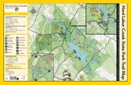
Create successful ePaper yourself
Turn your PDF publications into a flip-book with our unique Google optimized e-Paper software.
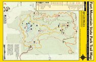
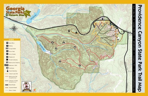
PLEGENDto Florence MarinaPark OfficeParkingGroup ShelterPicnic AreaPicnic ShelterPlaygroundPioneer CampingBackcountry CampingRestroom / ADAOverlooksChurch Building<strong>Canyon</strong> Loop TrailBackcountry Trail(by permit only)<strong>Canyon</strong>s 1-9 Trails(by permit only)Paved RoadsUnpaved RoadsRivers / Creeks39CPARK BOUNDARYNorth Glory HolePARK BOUNDARYSouth Glory HolePARK BOUNDARYPARK BOUNDARY651423PARK BOUNDARY12PARK BOUNDARY39CPARK BOUNDARYPPARK BOUNDARY1PARK BOUNDARY2 3PARK BOUNDARY489PARK BOUNDARY567PARKENTRANCEPARK BOUNDARYto LumpkinWillard Overby Roadto GA Highway 27PARK BOUNDARY39CRoute 1, Box 158 • Lumpkin, GA 31815 • 229-838-6202 • Emergency: 911 • www.<strong>Georgia</strong><strong>State</strong><strong>Parks</strong>.org<strong>Providence</strong> <strong>Canyon</strong> <strong>State</strong> Park Trail Map
PROVIDENCE CANYON STATE PARK<strong>Providence</strong> <strong>Canyon</strong> <strong>State</strong> Park was established in 1971to preserve the unique scenic beauty of “<strong>Georgia</strong>’s LittleGr<strong>and</strong> <strong>Canyon</strong>.” Due to poor farming practices by earlysettlers, the soft soil began washing away in the early 1800swhen trees were cleared to plant crops. By 1850, ditchesthree- to five-feet-deep had been cut into the l<strong>and</strong>. Todaysome of them are as deep as 150 feet. The water graduallycut through the erosion-resistant upper layer of the ClaytonFormation exposing the colorful s<strong>and</strong>y soil known as the<strong>Providence</strong> S<strong>and</strong>s <strong>and</strong> the lower, dark gray layer is knownas the Perote Member. Beneath the <strong>Providence</strong> Formation isthe Ripley Formation, the ancient sea floor, a very erosionresistantclay-like soil that slows the erosion process toa hardly measurable rate, while the sides fo the canyoncontinue to wash downstream.Today, the park covers 1,108 acres with 16 canyons. Themost scenic views are found in the picnic area, wherevisitors can pick up the Rim Trail. Some 43 shades of soilcan be seen, <strong>and</strong> the splendor of the colors -- rangingfrom light orange, salmon, red <strong>and</strong> scarlet to white, purple<strong>and</strong> pink -- is a sight worth seeing. Additionally, beautifulwildflowers grow in the canyons, including the rarePlumleaf Azalea which blooms July to September whilegrowing close to the watercourses far below the canyonridge.Activities & Facilities:Hiking - The park has three miles of hiking trails, whichincludes the <strong>Canyon</strong> Loop Trail. There is also a 7-milebackpacking trail providing access to overnight campingareas.Visitor Center - The center is open 8:00 a.m. - 5:00 p.m.daily <strong>and</strong> includes exhibits, audio-visual presentations <strong>and</strong>information on the area.Camping - Two pioneer camping areas are providedfor organized groups only. Backpackers may use thesix primitve sites found on the Red Blaze Trail (permitsrequired). A modern campground with hot showers islocated nearby at Florence Marina <strong>State</strong> Park in Omaha, Ga.(229-838-6870)Picnicking - The park offers 65 picnic tables <strong>and</strong> twopicnic shelters. Shelters are reservable <strong>and</strong> are availableon a first-come, first-served basis at other times. A groupshelter that accommodates 100 people may be reservedfor a small fee. The shelter has tables, chairs, a grill, stove<strong>and</strong> refrigerator.Annual Events - Spring/Fall Wildflower Days, AstronomyNight, Poster <strong>and</strong> Photography Contests, Geology Days<strong>and</strong> Christmas Decorations Workshop.TRAILS TO HIKE CANYONS 1-9TRAIL DESCRIPTIONS AND PARK INFORMATIONAll trails begin <strong>and</strong> end at the visitor center. To hike canyons 1-5, turn left at the first creek bed on the white blaze trail, <strong>and</strong> canyons 6-9by turning left at the second creek bed.CANYON LOOP (white TRAIL BLAZE) Trail8007507006506005505000 1 2<strong>Canyon</strong> Loop Trail - 2.45 miles2 hours (allow extra time to explore)Compacted Soil SurfaceEASY TO MODERATEThe White Blaze <strong>Canyon</strong> Loop Trail circles nine of the canyons.To hike canyons 1-5 from the Visitor Center, hike ¼ of a miledown to the creek bed, <strong>and</strong> turn left, following the creek bedinto the canyons. Hikers may reach canyons 6-9 by turning leftinto the second creek further down the <strong>Canyon</strong> Loop Trail. Afterarriving at the end of each canyon, backtrack out to return to thetrail. Turn right on the <strong>Canyon</strong> Loop Trail to return to the VisitorCenter, or turn left on the trail to continue the loop. While hikingthrough the day-use area, follow the fence line for the bestoverlooks. The soils are very fragile on the canyon walls, so noclimbing is allowed from the canyon floor or rim. While hikinginto the canyons, it is best to stay in the middle of the creekbeds, because the soils on the side can be very muddy, similarto quicks<strong>and</strong>. The canyon floors are prone to be wet or muddy,so wear appropriate footwear.BACKCOUNTRY (RED TRAILBLAZE) Trail6506005505004504003500 1 2 3 4 5 6 77-mile loop / 6 hours (hiking <strong>and</strong> camping by permit only)Compacted Soil SurfaceEXTREMELY RUGGED & DIFFICULTThe 7-mile Backcountry Trail leads into the forested area off ofthe White Blaze <strong>Canyon</strong> Loop Trail. The beginning of it is ¼ ofa mile down the Loop Trail at the creek bed itself. Instead ofturning left into the canyons, turn right on the creek bed. Thisis the beginning of the Backcountry Trail, which winds throughsome River Birch. After about two miles, it becomes rugged,ascending a steep grade. It follows an old logging road, wheremost of the primitive campsites are located. At site #2, ashortcut is available which will shorten the trail about ¾ of amile. Further down the trail, as the trail becomes rugged again,six canyons may be viewed, but they are not accessible to thehikers. The Backcountry Trail will dead-end into the Loop Trail,where hikers will turn right. This will continue through the dayuse area. Follow the fence line through the picnic area for thebest overlooks, returning to the Visitor Center.SAFETY TIPS & ETIQUETTE• Climbing on the canyon walls from the floor of the canyonsis prohibited.• Climbing on or over the fence line is very dangerous <strong>and</strong> isnot allowed.• The canyon floors are always wet. Wear waterproof bootsto protect your feet.• Tell someone your itinerary <strong>and</strong> expected return time.• Take a map, water, snacks, first aid kit, flashlight <strong>and</strong>whistle. Three short blasts on a whistle are known as a callfor help.• Do not stray from trails. If you become lost, stay in onelocation <strong>and</strong> wait for help. This will make it easier forrescuers to find you.• Don’t count on cell phones to work in the wilderness, butif they do, be able to give details about your location.• Invest in good hiking socks such as those found at sportinggoods stores. Avoid blisters by carrying “moleskin” <strong>and</strong>applying it as soon as you feel hot spots on your feet.Available in the foot care section of drug stores, moleskinis like felt that sticks to your skin.• Be prepared for unexpected rain <strong>and</strong> wind which canlead to hypothermia. Always carry quality rain gear <strong>and</strong>turn back in bad weather. If you become wet or cold, it isimportant to get dry <strong>and</strong> warm as quickly as possible.• To minimize the chance of getting heat exhaustion or heatstroke, drink plenty of fluids, wear lightweight clothing<strong>and</strong> take rests before you get too hot.• Dress in layers <strong>and</strong> avoid cotton. Choose from numerousfabrics that wicks moisture, dry quickly <strong>and</strong> conserve heat.Wear a lightweight shirt that wicks moisture, while carryinga fleece pullover <strong>and</strong> rain jacket.• Pack out all trash.• Keep pets on a leash at all times <strong>and</strong> clean up after them.• Do not pick flowers, disturb wildlife or take anything offthe park.• Protect the park <strong>and</strong> help prevent erosion by staying onmarked trails.• The trails close at 5:30 p.m. from September 15 throughApril 14. They close 30 minutes before sunset during therest of the year.• Day hikers on the 7-mile Backcountry Trail must begin theirhike no later than 2:00 p.m.; overnight hikers must begintheir hike by 4:00 p.m.CLIMATE DATA FOR LUMPKIN, GEORGIAAvg. Avg. Avg.Month High Low Mean Precip. Record High Record LowJan 56ºF 33ºF 44ºF 5.31 in 85ºF (1985) -4ºF(1985)Feb 61ºF 34ºF 48ºF 4.73 in 85ºF (2005) 5ºF (1996)Mar 67ºF 40ºF 54ºF 5.75 in 90ºF (1982) 13ºF (1980)Apr 75ºF 47ºF 61ºF 3.81 in 92ºF (1987) 26ºF (1987)May 81ºF 56ºF 69ºF 3.23 in 99ºF (1979) 34ºF (1997)Jun 86ºF 64ºF 75ºF 3.97 in 105ºF (1978) 40ºF (1999)Jul 89ºF 67ºF 78ºF 5.36 in 104ºF (1980) 52ºF (1967)Aug 89ºF 67ºF 78ºF 3.64 in 105ºF (1980) 52ºF (1997)Sep 85ºF 62ºF 74ºF 3.16 in 100ºF (1980) 31ºF (1967)Oct 76ºF 50ºF 63ºF 2.48 in 93ºF (2002) 27ºF (1981)Nov 68ºF 41ºF 54ºF 3.75 in 89ºF (2004) 16ºF (1969)Dec 58ºF 35ºF 47ºF 4.05 in 81ºF (1984) -1ºF (1983)