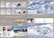
Footpaths, Snow shoes & Cross-Country skiing - Les Gets
Footpaths, Snow shoes & Cross-Country skiing - Les Gets
Footpaths, Snow shoes & Cross-Country skiing - Les Gets

Create successful ePaper yourself
Turn your PDF publications into a flip-book with our unique Google optimized e-Paper software.
2Contents1- Walks<strong>Les</strong> Chavannes........................................................ 04/05Marked, groomed trails (walkers and snow <strong>shoes</strong>)• Belvédère des Nauchets ............................................ 06• Sous le Ranfoilly........................................................... 07• Le Pléney................................................................... 08• <strong>Les</strong> <strong>Gets</strong> village via La Mouille Ronde................................. 09Marked, ungroomed trails (snow <strong>shoes</strong> only)• Le Tour du Golf............................................................ 10• Tour du lac de la Mouille au Blé ................................... 11Le Mont Chéry ........................................................ 12/13Panorama from the top of Mont Chéry................ 14/15Marked, groomed trails (walkers and snow <strong>shoes</strong>)• Mont Caly ............................................................. 16• La Combe .................................................................. 17• Le Bouchet ................................................................ 18Marked, ungroomed trails (snow <strong>shoes</strong> only)• Lassare ................................................................. 19• <strong>Les</strong> Cornuts via le Col de Lachat ....................................... 20• Tour du Mont Chéry...................................................... 21: Specially designed for families
32- <strong>Cross</strong>-<strong>Country</strong> <strong>skiing</strong><strong>Les</strong> Chavannes........................................................ 22/23Le Mont Chéry......................................................... 24/253- Sledging Runs........................................ 26/274- General Information• Our heritage.......................................................... 28 to 32• The history of snow <strong>shoes</strong>................................................ 33• Discoveries along the way............................................ 34/35• Ideas for local walks........................................................ 36• What to do in case of accident?.......................................... 37• The Environment........................................................... 38
4<strong>Les</strong> ChavannesChavannes Map:Marked, groomed trails (walkers and snow <strong>shoes</strong>)• Belvédère des Nauchets• Sous le Ranfoilly• Le Pléney• <strong>Les</strong> <strong>Gets</strong> village par la Mouille RondeMarked, ungroomed trails (snow <strong>shoes</strong> only)• Le Tour du Golf• Tour du lac de la Mouille au BléPOINTE DE MYON(2019m)TC PLENEYAccès depuis Morzine1505mTS de NaborTS BelvédèreGOLFTS Folliets du GolfNABORLES FOLLIETSLA CULAZLES LANCHETTESGIBANNdu StadeversMORZINEPatinoireLES G117
<strong>Footpaths</strong> 5ParkingTourist OfficeLift-Pass OfficeSki-lift open to pedestriansToiletsBenchMountain restaurantView pointAlpine chaletSledging runFirst-aid pointsMinibus stopLE RANFOILLY1850mSous Le Ranfoilly1620mau Roi RoiTêtedes Crêts CrêtsTS la CroixLES CHAVANNES1485mTK MouilleTK Grand CryLac de la Mouilleau BléTS Nauchet ExpressBelvédèredes NauchetsTS Ranfoilly ExpressTS Mouille aux ChatsLA MOUILLERONDETS La RostaTS Grains d’Or ExpressAZTK B. de GommeETS2mTC ChavannesTS Chavannes ExpressTK du VieuxChêne ChêneEspacede LoisirsLacsdes EcolesLA TURCHETK de la TurcheTK du ChâteauTS Perrières Express
6<strong>Les</strong> ChavannesE MYON9m)le Belvédère des NauchetsDuration: 20 minAltitude difference: (Ascent) 30 m, (Descent) 30 mLength:1,2 kmDifficulty: ❆Departure point: Chavannes cable car (1485 m)Arrival point: Belvédère des Nauchets (1485 m)<strong>Footpaths</strong>familiesLE RANFOILLY1850mau RoiTêtedes Crêts CrêtsTS la CroixLES CHAVANNES1485mTK MouilleTK Grand CryLac de la Mouilleau BléTS Nauchet ExpressBelvédèredes NauchetsTS Ranfoilly Express ExpressTS Mouille aux ChatsLA MOUILLERONDETS GraLES LANCHETTESGIBANNAZPatinoiredu StadeTK B. de GommeTC ChavannesTS Chavannes ExpressTK du VieuxChêne ChêneEspacede LoisirsLacsdes EcolesLA TURCHETK de la TurcheALES GETSn easy 1172m trail designed for families with young children and perfectfor an afternoon snack. Picnic tables and games for young childrenare available next to the Indians’ house.TK du ChâteauTS Perrières ExpTake the path through the Mappys beginner area near the Grand CryTerritory. Return on the same path.
<strong>Footpaths</strong>7Sous le RanfoillyDuration: 1hAltitude difference: (Ascent) 150 m , (Descent) 30 mLength: 2,7 kmDifficulty: ❆ ❆Departure point: Chavannes cable car (1485 m)Arrival point: Sous le Ranfoilly (1620 m)LE RANFOILLY1850mSous le Ranfoilly1620mau RoiTêtedes Crêts CrêtsTS la CroixLES CHAVANNES1485mTK MouilleTK Grand CryLac de la Mouilleau BléTS Nauchet ExpressBelvédèredes NauchetsTS Ranfoilly Express ExpressTS Mouille aux ChatsLA MOUILLERONDETS GrainsNCHETTESPatinoireAGIBANNAZpleasant walk on a wide, groomed track with benches and a superbview. Perfect for a picnic or to meet up with skiers.TC ChavannesBeautiful views of the La Rosta, Pointe de la Turche, Pic du Marcelly andLA TURCHEMont Caly peaks and the Uble and Mont Chéry mountains. Take the paththrough the Mappys and Grand Cry Territory beginner ski areas. Take thesame LES GETS path to return.1172mTake care when crossing ski pistes.du StadeTK B. de GommeTS Chavannes ExpressTK du VieuxChêne ChêneEspacede LoisirsLacsdes EcolesTK de la TurcheTK du ChâteauTS Perrières Express Express
8<strong>Les</strong> Chavannesle PléneyDuration: 1hAltitude difference: (Ascent) 100 m, (Descent) 90 mLength: 2,8 kmDifficulty: ❆ ❆Departure point: Chavannes cable car (1485 m)Arrival point: Pléney cable car (1505 m)POINTE DE MYON(2019m)TC PLENEYAccès depuis Morzine1505mNABORTS de NaborTS BelvédèreGOLFTS Folliets du GolfLA CULAZLES FOLLIETSLES LANCHETTESGIBANNAZThis walk offers magnificent panoramic views over the Morzine andversPatinoireMORZINEManche valleys, the Plateau de Nyon and Avoriaz.LES GETS1172mFollow the path along the cross-country ski piste. At the junction withthe Crocus ski piste, turn right and climb along the ski piste to the Follietschair- lift arrival point. Take the track that goes behind the arrival point andcontinue to the Pléney cable car. Take the same path to return.du StadeTK B. de GommeTC Chavannesau RoiTS Chavannes ExpressTêtedes Crêt CrêtTS laLES CHAV1485mTK MouilleEspde LoTK du VieuxChêne ChênePlease take care to keep to the designated routes and avoid walking on thecross-country ski pistes.
<strong>Footpaths</strong>9les POINTE DE MYON <strong>Gets</strong> village via La Mouille Ronde(2019m)Duration: 1h30LE RANFOILLY1850mAltitude difference: (Ascent) 0 m, (Descent) 350 mLength:4,4 kmAlternative (----) : 1h45 (par la route au niveau du lac des Ecoles )Difficulty: ❆ ❆Departure point: Chavannes cable car (1485 m)Arrival point: <strong>Les</strong> <strong>Gets</strong> village (1172 m)au RoiTêtedes Crêts CrêtsTS la CroixLES CHAVANNES1485mTK MouilleTK Grand CryLac de la Mouilleau BléTS Nauchet ExpressBelvédèredes NauchetsTS Ranfoilly Express ExpressTS Mouille aux ChatsLA MOUILLERONDESous le Ranfoilly1620mTS La RTS Grains d’Or Expresslliets du GolfLES FOLLIETSZLES LANCHETTESGIBANNAZdu StadeTK B. de GommePatinoireLES GETS1172mTC ChavannesTS Chavannes ExpressEspacede LoisirsTK du VieuxChêne ChêneLacsdes EcolesLA TURCHEEnjoy some family time on this walk through the leisure areas, passingthe Lac des Ecoles, le Ranch, a playground, a sledge run…Head towards the Mappys beginner area. The road on the right is the onlypath in the Chavannes area which leads back into <strong>Les</strong> <strong>Gets</strong> village. As youwalk through the forests and clearings, you will discover animal tracksleading you close to the Lac des Ecoles. Then, walk behind the schoolsand head back down in the direction of the second sledge run.Alternative : You can also return on the road.TK de la TurcheTK du ChâteauTS Perrières Express Express
10<strong>Les</strong> Chavannesle Tour du GolfDuration: 1h30 to 2h30POINTE DE MYON(2019m)Altitude difference: (Ascent) 120 m, (Descent) 120 mLength: 5 kmDifficulty: ❆ ❆Départ / Arrival point: Chavannes cable car (1485 m)orzineTS de NaborTS BelvédèreGOLFTS Folliets du Golfau RoiTêtedes Crêts CrêtsTS la CroixLES CHAVANNES1485mTK MouilleTK Grand CryLacauBORCLA CULAZLES FOLLIETSLES LANCHETTESGIBANNAZlose to the Lac du Golf this is a magnificent path winding throughforests and clearings.PatinoireTake the pedestrian road from the Chavannes cross-country LES GETS ski piste1172mto an area called ‘La Basse’, then turn left into the forest. Part of thiswalk is on the groomed footpath.du StadeTK B. de GommeTC ChavannesTS Chavannes ExpressEspacede LoisirsTK du VieuxChêne ChêneLacsdes EcolesPlease take care to keep to the designated routes and avoid walking on thecross-country ski pistes.
<strong>Snow</strong> <strong>shoes</strong>11le Tour du lac de la Mouille au BléDuration: 1h to 1h30Altitude difference: (Ascent) 90 m, (Descent) 90 mLength:2,5 kmDifficulty: ❆Départ / Arrival point: Chavannes cable carLE RANFOILLY1850mSous le Ra1620mTS Ranfoilly Express Expressau RoiTêtedes Crêts CrêtsTS la CroixLES CHAVANNES1485mTK MouilleTK Grand CryLac de la Mouilleau BléTS Mouille aux ChatsTS Nauchet ExpressBelvédèredes NauchetsLA MOUILLERONDELANCHETTESPut on your trapper’s hat and start this walk following the tracks of thenumerous wild animals that roam the area. Both picnic tables andchildren’s GIBANNAZgames are available beside the Indians’ house. This track passesthe Mappys beginners Espace area and circles the artificial Mouille au Blé lake.TC ChavannesTracking Game !!!LA TURCHEDuring your walk, look out for the letters printed on each sign, andarrange them in the correct order to discover the name of a well-knownmountain LES GETS flower.1172mPatinoiredu StadeTK B. de GommeTS Chavannes ExpressTK du VieuxChêne Chênede LoisirsLacsdes Ecoles■ ■ ■ ■ ■ ■ ■ ■ ■TK de la TurTK du Château
12Le Mont Chéry▲North Side / ▼Village SidePOINTE D’UBLE1963mLE PRAZ DE LYSTour du Mont-Chéry(voir Chéry Nord)MONT CALY1489mCol de Lachat1632mVariante par la routeLES PLACES1386mMAGYGRANGETTESMOUDONLE LAITELA COMBELES CORNUTSLE BOUCHETLES PERRIERESLES GRANGESLE BENNEVY
<strong>Footpaths</strong> 13Tourist OfficeLift-Pass OfficeSki-lift open to pedestriansDépart des sentiersToiletsBenchMountain restaurantView pointAlpine chaletFirst-aid pointsMinibus stopMont Chéry Map:Marked, groomed trails (walkers and snow <strong>shoes</strong>)• Mont Caly• La Combe• Le BouchetPOINTE DE CHALUNE2116mMarked, ungroomed trails (snow <strong>shoes</strong> only)• Lassare• <strong>Les</strong> Cornuts via le Col de Lachat• Tour du Mont ChéryLE ROC D’ENFER2243mMONT CHERY1826mTS la PointeTK Super ChéryTS Grande OurseTS Planeys1525mTC Mont ChéryLES LONGUES POSESLES METRALLINSLASSARE1337m
14Mont ChéryEnjoy the incredible panoramic view of the Mont Blancmountain chain from the top of the Mont Chéry cable car…Mont-Blanc du Tacul4248 mDent du Géant4013 mAiguille du Midi3842 mMont-Maudit4465 m
Panorama15Mont-Blanc4810 mDôme du Goûter4305 mBionassay4052 m
16Le Mont ChéryMont CalyDuration: 1hAltitude difference: (Ascent) 80 m, (Descent) 120 mLength: 3,1 kmDifficulty: ❆Departure point: Mont Chéry cable car (1525 m)POINTE D’UBLE1963mArrival point: Mont Caly (1445 m)POINTE DE CHALUNE2116mLE ROC D’ENFE2243m)ryMONT CALY1445m 1489mCol de Lachat1632mMONT CHERY1826mTS la PointeTK Super ChéryTS Grande OurseTS Planeys1525mLAITEBELES CORNUTSLE BOUCHETLES PERRIERESALES PERRIERESLES GRANGESs you leave the Mont-Chéry cable car, take the left passage by the LaPointe chai r-lift. Then, take the high track leading through forests andsnowy fields. Enjoy the magnificent view over the Mont-Blanc range and,LES GETSfurther on, let the Mont Caly pastures delight you by their 1172mcalm and charm.When you get to Mont Caly, you can either return on the same path orkeep going to ‘<strong>Les</strong> Places’ and take the road down to take the minibus ateither ’La Combe’ (Line A – Stop No 8) or Magy (Line A – stop No 9).Minibuses pass every 30 minutes.LE BENNEVYTC Mont ChéryLES LONGUES POSESLES METRALLINS
<strong>Footpaths</strong>17La CombeDuration: 2h15Altitude difference: (Ascent) 90 m, (Descent) 400 mLength: 6,8 km<strong>Snow</strong> Shoe alternative (----) : from the <strong>Les</strong> Places car park (allow 2hrs)Difficulty: ❆ ❆Departure point: Chéry cable car (1525 m)POINTE Arrival point: La Combe (1210m). (Minibus liaison – every 30 minutesDE CHALUNE2116mto return to <strong>Les</strong> <strong>Gets</strong>.) – Line A.POINTE D’UBLE1963mLE PRAZ DE LYSMONT CHERY1826mMONT CALY1489mCol de Lachat1632mVariante par la routeLES PLACES1386mTS la PointeTK Super ChéryTS Grande Ourse1525mMAGYGRANGETTESMOUDONLE LAITELA COMBELES CORNUTSLE BOUCHETLES PERRIERESLES GRANGESLE BENNEVYTC Mont ChéryLES LONGUESLESA dmire the Mont-Blanc mountain chain, the Chavannes area and theLES GETS1172mAravis on this spectacular walk.Leave from the top of the Mont Chéry cable car next to the La Pointe chair-lift.The first part is the same as the Mont Caly walk and then return to the villagevia the hamlet of <strong>Les</strong> Places where you re-join the tarmac road. There is achoice of two minibus stops: either the La Combe stop (Line A – stop No 8)or Magy (Line A – stop No 9). Minibuses pass every 30 minutes.
18<strong>Footpaths</strong>Le BouchetDuration: 1h30Altitude difference: (Ascent) 0 m, (Descent) 365 mLength: 4,5 km<strong>Snow</strong> Shoe alternative (----) : 2hDifficulty: ❆ ❆ ❆POINTE D’UBLEPOINTE DE CHALUNE2116m1963mDeparture point: Mont Chéry cable car (1525 m)Arrival point: <strong>Les</strong> <strong>Gets</strong> village (1172m), (Minibus liaison – every 30minutes to return to <strong>Les</strong> <strong>Gets</strong>.) – Line C.LE ROC D’ENFER2243mMONT CHERY1826mT CALY89mCol de Lachat1632mTS la PointeTK Super ChéryTS Grande OurseTS Planeys1525mLE BOUCHETLES GRANGESLE BENNEVYTC Mont ChéryLES LONGUES POSESLES METRALLINSA LES GETScharming walk through the small hamlet of Bouchet 1172mwith pretty viewsof Chavannes, La Turche and <strong>Les</strong> Perrières.The path is fairly steep at the start. Walking poles are recommended.
<strong>Snow</strong> <strong>shoes</strong>19INTE D’UBLE1963mLassareDuration: 1h30Altitude difference: (Ascent) 0 m, (Descent) 365 mLength: 5,1 kmAlternatives (----) : Two snow-shoe circuits at Plan Bôdit. A small,POINTE DE CHALUNE2116mLE ROC D’ENFERbeginners circuit: 2.9 km or a larger 2243mcircuit: 3.7 km.Difficulty: ❆ ❆Departure point: Mont Chéry cable car (1525 m)Arrival point: <strong>Les</strong> <strong>Gets</strong> village (1172 m)MONT CHERY1826mTS la PointeTK Super ChéryTS Grande OurseTS Planeys1525mLE BENNEVYTC Mont ChéryLES LONGUES POSESLES METRALLINSLASSARE1337mTLESake this path and enjoy the wooden sculptures along the way, thenGETS1172mpause at the <strong>Les</strong> <strong>Gets</strong> Bergerie/Pottery . This walk also offers magnificentpanoramic views of the Roc d’Enfer, the Côte d’Arbroz and Nantaux.As you leave the Mont Chéry cable car, turn right and take the wide pathas far as ‘Plan Bôdit’, then head down to the left. Return to the village onthe road.
20Le Mont Chéry<strong>Les</strong> Cornuts via le Col de LachatDuration: 2 hAltitude difference: (Ascent) 155 m, (Descent) 440 mLength: 4,2 kmDifficulty: ❆ ❆POINTE D’UBLE1963mPOINTE DE CHALUNE2116mDeparture point: Mont Chéry cable car (1525 m)Arrival point: <strong>Les</strong> Cornuts (take the minibus to return to the village) Line A.héryrd)MONT CALY1489mCol de Lachat1632mMONT CHERY1826mTS la PointeTK Super ChéryTS Grande Ourse1525mTESLE LAITEOMBELES CORNUTSLE BOUCHETLES PERRIERESLES GRANGESLE BENNEVYs you leave the Mont Chéry cable car, take the left passage by theA La Pointe chair-lift. Then take the high track leading through forestsand snowy fields.LES GETS1172mThis walk has far-reaching views over the village and mountains. It is acharming path alternating between forests and clearings. Above the alpinevillage of Mont Caly, follow the sign Col de Lachat which takes you to thepeaks. To return, take the minibus from <strong>Les</strong> Cornuts (Line A – Stop No7).Minibuses pass every 30 minutes.TC Mont ChéryLES LONGUES POSESLES METRA
Sentiers raquettes21Tour du Mont ChéryDuration: 4h to 8h depending on conditionsAltitude difference: (Ascent) 400 m, (Descent) 400 mLength: 8,5 kmDifficulty: ❆ ❆ ❆Départ / Arrival point: Mont Chéry cable car (1525m)/<strong>Les</strong> Places (1386m)Leave the hamlet of <strong>Les</strong> Places (accessed via the route de Mont Calyfrom <strong>Les</strong> <strong>Gets</strong>). Take the forest path down to the hamlet of ‘Bonnavaz’,where you cross the first bridge. Then take the groomed track to the secondbridge. The path now follows the winding track climbing into the forestand up to the Col de l’Encrenaz. Then climb the north slope of Mont Chérywith a lovely view of the Roc d’Enfer and Praz de Lys. Above the forest, youcross a large expanse of snow to return to the charming alpine village ofMont Caly with magnificent views of the Mont Blanc chain.Attention: this is a long and difficult circuit and is not recommendedwhen snow or fog are forecast. Why not contact a mountain guide to helpyou take full advantage of this wonderful walk?
22<strong>Cross</strong>-<strong>Country</strong> SkiingParkingTourist OfficeLift-Pass OfficeToiletsMountain restaurantView pointAlpine chaletFirst-aid pointsPOINTE DE MYON(2019m)Accès depuisTC Pleney(Morzine)TS de NaborTS BelvédèreGOLFTS Folliets du GolfTK Mouille MouilleLESNABORLES FOLLIETSLA CULAZLES LANCHETTESGIBANNAZversMORZINETK du StadeTK B. de GommeLES GETS1172mTC ChavannesTS Chava
23<strong>Les</strong> Chavannes• Green circuitDuration: 20 minLength: 920 mAltitude difference: 25 m• Blue circuitLE RANFOILLY1850mDuration: 50 minLength: 3,3 kmRanfoilly ExpressAltitude difference: 90 mau Roi RoiTêtedes Crêts CrêtsTS la CroixCHAVANNES1485m• Red circuit(The red part of the circuit is only open in verygood snow conditions.)Duration: 1 h 05LA MOUILLELength: RONDE4,4 kmAltitude difference: 105 mNauchet ExpressBelvédèredes NauchetsMouille aux ChatsLa RostaGrains d’Or ExpressLA ROSTA1665mnnes ExpressTK du VieuxChêne ChêneEspacede LoisirsThe colours of the pistes relate to the length ofthe circuit and not to the technical difficulty.Please be aware that the circuit durations givenare an indication only for beginner level and willLA TURCHEvary greatly depending on individual fitness andexperience.de la Turchedu ChâteauPerrières Express
MONT18224<strong>Cross</strong>-<strong>Country</strong> SkiingParkingTourist OfficeLift-Pass OfficeToiletsMountain restaurantView pointAlpine chaletFirst-aid pointsPOINTE DE CHALUNE2116mPOINTE D’UBLE1963mMONT CALY1489mCol de Lachat1632mTS la PointeTK Super1525mAITEELE BOUCHETLES PERRIERESLES GRANGESLE BENNEVYTC Mont ChéryLES GETS1172m
25Le Mont ChéryLE ROC D’ENFER2243m• Blue circuitDuration: 45 minLength: 2,9 kmAltitude difference: 100 mCHERY6m• Red circuitDuration: 1 h 10Length: 6,8 kmAltitude difference: 200 mChéryTS Grande OursePlaneys• Black circuitDuration: 1h50Length: 7,3kmAltitude difference: 220mThecolours of the pistes relate to thelength of the circuit and not to thetechnical LE BENEVIX difficulty. Please be aware thatLASSARE1337mthe circuit durations given are an indicationonly for beginner level and will varygreatly depending on individual fitness andexperience.
26Sledging PistesThere are 5 safe, maintained, sledging slopesavailable for your use in the resort:1- Vieux-Chêne : about 50m of slope / from 2 to 6 yrs2- Chavannes : about 50m of slope / from 4 to 6 yrs3- Perrières : 100 m of slope / children over 6yrs4- Lac des Ecoles : about 40m of slope / from 2 to 5 yrs5- Le Carry (snow line): about 25 m of slope / from 2 to 5 yrsWe remind you that you are strongly advised towear a helmet when sledging and that sledgingis prohibited in the ski area at any time – day or night.
27LE RANFOILLY1850mSous le Ranfoi1620mTS Ranfoilly Express Expressau RoiTêtedes Crêts CrêtsTS la CroixLES CHAVANNES1485mTK MouilleTK Grand CryLac de la Mouilleau BléTS Mouille aux ChatsTS Nauchet ExpressBelvédèredes NauchetsLA MOUILLERONDETESTK de la TurcheGIBANNAZdu StadeTK B. de GommetinoireLES GETS1172mTC ChavannesTS Chavannes ExpressEspacede LoisirsChêne ChêneTK du VieuxLacsdes EcolesLA TURCHETK du Château
28General Information<strong>Les</strong> <strong>Gets</strong> is a mountain village onslopes that stretch between an altitudeof 940m at the Pont de <strong>Gets</strong> to1848m at Mont Chéry. The villagecentre is at an altitude of 1172m.Here, the altitude is a determiningfactor for climate, vegetation andthe way of life.This ancient Oak is 700 years old and has a 7.5m circumference.In 1996 the FRAPMA Rhone-Alps officially designated it ‘MostBeautiful Tree’.Our HeritageThe story of how a villagebecame a resortThe life of men and women in themountainsLe Pont des <strong>Gets</strong>Until the 10 th century, the area waspractically uninhabited althoughpeople from the valley came up tocollect their wood. This explains thetoponym ‘<strong>Gets</strong>’ which can be foundin archives as either gietos, giettorumor geits - all of which mean‘passages’ or corridors throughwhich the cut trees were slid downinto the valley. Derivations are commonplace names in our region :Giex, Gy, Giettaz and even Gex havethe same etymology.Before winter sports and tourism,pasture, wood and water were theprincipal resources of the <strong>Les</strong> <strong>Gets</strong>inhabitants. They used spruce andpine to build their homes: fromthe structure to the fireplace, andfrom the walls to the tavaillons(wood roof tiles). Everything waswood. Wood was also used to makecooking utensils, spoons, buckets…
29and agricultural tools, forks, rakes(from ash and beech), scythe handlesfrom maple, coffi from birchand alder; sledges to slide the woodenlogs over the snow in winter,sledges to transport manure inspring and sledges to bring thehay and harvest into the barns insummer.The coffi, attached to the belt of aharvester, was used to sharpen hisscythe blade.Water worked the sawmills in thespring when the seasonal meltingsnow increased the flow of waterenabling the sawmills to work dayand night.During this period, ‘Des <strong>Gets</strong>’ werepeasants who raised cows, madetheir cheese (Tomme), killed theirpigs and smoked charcuterie inthe big , open fireplace (la bourne).They went up to the pastures insummer, cultivated a few cerealsto feed their horse and make bread,and grew kohlrabies and potatoes(in patois tartifle) to accompanytheir daily meals.Life was hard, but was not withouttime for relaxation betweenneighbours and family. In the village,everyone knew each otherand was, in fact, more or less relatedbecause marriages usuallytook place between young peoplefrom the village. This explains whythe names of these families are stillthe same today as they were in ancientdocuments.
30Informations généralesIn the 13 th Century land registry,contracts carried the names of Comtat,Bergoens, Coppelli, DouCret,Mungnerii, Anthonioz, Baudi…The adjective ‘gétois’ is very new.Until recently, one spoke of ‘ Des<strong>Gets</strong>’ (The <strong>Gets</strong>).During the second half of the 19thCentury, life began to change. Thevillage, having belonged to theLords of Faucingy from the 11th tothe 14th century and administeredby the Benedictines of Contamine/Arve from the end of the 11 th centuryto the 17 th century, becamethe land of the Counts of Savoie in1355 and, finally in 1860, the Savoiebecame French.built. In 1895, the parish churchwas demolished and a new onebuilt in much the same place. Thesame year, and for the first time in<strong>Les</strong> <strong>Gets</strong>, a school was built at <strong>Les</strong>Perrières, for the numerous childrennow living in the village. Three hotelswere renovated or built at theend of the century, and travellersand families began to arrive drawnby the fashion of spending a monthor two in the clean, mountain air. In1910, a school complex, town halland teachers’ housing were built inthe village centre. This building isnow the Maison des <strong>Gets</strong>.In 1884 the current road alongthe Arpettaz, climbing throughTaninges - The Grandes Alpes Road -from Thonon-les-Bains to Nice, was
31The Birth of Winter Sports.Winter sports were born with thearrival of the first skiers. It wasn’tuntil the 1930s that the first skitracks appeared on the snowyslopes of Le Carry. On Sundays, theGenevois began to arrive in largenumbers. Groups of 10 – 15 skiersmet at a hotel for the ‘Weekend’and climbed up Chavannes onseal skins. They had breakfast atthe Croix Blanche and carried onto Ranfolly from where they couldfinally ski down to the village!The first drag lift, at La Boule deGomme, was installed in 1936.In 1946 the draglift at Puthays,towards La Turche, was openedand was joined in 1952 by anotherat Mont Chery. The Chavannescable car dates from 1973 and theMont Chery cable car from 1981.The pulleys and poles were madeof wood and the seats were bicycleseats! In 1947 a prototype chairlift was tested at Chavannes with agenerator to power the “télé porté”.
32Informations généralesand the international association“The Portes du Soleil”* whichgrouped together 8 French and 4Swiss ski resorts.In 1988 the Chavannes drag lift wasreplaced by a 4-man chair lift.During the winter of 1940, DésiréBlanc opened the first ski school.The Chavannes road was openedin 1963, and a municipal ski- liftorganisation was founded.During the 1970s, <strong>Les</strong> <strong>Gets</strong> becamepart of the ‘Stations-Village Savoie’association (promoting harmoniousdevelopment in the village)*International association of thePortes du Soleil:In France : <strong>Les</strong> <strong>Gets</strong>, Morzine, Avoriaz,Abondance, Châtel, La Chapelled’Abondance, Montriond,St Jean d’Aulps ;In Switzerland : Morgins, Torgon,Champéry, <strong>Les</strong> Crosets, Val d’Illiez.
33The history ofsnow-<strong>shoes</strong> …The use of snow <strong>shoes</strong> dates fromprehistoric times. Prehistoric manhad problems moving around insnowy conditions. The idea wasto find a way of walking on thesnow without sinking in. The original<strong>shoes</strong> were made with pinebranches attached beneath thefeet. <strong>Snow</strong> <strong>shoes</strong> enabled huntersto keep on the surface of the snowand move more quickly.The name ‘raquette’ came from 17thcentury settlers who saw Indianswalking with these accessoriesthat resembled the rackets usedin tennis.Since the middle of the 19th century,snow <strong>shoes</strong> have been used forleisure and the design has improvedsignificantly as a result.Different types of snow<strong>shoes</strong>:Naskapiou queued’hirondellePattes d’oursMontagnaisou queuede castorOjibway
34Discoveries along the way…Our mountains and forests are home to rich and varied fauna. Duringyour walks you will perhaps have the chance to see a squirrel,a hare or a chamois. Animal spotting is also about finding traces of theireveryday life: How interesting would it be to find an animal foot printand try to work out which animal left it?Over to you….RED DEER FOOTPRINT9 cm longWILD BOAR FOOTPRINT INTHE SNOWCHAMOIS FOOTPRINT4 cm longIMPRINT OF A LEAPINGSQUIRRELTYPICAL FOOTPRINT OF AMOVING HAREFOOTPRINT OF A RUNNINGFOX Pas traînantWEASEL OR PINE MARTENFOOTPRINTFOOTPRINT OF A RODENTFORAGING FOR FOODFOOTPRINT OF A BADGERWITH LONG CLAWSASWild Boar, B Squirrel, C Red deer,D Fox, E Chamois, F Weasel or Marten,G Badger, H Rodent foraging for food,I Hare.
35ABCDEFGHI
36Practical InformationThe Tourist Office is available to provide furtherinformation and advice on local walks:• The Sentier du Renard in Morzine• The Tour de lac de Montriond up to the Cascade d’Ardent (snow<strong>shoes</strong>)• The Crêtes de Zorre at Super Morzine• The banks of the Dranse river from Morzine to St Jean d’Aulps• The Col de la Basse (snow <strong>shoes</strong>)• The Boucle de Molly at Praz de Lys (snow <strong>shoes</strong>)• The cirque du Fer à Cheval and the Rouget waterfall at Sixt Fer àCheval (snow <strong>shoes</strong>).
37A Quick ResponseSki patrol first-aiders are at your service on the pistes and in the first-aidstations (signs with a red cross).What to do in case of accident?Take the name of the track and the number of the closest marker to theaccident. Head to the nearest ski lift or first-aid station and pass on thisinformation.<strong>Les</strong> <strong>Gets</strong> Piste Service: +33 (0)4 50 79 72 22International Emergency Number: 112Weather: +33 (0)8 92 68 02 74 - www.chamonix-meteo.com
38Practical InformationEnvironment• • Protect the mountain together. It’s your responsibility too !• Throw your rubbish in the bins or keep it in your bag.• Use pocket ash trays (free from lift offices).• Only take one walking map for your stay.• Do not take unmarked paths and tracks as this disturbs the wildlife.• The Tourist Office and the Lift Company are certified ISO 14001 andAlpine Pearls in recognition of the effectiveness of their environmentalmanagement systems.Respect the wildlife. Don’t leave the marked tracks.Keep your dog on a lead.
Pine forests sparkling with snowCome, escape to immaculate, snowy plateauxHere and there traditional chalets and farms,breath-taking viewsNature at its most beautiful is waiting for you…39
Get up- to-date resort information in real time via your mobile.(news, diary, webcams, weather, directories, activities…)Connect to m.lesgets.com or scan the following code:Summer Too! Come anddiscover our activitiesOffice de Tourisme des <strong>Gets</strong>Tourist Office89, Route du Front de neige74260 <strong>Les</strong> <strong>Gets</strong>Tél. : +33 (0)4 50 75 80 80Email : lesgets@lesgets.comwww.lesgets.com