climate and currents - Activity 1
climate and currents - Activity 1
climate and currents - Activity 1

You also want an ePaper? Increase the reach of your titles
YUMPU automatically turns print PDFs into web optimized ePapers that Google loves.
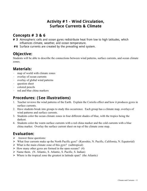
<strong>Activity</strong> #1 - Wind Circulation,Surface Currents & ClimateConcepts # 3 & 6# 3 Atmospheric cells <strong>and</strong> ocean gyres redistribute heat from low to high latitudes, whichinfluences <strong>climate</strong>, weather, <strong>and</strong> ocean temperature.#6 Surface <strong>currents</strong> are created by the prevailing wind system.Objective:Students will be able to describe the connections between wind patterns, surface <strong>currents</strong>, <strong>and</strong> ocean <strong>climate</strong>zones.Materials:· map of world with <strong>climate</strong> zones· overlay of ocean <strong>currents</strong>· overlay of global wind patterns· question sheet· colored pencils· red <strong>and</strong> blue china markersProcedures: (See illustrations)1. Teacher reviews the wind patterns of the Earth. Explain the Coriolis effect <strong>and</strong> how it produces gyres insurface <strong>currents</strong>.2. Have students break into groups to study this occurrence. Each group has a <strong>climate</strong> map, overlays ofwind patterns <strong>and</strong> surface <strong>currents</strong>.3. Students color the ocean <strong>climate</strong> zones in four different shades of blue, with the tropics being thedarkest.4. Students color the warm surface <strong>currents</strong> with a red china marker <strong>and</strong> the cold <strong>currents</strong> with a bluechina marker. Overlay the surface current sheet on top of the <strong>climate</strong> zone map.Evaluation:! Answer these questions:! What four <strong>currents</strong> make up the North Pacific gyre? (Kuroshio, N. Pacific, California, N. Equatorial)! What is the main <strong>climate</strong> zone of this gyre? (subtropical)! How many other gyres are formed in the open oceans? (4)! Name them. (N. Atlantic, S. Atlantic, S. Pacific, S. Indian)! Where is the tropical zone the greatest in latitude span? (the Atlantic)Climate <strong>and</strong> Currents - 11
Evaluation Continued:Now place the wind pattern overlay over the <strong>climate</strong> zone map. Answer these questions:! Which <strong>climate</strong> zone contains the westerlies? (Temperate zone)! Easterlies bring cold air from where? (the poles)! Now place the current overlay on top of the wind pattern <strong>and</strong> answer these questions:! At what angle are the equatorial <strong>currents</strong> to the trade winds? (45° angle)! Why does this occur? ( Because the Coriolis effect deflects the wind)! What would happen if the trade winds became weaker? (The equatorial current would become weaker<strong>and</strong> create an El Niño effect.)Climate <strong>and</strong> Currents - 12
<strong>Activity</strong> #1 - Wind Circulation, Surface Currents & Climate ZonesGlobal air circulation & wind patternsClimate <strong>and</strong> Currents - 14
<strong>Activity</strong> #1 - Wind Circulation, Surface Currents & Climate ZonesOcean Climate Zones (based on surface temperatures)Climate <strong>and</strong> Currents - 15

![15. RS 1.003 (RaJsu-yeni - nql?) RS 18.056 (RaJsu-yeni -5'[ ... ])](https://img.yumpu.com/51622603/1/189x260/15-rs-1003-rajsu-yeni-nql-rs-18056-rajsu-yeni-5-.jpg?quality=85)